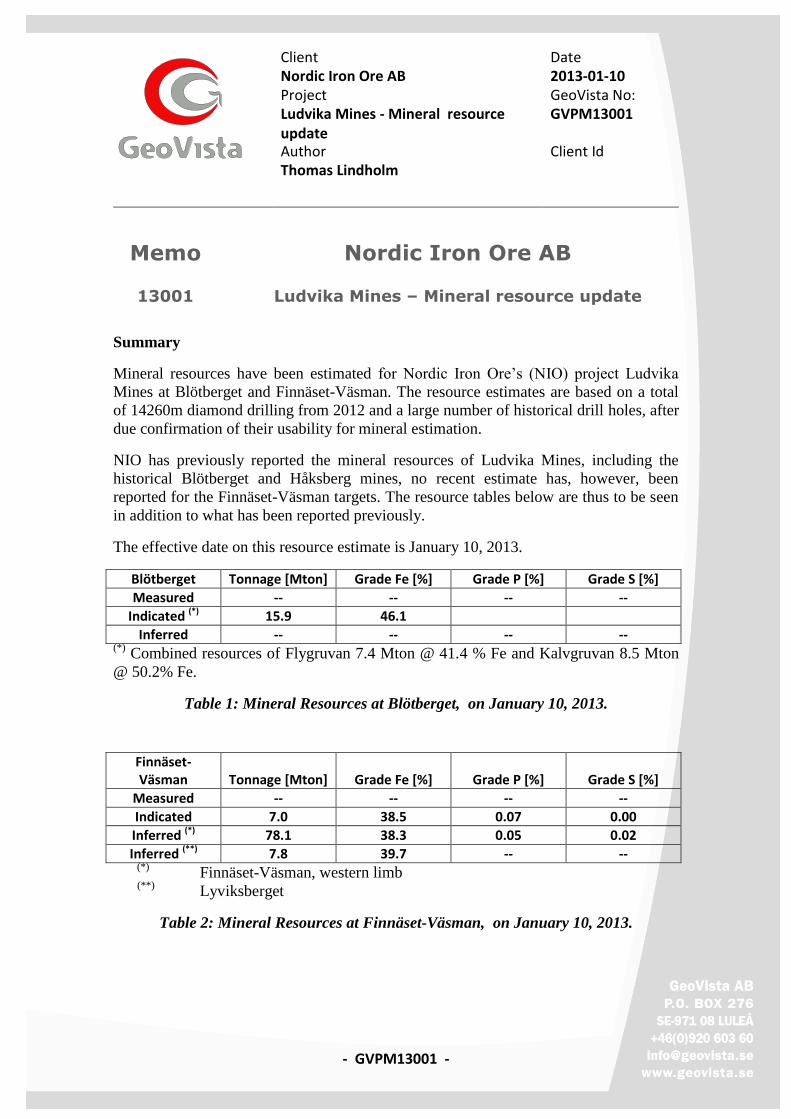
Client Date Nordic Iron Ore AB 2013-01-10 Project GeoVista No: Ludvika Mines - Mineral resource update
GVPM13001
Author Client Id Thomas Lindholm
- GVPM13001 -
Memo Nordic Iron Ore AB
13001 Ludvika Mines – Mineral resource update
Summary
Mineral resources have been estimated for Nordic Iron Ore’s (NIO) project Ludvika
Mines at Blötberget and Finnäset-Väsman. The resource estimates are based on a total
of 14260m diamond drilling from 2012 and a large number of historical drill holes, after
due confirmation of their usability for mineral estimation.
NIO has previously reported the mineral resources of Ludvika Mines, including the
historical Blötberget and Håksberg mines, no recent estimate has, however, been
reported for the Finnäset-Väsman targets. The resource tables below are thus to be seen
in addition to what has been reported previously.
The effective date on this resource estimate is January 10, 2013.
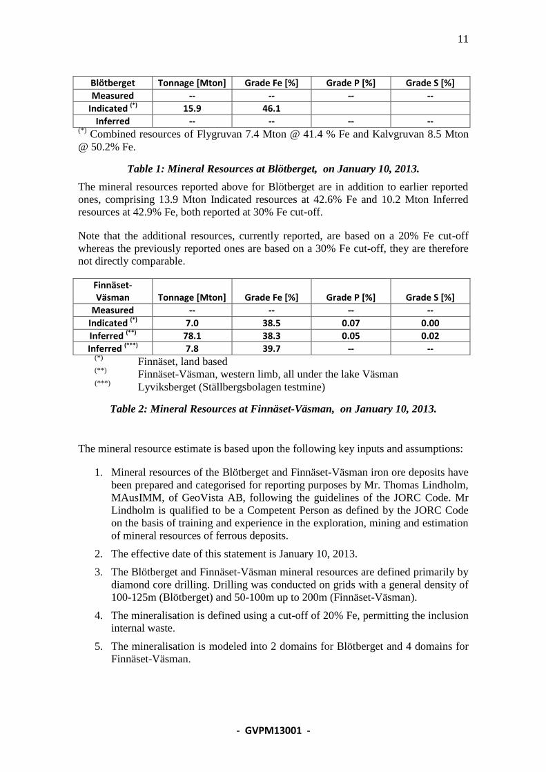
Blötberget Tonnage [Mton] Grade Fe [%] Grade P [%] Grade S [%]
Measured -- -- -- --
Indicated (*) 15.9 46.1
Inferred -- -- -- -- (*)
Combined resources of Flygruvan 7.4 Mton @ 41.4 % Fe and Kalvgruvan 8.5 Mton
@ 50.2% Fe.
Table 1: Mineral Resources at Blötberget, on January 10, 2013.
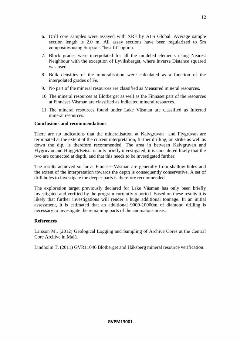
Finnäset-Väsman Tonnage [Mton] Grade Fe [%] Grade P [%] Grade S [%]
Measured -- -- -- --
Indicated 7.0 38.5 0.07 0.00
Inferred (*) 78.1 38.3 0.05 0.02
Inferred (**) 7.8 39.7 -- -- (*)
Finnäset-Väsman, western limb (**)
Lyviksberget
Table 2: Mineral Resources at Finnäset-Väsman, on January 10, 2013.
2
- GVPM13001 -
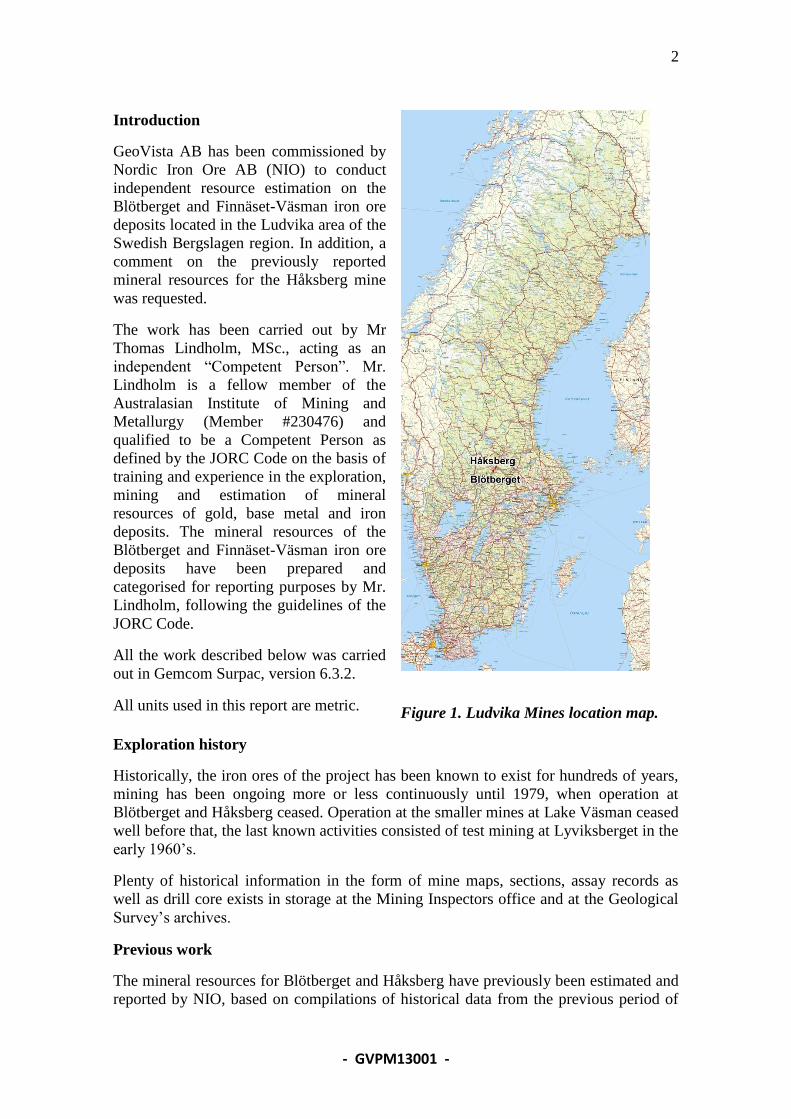
Introduction
GeoVista AB has been commissioned by
Nordic Iron Ore AB (NIO) to conduct
independent resource estimation on the
Blötberget and Finnäset-Väsman iron ore
deposits located in the Ludvika area of the
Swedish Bergslagen region. In addition, a
comment on the previously reported
mineral resources for the Håksberg mine
was requested.
The work has been carried out by Mr
Thomas Lindholm, MSc., acting as an
independent “Competent Person”. Mr.
Lindholm is a fellow member of the
Australasian Institute of Mining and
Metallurgy (Member #230476) and
qualified to be a Competent Person as
defined by the JORC Code on the basis of
training and experience in the exploration,
mining and estimation of mineral
resources of gold, base metal and iron
deposits. The mineral resources of the
Blötberget and Finnäset-Väsman iron ore
deposits have been prepared and
categorised for reporting purposes by Mr.
Lindholm, following the guidelines of the
JORC Code.
All the work described below was carried
out in Gemcom Surpac, version 6.3.2.
All units used in this report are metric.
Figure 1. Ludvika Mines location map.
Exploration history
Historically, the iron ores of the project has been known to exist for hundreds of years,
mining has been ongoing more or less continuously until 1979, when operation at
Blötberget and Håksberg ceased. Operation at the smaller mines at Lake Väsman ceased
well before that, the last known activities consisted of test mining at Lyviksberget in the
early 1960’s.
Plenty of historical information in the form of mine maps, sections, assay records as
well as drill core exists in storage at the Mining Inspectors office and at the Geological
Survey’s archives.
Previous work
The mineral resources for Blötberget and Håksberg have previously been estimated and
reported by NIO, based on compilations of historical data from the previous period of
3
- GVPM13001 -
mining activities. The reported resources have later been confirmed and reported by
GeoVista AB based on a campaign of re-logging and re-assaying historical drill core.
Approximately 5130 m of drill core from the Blötberget mine, 1300 m from Håksberg
and 1430 m from the Väsman area have, so far been re-logged and re-assayed for
confirmatory purposes. Historical core is stored at the Geological Survey core
repository in Malå, all logging was carried out at their premises.
The results of this campaign of re-logging and re-assaying has been reported earlier by
GeoVista, in summary they confirm the usability of the historical material.
Current exploration program
The current exploration program has been aimed both at investigating the assumed
down-dip extensions of Kalvgruvan and Flygruvan at Blötberget and to investigate the
strong magnetic anomalies located under Lake Väsman. NIO has earlier reported an
Exploration Target of 600-650 Mt with 28-30% Fe in magnetite for this area.
The drilling at Blötberget has managed to extend the interpretation of Kalvgruvan and
Flygruvan further down-dip.
The results from the drilling programme at Lake Väsman confirm the magnetic survey
work carried out by the SGU and NIO, that the mineralised zones of the Håksberg
mining camp continues under the lake all the way down to the south shore of the lake to
Finnäset.
The investigation under the lake has necessitated drilling long, gently dipping holes
from the eastern shore as well as from a barge towed to location and anchored on the
lake.
Current drilling, core handling, sample preparation and assaying
The most recent drilling was carried out by the Swedish contractor Drillcon Core AB, or
by their Finnish subsidiary Suomen Malmi Oy, using wireline 56, recovering 39 mm
drill core. Two holes have been drilled for metallurgical sampling, using HQ dimension
to recover 63.5mm core. Eight of the holes (2883m) have been drilled with oriented
core to provide better structural information. Six of the holes have been subject to test
pumping to provide information on the potential for water bearing fracture zones.
All core has been kept at the drill rigs until recovered by NIO technicians or geologists
and transported to the core logging facility in Grängesberg.
NIO staff has logged the core using industry practice routines as established in NIO’s
Quality Manual. This includes core recovery, RQD, lithological logging and
photography (wet and dry). In addition, core has been tested for point load to assess
rock mechanical properties. Oriented core has been use to give 3D information on joint
sets.
The geologist marked the assay section on to the core box as well as on the core and
inserted a sample ticket in the core box before the core was split by diamond sawing.
4
- GVPM13001 -
Split core was dried and put in plastic bags together with the sample ticket. The bag was
again marked with the sample ID and sealed with cable ties. Samples were transported
by Bussgods to ALS facility in Piteå for crushing and milling.
Ampoules of approximately 250g of ground sample pulp were then forwarded for
assaying.
The assays have been carried out by ALS Global in Vancouver, using either of ME-
XRF11b, ME-XRF15b or ME-XRF21n, depending on when in time they were done and
whether they were suspected of containing larger amounts of sulphide minerals or not.
All three methods are considered appropriate for iron ore projects.
Bulk density determination and density assignments
The bulk density has been determined for most assay sections, using Archimedes
principle of first weighing the sample dry, and then submerged in water.
The densities were determined on split core, with samples weighing approximately
1000g or more, thus giving better representativity of the section and consequently a
smaller spread when plotted against the grade of Fe.
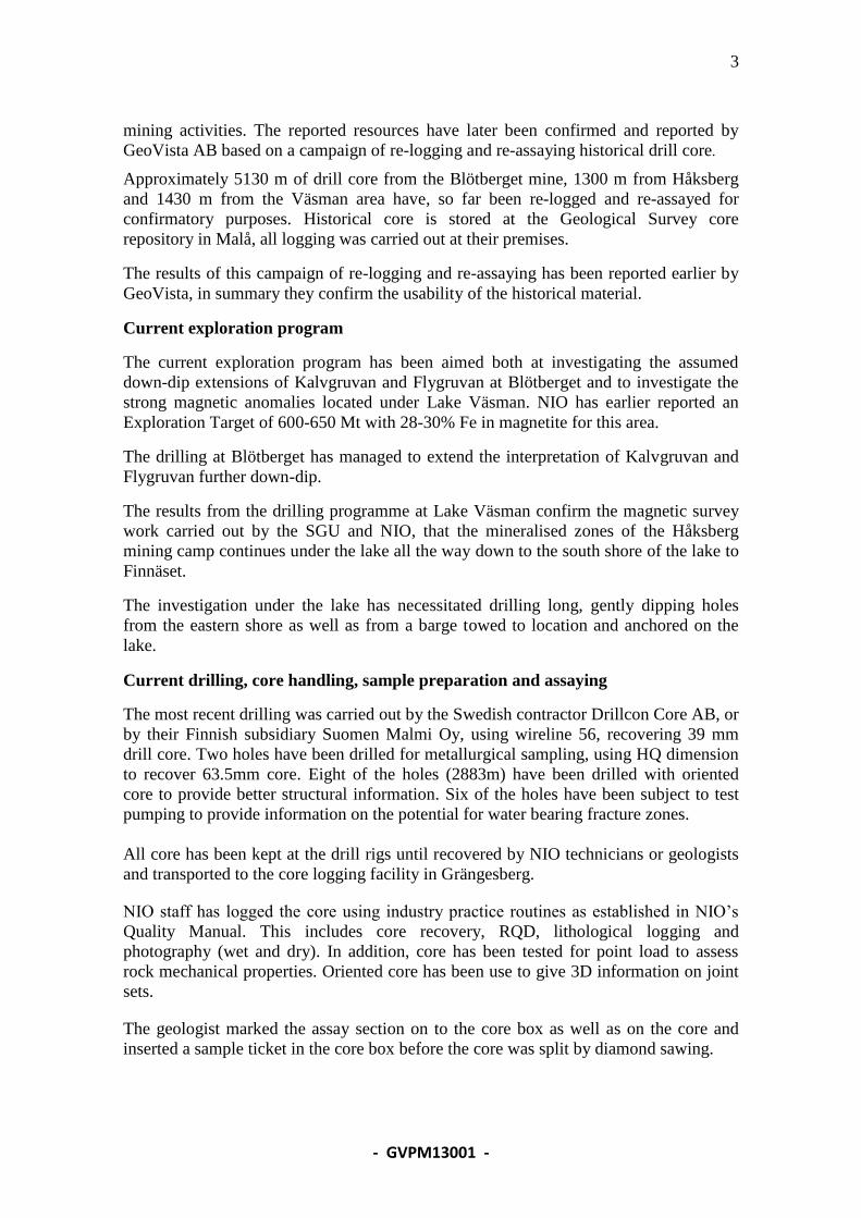
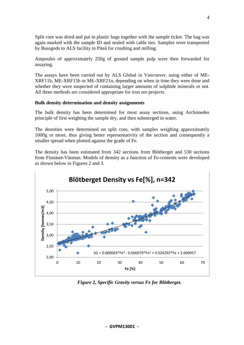
The density has been estimated from 342 sections from Blötberget and 530 sections
from Finnäset-Väsman. Models of density as a function of Fe-contents were developed
as shown below in Figures 2 and 3.
Figure 2, Specific Gravity versus Fe for Blötberget.
SG = 0.000003*Fe3 - 0.000079*Fe2 + 0.026292*Fe + 2.609957 2,00
2,50
3,00
3,50
4,00
4,50
5,00
0 10 20 30 40 50 60 70
De
nsi
ty [
ton
ne
s/m
3]
Fe [%]
Blötberget Density vs Fe[%], n=342
5
- GVPM13001 -
Figure 3, Specific Gravity versus Fe for Väsman.
Data verification
The collar locations as well as initial azimuths for all holes drilled on land have been
surveyed with RTK GPS, giving a precision of +/- 15mm. Holes drilled from the barge
have had the collar location checked with handheld GPS, using stacking of data during
several minutes, to get good positional data.
QA/QC
Samples for quality assurance and quality control have been inserted, on average, one
every 20 samples. Check samples have consisted of certified standards, blanks and
duplicates of previously assayed samples. No anomalies have been discovered in these
results.
Geological interpretation
Blötberget
The mine field of Blötberget extends 1.2 km in ENE direction. The Kalvgruvan and
Flygruvan (magnetite resp hematite) mineralisation is found in the SW, Hugget, Betsta
(both magnetite and hematite), and Sandell (magnetite) in NE. The sedimentary ore
horizons are thickest in the SW, on average 20-25m in Kalvgruvan and Flygruvan,
while 5-10m thick in NE in Hugget/Betsta. The ore horizon is irregularly interlayered
by pegmatite and mafic dikes. Dip at the surface is 50-55 degrees, further down the ore
bodies are flattening to approximately 25 degrees at 500 below the surface.
SG = 0.000008*Fe3 - 0.000623*Fe2 + 0.039447*Fe + 2.592202 1,90
2,40
2,90
3,40
3,90
4,40
4,90
0 10 20 30 40 50 60 70 80
De
nsi
ty [
ton
ne
s/m
3]
Fe [%]
Finnäset-Väsman Density vs Fe[%], n=530
6
- GVPM13001 -
The interpretation of the mineralised zones are therefore based on the geological
models, but applying a 20% Fe cut-off grade for defined mineable sections (generally
assumed to be a minimum of 6m thick).
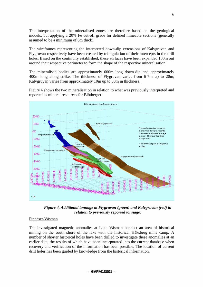
The wireframes representing the interpreted down-dip extensions of Kalvgruvan and
Flygruvan respectively have been created by triangulation of their intercepts in the drill
holes. Based on the continuity established, these surfaces have been expanded 100m out
around their respective perimeter to form the shape of the respective mineralisation.
The mineralised bodies are approximately 600m long down-dip and approximately
400m long along strike. The thickness of Flygruvan varies from 6-7m up to 20m;
Kalvgruvan varies from approximately 10m up to 30m in thickness.
Figure 4 shows the two mineralisation in relation to what was previously interpreted and
reported as mineral resources for Blötberget.
Figure 4, Additional tonnage at Flygruvan (green) and Kalvgruvan (red) in
relation to previously reported tonnage.
Finnäset-Väsman
The investigated magnetic anomalies at Lake Väsman connect an area of historical
mining on the south shore of the lake with the historical Håksberg mine camp. A
number of shorter historical holes have been drilled to investigate these anomalies at an
earlier date, the results of which have been incorporated into the current database when
recovery and verification of the information has been possible. The location of current
drill holes has been guided by knowledge from the historical information.
7
- GVPM13001 -
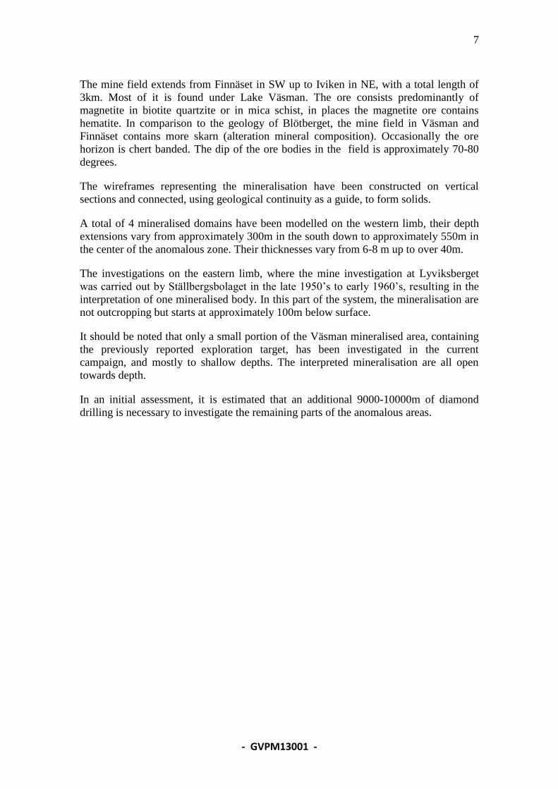
The mine field extends from Finnäset in SW up to Iviken in NE, with a total length of
3km. Most of it is found under Lake Väsman. The ore consists predominantly of
magnetite in biotite quartzite or in mica schist, in places the magnetite ore contains
hematite. In comparison to the geology of Blötberget, the mine field in Väsman and
Finnäset contains more skarn (alteration mineral composition). Occasionally the ore
horizon is chert banded. The dip of the ore bodies in the field is approximately 70-80
degrees.
The wireframes representing the mineralisation have been constructed on vertical
sections and connected, using geological continuity as a guide, to form solids.
A total of 4 mineralised domains have been modelled on the western limb, their depth
extensions vary from approximately 300m in the south down to approximately 550m in
the center of the anomalous zone. Their thicknesses vary from 6-8 m up to over 40m.
The investigations on the eastern limb, where the mine investigation at Lyviksberget
was carried out by Ställbergsbolaget in the late 1950’s to early 1960’s, resulting in the
interpretation of one mineralised body. In this part of the system, the mineralisation are
not outcropping but starts at approximately 100m below surface.
It should be noted that only a small portion of the Väsman mineralised area, containing
the previously reported exploration target, has been investigated in the current
campaign, and mostly to shallow depths. The interpreted mineralisation are all open
towards depth.
In an initial assessment, it is estimated that an additional 9000-10000m of diamond
drilling is necessary to investigate the remaining parts of the anomalous areas.
8
- GVPM13001 -
Figure 5, Mineralised zones at Finnäset-Väsman
Mineral resource estimates
The mineral resources for Blötberget have been reported previously, the current report
is focussed on reporting the additional resources, which have been encountered in the
current drill campaign.
No recent attempts have been made to estimate the resources at Finnäset-Väsman before
the current one.
Usable variograms for the deposits could not, as yet, be developed, the interpolation is
therefore carried out using Nearest Neighbour, in combination with search parameters
based on the authors’ experience.
9
- GVPM13001 -
The search ellipses were oriented in parallel with the strike and dip of the mineralised
lenses.
The length of the recent assay sections is variable, but in general 2m. All sections have
been composited to 5m length before being used in the evaluation of the deposits.
Block models
Blötberget
A block model was developed for the Flygruvan-Kalvgruvan mineralisation at
Blötberget. The block model utilises regularly shaped blocks measuring 20*20*5m
(X*Y*Z). The block sizes are judged to be the most appropriate considering the
geometry of the mineralisation, the distribution of sample information as well as the
expected size of the mining blocks. To better conform to the mineralisation’s contacts,
sub-blocking down to ¼ side length was used. The block model is not rotated. Block
grades were estimated for parent cells and distributed to their sub-blocks. Block model
grade interpolation was performed using Nearest Neighbour, with a maximum search
radius of 225m.
Each mineralised domain (Flygruvan and Kalvgruvan respectively) has been
interpolated using samples/composites only from within it.
The block model validation includes a visual inspection of block grades versus
composite values on vertical sections. This did not show any deviations when compared
with the grades from the drill holes across sections.
The distribution of block values was compared to the distribution of composite values
and found to have reasonable similarities.
Finnäset-Väsman
One block model was developed for the mineralisation encountered at the western limb
at Finnäset-Väsman. The block model utilises regularly shaped blocks measuring
10*25*25m (X*Y*Z). The block sizes are judged to be the most appropriate
considering the geometry of the mineralisation, the distribution of sample information
as well as the expected size of the mining blocks. To better conform to the
mineralisation’s contacts, sub-blocking down to ¼ side length was used. The block
model is rotated, with its orientation N40°E, to better conform to the orientation of the
mineralisation. Block grades were estimated for parent cells and distributed to their sub-
blocks. Block model grade interpolation was performed using Nearest Neighbour, with
two passes utilizing search radii of 225m and 400m respectively.
Another block model was developed for the mineralisation at Lyviksberget. The block
model utilises regularly shaped blocks measuring 5*20*20m (X*Y*Z). The block sizes
are judged to be the most appropriate considering the geometry of the mineralisation,
the distribution of sample information as well as the expected size of the mining blocks.
To better conform to the mineralisation’s contacts, sub-blocking down to ¼ side length
was used. The block model is rotated, with its orientation N25°E, to better conform to
the orientation of the mineralisation. Block grades were estimated for parent cells and
distributed to their sub-blocks. Block model grade interpolation was performed using
10
- GVPM13001 -
Inverse Distance squared, with three passes utilizing search radii of 75m, 150m and
250m respectively.
Each mineralised domain has been interpolated using samples/composites only from
within it.
The block model for Finnäset-Väsman contains the elements Fe, P and S. For
Lyviksberget, only Fe was modelled.
No top-cut has been applied for the interpolation of Fe, for P a top-cut of 0.1 % was
applied and for S the corresponding value was 0.2%.
The block model validation includes a visual inspection of block grades versus
composite values on vertical sections. This did not show any deviations when compared
with the grades from the drill holes across sections.
The distribution of block values were compared to the distributions of composite values
and found to have reasonable similarities.
Mineral Resource Classification
Mineral resources were estimated following the guidelines of the Australasian Code for
Reporting of Mineral Resources and Ore Reserves prepared by the Joint Ore Reserve
Committee in 2004 (JORC Code, see http://www.jorc.org/). The mineral resources are
summarised in Tables 1 and 2. The following definitions were adopted for the
categorisation of mineral resources:
Measured Mineral Resources
No part of the mineralisation has been classified as Measured Mineral Resources.
Indicated Mineral Resources
For Blötberget, with a typical drill spacing of 100-125m or better, the entire mineral
resource is classified as Indicated based on the demonstrated geological continuity.
For Finnäset-Väsman, only the portion of the denser drilled mineralisation found on
land, at Finnäset, where a typical drilling density of 50-100m was used, would have the
demonstrated geological continuity that merits the classification Indicated.
Inferred Mineral Resources
The mineralisation found under Lake Väsman has been drilled with a density of 100-
200m, all modelled resources have been classified as Inferred mineral resources.
11
- GVPM13001 -
Blötberget Tonnage [Mton] Grade Fe [%] Grade P [%] Grade S [%]
Measured -- -- -- --
Indicated (*) 15.9 46.1
Inferred -- -- -- -- (*)
Combined resources of Flygruvan 7.4 Mton @ 41.4 % Fe and Kalvgruvan 8.5 Mton
@ 50.2% Fe.
Table 1: Mineral Resources at Blötberget, on January 10, 2013.
The mineral resources reported above for Blötberget are in addition to earlier reported
ones, comprising 13.9 Mton Indicated resources at 42.6% Fe and 10.2 Mton Inferred
resources at 42.9% Fe, both reported at 30% Fe cut-off.
Note that the additional resources, currently reported, are based on a 20% Fe cut-off
whereas the previously reported ones are based on a 30% Fe cut-off, they are therefore
not directly comparable.
Finnäset-Väsman Tonnage [Mton] Grade Fe [%] Grade P [%] Grade S [%]
Measured -- -- -- --
Indicated (*) 7.0 38.5 0.07 0.00
Inferred (**) 78.1 38.3 0.05 0.02
Inferred (***) 7.8 39.7 -- -- (*)
Finnäset, land based (**)
Finnäset-Väsman, western limb, all under the lake Väsman
(***) Lyviksberget (Ställbergsbolagen testmine)
Table 2: Mineral Resources at Finnäset-Väsman, on January 10, 2013.
The mineral resource estimate is based upon the following key inputs and assumptions:
1. Mineral resources of the Blötberget and Finnäset-Väsman iron ore deposits have
been prepared and categorised for reporting purposes by Mr. Thomas Lindholm,
MAusIMM, of GeoVista AB, following the guidelines of the JORC Code. Mr
Lindholm is qualified to be a Competent Person as defined by the JORC Code
on the basis of training and experience in the exploration, mining and estimation
of mineral resources of ferrous deposits.
2. The effective date of this statement is January 10, 2013.
3. The Blötberget and Finnäset-Väsman mineral resources are defined primarily by
diamond core drilling. Drilling was conducted on grids with a general density of
100-125m (Blötberget) and 50-100m up to 200m (Finnäset-Väsman).
4. The mineralisation is defined using a cut-off of 20% Fe, permitting the inclusion
internal waste.
5. The mineralisation is modeled into 2 domains for Blötberget and 4 domains for
Finnäset-Väsman.
12
- GVPM13001 -
6. Drill core samples were assayed with XRF by ALS Global. Average sample
section length is 2.0 m. All assay sections have been regularized to 5m
composites using Surpac’s “best fit” option.
7. Block grades were interpolated for all the modeled elements using Nearest
Neighbour with the exception of Lyviksberget, where Inverse Distance squared
was used.
8. Bulk densities of the mineralisation were calculated as a function of the
interpolated grades of Fe.
9. No part of the mineral resources are classified as Measured mineral resources.
10. The mineral resources at Blötberget as well as the Finnäset part of the resources
at Finnäset-Väsman are classified as Indicated mineral resources.
11. The mineral resources found under Lake Väsman are classified as Inferred
mineral resources.
Conclusions and recommendations
There are no indications that the mineralisation at Kalvgruvan and Flygruvan are
terminated at the extent of the current interpretation, further drilling, on strike as well as
down the dip, is therefore recommended. The area in between Kalvgruvan and
Flygruvan and Hugget/Betsta is only briefly investigated, it is considered likely that the
two are connected at depth, and that this needs to be investigated further.
The results achieved so far at Finnäset-Väsman are generally from shallow holes and
the extent of the interpretation towards the depth is consequently conservative. A set of
drill holes to investigate the deeper parts is therefore recommended.
The exploration target previously declared for Lake Väsman has only been briefly
investigated and verified by the program currently reported. Based on these results it is
likely that further investigations will render a huge additional tonnage. In an initial
assessment, it is estimated that an additional 9000-10000m of diamond drilling is
necessary to investigate the remaining parts of the anomalous areas.
References
Larsson M., (2012) Geological Logging and Sampling of Archive Cores at the Central
Core Archive in Malå.
Lindholm T. (2011) GVR11046 Blötberget and Håksberg mineral resource verification.
Recommended