MEDIEVAL AND EARLY
POST-MEDIEVAL MILLS
A THREAT-RELATED ASSESSMENT 2012-14
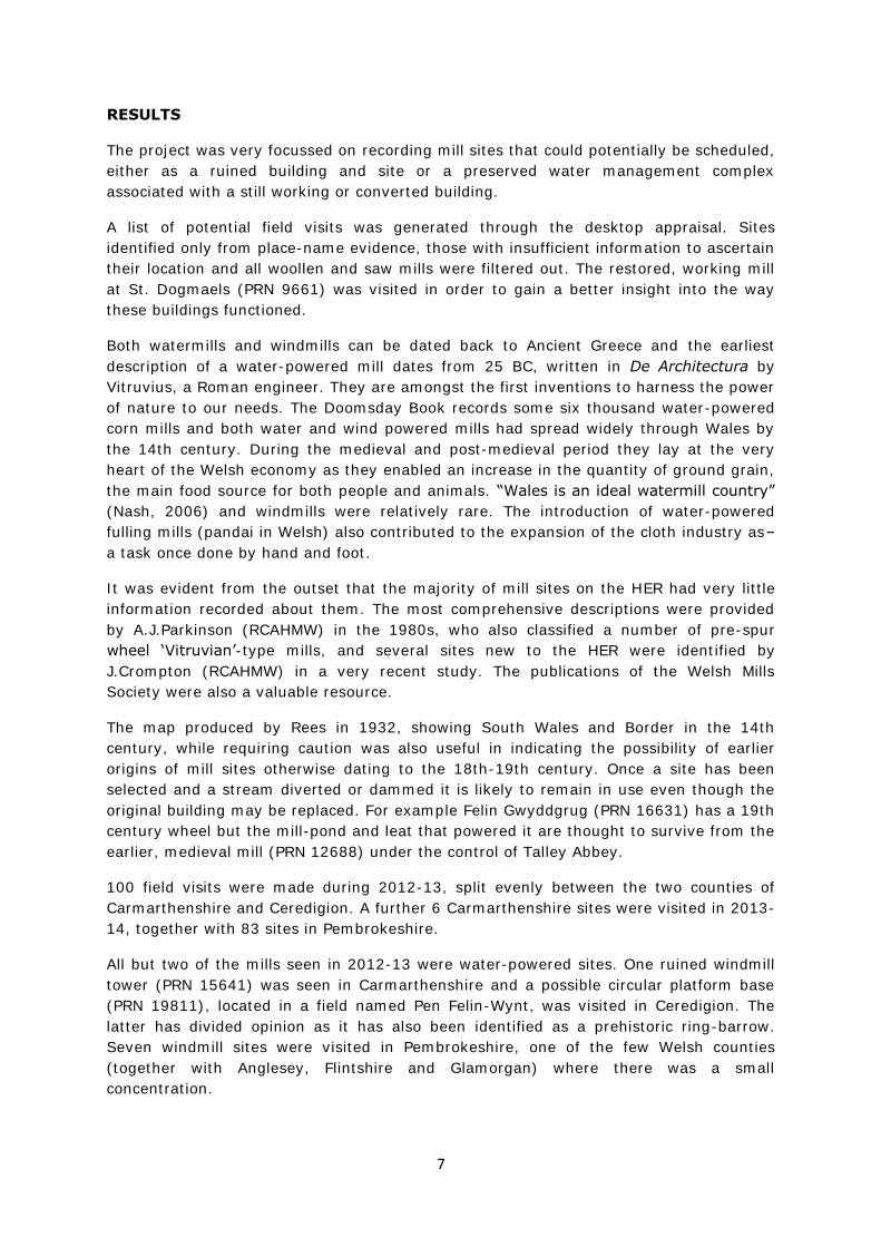
The ruins of an old windmill (PRN 3528) near Carew, Pembrokeshire
Prepared by Dyfed Archaeological Trust
For Cadw

DYFED ARCHAEOLOGICAL TRUST
DAT Event Record No. 102665
Report No. 2014/7
Cadw Project No. DAT 105
March 2014
MEDIEVAL AND EARLY POST-MEDIEVAL MILLS
A THREAT-RELATED ASSESSMENT 2012-14
Gan / By
MIKE INGS
The copyright of this report is held by Cadw and Dyfed Archaeological Trust Ltd.
The maps are based on Ordnance Survey mapping provided by the National Assembly for Wales with
the permission of the Controller of Her Majesty’s Stationary Office, Crown Copyright. All rights
reserved. Unauthorised reproduction infringes Crown Copyright and may lead to prosecution or civil
proceedings. License No.: 100017916 (2014).
Historic mapping reproduced here is covered under Crown Copyright and Landmark Information
Group. All rights reserved. Dyfed Archaeological Trust Ltd. On behalf of Welsh Government 2014.
Ymddiriedolaeth Archaeolegol Dyfed Cyf
Neuadd y Sir, Stryd Caerfyrddin, Llandeilo, Sir
Gaerfyrddin SA19 6AF
Ffon: Ymholiadau Cyffredinol 01558 823121
Adran Rheoli Treftadaeth 01558 823131
Ffacs: 01558 823133
Ebost: [email protected]
Gwefan: www.archaeolegdyfed.org.uk
Dyfed Archaeological Trust Limited
The Shire Hall, Carmarthen Street, Llandeilo,
Carmarthenshire SA19 6AF
Tel: General Enquiries 01558 823121
Heritage Management Section 01558 823131
Fax: 01558 823133
Email: [email protected]
Website: www.dyfedarchaeology.org.uk
The Trust is both a Limited Company (No. 1198990) and a Registered Charity (No. 504616)
CADEIRYDD CHAIRMAN: Prof. B C BURNHAM CYFARWYDDWR DIRECTOR: K MURPHY BA MIFA
CADEIRYDD CHAIRMAN: Prof. B C BURNHAM CYFARWYDDWR DIRECTOR: K MURPHY BA MIFA

MEDIEVAL AND EARLY POST-MEDIEVAL MILLS:
A THREAT-RELATED ASSESSMENT 2012-14
SUMMARY 2
INTRODUCTION 4
PROJECT AIMS AND OBJECTIVES 5
METHODOLOGY 6
RESULTS 7
REFERENCES 10
GAZETTEER

1

2
MEDIEVAL AND EARLY POST-MEDIEVAL MILLS:
A THREAT-RELATED ASSESSMENT 2012-14
SUMMARY
The medieval and post-medieval mills project forms an element of the Cadw grant-aided
medieval and post-medieval threat related assessment project.
A desk-based scoping project aimed to identify all the medieval and early post-medieval
water-power and mill sites on the Historic Environment Record (HER), providing an
indication of total numbers, numbers of sites represented by documents or place-names
and which sites are scheduled.
The initial primary sorting exercise identified a list of 888 possible mill sites and 594
potential water-management sites. It was noted that the vast majority of the sites on
the HER were recorded as ‘Mill’, with no indication of its function or source of power. It
was also clear that dating these mills was problematic as, although the building may be
recorded as 19th century, the site may have much older, possibly medieval, origins and
elements of this earlier phase may survive.
The number of water-management sites may be inflated by multiple records pertaining
to the same complex. Also, many of the recorded leats reservoirs, dams etc may not be
associated with mills but with metal mines and similar sites.
The preliminary project sought to cut the number to include only those that may have
the potential to be scheduled, filtering out any that had effectively been destroyed or
where the mill building survived, either as a working mill or converted, but nothing or
little of the ancillary features such as leats and ponds remain. The total number of sites
was reduced from some 1500 to 572.
It was estimated that of these 572 sites there were approximately 250 individual mill
sites requiring further investigation. Additional sites were added during the course of the
project, resulting in 260 sites identified worthy of further investigation. Dossiers on these
260 sites were prepared, with a view to visiting 150-200 of them across the three
counties of Carmarthenshire, Ceredigion and Pembrokeshire. An interim report (Report
number 2013/28) was produced in April 2013 that covered the mill sites assessed and
visited within Carmarthenshire and Ceredigion during 2012-13. Sites in Pembrokeshire,
together with several more in Carmarthenshire, were visited in 2013-14. This report now
includes all sites assessed and visited during the survey.
189 sites have been visited. Of these, 114 were near destroyed or ruinous. 56 were near
intact, restored and/or converted and the remainder were either damaged (8), not found
(4) or seen to be cottages or dwellings rather than mills (7). Scheduling and listing
recommendations have been sent to Cadw, together with details of sites that would
benefit from further survey.

3
4
INTRODUCTION
In 2010, Dyfed Archaeological Trust undertook a Cadw grant-aided scoping study of
medieval and post-medieval sites and landscapes (Davis 2010), part of a pan-Wales
project (undertaken by all four Welsh Archaeological Trusts). The aim of the study was
to identify all medieval and post-medieval sites recorded on the HER that have not been
the subject of a previous threat-related assessment and to categorise them by site type.
‘Mill’ and ‘Water power’ were two of the site types identified..
The primary sorting exercise identified the following site types within the HER:
Mill (458) Mill Race(67)
Windmill (23) Leat (260)
Windmill/Mill (1) Leat/Ditch (7)
Water Mill (147) Mill Pond (26)
Fulling Mill/Corn Mill (10) Aqueduct (37)
Corn Mill (132) Mill Race/ Mill Pond (1)
Woollen Mill/Corn Mill (3) Mill Race/ Mill Pond/ Leat (1)
Saw Mill/Corn Mill (3) Water Wheel (4)
Woollen Mill/Fulling Mill(3) Waterwheel (5)
Woollen Mill/Mill (1) Water Channel (25)
Flour Mill (1) Pond/dam (1)
Saw Mill (32) Weir (12)
Mill/Dwelling (2) Reservoir/ Dam (3)
Mill/Cottage (2) Reservoir (66)
Dam (30) Pond (49)
Due to the large number of mill sites it was decided, during the secondary sorting
exercise, to analyse a sample of 20 using the HER and secondary sources to gain an
overall impression of the available information. This sample highlighted the problem with
dating the construction and use of these sites. It was also noted that, although many
mills have been converted, a number of archaeological features may still be preserved
including water-management complexes and original machinery. The quality of the
sources in the HER was found to be mixed, with the majority of sampled sites having no
or only one recorded source.
Records held at the RCAHMW, particularly the work by Tony Parkinson, and on their
Coflein website were very useful for additional information.
Acting on the results of the scoping study, the Trust applied to Cadw for grant-aid to
undertake a threat-related assessment of Mill sites in southwest Wales
(Carmarthenshire, Ceredigion and Pembrokeshire). This application was successful and
the project, including fieldwork, was undertaken in 2012-14.
5
PROJECT AIMS AND OBJECTIVES
The main aim of this project is to use the HER, National Monument Record, secondary
sources and field visits to assess the potential for enhancing the schedule of ancient
monuments with medieval or early post-medieval mill sites.
The overall project’s aims are:
• An application of definition, classification, quantification and distribution of these
sites in Wales.
• Assessment of the archaeological significance of mills in both a regional and
national perspective.
• Assessment of the vulnerability of this element of the archaeological resource,
review of scheduling, and recommendations for future management strategies.
• Enhancement of the regional HER and Extended National Database.
The project’s objectives are:
• To identify all mills which require further assessment;
• To collate existing documentary evidence for the sites;
• To carry out a field assessment of those sites where necessary;
• To incorporate all the information into a database and enhance the Dyfed HER;
and
• To advise Cadw on those sites which are of national value and currently without
statutory protection.
6
METHODOLOGY
The scoping study collated a list of sites that could potentially require a desk-top
appraisal and possible field visit. This ‘snapshot’ of the data held within the Dyfed HER
was filtered to accept all ‘Mill’ and ‘Water power’ sites of medieval and post-medieval
date; and all sites of unknown date. The resulting record was further filtered to remove
sites that:
Are effectively destroyed
Survive as complete buildings, either working mills or converted, but nothing or
little of ancillary features, such as leats and ponds, remain.
Comprise only a surviving leat
Sites that possessed the following criteria, ranked in potential importance, were
included:
Mill building reduced to an earthwork/ruin and site now abandoned with no
evidence of post-abandonment re-use.
Mill building reduced to a ruin or disused with no extensive modern development
close by (ie, large agricultural buildings), and an ancillary feature such as a leat
or pond survive, or have the potential to survive.
Mill building in use (either as a mill or converted) but a range of ancillary
features such as leats and ponds survive, or have the potential to survive.
Using the above criteria all mill sites, possible mill sites, leats, water wheels etc. were
assessed. The total number of sites was reduced from some 1500 to 572. This included
site types ‘Water Mill’ (147 sites) and ‘Fulling Mill (58 sites), both of which are mainly
only known through documentary evidence (mostly medieval) and there precise
locations are unknown. It is likely that many of these sites are duplicates of other site
types for which more accurate geographic data is available. In addition, many mill sites
include more than one record, incorporating the building, race, pond etc, indicating that
the number of individual mill sites is approximately 250.
The desktop appraisal collated all the available information on each site as held in the
Dyfed Archaeological Trust Historic Environment Record (HER). This included reference
to the 1st and 2nd edition Ordnance Survey maps, tithe maps, SAM and Listed Building
records, Ordnance Survey record cards, Royal Commission inventories and archived
reports.
The records held by the Royal Commission for Historic Buildings and Monuments of
Wales (RCAHMW) were consulted, including recent work conducted in Ceredigion by John
Crompton, and their Coflein website was utilised.
260 dossiers were compiled and field visits were made to 100 mill sites in
Carmarthenshire and Ceredigion during 2012-13. The results of this work were
presented in an interim report (Report no. 2013/28) produced in April 2013. Field visits
were then made during 2013-14 to 83 sites in Pembrokeshire and a further 6 sites in
Carmarthenshire.
7
RESULTS
The project was very focussed on recording mill sites that could potentially be scheduled,
either as a ruined building and site or a preserved water management complex
associated with a still working or converted building.
A list of potential field visits was generated through the desktop appraisal. Sites
identified only from place-name evidence, those with insufficient information to ascertain
their location and all woollen and saw mills were filtered out. The restored, working mill
at St. Dogmaels (PRN 9661) was visited in order to gain a better insight into the way
these buildings functioned.
Both watermills and windmills can be dated back to Ancient Greece and the earliest
description of a water-powered mill dates from 25 BC, written in De Architectura by
Vitruvius, a Roman engineer. They are amongst the first inventions to harness the power
of nature to our needs. The Doomsday Book records some six thousand water-powered
corn mills and both water and wind powered mills had spread widely through Wales by
the 14th century. During the medieval and post-medieval period they lay at the very
heart of the Welsh economy as they enabled an increase in the quantity of ground grain,
the main food source for both people and animals. “Wales is an ideal watermill country”
(Nash, 2006) and windmills were relatively rare. The introduction of water-powered
fulling mills (pandai in Welsh) also contributed to the expansion of the cloth industry as–
a task once done by hand and foot.
It was evident from the outset that the majority of mill sites on the HER had very little
information recorded about them. The most comprehensive descriptions were provided
by A.J.Parkinson (RCAHMW) in the 1980s, who also classified a number of pre-spur
wheel ‘Vitruvian’-type mills, and several sites new to the HER were identified by
J.Crompton (RCAHMW) in a very recent study. The publications of the Welsh Mills
Society were also a valuable resource.
The map produced by Rees in 1932, showing South Wales and Border in the 14th
century, while requiring caution was also useful in indicating the possibility of earlier
origins of mill sites otherwise dating to the 18th-19th century. Once a site has been
selected and a stream diverted or dammed it is likely to remain in use even though the
original building may be replaced. For example Felin Gwyddgrug (PRN 16631) has a 19th
century wheel but the mill-pond and leat that powered it are thought to survive from the
earlier, medieval mill (PRN 12688) under the control of Talley Abbey.
100 field visits were made during 2012-13, split evenly between the two counties of
Carmarthenshire and Ceredigion. A further 6 Carmarthenshire sites were visited in 2013-
14, together with 83 sites in Pembrokeshire.
All but two of the mills seen in 2012-13 were water-powered sites. One ruined windmill
tower (PRN 15641) was seen in Carmarthenshire and a possible circular platform base
(PRN 19811), located in a field named Pen Felin-Wynt, was visited in Ceredigion. The
latter has divided opinion as it has also been identified as a prehistoric ring-barrow.
Seven windmill sites were visited in Pembrokeshire, one of the few Welsh counties
(together with Anglesey, Flintshire and Glamorgan) where there was a small
concentration.
8
One listed windmill, at Windmill Farm (PRN 16468) above Dale, was viewed as a useful
comparison to the several undesignated sites visited. The full circumference of the
tower, which still stands some 6-7 metres high, survives. Of the seen sites, only the old
windmill (PRN 15819) at Gelliswick was similarly preserved and now stands within a
private garden. The windmill towers at Crabhall Farm near Dale (PRN 2975), near Carew
(PRN 3528), Bosherston (PRN 26367) and at Tarr Farm, Manorbier (PRN 33716) are now
less complete. No structural remains of Middle Mill (PRN 33717), to the east of
Manorbier, were evident.
New uses have been found for several redundant windmills. These include two Grade II
listed buildings; Twr Y Felin (PRN 4344) has now been incorporated into a hotel at St.
David’s and the old windmill at Angle (PRN 4386) was adapted to serve as a WW2
machine-gun post. The site at Tarr Farm (PRN 33716) is referred to by locals as ‘the
dovecote’, suggesting another change in function, while Pen Felin-Wynt (PRN 35603),
near Rosebush, is believed to have been used to pump water for water wagons and
steam engines in a quarry (Johns, 1995).
Of the water-powered mills, the mill building itself was just a single element of a
complex that could include a mill-race, tail-race, holding pond, weir and sluices. When
these mills were working the mill-race, and a yard either side, would be under the
ownership of the miller and it could often stretch for quite a distance. Today, these
features often run across land owned by different farmers and several mills visited,
although appearing potentially functional, have had their lifeline cut off by way of a
blocked or in-filled mill-race. For example, Felin Cwm (PRN 21370), near Rhydlewis in
Ceredigion, retains much of its machinery but the dam diverting the mill-race from the
river, now on neighbouring land, has now been flattened. Water-management features
were explored where possible, although access wasn’t always possible either through
ownership issues or heavy undergrowth.
Two sites seen had no surviving mill building at all but the mill-race and/or holding pond
were preserved, including the extensive leat (PRN 41) that once powered the Priory Mill
in Carmarthen.
88 of the visited mills are now ruinous. They are usually located in wooded stream
valleys and many have proved difficult to access. These are the most vulnerable sites as
they are being damaged further by encroaching vegetation and falling branches. A good
example is Felin Gwm (PRN 16626), by the Afon Gilwydeth in Ceredigion where fallen
trees have demolished the façade and an arched window which were photographed as
complete in 2004.
Several highly ruinous mills are located on the coastal edges, including Greatmire Mill
(PRN 32632) in Pembrokeshire and Marros Mill (PRN 11656) in Carmarthenshire. These
sites are quickly being eroded away and it is recommended that they are
comprehensively recorded before being lost completely.
A further 8 sites have been identified as ‘damaged’. These are preserved in a better
state of repair and have often been re-roofed, normally with corrugated-tin. These mills
were usually found to be being used for storage but, again, they are vulnerable as the
cost of maintaining and/or restoring old buildings is often onerous, potentially resulting
in further deterioration and possible eventual collapse.
9
56 of the visited mills were near intact or restored, and 32 of them have now been
converted to domestic use. Not all the converted mills were recorded as such on the HER
and this new information is useful for monitoring their preservation and management.
The majority also had surviving water-management features and many had retained
other elements from the mill, including several mill stones set as garden ornaments.
Felin Pen-yr-allt (PRN 15351), in Banc-y-felin, Ceredigion, has a slate ramp to a first-
floor doorway that was used to load grain sacks.
26 of the sites are now all but totally destroyed, either with no visible remains or
surviving as earthworks. Generally these have been confirmed by the landowners to
have disappeared before living memory and further, more detailed survey work may be
applicable to gain a better understanding of them. When visiting the earthwork remains
of Llanon corn mill (PRN 105366) a local resident showed me a photograph
(undated/?early C20th) of the mill, complete and still working. The majority of these
sites are currently stable beneath pasture but could be considered vulnerable to any
change in agricultural regime.
The majority of the sites included in this survey are mills for grinding corn or for fulling.
However, two mills visited in Pembrokeshire were gorse mills, used to provide fodder for
livestock. Purpose-built, water-powered gorse mills had been devised by the mid-18th
century, revolutionising “the tedious and time-consuming task of processing gorse”
(Nash, 2003). In Wales, there were concentrations of such mills in Caernarfonshire and
Pembrokeshire. Old Mill (PRN 17957), at Upper Eweston Farm, Pen-y-cwm, is typical of
such mills in the area, being small (approximately 5m sq.), single-storeyed and built into
a bank. Melin Treginnis (PRN 16176), on the coast, southwest of St. David’s, is far more
ruinous. Such mills had largely disappeared by the end of the 19th century.
Additionally, a paper mill was visited, just to the north of Haverfordwest. Prendergast
(PRN 8777) was one of several paper mills in the area recorded in the 18th century and
the last to survive. It was originally built as a cotton mill in 1766, converting to paper
manufacturing by 1791. The building became derelict between the two world wars.
Of the remaining visited sites, two cannot really be described as mills as they are water-
wheels erected to drive threshing machinery rather than for grinding corn. Six sites were
visited because their place-name indicated them to be probable mills – Old Mill (PRN
16497), Felin Saint (PRN 18957), Felin-fach-uchaf (PRN 19075), Hen Felin (19076),
Maes y Felin (PRN 28370) and Felin-fach-ganol (PRN 105990) – but the field visits
identified them as cottages. Possibly these once belonged to a mill-owner or a mill
formerly stood on/near the site. Two sites, Felin Newydd (PRN 16944) and Slouth corn
mill (PRN 46897) could not be found at the recorded locations.
Several new sites came to our attention during the course of the survey, through the
work of other historians, from the general public – an article on the project was
published in the Carmarthen Journal in August 2012, which generated a good response –
or from work on other projects, such as the Glastir Woodland polygons project of 2013.
As a result of the field visits,, across all three counties. 38 sites have been recommended
to Cadw for possible legal protection through either scheduling or listing. A further 18
sites have been recommended for further survey work, again with a possible view to
affording them possible legal protection in the future.
10
REFERENCES
Davis, O., 2010, Medieval and Post-Medieval Sites and Landscapes: Scoping Report,
unpublished report by Dyfed Archaeological Trust, Report no. 2011/52
Ings, M., 2013, Medieval and Early Post-Medieval Mills: A threat-related assessment
2012-13, Interim report, Report no. 2013/23
Johns, B., 1995, Pembrokeshire Past and Present
Nash, G.D., 2003, ‘Gorse and Gorse Mills in Wales’, Melin 19 – Journal of the Welsh Mills
Society
Nash, G.D., 2006, ‘The Windmills of Ceredigion and Carmarthenshire’, Melin 22 – Journal
of the Welsh Mills Society
Watts,M.W., 2006, Watermills


GAZETTEER OF SITES

CARMARTHENSHIRE
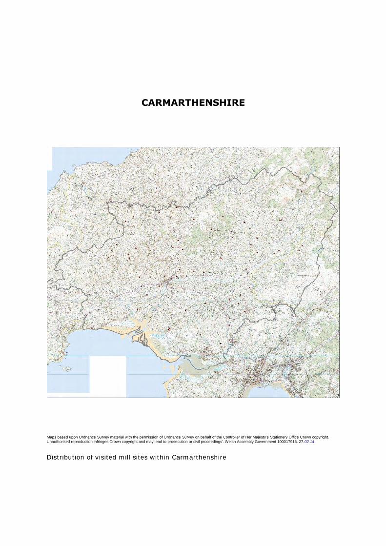
Maps based upon Ordnance Survey material with the permission of Ordnance Survey on behalf of the Controller of Her Majesty's Stationery Office Crown copyright. Unauthorised reproduction infringes Crown copyright and may lead to prosecution or civil proceedings'. Welsh Assembly Government 100017916. 27.02.14
Distribution of visited mill sites within Carmarthenshire
PRN 41
NAME PRIORY WATERCOURSE TYPE MILL RACE PERIOD Medieval
FORM Earthwork CONDITION various STATUS None recorded
NGR SN42202081 COMMUNITY Carmarthen COUNTY Carmarthenshire
HER DESCRIPTION
A mill race providing water for the Priory Mills (PRN 42). The watercourse started from
the River Gwili at Bronwydd, following natural contours along a man-made ditch. The
exact date of its construction is unknown but the mills are first mentioned in the taxatio
of 1291. (PP 4/11/04)
The mill-race was recorded during the Cadw funded Mills Survey of 2012-14. It is
diverted from the Afon Gwili to the north of Carmarthen and a public footpath runs
alongside it for most of its course. It ranges in character from a substantial, in parts 4m
wide at base, steeply cut earthwork to a much narrower, shallower channel, some 1.5 -
3.0m wide at base. A construction bank runs along the eastern side of the race and, for
some stretches, the footpath appears to run along the top of it. The race still carries
water between the river and Dolgwili Road. Its course appears to be lost to the south of
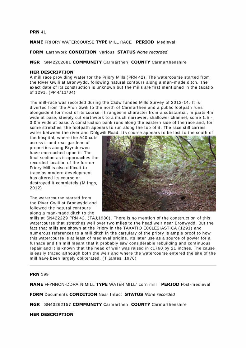
the hospital, where the A40 cuts
across it and rear gardens of
properties along Brynderwen
have encroached upon it. The
final section as it approaches the
recorded location of the former
Priory Mill is also difficult to
trace as modern development
has altered its course or
destroyed it completely (M.Ings,
2012)
The watercourse started from
the River Gwili at Bronwydd and
followed the natural contours
along a man-made ditch to the
mills at SN422229 PRN 42. (TAJ,1980). There is no mention of the construction of this
watercourse that stretches well over two miles to the head weir near Bronwydd. But the
fact that mills are shown at the Priory in the TAXATIO ECCLESIASTICA (1291) and
numerous references to a mill ditch in the cartulary of the priory is ample proof to how
this watercourse is at least of medieval origins. Its later use as a source of power for a
furnace and tin mill meant that it probably saw considerable rebuilding and continuous
repair and it is known that the head of weir was raised in c1760 by 21 inches. The cause
is easily traced although both the weir and where the watercourse entered the site of the
mill have been largely obliterated. (T James, 1976)
PRN 199
NAME FFYNNON-DDRAIN MILL TYPE WATER MILL/ corn mill PERIOD Post-medieval
FORM Documents CONDITION Near Intact STATUS None recorded
NGR SN40262157 COMMUNITY Carmarthen COUNTY Carmarthenshire
HER DESCRIPTION
Ffynnon-ddrain corn mill is recorded on the 1890 1st edition and 1906 2nd edition
Ordnance Survey maps, with an elongated mill pond located behind the building fed by a
mill race diverted from the river to the north (M.Ings, 2013)
The site was visited during the Cadw funded Mills Survey of 2012-14. The mill building is
adjoined to the main house, in the southeast corner of a farmstead complex. It is intact
and under a slate roof. The southwest-facing facade has been rendered and has a single-
storey extension attached. The southeast facing sidewall is still of exposed stone rubble
and the iron frame of a waterwheel still stands within its wheel-pit. Unfortunately the
interior could not be viewed and the rear wall of the mill was inaccessible. The mill race
could be traced to the north of the farmstead as a distinct earthwork, running along the
contour of a steep slope through woodland (M.Ings, 2013)
PRN 254
NAME FELIN DRYSGEIRCH TYPE Corn mill PERIOD Post-medieval
FORM Building CONDITION Near Intact STATUS listed building 82285
NGR SN4599112351 COMMUNITY Llangyndeyrn COUNTY Carmarthenshire
HER DESCRIPTION
Grade II listed mill with machinery still preserved, including an overshot waterwheel
(M.Ings, 2013)
The mill was seen during the Cadw funded Mills Survey of 2012-14. It is a three-storey,
gable-ended building of stone rubble with squared quoins and a slate roof. There
appears to be a possible 'lean-to' stone extension to the rear of the mill. The iron frame
of the waterwheel is still in situ within the wheel-pit adjacent to the east-facing gable,
with the axle inserted through the wall. The windows on the facade and gable ends are
stone-arched. The interior of the building could not be seen, although the limited view
through one of the front windows revealed the preserved hurst frame and some of the
gearing. A neighbour said that he thought at least two pairs of mill stones were still
present (M.Ings, 2013)
A three-storey building with some of the machinery still in position. The iron mill wheel
still remains in position. The mill race can be seen and originates at Felindre farm where
it is fed by spring. (ER Evans, 1983)
PRN 4712
NAME FELIN FFOREST; FOREST HILL WATER MILL; FOREST HILL
SMITHY TYPE MILL PERIOD Post-medieval
FORM Building CONDITION Near Intact/ Converted STATUS None recorded
NGR SN57770437 COMMUNITY Llanedi COUNTY Carmarthenshire
HER DESCRIPTION
Site of a corn mill that dates from at least the 17th century, when it is recorded in a
survey of the Duchy of Lancaster Lordships in Wales (1609-1613). It is possible that it
stands at the same location as a medieval watermill (PRN 12699) depicted on Rees'
(1932) map of South Wales and Border in the 14th century. The site is recorded on the
1906 2nd edition Ordnance Survey map with an associated weir (PRN 102939), sluice,
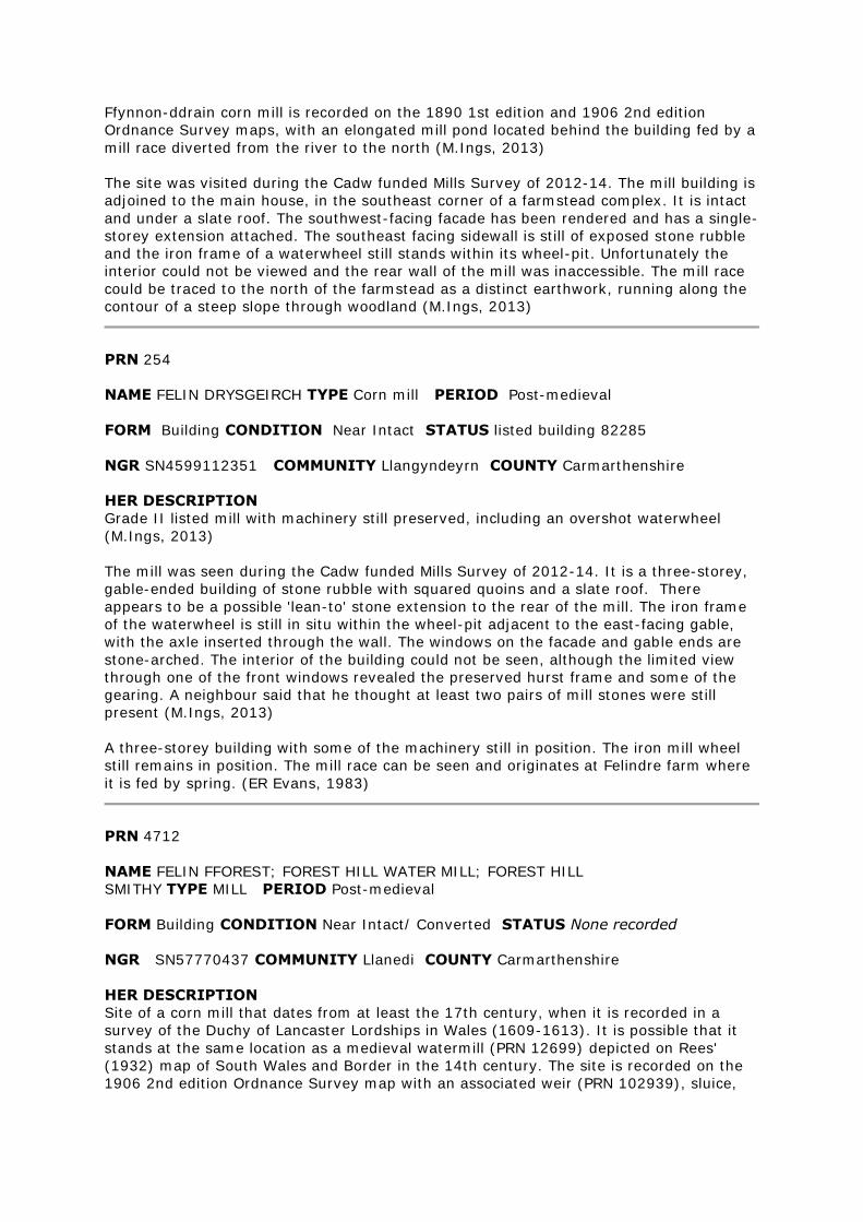
mill-race (PRN 102938) and mill-
pond (PRN 102937) (M.Ings, 2012,
from various sources)
The site was visited during the
Cadw funded Mills project of 2012-
14. The mill itself, a two-storey,
gable-ended stone building with a
slate roof, has been restored and
converted. The current owners
showed me a pre-1902 photograph
depicting the mill complete with a
wooden waterwheel. The wheel-pit
is preserved but the wheel is now
gone, and the mill wall has been
infilled with bricks where it was once affixed. Four millstones survive, positioned around
the garden. The weir on the Afon Gwili, where water is diverted into the mill-race, is still
intact and comprises undressed stones and pebbles of varying sizes bonded together.
The entrance to the mill-race was also evident with a stone wall some 4-5 courses high.
The sluice recorded on the 1906 O.S. map has gone. (M.Ings, 2012)
PRN 4748
NAME FELIN MYNACHDY TYPE MILL/ CORN MILL PERIOD Medieval/ Post-medieval
FORM Place-name; building CONDITION Not Known/ Converted STATUS None
recorded
NGR SN509225 COMMUNITY Llanegwad COUNTY Carmarthenshire
HER DESCRIPTION
Site of a corn mill recorded on the 1889 1st edition and 1906 2nd edition Ordnance
Survey maps, with an associated weir (PRN 45254) on the Cloidach, to the north,
diverting water via a leat to a holding pond. The mill building is still shown on modern
mapping (M.Ings, 2013)
The site was seen as part of the Cadw funded Mills Survey of 2012-14. The mill building
has been converted as a private house and the owners were away at the time of the
visit. The area of the mill-pond, in the pasture field across the road from the mill, is still
evident as a slight earthwork, although silted/infilled and grassed over. The short section
of mill-race from the river to the pond is still visible, again infilled, with a preserved
outer bank under vegetation. The weir (PRN 45254) was not identified as a discrete
feature (M.Ings, 2013)
PRN 4882
NAME CWM SAWDDE MILL;CAREG SAWDDE MILL;TY WRTH Y
FELIN TYPE MILL PERIOD Post-medieval
FORM Building CONDITION Not Known/ Converted STATUS None recorded
NGR SN69932778 COMMUNITY Llangadog COUNTY Carmarthenshire
HER DESCRIPTION
Careg-Sawdde corn mill is recorded on the historical Ordnance Survey maps, to the
northwest of Felindre. It is powered by a long mill-race (PRN 102949) diverted from the
Afon Sawdde to the southeast. The mill buildings are still shown on modern mapping. It
is probable that they stand on the same site as the medieval watermill (PRN 12740)
recorded on Rees's map (1932) of South Wales and the Border in the 14th century
(M.Ings, 2012)
The site was seen during the Cadw funded Mills Survey of 2012-14. The intact mill
buildings are of rubble stone, partially rendered, with squared quoins and roofed with
slate and corrugated-iron. They have been converted into a private house (M.Ings,
2012)
Grey stone. Overshot wheel of iron incepts floats inside Mill. Mill machinery stones? Now
used as woollen mill (RCAHMW, Coflein description)
PRN 4884
NAME GEIDRYCH MILL TYPE CORN MILL PERIOD Post-medieval
FORM Building CONDITION Converted STATUS NPBB
NGR SN68222504 COMMUNITY Llangadog COUNTY Carmarthenshire
HER DESCRIPTION
Site of a corn mill recorded on the historic Ordnance Survey maps, with an internal
overshot wheel powered by a mill-race diverted from the Nant Geidrych to the
southeast. The building was converted to a house in the early 19th century and no
machinery survives (M.Ings, 2013, from various sources)
PRN 4897
NAME LLANSAWEL MILL;SAWEL MILL TYPE CORN MILL PERIOD Post-medieval
FORM Building CONDITION Damaged STATUS None recorded
NGR SN61953611 COMMUNITY Llansawel COUNTY Carmarthenshire
HER DESCRIPTION
Corn mill recorded on the 1887 1st edition and 1906 2nd edition Ordnance Survey maps,
with associated mill-race and mill-pond. Possibly it stands at the same location as the
medieval water-powered mill (PRN 12748) recorded by Rees (1932) The RCAHMW record
(NPRN 24831) describes the mill to now be derelict, with an iron-rimmed overshot wheel
some 10' in diameter that probably powered four pairs of stones. A building is still shown
on modern mapping (M.Ings, 2012)
The site was visited during the Cadw funded Mills Survey of 2012-14 The two-storey,
gable-ended mill building, of mortared stone-rubble with a slate roof, still stands. It has
been converted to a cow shed in the past and is now used for storage. No internal
features of the mill appear to have survived. The current owner told me that the
waterwheel had been removed as children used to play on it. The hole to allow the shaft
to pass through the west gable is still evident and the wheel-pit has been covered over
with metal sheeting. A corn-drying building once adjoined the mill to the east. This has
now been demolished, with a breeze-block building in its place, but the gable outline of
the original building can still be seen on the east gable of the mill. The retaining wall at
the north end of the mill-pond (PRN 102987) and parts of the mill-race (PRN 102988)
are preserved (M.Ings, 2012)
Derelict. Overshot wheel. c.10'diam. 6 wooden arms. Iron rim prob. 4 pairs of stones.
PRN 5121
NAME FELIN RHOS TYPE CORN MILL PERIOD Post-medieval
FORM Building CONDITION Near Intact/ Converted STATUS None recorded
NGR SN64804470 COMMUNITY Cynwyl Gaeo COUNTY Carmarthenshire
HER DESCRIPTION
Site of a 19th century (1857) corn mill recorded on the 1840 tithe map and historic
Ordnance Survey maps, possibly on the same site as Kevynways medieval fulling mill
(PRN 12946) Grey stone building with internal overshot wheel and two pairs of stones. It
was powered by mill-race (PRN 48054) diverted from the river to the north and linked to
a mill pond (PRN 48055) just behind the mill. The mill has now been converted to a
dwelling (M.Ings, 2013, from various sources)
Greystone Building. Wheel inside at N. Overshot. Big oak shaft. 2 pairs stones. Anglesey
rock. Built in 1856 - the date + initials of the builders are carved on the rafters. A two
storey stone built structure with an internal wheel pit, last used in 1936 since when the
pond has been filled in. Two grinding stones are now incorporated into the garden wall.
(ER Evans, 1984)
PRN 5506
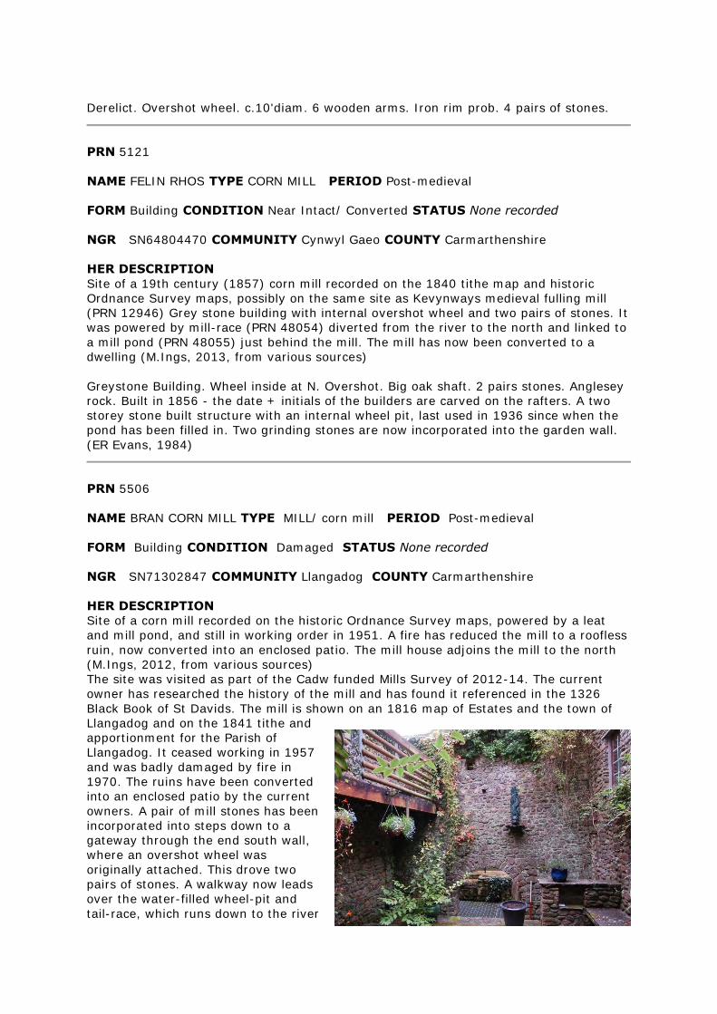
NAME BRAN CORN MILL TYPE MILL/ corn mill PERIOD Post-medieval
FORM Building CONDITION Damaged STATUS None recorded
NGR SN71302847 COMMUNITY Llangadog COUNTY Carmarthenshire
HER DESCRIPTION
Site of a corn mill recorded on the historic Ordnance Survey maps, powered by a leat
and mill pond, and still in working order in 1951. A fire has reduced the mill to a roofless
ruin, now converted into an enclosed patio. The mill house adjoins the mill to the north
(M.Ings, 2012, from various sources)
The site was visited as part of the Cadw funded Mills Survey of 2012-14. The current
owner has researched the history of the mill and has found it referenced in the 1326
Black Book of St Davids. The mill is shown on an 1816 map of Estates and the town of
Llangadog and on the 1841 tithe and
apportionment for the Parish of
Llangadog. It ceased working in 1957
and was badly damaged by fire in
1970. The ruins have been converted
into an enclosed patio by the current
owners. A pair of mill stones has been
incorporated into steps down to a
gateway through the end south wall,
where an overshot wheel was
originally attached. This drove two
pairs of stones. A walkway now leads
over the water-filled wheel-pit and
tail-race, which runs down to the river
to the west of the mill. The mill pond, located to the right of the property entrance
alongside the road, has been infilled by the current owners. The pond supplied water for
two leats; one to the wheel-pit, which is now grassed over as a lawn although an
overflow ramp survives, and the other to an undershot, iron wheel used to power an
electrical generator, located north of the main mill complex. This was installed in the
early 20th century and was still working in 1958 when it was bought and destroyed by
the Electrical Light Company. The foundations of the generator still survive (M.Ings,
2012)
Working mill; overshot wheel c10' diam, wooden buckets and arms; large oat shaft. Mill
machinery 2 pairs of stones. 2nd wheel outside all iron.
PRN 7825
NAME MELIN NANTYREGLWYS TYPE CORN MILL PERIOD Post-medieval
FORM Documents CONDITION Damaged STATUS None recorded
NGR SN2503322068 COMMUNITY Llanboidy COUNTY Carmarthenshire
HER DESCRIPTION
Site of a corn mill recorded on the 1889 1st edition and 1907 2nd edition Ordnance
Survey maps. An overshot wheel was powered by a mill-pond close to the farmhouse,
fed from a long mill-race diverted from the Afon Fenni to the northwest. The building, of
split slate rubble, was recorded in 1977 to be more or less ruinous, with its machinery
removed by Pembrokeshire Museum (M.Ings, 2013, from various sources)
PRN 8222
NAME MIDDLE MILL; FELIN GANOL TYPE Corn mill PERIOD Post-medieval
FORM Building CONDITION Near Intact; Converted STATUS None recorded
NGR SN41350720 COMMUNITY Kidwelly COUNTY Carmarthenshire
HER DESCRIPTION
Site of an early 19th century corn mill, of rubble masonry, recorded on the historic
Ordnance Survey maps within Kidwelly, with an internal undershot or breast-shot wheel
powered by a mill-race diverted at a weir from the Gwendraeth Fach to the east. Disused
around 1918 and machinery removed around 1945. The site is shown as ruinous on
modern mapping although a recent aerial photograph indicates it to be restored and/or
converted (M.Ings, 2013, from various sources)
The mill was visited to ascertain its current condition during the Cadw funded Mills
Survey of 2012-14. Unfortunately the owners were away but it was seen that the mill is
now converted for domestic use. The archway access where the tail-race emerges from
under the building is preserved and the name 'Felin Ganol' is painted above the
entranceway (M.Ings, 2013)

PRN 8412
NAME TOWN MILL TYPE MILL PERIOD Medieval/ Post-medieval
FORM Building CONDITION Near Intact/ Converted STATUS None recorded
NGR SN770340 COMMUNITY Llandovery COUNTY Carmarthenshire
HER DESCRIPTION
The 'Town Mill', just to the south of Llandovery in Carmarthenshire, is recorded on the
historic Ordnance Survey maps. The building appears restored and/or converted on
modern mapping and aerial photographs (M.Ings, 2013)
PRN 8497
NAME BISHOPS MILL TYPE LEAT PERIOD Medieval/ Post-medieval
FORM Earthwork CONDITION Restored STATUS None recorded
NGR SN4350721067 COMMUNITY Abergwili COUNTY Carmarthenshire
HER DESCRIPTION
Tail race recorded on the historic Ordnance Survey maps to the southwest of Abergwili
and crossing the fields to power Bishop's Mill (PRN 16457) Of possible medieval origin
(M.Ings, 2013)
Abergwili - medieval manor of Bishops of St Davids; mill of presumed medieval origin.
This leat has recently been dredged for use as a drain. The material has been dumped
on the North side of the tumulus in Abergwili PRN 1731. ER Evans 1983
PRN 9909
NAME FELIN RECKITT TYPE CORN MILL PERIOD Post-medieval
FORM Building CONDITION Near Intact/ Near Destroyed STATUS None recorded
NGR SN33602129 COMMUNITY Abernant COUNTY Carmarthenshire
HER DESCRIPTION
Felin Ricket is recorded as a corn mill on the 1889 1st edition and 1906 2nd edition
Ordnance Survey maps, powered by a long mill race (PRN 33304) diverted off the Nant
Cynnen to the northeast. Of possible 18th century date, it was three storeys high with an
adjoining corn-drying house. Now demolished (M.Ings, 2013, from various sources)
The site was visited as part of the Cadw funded Mills Project of 2012-14. Only a remnant
of the southwest-facing sidewall of the drying house and northwest-facing rear wall of
both drying house and mill survive to a height of some two metres and now capped with
concrete. The current owners told me that the buildings were taken down by the council
as they were deemed unsafe. The area of the mill footprint is now under hardcore for
car-parking. The wheel-pit is preserved at the northeastern end but the wheel itself has
gone. The mill-race (PRN 33304) was recorded in 1984 as having been infilled to make a
farm track (M.Ings, 2013)
3 storey stone built corn mill with drying house attached. Much of the machinery still
remaining. The wheel has been removed but a local man said that it was overshot and
situated on the E side. The leat has been filled in to make a farm track across the fields.
The East wall is in a dangerous state and needs some work (ER Evans,1984)
PRN 9954
NAME LLANLLWCH MILL TYPE CORN MILL PERIOD Post-medieval
FORM Building CONDITION Restored/ Converted STATUS None recorded
NGR SN38871888 COMMUNITY Carmarthen COUNTY Carmarthenshire
HER DESCRIPTION
Site of a corn mill recorded on the 1890 1st edition and 1906 2nd edition Ordnance
Survey maps, with associated mill-race (PRN 102941) and mill-pond (PRN 102940) The
mill has now been converted for domestic use (M.Ings, 2012)
The site was visited during the Cadw funded Mills Survey of 2012-14. The mill stands
three storeys high and adjoins the mill house. The associated mill-race (PRN 102941)
and mill-pond (PRN 102940) are preserved as earthworks (M.Ings, 2012)
The mill building has been renovated. The mill wheel has gone and a garage is now
positioned in its place. The wheel received its water supply from a mill race which started
250m to the SW at the millhead by the bridge at Mill Row cottages. From the wheel pit
the water was carried in a culvert under the road to the tail race. The tail race is still in a
good condition, approx 1m deep and 250m long. The mill pond has a well preserved
bank on its southern side approx 1.4m high. There is no longer any water in the pond.
(L.Weeks 23/07/85) Grist mill in town rental of 1633, 1667 (TAJ, 1980)
PRN 11635
NAME COTHY BRIDGE TYPE Corn Mill/ Water Mill PERIOD Medieval
EVIDENCE Documentary Evidence CONDITION Not known STATUS None recorded
NGR SN5021 COMMUNITY Llanegwad COUNTY Carmarthenshire
HER DESCRIPTION
Location for this medieval corn mill is now uncertain. Its name suggests a possible
connection with the post-medieval Cothi Mill (PRN 29734) and it may have stood on the
same site (M.Ings, 2012)
From the will of Bishop Richard Davies AD. 1581. TCASFC Called at Felin Mynachdy - no
answer. (L. Weeks, DAT 1985)
PRN 11656
NAME MARROS MILL TYPE Water Mill PERIOD Medieval/ Post Medieval
EVIDENCE Building/ Ruined Building CONDITION Near Destroyed STATUS None
recorded
NGR SN2070307565 COMMUNITY Eglwyscummin COUNTY Carmarthenshire
HER DESCRIPTION
The foundations of what is presumed to be Marros Mill have been observed eroding at
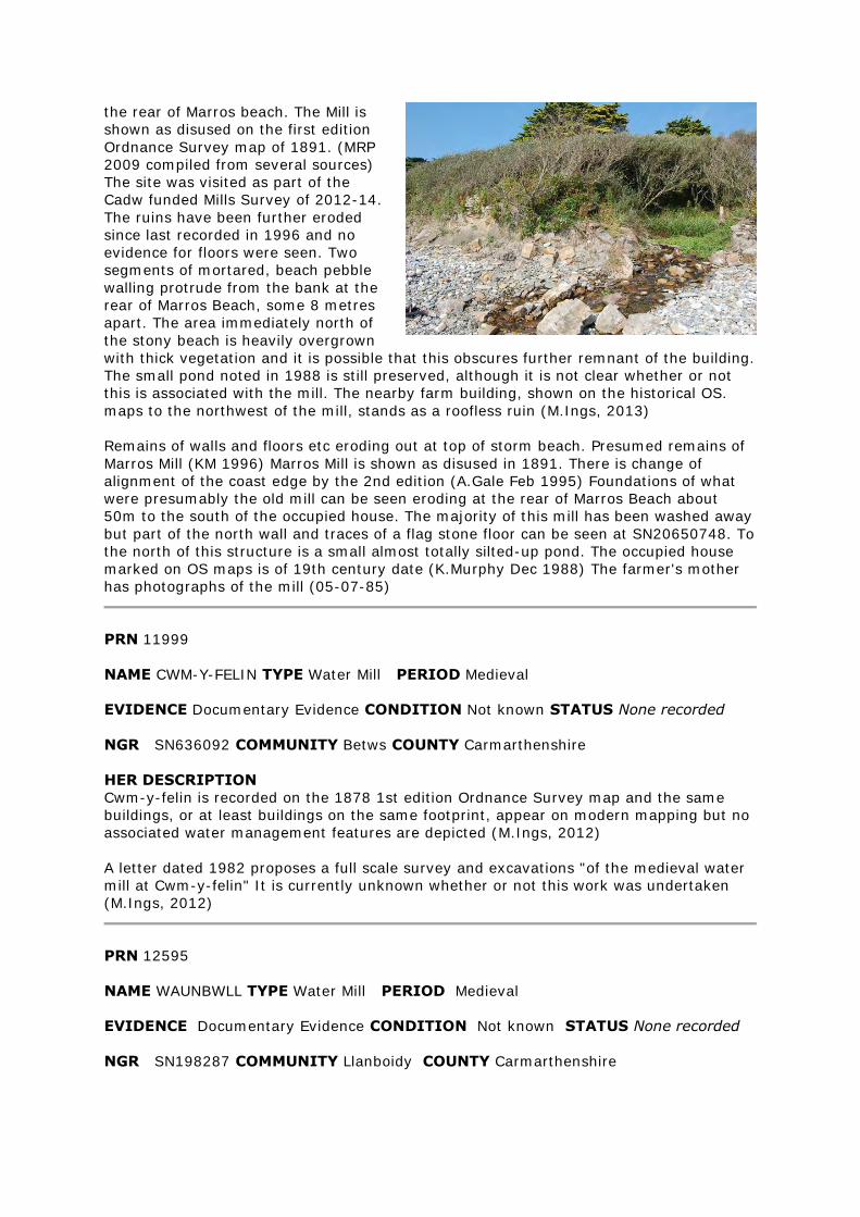
the rear of Marros beach. The Mill is
shown as disused on the first edition
Ordnance Survey map of 1891. (MRP
2009 compiled from several sources)
The site was visited as part of the
Cadw funded Mills Survey of 2012-14.
The ruins have been further eroded
since last recorded in 1996 and no
evidence for floors were seen. Two
segments of mortared, beach pebble
walling protrude from the bank at the
rear of Marros Beach, some 8 metres
apart. The area immediately north of
the stony beach is heavily overgrown
with thick vegetation and it is possible that this obscures further remnant of the building.
The small pond noted in 1988 is still preserved, although it is not clear whether or not
this is associated with the mill. The nearby farm building, shown on the historical OS.
maps to the northwest of the mill, stands as a roofless ruin (M.Ings, 2013)
Remains of walls and floors etc eroding out at top of storm beach. Presumed remains of
Marros Mill (KM 1996) Marros Mill is shown as disused in 1891. There is change of
alignment of the coast edge by the 2nd edition (A.Gale Feb 1995) Foundations of what
were presumably the old mill can be seen eroding at the rear of Marros Beach about
50m to the south of the occupied house. The majority of this mill has been washed away
but part of the north wall and traces of a flag stone floor can be seen at SN20650748. To
the north of this structure is a small almost totally silted-up pond. The occupied house
marked on OS maps is of 19th century date (K.Murphy Dec 1988) The farmer's mother
has photographs of the mill (05-07-85)
PRN 11999
NAME CWM-Y-FELIN TYPE Water Mill PERIOD Medieval
EVIDENCE Documentary Evidence CONDITION Not known STATUS None recorded
NGR SN636092 COMMUNITY Betws COUNTY Carmarthenshire
HER DESCRIPTION
Cwm-y-felin is recorded on the 1878 1st edition Ordnance Survey map and the same
buildings, or at least buildings on the same footprint, appear on modern mapping but no
associated water management features are depicted (M.Ings, 2012)
A letter dated 1982 proposes a full scale survey and excavations "of the medieval water
mill at Cwm-y-felin" It is currently unknown whether or not this work was undertaken
(M.Ings, 2012)
PRN 12595
NAME WAUNBWLL TYPE Water Mill PERIOD Medieval
EVIDENCE Documentary Evidence CONDITION Not known STATUS None recorded
NGR SN198287 COMMUNITY Llanboidy COUNTY Carmarthenshire
HER DESCRIPTION
Site of a mill recorded by Rees (1932) on his map of Wales in the 14th century. Its
location is now uncertain. Possibly it refers to 'Old Mill', recorded on the 1st edition
Ordnance Survey map and modern mapping, just to the north of Waun-bwll farmstead
(M.Ings, 2012)
PRN 12610
NAME CWMFFRWD TYPE FULLING MILL PERIOD Medieval
FORM Documents CONDITION Not Known STATUS None recorded
NGR SN165459 COMMUNITY St Dogmaels COUNTY Pembrokeshire
HER DESCRIPTION
Early sources indicate that there was a fulling mill established in St Dogmaels by the
14th century. Its location is unknown but it may have been to the south eastern corner
of the parish towards the neighbouring Cwmffrwd valley.
Place-names near site 'Mill House', 'Velindre House', 'Mill street'.
PRN 12627
NAME BANC-Y-FELIN TYPE WATER MILL/ corn mill PERIOD Medieval/ Post-Medieval
FORM Documents CONDITION Damaged STATUS None recorded
NGR SN298364 COMMUNITY Cenarth COUNTY Carmarthenshire
HER DESCRIPTION
A corn mill shown on the historic Ordnance Survey maps, possibly located on the same
site as a watermill recorded on Rees's 14th century map of South Wales. It is powered
by a mill-race (PRN 30682) diverted from the Afon Mamog (M.Ings, 2012)
The site was visited (twice) during the Cadw funded Mills project of 2012-14.
Unfortunately the owners were away both times so it was not possible to get a good
view of the site. A ruinous dry-stone building was noted behind the house, largely
obscured by vegetation but just how much survives and whether it represents remains of
the corn mill are unclear. The mill-race (PRN 30682) is preserved as a distinctive
earthwork where it crosses the pasture field to the east of the mill. (M.Ings, 2012)
PRN 12644
NAME MUNDEGY MILL; MONDEGY;MONDEGUY TYPE WATER MILL/ corn mill
PERIOD Medieval/ Post-Medieval
FORM Documents CONDITION Not known STATUS None recorded
NGR SN330126 COMMUNITY Llansteffan COUNTY Carmarthenshire
HER DESCRIPTION
Mill recorded on Rees's map (1932) of South Wales & Border in the 14th century but the
location is now uncertain. Likely to be on the site of Felin Pen-degy, a corn mill recorded
on the historical Ordnance Survey maps as part of a farmstead complex. Modern
mapping and aerial photograph show these buildings still in use (M.Ings, 2012, from
various sources)
PRN 12699
NAME FELIN FFOREST TYPE WATER MILL PERIOD Medieval
FORM Documents CONDITION STATUS None recorded
NGR SN578044 COMMUNITY Llanedi COUNTY Carmarthenshire
HER DESCRIPTION
Site of a water-powered mill recorded by Rees (1932) on his map of South Wales and
Border in the 14th century. Although the exact location of this mill is uncertain, it
possibly stood on the same site as later corn mill PRN 4712, which dates from at least
the 17th century (M.Ings, 2012)
PRN 12720
NAME LLANFYNYDD TYPE WATER MILL PERIOD Medieval
FORM Documents CONDITION STATUS None recorded
NGR SN5526 COMMUNITY Llanfynydd COUNTY Carmarthenshire
HER DESCRIPTION
There is a record of a medieval water-powered mill at Llanfynydd (Rees, 1932), which
may be at the same location as the post-medieval Bishop's Mill (PRN 22528).
PRN 12728
NAME GRONDREF; FELIN-FACH TYPE WATER MILL PERIOD Medieval
FORM Complex CONDITION Not Known/ Near Destroyed STATUS None recorded
NGR SN561377 COMMUNITY Llanybydder COUNTY Carmarthenshire
HER DESCRIPTION
Felin Fach is recorded on the 1887 1st edition Ordnance Survey map, located just to the
northeast of a wood bearing the same name and on the west bank of the Afon Gorlech.
It is not depicted on the 2nd edition O.S. or subsequent mapping. The area is now
owned by the Forestry Commission (M.Ings, 2012)
The site was visited during the Cadw funded mills Survey of 2012-14 to see what, if
anything, survived of the site. The recorded location is now under thick undergrowth
above the river and no structural remains were evident. There is a relatively level area
and several large stones were apparent just below the surface, but it was unclear
whether these features are archaeological or natural (M.Ings, 2012)
The name Grondref is given to a spot to the north-east of the water-powered mill as
marked on the Rees map and so is probably not related to the mill at all. The dwelling at
Grondre is PRN 30197. The mill is probably better connected with PRN 17147 given to
the place-name element Felin Fach (JH, June 1995). Ddau Uchaf, Rhydcymerau. A local
man said that the site is owned by the forestry commission and doesn't know anything
of there being a water mill in existence.
PRN 12731
NAME CRAG-Y-CAER MILL TYPE WATER MILL PERIOD Medieval
FORM Documents CONDITION Not known STATUS None recorded
NGR SN652190 COMMUNITY Dyffryn Cennen COUNTY Carmarthenshire
HER DESCRIPTION
Mill shown on Rees's map (1932) of South Wales & Border in the 14th century. The
location is now uncertain. It was possibly on the same site as the later, post-medieval
Carreg Cennen Mill (PRN 25725), recorded on the historic Ordnance Survey maps
(M.Ings, 2012)
PRN 12739
NAME TREGIB MILL TYPE Water Mill PERIOD Medieval
EVIDENCE Documentary Evidence CONDITION Near Destroyed STATUS None
recorded
NGR SN632215 COMMUNITY Manordeilo and Salem COUNTY Carmarthenshire
HER DESCRIPTION
Medieval mill shown on Rees's map (1932) of South Wales & Border in the 14th century.
Its location is now uncertain but it possibly occupied the same site as post-medieval
Tregeyb Mill (PRN 22438) (M.Ings, 2012)
PRN 12740
NAME CARREG SAWDDE TYPE WATER MILL PERIOD Medieval
FORM Documents CONDITION STATUS None recorded
NGR SN699277 COMMUNITY Llangadog COUNTY Carmarthenshire
HER DESCRIPTION
Record of a water-powered mill on Rees's (1932) map of South Wales and Border in the
14th century. Its location is uncertain but it is likely to have stood on the same site as
post-medieval Cwm Sawdde Mill (PRN 4882), powered by an extensive mill-race (PRN
102949) (M.Ings, 2012)
PRN 12748
NAME LLANSAWEL TYPE WATER MILL PERIOD Medieval
FORM Documents CONDITION STATUS None recorded
NGR SN619361 COMMUNITY Llansawel COUNTY Carmarthenshire
HER DESCRIPTION
Record of a water-powered mill on Rees's map (1932) of South Wales & Border in the
14th century. Location uncertain but possibly the same site as post-medieval corn mill
PRN 4897 (M.Ings, 2013)
PRN 12749
NAME FELIN BRAN; FELIN FRAN TYPE WATER MILL/ corn mill PERIOD Medieval
FORM Documents CONDITION Converted STATUS NPBB
NGR SN7750029800 COMMUNITY Myddfai COUNTY Carmarthenshire
HER DESCRIPTION
Felin Bran is a water-powered corn mill recorded on the 1886 1st edition and 1906 2nd
edition Ordnance Survey maps, with an associated mill race diverted from the Afon Bran,
a mill pond (PRN 102942) and tailrace. The mill was originally one of two grist mills in
the manor of Myddfai established by the 14th century. Modern mapping names the mill
Felin Fran and it has now been converted to domestic use (M.Ings, 2012, from various
sources)
The site was visited during the Cadw funded Mill Survey of 2012-14. The conversion of
the mill building for domestic use was underway, with the main structure being retained.
A gable-ended extension that was on the northwestern end of the mill, shown on the
historic maps, has been removed leaving an outline where it originally adjoined the main
building. A new extension is being added to the southeastern end of the building. The
extensive mill pond, to the northeast of the mill, is now infilled and vegetated but the
steep surrounding bank is still intact and the point where the leat entered, at the eastern
end, is still evident. The tailrace is now below the parking area in front of the mill
building. The line of the leat runs more or less parallel to the Afon Bran, through pasture
fields belonging to a neighbouring farm. The owners were away so the leat could not be
traced but it was not visibly evident from the roadside (M.Ings, 2012)
PRN 12750
NAME LLANGADOG TYPE WATER MILL PERIOD Medieval
FORM Documents CONDITION Near Destroyed STATUS None recorded
NGR SN713285 COMMUNITY Llangadog COUNTY Carmarthenshire
HER DESCRIPTION
Mill shown on Rees's map (1932) of South Wales & Border in the 14th century. Its
location is now uncertain but it is likely to have been on the same site as post-medieval
Bran corn mill (PRN 5506) (M.Ings, 2012)
Bran Mill (PRN 5506) was visited during the Cadw funded Mills Survey of 2012-14. The
current owner has found a reference to the mill in the 1326 Black Book of St Davids,
indicating that the site has medieval origins and is likely to be the mill recorded by Rees
(M.Ings, 2012)
PRN 12752
NAME CROWN MILL TYPE WATER MILL PERIOD Medieval
FORM Documents CONDITION Converted STATUS None recorded
NGR SN7834 COMMUNITY Llandovery COUNTY Carmarthenshire
HER DESCRIPTION
Site of a corn mill recorded on the historic Ordnance Survey maps, powered by a mill-
race diverted at a weir from the Afon Gwydderig to the east. The building appears
restored and/or converted on modern mapping and aerial photography and the water-
management features are not recorded on the modern map (M.Ings, 2013)
PRN 12931
NAME CARNWYLLION;CAMOYLE;COED-CYW;MORLAIS MILL TYPE FULLING MILL/ flour
mill PERIOD Medieval/ Post-Medieval
FORM Documents CONDITION Converted STATUS None recorded
NGR SN532074 COMMUNITY Llannon COUNTY Carmarthenshire
HER DESCRIPTION
Site of a flour mill recorded on the 1878 1st edition Ordnance Survey map and shown as
disused on the 1906 2nd ed. OS. Possibly on the same site as a water-powered mill
recorded on Rees’ (1932) map of Wales and the Marches in the 14th century. On modern
mapping the building is shown as a component of the Coed-cyw farmstead (M.Ings,
2013)
Rees indicates water mill on or near this site.
PRN 12932
NAME CARNWYLLION;TROSERCH TYPE FULLING MILL PERIOD Medieval
FORM Documents CONDITION Near Destroyed STATUS None recorded
NGR SN554033 COMMUNITY Llangennech COUNTY Carmarthenshire
HER DESCRIPTION
Documented site of a fulling mill on the site of a later corn mill (PRN 16750). A field
placename, Cae'r Pandy, indicates the location of a fulling mill and R.I.Jack (1981) notes
that a lease was granted for a private pandy (fulling mill), 'probably at the existing
Troserch Mill', in 1441, which disappeared after 1459. The post-medieval mill on the site
is now in ruins (M.Ings, 2012, from various sources)
PRN 12936
NAME GLYNCOTHI TYPE FULLING MILL PERIOD Medieval
FORM Documents CONDITION Not known STATUS None recorded
NGR SN537311 COMMUNITY Llanfihangel Rhos-y-Corn COUNTY Carmarthenshire
HER DESCRIPTION
Site of a possible medieval fulling mill of uncertain location. Possibly it stood at the same
location as post-medieval corn mill Felin FForest (PRN 17103) (M.Ings, 2013)
PRN 12939
NAME GLANGWENDRAETH TYPE FULLING MILL PERIOD Medieval
FORM Documents CONDITION STATUS None recorded
NGR SN414072 COMMUNITY Kidwelly COUNTY Carmarthenshire
HER DESCRIPTION
Site of a medieval fulling mill recorded on Rees's map (1932) of Wales and Border in the
14th century. Location uncertain and not shown on historic Ordnance Survey maps or
modern mapping (M.Ings, 2013)
1435 New fulling mill on the Gwendraeth Fach between the grain mill called Cadog's Mill
and Middle Mill. (Arch Camb.)
PRN 12944
NAME LE HAMME TYPE Fulling Mill PERIOD Medieval
EVIDENCE Documentary Evidence CONDITION Near Destroyed STATUS None
recorded
NGR SN417074 COMMUNITY Kidwelly COUNTY Carmarthenshire
HER DESCRIPTION
Site of a medieval mill, the location of which is now uncertain. It possibly stood on the
same site as post-medieval Upper Mill (PRN 102948), recorded on the historic Ordnance
Survey maps (M.Ings, 2012, from various sources)
In 1443 a second new fulling mill was constructed on the Gwendraeth Fach at Le Hamme
above the most easterly of the grain mills Cadog's Mill. (Arch Camb.)
PRN 12950
NAME FELINFOEL MILL TYPE FULLING MILL PERIOD Medieval
FORM Documents CONDITION Near Destroyed STATUS None recorded
NGR SN518023 COMMUNITY Llanelli Rural COUNTY Carmarthenshire
HER DESCRIPTION
Felinfoel flour mill is recorded on the historic Ordnance Survey maps, powered by a long
mill-race (PRN 105485), diverted from the Afon Lliedi to the north, feeding into a holding
pond just behind the mill building. The mill and its associated water-management are
not shown on modern mapping and the site is recorded (RCAHMW) to be destroyed
(M.Ings, 2013, from various sources)
The site was visited during the Cadw funded Mills Survey of 2012-14 to ascertain
whether any of the complex has been preserved. The location of the mill building is now
marked by a sculptural representation of a waterwheel and the surroundings have been
landscaped as a public green space. Below ground archaeological deposits potentially
survive. It was unclear whether the earthwork banks in the vicinity represent preserved
remnant of the mill-pond or are of recent date. An information panel at the site says that
the mill was demolished in 1973, following the construction of the Cwm Lliedi reservoir
that diminished the flow of the Afon Lliedi. It is thought that a corn mill has existed in
Felinfoel since 1399 (M.Ings, 2013)
PRN 12954
NAME PANDY;MAENOR FORION TYPE Fulling Mill PERIOD Medieval
EVIDENCE Documentary Evidence CONDITION Near Destroyed STATUS None
recorded
NGR SN390389 COMMUNITY Llangeler COUNTY Carmarthenshire
HER DESCRIPTION
Site of a possible medieval fulling mill, the location of which is now uncertain. Possibly it
stood on the same site as the post-medieval fulling mill, Yr Hadod (PRN 15855) (M.Ings,
2012)
No information to be found of a medieval fulling mill, although there are several post-
medieval mills in the same area (AS Maull, 1984)
PRN 12980
NAME MELIN WAUN TYPE CORN MILL/ FULLING MILL PERIOD Medieval
FORM Documents CONDITION Near Destroyed STATUS None recorded
NGR SN6340034400 COMMUNITY Talley COUNTY Carmarthenshire
HER DESCRIPTION
Site of a corn mill recorded on the 1st and 2nd edition Ordnance Survey maps. Not
shown on modern mapping (M.Ings, 2012)
The site was visited during the Cadw funded Mills Survey of 2012-14. The current owner
said that the mill building was demolished in the 1980s, with the roof slates, windows,
doors and timbers apparently removed to Bath and many of the stones, including the
quoins, utilised by a neighbour. The remainder was left as a demolition mound on the
site until clearance work started to make room for a polytunnel and timber barn. During
this work a length of the leat was uncovered, with an intact stone arch and the remains
of an iron and wooden wheel. This has now been infilled with rubble from the mill. Under
the footprint of the polytunnel, where the mill originally stood, a crescent of cobbles was
found. These were protected before being covered again. The remains of a mill stone
have been placed within the owner's garden. The remnant of the gully that fed the leat is
evident within the wooded slopes above the mill to the east (M.Ings, 2012)
In 1537-8 Talley Abbey leased a 'fulling mill and grist mill' at Trallwng Elgan (or
Traethnelgan) Grange. For the grange see PRN 12966. One or both of these mills
possibly occupied the same site as Edwinsford Mill (PRN 5107).
PRN 15095
NAME FELIN ISAF TYPE CORN MILL PERIOD Post-medieval
FORM Building CONDITION Not Known/ Intact STATUS None recorded
NGR SN22092207 COMMUNITY Llanboidy COUNTY Carmarthenshire
HER DESCRIPTION
Site of corn mill recorded on the 1889 1st edition and 1907 2nd edition Ordnance Survey
maps, powered by a long mill-race diverted from the Afon Gronw to the north. The
building is still shown on modern mapping, possibly restored and/or converted and the
race is preserved as a drain (M.Ings, 2013)
PRN 15301
NAME CLYN FELIN TYPE MILL/ cottage PERIOD Post-medieval
FORM Documents CONDITION Not Known STATUS None recorded
NGR SN2789730482 COMMUNITY Trelech COUNTY Carmarthenshire
HER DESCRIPTION
Clyn-felin is recorded on the historic Ordnance Survey maps and its name suggests a
mill site. However, no associated features denote this to be a mill and it may be a
cottage named for its proximity to Dan-y-graig woollen mill to the southwest. Shown to
be ruinous on modern mapping (M.Ings, 2013)
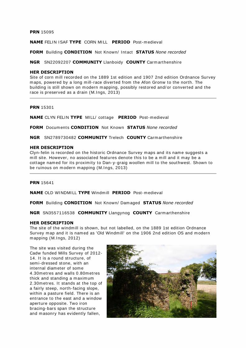
PRN 15641
NAME OLD WINDMILL TYPE Windmill PERIOD Post-medieval
FORM Building CONDITION Not Known/ Damaged STATUS None recorded
NGR SN3557116538 COMMUNITY Llangynog COUNTY Carmarthenshire
HER DESCRIPTION
The site of the windmill is shown, but not labelled, on the 1889 1st edition Ordnance
Survey map and it is named as 'Old Windmill' on the 1906 2nd edition OS and modern
mapping (M.Ings, 2012)
The site was visited during the
Cadw funded Mills Survey of 2012-
14. It is a round structure, of
semi-dressed stone, with an
internal diameter of some
4.30metres and walls 0.80metres
thick and standing a maximum
2.30metres. It stands at the top of
a fairly steep, north-facing slope,
within a pasture field. There is an
entrance to the east and a window
aperture opposite. Two iron
bracing-bars span the structure
and masonry has evidently fallen,
particularly from the internal, southeastern wall (M.Ings, 2012)
"On the roadside leading from Llangynnock to Carmarthen will be found the ruins of a
windmill. No one now living remembers it at work; it is said, however, to have been in
use about 90 years ago. The then miller was a noted character...." TCASFC 1909-10
vol.5, p.74
PRN 15794
NAME FELIN FACH TYPE CORN MILL PERIOD Post-medieval
FORM Building CONDITION Not Known/ Near Destroyed STATUS None recorded
NGR SN32572912 COMMUNITY Cynwyl Elfed COUNTY Carmarthenshire
HER DESCRIPTION
The corn mill is recorded on the historic Ordnance Survey maps beside the Afon Cywyn,
part of a small community named Felin-fach, that also included several cottages and a
smithy (PRN 15792). The mill is powered by a mill-race diverted from, and running
parallel to, the river. Modern mapping shows all the buildings of this settlement to now
be ruinous (M.Ings, 2012)
The site was visited during the Cadw funded Mills Survey of 2012-14. All the settlement
buildings are now ruinous and heavily overgrown. The location of the mill was judged
from the historic Ordnance Survey maps. It is on a level platform built into a steep bank.
The indistinct remnant of the walls forming a rectilinear building, measuring
approximately 10 x 6 metres and aligned southeast-northwest, can be made out
although they are now almost down to foundation level and obscured by undergrowth,
several trees and tumbled masonry. No internal features could be discerned, although
there is a possible entrance in the northwest corner. The probable line of the mill-race
was evident as a levelled area cutting into the contour of the slope to the north of the
mill.
A second building, approximately 5 metres square, was noted, located just to the
southeast of the mill. The east and south wall stand a maximum 1.63 metres high, the
north and west walls almost down to foundation level. It is uncertain whether this is
associated with the mill and there was nothing to identify its function (M.Ings, 2012)
PRN 15800
NAME FELIN PEN-Y-BONT TYPE MILL/ corn mill PERIOD Post-medieval
FORM Building CONDITION Not Known/ Damaged STATUS None recorded
NGR SN3061227387 COMMUNITY Trelech COUNTY Carmarthenshire
HER DESCRIPTION
Site of a corn mill located beside the Dewi Fawr, just to the north of Pen-y-bont.
Recorded on the historical Ordnance Survey maps but shown on modern mapping to now
be ruinous (M.Ings, 2012)
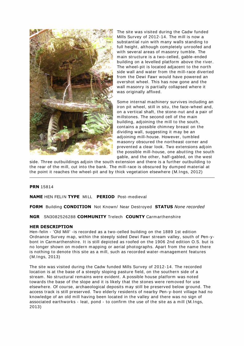
The site was visited during the Cadw funded
Mills Survey of 2012-14. The mill is now a
substantial ruin with many walls standing to
full height, although completely unroofed and
with several areas of masonry tumble. The
main structure is a two-celled, gable-ended
building on a levelled platform above the river.
The wheel-pit is located adjacent to the north
side wall and water from the mill-race diverted
from the Dewi Fawr would have powered an
overshot wheel. This has now gone and the
wall masonry is partially collapsed where it
was originally affixed.
Some internal machinery survives including an
iron pit wheel, still in situ, the face-wheel and,
on a vertical shaft, the stone-nut and a pair of
millstones. The second cell of the main
building, adjoining the mill to the south,
contains a possible chimney breast on the
dividing wall, suggesting it may be an
adjoining mill-house. However, tumbled
masonry obscured the northeast corner and
prevented a clear look. Two extensions adjoin
the possible mill-house, one abutting the south
gable, and the other, half-gabled, on the west
side. Three outbuildings adjoin the south extension and there is a further outbuilding to
the rear of the mill, cut into the bank. The mill-race is obscured by dumped material at
the point it reaches the wheel-pit and by thick vegetation elsewhere (M.Ings, 2012)
PRN 15814
NAME HEN FELIN TYPE MILL PERIOD Post-medieval
FORM Building CONDITION Not Known/ Near Destroyed STATUS None recorded
NGR SN3082526288 COMMUNITY Trelech COUNTY Carmarthenshire
HER DESCRIPTION
Hen-felin - 'Old Mill' -is recorded as a two-celled building on the 1889 1st edition
Ordnance Survey map, within the steeply sided Dewi Fawr stream valley, south of Pen-y-
bont in Carmarthenshire. It is still depicted as roofed on the 1906 2nd edition O.S. but is
no longer shown on modern mapping or aerial photographs. Apart from the name there
is nothing to denote this site as a mill, such as recorded water-management features
(M.Ings, 2013)
The site was visited during the Cadw funded Mills Survey of 2012-14. The recorded
location is at the base of a steeply sloping pasture field, on the southern side of a
stream. No structural remains were evident. A possible house platform was noted
towards the base of the slope and it is likely that the stones were removed for use
elsewhere. Of course, archaeological deposits may still be preserved below ground. The
access track is still preserved. Two elderly residents of nearby Pen-y-bont village had no
knowledge of an old mill having been located in the valley and there was no sign of
associated earthworks - leat, pond - to confirm the use of the site as a mill (M.Ings,
2013)
PRN 15824
NAME CWM FELIN TYPE MILL PERIOD Post-medieval
FORM Documents CONDITION Not Known/ Near Destroyed STATUS None
recorded
NGR SN31122515 COMMUNITY Trelech COUNTY Carmarthenshire
HER DESCRIPTION
Cwm-felin is recorded on the historic Ordnance Survey maps, located on the steep slope
of a stream valley. The name indicates a mill site but no system of water-management is
evident from the mapping. The mill is no longer shown on the modern map and a recent
(Ordnance Survey, 2009, Next Perspectives) aerial photograph shows the area to be
under scrub and trees (M.Ings, 2013)
PRN 15855
NAME YR HADOD TYPE Mill/ Fulling Mill PERIOD Post Medieval/ Post-Medieval
EVIDENCE Building CONDITION Not Known/ Intact STATUS None recorded
NGR SN38943875 COMMUNITY Llangeler COUNTY Carmarthenshire
HER DESCRIPTION
Site of a fulling mill recorded on the historic Ordnance Survey maps, possibly associated
with an earlier, medieval fulling mill (PRN 12954) recorded in the vicinity, the location of
which is now uncertain. A building on the same footprint is still shown on modern maps,
although not labelled as a mill (M.Ings, 2014)
The site was visited as part of the Cadw funded Mills Survey of 2012-14. The building
that stands on the same footprint as the mill shown on the historic maps is now a private
house. There were no evident features to suggest that this was once a mill and it is
uncertain whether the current building has been converted from the mill or is a new-
build. Unfortunately the owners were away at the time of the visit. The mill was powered
by a mill race diverted from the Afon Siedi, to the east. It was possible to see a break in
the bank of the river where the mill race once left it, together with possible remnants of
a weir used to help divert water into the channel, but the mill race has now been infilled.
The possible line of the tail-race, to the northwest of the mill, appears preserved as a
grassed-over earthwork alongside the road (M.Ings, 2014).
PRN 16443
NAME FELIN FACH TYPE MILL PERIOD Post-medieval
FORM Building CONDITION Not Known/ Near Destroyed STATUS None recorded
NGR SN4440623329 COMMUNITY Abergwili COUNTY Carmarthenshire
HER DESCRIPTION
Felin-fach is recorded on the 1889 1st edition and 1906 2nd edition Ordnance Survey
maps, powered by a mill-race diverted from the Nant Crychiau. The site is not shown on
modern mapping (M.Ings, 2012)
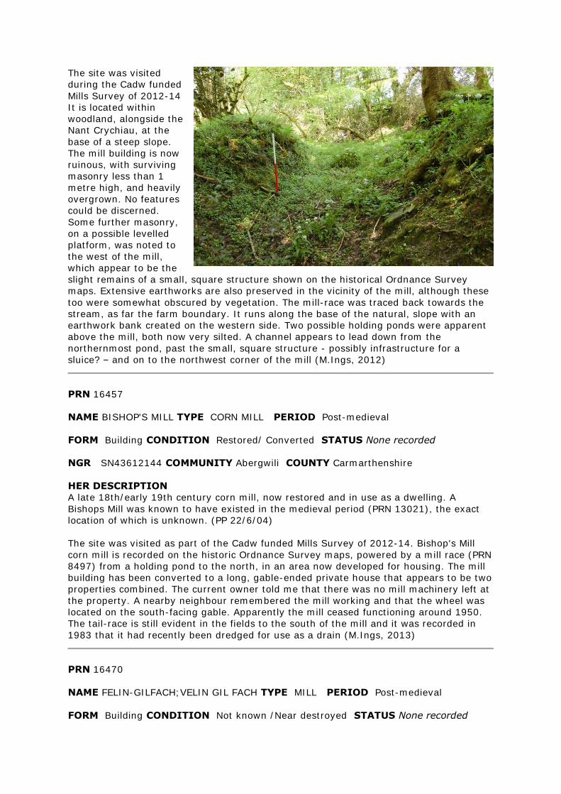
The site was visited
during the Cadw funded
Mills Survey of 2012-14
It is located within
woodland, alongside the
Nant Crychiau, at the
base of a steep slope.
The mill building is now
ruinous, with surviving
masonry less than 1
metre high, and heavily
overgrown. No features
could be discerned.
Some further masonry,
on a possible levelled
platform, was noted to
the west of the mill,
which appear to be the
slight remains of a small, square structure shown on the historical Ordnance Survey
maps. Extensive earthworks are also preserved in the vicinity of the mill, although these
too were somewhat obscured by vegetation. The mill-race was traced back towards the
stream, as far the farm boundary. It runs along the base of the natural, slope with an
earthwork bank created on the western side. Two possible holding ponds were apparent
above the mill, both now very silted. A channel appears to lead down from the
northernmost pond, past the small, square structure - possibly infrastructure for a
sluice? – and on to the northwest corner of the mill (M.Ings, 2012)
PRN 16457
NAME BISHOP'S MILL TYPE CORN MILL PERIOD Post-medieval
FORM Building CONDITION Restored/ Converted STATUS None recorded
NGR SN43612144 COMMUNITY Abergwili COUNTY Carmarthenshire
HER DESCRIPTION
A late 18th/early 19th century corn mill, now restored and in use as a dwelling. A
Bishops Mill was known to have existed in the medieval period (PRN 13021), the exact
location of which is unknown. (PP 22/6/04)
The site was visited as part of the Cadw funded Mills Survey of 2012-14. Bishop's Mill
corn mill is recorded on the historic Ordnance Survey maps, powered by a mill race (PRN
8497) from a holding pond to the north, in an area now developed for housing. The mill
building has been converted to a long, gable-ended private house that appears to be two
properties combined. The current owner told me that there was no mill machinery left at
the property. A nearby neighbour remembered the mill working and that the wheel was
located on the south-facing gable. Apparently the mill ceased functioning around 1950.
The tail-race is still evident in the fields to the south of the mill and it was recorded in
1983 that it had recently been dredged for use as a drain (M.Ings, 2013)
PRN 16470
NAME FELIN-GILFACH;VELIN GIL FACH TYPE MILL PERIOD Post-medieval
FORM Building CONDITION Not known /Near destroyed STATUS None recorded
NGR SN48232280 COMMUNITY Abergwili COUNTY Carmarthenshire
HER DESCRIPTION
Felin-gilfach is recorded on the 1889 1st edition and 1906 2nd edition Ordnance Survey
maps, located by a ford on the Afon Annell. The 1906 map indicates the mill to be
unroofed and the site is no longer shown on modern mapping (M.Ings, 2012)
The site was visited during the Cadw funded Mills Survey of 2012-14. No structural
remains were evident. There is a fenced-off area of scrub on the north bank of the river
and it is possible that archaeological deposits survive below ground (M.Ings, 2012)
PRN 16497
NAME OLD MILL TYPE MILL/ COTTAGE PERIOD Post-medieval
FORM Building CONDITION Not Known/ Damaged STATUS None recorded
NGR SN45182878 COMMUNITY Llanllawddog COUNTY Carmarthenshire
HER DESCRIPTION
Cottage ruins recorded as 'Old Mill' on the 1889 1st edition and 1906 2nd edition
Ordnance Survey maps. Located by side of mill-race running east-west from stream to
east of Nantcwmgwili farmstead to Pontarsais village. (M.Ings, 2012)
The site was visited during the Cadw funded Mills Survey of 2012-14. Evidently the
building shown on the historical Ordnance Survey maps was a cottage rather than a mill.
It is now a roofless ruinous on a levelled platform within a pasture field. It is of stone
rubble and partially rendered with concrete. The external walls stand a maximum 1.90
metres, with two windows and an entrance-way to the front. The groundfloor plan
comprises two rooms and the dividing gable survives to almost full height. There is a
central chimney with a fireplace on both sides of this gable, with pitched red-brick lintels.
The cottage is linked to the mill, which was located further west in the village of
Pontarsais by the mill-race. This has been infilled and its course is now a footpath. A
extensive section of wall from the mill survives within the front garden of a private
house, Maes y Felin (M.Ings, 2012)
PRN 16531
NAME FELIN GROES TYPE MILL PERIOD Post-medieval
FORM Building CONDITION Not Known/ Damaged STATUS None recorded
NGR SN44003122 COMMUNITY Llanfihangel-ar-Arth COUNTY Carmarthenshire
HER DESCRIPTION
Site of a corn mill recorded on the historic Ordnance Survey maps, to the southwest of
Alltwalis. A complex of three buildings is depicted, together with a water-management
system comprising a mill-race, mill-pond and sluice. Just one ruinous building is shown
on modern mapping, now in an area of woodland (M.Ings, 2012)
The site was visited during the Cadw funded Mills Survey of 2012-13. The surviving ruin
appears to be the northernmost recorded on the historic maps, a rectangular structure
aligned east-west. It stands in an area of woodland and thick vegetation. It was unclear
whether this was the mill building as there were no evident features to identify it as
such. It is gable-ended and built of semi-dressed blocks, the west gable and northeast
corner standing almost to full height. Elsewhere the walls are reduced to approximately
1 metre height and tumbled stones and slates were noted lying in the interior. There is a
doorway and window in the north-facing side wall and a second window in the west
gable. A boundary bank runs east-west, close to the rear of the building. A search was
made for structural remains of the other buildings but nothing could be seen in the thick
undergrowth. There was also no evidence for the line of the mill-race where it is depicted
running just to the east of the building or of the tail-race. The mill-race is preserved,
heavily silted, to the northeast, where it runs along the field boundary, and the area of
the mill-pond, although ill-defined, is very boggy. The sluice was not found. A visit to the
site when the vegetation has died down may be helpful (M.Ings, 2012)
PRN 16543
NAME FELIN-LLANPUMSAINT TYPE MILL/ corn mill PERIOD Post-medieval
FORM Building CONDITION Not Known/ Converted STATUS None recorded
NGR SN42232966 COMMUNITY Llanpumsaint COUNTY Carmarthenshire
HER DESCRIPTION
Felin-Llanpumsaint corn mill is recorded on the 1889 1st edition and 1906 2nd edition
Ordnance Survey maps, powered by a mill-race diverted from the Nant Alltwais to the
north, with an extensive holding pond just to the northeast of the mill building. These
features are still shown on modern mapping (M.Ings, 2013)
The site was visited as part of the Cadw funded Mills Survey of 2012-14. The mill is now
converted to a private house, with an ornamental, reproduction waterwheel attached to
the southeast gable. The owner said that there was no mill machinery preserved within
the house but that a pair of mill-stones were now located at the farm next door - these
have been set on edge either side of the gateway. The mill-pond and the mill-race are
also preserved, the latter at least partially, but could not be seen as they are located on
the farm's land and the owners were away (M.Ings, 2013)
PRN 16626
NAME FELIN GWM TYPE MILL PERIOD Post-medieval
FORM Building CONDITION Not Known/ Damaged STATUS None recorded
NGR SN4823936917 COMMUNITY Llanfihangel-ar-Arth COUNTY Carmarthenshire
HER DESCRIPTION
Felin Gwm is recorded on the 1888 1st edition and 1905 2nd edition Ordnance Survey
maps, located next to the Afon Gilwydeth within the woodland of Allt Perth-y-berllan.
The site is not shown on modern mapping (M.Ings, 2012)
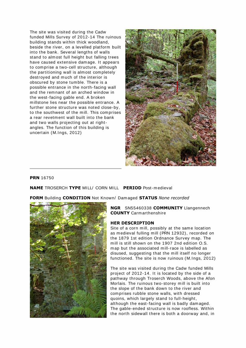
The site was visited during the Cadw
funded Mills Survey of 2012-14 The ruinous
building stands within thick woodland,
beside the river, on a levelled platform built
into the bank. Several lengths of walls
stand to almost full height but falling trees
have caused extensive damage. It appears
to comprise a two-cell structure, although
the partitioning wall is almost completely
destroyed and much of the interior is
obscured by stone tumble. There is a
possible entrance in the north-facing wall
and the remnant of an arched window in
the west-facing gable end. A broken
millstone lies near the possible entrance. A
further stone structure was noted close-by,
to the southwest of the mill. This comprises
a rear revetment wall built into the bank
and two walls projecting out at right-
angles. The function of this building is
uncertain (M.Ings, 2012)
PRN 16750
NAME TROSERCH TYPE MILL/ CORN MILL PERIOD Post-medieval
FORM Building CONDITION Not Known/ Damaged STATUS None recorded
NGR SN55460338 COMMUNITY Llangennech
COUNTY Carmarthenshire
HER DESCRIPTION
Site of a corn mill, possibly at the same location
as medieval fulling mill (PRN 12932), recorded on
the 1879 1st edition Ordnance Survey map. The
mill is still shown on the 1907 2nd edition O.S.
map but the associated mill-race is labelled as
disused, suggesting that the mill itself no longer
functioned. The site is now ruinous (M.Ings, 2012)
The site was visited during the Cadw funded Mills
project of 2012-14. It is located by the side of a
pathway through Troserch Woods, above the Afon
Morlais. The ruinous two-storey mill is built into
the slope of the bank down to the river and
comprises rubble stone walls, with dressed
quoins, which largely stand to full-height,
although the east-facing wall is badly damaged.
The gable-ended structure is now roofless. Within
the north sidewall there is both a doorway and, in
the northwest corner of the building, an archway located very low in the wall with only
the top stones visible. It is possible that this arch indicates the location of the wheel-pit,
now heavily silted and vegetated. It is located below a high, north-south, stone wall
which projects out from the northwest corner of the mill, again cut into/revetting the
bank, and water from the mill-race would flow over the edge to power an overshot
wheel. No machinery survives within the mill. Adjoining the mill to the south is a gable-
ended extension, standing slightly narrower and less high than the mill. Three stone,
flue-like structures are preserved within this building, which appears to be built on the
slope rather than cut into it, creating a two-tiered interior. The RCAHMW record (NPRN
24849) describes this as a drying kiln, of later date. The mill-house stands to the west,
at the top of the slope, backing on to the mill at right-angles. It is gable-ended, with a
doorway and square window in the north wall and a brick-arched fireplace in the west
wall. A separate, square building adjoins the northwest corner of the house and, across
the pathway is a well, with water collected in a stone trough. Further outbuildings of
unknown function are located to the northeast of the mill, immediately above the river
(M.Ings, 2012)
PRN 16783
NAME PLAS-NEWYDD MILL TYPE MILL PERIOD Post-medieval
FORM Building CONDITION Near Intact STATUS listed building 19451 II
NGR SN5780108344 COMMUNITY Llanedi COUNTY Carmarthenshire
HER DESCRIPTION
An 18th-century water-powered corn mill (Grade II listed, Cadw ref: 19451) recorded on
the 1879 1st edition Ordnance Survey map and as disused on the 1906 2nd ed. O.S.
map, with an associated weir, mill race, aqueduct and mill pond. The damaged remains
of an iron 19th century wheel and well-preserved machinery, including three millstones,
are retained (M.Ings, 2012, from various sources)
The water-management features associated with Plas-Newydd Mill were visited during
the Cadw funded Mills Survey of 2012-14. The mill-race is diverted from the Afon Gwili
to the north of the mill by use of a stone-block weir (PRN 102933), which remains intact.
The line of the, partially infilled/silted, mill-race (PRN 102934) is discernible on the
western side of the river but is obscured by thick vegetation for much of its length. On
the eastern side of the river it forms a clear path, cut into the slope of the riverbank,
leading to the millpond (PRN 102935), now infilled and grassed over. The mill-race was
carried over the river by an aqueduct (PRN 102936) and the supports for this,
constructed of semi-dressed stone rubble, are preserved on both banks. (M.Ings, 2012)
PRN 16884
NAME FELIN FACH TYPE MILL PERIOD Post-medieval
FORM Earthwork CONDITION Not Known/ Near Destroyed STATUS None recorded
NGR SN5788010170 COMMUNITY Llandybie COUNTY Carmarthenshire
HER DESCRIPTION
A building named 'Felin-fach' is recorded on the 1880 1st edition Ordnance Survey map.
This is depicted with an associated horse-engine, indicating that it is a threshing-barn
rather than a mill. The 1906 2nd ed. O.S.map shows two further buildings. All are shown
as ruinous on modern mapping (M.Ings, 2012)
The site was visited during the Cadw funded Mills Survey of 2012-14 The farm buildings
depicted on the historic maps have now gone, demolished in advance of landscaping for
a new house. The current owner showed me the probable site of the mill, now an
earthwork platform measuring some 12x8metres with numerous stones evident in the
vicinity, on the eastern bank of the Afon Gwili. She also recalled that the old mill-race
once flowed south along the western boundary of the field immediately northeast of the
old farmstead, in an area now fenced-off and under trees. It then crossed under the road
and across the field to the north of the farm to pass the mill to the south and join the
river. This is now largely infilled but the stretch alongside the possible mill site is
preserved. An elderly neighbour recalled that at the beginning of the 19th century the
mill-owner, John Felin Fach, had been found dead in the wheel-pit (M.Ings, 2012)
PRN 16944
NAME FELIN NEWYDD TYPE MILL PERIOD Post-medieval
FORM Building CONDITION Not Known STATUS None recorded
NGR SN57801541 COMMUNITY Llanddarog COUNTY Carmarthenshire
HER DESCRIPTION
There is no available information regarding this potential site apart from a recorded
siting from the road in 1983. It is not shown on the historic maps or on modern mapping
(M.Ings, 2012)
The site was visited during the Cadw funded mills Survey of 2012-14. The recorded
location is an area of woodland beside the B4297, opposite the Carmel television
transmitter station. Although not easily accessed, the area of the given grid reference
and immediate vicinity was searched without finding any evidence for structural remains.
Although it is possible that any archaeology could have been obscured by the thick
vegetation, it seems more likely that the given location is incorrect, especially
considering the lack of any further record of the site (M.Ings, 2012)
The mill is empty and rapidly falling into a state of disrepair. We were unable to find out
who the owners were and were not able to get any closer than the road. Sept 1983
PRN 17028
NAME CWM SANNAN TYPE CORN MILL PERIOD Post-medieval
FORM Building CONDITION Not Known/ Intact STATUS None recorded
NGR SN55672788 COMMUNITY Llanfynydd COUNTY Carmarthenshire
HER DESCRIPTION
Site of a corn mill recorded on the historic Ordnance Survey maps and still shown on
modern mapping. A recent aerial photograph (Ordnance Survey, Next Perspectives,
2009) suggests that the building is intact, possibly converted for domestic use (M.Ings,
2013)
Former corn mill. Shown on the 1964 Ordnance Survey 6" map. Current status unknown.
PRN 17087
NAME FELIN GWERNOGLE TYPE MILL PERIOD Post-medieval
FORM Building CONDITION Not Known/ Converted STATUS None recorded
NGR SN52913424 COMMUNITY Llanfihangel Rhos-y-
Corn COUNTY Carmarthenshire
HER DESCRIPTION
Felin Gwernogle is recorded on the historic Ordnance Survey maps as a rectangular
building beside the river to the northwest of Gwernogle. It is still depicted on modern
mapping, labelled 'The Mill' (M.Ings, 2012)
The site was visited during the Cadw funded Mills Survey of 2012-14. A gable-ended
building still stands, located on a levelled platform above the river. It is of mortared
stone-rubble with squared quoins and a slate roof. The roof timbers appear original, with
evident piece-meal repair, held together with wooden pegs. There is now nothing to
indicate that the building was a mill as it has been converted for use, in the past, as a
cow shed, resulting in the floors being raised and concreted and the internal walls being
rendered. It was also not clear how the mill was powered and this is not evident from
the maps either. Possibly there is a wheel-pit alongside the south gable, now an area
obscured by thick vegetation and dumped materials, fed by a holding pond above the
mill to the west. However, no pond is now preserved and any sign that a wheel was once
attached to this wall is hidden by thick ivy externally and the render internally. The
entrance doorway is in the north gable, above which the masonry is deteriorating. Two
windows, one now blocked up, are in the east wall overlooking the river (M.Ings, 2012)
PRN 17103
NAME FELIN FFOREST TYPE CORN MILL PERIOD Post-medieval
FORM Building CONDITION Not Known STATUS None recorded
NGR SN53713112 COMMUNITY Llanfihangel Rhos-y-
Corn COUNTY Carmarthenshire
HER DESCRIPTION
Corn mill recorded on the historic Ordnance Survey maps. Modern mapping shows a
building at the site but reduced in size from that depicted on the earlier maps. The mill
site may have earlier origins as the location of a medieval fulling mill (PRN 12936)
(M.Ings, 2013)
The likely site of the [fulling] mill is now Felin Forest, where a fine stone two-storey
gristmill still stands. Arch Camb. Vol.130 p.101. No74
PRN 18129
NAME TYPE MILL RACE PERIOD Post-medieval
FORM Earthwork CONDITION Not Known STATUS None recorded
NGR SN6340429959 COMMUNITY Talley COUNTY Carmarthenshire
HER DESCRIPTION
PRN 18187
NAME FELIN-WEN TYPE MILL PERIOD Post-medieval
FORM Earthwork CONDITION Not Known/ Near Destroyed STATUS None recorded
NGR SN65402792 COMMUNITY Manordeilo and Salem COUNTY Carmarthenshire
HER DESCRIPTION
The site of Felin-wen, recorded as a corn mill by the RCAHMW (NPrn 24822) is shown on
the 1st and 2nd edition Ordnance Survey maps. A leat (PRN 105483) runs north-south
from the nearby River Dulas to the southwestern end of the main building. The mill, now
destroyed, and leat are not shown on modern mapping, although the line of the latter is
clearly visible on the LIDAR survey (M.Ings, 2012, from various sources)
The site was seen during the Cadw funded Mills project of 2012-14. It is located in the
northern corner of an extensive pasture field, under thick grass at the time of the visit.
No structural remains were present. A possible low-lying earthwork, with an area of
lower vegetation growth, was discernible, extending approximately 8m east-west by 5m
north-south. It is uncertain whether this was associated with the former mill complex,
especially as the field undulated naturally elsewhere. (M.Ings, 2012)
PRN 18378
NAME ABERLASH MILL TYPE MILL/ flour mill PERIOD Post-medieval
FORM Building CONDITION Not Known/ Intact STATUS None recorded
NGR SN62121335 COMMUNITY Llandybie COUNTY Carmarthenshire
HER DESCRIPTION
Flour mill recorded on the 1878 1st edition and 1906 2nd edition Ordnance Survey maps,
powered by long mill-race (PRN 43436) diverted from river to the north by weir (PRN
44017) The building is still shown on modern mapping and recent aerial photographs
indicate it to be intact, possibly converted (M.Ings, 2013)
PRN 19484
NAME OLCHFA MILL TYPE MILL POND PERIOD Post-medieval
FORM Earthwork CONDITION Not Known/ Intact STATUS None recorded
NGR SN7145536799 COMMUNITY Cilycwm COUNTY Carmarthenshire
HER DESCRIPTION
Mill pond associated with corn mill (PRN 28372) and recorded on the historic Ordnance
Survey maps. Still shown on modern mapping (M.Ings, 2013)
The site was visited during the Cadw funded Mills Survey of 2012-14. There are two,
linked holding ponds that take their water from the adjacent stream. The water outflow
channel from the pond nearest the, now ruined, mill has been consolidated with concrete
(M.Ings, 2013)
Former millpond. RPS Nov.2002
PRN 19599
NAME OLD MILL TYPE Mill PERIOD Post Medieval
EVIDENCE Building CONDITION Not Known/ Converted STATUS None recorded
NGR SN19712865 COMMUNITY Llanboidy COUNTY Carmarthenshire
HER DESCRIPTION
'Old Mill' is recorded on the historic Ordnance Survey maps and still shown on modern
maps. Possibly associated with a medieval mill site, Waunbwll (PRN 12595), recorded in
the vicinity on Rees' (1932) map of South Wales & Border in the 14th century (M.Ings,
2014)
The site was visited as part of the Cadw funded Mills Survey of 2012-14. The building on
the site, named Henfelin, is a private house. Unfortunately, as the owners were away, it
wasn't possible to look around the property. There were no evident features to confirm
that the current building, although on the same footprint, had once been the mill
(M.Ings, 2013)
PRN 20434
NAME RHOSMAEN TYPE MILL RACE PERIOD Post-medieval
FORM Documents CONDITION Not Known/ Near Intact STATUS None recorded
NGR SN6437925116 COMMUNITY Manordeilo and Salem COUNTY Carmarthenshire
HER DESCRIPTION
Long mill-race diverted from the Afon Dulais by a weir to power 19th century Rhosmaen
corn mill (PRN 22433) Still shown, at least in part, on modern mapping (M.Ings, 2013)
PRN 20638
NAME PARK MILL TYPE MILL/ flour mill PERIOD Post-medieval
FORM Building CONDITION Not Known/ Near Destroyed STATUS None recorded
NGR SN6199012000 COMMUNITY Llandybie COUNTY Carmarthenshire
HER DESCRIPTION
Park Mill is recorded on the 1878 1st edition and 1906 2nd edition Ordnance Survey
maps as a flour mill. A complex of some 3-4 buildings is depicted, with a mill-race
diverted from the Afon Llwchwr. The site is not shown on modern mapping (M.Ings,
2012)
The site was visited during the Cadw funded Mills Survey of 2012-14. It is in an area of
woodland with very thick undergrowth. Structural remains are evident but they are
largely obscured by vegetation and areas of dumping, particularly the complex of
structures to the northeast. No features were discerned that allowed identification of the
buildings' functions. Extensive clearance of the site is necessary to clarify its nature and
extent. The best preserved structure is the rectangular building at NGR SN61981200, of
stone rubble with a concrete rendered interior with walls at the west corner standing just
over 1 metre high. A small, rectangular concrete structure adjoins the southeast-facing

sidewall. Stone tumble, high, thick undergrowth and a large, fallen tree obscured much
of the building. Just to the north is a second structure, now comprising a rear stone wall
set into a steep bank and two side walls projecting outward, all just over 1 metre in
height. The third structure, to the northeast, is presumably the main mill building. It is
also the most damaged and largely obscured by stone tumble, dumping and thick
vegetation. Where masonry survives it stands less than 0.50 metres high. A square,
brick-lined structure adjoins the main building to the northeast (M.Ings, 2012)
PRN 20640
NAME PANTYFFYNNON MILL TYPE MILL PERIOD Post-medieval
FORM Documents CONDITION STATUS None recorded
NGR SN6110 COMMUNITY Llanedi COUNTY Carmarthenshire
HER DESCRIPTION
Same as PRN 43466
PRN 21471
NAME DEWLES MILL TYPE MILL/ flour mill PERIOD Post-medieval
FORM Building CONDITION Near Intact STATUS None recorded
NGR SN48850150 COMMUNITY Cefn Sidan COUNTY Carmarthenshire
HER DESCRIPTION
Identified as Dulais Mill (Flour) on the Ordnance Survey 1st edition (1880 Carms. Sheet
58.02, 25). Marked in outline on the recent mapping, presumably abandoned.
C19 Rectangular building, similar to field barn, with attached lean-to probably housing
water wheel, which is rebuilt with concrete blocks. The main building is of stone/lime
mortar construction with slate roof. Ruins of an earlier building, probably a mill are
forming a ruined lean-to on its eastern side (AM, 10/3/85) Part of Stradey estate. It has
been suggested that the mill was used in the late C19 for producing electricity for the
castle.
PRN 21476
NAME MELIN NEWYDD TYPE WATER MILL/ corn mill PERIOD Post-medieval
FORM Building CONDITION Near Destroyed/ Converted STATUS None recorded
NGR SN49980569 COMMUNITY Llanelli Rural COUNTY Carmarthenshire
HER DESCRIPTION
Site of a post-medieval corn mill recorded on the historic Ordnance Survey maps. Shown
as a possible ruin on modern mapping but was surveyed in 2008 as part of a planning
application to convert it to a residential dwelling (M.Ings, 2012, from various sources)
The site was seen during the Cadw Mills Survey of 2012-14. It has now been restored
and converted to a private house (M.Ings, 2013)
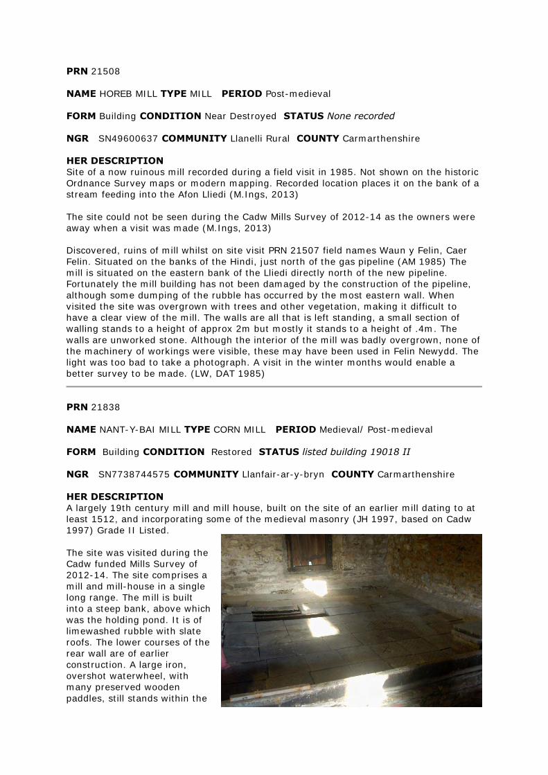
PRN 21508
NAME HOREB MILL TYPE MILL PERIOD Post-medieval
FORM Building CONDITION Near Destroyed STATUS None recorded
NGR SN49600637 COMMUNITY Llanelli Rural COUNTY Carmarthenshire
HER DESCRIPTION
Site of a now ruinous mill recorded during a field visit in 1985. Not shown on the historic
Ordnance Survey maps or modern mapping. Recorded location places it on the bank of a
stream feeding into the Afon Lliedi (M.Ings, 2013)
The site could not be seen during the Cadw Mills Survey of 2012-14 as the owners were
away when a visit was made (M.Ings, 2013)
Discovered, ruins of mill whilst on site visit PRN 21507 field names Waun y Felin, Caer
Felin. Situated on the banks of the Hindi, just north of the gas pipeline (AM 1985) The
mill is situated on the eastern bank of the Lliedi directly north of the new pipeline.
Fortunately the mill building has not been damaged by the construction of the pipeline,
although some dumping of the rubble has occurred by the most eastern wall. When
visited the site was overgrown with trees and other vegetation, making it difficult to
have a clear view of the mill. The walls are all that is left standing, a small section of
walling stands to a height of approx 2m but mostly it stands to a height of .4m. The
walls are unworked stone. Although the interior of the mill was badly overgrown, none of
the machinery of workings were visible, these may have been used in Felin Newydd. The
light was too bad to take a photograph. A visit in the winter months would enable a
better survey to be made. (LW, DAT 1985)
PRN 21838
NAME NANT-Y-BAI MILL TYPE CORN MILL PERIOD Medieval/ Post-medieval
FORM Building CONDITION Restored STATUS listed building 19018 II
NGR SN7738744575 COMMUNITY Llanfair-ar-y-bryn COUNTY Carmarthenshire
HER DESCRIPTION
A largely 19th century mill and mill house, built on the site of an earlier mill dating to at
least 1512, and incorporating some of the medieval masonry (JH 1997, based on Cadw
1997) Grade II Listed.
The site was visited during the
Cadw funded Mills Survey of
2012-14. The site comprises a
mill and mill-house in a single
long range. The mill is built
into a steep bank, above which
was the holding pond. It is of
limewashed rubble with slate
roofs. The lower courses of the
rear wall are of earlier
construction. A large iron,
overshot waterwheel, with
many preserved wooden
paddles, still stands within the
wheelpit against the western gable although the axle is now broken. The interior
machinery, including the pit-wheel and gearing, appears intact. A corn-drying kiln is built
into the northeast corner with a firebox and flue on the groundfloor below a drying
surface of perforated tiles on the first floor. Three pairs of mill stones were housed within
wooden hoppers on the first floor, supplied with grain from chutes from the second floor
above. The holding pond, behind and above the mill, is now a neighbour's lawn having
been filled in during the 1960s. This had caused a flooding problem to the rear of the
mill so the council have had to redirect the mill race. The race is still evident, in part, as
a hedge-side drainage ditch (M.Ings, 2013)
PRN 21931
NAME GWYNFE MILL TYPE CORN MILL PERIOD Post-medieval
FORM Documents CONDITION Near Destroyed STATUS None recorded
NGR SN72932197 COMMUNITY Llangadog COUNTY Carmarthenshire
HER DESCRIPTION
Site of a corn mill recorded on the historic Ordnance Survey maps, located alongside the
Afon Clydach. The buildings are no longer shown on modern mapping and the site can be
seen on a recent aerial photograph to be under woodland (M.Ings, 2013)
PRN 21948
NAME MELIN-PWLL-CALCH TYPE MILL PERIOD Post-medieval
FORM Documents CONDITION Near Destroyed STATUS None recorded
NGR SN76662862 COMMUNITY Llanddeusant COUNTY Carmarthenshire
HER DESCRIPTION
Melin-pwll-coch is recorded on the 1886 1st edition and 1906 2nd edition Ordnance
Survey maps a two-cell building standing on the southern bank of the Afon Clydach. Not
shown on modern mapping, presumed destroyed (M.Ings, 2012)
The site was visited during the Cadw funded Mills Survey of 2012-14. The recorded
location is at the base of a north-facing slope within a pasture field, on the southern
bank of a river. There are no structural remains and the current landowner said that
nothing survived of the mill when his father bought the farm some 78 years ago.
There is an earthwork, some 8.0m square and standing 0.25-0.30m high, which may
represent a building platform although the thick vegetation prevented any clarification.
Several exposed stones were in the vicinity. Upslope of the mill site is a possible pool,
now infilled or silted up, which appears to be fed by a watercourse running northwest -
southeast. These features are not recorded on the historical maps and it is uncertain
whether they have any association with the mill. It was also noted that there is a,
possibly natural, weir just upriver of the mill site (M.Ings, 2012)
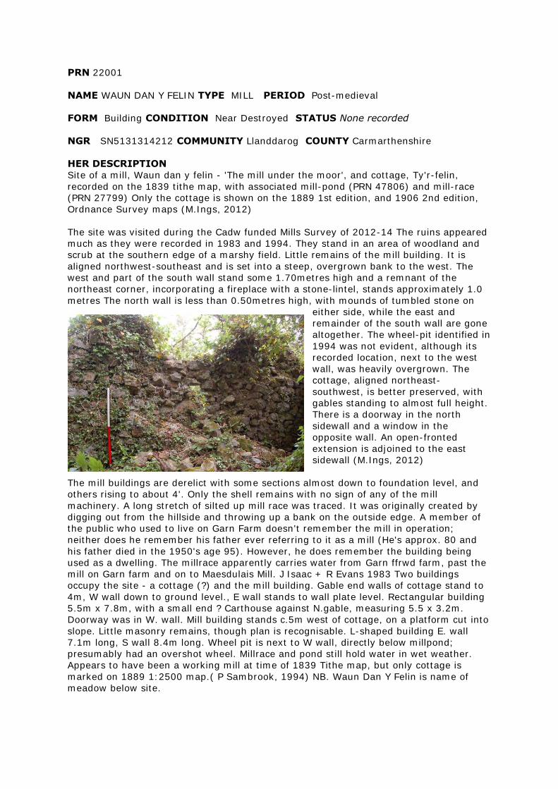
PRN 22001
NAME WAUN DAN Y FELIN TYPE MILL PERIOD Post-medieval
FORM Building CONDITION Near Destroyed STATUS None recorded
NGR SN5131314212 COMMUNITY Llanddarog COUNTY Carmarthenshire
HER DESCRIPTION
Site of a mill, Waun dan y felin - 'The mill under the moor', and cottage, Ty'r-felin,
recorded on the 1839 tithe map, with associated mill-pond (PRN 47806) and mill-race
(PRN 27799) Only the cottage is shown on the 1889 1st edition, and 1906 2nd edition,
Ordnance Survey maps (M.Ings, 2012)
The site was visited during the Cadw funded Mills Survey of 2012-14 The ruins appeared
much as they were recorded in 1983 and 1994. They stand in an area of woodland and
scrub at the southern edge of a marshy field. Little remains of the mill building. It is
aligned northwest-southeast and is set into a steep, overgrown bank to the west. The
west and part of the south wall stand some 1.70metres high and a remnant of the
northeast corner, incorporating a fireplace with a stone-lintel, stands approximately 1.0
metres The north wall is less than 0.50metres high, with mounds of tumbled stone on
either side, while the east and
remainder of the south wall are gone
altogether. The wheel-pit identified in
1994 was not evident, although its
recorded location, next to the west
wall, was heavily overgrown. The
cottage, aligned northeast-
southwest, is better preserved, with
gables standing to almost full height.
There is a doorway in the north
sidewall and a window in the
opposite wall. An open-fronted
extension is adjoined to the east
sidewall (M.Ings, 2012)
The mill buildings are derelict with some sections almost down to foundation level, and
others rising to about 4'. Only the shell remains with no sign of any of the mill
machinery. A long stretch of silted up mill race was traced. It was originally created by
digging out from the hillside and throwing up a bank on the outside edge. A member of
the public who used to live on Garn Farm doesn't remember the mill in operation;
neither does he remember his father ever referring to it as a mill (He's approx. 80 and
his father died in the 1950's age 95). However, he does remember the building being
used as a dwelling. The millrace apparently carries water from Garn ffrwd farm, past the
mill on Garn farm and on to Maesdulais Mill. J Isaac + R Evans 1983 Two buildings
occupy the site - a cottage (?) and the mill building. Gable end walls of cottage stand to
4m, W wall down to ground level., E wall stands to wall plate level. Rectangular building
5.5m x 7.8m, with a small end ? Carthouse against N.gable, measuring 5.5 x 3.2m.
Doorway was in W. wall. Mill building stands c.5m west of cottage, on a platform cut into
slope. Little masonry remains, though plan is recognisable. L-shaped building E. wall
7.1m long, S wall 8.4m long. Wheel pit is next to W wall, directly below millpond;
presumably had an overshot wheel. Millrace and pond still hold water in wet weather.
Appears to have been a working mill at time of 1839 Tithe map, but only cottage is
marked on 1889 1:2500 map.( P Sambrook, 1994) NB. Waun Dan Y Felin is name of
meadow below site.
PRN 22241
NAME MELIN-Y-GRAIG TYPE MILL/ COTTAGE PERIOD Post-medieval
FORM Building CONDITION Damaged STATUS None recorded
NGR SN4360040200 COMMUNITY Llanfihangel-ar-Arth COUNTY Carmarthenshire
HER DESCRIPTION
Melin-y-graig is recorded on the 1889 1st edition and 1905 2nd edition Ordnance Survey
maps, located on wooded slopes above the Afon Teifi. The building is still shown on
modern mapping but a field visit in 1983 recorded it to be derelict (M.Ings, 2012, from
various sources)
The site was visited during the Cadw funded Mills Survey of 2012-14. The building is now
largely destroyed with just the northern end gable, part of the eastern side wall and the
southeast corner surviving. The building was approximately 8.00m by 6.00m, aligned
north-south and of semi-dressed stone rubble with substantial, squared quoins.
No features were evident to identify the building as a mill - the interior is now obscured
by tumbled stone and vegetation, while vegetated mounds of stone abutt the gable
ends. The current landowner remembers it as a cottage that collapsed as a result of a
fire. A trackway was noted to the south and east of the building (M.Ings, 2012)
PRN 22433
NAME RHOSMAEN TYPE CORN MILL PERIOD Post-medieval
FORM Documents CONDITION Near Intact STATUS None recorded
NGR SN64122405 COMMUNITY Manordeilo and Salem COUNTY Carmarthenshire
HER DESCRIPTION
Site of a corn mill recorded on the historic Ordnance Survey maps near Rhosmaen House
to the northeast of Llandeilo. It is powered by a long mill-race (PRN 20434) diverted
from the Afon Dulais by a weir to the north of the mill. The mill is within a complex of
buildings, including a tannery, and still appears on modern mapping and looks intact on
recent aerial photographs (Ordnance Survey Next Perspectives, 2009) The mill-race is
also preserved, at least in part (M.Ings, 2013)
PRN 22438
NAME TREGEYB TYPE Mill PERIOD Post Medieval
EVIDENCE Documentary Evidence CONDITION Restored STATUS None recorded
NGR SN63222155 COMMUNITY Manordeilo and Salem COUNTY Carmarthenshire
HER DESCRIPTION
Site of a post-medieval corn mill, served by an extensive mill pond, recorded on the
historical Ordnance Survey maps (M.Ings, 2012)
Tregeyb stopped functioning as a mill before the 2nd World War and the original
machinery and wheel were removed. Modern maps suggest that recent development of
the area has impinged on the site and the mill pond appears filled in. The mill building
still stands and was restored in the 1980s, resembling a Welsh longhouse in style. A
post-medieval mill-wheel channel, connecting with a leat to the north of the mill, was
recorded during renovation work in 2004 (M.Ings, 2012, from various sources)
PRN 22442
NAME GURREY TYPE MILL PERIOD Post-medieval
FORM Documents CONDITION Near Destroyed STATUS None recorded
NGR SN62392351 COMMUNITY Manordeilo and Salem COUNTY Carmarthenshire
HER DESCRIPTION
Gurrey Mill is recorded on the 1886 1st edition and 1906 2nd edition Ordnance Survey
maps, depicted as two adjacent buildings within an area of woodland to the south of
Gurrey Manor. The site is no longer shown on modern mapping (M.Ings, 2012)
The site was visited during the Cadw Mills project of 2012-14. Very few structural
remains survive within an area of thick woodland and undergrowth. It appeared that a
remnant of the southwest corner of the more northerly building may survive, to a
maximum height of 0.45m. Heavy vegetation prevented a clear view of this and stone
tumble spread either side of the wall line. The area to the southwest of this is relatively
flat and defined by steep slopes to the northwest and southwest. This may represent a
building platform for the more southerly building although no structural remains were
evident. A discrete area of bricks was noted but it is unknown whether they are
associated with the recorded buildings. A stream runs to the northeast of the mill but no
obvious system of powering a mill is depicted on the historical maps or was evident on
the ground (M.Ings, 2012)
PRN 22501
NAME FELINDRE MILL TYPE CORN MILL PERIOD Post-medieval
FORM Documents CONDITION Intact STATUS None recorded
NGR SN68743044 COMMUNITY Llansadwrn COUNTY Carmarthenshire
HER DESCRIPTION
Site of a corn mill recorded on the 1887 1st edition and 1906 2nd edition Ordnance
Survey maps, powered by a long mill-race diverted off the river to the north. Still shown
on modern mapping and appears from recent aerial photography (Ordnance Survey Next
Perspectives, 2009) to possibly be converted as a dwelling (M.Ings, 2013)
PRN 22528
NAME BISHOP'S MILL TYPE MILL/ corn mill PERIOD Post-medieval
FORM Complex CONDITION Various/ Damaged STATUS None recorded
NGR SN55532652 COMMUNITY Llanfynydd COUNTY Carmarthenshire
HER DESCRIPTION
Bishop's Corn Mill is recorded on the historic Ordnance Survey maps, as part of a
complex of buildings and standing at right-angles to a saw mill. Both are powered by
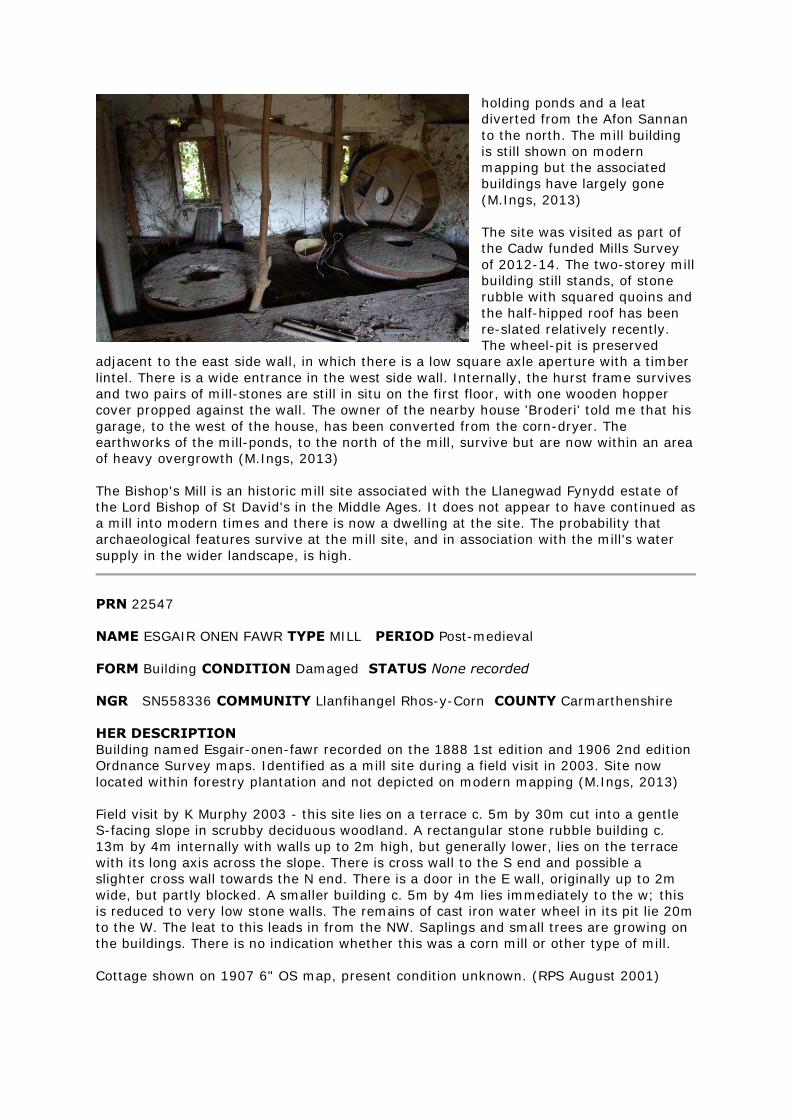
holding ponds and a leat
diverted from the Afon Sannan
to the north. The mill building
is still shown on modern
mapping but the associated
buildings have largely gone
(M.Ings, 2013)
The site was visited as part of
the Cadw funded Mills Survey
of 2012-14. The two-storey mill
building still stands, of stone
rubble with squared quoins and
the half-hipped roof has been
re-slated relatively recently.
The wheel-pit is preserved
adjacent to the east side wall, in which there is a low square axle aperture with a timber
lintel. There is a wide entrance in the west side wall. Internally, the hurst frame survives
and two pairs of mill-stones are still in situ on the first floor, with one wooden hopper
cover propped against the wall. The owner of the nearby house 'Broderi' told me that his
garage, to the west of the house, has been converted from the corn-dryer. The
earthworks of the mill-ponds, to the north of the mill, survive but are now within an area
of heavy overgrowth (M.Ings, 2013)
The Bishop's Mill is an historic mill site associated with the Llanegwad Fynydd estate of
the Lord Bishop of St David's in the Middle Ages. It does not appear to have continued as
a mill into modern times and there is now a dwelling at the site. The probability that
archaeological features survive at the mill site, and in association with the mill's water
supply in the wider landscape, is high.
PRN 22547
NAME ESGAIR ONEN FAWR TYPE MILL PERIOD Post-medieval
FORM Building CONDITION Damaged STATUS None recorded
NGR SN558336 COMMUNITY Llanfihangel Rhos-y-Corn COUNTY Carmarthenshire
HER DESCRIPTION
Building named Esgair-onen-fawr recorded on the 1888 1st edition and 1906 2nd edition
Ordnance Survey maps. Identified as a mill site during a field visit in 2003. Site now
located within forestry plantation and not depicted on modern mapping (M.Ings, 2013)
Field visit by K Murphy 2003 - this site lies on a terrace c. 5m by 30m cut into a gentle
S-facing slope in scrubby deciduous woodland. A rectangular stone rubble building c.
13m by 4m internally with walls up to 2m high, but generally lower, lies on the terrace
with its long axis across the slope. There is cross wall to the S end and possible a
slighter cross wall towards the N end. There is a door in the E wall, originally up to 2m
wide, but partly blocked. A smaller building c. 5m by 4m lies immediately to the w; this
is reduced to very low stone walls. The remains of cast iron water wheel in its pit lie 20m
to the W. The leat to this leads in from the NW. Saplings and small trees are growing on
the buildings. There is no indication whether this was a corn mill or other type of mill.
Cottage shown on 1907 6" OS map, present condition unknown. (RPS August 2001)
PRN 22718
NAME WHITLAND TYPE CORN MILL PERIOD Post-medieval
FORM Documents CONDITION Near Destroyed STATUS None recorded
NGR SN20321665 COMMUNITY Whitland COUNTY Carmarthenshire
HER DESCRIPTION
Corn mill recorded on the historic Ordnance Survey maps but no longer shown on
modern mapping. Recent aerial photographs (Ordnance Survey Next Perspectives, 2009)
indicate that the site has been destroyed, with a possible caravan park developed on the
site (M.Ings, 2013)
PRN 23335
NAME CWM FELIN BOETH MILL TYPE CORN MILL PERIOD Post-medieval
FORM Building CONDITION Intact STATUS None recorded
NGR SN1919119136 COMMUNITY Llanboidy COUNTY Carmarthenshire
HER DESCRIPTION
Site of a corn mill recorded on the 1890 1st edition and 1907 2nd edition Ordnance
Survey maps, powered by a mill-race diverted from the river to the southwest. Still
shown on modern mapping and recent aerial photographs (Ordnance Survey Next
Perspectives, 2009) indicate the building to be intact, possibly converted as a house
(M.Ings, 2013)
PRN 23904
NAME DULAIS MILL TYPE MILL PERIOD Post-medieval
FORM Documents CONDITION STATUS None recorded
NGR SN48860153 COMMUNITY Cefn Sidan COUNTY Carmarthenshire
HER DESCRIPTION
Same as PRN 21471
PRN 25240
NAME WHITE MILL TYPE Water Mill PERIOD Post Medieval
EVIDENCE Building CONDITION Destroyed STATUS None recorded
NGR SN6240021400 COMMUNITY Dyffryn Cennen COUNTY Carmarthenshire
HER DESCRIPTION
Site of a corn mill, with extensive mill pond, recorded on the 1887 1st edition and 1906
2nd edition Ordnance Survey maps within Ffair-fach. Modern mapping shows the location
of the mill to be now beneath a housing development (M.Ings, 2012, from various
sources)
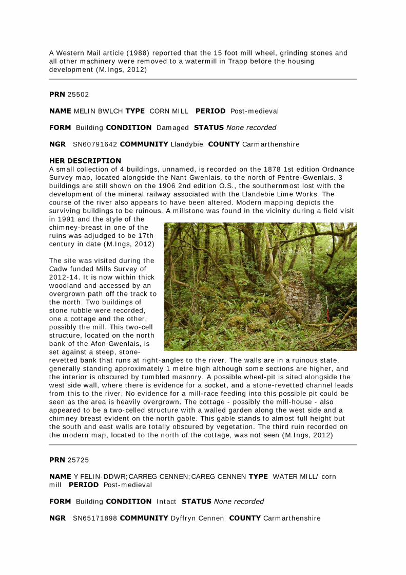
A Western Mail article (1988) reported that the 15 foot mill wheel, grinding stones and
all other machinery were removed to a watermill in Trapp before the housing
development (M.Ings, 2012)
PRN 25502
NAME MELIN BWLCH TYPE CORN MILL PERIOD Post-medieval
FORM Building CONDITION Damaged STATUS None recorded
NGR SN60791642 COMMUNITY Llandybie COUNTY Carmarthenshire
HER DESCRIPTION
A small collection of 4 buildings, unnamed, is recorded on the 1878 1st edition Ordnance
Survey map, located alongside the Nant Gwenlais, to the north of Pentre-Gwenlais. 3
buildings are still shown on the 1906 2nd edition O.S., the southernmost lost with the
development of the mineral railway associated with the Llandebie Lime Works. The
course of the river also appears to have been altered. Modern mapping depicts the
surviving buildings to be ruinous. A millstone was found in the vicinity during a field visit
in 1991 and the style of the
chimney-breast in one of the
ruins was adjudged to be 17th
century in date (M.Ings, 2012)
The site was visited during the
Cadw funded Mills Survey of
2012-14. It is now within thick
woodland and accessed by an
overgrown path off the track to
the north. Two buildings of
stone rubble were recorded,
one a cottage and the other,
possibly the mill. This two-cell
structure, located on the north
bank of the Afon Gwenlais, is
set against a steep, stone-
revetted bank that runs at right-angles to the river. The walls are in a ruinous state,
generally standing approximately 1 metre high although some sections are higher, and
the interior is obscured by tumbled masonry. A possible wheel-pit is sited alongside the
west side wall, where there is evidence for a socket, and a stone-revetted channel leads
from this to the river. No evidence for a mill-race feeding into this possible pit could be
seen as the area is heavily overgrown. The cottage - possibly the mill-house - also
appeared to be a two-celled structure with a walled garden along the west side and a
chimney breast evident on the north gable. This gable stands to almost full height but
the south and east walls are totally obscured by vegetation. The third ruin recorded on
the modern map, located to the north of the cottage, was not seen (M.Ings, 2012)
PRN 25725
NAME Y FELIN-DDWR;CARREG CENNEN;CAREG CENNEN TYPE WATER MILL/ corn
mill PERIOD Post-medieval
FORM Building CONDITION Intact STATUS None recorded
NGR SN65171898 COMMUNITY Dyffryn Cennen COUNTY Carmarthenshire
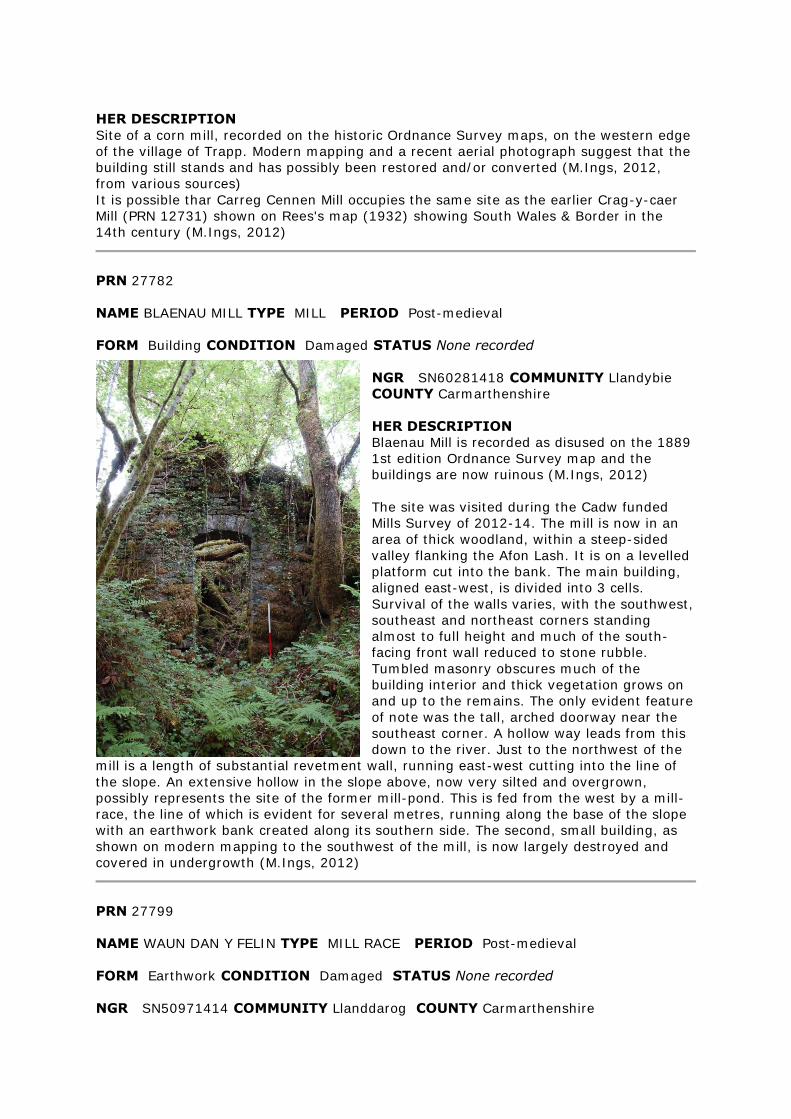
HER DESCRIPTION
Site of a corn mill, recorded on the historic Ordnance Survey maps, on the western edge
of the village of Trapp. Modern mapping and a recent aerial photograph suggest that the
building still stands and has possibly been restored and/or converted (M.Ings, 2012,
from various sources)
It is possible thar Carreg Cennen Mill occupies the same site as the earlier Crag-y-caer
Mill (PRN 12731) shown on Rees's map (1932) showing South Wales & Border in the
14th century (M.Ings, 2012)
PRN 27782
NAME BLAENAU MILL TYPE MILL PERIOD Post-medieval
FORM Building CONDITION Damaged STATUS None recorded
NGR SN60281418 COMMUNITY Llandybie
COUNTY Carmarthenshire
HER DESCRIPTION
Blaenau Mill is recorded as disused on the 1889
1st edition Ordnance Survey map and the
buildings are now ruinous (M.Ings, 2012)
The site was visited during the Cadw funded
Mills Survey of 2012-14. The mill is now in an
area of thick woodland, within a steep-sided
valley flanking the Afon Lash. It is on a levelled
platform cut into the bank. The main building,
aligned east-west, is divided into 3 cells.
Survival of the walls varies, with the southwest,
southeast and northeast corners standing
almost to full height and much of the south-
facing front wall reduced to stone rubble.
Tumbled masonry obscures much of the
building interior and thick vegetation grows on
and up to the remains. The only evident feature
of note was the tall, arched doorway near the
southeast corner. A hollow way leads from this
down to the river. Just to the northwest of the
mill is a length of substantial revetment wall, running east-west cutting into the line of
the slope. An extensive hollow in the slope above, now very silted and overgrown,
possibly represents the site of the former mill-pond. This is fed from the west by a mill-
race, the line of which is evident for several metres, running along the base of the slope
with an earthwork bank created along its southern side. The second, small building, as
shown on modern mapping to the southwest of the mill, is now largely destroyed and
covered in undergrowth (M.Ings, 2012)
PRN 27799
NAME WAUN DAN Y FELIN TYPE MILL RACE PERIOD Post-medieval
FORM Earthwork CONDITION Damaged STATUS None recorded
NGR SN50971414 COMMUNITY Llanddarog COUNTY Carmarthenshire
HER DESCRIPTION
Leat that carried water 350m across fields of Garn Farm from stream to Ty'r Felin Mill.
Both leat and mill appear to have been functioning at time of 1839 Tithe Map but do not
appear on 1889 1:2500 map. (P.Sambrook 1994)
The site was visited during the Cadw funded Mills Survey of 2012-14. The line of the
mill-race is preserved, although overgrown in parts, as an earthwork some 2 metres in
width with a bank on its north side. It follows the contour around the side of the hillslope
to the west of Waun Dan y Felin (PRN 22001), where it runs into the mill-pond
(PRN47806) (M.Ings, 2012)
PRN 28355
NAME CWMDU MILL TYPE MILL/ corn mill PERIOD Post-medieval
FORM Building CONDITION Near Destroyed STATUS None recorded
NGR SN637301 COMMUNITY Talley COUNTY Carmarthenshire
HER DESCRIPTION
Cwmdu is recorded on the 1888 1st edition Ordnance Survey map as a corn mill, with
associated mill race (PRN 18129) and pond. There appear to be four buildings in the mill
complex. By the time of the 1906 2nd edition map the mill is marked as disused and
only three buildings are recorded. Modern mapping depicts two ruinous buildings, the
pond is gone and the mill race is marked as a drain (M.Ings, 2012, from various
sources)
The site was visited during the Cadw funded Mills Survey of 2012-14, although access
was restricted as the landowner could not be found. The ruins of three buildings were
evident, located either side of a farm trackway. The most complete of these was on the
north side of the track - a rectilinear building with the possible remnant of a chimney
breast apparent in the western end wall (standing approximately 1.50m), suggesting
that this may have been the mill-house. The southern side wall has completely gone,
and the eastern end wall was reduced to stone tumble. Two short sections of standing,
partially dressed masonry - remnants of the two side walls - to the south of the track are
all that remain of the mill, potentially partially demolished by the establishment of the
trackway. They stand within scrubby woodland and the area of the mill pond appeared
now filled in, although the tail-race was preserved, running down to the remains of a
third building The perimeter of this small square building is discernible but the interior
appears filled-in and the whole is covered by vegetation, including two trees (M.Ings,
2012)
PRN 28370
NAME MAES-Y-FELIN TYPE MILL/ cottage PERIOD Post-medieval
FORM Documents CONDITION Not Known/ Near Destroyed STATUS None
recorded
NGR SN6538431686 COMMUNITY Talley COUNTY Carmarthenshire
HER DESCRIPTION
Maes-y-felin is the name given to a building recorded on the 1888 1st edition and 1906
2nd edition Ordnance Survey maps. It is located within an enclosure by the side of a
stream and is accessed by a trackway to the southeast. The site was not recorded on the
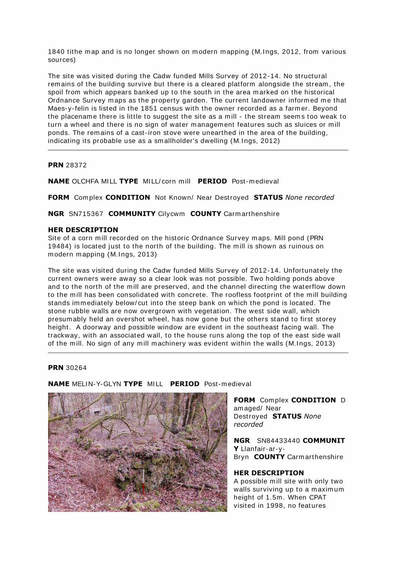
1840 tithe map and is no longer shown on modern mapping (M.Ings, 2012, from various
sources)
The site was visited during the Cadw funded Mills Survey of 2012-14. No structural
remains of the building survive but there is a cleared platform alongside the stream, the
spoil from which appears banked up to the south in the area marked on the historical
Ordnance Survey maps as the property garden. The current landowner informed me that
Maes-y-felin is listed in the 1851 census with the owner recorded as a farmer. Beyond
the placename there is little to suggest the site as a mill - the stream seems too weak to
turn a wheel and there is no sign of water management features such as sluices or mill
ponds. The remains of a cast-iron stove were unearthed in the area of the building,
indicating its probable use as a smallholder's dwelling (M.Ings, 2012)
PRN 28372
NAME OLCHFA MILL TYPE MILL/corn mill PERIOD Post-medieval
FORM Complex CONDITION Not Known/ Near Destroyed STATUS None recorded
NGR SN715367 COMMUNITY Cilycwm COUNTY Carmarthenshire
HER DESCRIPTION
Site of a corn mill recorded on the historic Ordnance Survey maps. Mill pond (PRN
19484) is located just to the north of the building. The mill is shown as ruinous on
modern mapping (M.Ings, 2013)
The site was visited during the Cadw funded Mills Survey of 2012-14. Unfortunately the
current owners were away so a clear look was not possible. Two holding ponds above
and to the north of the mill are preserved, and the channel directing the waterflow down
to the mill has been consolidated with concrete. The roofless footprint of the mill building
stands immediately below/cut into the steep bank on which the pond is located. The
stone rubble walls are now overgrown with vegetation. The west side wall, which
presumably held an overshot wheel, has now gone but the others stand to first storey
height. A doorway and possible window are evident in the southeast facing wall. The
trackway, with an associated wall, to the house runs along the top of the east side wall
of the mill. No sign of any mill machinery was evident within the walls (M.Ings, 2013)
PRN 30264
NAME MELIN-Y-GLYN TYPE MILL PERIOD Post-medieval
FORM Complex CONDITION D
amaged/ Near
Destroyed STATUS None
recorded
NGR SN84433440 COMMUNIT
Y Llanfair-ar-y-
Bryn COUNTY Carmarthenshire
HER DESCRIPTION
A possible mill site with only two
walls surviving up to a maximum
height of 1.5m. When CPAT
visited in 1998, no features
associated with mills were visible ( JH, 11.03.2000 based on CPAT 1998)
The site was visited as part of the Cadw funded Mills Survey of 2012-14. Melyn-y-glyn is
located within Halfway Forest, below a steep bank on which runs a forest track, on a
platform above the Nant y Dresglen. The ruinous building, measuring approximately 12
metres northeast-southwest by 7 metres northwest-southeast has only the northwest
and southwest facing walls surviving, some 1.0-1.5 metres high. Remnant of a possible
wheel-pit was noted adjacent to the southwest facing wall but any other features have
been lost or are obscured by stone tumble and/or thick vegetation (M.Ings, 2013)
Three buildings shown on 1964 ed OS map. 1st and 2nd not available for consultation
(JH June 1995) Mill site marked on 1905 Ordnance Survey map. Two walls survive, 7m
NE-SW x 7m NW-SE. Maximum height of 1.5m. No sign of any features associated with a
mill. Generally in poor condition. Trees growing from walls and close to walls (CPAT
1998)
PRN 30682
NAME BANC-Y-FELIN TYPE MILL RACE PERIOD Post-medieval
FORM Earthwork CONDITION Damaged STATUS None recorded
NGR SN2991936354 COMMUNITY Cenarth COUNTY Carmarthenshire
HER DESCRIPTION
Mill race connected with mill PRN 12627. The mill race still survives although heavily
silted. At least parts of it were stone lined. JH 1995 based on NJp 1995
The site was visited during the Cadw funded Mills project of 2012-13. The mill-race is
still clearly evident where it cuts across the hillslope in the pasture field to the east of
the mill building. It appears silted and is grassed over (M.Ings, 2012)
PRN 33304
NAME RICKETT'S MILL TYPE MILL RACE PERIOD Post-medieval
FORM Buried Feature CONDITION Not Known/ Near Destroyed STATUS None
recorded
NGR SN34212180 COMMUNITY Abernant COUNTY Carmarthenshire
HER DESCRIPTION
A Mill race coming off the Cynnen river,associated with Felin Ricket (PRN 9909) ( R.J.
27/9/96) It was recorded in 1984 that the race was infilled to create a farm track
(M.Ings, 2013)
PRN 35382
NAME CORN MILL; ABERGORLECH TYPE MILL PERIOD Post-medieval
FORM Documents CONDITION Damaged STATUS None recorded
NGR SN58483361 COMMUNITY Llanfihangel Rhos-y-Corn
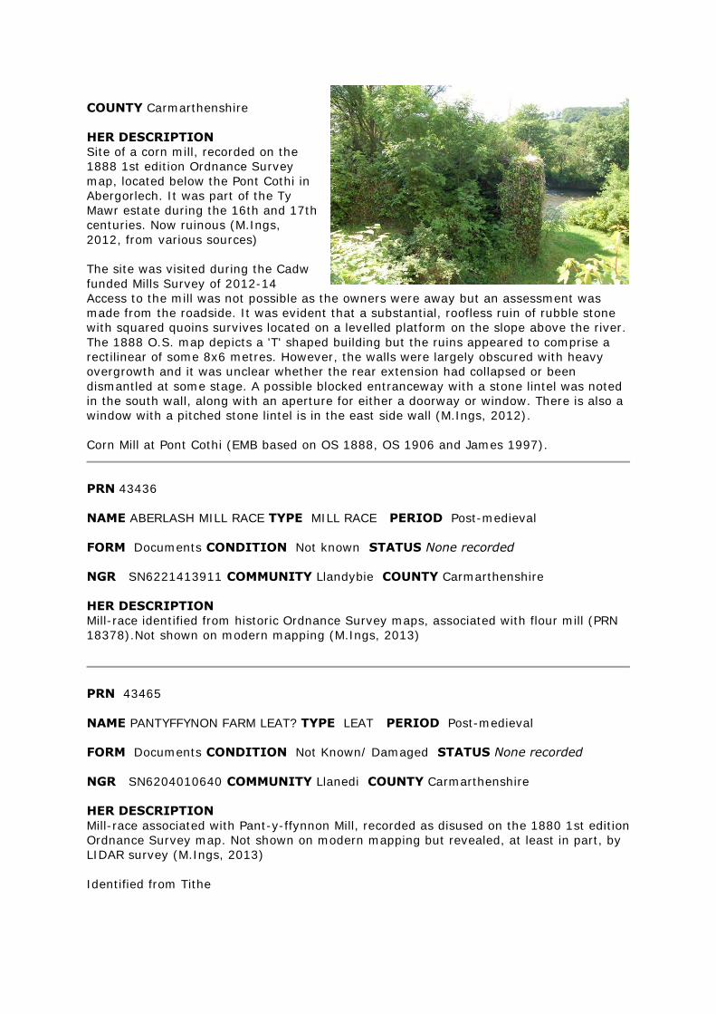
COUNTY Carmarthenshire
HER DESCRIPTION
Site of a corn mill, recorded on the
1888 1st edition Ordnance Survey
map, located below the Pont Cothi in
Abergorlech. It was part of the Ty
Mawr estate during the 16th and 17th
centuries. Now ruinous (M.Ings,
2012, from various sources)
The site was visited during the Cadw
funded Mills Survey of 2012-14
Access to the mill was not possible as the owners were away but an assessment was
made from the roadside. It was evident that a substantial, roofless ruin of rubble stone
with squared quoins survives located on a levelled platform on the slope above the river.
The 1888 O.S. map depicts a 'T' shaped building but the ruins appeared to comprise a
rectilinear of some 8x6 metres. However, the walls were largely obscured with heavy
overgrowth and it was unclear whether the rear extension had collapsed or been
dismantled at some stage. A possible blocked entranceway with a stone lintel was noted
in the south wall, along with an aperture for either a doorway or window. There is also a
window with a pitched stone lintel is in the east side wall (M.Ings, 2012).
Corn Mill at Pont Cothi (EMB based on OS 1888, OS 1906 and James 1997).
PRN 43436
NAME ABERLASH MILL RACE TYPE MILL RACE PERIOD Post-medieval
FORM Documents CONDITION Not known STATUS None recorded
NGR SN6221413911 COMMUNITY Llandybie COUNTY Carmarthenshire
HER DESCRIPTION
Mill-race identified from historic Ordnance Survey maps, associated with flour mill (PRN
18378).Not shown on modern mapping (M.Ings, 2013)
PRN 43465
NAME PANTYFFYNON FARM LEAT? TYPE LEAT PERIOD Post-medieval
FORM Documents CONDITION Not Known/ Damaged STATUS None recorded
NGR SN6204010640 COMMUNITY Llanedi COUNTY Carmarthenshire
HER DESCRIPTION
Mill-race associated with Pant-y-ffynnon Mill, recorded as disused on the 1880 1st edition
Ordnance Survey map. Not shown on modern mapping but revealed, at least in part, by
LIDAR survey (M.Ings, 2013)
Identified from Tithe
PRN 43466
NAME PANTYFFYNON MILL AND ENCLOSURE TYPE MILL PERIOD Post-medieval
FORM Documents CONDITION Not Known/ Near Destroyed STATUS None
recorded
NGR SN6212210624 COMMUNITY Llanedi COUNTY Carmarthenshire
HER DESCRIPTION
Site of a mill, with associated mill-race (PRN 43465), shown as disused on the 1880 1st
edition Ordnance Survey map. The site is no longer shown on modern mapping and the
area now appears under grass on recent aerial photographs (Ordnance Survey Next
Perspectives, 2009) (M.Ings, 2013)
PRN 44017
NAME ABERLASH WEIR TYPE WEIR PERIOD Post-medieval
FORM Documents CONDITION Near Destroyed STATUS None recorded
NGR SN6221513921 COMMUNITY Llandybie COUNTY Carmarthenshire
HER DESCRIPTION
Weir shown on 1st edition Ordnance Survey diverting water into mill-race (PRN 43436)
to power flour mill (PRN 18378) Not shown on modern mapping (M.Ings, 2013)
mostly destroyed sections remaining
PRN 47806
NAME WAUN DAN Y FELIN TYPE MILL POND PERIOD Post Med
FORM Earthwork CONDITION Damaged STATUS None recorded
NGR SN51301422 COMMUNITY Llanddarog COUNTY Carmarthenshire
HER DESCRIPTION
Site of a mill-pond associated with Waun Dan Y Felin (PRN 22001), recorded on the 1839
tithe map (M.Ings, 2012)
The site was visited during the Cadw funded Mills Survey of 2012-13. It is located above
and to the west of Waun dan y Felin (PRN 22001) The mill-race (PRN 27799) enters the
pond at its western end and the eastern end is obscured by thick vegetation. The pond is
preserved as a shallow, grassed-over depression some 6.0metres in width (M.Ings,
2012) This is the probable site of the mill pond, as depicted on the parish tithe map of
1846. The mill race (PRN 27799) opens out into a shallow, roughly circular depression at
this point. There is no water contained in it. The earthwork is turf covered, and generally
in good condition.
PRN 48054
NAME KEVYNWAYS; FELIN RHOS TYPE mill race PERIOD Post-Medieval
FORM Earthwork CONDITION Near Intact STATUS None recorded
NGR SN64794473 COMMUNITY Cynwyl Gaeo COUNTY Carmarthenshire
HER DESCRIPTION
Mill-race recorded on the historic Ordnance Survey maps associated with Felin Rhos
(PRN 5121)It may have earlier, medieval origins as part of the 15th century Kevynways
fulling mill complex (PRN 12946) (M.Ings, 2013)
The site was seen and recorded in 2003. The whole length of the race survives, and for
the most part is a clear earthwork with stone walling along parts of the west side. At its
south end the mill-race feeds into a pond (PRN 48055)
PRN 48055
NAME KEVYNWAYS; FELIN RHOS TYPE mill pond PERIOD Post-Medieval
FORM Earthwork CONDITION Damaged STATUS None recorded
NGR SN64814474 COMMUNITY Cynwyl Gaeo COUNTY Carmarthenshire
HER DESCRIPTION
Mill-pond associated with 19th century Felin Rhos corn mill (PRN 5121) It may have
earlier origins as part of 15th century Kevynways fulling mill (PRN 12946). Recorded on
the historic Ordnance Survey maps, linked to mill-race PRN 48054) (M.Ings, 2013)
The site was seen and recorded in 2003. The banks are ill defined but the overall shape
is roughly oval and is a close match with what is seen on the 1891 and 1905 OS maps.
Although there is no standing water, the base of the pond is very muddy and boggy.
PRN 61009
NAME ABERGWENLAIS MILL TYPE MILL/ corn mill PERIOD Post-medieval
FORM Building CONDITION Near Intact STATUS listed building 16989 II
NGR SN7592038984 COMMUNITY Cilycwm COUNTY Carmarthenshire
HER DESCRIPTION
Corn mill dating to the late 18th-early 19th century recorded on the 1st and 2nd edition
Ordnance Survey maps. Powered by a mill-race diverted by a weir from the river to the
northeast. The race was ruined by flooding in the early 20th century and the mill fell into
disuse soon afterward. The building is now Grade II listed (Cadw ref: 16989) (M.Ings,
2013, from various sources)
PRN 102933
NAME PLAS-NEWYDD MILL TYPE WEIR PERIOD Post-Medieval
FORM Other Structure CONDITION Intact STATUS None recorded
NGR SN57720854 COMMUNITY Llanedi COUNTY Carmarthenshire
HER DESCRIPTION
Weir on the Afon Gwili built to divert water into the mill-race (PRN 102934) used to
power Plas-Newydd corn mill (PRN 16783) Recorded on the 1879 1st edition and 1906 2nd edition Ordnance Survey maps (M.Ings, 2012, from various sources)
The weir was seen during the Cadw funded mills project of 2012-14. It is intact,
constructed from undressed stone blocks set into the river (M.Ings, 2012)
PRN 102934
NAME PLAS-NEWYDD MILL TYPE MILL RACE PERIOD Post-Medieval
FORM Multiple CONDITION Near Intact STATUS None recorded
NGR SN57780849 COMMUNITY Llanedi COUNTY Carmarthenshire
HER DESCRIPTION
Mill-race diverted from the Afon Gwili used to power Plas-Newydd corn mill (PRN 16783)
It is recorded on the 1879 1st edition and 1906 2nd edition (labelled as 'Old Mill Race')
Ordnance Survey maps, diverted by weir (PRN 102933) and crossing over the river on
an aqueduct (PRN 102936) before reaching the mill-pond (PRN 102935) to the west of the mill (M.Ings, 2012)
The site was visited during the Cadw funded Mills project of 2012-13. The mill-race is
evident at the point where it is diverted from the river and there is a short length of
stone wall fronting the water. As it heads southeast, alongside the river, the race
comprises an infilled/silted footpath before disappearing into impenetrable woodland. It
is traceable again as it reaches the northern side of the aqueduct, recorded as a
vegetated and silted earthwork now some 1.00metre wide and 0.35 metres deep. On the
eastern side of the river the line of the mill-race is clear as a levelled path cut into the
contour of the wooded bank, leading to the mill-pond (M.Ings, 2012)
PRN 102935
NAME PLAS-NEWYDD MILL TYPE MILL POND PERIOD Post-Medieval
FORM Topography CONDITION Damaged STATUS None recorded
NGR SN57760835 COMMUNITY Llanedi COUNTY Carmarthenshire
HER DESCRIPTION
Site of a mill-pond shown on the 1879 1st edition and 1906 2nd edition (where it is
labelled as 'Old Mill Pond') Ordnance Survey maps at Plas-newydd corn mill (PRN
16783). It is linked to a mill-race (PRN 102934) diverted from the Afon Gwili. The pond
is not depicted on modern mapping (M.Ings, 2012, from various sources).
The site was visited during the Cadw funded Mills project of 2012-14. It was noted that
the area of the mill-pond has now been infilled and grassed over as a lawn and orchard
(M.Ings, 2012
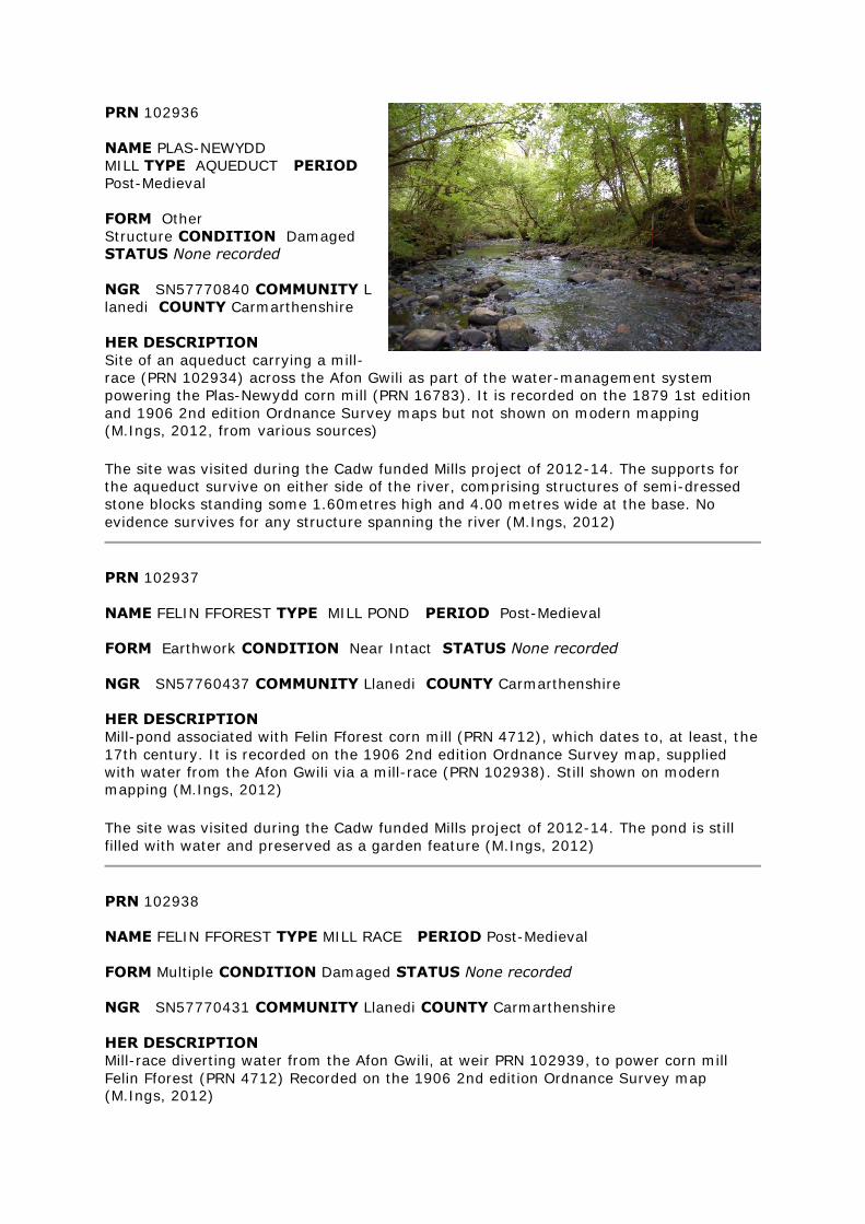
PRN 102936
NAME PLAS-NEWYDD
MILL TYPE AQUEDUCT PERIOD
Post-Medieval
FORM Other
Structure CONDITION Damaged
STATUS None recorded
NGR SN57770840 COMMUNITY L
lanedi COUNTY Carmarthenshire
HER DESCRIPTION
Site of an aqueduct carrying a mill-
race (PRN 102934) across the Afon Gwili as part of the water-management system
powering the Plas-Newydd corn mill (PRN 16783). It is recorded on the 1879 1st edition
and 1906 2nd edition Ordnance Survey maps but not shown on modern mapping (M.Ings, 2012, from various sources)
The site was visited during the Cadw funded Mills project of 2012-14. The supports for
the aqueduct survive on either side of the river, comprising structures of semi-dressed
stone blocks standing some 1.60metres high and 4.00 metres wide at the base. No
evidence survives for any structure spanning the river (M.Ings, 2012)
PRN 102937
NAME FELIN FFOREST TYPE MILL POND PERIOD Post-Medieval
FORM Earthwork CONDITION Near Intact STATUS None recorded
NGR SN57760437 COMMUNITY Llanedi COUNTY Carmarthenshire
HER DESCRIPTION
Mill-pond associated with Felin Fforest corn mill (PRN 4712), which dates to, at least, the
17th century. It is recorded on the 1906 2nd edition Ordnance Survey map, supplied
with water from the Afon Gwili via a mill-race (PRN 102938). Still shown on modern mapping (M.Ings, 2012)
The site was visited during the Cadw funded Mills project of 2012-14. The pond is still
filled with water and preserved as a garden feature (M.Ings, 2012)
PRN 102938
NAME FELIN FFOREST TYPE MILL RACE PERIOD Post-Medieval
FORM Multiple CONDITION Damaged STATUS None recorded
NGR SN57770431 COMMUNITY Llanedi COUNTY Carmarthenshire
HER DESCRIPTION
Mill-race diverting water from the Afon Gwili, at weir PRN 102939, to power corn mill
Felin Fforest (PRN 4712) Recorded on the 1906 2nd edition Ordnance Survey map (M.Ings, 2012)
The site was visited during the Cadw funded Mills Survey of 2012-14. The stretch of the
mill-race leading from the river to the mill-pond (PRN 102937) has been infilled,
although its stone-lined entrance is still preserved where there was once a sluice
gate.The tail-race, beyond the wheel-pit, is preserved as a steep-sided drain that still
carries water (M.Ings, 2012)
PRN 102939
NAME FELIN FFOREST TYPE WEIR PERIOD Post-Medieval
FORM Other Structure CONDITION Intact STATUS None recorded
NGR SN57740447 COMMUNITY Llanedi COUNTY Carmarthenshire
HER DESCRIPTION
Weir recorded on the 1906 2nd edition Ordnance Survey map, used to help divert water
from the Afon Gwili to the mill-race (PRN 102938) feeding Felin Ffiorest corn mill (PRN 4712) (M.Ings, 2012)
The site was visited during the Cadw funded Mills Survey of 2012-14 The weir is
preserved, comprising an artificial bank, aligned north-south, of squared and rounded
stones, creating a separate channel to feed into the mill-race (M.Ings, 2012)
PRN 102940
NAME LLANLLWCH MILL TYPE MILL POND PERIOD Post-Medieval
FORM Earthwork CONDITION Damaged STATUS None recorded
NGR SN38811887 COMMUNITY Carmarthen COUNTY Carmarthenshire
HER DESCRIPTION
Mill-pond associated with Llanllwch corn mill (PRN 9954), recorded on the 1890 1st and
1906 2nd edition Ordnance Survey maps. Its outline is still depicted on modern mapping but shown to be dry (M.Ings, 2012)
The site was visited during the Cadw funded Mills Survey of 2012-14. The mill pond is
now infilled and covered with vegetation but remnant of its southern bank remains
preserved (M.Ings, 2012)
PRN 102941
NAME LLANLLWCH MILL TYPE MILL RACE PERIOD Post-Medieval
FORM Earthwork CONDITION Damaged STATUS None recorded
NGR SN38731879 COMMUNITY Carmarthen COUNTY Carmarthenshire
HER DESCRIPTION
Mill-race associated with Llanllwch corn mill (PRN 9954), recorded on the 1890 1st and
1906 2nd edition Ordnance Survey maps. Shown on modern mapping as a drain (M.Ings, 2012)
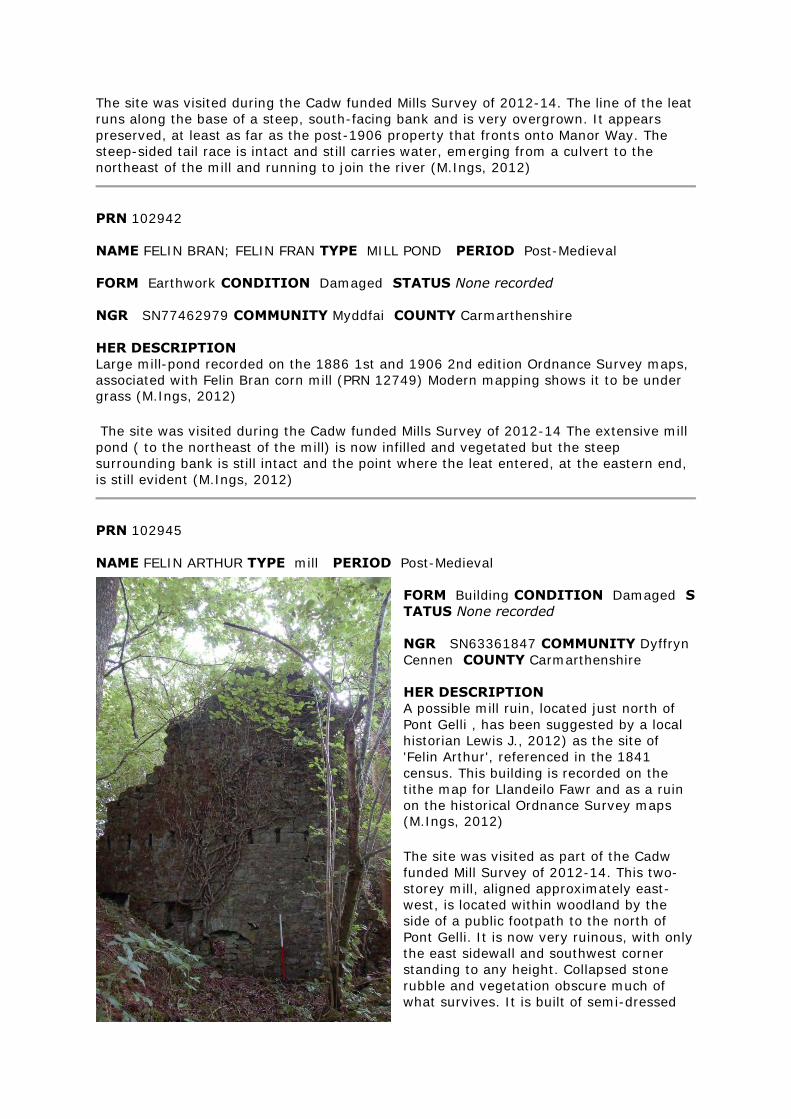
The site was visited during the Cadw funded Mills Survey of 2012-14. The line of the leat
runs along the base of a steep, south-facing bank and is very overgrown. It appears
preserved, at least as far as the post-1906 property that fronts onto Manor Way. The
steep-sided tail race is intact and still carries water, emerging from a culvert to the
northeast of the mill and running to join the river (M.Ings, 2012)
PRN 102942
NAME FELIN BRAN; FELIN FRAN TYPE MILL POND PERIOD Post-Medieval
FORM Earthwork CONDITION Damaged STATUS None recorded
NGR SN77462979 COMMUNITY Myddfai COUNTY Carmarthenshire
HER DESCRIPTION
Large mill-pond recorded on the 1886 1st and 1906 2nd edition Ordnance Survey maps,
associated with Felin Bran corn mill (PRN 12749) Modern mapping shows it to be under grass (M.Ings, 2012)
The site was visited during the Cadw funded Mills Survey of 2012-14 The extensive mill
pond ( to the northeast of the mill) is now infilled and vegetated but the steep
surrounding bank is still intact and the point where the leat entered, at the eastern end,
is still evident (M.Ings, 2012)
PRN 102945
NAME FELIN ARTHUR TYPE mill PERIOD Post-Medieval
FORM Building CONDITION Damaged S
TATUS None recorded
NGR SN63361847 COMMUNITY Dyffryn
Cennen COUNTY Carmarthenshire
HER DESCRIPTION
A possible mill ruin, located just north of
Pont Gelli , has been suggested by a local
historian Lewis J., 2012) as the site of
'Felin Arthur', referenced in the 1841
census. This building is recorded on the
tithe map for Llandeilo Fawr and as a ruin
on the historical Ordnance Survey maps (M.Ings, 2012)
The site was visited as part of the Cadw
funded Mill Survey of 2012-14. This two-
storey mill, aligned approximately east-
west, is located within woodland by the
side of a public footpath to the north of
Pont Gelli. It is now very ruinous, with only
the east sidewall and southwest corner
standing to any height. Collapsed stone
rubble and vegetation obscure much of
what survives. It is built of semi-dressed
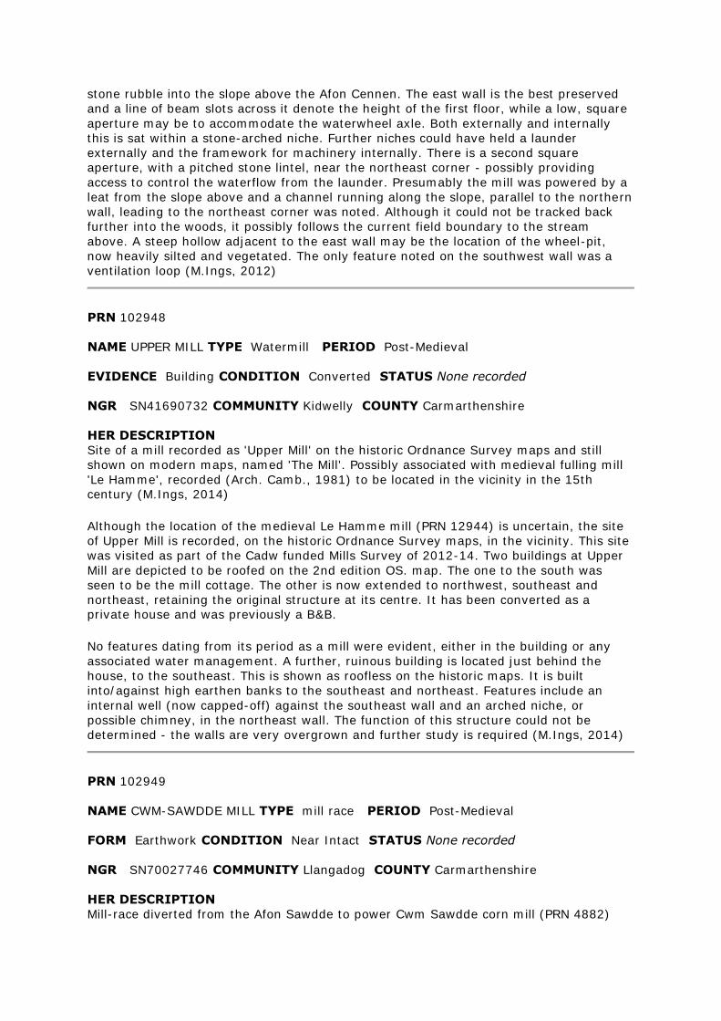
stone rubble into the slope above the Afon Cennen. The east wall is the best preserved
and a line of beam slots across it denote the height of the first floor, while a low, square
aperture may be to accommodate the waterwheel axle. Both externally and internally
this is sat within a stone-arched niche. Further niches could have held a launder
externally and the framework for machinery internally. There is a second square
aperture, with a pitched stone lintel, near the northeast corner - possibly providing
access to control the waterflow from the launder. Presumably the mill was powered by a
leat from the slope above and a channel running along the slope, parallel to the northern
wall, leading to the northeast corner was noted. Although it could not be tracked back
further into the woods, it possibly follows the current field boundary to the stream
above. A steep hollow adjacent to the east wall may be the location of the wheel-pit,
now heavily silted and vegetated. The only feature noted on the southwest wall was a
ventilation loop (M.Ings, 2012)
PRN 102948
NAME UPPER MILL TYPE Watermill PERIOD Post-Medieval
EVIDENCE Building CONDITION Converted STATUS None recorded
NGR SN41690732 COMMUNITY Kidwelly COUNTY Carmarthenshire
HER DESCRIPTION
Site of a mill recorded as 'Upper Mill' on the historic Ordnance Survey maps and still
shown on modern maps, named 'The Mill'. Possibly associated with medieval fulling mill
'Le Hamme', recorded (Arch. Camb., 1981) to be located in the vicinity in the 15th century (M.Ings, 2014)
Although the location of the medieval Le Hamme mill (PRN 12944) is uncertain, the site
of Upper Mill is recorded, on the historic Ordnance Survey maps, in the vicinity. This site
was visited as part of the Cadw funded Mills Survey of 2012-14. Two buildings at Upper
Mill are depicted to be roofed on the 2nd edition OS. map. The one to the south was
seen to be the mill cottage. The other is now extended to northwest, southeast and
northeast, retaining the original structure at its centre. It has been converted as a private house and was previously a B&B.
No features dating from its period as a mill were evident, either in the building or any
associated water management. A further, ruinous building is located just behind the
house, to the southeast. This is shown as roofless on the historic maps. It is built
into/against high earthen banks to the southeast and northeast. Features include an
internal well (now capped-off) against the southeast wall and an arched niche, or
possible chimney, in the northeast wall. The function of this structure could not be
determined - the walls are very overgrown and further study is required (M.Ings, 2014)
PRN 102949
NAME CWM-SAWDDE MILL TYPE mill race PERIOD Post-Medieval
FORM Earthwork CONDITION Near Intact STATUS None recorded
NGR SN70027746 COMMUNITY Llangadog COUNTY Carmarthenshire
HER DESCRIPTION
Mill-race diverted from the Afon Sawdde to power Cwm Sawdde corn mill (PRN 4882)
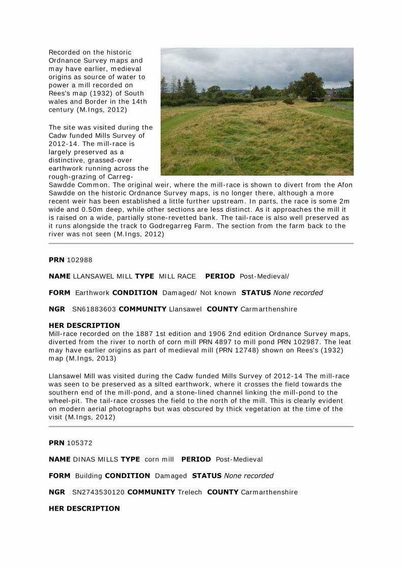
Recorded on the historic
Ordnance Survey maps and
may have earlier, medieval
origins as source of water to
power a mill recorded on
Rees's map (1932) of South
wales and Border in the 14th century (M.Ings, 2012)
The site was visited during the
Cadw funded Mills Survey of
2012-14. The mill-race is
largely preserved as a
distinctive, grassed-over
earthwork running across the
rough-grazing of Carreg-
Sawdde Common. The original weir, where the mill-race is shown to divert from the Afon
Sawdde on the historic Ordnance Survey maps, is no longer there, although a more
recent weir has been established a little further upstream. In parts, the race is some 2m
wide and 0.50m deep, while other sections are less distinct. As it approaches the mill it
is raised on a wide, partially stone-revetted bank. The tail-race is also well preserved as
it runs alongside the track to Godregarreg Farm. The section from the farm back to the
river was not seen (M.Ings, 2012)
PRN 102988
NAME LLANSAWEL MILL TYPE MILL RACE PERIOD Post-Medieval/
FORM Earthwork CONDITION Damaged/ Not known STATUS None recorded
NGR SN61883603 COMMUNITY Llansawel COUNTY Carmarthenshire
HER DESCRIPTION
Mill-race recorded on the 1887 1st edition and 1906 2nd edition Ordnance Survey maps,
diverted from the river to north of corn mill PRN 4897 to mill pond PRN 102987. The leat
may have earlier origins as part of medieval mill (PRN 12748) shown on Rees's (1932) map (M.Ings, 2013)
Llansawel Mill was visited during the Cadw funded Mills Survey of 2012-14 The mill-race
was seen to be preserved as a silted earthwork, where it crosses the field towards the
southern end of the mill-pond, and a stone-lined channel linking the mill-pond to the
wheel-pit. The tail-race crosses the field to the north of the mill. This is clearly evident
on modern aerial photographs but was obscured by thick vegetation at the time of the
visit (M.Ings, 2012)
PRN 105372
NAME DINAS MILLS TYPE corn mill PERIOD Post-Medieval
FORM Building CONDITION Damaged STATUS None recorded
NGR SN2743530120 COMMUNITY Trelech COUNTY Carmarthenshire
HER DESCRIPTION
Corn mill recorded on the historic Ordnance Survey maps, powered by a mill-race
diverted from the Afon Cynon to the northeast. Saw mill (PRN 7815) was built in c.1919
just to the north and was powered by the same race, which bifurcates to feed individual
overshot wheels (M.Ings, 2013)
The mill was seen as part of the Cadw funded Mills Survey of 2012-14. The site is now
roofless and ruinous with the facade now partially collapsed, although a wooden-framed
window aperture was still preserved. The interior was inaccessible due to heavy
undergrowth. The wheel-pit alongside the north-facing side wall was seen but the
overshot wheel has now gone. Access to the mill-race was not possible as it runs across
a neighbour's land and the owner was away (M.Ings, 2013)
PRN 105374
NAME GARREGLEFAIN TYPE corn mill PERIOD Post-Medieval
FORM Earthwork CONDITION Near Destroyed STATUS None recorded
NGR SN71863670 COMMUNITY Cilycwm COUNTY Carmarthenshire
HER DESCRIPTION
Possible site of former mill located within wooded stream valley to the north of Allt
Carreglefain. Not recorded on the historic or modern maps (M.Ings, 2013)
A local resident showed me the site of this possible mill during the Cadw funded Mills
Survey of 2012-14. No structural remains of the mill appear to survive and the only
visible indications of a possible mill site were a mill stone and a short stretch of leat
diverted from the stream. Undergrowth was thick so other features may have been
obscured. A trackway leading through the woods past the site was also noted (M.Ings,
2013)
PRN 105377
NAME FFYNNON-DDRAIN MILL TYPE mill race PERIOD Post-Medieval
FORM Earthwork CONDITION Damaged STATUS None recorded
NGR SN40302184 COMMUNITY Carmarthen COUNTY Carmarthenshire
HER DESCRIPTION
Mill-race recorded on the historic Ordnance Survey maps, diverted from river to power
Ffynnon-Ddrain corn mill (PRN 199) (M.Ings, 2013)
The site was seen during the Cadw funded Mills Survey of 2012-14. The mill-race
survives as a distinct earthwork where it passes through scrub woodland, following the
contour of the hill-slope above the river. The ditch is a metre wide and some 0.60
metres deep, although heavily silted, with a wide outer bank. The section across pasture
fields to the river could not be traced, presumed infilled, and the last section closest to
the mill was largely inaccessible due to heavy vegetation (M.Ings, 2013)
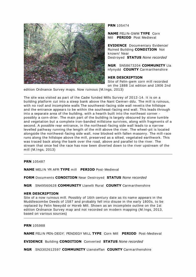
PRN 105474
NAME FELIN-GWM TYPE Corn
Mill PERIOD Post Medieval
EVIDENCE Documentary Evidence/
Ruined Building CONDITION Not
known/ Near
Destroyed STATUS None recorded
NGR SN58673204 COMMUNITY Lla
nfynydd COUNTY Carmarthenshire
HER DESCRIPTION
Site of Felin-gwm corn mill recorded
on the 1888 1st edition and 1906 2nd
edition Ordnance Survey maps. Now ruinous (M.Ings, 2013)
The site was visited as part of the Cadw funded Mills Survey of 2012-14. It is on a
building platform cut into a steep bank above the Nant Cwmwr-ddu. The mill is ruinous,
with no roof and incomplete walls The southwest-facing side wall revetts the hillslope
and the entrance appears to be within the southeast-facing end wall. This leads through
into a separate area of the building, with a hearth built into the northeast corner -
possibly a corn-drier. The main part of the building is largely obscured by stone tumble
and vegetation but a complete iron-banded millstone survives, along with fragments of a
second. A possible rear entrance, in the northeast-facing side wall leads to a narrow
levelled pathway running the length of the mill above the river. The wheel-pit is located
alongside the northwest-facing side wall, now blocked with fallen masonry. The mill-race
runs along the hillslope above the mill, preserved as a silted, vegetated earthwork. This
was traced back along the bank over the road, above and parallel to the river. The
stream that once fed the race has now been diverted down to the river upstream of the
mill (M.Ings, 2013)
PRN 105487
NAME MELIN YR AFR TYPE mill PERIOD Post-Medieval
FORM Documents CONDITION Near Destroyed STATUS None recorded
NGR SN49560628 COMMUNITY Llanelli Rural COUNTY Carmarthenshire
HER DESCRIPTION
Site of a now ruinous mill. Possibly of 16th century date as its name appears in the
Muddlescombe Deeds of 1587 and probably fell into disuse in the early 1800s, to be
replaced by Felin Newydd or Horeb Mill. Shown as an incomplete outline on the 1st
edition Ordnance Survey map and not recorded on modern mapping (M.Ings, 2013,
based on various sources)
PRN 105988
NAME FELIN PEN-DEGY; PENDEGY MILL TYPE Corn Mill PERIOD Post-Medieval
EVIDENCE Building CONDITION Converted STATUS None recorded
NGR SN3302612597 COMMUNITY Llansteffan COUNTY Carmarthenshire

HER DESCRIPTION
Site of a corn mill recorded on the historic Ordnance Survey maps, to the west of
Llanybri, and still shown on modern maps. It is possibly associated with an earlier,
medieval watermill (PRN 12644) recorded on Rees' (1932) map of South Wales & Border
in the 14th century (M.Ings, 2014)
The site was visited as part of the Cadw funded Mills Survey of 2012-14. The mill
building is intact, restored and possibly converted. Unfortunately the owners were away
at the time of the visit so the interior could not be seen.It is a gable-ended building that
adjoins, and is slightly higher than, a second building to the north. A low, arched window
in the south-facing gable may originally been the axle aperture for the waterwheel,
although the wheel-pit has now been infilled. The mill race survives to the south and
east of the mill (M.Ings, 2014)

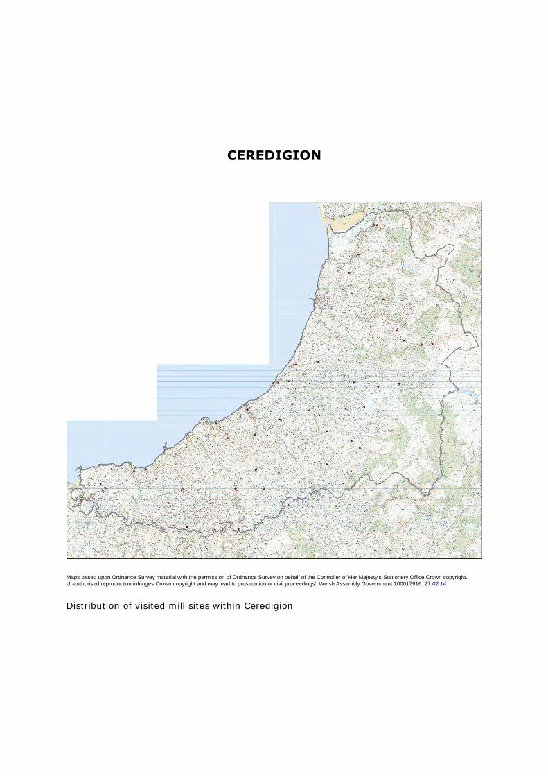
CEREDIGION
Maps based upon Ordnance Survey material with the permission of Ordnance Survey on behalf of the Controller of Her Majesty's Stationery Office Crown copyright. Unauthorised reproduction infringes Crown copyright and may lead to prosecution or civil proceedings'. Welsh Assembly Government 100017916. 27.02.14
Distribution of visited mill sites within Ceredigion
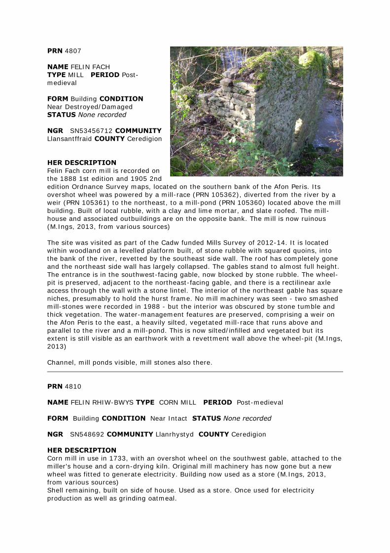
PRN 4807
NAME FELIN FACH
TYPE MILL PERIOD Post-
medieval
FORM Building CONDITION
Near Destroyed/Damaged
STATUS None recorded
NGR SN53456712 COMMUNITY
Llansantffraid COUNTY Ceredigion
HER DESCRIPTION
Felin Fach corn mill is recorded on
the 1888 1st edition and 1905 2nd
edition Ordnance Survey maps, located on the southern bank of the Afon Peris. Its
overshot wheel was powered by a mill-race (PRN 105362), diverted from the river by a
weir (PRN 105361) to the northeast, to a mill-pond (PRN 105360) located above the mill
building. Built of local rubble, with a clay and lime mortar, and slate roofed. The mill-
house and associated outbuildings are on the opposite bank. The mill is now ruinous
(M.Ings, 2013, from various sources)
The site was visited as part of the Cadw funded Mills Survey of 2012-14. It is located
within woodland on a levelled platform built, of stone rubble with squared quoins, into
the bank of the river, revetted by the southeast side wall. The roof has completely gone
and the northeast side wall has largely collapsed. The gables stand to almost full height.
The entrance is in the southwest-facing gable, now blocked by stone rubble. The wheel-
pit is preserved, adjacent to the northeast-facing gable, and there is a rectilinear axle
access through the wall with a stone lintel. The interior of the northeast gable has square
niches, presumably to hold the hurst frame. No mill machinery was seen - two smashed
mill-stones were recorded in 1988 - but the interior was obscured by stone tumble and
thick vegetation. The water-management features are preserved, comprising a weir on
the Afon Peris to the east, a heavily silted, vegetated mill-race that runs above and
parallel to the river and a mill-pond. This is now silted/infilled and vegetated but its
extent is still visible as an earthwork with a revettment wall above the wheel-pit (M.Ings,
2013)
Channel, mill ponds visible, mill stones also there.
PRN 4810
NAME FELIN RHIW-BWYS TYPE CORN MILL PERIOD Post-medieval
FORM Building CONDITION Near Intact STATUS None recorded
NGR SN548692 COMMUNITY Llanrhystyd COUNTY Ceredigion
HER DESCRIPTION
Corn mill in use in 1733, with an overshot wheel on the southwest gable, attached to the
miller's house and a corn-drying kiln. Original mill machinery has now gone but a new
wheel was fitted to generate electricity. Building now used as a store (M.Ings, 2013,
from various sources)
Shell remaining, built on side of house. Used as a store. Once used for electricity
production as well as grinding oatmeal.
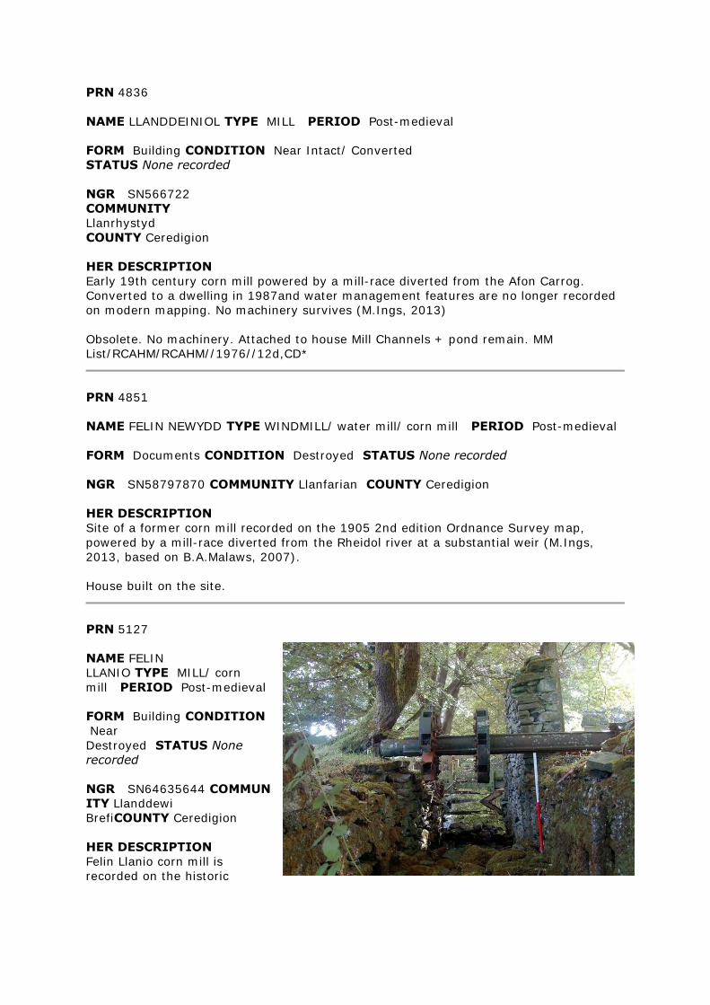
PRN 4836
NAME LLANDDEINIOL TYPE MILL PERIOD Post-medieval
FORM Building CONDITION Near Intact/ Converted
STATUS None recorded
NGR SN566722
COMMUNITY
Llanrhystyd
COUNTY Ceredigion
HER DESCRIPTION
Early 19th century corn mill powered by a mill-race diverted from the Afon Carrog.
Converted to a dwelling in 1987and water management features are no longer recorded
on modern mapping. No machinery survives (M.Ings, 2013)
Obsolete. No machinery. Attached to house Mill Channels + pond remain. MM
List/RCAHM/RCAHM//1976//12d,CD*
PRN 4851
NAME FELIN NEWYDD TYPE WINDMILL/ water mill/ corn mill PERIOD Post-medieval
FORM Documents CONDITION Destroyed STATUS None recorded
NGR SN58797870 COMMUNITY Llanfarian COUNTY Ceredigion
HER DESCRIPTION
Site of a former corn mill recorded on the 1905 2nd edition Ordnance Survey map,
powered by a mill-race diverted from the Rheidol river at a substantial weir (M.Ings,
2013, based on B.A.Malaws, 2007).
House built on the site.
PRN 5127
NAME FELIN
LLANIO TYPE MILL/ corn
mill PERIOD Post-medieval
FORM Building CONDITION
Near
Destroyed STATUS None
recorded
NGR SN64635644 COMMUN
ITY Llanddewi
BrefiCOUNTY Ceredigion
HER DESCRIPTION
Felin Llanio corn mill is
recorded on the historic
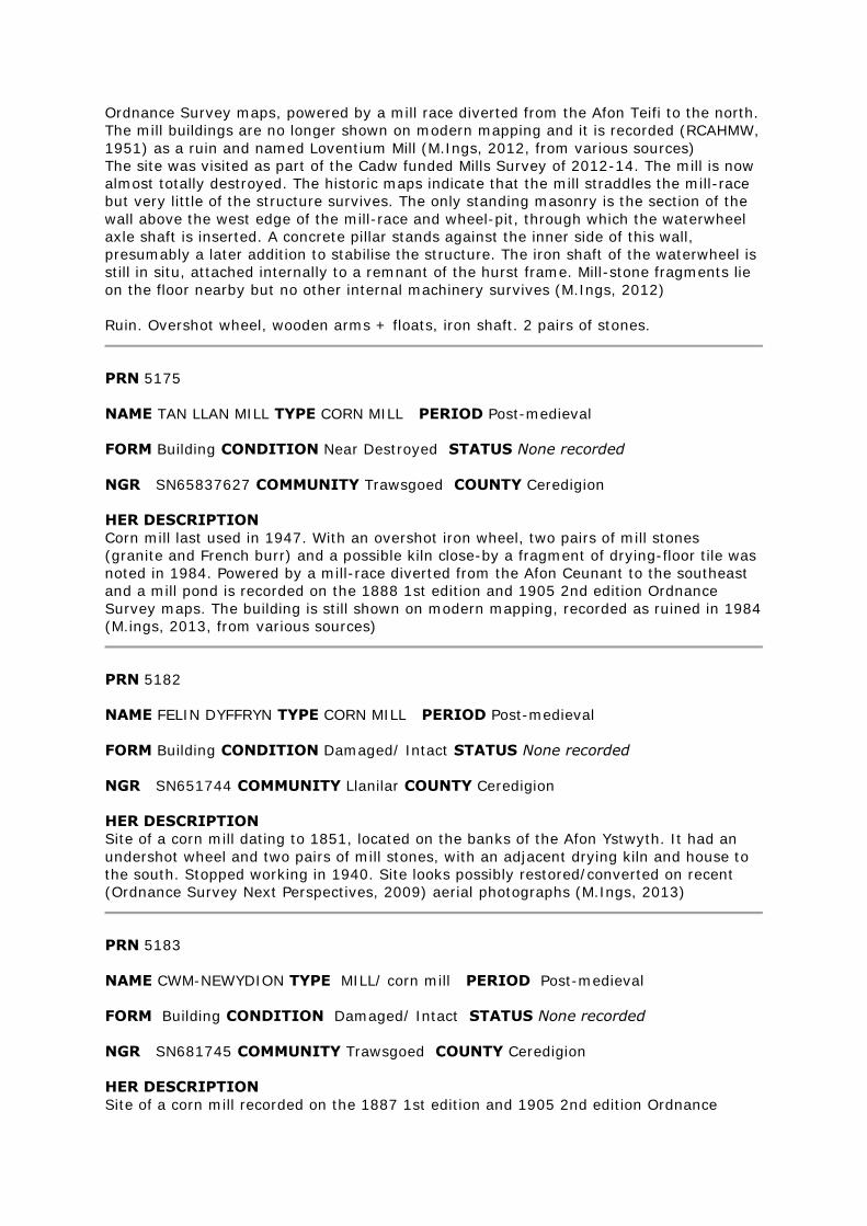
Ordnance Survey maps, powered by a mill race diverted from the Afon Teifi to the north.
The mill buildings are no longer shown on modern mapping and it is recorded (RCAHMW,
1951) as a ruin and named Loventium Mill (M.Ings, 2012, from various sources)
The site was visited as part of the Cadw funded Mills Survey of 2012-14. The mill is now
almost totally destroyed. The historic maps indicate that the mill straddles the mill-race
but very little of the structure survives. The only standing masonry is the section of the
wall above the west edge of the mill-race and wheel-pit, through which the waterwheel
axle shaft is inserted. A concrete pillar stands against the inner side of this wall,
presumably a later addition to stabilise the structure. The iron shaft of the waterwheel is
still in situ, attached internally to a remnant of the hurst frame. Mill-stone fragments lie
on the floor nearby but no other internal machinery survives (M.Ings, 2012)
Ruin. Overshot wheel, wooden arms + floats, iron shaft. 2 pairs of stones.
PRN 5175
NAME TAN LLAN MILL TYPE CORN MILL PERIOD Post-medieval
FORM Building CONDITION Near Destroyed STATUS None recorded
NGR SN65837627 COMMUNITY Trawsgoed COUNTY Ceredigion
HER DESCRIPTION
Corn mill last used in 1947. With an overshot iron wheel, two pairs of mill stones
(granite and French burr) and a possible kiln close-by a fragment of drying-floor tile was
noted in 1984. Powered by a mill-race diverted from the Afon Ceunant to the southeast
and a mill pond is recorded on the 1888 1st edition and 1905 2nd edition Ordnance
Survey maps. The building is still shown on modern mapping, recorded as ruined in 1984
(M.ings, 2013, from various sources)
PRN 5182
NAME FELIN DYFFRYN TYPE CORN MILL PERIOD Post-medieval
FORM Building CONDITION Damaged/ Intact STATUS None recorded
NGR SN651744 COMMUNITY Llanilar COUNTY Ceredigion
HER DESCRIPTION
Site of a corn mill dating to 1851, located on the banks of the Afon Ystwyth. It had an
undershot wheel and two pairs of mill stones, with an adjacent drying kiln and house to
the south. Stopped working in 1940. Site looks possibly restored/converted on recent
(Ordnance Survey Next Perspectives, 2009) aerial photographs (M.Ings, 2013)
PRN 5183
NAME CWM-NEWYDION TYPE MILL/ corn mill PERIOD Post-medieval
FORM Building CONDITION Damaged/ Intact STATUS None recorded
NGR SN681745 COMMUNITY Trawsgoed COUNTY Ceredigion
HER DESCRIPTION
Site of a corn mill recorded on the 1887 1st edition and 1905 2nd edition Ordnance
Survey maps, powered by a mill-race and mill-pond (PRN 38274) The building is still
shown on modern mapping and recent aerial photographs (Ordnance Survey Next
Perspectives, 2009)- possibly restored/converted and the race and pond are not shown
(M.Ings, 2013)
A former water mill that was being used as a store when recorded by the Royal
Commission in 1976. Its machinery had been removed by that time.
PRN 5187
NAME FELIN GYFFIN TYPE CORN MILL PERIOD Post-medieval
FORM Building CONDITION Near Intact/ Restored STATUS None recorded
NGR SN642864 COMMUNITY Tirymynach COUNTY Ceredigion
HER DESCRIPTION
Felin Gyffin corn mill is recorded on the historic Ordnance Survey maps, powered by a
mill-race diverted off the river to the southeast. It was recorded in 2011 that most of its
19th century machinery, including two pairs of stones, is retained and that a hurst beam
with a 1714 date indicates an earlier mill on the site (M.Ings, 2013, from various
sources)
The site was visited as part of the Cadw funded Mills Project of 2012-14. The current
owner told me that the internal 19th century machinery was preserved but had been
boarded up as protection from vermin. The wheel-pit, alongside the south-facing gable,
is preserved and complete with a working, restored overshot wheel. The iron-frame and
hub were cast at the Rheidol Foundry, Aberystwyth and new wooden paddles and a
launder have been fashioned. The facade, incorporating the doorway and two windows,
is whitewashed. The owner said that the side walls had been taken down and rebuilt by a
former owner, although he believed the gable end to be original. He was unaware of an
earlier mill on the site. The mill-race, which originates on a neighbouring property, is
preserved although damaged by rabbit activity. The water supply to the wheel is now
piped (M.Ings, 2013)
There is evidence of an earlier mill of 1714. This mill was very much in use until 1973, it
is a most unusual survivor to date unique in Cardiganshire.
PRN 5192
NAME PEN-Y-BONTBREN TYPE CORN MILL PERIOD Post-medieval
FORM Building CONDITION Damaged/ Converted STATUS None recorded
NGR SN65788963 COMMUNITY Ceulanamaesmawr COUNTY Ceredigion
HER DESCRIPTION
Site of a corn mill recorded n the historic Ordnance Survey maps, located on the
northeast edge of Talybont. It appears to have been powered by a leat diverting water
from the Afon Ceulan, to the northeast, with a possible holding pond located to the east
of the mill. The building is still shown on modern mapping (M.Ings, 2013)
The site was visited as part of the Cadw funded Mills Survey of 2012-14. The historic
Ordnance Survey maps depict two adjoining buildings, possibly the mill and the mill
house - both have now been converted for domestic use but, as the owners were away,
it is not known what, if any, internal features survive. Two pairs of stones were recorded
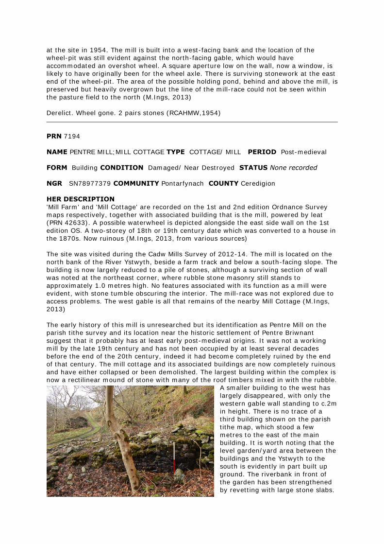
at the site in 1954. The mill is built into a west-facing bank and the location of the
wheel-pit was still evident against the north-facing gable, which would have
accommodated an overshot wheel. A square aperture low on the wall, now a window, is
likely to have originally been for the wheel axle. There is surviving stonework at the east
end of the wheel-pit. The area of the possible holding pond, behind and above the mill, is
preserved but heavily overgrown but the line of the mill-race could not be seen within
the pasture field to the north (M.Ings, 2013)
Derelict. Wheel gone. 2 pairs stones (RCAHMW,1954)
PRN 7194
NAME PENTRE MILL;MILL COTTAGE TYPE COTTAGE/ MILL PERIOD Post-medieval
FORM Building CONDITION Damaged/ Near Destroyed STATUS None recorded
NGR SN78977379 COMMUNITY Pontarfynach COUNTY Ceredigion
HER DESCRIPTION
'Mill Farm' and 'Mill Cottage' are recorded on the 1st and 2nd edition Ordnance Survey
maps respectively, together with associated building that is the mill, powered by leat
(PRN 42633). A possible waterwheel is depicted alongside the east side wall on the 1st
edition OS. A two-storey of 18th or 19th century date which was converted to a house in
the 1870s. Now ruinous (M.Ings, 2013, from various sources)
The site was visited during the Cadw Mills Survey of 2012-14. The mill is located on the
north bank of the River Ystwyth, beside a farm track and below a south-facing slope. The
building is now largely reduced to a pile of stones, although a surviving section of wall
was noted at the northeast corner, where rubble stone masonry still stands to
approximately 1.0 metres high. No features associated with its function as a mill were
evident, with stone tumble obscuring the interior. The mill-race was not explored due to
access problems. The west gable is all that remains of the nearby Mill Cottage (M.Ings,
2013)
The early history of this mill is unresearched but its identification as Pentre Mill on the
parish tithe survey and its location near the historic settlement of Pentre Briwnant
suggest that it probably has at least early post-medieval origins. It was not a working
mill by the late 19th century and has not been occupied by at least several decades
before the end of the 20th century, indeed it had become completely ruined by the end
of that century. The mill cottage and its associated buildings are now completely ruinous
and have either collapsed or been demolished. The largest building within the complex is
now a rectilinear mound of stone with many of the roof timbers mixed in with the rubble.
A smaller building to the west has
largely disappeared, with only the
western gable wall standing to c.2m
in height. There is no trace of a
third building shown on the parish
tithe map, which stood a few
metres to the east of the main
building. It is worth noting that the
level garden/yard area between the
buildings and the Ystwyth to the
south is evidently in part built up
ground. The riverbank in front of
the garden has been strengthened
by revetting with large stone slabs.
It is also clear that there was a subterranean tailrace running from the now infilled
wheel-pit across to the riverbank. A substantial earthwork leat, which is actually stone
cut for the first 50m or so of its course, taps into the Ystwyth about 300m upstream. The
leat is cut by late 19th century mining features, indicating that the mill was defunct by
that time. C18th-C19th. Derelict. 2-storey, stone, inglenook fireplace.
PRN 8210
NAME PANDY;RHUDDLAN TEIFI;RHUDLLAN DEIFI TYPE FULLING
MILL PERIOD Medieval
FORM Documents CONDITION Not known STATUS None recorded
NGR SN494432 COMMUNITY Llanwenog COUNTY Ceredigion
HER DESCRIPTION
Site of a fulling mill recorded on Rees's map (1932) of South Wales & Border in the 14th
century. Not shown on historic or modern mapping, location uncertain (M.Ings, 2013)
PRN 8680
NAME FELIN ISAF TYPE CORN MILL PERIOD Post-medieval
FORM Building CONDITION Near Intact STATUS None recorded
NGR SN31685398 COMMUNITY Llangrannog COUNTY Ceredigion
HER DESCRIPTION
A small corn mill of possible 18th century date recorded on the 1889 1st edition and
1905 2nd edition Ordnance Survey maps. An overshot wheel was powered by a leat from
a weir across the Nant Hawen and a mill-pond above the mill to the south. The building
is still shown on modern mapping and the machinery was recorded as being intact in
2004. The pond and leat are not shown on modern mapping (M.Ings, 2013)
Corn mill, also called Llangranog Mill and known as Felin Isaf to distinguish it from Felin
Uchaf 1km to the east (PRN 43537). Apparently post-medieval - not shown on Rees'
map of 14th century South Wales. Not observed Sept 2001
PRN 8717
NAME FELIN TYGLYN TYPE CORN MILL PERIOD Post-medieval
FORM Building CONDITION Damaged/ Converted STATUS None recorded
NGR SN50015950 COMMUNITY Ciliau Aeron COUNTY Ceredigion
HER DESCRIPTION
The site of an 18th century corn mill recorded on the historic Ordnance Survey maps and
still shown on modern mapping. It is built of rubble masonry with squared quoins and
with timber lintels to most openings. The mill was powered by an internal breast-shot
wheel, driving two pairs of mill stones. Last used around 1920. A corn-drying kiln is
attached to the house. Recorded as ruinous in 1983, it was restored and converted to a
garage and studio in the 1990s (M.Ings, 2013, from various sources)
Maes-y-felin in close proximity
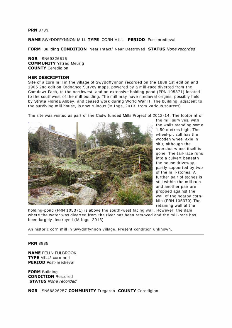
PRN 8733
NAME SWYDDFFYNNON MILL TYPE CORN MILL PERIOD Post-medieval
FORM Building CONDITION Near Intact/ Near Destroyed STATUS None recorded
NGR SN69326616
COMMUNITY Ystrad Meurig
COUNTY Ceredigion
HER DESCRIPTION
Site of a corn mill in the village of Swyddffynnon recorded on the 1889 1st edition and
1905 2nd edition Ordnance Survey maps, powered by a mill-race diverted from the
Camddwr Fach, to the northwest, and an extensive holding pond (PRN 105371) located
to the southwest of the mill building. The mill may have medieval origins, possibly held
by Strata Florida Abbey, and ceased work during World War II. The building, adjacent to
the surviving mill house, is now ruinous (M.Ings, 2013, from various sources)
The site was visited as part of the Cadw funded Mills Project of 2012-14. The footprint of
the mill survives, with
the walls standing some
1.50 metres high. The
wheel-pit still has the
wooden wheel axle in
situ, although the
overshot wheel itself is
gone. The tail-race runs
into a culvert beneath
the house driveway,
partly supported by two
of the mill-stones. A
further pair of stones is
still within the mill ruin
and another pair are
propped against the
wall of the nearby corn-
kiln (PRN 105370) The
retaining wall of the
holding-pond (PRN 105371) is above the south-west facing wall. However, the dam
where the water was diverted from the river has been removed and the mill-race has
been largely destroyed (M.Ings, 2013)
An historic corn mill in Swyddffynnon village. Present condition unknown.
PRN 8985
NAME FELIN FULBROOK
TYPE MILL/ corn mill
PERIOD Post-medieval
FORM Building
CONDITION Restored
STATUS None recorded
NGR SN66826257 COMMUNITY Tregaron COUNTY Ceredigion
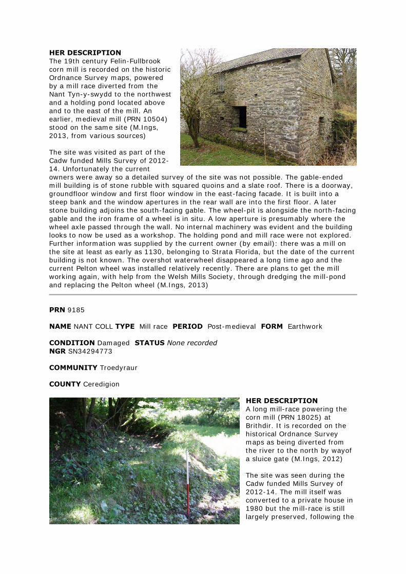
HER DESCRIPTION
The 19th century Felin-Fullbrook
corn mill is recorded on the historic
Ordnance Survey maps, powered
by a mill race diverted from the
Nant Tyn-y-swydd to the northwest
and a holding pond located above
and to the east of the mill. An
earlier, medieval mill (PRN 10504)
stood on the same site (M.Ings,
2013, from various sources)
The site was visited as part of the
Cadw funded Mills Survey of 2012-
14. Unfortunately the current
owners were away so a detailed survey of the site was not possible. The gable-ended
mill building is of stone rubble with squared quoins and a slate roof. There is a doorway,
groundfloor window and first floor window in the east-facing facade. It is built into a
steep bank and the window apertures in the rear wall are into the first floor. A later
stone building adjoins the south-facing gable. The wheel-pit is alongside the north-facing
gable and the iron frame of a wheel is in situ. A low aperture is presumably where the
wheel axle passed through the wall. No internal machinery was evident and the building
looks to now be used as a workshop. The holding pond and mill race were not explored.
Further information was supplied by the current owner (by email): there was a mill on
the site at least as early as 1130, belonging to Strata Florida, but the date of the current
building is not known. The overshot waterwheel disappeared a long time ago and the
current Pelton wheel was installed relatively recently. There are plans to get the mill
working again, with help from the Welsh Mills Society, through dredging the mill-pond
and replacing the Pelton wheel (M.Ings, 2013)
PRN 9185
NAME NANT COLL TYPE Mill race PERIOD Post-medieval FORM Earthwork
CONDITION Damaged STATUS None recorded
NGR SN34294773
COMMUNITY Troedyraur
COUNTY Ceredigion
HER DESCRIPTION
A long mill-race powering the
corn mill (PRN 18025) at
Brithdir. It is recorded on the
historical Ordnance Survey
maps as being diverted from
the river to the north by wayof
a sluice gate (M.Ings, 2012)
The site was seen during the
Cadw funded Mills Survey of
2012-14. The mill itself was
converted to a private house in
1980 but the mill-race is still
largely preserved, following the
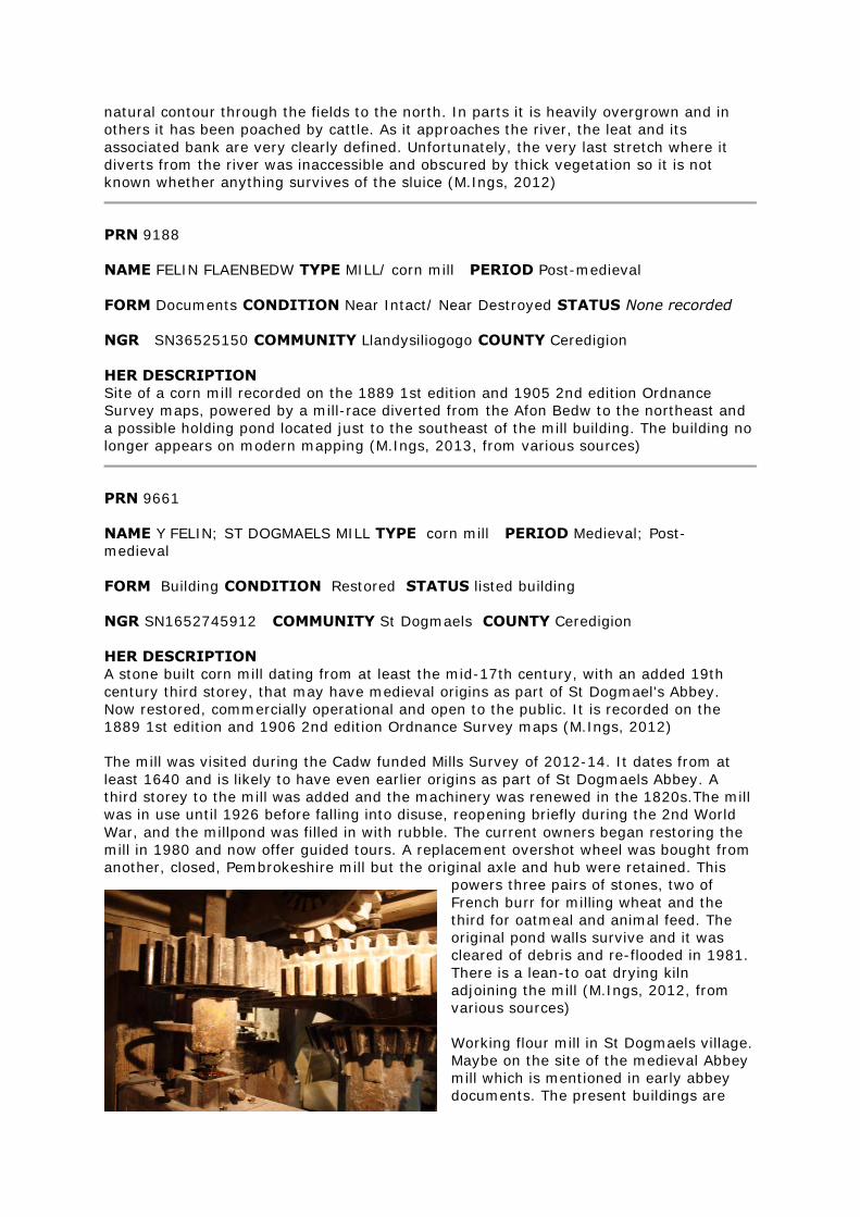
natural contour through the fields to the north. In parts it is heavily overgrown and in
others it has been poached by cattle. As it approaches the river, the leat and its
associated bank are very clearly defined. Unfortunately, the very last stretch where it
diverts from the river was inaccessible and obscured by thick vegetation so it is not
known whether anything survives of the sluice (M.Ings, 2012)
PRN 9188
NAME FELIN FLAENBEDW TYPE MILL/ corn mill PERIOD Post-medieval
FORM Documents CONDITION Near Intact/ Near Destroyed STATUS None recorded
NGR SN36525150 COMMUNITY Llandysiliogogo COUNTY Ceredigion
HER DESCRIPTION
Site of a corn mill recorded on the 1889 1st edition and 1905 2nd edition Ordnance
Survey maps, powered by a mill-race diverted from the Afon Bedw to the northeast and
a possible holding pond located just to the southeast of the mill building. The building no
longer appears on modern mapping (M.Ings, 2013, from various sources)
PRN 9661
NAME Y FELIN; ST DOGMAELS MILL TYPE corn mill PERIOD Medieval; Post-
medieval
FORM Building CONDITION Restored STATUS listed building
NGR SN1652745912 COMMUNITY St Dogmaels COUNTY Ceredigion
HER DESCRIPTION
A stone built corn mill dating from at least the mid-17th century, with an added 19th
century third storey, that may have medieval origins as part of St Dogmael's Abbey.
Now restored, commercially operational and open to the public. It is recorded on the
1889 1st edition and 1906 2nd edition Ordnance Survey maps (M.Ings, 2012)
The mill was visited during the Cadw funded Mills Survey of 2012-14. It dates from at
least 1640 and is likely to have even earlier origins as part of St Dogmaels Abbey. A
third storey to the mill was added and the machinery was renewed in the 1820s.The mill
was in use until 1926 before falling into disuse, reopening briefly during the 2nd World
War, and the millpond was filled in with rubble. The current owners began restoring the
mill in 1980 and now offer guided tours. A replacement overshot wheel was bought from
another, closed, Pembrokeshire mill but the original axle and hub were retained. This
powers three pairs of stones, two of
French burr for milling wheat and the
third for oatmeal and animal feed. The
original pond walls survive and it was
cleared of debris and re-flooded in 1981.
There is a lean-to oat drying kiln
adjoining the mill (M.Ings, 2012, from
various sources)
Working flour mill in St Dogmaels village.
Maybe on the site of the medieval Abbey
mill which is mentioned in early abbey
documents. The present buildings are
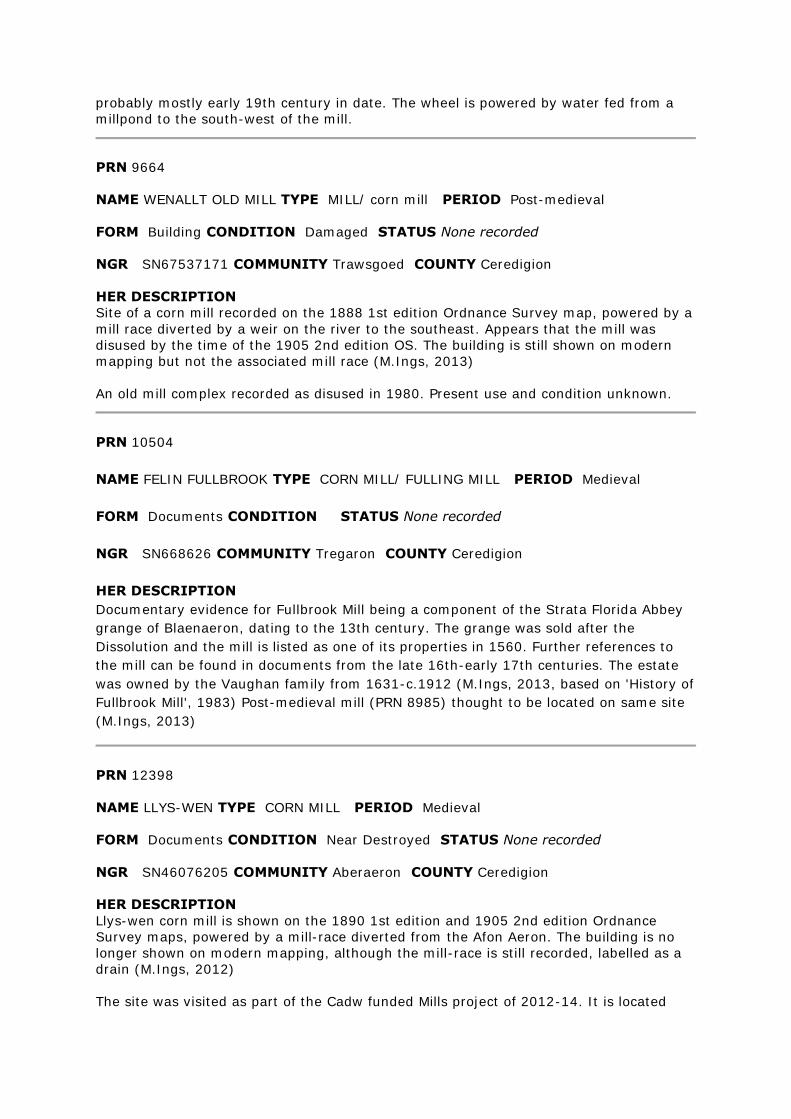
probably mostly early 19th century in date. The wheel is powered by water fed from a
millpond to the south-west of the mill.
PRN 9664
NAME WENALLT OLD MILL TYPE MILL/ corn mill PERIOD Post-medieval
FORM Building CONDITION Damaged STATUS None recorded
NGR SN67537171 COMMUNITY Trawsgoed COUNTY Ceredigion
HER DESCRIPTION
Site of a corn mill recorded on the 1888 1st edition Ordnance Survey map, powered by a
mill race diverted by a weir on the river to the southeast. Appears that the mill was
disused by the time of the 1905 2nd edition OS. The building is still shown on modern
mapping but not the associated mill race (M.Ings, 2013)
An old mill complex recorded as disused in 1980. Present use and condition unknown.
PRN 10504
NAME FELIN FULLBROOK TYPE CORN MILL/ FULLING MILL PERIOD Medieval
FORM Documents CONDITION STATUS None recorded
NGR SN668626 COMMUNITY Tregaron COUNTY Ceredigion
HER DESCRIPTION
Documentary evidence for Fullbrook Mill being a component of the Strata Florida Abbey
grange of Blaenaeron, dating to the 13th century. The grange was sold after the
Dissolution and the mill is listed as one of its properties in 1560. Further references to
the mill can be found in documents from the late 16th-early 17th centuries. The estate
was owned by the Vaughan family from 1631-c.1912 (M.Ings, 2013, based on 'History of
Fullbrook Mill', 1983) Post-medieval mill (PRN 8985) thought to be located on same site
(M.Ings, 2013)
PRN 12398
NAME LLYS-WEN TYPE CORN MILL PERIOD Medieval
FORM Documents CONDITION Near Destroyed STATUS None recorded
NGR SN46076205 COMMUNITY Aberaeron COUNTY Ceredigion
HER DESCRIPTION
Llys-wen corn mill is shown on the 1890 1st edition and 1905 2nd edition Ordnance
Survey maps, powered by a mill-race diverted from the Afon Aeron. The building is no
longer shown on modern mapping, although the mill-race is still recorded, labelled as a
drain (M.Ings, 2012)
The site was visited as part of the Cadw funded Mills project of 2012-14. It is located
within woodland by the side of a public footpath. The building is now very ruinous and
collapsed masonry obscures much of the site. It appears to have been an 'L'-shaped
structure, with the millrace running alongside its eastern wall and a possible entrance in
the south wall. A remnant of an internal wall was noted but no other features were
evident. A later building, constructed largely of timber and corrugated-iron, adjoins the
north wall and an access has been inserted between the two. The wheel, now gone, was
presumably undershot as there is no indication of a wheel-pit (M.Ings, 2012)
PRN 12691
NAME PANTOLWEN TYPE Water Mill PERIOD Medieval
EVIDENCE Documentary Evidence CONDITION Near Destroyed STATUS None
recorded
NGR SN417419 COMMUNITY Llandysul COUNTY Ceredigion
HER DESCRIPTION
Site of a mill shown on Rees's map (1932) showing Wales in the 14th century. The site is
now occupied by post-medieval Pantolwen Mills (PRN 16686) (M.Ings, 2012)
PRN 12955
NAME MEFENYDD;MELYN IRRYD VENDIGID TYPE CORN MILL/ FULLING
MILL PERIOD Medieval
FORM Documents CONDITION Near Destroyed STATUS None recorded
NGR SN7315566555 COMMUNITY Ystrad Fflur COUNTY Ceredigion
HER DESCRIPTION
A medieval corn mill, possibly the site of the former Strata Florida mill for the Grange of
Mefenydd - 'Rhydfendigaid Mill', recorded in the 17th century Crosswood Deeds. Site
later used by post-medieval mill (PRN 105373) that is recorded on the 1888 1st edition
Ordnance Survey map and was disused by the time of the 1905 2nd edition OS (M.Ings,
2012, from various sources).
Dr DH Williams reports the exact location as at Pontrhydfendigaid.
PRN 12963
NAME TIRNEWYDD TYPE CORN MILL/ FULLING MILL PERIOD Medieval
FORM Documents CONDITION STATUS None recorded
NGR SN490480 COMMUNITY Llanwenog COUNTY Ceredigion
HER DESCRIPTION
There is a record (1981) of a fulling mill, corn mill and leat being leased at Tirnewydd
Grange by Whitland Abbey, although its location is uncertain. It is possible that the post-
medieval corn mill (PRN 17267) in Cwrt-newydd, shown on the 1889 1st edition and
1905 2nd edition Ordnance Survey maps, is on the same site (M.Ings, 2012)
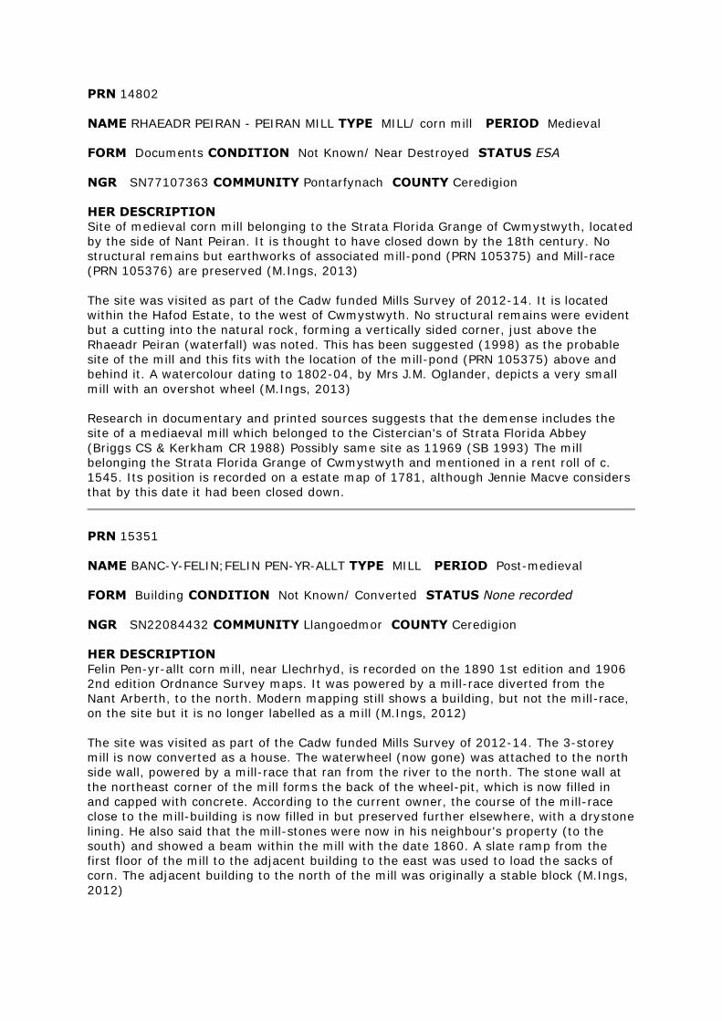
PRN 14802
NAME RHAEADR PEIRAN - PEIRAN MILL TYPE MILL/ corn mill PERIOD Medieval
FORM Documents CONDITION Not Known/ Near Destroyed STATUS ESA
NGR SN77107363 COMMUNITY Pontarfynach COUNTY Ceredigion
HER DESCRIPTION
Site of medieval corn mill belonging to the Strata Florida Grange of Cwmystwyth, located
by the side of Nant Peiran. It is thought to have closed down by the 18th century. No
structural remains but earthworks of associated mill-pond (PRN 105375) and Mill-race
(PRN 105376) are preserved (M.Ings, 2013)
The site was visited as part of the Cadw funded Mills Survey of 2012-14. It is located
within the Hafod Estate, to the west of Cwmystwyth. No structural remains were evident
but a cutting into the natural rock, forming a vertically sided corner, just above the
Rhaeadr Peiran (waterfall) was noted. This has been suggested (1998) as the probable
site of the mill and this fits with the location of the mill-pond (PRN 105375) above and
behind it. A watercolour dating to 1802-04, by Mrs J.M. Oglander, depicts a very small
mill with an overshot wheel (M.Ings, 2013)
Research in documentary and printed sources suggests that the demense includes the
site of a mediaeval mill which belonged to the Cistercian's of Strata Florida Abbey
(Briggs CS & Kerkham CR 1988) Possibly same site as 11969 (SB 1993) The mill
belonging the Strata Florida Grange of Cwmystwyth and mentioned in a rent roll of c.
1545. Its position is recorded on a estate map of 1781, although Jennie Macve considers
that by this date it had been closed down.
PRN 15351
NAME BANC-Y-FELIN;FELIN PEN-YR-ALLT TYPE MILL PERIOD Post-medieval
FORM Building CONDITION Not Known/ Converted STATUS None recorded
NGR SN22084432 COMMUNITY Llangoedmor COUNTY Ceredigion
HER DESCRIPTION
Felin Pen-yr-allt corn mill, near Llechrhyd, is recorded on the 1890 1st edition and 1906
2nd edition Ordnance Survey maps. It was powered by a mill-race diverted from the
Nant Arberth, to the north. Modern mapping still shows a building, but not the mill-race,
on the site but it is no longer labelled as a mill (M.Ings, 2012)
The site was visited as part of the Cadw funded Mills Survey of 2012-14. The 3-storey
mill is now converted as a house. The waterwheel (now gone) was attached to the north
side wall, powered by a mill-race that ran from the river to the north. The stone wall at
the northeast corner of the mill forms the back of the wheel-pit, which is now filled in
and capped with concrete. According to the current owner, the course of the mill-race
close to the mill-building is now filled in but preserved further elsewhere, with a drystone
lining. He also said that the mill-stones were now in his neighbour's property (to the
south) and showed a beam within the mill with the date 1860. A slate ramp from the
first floor of the mill to the adjacent building to the east was used to load the sacks of
corn. The adjacent building to the north of the mill was originally a stable block (M.Ings,
2012)
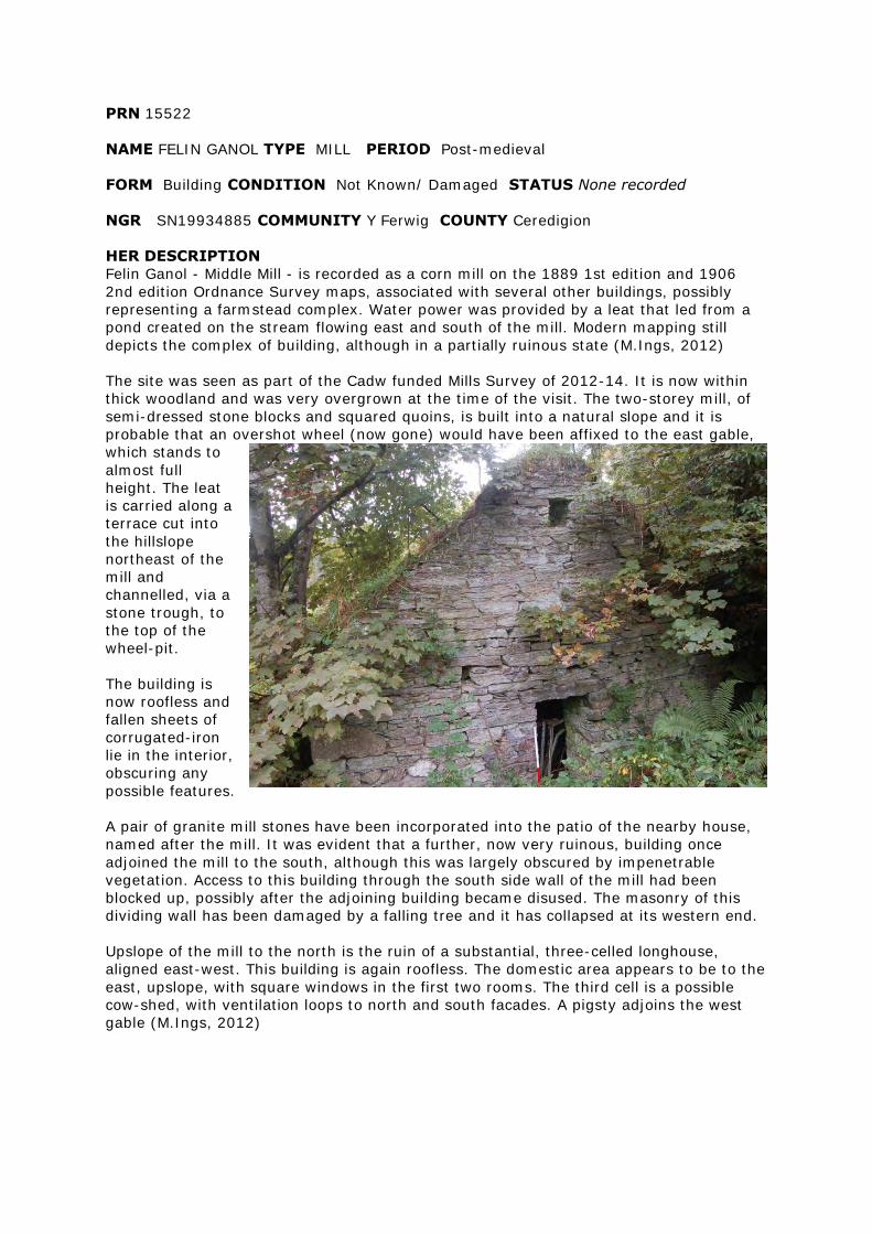
PRN 15522
NAME FELIN GANOL TYPE MILL PERIOD Post-medieval
FORM Building CONDITION Not Known/ Damaged STATUS None recorded
NGR SN19934885 COMMUNITY Y Ferwig COUNTY Ceredigion
HER DESCRIPTION
Felin Ganol - Middle Mill - is recorded as a corn mill on the 1889 1st edition and 1906
2nd edition Ordnance Survey maps, associated with several other buildings, possibly
representing a farmstead complex. Water power was provided by a leat that led from a
pond created on the stream flowing east and south of the mill. Modern mapping still
depicts the complex of building, although in a partially ruinous state (M.Ings, 2012)
The site was seen as part of the Cadw funded Mills Survey of 2012-14. It is now within
thick woodland and was very overgrown at the time of the visit. The two-storey mill, of
semi-dressed stone blocks and squared quoins, is built into a natural slope and it is
probable that an overshot wheel (now gone) would have been affixed to the east gable,
which stands to
almost full
height. The leat
is carried along a
terrace cut into
the hillslope
northeast of the
mill and
channelled, via a
stone trough, to
the top of the
wheel-pit.
The building is
now roofless and
fallen sheets of
corrugated-iron
lie in the interior,
obscuring any
possible features.
A pair of granite mill stones have been incorporated into the patio of the nearby house,
named after the mill. It was evident that a further, now very ruinous, building once
adjoined the mill to the south, although this was largely obscured by impenetrable
vegetation. Access to this building through the south side wall of the mill had been
blocked up, possibly after the adjoining building became disused. The masonry of this
dividing wall has been damaged by a falling tree and it has collapsed at its western end.
Upslope of the mill to the north is the ruin of a substantial, three-celled longhouse,
aligned east-west. This building is again roofless. The domestic area appears to be to the
east, upslope, with square windows in the first two rooms. The third cell is a possible
cow-shed, with ventilation loops to north and south facades. A pigsty adjoins the west
gable (M.Ings, 2012)
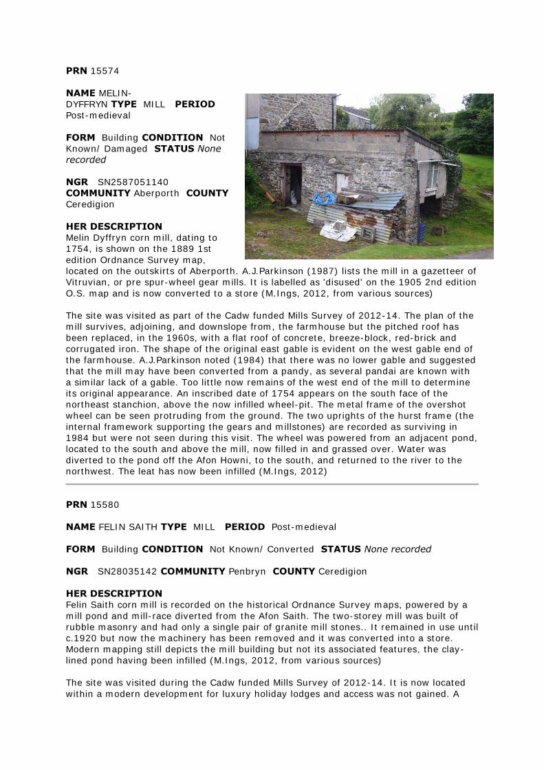
PRN 15574
NAME MELIN-
DYFFRYN TYPE MILL PERIOD
Post-medieval
FORM Building CONDITION Not
Known/ Damaged STATUS None
recorded
NGR SN2587051140
COMMUNITY Aberporth COUNTY
Ceredigion
HER DESCRIPTION
Melin Dyffryn corn mill, dating to
1754, is shown on the 1889 1st
edition Ordnance Survey map,
located on the outskirts of Aberporth. A.J.Parkinson (1987) lists the mill in a gazetteer of
Vitruvian, or pre spur-wheel gear mills. It is labelled as 'disused' on the 1905 2nd edition
O.S. map and is now converted to a store (M.Ings, 2012, from various sources)
The site was visited as part of the Cadw funded Mills Survey of 2012-14. The plan of the
mill survives, adjoining, and downslope from, the farmhouse but the pitched roof has
been replaced, in the 1960s, with a flat roof of concrete, breeze-block, red-brick and
corrugated iron. The shape of the original east gable is evident on the west gable end of
the farmhouse. A.J.Parkinson noted (1984) that there was no lower gable and suggested
that the mill may have been converted from a pandy, as several pandai are known with
a similar lack of a gable. Too little now remains of the west end of the mill to determine
its original appearance. An inscribed date of 1754 appears on the south face of the
northeast stanchion, above the now infilled wheel-pit. The metal frame of the overshot
wheel can be seen protruding from the ground. The two uprights of the hurst frame (the
internal framework supporting the gears and millstones) are recorded as surviving in
1984 but were not seen during this visit. The wheel was powered from an adjacent pond,
located to the south and above the mill, now filled in and grassed over. Water was
diverted to the pond off the Afon Howni, to the south, and returned to the river to the
northwest. The leat has now been infilled (M.Ings, 2012)
PRN 15580
NAME FELIN SAITH TYPE MILL PERIOD Post-medieval
FORM Building CONDITION Not Known/ Converted STATUS None recorded
NGR SN28035142 COMMUNITY Penbryn COUNTY Ceredigion
HER DESCRIPTION
Felin Saith corn mill is recorded on the historical Ordnance Survey maps, powered by a
mill pond and mill-race diverted from the Afon Saith. The two-storey mill was built of
rubble masonry and had only a single pair of granite mill stones.. It remained in use until
c.1920 but now the machinery has been removed and it was converted into a store.
Modern mapping still depicts the mill building but not its associated features, the clay-
lined pond having been infilled (M.Ings, 2012, from various sources)
The site was visited during the Cadw funded Mills Survey of 2012-14. It is now located
within a modern development for luxury holiday lodges and access was not gained. A
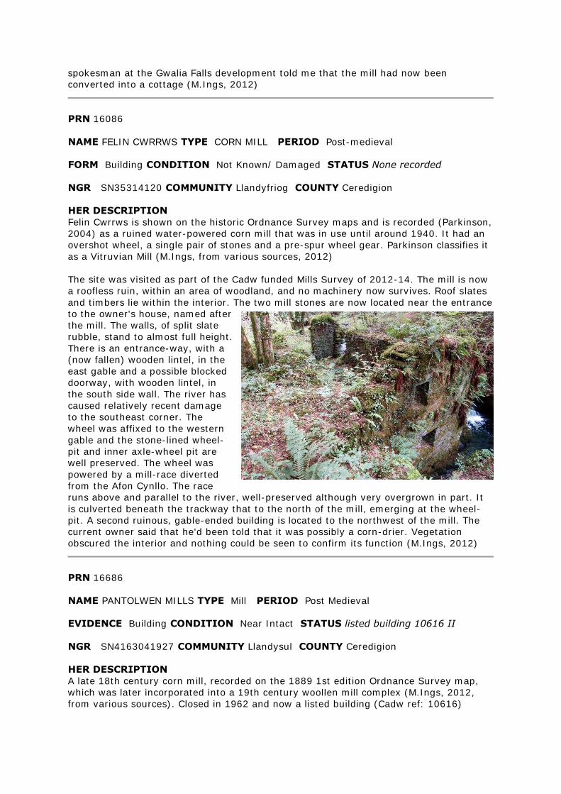
spokesman at the Gwalia Falls development told me that the mill had now been
converted into a cottage (M.Ings, 2012)
PRN 16086
NAME FELIN CWRRWS TYPE CORN MILL PERIOD Post-medieval
FORM Building CONDITION Not Known/ Damaged STATUS None recorded
NGR SN35314120 COMMUNITY Llandyfriog COUNTY Ceredigion
HER DESCRIPTION
Felin Cwrrws is shown on the historic Ordnance Survey maps and is recorded (Parkinson,
2004) as a ruined water-powered corn mill that was in use until around 1940. It had an
overshot wheel, a single pair of stones and a pre-spur wheel gear. Parkinson classifies it
as a Vitruvian Mill (M.Ings, from various sources, 2012)
The site was visited as part of the Cadw funded Mills Survey of 2012-14. The mill is now
a roofless ruin, within an area of woodland, and no machinery now survives. Roof slates
and timbers lie within the interior. The two mill stones are now located near the entrance
to the owner's house, named after
the mill. The walls, of split slate
rubble, stand to almost full height.
There is an entrance-way, with a
(now fallen) wooden lintel, in the
east gable and a possible blocked
doorway, with wooden lintel, in
the south side wall. The river has
caused relatively recent damage
to the southeast corner. The
wheel was affixed to the western
gable and the stone-lined wheel-
pit and inner axle-wheel pit are
well preserved. The wheel was
powered by a mill-race diverted
from the Afon Cynllo. The race
runs above and parallel to the river, well-preserved although very overgrown in part. It
is culverted beneath the trackway that to the north of the mill, emerging at the wheel-
pit. A second ruinous, gable-ended building is located to the northwest of the mill. The
current owner said that he'd been told that it was possibly a corn-drier. Vegetation
obscured the interior and nothing could be seen to confirm its function (M.Ings, 2012)
PRN 16686
NAME PANTOLWEN MILLS TYPE Mill PERIOD Post Medieval
EVIDENCE Building CONDITION Near Intact STATUS listed building 10616 II
NGR SN4163041927 COMMUNITY Llandysul COUNTY Ceredigion
HER DESCRIPTION
A late 18th century corn mill, recorded on the 1889 1st edition Ordnance Survey map,
which was later incorporated into a 19th century woollen mill complex (M.Ings, 2012,
from various sources). Closed in 1962 and now a listed building (Cadw ref: 10616)
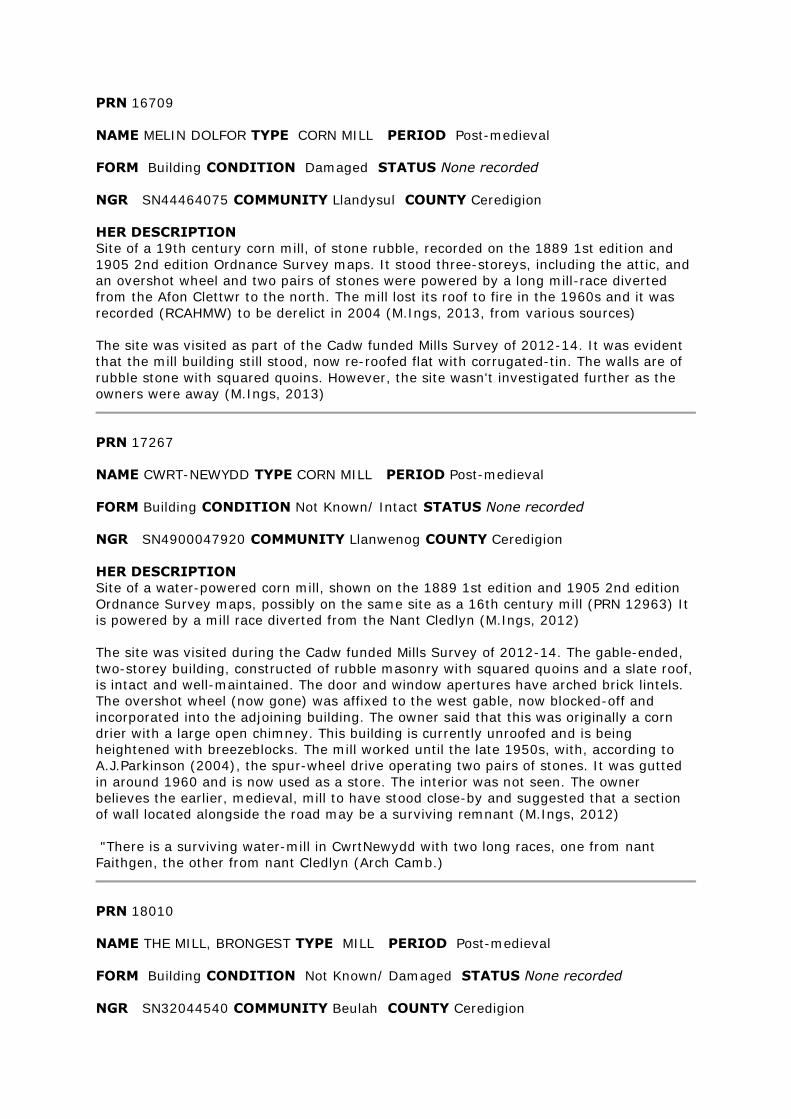
PRN 16709
NAME MELIN DOLFOR TYPE CORN MILL PERIOD Post-medieval
FORM Building CONDITION Damaged STATUS None recorded
NGR SN44464075 COMMUNITY Llandysul COUNTY Ceredigion
HER DESCRIPTION
Site of a 19th century corn mill, of stone rubble, recorded on the 1889 1st edition and
1905 2nd edition Ordnance Survey maps. It stood three-storeys, including the attic, and
an overshot wheel and two pairs of stones were powered by a long mill-race diverted
from the Afon Clettwr to the north. The mill lost its roof to fire in the 1960s and it was
recorded (RCAHMW) to be derelict in 2004 (M.Ings, 2013, from various sources)
The site was visited as part of the Cadw funded Mills Survey of 2012-14. It was evident
that the mill building still stood, now re-roofed flat with corrugated-tin. The walls are of
rubble stone with squared quoins. However, the site wasn't investigated further as the
owners were away (M.Ings, 2013)
PRN 17267
NAME CWRT-NEWYDD TYPE CORN MILL PERIOD Post-medieval
FORM Building CONDITION Not Known/ Intact STATUS None recorded
NGR SN4900047920 COMMUNITY Llanwenog COUNTY Ceredigion
HER DESCRIPTION
Site of a water-powered corn mill, shown on the 1889 1st edition and 1905 2nd edition
Ordnance Survey maps, possibly on the same site as a 16th century mill (PRN 12963) It
is powered by a mill race diverted from the Nant Cledlyn (M.Ings, 2012)
The site was visited during the Cadw funded Mills Survey of 2012-14. The gable-ended,
two-storey building, constructed of rubble masonry with squared quoins and a slate roof,
is intact and well-maintained. The door and window apertures have arched brick lintels.
The overshot wheel (now gone) was affixed to the west gable, now blocked-off and
incorporated into the adjoining building. The owner said that this was originally a corn
drier with a large open chimney. This building is currently unroofed and is being
heightened with breezeblocks. The mill worked until the late 1950s, with, according to
A.J.Parkinson (2004), the spur-wheel drive operating two pairs of stones. It was gutted
in around 1960 and is now used as a store. The interior was not seen. The owner
believes the earlier, medieval, mill to have stood close-by and suggested that a section
of wall located alongside the road may be a surviving remnant (M.Ings, 2012)
"There is a surviving water-mill in CwrtNewydd with two long races, one from nant
Faithgen, the other from nant Cledlyn (Arch Camb.)
PRN 18010
NAME THE MILL, BRONGEST TYPE MILL PERIOD Post-medieval
FORM Building CONDITION Not Known/ Damaged STATUS None recorded
NGR SN32044540 COMMUNITY Beulah COUNTY Ceredigion
HER DESCRIPTION
The corn mill in Brongest is recorded on the 1889 1st edition and 1905 2nd edition
Ordnance Survey maps, powered by a long mill-race diverted from the river to the north.
The mill is still shown on modern mapping (M.Ings, 2012)
The site was visited during the Cadw funded Mills Survey of 2012-14. The mill building,
of stone rubble with squared quoins and a slate hipped roof, is intact except for the
southeast-facing side which has largely collapsed, exposing that elevation to the
elements. The structure has been propped up but still looks precarious. A single-pitch
extension to the southwest-facing wall was apparently used as a cart-house and there is
a flat-roofed breezeblock extension on the northwest side. The waterwheel, now gone,
was affixed to the northeast-facing wall where there is a brick arch, which would have
sat above the wheel rim, and a square aperture for the wheel axle. The current owners
told me that the mill worked until around the mid-1940s but all the machinery has gone
since at least 1965 and the mill-race has largely been infilled (M.Ings, 2012)
PRN 18023
NAME FELIN CWM TYPE MILL RACE PERIOD Post-medieval
FORM Earthwork CONDITION Not Known/ Damaged STATUS None recorded
NGR SN3456048299 COMMUNITY Troedyraur COUNTY Ceredigion
HER DESCRIPTION
Long mill-race diverted from the Nant Cerdinen to power corn mill Felin Cwm (PRN
21370). The race is recorded on the historic Ordnance Survey maps and is shown on
modern mapping as a drain (M.Ings, 2012)
The site was visited as part of the Cadw funded Mills Survey of 2012-14. The length of
mill-race nearest to the mill and wheel-pit has now been infilled but the stretch across
the fields is preserved as an earthwork, although largely overgrown. The section seen,
just north of the mill complex, was still sharply cut and distinct. The current mill owners
told me that the retaining dam at the head of the race, on neighbouring land, had been
flattened relatively recently. When the mill was working, the mill would own the full
length of the leat, plus a yard either side. The neighbouring farmers would annually give
up a day to help clear it out so that the mill could be kept in almost constant use
(M.Ings, 2012)
PRN 18025
NAME FELIN BRITHDIR TYPE CORN MILL PERIOD Post-medieval
FORM Building CONDITION Not Known STATUS None recorded
NGR SN34204727 COMMUNITY Penbryn COUNTY Ceredigion
HER DESCRIPTION
The corn mill at Brithdir was originally built in 1786 and rebuilt in 1868, operating until
around 1950. The mill is recorded on the historic Ordnance Survey maps, powered by a
long mill-race (PRN 9185), diverted with a sluice gate from the river to the north. The
mill was converted to a house in 1980 (M.Ings, 2012, from various sources)
The mill had an overshot waterwheel that powered two pairs of stones - one French burr,
the other Anglesey granite (M.Ings, 2012, based on A.J.Parkinson, 2004)
PRN 18090
NAME FELIN NANT-Y-PELAU TYPE MILL/ corn mill PERIOD Post-medieval
FORM Building CONDITION Not Known/ Intact STATUS None recorded
NGR SN3715056960 COMMUNITY Llanllwchaiarn COUNTY Ceredigion
HER DESCRIPTION
Felin Nant-y-pelau is recorded as a corn mill on the 1st and 2nd edition Ordnance Survey
maps, alongside a stream to the north of Nanternis. The maps show a leat, to the east of
the mill, leading to a mill-pond and possible dam located immediately behind the mill
building. A sluice controls waterflow to the northeast corner of the mill. The mill is still
depicted on modern mapping (M.Ings, 2012, from various sources)
The mill was visited during the Cadw funded Mills Survey of 2012-14. It is a substantial,
two-storey building of semi-dressed stone with squared quoins and a hipped gable roof,
now under corrugated-iron. There are doorways in the north and south-facing sides and
the west-facing side wall has two groundfloor windows and one, now blocked, first-floor
window. There is also a first-floor doorway, possibly an entrance to a hay-loft, which
looks like a later insertion. In more recent years the mill was turbine driven from the
pond, which is now vegetated over, and some of the working machinery is still in situ
(M.Ings, 2012)
PRN 18272
NAME FELIN-CASTELL-HOWELL TYPE CORN MILL PERIOD Post-medieval
FORM Building CONDITION Not Known/ Damaged STATUS None recorded
NGR SN43974796 COMMUNITY Llandysul
COUNTY Ceredigion
HER DESCRIPTION
Site of a corn mill recorded on the 1889 1st
edition and 1905 2nd edition Ordnance Survey
maps. Identified (1987) as a 'Vitruvian' mill, a
simple water-powered mill using a vertical wheel
linked to a horizontal drive-shaft - first described
by Vitruvius, a Roman engineer in the 1st century
AD. The site is now in a ruinous state (M.Ings,
2012)
The site was recorded as part of the CADW funded
Mill Survey of 2012-14. In 1983 the RCAHMW
described the mill as being relatively intact and
roofed with slate and timbers including a beam
inscribed with the date 1802. The overshot wheel
had gone but the interior machinery - iron pit-
wheel, stone-nut and spindle, and single pair of
granite millstones - survived. The roof of the
square-planned mill, built into the slope of a hill,
has now gone and the walls have partially
collapsed. The northern gable now stands to
almost half the height recorded in 1983, but a
square aperture, through which the waterwheel shaft once drove the pit wheel, still
survives. No features could be seen in the interior, which is now inaccessible and
obscured by stone tumble, thick vegetation and fallen roof timbers. One of the millstones
was evident, largely hidden by tall nettles. Thick vegetation also obscured much of the
north and east exterior walls but the line of the mill-race (PRN 102943) could still be
traced alongside the north gable and across the field to the north. A later outbuilding
abutts the west side of the mill - recorded as a carpenter's workshop in 1983. This is still
roofed and currently used for storage. A second outbuilding to the south is now almost
completely destroyed, with just one corner of masonry still standing (M.Ings, 2012)
PRN 18307
NAME FELIN-BLAENAU TYPE MILL/ corn mill PERIOD Post-medieval
FORM Building CONDITION Not Known/ Near Destroyed STATUS None recorded
NGR SN4756951289 COMMUNITY Llanwenog COUNTY Ceredigion
HER DESCRIPTION
Felin Blaenau corn mill is recorded on the 1889 1st edition Ordnance Survey map as part
of a small complex of three or four buildings within a steep-sided stream valley. Two
buildings are still depicted on the 1905 2nd ed. O.S. but are gone from modern mapping,
the site described (1983) as a ruin in impenetrable forestry plantation (M.Ings, 2012,
from various sources)
The site was visited during the Cadw funded Mills Project of 2012-14. The recorded
location is a wide, level area cut into the hill-slope above a stream, within a forestry
plantation. The only visible remains of a structure comprised some masonry, standing a
maximum 0.30 metres high, at the corner of a possible building platform estimated to
measure some 8 x 6 metres and aligned southwest-northeast. It is feasible that
archaeological deposits are preserved below the ground (M.Ings, 2012)
PRN 18422
NAME FELIN RHIWBREN TYPE CORN MILL PERIOD Post-medieval
FORM Building CONDITION Not Known/ Converted STATUS None recorded
NGR SN47445760 COMMUNITY Llanarth COUNTY Ceredigion
HER DESCRIPTION
Felin Rhiwbren corn mill is shown on the 1889 1st edition and 1905 2nd edition
Ordnance Survey maps. It is powered by a mill-race diverted from the Nant Rhyd-y-
beirdd, leading to a mill pond immediately above the mill to the west. The mill building is
still shown on modern mapping and was recorded in 2004 (RCAHMW) to be two-storey,
of local rubble masonry and derelict, formerly with an overshot wheel (M.Ings, 2012,
from various sources)
The site was visited during the Cadw funded Mills Survey of 2012-14. Unfortunately the
owners were away so only a very rapid view was possible. The mill building looked intact
and well maintained, possibly converted for domestic use. It is a gable-ended structure
built into the steep slope of the riverbank and the roof is now under corrugated-iron. The
wheel-pit looked to be on the on the northern gable end but thick vegetation prevented
a clear view. The mill pond has mainly been grassed over, although a much smaller,
ornamental pond survives within its outline, which is still evident in the topography. The
line of the mill-race was also preserved, leading from the southern end of the pond as a
grassed pathway (M.Ings, 2012)
PRN 18475
NAME LLYFFANOG TYPE MILL/ corn mill PERIOD Post-medieval
FORM Building CONDITION Not Known/ Damaged STATUS None recorded
NGR SN4259457015 COMMUNITY Llanarth COUNTY Ceredigion
HER DESCRIPTION
Corn mill recorded on the 1890 1st edition and 1905 2nd edition Ordnance Survey maps.
It looks to be powered by a mill-race diverted from the river to the south, with a possible
wheel on the southwest-facing end wall. A building is still shown at the site on modern
mapping, although it does not appear to correspond to the same footprint (M.Ings,
2013)
The site was visited during the Cadw funded Mills Survey of 2012-14. Unfortunately the
owners were away so a close look at the building wasn't possible. However, it was
possible to see that the mill still stood in the same 'T' shape as shown on the historic
maps. It is of rubble stone, whitewashed, with squared quoins and is now roofed with
corrugated tin. A neighbour said that the leat above the mill is preserved and that the
mill stones are still within the building (M.Ings, 2013)
PRN 18649
NAME FELIN LLWYN-OWEN TYPE MILL RACE PERIOD Post-medieval
FORM Documents CONDITION Not Known STATUS None recorded
NGR SN534632 COMMUNITY Dyffryn Arth COUNTY Ceredigion
HER DESCRIPTION
Mill-race recorded on the historic Ordnance Survey maps associated with corn mill Felin
Llwynywen (PRN 18655) (M.Ings, 2013)
PRN 18655
NAME FELIN LLWYN-OWEN TYPE CORN MILL PERIOD Post-medieval
FORM Building CONDITION Not Known STATUS None recorded
NGR SN53406325 COMMUNITY Dyffryn Arth COUNTY Ceredigion
HER DESCRIPTION
Site of a corn mill recorded on the historic Ordnance Survey maps powered by a long
mill-race (PRN 18649), diverted from the Afon Arth to the southeast, and a mill-pond
located to the north of the mill building (M.Ings, 2013)
PRN 18832
NAME FELIN-TRAWSNANT TYPE MILL/ corn mill PERIOD Post-medieval
FORM Building CONDITION Not Known/ Intact STATUS None recorded
NGR SN5629967072 COMMUNITY Llanrhystyd COUNTY Ceredigion
HER DESCRIPTION
Site of a corn mill recorded on the 1888 1st edition and 1905 2nd edition Ordnance
Survey maps, powered by a mill-race diverted from the Afon Peris to the southeast and
a holding pond located just to the southeast of the mill building. A building is still shown
on modern mapping and recent aerial photographs (Ordnance Survey Next Perspectives,
2009) indicate that it may be restored/converted. The area of the mill pond is now under
trees and the mill race appears to survive, in part at least, as an earthwork (M.Ings,
2013)
PRN 18957
NAME FELIN-SAINT TYPE MILL/ cottage PERIOD Post-medieval
FORM Building CONDITION Not Known/ Damaged STATUS None recorded
NGR SN62367100 COMMUNITY Llangwyryfon COUNTY Ceredigion
HER DESCRIPTION
'Melin-saint' is a cottage recorded on the 1888 1st edition Ordnance Survey map, sited
on the north bank of the Afon Wyre. By the time of the 1905 2nd edition OS the name is
recorded as Felin Saint. The building is still roofed, with a possible outbuilding adjoining
its northeast side wall. Modern mapping shows the building to now be ruinous and it is
located within woodland (M.Ings, 2013)
The site was visited as part of the Cadw funded Mills Survey of 2012-14. The building
recorded on the historic maps as Melin/Felin Saint is not a mill but a ruinous cottage with
an attached pigsty. The current owner believes the mill, from which the house must have
taken its name, to have been located on the other side of the Afon Wyre but no evidence
for this site, or any associated water-management features, were found (M.Ings, 2013).
PRN 18962
NAME LLEDROD TYPE MILL RACE PERIOD Post-medieval
FORM Documents CONDITION Not Known STATUS None recorded
NGR SN6450170095 COMMUNITY Lledrod COUNTY Ceredigion
HER DESCRIPTION
A mill leat associated with an old corn mill, shown on the 1963 Ordnance Survey map.
PRN 19000
NAME FELIN-LLANGYBI TYPE MILL/ FARMSTEAD PERIOD Post-medieval
FORM Building CONDITION Not Known/ Near Destroyed STATUS None recorded
NGR SN60245235 COMMUNITY Llangybi COUNTY Ceredigion
HER DESCRIPTION
A farmstead complex of three buildings with the Felin Llangybi is recorded on the 1888
1st edition Ordnance Survey map. This layout appears to have altered by the time of the
1905 2nd edition OS and the farmstead has changed its name to Maesyderi on modern
mapping (M.Ings, 2012, from various sources)
The site was visited during the Cadw funded Mills Survey of 2012-14. There is no mill
building at the farmstead and the current owner believes the name 'Felin-Llangybi'
derives from a former feed store that used to operate from the site. This was of
corrugated-iron construction and stood just to the north of the existing complex, beside
the access track. This building has now gone and, when the feed business ended, the
farm's name was changed to Maesyderi (M.Ings, 2012)
PRN 19077
NAME FELIN FAWR TYPE MILL/ corn mill PERIOD Post-medieval
FORM Building CONDITION Not Known/ Damaged STATUS None recorded
NGR SN60225824 COMMUNITY Llangeitho COUNTY Ceredigion
HER DESCRIPTION
Felin Fawr corn mill is recorded on the 1889 1st edition and 1905 2nd edition Ordnance
Survey maps, powered by a long mill race diverted from the Afon Aeron to the east. The
site is still shown on modern mapping (M.Ings, 2013)
The site was visited as part of the Cadw funded Mills project of 2012-14. The stone
building still stands but its height has been lowered relatively recently as it was in
danger of collapse. The highest remaining stone courses in the walls have been
consolidated and the building is now roofed with corrugated-iron. There is a doorway and
two windows in the east-facing sidewall and a very low, square aperture, with a timber
lintel, in the north-facing gable. A corrugated-iron shed stands adjacent to the west -
facing sidewall. An iron waterwheel frame stands against the south-facing gable, with a
low arched hole for the axle. The mill-race still runs down to the mill and the area was
very silted/flooded but it appeared that the wheel would have been undershot.
Internally, the floor is concreted and currently used for storage, obscuring much of the
inner walls. A small fireplace was noted in the southwest corner. No surviving internal
machinery was evident. The mill-race was traced, as a silted ditch, for a little distance to
the east of the mill but overgrowth and access problems prevented further exploration
(M.Ings, 2013)
PRN 19125
NAME FELIN RHYD-Y-PANDY TYPE FULLING MILL/ corn mill PERIOD Post-medieval/
Early Medieval
FORM Building CONDITION Not Known/ Converted STATUS None recorded
NGR SN63616227 COMMUNITY Llangeitho COUNTY Ceredigion
HER DESCRIPTION
Felin Rhyd-y-pandy is recorded on the historic Ordnance Survey maps as a component of
a farmstead complex. It is powered by a mill race diverted from the Afon Aeron, with a
holding pond located just to the north. It is dated 1837 but may have earlier, 18th
century origins (M.Ings, 2013, from various sources)
The site was visited as part of the Cadw funded Mills Survey of 2012-14. Unfortunately
the owners were away so a detailed survey of the mill was not possible. It is a gable-
ended stone building standing below/cut into a steep bank at the north corner of the
farmstead complex, extended to the southeast to form an 'L'-shaped building and
adjoined by further farm buildings to the southwest. There is a wide doorway in the
southwest facing gable, now with a solid wood door, and several glazed windows in the
southeast facing gable of the extension. The slate roof looked relatively recent. The
holding pond is above the mill, at its northern corner, and it would have powered an
overshot wheel located against the northeast-facing wall. An aperture with a stone lintel,
possibly for the wheel axle, was noted within this elevation but the wheel itself has gone.
The earthwork remnant of the holding pond, now infilled and vegetated, is preserved and
the mill-race was evident as a substantial earthwork following the hill contour to the
north of the mill. It is not known what, if any, mill machinery survives as the interior was
not seen. A record from 1984 (A.J.Parkinson, RCAHMW) describes a spur wheel and
gearing powering two millstones, one French burr and one granite, although much of the
workings were not visible. At this time, the waterwheel was also still present. A third pair
of stones was recorded in the extension during a second visit. The building is obviously
no longer functioning as a mill but is being maintained and in use as part of the farm
(M.Ings, 2013).
PRN 19146
NAME MELIN-UCHELDRE TYPE Mill PERIOD Post Medieval
EVIDENCE Building CONDITION Converted STATUS None recorded
NGR SN67207661 COMMUNITY Trawsgoed COUNTY Ceredigion
HER DESCRIPTION
Melin-ucheldre is recorded on the 1888 1st edition and 1905 2nd edition Ordnance
Survey maps. Modern maps and a recent (2008) aerial photograph suggest that the mill
is now incorporated within a residential dwelling (M.Ings, 2012, from various sources)
A water mill shown on the 1964 Ordnance Survey map. Present use and condition not
known.
PRN 19147
NAME FELIN FAWR TYPE MILL/ corn mill PERIOD Post-medieval
FORM Documents CONDITION Not Known STATUS None recorded
NGR SN67577884 COMMUNITY Melindwr COUNTY Ceredigion
HER DESCRIPTION
Felin Fawr corn mill is recorded on the 1888 1st edition and 1905 2nd edition Ordnance
Survey maps, powered by a mill-race diverted from the river to the east. The mill is not
shown on modern mapping and the site is obscured by tree cover on recent (2009,
Ordnance Survey Next Perspectives) aerial photographs (M.Ings, 2013)
An old water mill shown on the 1964 Ordnance Survey map. Present usage and condition
unknown.
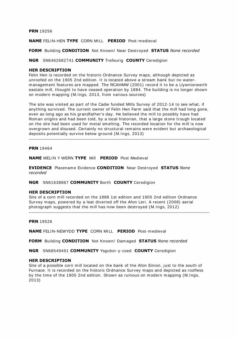
PRN 19256
NAME FELIN-HEN TYPE CORN MILL PERIOD Post-medieval
FORM Building CONDITION Not Known/ Near Destroyed STATUS None recorded
NGR SN6462682741 COMMUNITY Trefeurig COUNTY Ceredigion
HER DESCRIPTION
Felin Hen is recorded on the historic Ordnance Survey maps, although depicted as
unroofed on the 1905 2nd edition. It is located above a stream bank but no water-
management features are mapped. The RCAHMW (2001) record it to be a Llywniorwerth
eastate mill, thought to have ceased operation by 1884. The building is no longer shown
on modern mapping (M.Ings, 2013, from various sources)
The site was visited as part of the Cadw funded Mills Survey of 2012-14 to see what, if
anything survived. The current owner of Felin Hen Farm said that the mill had long gone,
even as long ago as his grandfather's day. He believed the mill to possibly have had
Roman origins and had been told, by a local historian, that a large stone trough located
on the site had been used for metal smelting. The recorded location for the mill is now
overgrown and disused. Certainly no structural remains were evident but archaeological
deposits potentially survive below ground (M.Ings, 2013)
PRN 19464
NAME MELIN Y WERN TYPE Mill PERIOD Post Medieval
EVIDENCE Placename Evidence CONDITION Near Destroyed STATUS None
recorded
NGR SN61638867 COMMUNITY Borth COUNTY Ceredigion
HER DESCRIPTION
Site of a corn mill recorded on the 1888 1st edition and 1905 2nd edition Ordnance
Survey maps, powered by a leat diverted off the Afon Leri. A recent (2008) aerial
photograph suggests that the mill has now been destroyed (M.Ings, 2012)
PRN 19526
NAME FELIN-NEWYDD TYPE CORN MILL PERIOD Post-medieval
FORM Building CONDITION Not Known/ Damaged STATUS None recorded
NGR SN68549491 COMMUNITY Ysgubor-y-coed COUNTY Ceredigion
HER DESCRIPTION
Site of a possible corn mill located on the bank of the Afon Einion, just to the south of
Furnace. It is recorded on the historic Ordnance Survey maps and depicted as roofless
by the time of the 1905 2nd edition. Shown as ruinous on modern mapping (M.Ings,
2013)
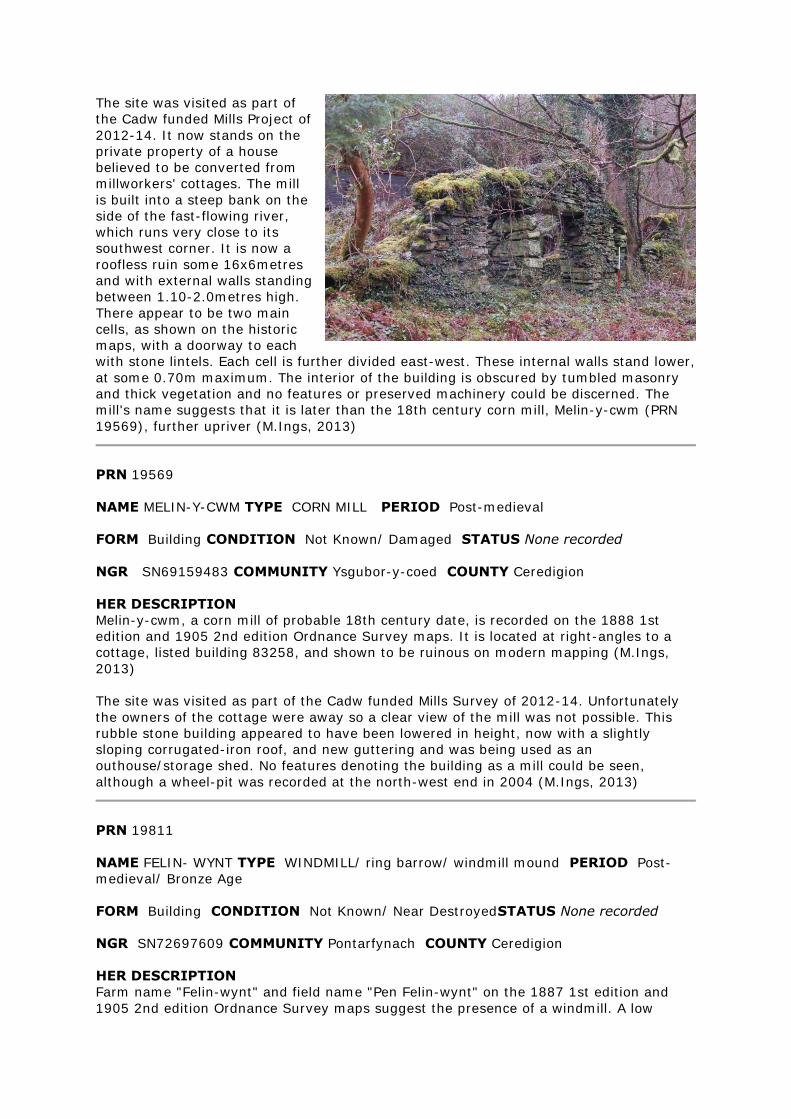
The site was visited as part of
the Cadw funded Mills Project of
2012-14. It now stands on the
private property of a house
believed to be converted from
millworkers' cottages. The mill
is built into a steep bank on the
side of the fast-flowing river,
which runs very close to its
southwest corner. It is now a
roofless ruin some 16x6metres
and with external walls standing
between 1.10-2.0metres high.
There appear to be two main
cells, as shown on the historic
maps, with a doorway to each
with stone lintels. Each cell is further divided east-west. These internal walls stand lower,
at some 0.70m maximum. The interior of the building is obscured by tumbled masonry
and thick vegetation and no features or preserved machinery could be discerned. The
mill's name suggests that it is later than the 18th century corn mill, Melin-y-cwm (PRN
19569), further upriver (M.Ings, 2013)
PRN 19569
NAME MELIN-Y-CWM TYPE CORN MILL PERIOD Post-medieval
FORM Building CONDITION Not Known/ Damaged STATUS None recorded
NGR SN69159483 COMMUNITY Ysgubor-y-coed COUNTY Ceredigion
HER DESCRIPTION
Melin-y-cwm, a corn mill of probable 18th century date, is recorded on the 1888 1st
edition and 1905 2nd edition Ordnance Survey maps. It is located at right-angles to a
cottage, listed building 83258, and shown to be ruinous on modern mapping (M.Ings,
2013)
The site was visited as part of the Cadw funded Mills Survey of 2012-14. Unfortunately
the owners of the cottage were away so a clear view of the mill was not possible. This
rubble stone building appeared to have been lowered in height, now with a slightly
sloping corrugated-iron roof, and new guttering and was being used as an
outhouse/storage shed. No features denoting the building as a mill could be seen,
although a wheel-pit was recorded at the north-west end in 2004 (M.Ings, 2013)
PRN 19811
NAME FELIN- WYNT TYPE WINDMILL/ ring barrow/ windmill mound PERIOD Post-
medieval/ Bronze Age
FORM Building CONDITION Not Known/ Near DestroyedSTATUS None recorded
NGR SN72697609 COMMUNITY Pontarfynach COUNTY Ceredigion
HER DESCRIPTION
Farm name "Felin-wynt" and field name "Pen Felin-wynt" on the 1887 1st edition and
1905 2nd edition Ordnance Survey maps suggest the presence of a windmill. A low
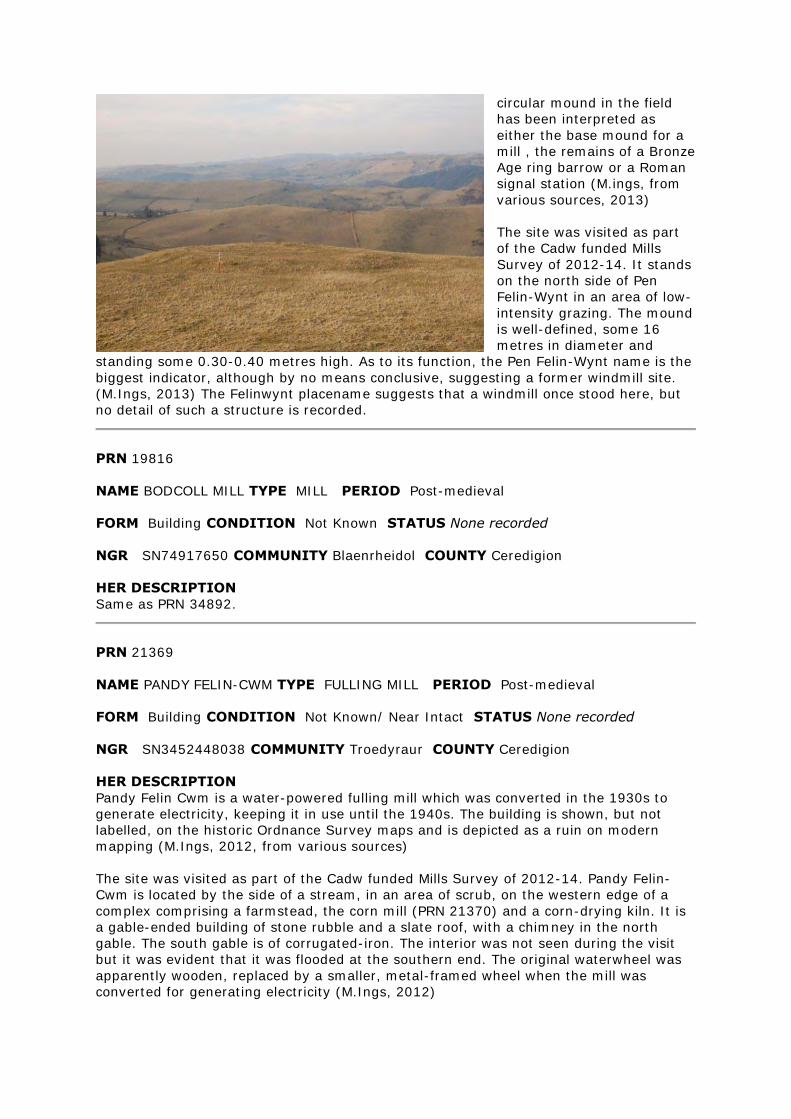
circular mound in the field
has been interpreted as
either the base mound for a
mill , the remains of a Bronze
Age ring barrow or a Roman
signal station (M.ings, from
various sources, 2013)
The site was visited as part
of the Cadw funded Mills
Survey of 2012-14. It stands
on the north side of Pen
Felin-Wynt in an area of low-
intensity grazing. The mound
is well-defined, some 16
metres in diameter and
standing some 0.30-0.40 metres high. As to its function, the Pen Felin-Wynt name is the
biggest indicator, although by no means conclusive, suggesting a former windmill site.
(M.Ings, 2013) The Felinwynt placename suggests that a windmill once stood here, but
no detail of such a structure is recorded.
PRN 19816
NAME BODCOLL MILL TYPE MILL PERIOD Post-medieval
FORM Building CONDITION Not Known STATUS None recorded
NGR SN74917650 COMMUNITY Blaenrheidol COUNTY Ceredigion
HER DESCRIPTION
Same as PRN 34892.
PRN 21369
NAME PANDY FELIN-CWM TYPE FULLING MILL PERIOD Post-medieval
FORM Building CONDITION Not Known/ Near Intact STATUS None recorded
NGR SN3452448038 COMMUNITY Troedyraur COUNTY Ceredigion
HER DESCRIPTION
Pandy Felin Cwm is a water-powered fulling mill which was converted in the 1930s to
generate electricity, keeping it in use until the 1940s. The building is shown, but not
labelled, on the historic Ordnance Survey maps and is depicted as a ruin on modern
mapping (M.Ings, 2012, from various sources)
The site was visited as part of the Cadw funded Mills Survey of 2012-14. Pandy Felin-
Cwm is located by the side of a stream, in an area of scrub, on the western edge of a
complex comprising a farmstead, the corn mill (PRN 21370) and a corn-drying kiln. It is
a gable-ended building of stone rubble and a slate roof, with a chimney in the north
gable. The south gable is of corrugated-iron. The interior was not seen during the visit
but it was evident that it was flooded at the southern end. The original waterwheel was
apparently wooden, replaced by a smaller, metal-framed wheel when the mill was
converted for generating electricity (M.Ings, 2012)
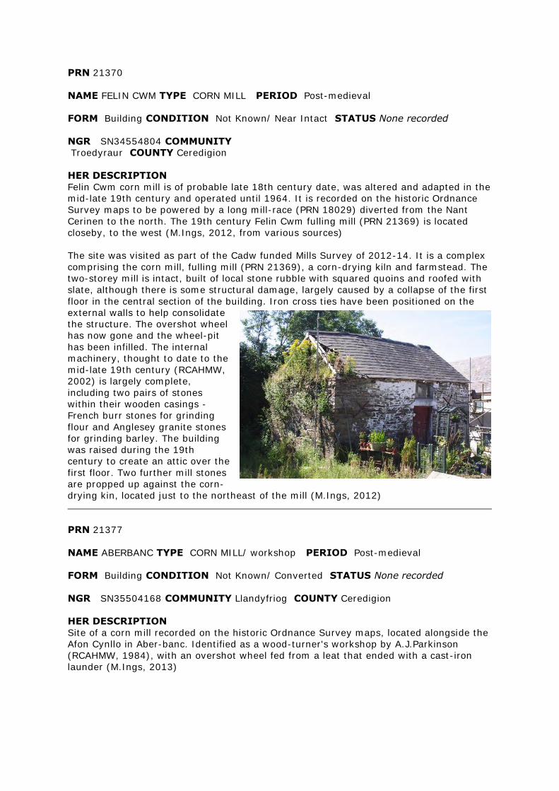
PRN 21370
NAME FELIN CWM TYPE CORN MILL PERIOD Post-medieval
FORM Building CONDITION Not Known/ Near Intact STATUS None recorded
NGR SN34554804 COMMUNITY
Troedyraur COUNTY Ceredigion
HER DESCRIPTION
Felin Cwm corn mill is of probable late 18th century date, was altered and adapted in the
mid-late 19th century and operated until 1964. It is recorded on the historic Ordnance
Survey maps to be powered by a long mill-race (PRN 18029) diverted from the Nant
Cerinen to the north. The 19th century Felin Cwm fulling mill (PRN 21369) is located
closeby, to the west (M.Ings, 2012, from various sources)
The site was visited as part of the Cadw funded Mills Survey of 2012-14. It is a complex
comprising the corn mill, fulling mill (PRN 21369), a corn-drying kiln and farmstead. The
two-storey mill is intact, built of local stone rubble with squared quoins and roofed with
slate, although there is some structural damage, largely caused by a collapse of the first
floor in the central section of the building. Iron cross ties have been positioned on the
external walls to help consolidate
the structure. The overshot wheel
has now gone and the wheel-pit
has been infilled. The internal
machinery, thought to date to the
mid-late 19th century (RCAHMW,
2002) is largely complete,
including two pairs of stones
within their wooden casings -
French burr stones for grinding
flour and Anglesey granite stones
for grinding barley. The building
was raised during the 19th
century to create an attic over the
first floor. Two further mill stones
are propped up against the corn-
drying kin, located just to the northeast of the mill (M.Ings, 2012)
PRN 21377
NAME ABERBANC TYPE CORN MILL/ workshop PERIOD Post-medieval
FORM Building CONDITION Not Known/ Converted STATUS None recorded
NGR SN35504168 COMMUNITY Llandyfriog COUNTY Ceredigion
HER DESCRIPTION
Site of a corn mill recorded on the historic Ordnance Survey maps, located alongside the
Afon Cynllo in Aber-banc. Identified as a wood-turner's workshop by A.J.Parkinson
(RCAHMW, 1984), with an overshot wheel fed from a leat that ended with a cast-iron
launder (M.Ings, 2013)
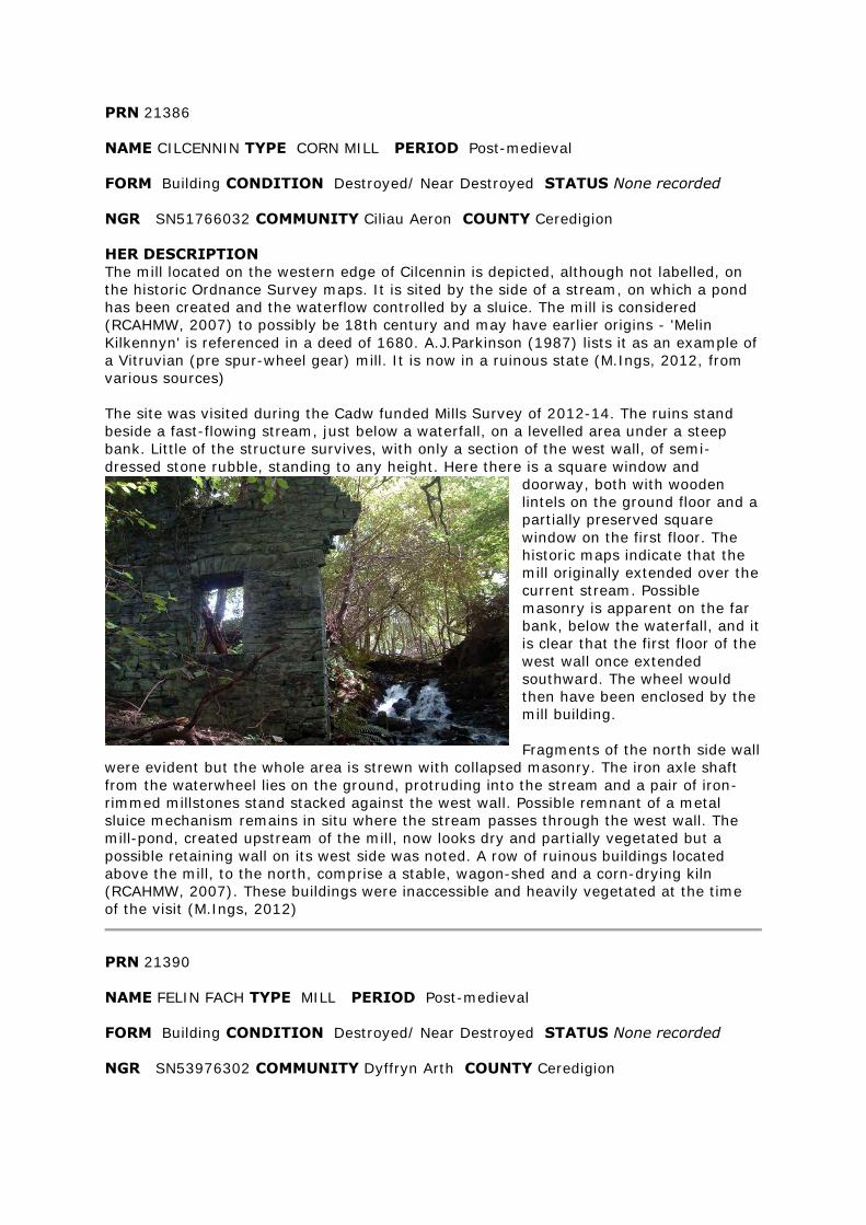
PRN 21386
NAME CILCENNIN TYPE CORN MILL PERIOD Post-medieval
FORM Building CONDITION Destroyed/ Near Destroyed STATUS None recorded
NGR SN51766032 COMMUNITY Ciliau Aeron COUNTY Ceredigion
HER DESCRIPTION
The mill located on the western edge of Cilcennin is depicted, although not labelled, on
the historic Ordnance Survey maps. It is sited by the side of a stream, on which a pond
has been created and the waterflow controlled by a sluice. The mill is considered
(RCAHMW, 2007) to possibly be 18th century and may have earlier origins - 'Melin
Kilkennyn' is referenced in a deed of 1680. A.J.Parkinson (1987) lists it as an example of
a Vitruvian (pre spur-wheel gear) mill. It is now in a ruinous state (M.Ings, 2012, from
various sources)
The site was visited during the Cadw funded Mills Survey of 2012-14. The ruins stand
beside a fast-flowing stream, just below a waterfall, on a levelled area under a steep
bank. Little of the structure survives, with only a section of the west wall, of semi-
dressed stone rubble, standing to any height. Here there is a square window and
doorway, both with wooden
lintels on the ground floor and a
partially preserved square
window on the first floor. The
historic maps indicate that the
mill originally extended over the
current stream. Possible
masonry is apparent on the far
bank, below the waterfall, and it
is clear that the first floor of the
west wall once extended
southward. The wheel would
then have been enclosed by the
mill building.
Fragments of the north side wall
were evident but the whole area is strewn with collapsed masonry. The iron axle shaft
from the waterwheel lies on the ground, protruding into the stream and a pair of iron-
rimmed millstones stand stacked against the west wall. Possible remnant of a metal
sluice mechanism remains in situ where the stream passes through the west wall. The
mill-pond, created upstream of the mill, now looks dry and partially vegetated but a
possible retaining wall on its west side was noted. A row of ruinous buildings located
above the mill, to the north, comprise a stable, wagon-shed and a corn-drying kiln
(RCAHMW, 2007). These buildings were inaccessible and heavily vegetated at the time
of the visit (M.Ings, 2012)
PRN 21390
NAME FELIN FACH TYPE MILL PERIOD Post-medieval
FORM Building CONDITION Destroyed/ Near Destroyed STATUS None recorded
NGR SN53976302 COMMUNITY Dyffryn Arth COUNTY Ceredigion
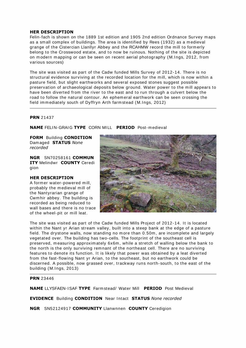
HER DESCRIPTION
Felin-fach is shown on the 1889 1st edition and 1905 2nd edition Ordnance Survey maps
as a small complex of buildings. The area is identified by Rees (1932) as a medieval
grange of the Cistercian Llanllyr Abbey and the RCAHMW record the mill to formerly
belong to the Crosswood estate, and to now be ruinous. Nothing of the site is depicted
on modern mapping or can be seen on recent aerial photography (M.Ings, 2012, from
various sources)
The site was visited as part of the Cadw funded Mills Survey of 2012-14. There is no
structural evidence surviving at the recorded location for the mill, which is now within a
pasture field, but slight earthworks and several exposed stones suggest possible
preservation of archaeological deposits below ground. Water power to the mill appears to
have been diverted from the river to the east and to run through a culvert below the
road to follow the natural contour. An ephemeral earthwork can be seen crossing the
field immediately south of Dyffryn Arth farmstead (M.Ings, 2012)
PRN 21437
NAME FELIN-GRAIG TYPE CORN MILL PERIOD Post-medieval
FORM Building CONDITION
Damaged STATUS None
recorded
NGR SN70258161 COMMUN
ITY Melindwr COUNTY Ceredi
gion
HER DESCRIPTION
A former water-powered mill,
probably the medieval mill of
the Nantyrarian grange of
Cwmhir abbey. The building is
recorded as being reduced to
wall bases and there is no trace
of the wheel-pit or mill leat.
The site was visited as part of the Cadw funded Mills Project of 2012-14. It is located
within the Nant yr Arian stream valley, built into a steep bank at the edge of a pasture
field. The drystone walls, now standing no more than 0.50m, are incomplete and largely
vegetated over. The building has two-cells. The footprint of the southeast cell is
preserved, measuring approximately 6x6m, while a stretch of walling below the bank to
the north is the only surviving remnant of the northeast cell. There are no surviving
features to denote its function. It is likely that power was obtained by a leat diverted
from the fast-flowing Nant yr Arian, to the southeast, but no earthwork could be
discerned. A possible, now grassed over, trackway runs north-south, to the east of the
building (M.Ings, 2013)
PRN 23446
NAME LLYSFAEN-ISAF TYPE Farmstead/ Water Mill PERIOD Post Medieval
EVIDENCE Building CONDITION Near Intact STATUS None recorded
NGR SN52124917 COMMUNITY Llanwnnen COUNTY Ceredigion
HER DESCRIPTION
19th century farmstead recorded on the 1889 1st edition and 1905 2nd edition Ordnance
Survey maps which included a leat driven waterwheel to power machinery (M.Ings,
2012, from various sources)
PRN 24378
NAME GWAR CWM TYPE Mill/ Cottage PERIOD Post Medieval
EVIDENCE / Earthwork CONDITION Damaged/ Near Destroyed STATUS None
recorded
NGR SN6542580974 COMMUNITY Melindwr COUNTY Ceredigion
HER DESCRIPTION
A two-celled building, aligned north-south, with a possible outbuilding to the southwest
is recorded on the 1888 1st edition Ordnance Survey map. A reservoir is located to the
northeast of this building, with a sluice-controlled leat running to the north to power
barn machinery at Llwyniorwerth Uchaf, to the west. The buildings are not shown on the
1905 2nd edition OS or on modern mapping (M.Ings, 2012, from various sources))
A field visit in 2006 could not identify a clear platform for the site of the building
(M.Ings, 2012)
A dam and leat on the stream and an apparently associated rock-cut platform, may
signify the site of a former corn mill, but no detail of such a mill is known.
PRN 24582
NAME CWM GLAS TYPE MILL PERIOD Post-medieval
FORM Building CONDITION Near Destroyed STATUS None recorded
NGR SN7392474333 COMMUNITY Pontarfynach COUNTY Ceredigion
HER DESCRIPTION
Cwm-glas, on the bank of the Nant Cell, is recorded on the 1888 1st edition, as a 'U'-
shaped building and 1905 2nd edition Ordnance Survey maps, as an 'L'-shaped building
with separate outbuilding to the northwest. Modern maps depict the building to now be
ruinous and it is obscured by trees on recent (2009, Ordnance Survey Next Perspectives)
aerial photographs (M.Ings, 2013)
The site was visited as part of the Cadw funded Mills Survey of 2012-14. It is fenced off
from the surrounding rough pasture, on a level platform cut into the bank above Nant
Cell. The walls generally stand less than a metre high, forming two cells with a doorway
in the south-facing side. The interior is obscured by stone tumble and vegetation. A
possible wheel-pit is located adjacent to the west-facing end wall that presumably
contained an overshot wheel. There is a square aperture in the wall for the wheel axle. A
curved metal rim was noted, largely obscured, on the inside of this wall - possibly
banding from around a mill stone. A short section of the leat feeding the wheel-pit was
evident but could not be traced far with any certainty (M.Ings, 2013)
The ruins of Cwm Glas corn Mill are found on the east bank of the Nant Cell about 1.5km
north of Pontrhydygroes. JH July 2002
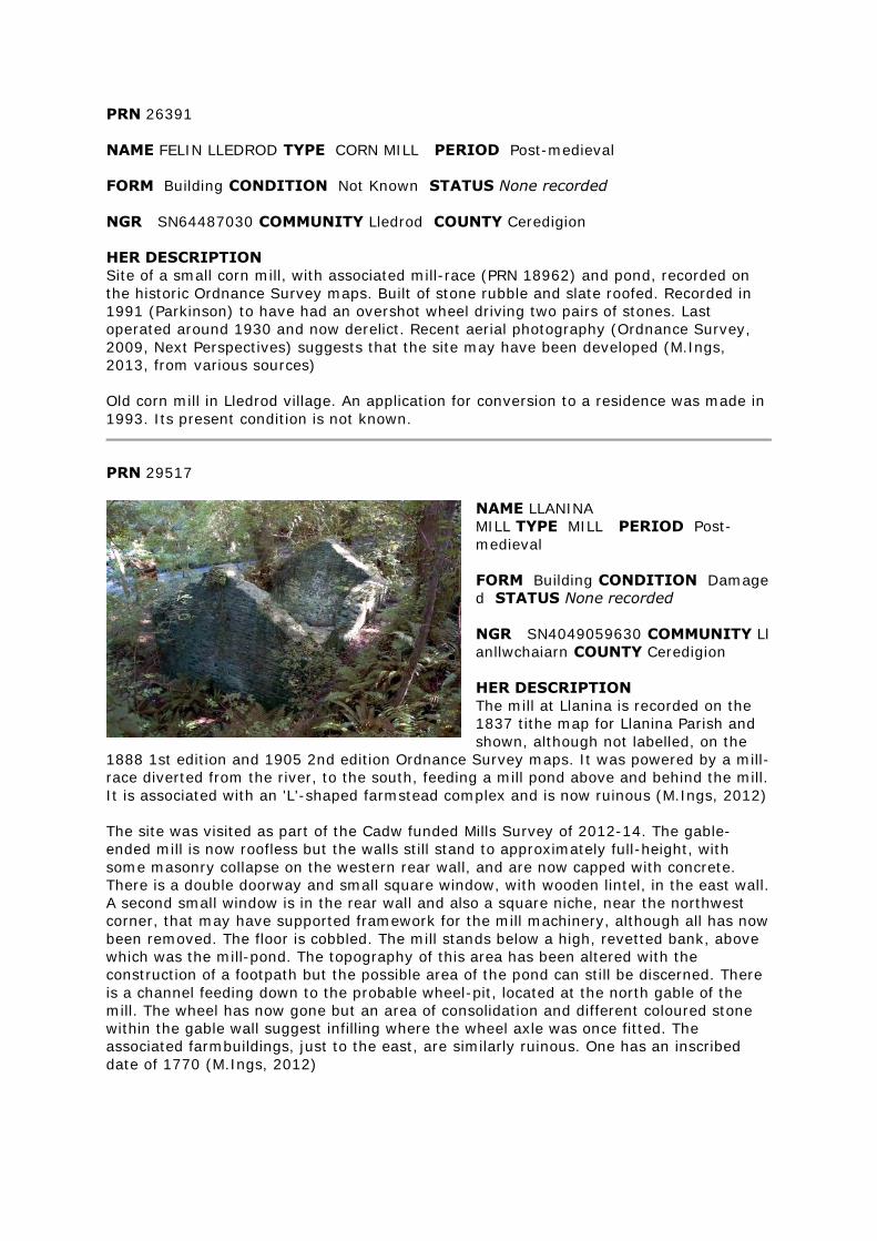
PRN 26391
NAME FELIN LLEDROD TYPE CORN MILL PERIOD Post-medieval
FORM Building CONDITION Not Known STATUS None recorded
NGR SN64487030 COMMUNITY Lledrod COUNTY Ceredigion
HER DESCRIPTION
Site of a small corn mill, with associated mill-race (PRN 18962) and pond, recorded on
the historic Ordnance Survey maps. Built of stone rubble and slate roofed. Recorded in
1991 (Parkinson) to have had an overshot wheel driving two pairs of stones. Last
operated around 1930 and now derelict. Recent aerial photography (Ordnance Survey,
2009, Next Perspectives) suggests that the site may have been developed (M.Ings,
2013, from various sources)
Old corn mill in Lledrod village. An application for conversion to a residence was made in
1993. Its present condition is not known.
PRN 29517
NAME LLANINA
MILL TYPE MILL PERIOD Post-
medieval
FORM Building CONDITION Damage
d STATUS None recorded
NGR SN4049059630 COMMUNITY Ll
anllwchaiarn COUNTY Ceredigion
HER DESCRIPTION
The mill at Llanina is recorded on the
1837 tithe map for Llanina Parish and
shown, although not labelled, on the
1888 1st edition and 1905 2nd edition Ordnance Survey maps. It was powered by a mill-
race diverted from the river, to the south, feeding a mill pond above and behind the mill.
It is associated with an 'L'-shaped farmstead complex and is now ruinous (M.Ings, 2012)
The site was visited as part of the Cadw funded Mills Survey of 2012-14. The gable-
ended mill is now roofless but the walls still stand to approximately full-height, with
some masonry collapse on the western rear wall, and are now capped with concrete.
There is a double doorway and small square window, with wooden lintel, in the east wall.
A second small window is in the rear wall and also a square niche, near the northwest
corner, that may have supported framework for the mill machinery, although all has now
been removed. The floor is cobbled. The mill stands below a high, revetted bank, above
which was the mill-pond. The topography of this area has been altered with the
construction of a footpath but the possible area of the pond can still be discerned. There
is a channel feeding down to the probable wheel-pit, located at the north gable of the
mill. The wheel has now gone but an area of consolidation and different coloured stone
within the gable wall suggest infilling where the wheel axle was once fitted. The
associated farmbuildings, just to the east, are similarly ruinous. One has an inscribed
date of 1770 (M.Ings, 2012)
PRN 34892
NAME FELIN BODCOLL;FELIN TY'N LLWYN TYPE CORN MILL/ WOOLLEN
MILL PERIOD Post-medieval
FORM Documents CONDITION Damaged STATUS ESA
NGR SN74927651 COMMUNITY Blaenrheidol COUNTY Ceredigion
HER DESCRIPTION
Bodcoll Mill is recorded on the 1887 1st edition Ordnance Survey map as a woollen mill.
It was converted from a corn mill, with probable medieval origins, in the early 19th
century. By the time of the 1905 2nd edition OS it is shown to be disused and the site is
now recorded as ruinous (M.Ings, 2013)
Ruinous site comprising remains of cottage and mill buildings, but poorly preserved.
Wheel pit (for an overshot wheel) and millrace survive and also a subterranean tailrace
outflow from the wheel pit back to the river. Birthplace of the Rev. Dafydd Morgan, who
was responsible for the great Methodist Revival of 1859. Was a corn-mill originally but
converted to a woollen factory by 1881 - according to the evidence of the parish census
returns (P Sambrook)
PRN 42633
NAME PENTRE MILL TYPE LEAT PERIOD Post-medieval
FORM Earthwork CONDITION Near Intact STATUS ESA
NGR SN78997379 COMMUNITY Pontarfynach COUNTY Ceredigion
HER DESCRIPTION
Leat that taps into the Ystwyth and fed the Pentre Mill. A weir appears to exist in the
river at SN79407383 and from here there must have been a wooden launder taking
water into the first section of the leat, which is rock cut. The leat course is interrupted
some 200m downstream by a late 19th century ore crushing installation associated with
Cwmystwyth lead mine.
PRN 42770
NAME LLUEST TYPE MILL PERIOD Post-medieval
FORM None CONDITION Near Destroyed STATUS None recorded
NGR SN6501166860 COMMUNITY Lledrod COUNTY Ceredigion
HER DESCRIPTION
Lluest corn mill is recorded on the 1888 1st edition Ordnance Survey map, located
alongside the Afon Hirfain, to the east of Bronnant. A mill-race (PRN 42771) diverts from
the river to the west of the mill, feeding an extensive mill pond (PRN 42772) located
immediately south of the mill building. The 1905 2nd edition O.S. suggests that the mill
was out of use by this time. The building is shown as possibly roofless and is not labelled
as a mill. The area of the mill pond is now much smaller, with the surrounds now shown
as marshy. The mill-race is not labelled. Nothing of the mill or its associated features is
depicted on modern mapping (M.Ings, 2012)
The site was visited during the Cadw funded Mills Survey of 2012-14. The owner, at
Lluest-fach, knew of no structural remains but remembered his grandfather talking of a
watermill on the farm. No remains are preserved above ground but there is a possible
building platform surviving at the recorded location, with a sharp bank sloping down to
the river. To the south of this, a hollowed area under woodland may represent the now
dried, vegetated mill pond (M.Ings, 2012)
PRN 42771
NAME LLUEST TYPE MILL RACE PERIOD Post-medieval
FORM Documents CONDITION Not known STATUS None recorded
NGR SN6497566879 COMMUNITY Lledrod COUNTY Ceredigion
HER DESCRIPTION
A mill leat associated with Lluest mill, shown on the 1891 Ordnance Survey map.
PRN 42772
NAME LLUEST TYPE MILL POND PERIOD Post-medieval
FORM Documents CONDITION STATUS None recorded
NGR SN6496666886 COMMUNITY Lledrod COUNTY Ceredigion
HER DESCRIPTION
The mill pond of Lluest mill, shown on the 1891 Ordnance Survey map.
PRN 57441
NAME WATERMILL AT GLANDWR,MYDROILYN ROAD,CASTELL HYWEL TYPE Water
Mill PERIOD Post Medieval
EVIDENCE Building CONDITION Near Intact STATUS listed building 10593 II
NGR SN4459249036 COMMUNITY Llandysul COUNTY Ceredigion
HER DESCRIPTION
A late 19th century watermill, recorded on the 1889 1st edition and 1905 2nd edition
Ordnance Survey maps, that retains its large iron, formerly overshot, wheel. (M.Ings,
2012, from various sources)
Grade II listed water mill
PRN 57516
NAME MELYN SYNOD,SYNOD MILL TYPE Water Mill PERIOD Post Medieval
EVIDENCE Building CONDITION Near Intact STATUS listed building 10683 II
NGR SN3903454660 COMMUNITY Llanllwchaiarn COUNTY Ceredigion
HER DESCRIPTION
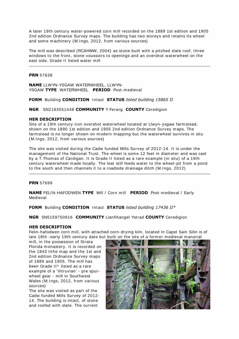
A later 19th century water-powered corn mill recorded on the 1889 1st edition and 1905
2nd edition Ordnance Survey maps. The building has two storeys and retains its wheel
and some machinery (M.Ings, 2012, from various sources)
The mill was described (RCAHMW, 2004) as stone built with a pitched slate roof, three
windows to the front, stone voussoirs to openings and an overshot waterwheel on the
east side. Grade II listed water mill
PRN 57638
NAME LLWYN-YSGAW WATERWHEEL, LLWYN-
YSGAW TYPE WATERWHEEL PERIOD Post-medieval
FORM Building CONDITION Intact STATUS listed building 15865 II
NGR SN2183551448 COMMUNITY Y Ferwig COUNTY Ceredigion
HER DESCRIPTION
Site of a 19th century iron overshot waterwheel located at Llwyn-ysgaw farmstead,
shown on the 1890 1st edition and 1905 2nd edition Ordnance Survey maps. The
farmstead is no longer shown on modern mapping but the waterwheel survives in situ
(M.Ings, 2012, from various sources)
The site was visited during the Cadw funded Mills Survey of 2012-14. It is under the
management of the National Trust. The wheel is some 12 feet in diameter and was cast
by a T.Thomas of Cardigan. It is Grade II listed as a rare example (in situ) of a 19th
century waterwheel made locally. The leat still feeds water to the wheel-pit from a pond
to the south and then channels it to a roadside drainage ditch (M.Ings, 2012)
PRN 57699
NAME FELIN-HAFODWEN TYPE Mill / Corn mill PERIOD Post-medieval / Early
Medieval
FORM Building CONDITION Intact STATUS listed building 17436 II*
NGR SN5159750916 COMMUNITY Llanfihangel Ystrad COUNTY Ceredigion
HER DESCRIPTION
Felin-hafodwen corn mill, with attached corn-drying kiln, located in Capel Sain Silin is of
late 18th -early 19th century date but built on the site of a former medieval manorial
mill, in the possession of Strata
Florida monastery. It is recorded on
the 1843 tithe map and the 1st and
2nd edition Ordnance Survey maps
of 1889 and 1905. The mill has
been Grade II* listed as a rare
example of a 'Vitruvian' - pre spur-
wheel gear - mill in Southwest
Wales (M.Ings, 2012, from various
sources)
The site was visited as part of the
Cadw funded Mills Survey of 2012-
14. The building is intact, of stone
and roofed with slate. The current
owner told me that the mill-race and mill-pond (above and to the northwest of the mill)
have been infilled. The overshot wheel is still in situ, on the rear gable, with a launder in
place above it. It was apparently converted to an overshot from a breastshot wheel in
the 1830s. The current wheel is cast-iron and its shaft has been repaired at least three
times. The internal machinery is mostly intact, with the hurst frame containing the iron
pit wheel and stone nut on the the ground floor and a pair of millstones (one now
propped against the wall) on the first floor. The roadside room of the building has a
fireplace in the front wall. The owner believes this to have originally been an area for
butter-blending and was separate from the mill - a doorway has since been inserted
through the dividing wall. The adjoining corn-drying kiln, on the southeast side of the
mill, is thought to be a later addition built between 1875 and 1905. The mill is currently
used as a workshop and for storage (M.Ings, 2012)
PRN 102943
NAME FELIN-CASTELL-HOWELL TYPE MILL RACE PERIOD Post-Medieval
FORM Earthwork CONDITION Near Intact STATUS None recorded
NGR SN43984804 COMMUNITY Llandysul COUNTY Ceredigion
HER DESCRIPTION
Mill-race diverted from the Clettwr Fach to power Felin Castell-Howell corn mill. Recorded on the 1889 1st edition and 1905 2nd edition Ordnance Survey maps (M.Ings, 2012)
The site was visited during the Cadw Mill project of 2012-14. The mill race is cut into the
hillslope north of the mill and runs down alongside the north gable, where the wheel was
once attached, before being channelled back to the river. The earthwork is still distinct
and sharply cut, particularly near the building where the outside bank stands some 0.80
metres high. It is recorded (1983) that the launder was carried to the overshot wheel on
beams in the gable. Much of the gable has now collapsed but one of the beam slots is
still evident (M.Ings, 2012)
PRN 102944
NAME FELIN NEWYDD TYPE corn mill PERIOD Post-Medieval
FORM Documents CONDITION Near Destroyed STATUS None recorded
NGR SN58886107 COMMUNITY Nantcwnlle COUNTY Ceredigion
HER DESCRIPTION
Felin-newydd, possibly a small water-powered corn mill (RCAHMW 2007) is recorded on
the 1890 1st edition and 1905 2nd edition Ordnance Survey maps, sited alongside a
trackway leading from Llan-Feilog farmstead. The source of power to run a mill here is
not made clear, although there are watercourses to the east, south and west of the
buildings. Two buildings are depicted, with an associated well. The well is still recorded
on modern mapping but not the buildings and the site is believed to have been demolished (M.Ings, from various sources, 2012)
The site was visited during the Cadw funded Mills Survey of 2012-14. The owners, at
Llan-faelog farm, told me that the mill had been demolished and the stone taken for use
elsewhere. The well was located, a chamber set into the bank alongside the track, but no
structural remains of the mill buildings were evident. There is a level area at the
recorded location, within woodland, but the current pathway runs right across the mill
site. Thick undergrowth obscures the woodland floor and it is possible that building
foundations lie beneath the surface (M.Ings, 2012)
PRN 102946
NAME BLAENFFOREST TYPE wheel pit PERIOD Post-Medieval
FORM Other Structure CONDITION Intact STATUS None recorded
NGR SN31893761 COMMUNITY Cenarth COUNTY Ceredigion
HER DESCRIPTION
Site of a 19th century waterwheel used to power a chaff-cutter and threshing-machine at
Blaenfforest famstead (M.Ings, 2012)
The site was visited during the Cadw funded Mills Survey of 2012-14. The setting for the
waterwheel is below a steep bank in woodland below Blaenfforest Farm. The overshot
wheel itself has now gone but the stone-lined wheel-pit survives, with a squared niche in
the southeastern wall showing where the wheel axle was affixed. The water to power the
wheel is collected from the river, southwest of the wheel, into a pond and then
channelled along a leat, the line of which can still be followed, although heavily silted
and vegetated, as it follows the contours through the woods. It cuts sharply downslope
to the top of the wheel-pit and there is a channel leading from the pit back to the river.
The previous owner of Blaenfforest remembers the wheel working, connected by a long
spindle to the stable-loft to drive a chaff-cutter and small threshing machine. He also
recalled a grinding mill that used cast-iron plates. The lower part of the stable is still
preserved (M.Ings, 2012)
PRN 102950
NAME LLANDEWI BREFI CORN MILL TYPE corn mill PERIOD Post-Medieval
FORM Building CONDITION Converted STATUS None recorded
NGR SN66055528 COMMUNITY Llanddewi Brefi COUNTY Ceredigion
HER DESCRIPTION
Llandewi Brefi corn mill is recorded (RCAHMW,1951) as a rough, grey-stone building with
an iron and wood, overshot wheel powering two pairs of stone. The wheel is described as
ruined and the mill as derelict. The site is not marked as a mill on the historical Ordnance Survey maps (M.Ings, 2012)
The site was visited during the Cadw Funded Mills Survey of 2012-14. The mill building
has now been converted (since about 1980) to a private house. The plan of the mill has
been preserved but the height of the building has been raised. The new section is
rendered and the original stonework has been left exposed. An arched entrance at the
south end once led through to the overshot wheel, powered by water from a mill-pond
located above and behind the house, which is now grassed over. A local historian
believes that there was possibly an earlier wheel chamber on the north end of the house,
an area apparently now sealed off. Unfortunately the owners of the house were not in at
the time of the visit. An engraved stone on the front of the building reads 'Erasmus Js
1816'. The water was brought to the mill-pond by a mill-race (PRN 102951) diverted from the river to the north. (M.Ings, 2012)
PRN 102951
NAME LLANDEWI BREFI CORN MILL TYPE mill race PERIOD Post-Medieval
FORM Other Structure CONDITION Damaged STATUS None recorded
NGR SN66195532 COMMUNITY Llanddewi Brefi COUNTY Ceredigion
HER DESCRIPTION
A mill-race diverted from the river in the northwest of Llandewi Brefi to power the corn
mill (PRN 102951) and woollen mill (M.Ings, 2012)
The site was visited during the Cadw funded Mills Survey of 2012-14. The mill-race is
diverted from the river by way of a weir, which remains intact, and its course can largely
be followed through the village as a footpath or a boundary ditch although property does
impinge on to it occasionally. Some sections of the stone wall that retained the race are
preserved. It reaches the mill-pond, now grassed-over, above and behind the corn mill
(PRN 102950) The leat continues to the east towards the woollen mill. It could be seen
as an indistinct earthwork in the field, named Dol-y-felin - field of the mill - bordering
the river. An excavation of the woollen mill was being conducted at the time of the visit
and the archaeologist looking at the site believed the race to run to a second pond, just
to the west (M.Ings, 2012)
PRN 102952
NAME ABERDAUDDWR MILL TYPE corn mill PERIOD Post-Medieval
FORM Building CONDITION Damaged STATUS None recorded
NGR SN57026196 COMMUNITY Nantcwnlle COUNTY Ceredigion
HER DESCRIPTION
The 1890 1st edition Ordnance Survey map records Felin Newydd corn mill, located to
the south of Bethania, as a small complex of three buildings. The name of the site has
changed to 'Aberdauddwr Mill' by the time of the 1905 2nd edition O.S. map . The mill is
shown to be powered by water diverted by an aqueduct from the stream to the south. The mill is still shown on modern mapping, although partially in ruin (M.Ings, 2012)
The site was visited as part of the Cadw funded Mills Survey of 2012-14. The gable-
ended mill building, of stone rubble with squared quoins, is undergoing consolidation and
repair. It has recently been repointed and the damaged wall tops have been built up with
breezeblocks and red bricks. The roof has new timbers and is now of corrugated-iron.
The southwest corner of the mill has been altered with the original corner removed and
an angled breeze-blocked entrance inserted. The floor is concreted and a new loft floor
has been put in. All the mill machinery has gone and the building is currently used as a
workshop and for storage. There is now a wide entrance in the north wall, although the
masonry to its right-hand side indicates that this is not the original width of the
doorway. The waterwheel was affixed to the east gable and the owner told me that the
water was supplied in a trough, across what is now her back garden, from the nearby
stream. The wheel and trough have been removed, although the former is believed to lie
in a neighbour's field just across the road. The west gable of the mill adjoins a granary
store and the south wall has a (now blocked) doorway through to a small building with a chimney in its west wall. (M.Ings, 2012
PRN 105360
NAME FELIN FACH TYPE mill pond PERIOD Post-Medieval
FORM Earthwork CONDITION Near Intact STATUS None recorded
NGR SN53476712 COMMUNITY Llansantffraid COUNTY Ceredigion
HER DESCRIPTION
Mill pond at Felin Fach (PRN 4807) recorded on the 1888 1st edition and 1905 2nd
edition Ordnance Survey maps. Still shown in outline on modern mapping (M.Ings,
2013)
The site was seen during a visit to Felin Fach as part of the Cadw funded Mills Survey of
2012-14. The extent of the mill-pond is still evident as an earthwork in the woods, now
heavily silted, possibly deliberately infilled, and vegetated. A stone wall along the edge
of the bank above the mill still stands to some 0.60 metres high (M.Ings, 2013)
PRN 105361
NAME FELIN FACH TYPE weir PERIOD Post-Medieval
FORM Other Structure CONDITION Near Intact STATUS None recorded
NGR SN53646718 COMMUNITY Llansantffraid COUNTY Ceredigion
HER DESCRIPTION
A weir on the Afon Peris recorded on the 1888 1st edition and 1905 2nd edition
Ordnance Survey maps. Used to divert water from the river to the mill-race (PRN
105362) associated with Felin Fach (PRN 4807) Still shown on modern mapping (M.Ings,
2013)
The weir was seen as part of a site visit to Felin Fach during the Cadw funded Mills
Survey of 2012-14. It comprises two linear area of stone that channel the river as it
drops a level. Presumably the flow would have been controlled by a sluice but no
evidence for this was seen. The entrance to the mill-race is still clear (M.Ings, 2013)
PRN 105362
NAME FELIN FACH TYPE mill race PERIOD Post-Medieval
FORM Earthwork CONDITION Near Intact STATUS None recorded
NGR SN53566712 COMMUNITY Llansantffraid COUNTY Ceredigion
HER DESCRIPTION
Mill race diverted from the Afon Peris at weir (PRN 105361) to provide water power to
Felin Fach (PRN 4807) The race is recorded on the 1888 1st edition and 1905 2nd edition
Ordnance Survey maps (M.Ings, 2013)
The mill race was seen during a site visit to Felin Fach, as part of the Cadw funded Mills
Survey of 2012-14. It can still be followed as it runs parallel and above the river through
woodland from the weir (PRN 105361) to the preserved earthwork of a mill pond (PRN
105360) located above the mill. It is carved into the hillslope and, although heavily silted
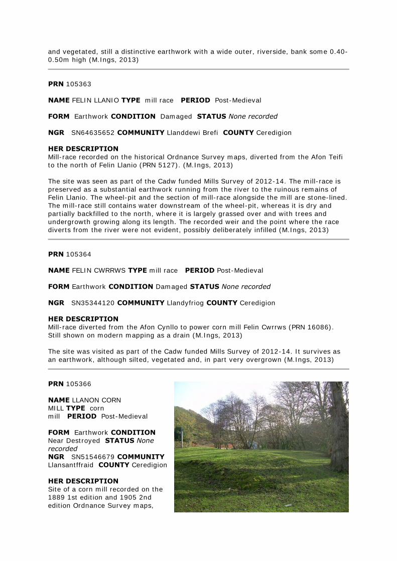
and vegetated, still a distinctive earthwork with a wide outer, riverside, bank some 0.40-
0.50m high (M.Ings, 2013)
PRN 105363
NAME FELIN LLANIO TYPE mill race PERIOD Post-Medieval
FORM Earthwork CONDITION Damaged STATUS None recorded
NGR SN64635652 COMMUNITY Llanddewi Brefi COUNTY Ceredigion
HER DESCRIPTION
Mill-race recorded on the historical Ordnance Survey maps, diverted from the Afon Teifi
to the north of Felin Llanio (PRN 5127). (M.Ings, 2013)
The site was seen as part of the Cadw funded Mills Survey of 2012-14. The mill-race is
preserved as a substantial earthwork running from the river to the ruinous remains of
Felin Llanio. The wheel-pit and the section of mill-race alongside the mill are stone-lined.
The mill-race still contains water downstream of the wheel-pit, whereas it is dry and
partially backfilled to the north, where it is largely grassed over and with trees and
undergrowth growing along its length. The recorded weir and the point where the race
diverts from the river were not evident, possibly deliberately infilled (M.Ings, 2013)
PRN 105364
NAME FELIN CWRRWS TYPE mill race PERIOD Post-Medieval
FORM Earthwork CONDITION Damaged STATUS None recorded
NGR SN35344120 COMMUNITY Llandyfriog COUNTY Ceredigion
HER DESCRIPTION
Mill-race diverted from the Afon Cynllo to power corn mill Felin Cwrrws (PRN 16086).
Still shown on modern mapping as a drain (M.Ings, 2013)
The site was visited as part of the Cadw funded Mills Survey of 2012-14. It survives as
an earthwork, although silted, vegetated and, in part very overgrown (M.Ings, 2013)
PRN 105366
NAME LLANON CORN
MILL TYPE corn
mill PERIOD Post-Medieval
FORM Earthwork CONDITION
Near Destroyed STATUS None
recorded
NGR SN51546679 COMMUNITY
Llansantffraid COUNTY Ceredigion
HER DESCRIPTION
Site of a corn mill recorded on the
1889 1st edition and 1905 2nd
edition Ordnance Survey maps,
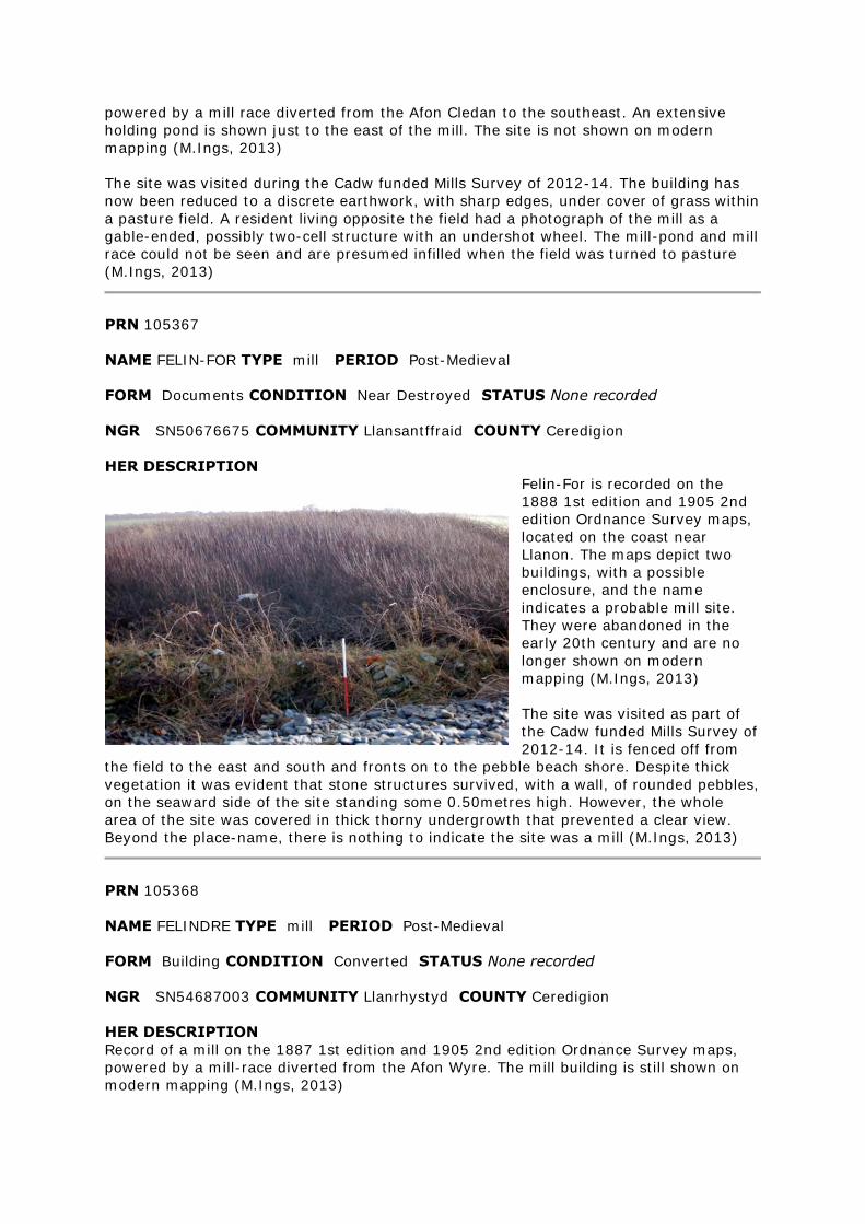
powered by a mill race diverted from the Afon Cledan to the southeast. An extensive
holding pond is shown just to the east of the mill. The site is not shown on modern
mapping (M.Ings, 2013)
The site was visited during the Cadw funded Mills Survey of 2012-14. The building has
now been reduced to a discrete earthwork, with sharp edges, under cover of grass within
a pasture field. A resident living opposite the field had a photograph of the mill as a
gable-ended, possibly two-cell structure with an undershot wheel. The mill-pond and mill
race could not be seen and are presumed infilled when the field was turned to pasture
(M.Ings, 2013)
PRN 105367
NAME FELIN-FOR TYPE mill PERIOD Post-Medieval
FORM Documents CONDITION Near Destroyed STATUS None recorded
NGR SN50676675 COMMUNITY Llansantffraid COUNTY Ceredigion
HER DESCRIPTION
Felin-For is recorded on the
1888 1st edition and 1905 2nd
edition Ordnance Survey maps,
located on the coast near
Llanon. The maps depict two
buildings, with a possible
enclosure, and the name
indicates a probable mill site.
They were abandoned in the
early 20th century and are no
longer shown on modern
mapping (M.Ings, 2013)
The site was visited as part of
the Cadw funded Mills Survey of
2012-14. It is fenced off from
the field to the east and south and fronts on to the pebble beach shore. Despite thick
vegetation it was evident that stone structures survived, with a wall, of rounded pebbles,
on the seaward side of the site standing some 0.50metres high. However, the whole
area of the site was covered in thick thorny undergrowth that prevented a clear view.
Beyond the place-name, there is nothing to indicate the site was a mill (M.Ings, 2013)
PRN 105368
NAME FELINDRE TYPE mill PERIOD Post-Medieval
FORM Building CONDITION Converted STATUS None recorded
NGR SN54687003 COMMUNITY Llanrhystyd COUNTY Ceredigion
HER DESCRIPTION
Record of a mill on the 1887 1st edition and 1905 2nd edition Ordnance Survey maps,
powered by a mill-race diverted from the Afon Wyre. The mill building is still shown on
modern mapping (M.Ings, 2013)
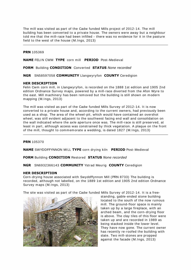
The mill was visited as part of the Cadw funded Mills project of 2012-14. The mill
building has been converted to a private house. The owners were away but a neighbour
told me that the mill-race had been infilled - there was no evidence for it in the pasture
field to the west of the house (M.Ings, 2013)
PRN 105369
NAME FELIN CWM TYPE corn mill PERIOD Post-Medieval
FORM Building CONDITION Converted STATUS None recorded
NGR SN58597058 COMMUNITY Llangwyryfon COUNTY Ceredigion
HER DESCRIPTION
Felin Cwm corn mill, in Llangwyryfon, is recorded on the 1888 1st edition and 1905 2nd
edition Ordnance Survey maps, powered by a mill-race diverted from the Afon Wyre to
the east. Mill machinery has been removed but the building is still shown on modern
mapping (M.Ings, 2013)
The mill was visited as part of the Cadw funded Mills Survey of 2012-14. It is now
converted to a private house and, according to the current owners, had previously been
used as a shop. The area of the wheel-pit, which would have contained an overshot
wheel, was still evident adjacent to the southwest facing end wall and consolidation on
the wall indicated where the axle aperture once was. The mill-race is still preserved, at
least in part, although access was constrained by thick vegetation. A plaque on the front
of the mill, thought to commemorate a wedding, is dated 1827 (M.Ings, 2013)
PRN 105370
NAME SWYDDFFYNNON MILL TYPE corn drying kiln PERIOD Post-Medieval
FORM Building CONDITION Restored STATUS None recorded
NGR SN6932366143 COMMUNITY Ystrad Meurig COUNTY Ceredigion
HER DESCRIPTION
Corn-drying house associated with Swyddffynnon Mill (PRN 8733) The building is
recorded, although not labelled, on the 1889 1st edition and 1905 2nd edition Ordnance
Survey maps (M.Ings, 2013)
The site was visited as part of the Cadw funded Mills Survey of 2012-14. It is a free-
standing, gable-ended stone building
located to the south of the now ruinous
mill. The ground-floor space is mainly
taken up by a large fireplace, with an
arched beam, and the corn-drying floor
is above. The clay tiles of this floor were
taken up and are recorded in 1989 as
being stacked inside the lower level.
They have now gone. The current owner
has recently re-roofed the building with
slate. Two mill-stones are propped
against the facade (M.Ings, 2013)
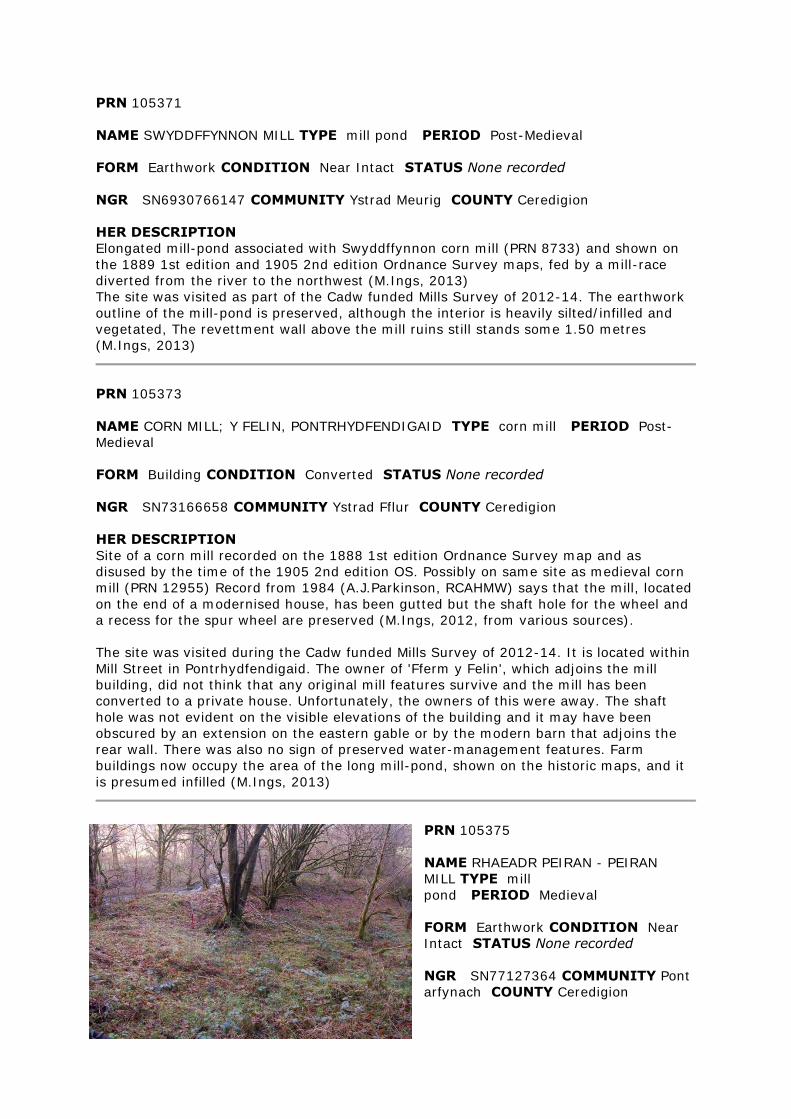
PRN 105371
NAME SWYDDFFYNNON MILL TYPE mill pond PERIOD Post-Medieval
FORM Earthwork CONDITION Near Intact STATUS None recorded
NGR SN6930766147 COMMUNITY Ystrad Meurig COUNTY Ceredigion
HER DESCRIPTION
Elongated mill-pond associated with Swyddffynnon corn mill (PRN 8733) and shown on
the 1889 1st edition and 1905 2nd edition Ordnance Survey maps, fed by a mill-race
diverted from the river to the northwest (M.Ings, 2013)
The site was visited as part of the Cadw funded Mills Survey of 2012-14. The earthwork
outline of the mill-pond is preserved, although the interior is heavily silted/infilled and
vegetated, The revettment wall above the mill ruins still stands some 1.50 metres
(M.Ings, 2013)
PRN 105373
NAME CORN MILL; Y FELIN, PONTRHYDFENDIGAID TYPE corn mill PERIOD Post-
Medieval
FORM Building CONDITION Converted STATUS None recorded
NGR SN73166658 COMMUNITY Ystrad Fflur COUNTY Ceredigion
HER DESCRIPTION
Site of a corn mill recorded on the 1888 1st edition Ordnance Survey map and as
disused by the time of the 1905 2nd edition OS. Possibly on same site as medieval corn
mill (PRN 12955) Record from 1984 (A.J.Parkinson, RCAHMW) says that the mill, located
on the end of a modernised house, has been gutted but the shaft hole for the wheel and
a recess for the spur wheel are preserved (M.Ings, 2012, from various sources).
The site was visited during the Cadw funded Mills Survey of 2012-14. It is located within
Mill Street in Pontrhydfendigaid. The owner of 'Fferm y Felin', which adjoins the mill
building, did not think that any original mill features survive and the mill has been
converted to a private house. Unfortunately, the owners of this were away. The shaft
hole was not evident on the visible elevations of the building and it may have been
obscured by an extension on the eastern gable or by the modern barn that adjoins the
rear wall. There was also no sign of preserved water-management features. Farm
buildings now occupy the area of the long mill-pond, shown on the historic maps, and it
is presumed infilled (M.Ings, 2013)
PRN 105375
NAME RHAEADR PEIRAN - PEIRAN
MILL TYPE mill
pond PERIOD Medieval
FORM Earthwork CONDITION Near
Intact STATUS None recorded
NGR SN77127364 COMMUNITY Pont
arfynach COUNTY Ceredigion
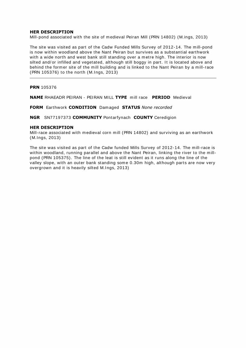
HER DESCRIPTION
Mill-pond associated with the site of medieval Peiran Mill (PRN 14802) (M.ings, 2013)
The site was visited as part of the Cadw Funded Mills Survey of 2012-14. The mill-pond
is now within woodland above the Nant Peiran but survives as a substantial earthwork
with a wide north and west bank still standing over a metre high. The interior is now
silted and/or infilled and vegetated, although still boggy in part. It is located above and
behind the former site of the mill building and is linked to the Nant Peiran by a mill-race
(PRN 105376) to the north (M.Ings, 2013)
PRN 105376
NAME RHAEADR PEIRAN - PEIRAN MILL TYPE mill race PERIOD Medieval
FORM Earthwork CONDITION Damaged STATUS None recorded
NGR SN77197373 COMMUNITY Pontarfynach COUNTY Ceredigion
HER DESCRIPTION
Mill-race associated with medieval corn mill (PRN 14802) and surviving as an earthwork
(M.Ings, 2013)
The site was visited as part of the Cadw funded Mills Survey of 2012-14. The mill-race is
within woodland, running parallel and above the Nant Peiran, linking the river to the mill-
pond (PRN 105375). The line of the leat is still evident as it runs along the line of the
valley slope, with an outer bank standing some 0.30m high, although parts are now very
overgrown and it is heavily silted M.Ings, 2013)
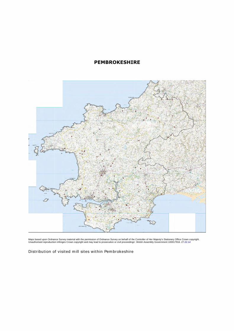
PEMBROKESHIRE
Maps based upon Ordnance Survey material with the permission of Ordnance Survey on behalf of the Controller of Her Majesty's Stationery Office Crown copyright. Unauthorised reproduction infringes Crown copyright and may lead to prosecution or civil proceedings'. Welsh Assembly Government 100017916. 27.02.14
Distribution of visited mill sites within Pembrokeshire
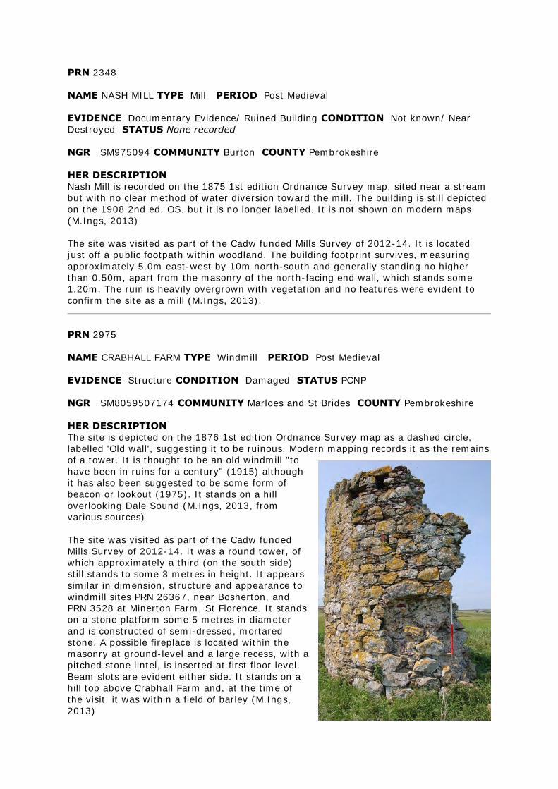
PRN 2348
NAME NASH MILL TYPE Mill PERIOD Post Medieval
EVIDENCE Documentary Evidence/ Ruined Building CONDITION Not known/ Near
Destroyed STATUS None recorded
NGR SM975094 COMMUNITY Burton COUNTY Pembrokeshire
HER DESCRIPTION
Nash Mill is recorded on the 1875 1st edition Ordnance Survey map, sited near a stream
but with no clear method of water diversion toward the mill. The building is still depicted
on the 1908 2nd ed. OS. but it is no longer labelled. It is not shown on modern maps
(M.Ings, 2013)
The site was visited as part of the Cadw funded Mills Survey of 2012-14. It is located
just off a public footpath within woodland. The building footprint survives, measuring
approximately 5.0m east-west by 10m north-south and generally standing no higher
than 0.50m, apart from the masonry of the north-facing end wall, which stands some
1.20m. The ruin is heavily overgrown with vegetation and no features were evident to
confirm the site as a mill (M.Ings, 2013).
PRN 2975
NAME CRABHALL FARM TYPE Windmill PERIOD Post Medieval
EVIDENCE Structure CONDITION Damaged STATUS PCNP
NGR SM8059507174 COMMUNITY Marloes and St Brides COUNTY Pembrokeshire
HER DESCRIPTION
The site is depicted on the 1876 1st edition Ordnance Survey map as a dashed circle,
labelled 'Old wall', suggesting it to be ruinous. Modern mapping records it as the remains
of a tower. It is thought to be an old windmill "to
have been in ruins for a century" (1915) although
it has also been suggested to be some form of
beacon or lookout (1975). It stands on a hill
overlooking Dale Sound (M.Ings, 2013, from
various sources)
The site was visited as part of the Cadw funded
Mills Survey of 2012-14. It was a round tower, of
which approximately a third (on the south side)
still stands to some 3 metres in height. It appears
similar in dimension, structure and appearance to
windmill sites PRN 26367, near Bosherton, and
PRN 3528 at Minerton Farm, St Florence. It stands
on a stone platform some 5 metres in diameter
and is constructed of semi-dressed, mortared
stone. A possible fireplace is located within the
masonry at ground-level and a large recess, with a
pitched stone lintel, is inserted at first floor level.
Beam slots are evident either side. It stands on a
hill top above Crabhall Farm and, at the time of
the visit, it was within a field of barley (M.Ings,
2013)
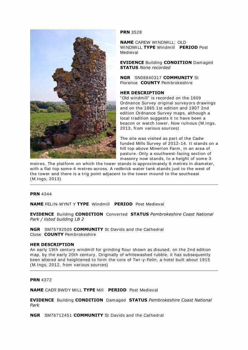
PRN 3528
NAME CAREW WINDMILL; OLD
WINDMILL TYPE Windmill PERIOD Post
Medieval
EVIDENCE Building CONDITION Damaged
STATUS None recorded
NGR SN08840317 COMMUNITY St
Florence COUNTY Pembrokeshire
HER DESCRIPTION
"Old windmill" is recorded on the 1809
Ordnance Survey original surveyors drawings
and on the 1865 1st edition and 1907 2nd
edition Ordnance Survey maps, although a
local tradition suggests it to have been a
beacon or watch tower. Now ruinous (M.Ings,
2013, from various sources)
The site was visited as part of the Cadw
funded Mills Survey of 2012-14. It stands on a
hill top above Minerton Farm, in an area of
pasture. Only a southwest-facing section of
masonry now stands, to a height of some 3
metres. The platform on which the tower stands is approximately 6 metres in diameter,
with a flat top some 4 metres across. A redbrick water tank stands just to the west of
the tower and there is a trig point adjacent to the tower mound to the southeast
(M.Ings, 2013)
PRN 4344
NAME FELIN-WYNT Y TYPE Windmill PERIOD Post Medieval
EVIDENCE Building CONDITION Converted STATUS Pembrokeshire Coast National
Park / listed building LB 2
NGR SM75792509 COMMUNITY St Davids and the Cathedral
Close COUNTY Pembrokeshire
HER DESCRIPTION
An early 19th century windmill for grinding flour shown as disused, on the 2nd edition
map, by the early 20th century. Originally of whitewashed rubble, it has subsequently
been altered and heightened to form the core of Twr-y-Felin, a hotel built about 1915
(M.Ings, 2012, from various sources)
PRN 4372
NAME CAER BWDY MILL TYPE Mill PERIOD Post Medieval
EVIDENCE Building CONDITION Damaged STATUS Pembrokeshire Coast National
Park
NGR SM76712451 COMMUNITY St Davids and the Cathedral
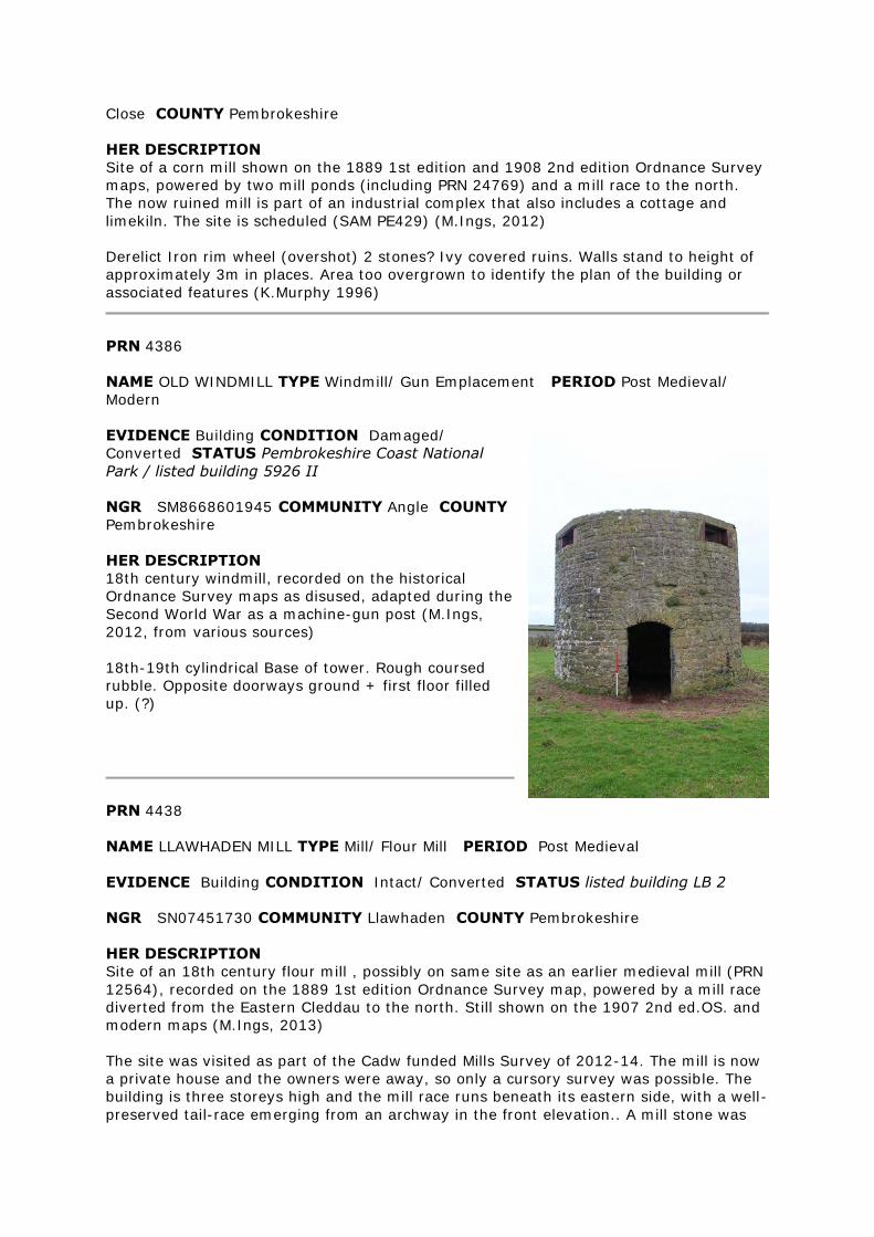
Close COUNTY Pembrokeshire
HER DESCRIPTION
Site of a corn mill shown on the 1889 1st edition and 1908 2nd edition Ordnance Survey
maps, powered by two mill ponds (including PRN 24769) and a mill race to the north.
The now ruined mill is part of an industrial complex that also includes a cottage and
limekiln. The site is scheduled (SAM PE429) (M.Ings, 2012)
Derelict Iron rim wheel (overshot) 2 stones? Ivy covered ruins. Walls stand to height of
approximately 3m in places. Area too overgrown to identify the plan of the building or
associated features (K.Murphy 1996)
PRN 4386
NAME OLD WINDMILL TYPE Windmill/ Gun Emplacement PERIOD Post Medieval/
Modern
EVIDENCE Building CONDITION Damaged/
Converted STATUS Pembrokeshire Coast National
Park / listed building 5926 II
NGR SM8668601945 COMMUNITY Angle COUNTY
Pembrokeshire
HER DESCRIPTION
18th century windmill, recorded on the historical
Ordnance Survey maps as disused, adapted during the
Second World War as a machine-gun post (M.Ings,
2012, from various sources)
18th-19th cylindrical Base of tower. Rough coursed
rubble. Opposite doorways ground + first floor filled
up. (?)
PRN 4438
NAME LLAWHADEN MILL TYPE Mill/ Flour Mill PERIOD Post Medieval
EVIDENCE Building CONDITION Intact/ Converted STATUS listed building LB 2
NGR SN07451730 COMMUNITY Llawhaden COUNTY Pembrokeshire
HER DESCRIPTION
Site of an 18th century flour mill , possibly on same site as an earlier medieval mill (PRN
12564), recorded on the 1889 1st edition Ordnance Survey map, powered by a mill race
diverted from the Eastern Cleddau to the north. Still shown on the 1907 2nd ed.OS. and
modern maps (M.Ings, 2013)
The site was visited as part of the Cadw funded Mills Survey of 2012-14. The mill is now
a private house and the owners were away, so only a cursory survey was possible. The
building is three storeys high and the mill race runs beneath its eastern side, with a well-
preserved tail-race emerging from an archway in the front elevation.. A mill stone was
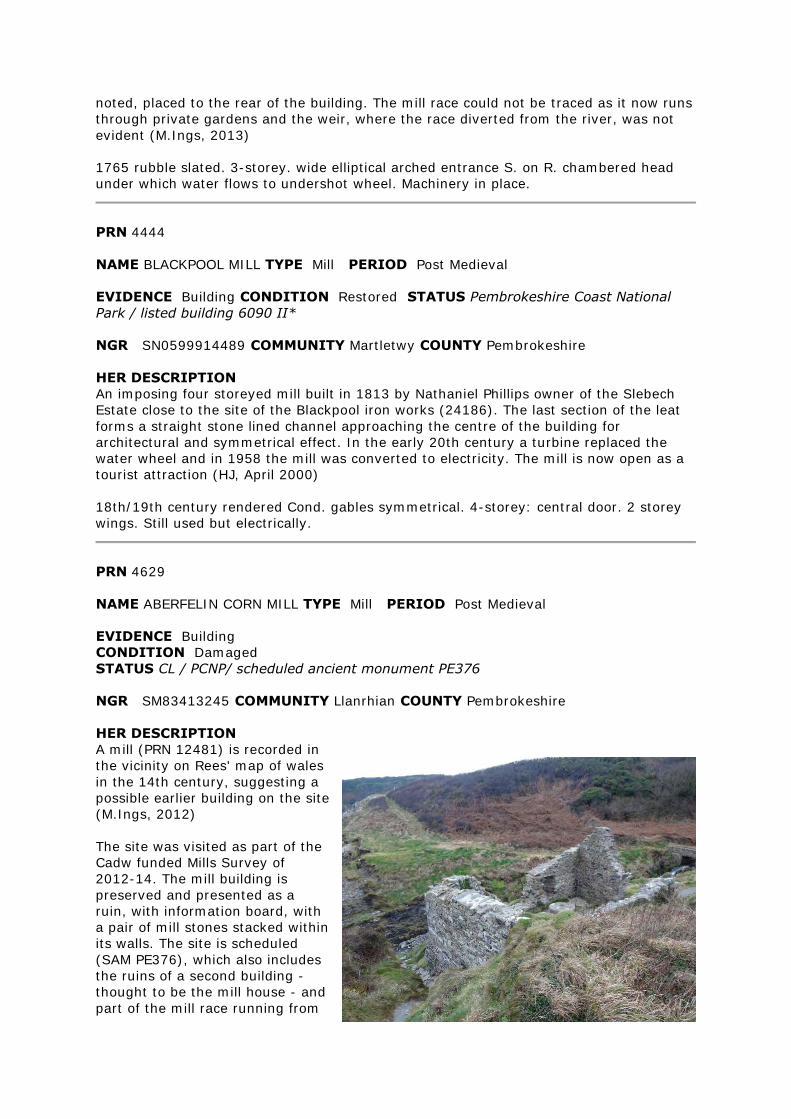
noted, placed to the rear of the building. The mill race could not be traced as it now runs
through private gardens and the weir, where the race diverted from the river, was not
evident (M.Ings, 2013)
1765 rubble slated. 3-storey. wide elliptical arched entrance S. on R. chambered head
under which water flows to undershot wheel. Machinery in place.
PRN 4444
NAME BLACKPOOL MILL TYPE Mill PERIOD Post Medieval
EVIDENCE Building CONDITION Restored STATUS Pembrokeshire Coast National
Park / listed building 6090 II*
NGR SN0599914489 COMMUNITY Martletwy COUNTY Pembrokeshire
HER DESCRIPTION
An imposing four storeyed mill built in 1813 by Nathaniel Phillips owner of the Slebech
Estate close to the site of the Blackpool iron works (24186). The last section of the leat
forms a straight stone lined channel approaching the centre of the building for
architectural and symmetrical effect. In the early 20th century a turbine replaced the
water wheel and in 1958 the mill was converted to electricity. The mill is now open as a
tourist attraction (HJ, April 2000)
18th/19th century rendered Cond. gables symmetrical. 4-storey: central door. 2 storey
wings. Still used but electrically.
PRN 4629
NAME ABERFELIN CORN MILL TYPE Mill PERIOD Post Medieval
EVIDENCE Building
CONDITION Damaged
STATUS CL / PCNP/ scheduled ancient monument PE376
NGR SM83413245 COMMUNITY Llanrhian COUNTY Pembrokeshire
HER DESCRIPTION
A mill (PRN 12481) is recorded in
the vicinity on Rees' map of wales
in the 14th century, suggesting a
possible earlier building on the site
(M.Ings, 2012)
The site was visited as part of the
Cadw funded Mills Survey of
2012-14. The mill building is
preserved and presented as a
ruin, with information board, with
a pair of mill stones stacked within
its walls. The site is scheduled
(SAM PE376), which also includes
the ruins of a second building -
thought to be the mill house - and
part of the mill race running from
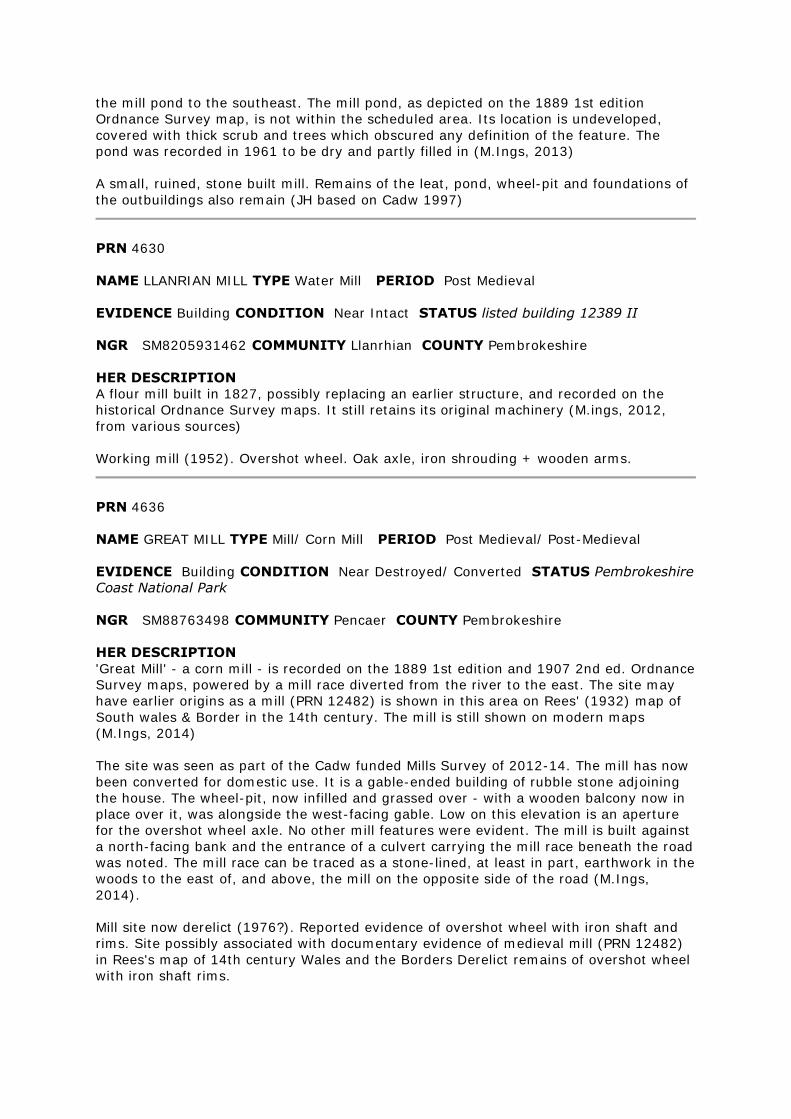
the mill pond to the southeast. The mill pond, as depicted on the 1889 1st edition
Ordnance Survey map, is not within the scheduled area. Its location is undeveloped,
covered with thick scrub and trees which obscured any definition of the feature. The
pond was recorded in 1961 to be dry and partly filled in (M.Ings, 2013)
A small, ruined, stone built mill. Remains of the leat, pond, wheel-pit and foundations of
the outbuildings also remain (JH based on Cadw 1997)
PRN 4630
NAME LLANRIAN MILL TYPE Water Mill PERIOD Post Medieval
EVIDENCE Building CONDITION Near Intact STATUS listed building 12389 II
NGR SM8205931462 COMMUNITY Llanrhian COUNTY Pembrokeshire
HER DESCRIPTION
A flour mill built in 1827, possibly replacing an earlier structure, and recorded on the
historical Ordnance Survey maps. It still retains its original machinery (M.ings, 2012,
from various sources)
Working mill (1952). Overshot wheel. Oak axle, iron shrouding + wooden arms.
PRN 4636
NAME GREAT MILL TYPE Mill/ Corn Mill PERIOD Post Medieval/ Post-Medieval
EVIDENCE Building CONDITION Near Destroyed/ Converted STATUS Pembrokeshire
Coast National Park
NGR SM88763498 COMMUNITY Pencaer COUNTY Pembrokeshire
HER DESCRIPTION
'Great Mill' - a corn mill - is recorded on the 1889 1st edition and 1907 2nd ed. Ordnance
Survey maps, powered by a mill race diverted from the river to the east. The site may
have earlier origins as a mill (PRN 12482) is shown in this area on Rees' (1932) map of
South wales & Border in the 14th century. The mill is still shown on modern maps
(M.Ings, 2014)
The site was seen as part of the Cadw funded Mills Survey of 2012-14. The mill has now
been converted for domestic use. It is a gable-ended building of rubble stone adjoining
the house. The wheel-pit, now infilled and grassed over - with a wooden balcony now in
place over it, was alongside the west-facing gable. Low on this elevation is an aperture
for the overshot wheel axle. No other mill features were evident. The mill is built against
a north-facing bank and the entrance of a culvert carrying the mill race beneath the road
was noted. The mill race can be traced as a stone-lined, at least in part, earthwork in the
woods to the east of, and above, the mill on the opposite side of the road (M.Ings,
2014).
Mill site now derelict (1976?). Reported evidence of overshot wheel with iron shaft and
rims. Site possibly associated with documentary evidence of medieval mill (PRN 12482)
in Rees's map of 14th century Wales and the Borders Derelict remains of overshot wheel
with iron shaft rims.
PRN 4637
NAME ROCH MILL TYPE Mill/ Corn Mill PERIOD Post Medieval
EVIDENCE Building CONDITION Not Known/ Converted STATUS pcnp
NGR SM87362233 COMMUNITY Nolton and Roch COUNTY Pembrokeshire
HER DESCRIPTION
Post-medieval corn mill shown on Ordnance Survey 1st and 2nd editions and 1964 ed OS
maps. It may be the same building as PRN 12475 a medieval mill. (JH 1995 based on SB
1993)
The site was visited as part of the Cadw funded Mills Survey of 2012-14. The mill is
attached to the mill house and the two have now been converted into one, although the
exposed rubblestone of the mill building has been preserved, in contrast to the painted
plaster of the original house. The mill was last in use in the early 1950s .The wheel-pit is
preserved against the gable end, now with a replacement (2007) iron-cast wheel affixed
to the wall. The original iron wheel hub lies nearby. The mill race has now been blocked
off, on neighbouring land, so water from a spring above the house is now used to turn
the wheel. The internal machinery, including the iron pit wheel, and wooden hurst frame,
is preserved behind a glass screen. A date of 1868 is carved onto an upright shaft. A pair
of mill stones are now located in front of the house (M.Ings, 2013).
Overshot wheel. 2 pairs stones. Working in 1952
PRN 4678
NAME FRAINSLAKE MILL TYPE Mill/ Corn Mill PERIOD Medieval/ Post Medieval/ Post-
Medieval
EVIDENCE Building CONDITION Near Destroyed STATUS Pembrokeshire Coast
National Park / SAC / SPA / SSSI
NGR SR89879763 COMMUNITY Castlemartin COUNTY Pembrokeshire
HER DESCRIPTION
Frainslake Mill is recorded on the 1865 1st edition Ordnance Survey map, with an
associated mill pond and dam. Located on the site of an earlier, medieval mill. Disused
by 1908 and now ruinous (M.Ings, from various sources, 2013)
The site was visited as part of the Cadw funded Mills Survey of 2012-14. Unfortunately
access to the mill was not possible as it is located on the Castlemartin Range and all
roads leading to the site were closed by the military (M.Ings, 2013)
Possible 16th/17th century mill site. Buildings and chimney. RJ based on Murphy, K 1993
Frainslake Mill is now partly submerged in the lake. Parts of the building may date to the
16th/17th century, including a 16th century chimney. (JH August 1999 based on
Murphy,K 1993)
PRN 7848
NAME KING'S MILL TYPE Mill/ Corn Mill PERIOD Post Medieval
EVIDENCE Building CONDITION Intact STATUS listed building 16585 II
NGR SR9243898672 COMMUNITY Castlemartin COUNTY Pembrokeshire
HER DESCRIPTION
Site of an 18th-19th century corn mill and house standing on the same site as medieval
mill (PRN 12488), which dates from at least 1591. Mill machinery, in fragmentary
condition, survives within the building and has been recorded by the RCAHMW. The site
is Grade II listed (M.Ings, 2013)
The site was visited as part of the Cadw funded Mills Survey of 2012-14. Unfortunately,
with the owners away it was only possible to gain a quick overview and the interior of
the mill was not seen. The mill building adjoins the house and is intact, built of limestone
rubble and standing three storeys high, slightly higher than the house, and slate roofed.
The windows in the rear elevation were boarded up and a cart-shed stands, at right
angles, against the front elevation. There is a preserved wheel-pit alongside the east-
facing gable, with the iron-frame of an overshot waterwheel still in situ. The mill race
was not seen, obscured by thick vegetation adjacent to the mill and running across fields
to the east that, at the time of the visit, contained two bulls (M.Ings, 2013)
PRN 7970
NAME MILTON TYPE Carding Mill PERIOD Post Medieval
EVIDENCE Building CONDITION Damaged/ Near Destroyed STATUS Pembrokeshire
Coast National Park
NGR SN0395803316 COMMUNITY Carew COUNTY Pembrokeshire
HER DESCRIPTION
A carding mill marked on the 1st edition 25" OS map and located on the south shore of
the upper reaches of Radford Pill. A weir and mill race diverted river water to the mill.
Later maps do not indicate the presence of this mill (RSR April 1999)
The site was visited as part of the Cadw funded Mills Survey of 2012-14. It is located on
the edge of Radford Pill and has now been reduced to an infilled, grassed-over footprint
for use as a picnic area associated with the adjacent caravan park. The walls, of stone
rubble, stand less than one metre high. No features have survived apart from a stone-
lined channel alongside the east-facing elevation, where the mill race channelled water
from the mill pond (PRN 33754), to the south. An information board, located near the
second carding mill (PRN 33753) in Milton, says that there were two carding mills in the
area during the 16th century, suggesting that this post-medieval mill may have earlier
origins (M.Ings, 2014)
PRN 8777
NAME PRENDERGAST MILLS;MILLBANK MILL TYPE Mill/ Paper Mill PERIOD Post
Medieval
EVIDENCE Documentary Evidence/ Ruined Building CONDITION Near Intact/
Damaged STATUS None recorded
NGR SM95391784 COMMUNITY Rudbaxton COUNTY Pembrokeshire
HER DESCRIPTION
A three-storey brick cotton mill built in 1766 and converted to a paper mill by 1791. It
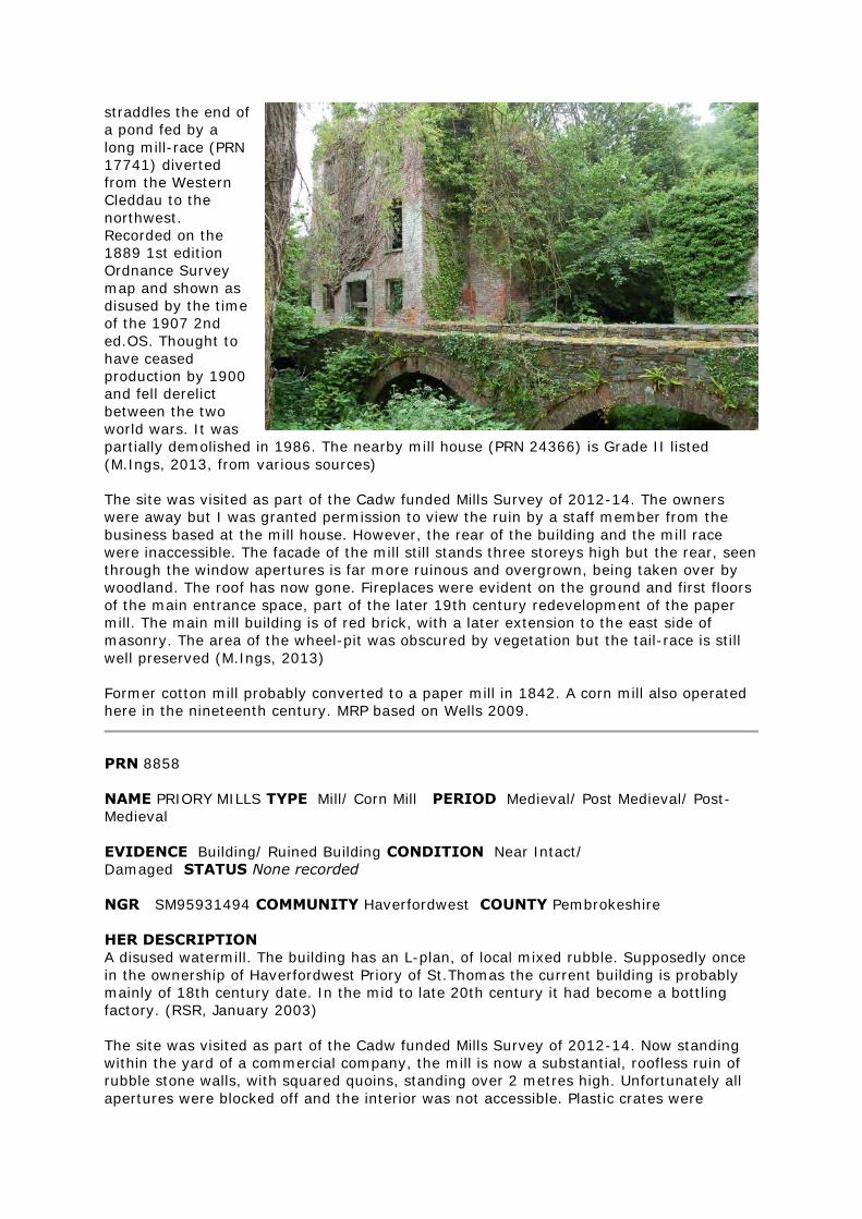
straddles the end of
a pond fed by a
long mill-race (PRN
17741) diverted
from the Western
Cleddau to the
northwest.
Recorded on the
1889 1st edition
Ordnance Survey
map and shown as
disused by the time
of the 1907 2nd
ed.OS. Thought to
have ceased
production by 1900
and fell derelict
between the two
world wars. It was
partially demolished in 1986. The nearby mill house (PRN 24366) is Grade II listed
(M.Ings, 2013, from various sources)
The site was visited as part of the Cadw funded Mills Survey of 2012-14. The owners
were away but I was granted permission to view the ruin by a staff member from the
business based at the mill house. However, the rear of the building and the mill race
were inaccessible. The facade of the mill still stands three storeys high but the rear, seen
through the window apertures is far more ruinous and overgrown, being taken over by
woodland. The roof has now gone. Fireplaces were evident on the ground and first floors
of the main entrance space, part of the later 19th century redevelopment of the paper
mill. The main mill building is of red brick, with a later extension to the east side of
masonry. The area of the wheel-pit was obscured by vegetation but the tail-race is still
well preserved (M.Ings, 2013)
Former cotton mill probably converted to a paper mill in 1842. A corn mill also operated
here in the nineteenth century. MRP based on Wells 2009.
PRN 8858
NAME PRIORY MILLS TYPE Mill/ Corn Mill PERIOD Medieval/ Post Medieval/ Post-
Medieval
EVIDENCE Building/ Ruined Building CONDITION Near Intact/
Damaged STATUS None recorded
NGR SM95931494 COMMUNITY Haverfordwest COUNTY Pembrokeshire
HER DESCRIPTION
A disused watermill. The building has an L-plan, of local mixed rubble. Supposedly once
in the ownership of Haverfordwest Priory of St.Thomas the current building is probably
mainly of 18th century date. In the mid to late 20th century it had become a bottling
factory. (RSR, January 2003)
The site was visited as part of the Cadw funded Mills Survey of 2012-14. Now standing
within the yard of a commercial company, the mill is now a substantial, roofless ruin of
rubble stone walls, with squared quoins, standing over 2 metres high. Unfortunately all
apertures were blocked off and the interior was not accessible. Plastic crates were
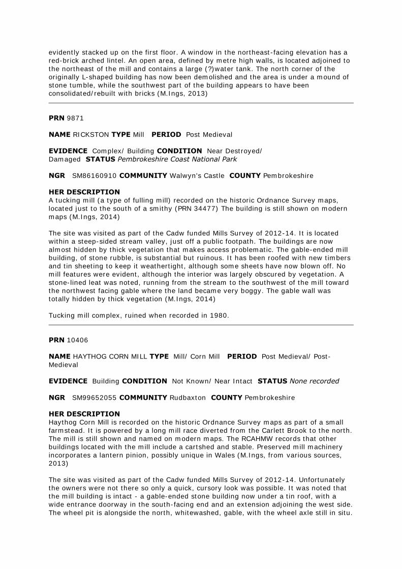
evidently stacked up on the first floor. A window in the northeast-facing elevation has a
red-brick arched lintel. An open area, defined by metre high walls, is located adjoined to
the northeast of the mill and contains a large (?)water tank. The north corner of the
originally L-shaped building has now been demolished and the area is under a mound of
stone tumble, while the southwest part of the building appears to have been
consolidated/rebuilt with bricks (M.Ings, 2013)
PRN 9871
NAME RICKSTON TYPE Mill PERIOD Post Medieval
EVIDENCE Complex/ Building CONDITION Near Destroyed/
Damaged STATUS Pembrokeshire Coast National Park
NGR SM86160910 COMMUNITY Walwyn's Castle COUNTY Pembrokeshire
HER DESCRIPTION
A tucking mill (a type of fulling mill) recorded on the historic Ordnance Survey maps,
located just to the south of a smithy (PRN 34477) The building is still shown on modern
maps (M.Ings, 2014)
The site was visited as part of the Cadw funded Mills Survey of 2012-14. It is located
within a steep-sided stream valley, just off a public footpath. The buildings are now
almost hidden by thick vegetation that makes access problematic. The gable-ended mill
building, of stone rubble, is substantial but ruinous. It has been roofed with new timbers
and tin sheeting to keep it weathertight, although some sheets have now blown off. No
mill features were evident, although the interior was largely obscured by vegetation. A
stone-lined leat was noted, running from the stream to the southwest of the mill toward
the northwest facing gable where the land became very boggy. The gable wall was
totally hidden by thick vegetation (M.Ings, 2014)
Tucking mill complex, ruined when recorded in 1980.
PRN 10406
NAME HAYTHOG CORN MILL TYPE Mill/ Corn Mill PERIOD Post Medieval/ Post-
Medieval
EVIDENCE Building CONDITION Not Known/ Near Intact STATUS None recorded
NGR SM99652055 COMMUNITY Rudbaxton COUNTY Pembrokeshire
HER DESCRIPTION
Haythog Corn Mill is recorded on the historic Ordnance Survey maps as part of a small
farmstead. It is powered by a long mill race diverted from the Carlett Brook to the north.
The mill is still shown and named on modern maps. The RCAHMW records that other
buildings located with the mill include a cartshed and stable. Preserved mill machinery
incorporates a lantern pinion, possibly unique in Wales (M.Ings, from various sources,
2013)
The site was visited as part of the Cadw funded Mills Survey of 2012-14. Unfortunately
the owners were not there so only a quick, cursory look was possible. It was noted that
the mill building is intact - a gable-ended stone building now under a tin roof, with a
wide entrance doorway in the south-facing end and an extension adjoining the west side.
The wheel pit is alongside the north, whitewashed, gable, with the wheel axle still in situ.
Mill machinery, including the hurst frame and axle wheel, are preserved but were not
closely inspected. Likewise, the state of preservation of the mill race was not seen
(M.Ings, 2013)
PRN 12466
NAME MULLOCK MILL TYPE Water Mill PERIOD Medieval
EVIDENCE Documentary Evidence CONDITION Not known STATUS Pembrokeshire
Coast National Park
NGR SM812087 COMMUNITY St Ishmael's COUNTY Pembrokeshire
HER DESCRIPTION
A post-medieval mill (PRN 16054) is recorded close to this location. It may stand on the
same site as a mill recorded on the Rees map (M.Ings, 2013)
A medieval mill in this location is suggested by Rees' map, which purports to show Wales
in the fourteenth century (R.J, 2004).
PRN 12468
NAME GOOSE GREEN TYPE Water Mill/ Dwelling PERIOD Medieval/ Post-Medieval
EVIDENCE Documentary Evidence/ Ruined Building CONDITION Not known/
Damaged STATUS Pembrokeshire Coast National Park
NGR SM83130669 COMMUNITY St Ishmael's COUNTY Pembrokeshire
HER DESCRIPTION
Site of a mill shown on Rees' map (1932) of Wales & Border in the 14th century.
Location uncertain. 'Goosegreen' is the name of a building depicted on the historic
Ordnance Survey maps, to the south of St Ishmael's, although it is not identified as a
mill (M.Ings, 2013).
The site of 'Goosegreen' was visited as part of the Cadw funded Mills Survey of 2012-13
to ascertain whether or not it was a mill. The building, built into the steep slope above a
stream, is now ruinous and very overgrown. The gable ends of the building still stand to
approximate full height but the facade has largely collapsed. The interior was obscured
by thick vegetation. There was nothing to denote the building as a mill. It is set on a
building platform, beneath which are two voids of uncertain use. There is an outbuilding,
also now ruinous, to the west of the house (M.Ings, 2013)
A medieval mill in this location is suggested by Rees' map, which purports to show Wales
in the fourteenth century (MM 2004) Identified from documentary sources (RJ 2004)
PRN 12470
NAME ROSE MOOR; SYKE MILL TYPE Water Mill PERIOD Medieval
EVIDENCE Documentary Evidence CONDITION Not known STATUS Pembrokeshire
Coast National Park
NGR SM873109 COMMUNITY Walwyn's Castle COUNTY Pembrokeshire
HER DESCRIPTION
A medieval mill in this location is suggested by Rees' map, which purports to show Wales
in the fourteenth century (MM 2004) Possibly associated with 'Syke Mill' (PRN 106006)
shown at this location on the 1875 1st edition Ordnance Survey map (M.Ings, 2013)
Identified from documentary sources (RJ 2004)
PRN 12475
NAME BRANDY BROOK WATER MILL TYPE Water Mill PERIOD Medieval
EVIDENCE Documentary Evidence CONDITION Not known STATUS pcnp
NGR SM874223 COMMUNITY Nolton and Roch COUNTY Pembrokeshire
HER DESCRIPTION
A medieval water mill shown on Rees map (1932) and noted by BG Charles. Associated
with PRN 4637 the post medieval mill, the two may be the same. (JH 1995 based on SB
1993)
PRN 12476
NAME OWENSTON TYPE Water Mill PERIOD Medieval
EVIDENCE Documentary Evidence CONDITION Not known STATUS pcnp
NGR SM873235 COMMUNITY Brawdy COUNTY Pembrokeshire
HER DESCRIPTION
Site of a watermill recorded on Rees' (1932) map showing South wales & Border in the
14th century. Location now uncertain. Possibly on the same site as post-medieval 'Old
Mill' (PRN 17957) (M.Ings, 2014)
PRN 12477
NAME BRAWDY TYPE Water Mill PERIOD Medieval
EVIDENCE Documentary Evidence CONDITION Not known STATUS pcnp
NGR SM865226 COMMUNITY Brawdy COUNTY Pembrokeshire
HER DESCRIPTION
Site of a water mill recorded on Rees' map (1932) of South Wales & Border in the 14th
century. Location uncertain but possibly the same site as a post-medieval corn mill (PRN
17961), shown on historic Ordnance Survey maps (M.Ings, 2013)
PRN 12479
NAME LOWER SOLVA TYPE Water Mill PERIOD Medieval
EVIDENCE Documentary Evidence CONDITION Not known STATUS Pembrokeshire
Coast National Park
NGR SM808245 COMMUNITY Solva COUNTY Pembrokeshire
HER DESCRIPTION
A medieval mill in this location is suggested by Rees' (1932) map, which purports to
show Wales in the fourteenth century (MM 2004) Identified from documentary sources.
(RJ 2004)
PRN 12481
NAME ABER-FELIN TYPE Water Mill PERIOD Medieval
EVIDENCE Documentary Evidence CONDITION Near
Destroyed STATUS Pembrokeshire Coast National Park
NGR SM83413245 COMMUNITY Llanrhian COUNTY Pembrokeshire
HER DESCRIPTION
There appears to be a continuation of use of the medieval site of Aber-felin mill, with
Aberfelin corn mill (PRN 4629), being built here in the 18th century (M.Ings, 2012).
A medieval mill in this location is suggested by Rees' map, which purports to show Wales
in the fourteenth century (MM, 2004) Identified from documentary sources. (RJ 2004)
PRN 12482
NAME GREAT MILL TYPE Water Mill PERIOD Medieval
EVIDENCE Documentary Evidence CONDITION Not known STATUS Pembrokeshire
Coast National Park
NGR SM888349 COMMUNITY Pencaer COUNTY Pembrokeshire
HER DESCRIPTION
Potentially on same site as post-medieval Great Mill (PRN 4636) (M.Ings, 2014)
A medieval mill in this location is suggested by Rees' map, which purports to show Wales
in the fourteenth century (MM 2004) Identified from documentary sources. (RJ 2004)
PRN 12484
NAME FELIN-VELINDRE TYPE Water Mill PERIOD Medieval
EVIDENCE Documentary Evidence CONDITION Near
Destroyed STATUS Pembrokeshire Coast National Park
NGR SM894361 COMMUNITY Pencaer COUNTY Pembrokeshire
HER DESCRIPTION
A medieval mill in this location is suggested by Rees' map, which purports to show Wales
in the fourteenth century (MM, 2004)
There appears to be continuation of use at the site, with a corn mill (PRN 59160) built
here in 1798 (M.Ings, 2012) Identified from documentary sources (RJ, 2004)
PRN 12488
NAME KING'S MILL TYPE Water Mill PERIOD Medieval
EVIDENCE Documentary Evidence/ Ruined Building CONDITION Not known/
Damaged STATUS None recorded
NGR SR924987 COMMUNITY Castlemartin COUNTY Pembrokeshire
HER DESCRIPTION
Site of a watermill since at least 1591 believed to be on the same location as post-
medieval corn mill (PRN 7848) (M.Ings, 2013)
Kings Mill is a former medieval water driven corn mill. The extant ruins at the site
comprise an L shaped range of buildings and a further rectangular building to its NE. The
standing ruins are of a 19th century farmstead established at the site which may have
incorporated former ancillary buildings for the mill such as storage or workshops. Below
ground archaeological remains of both the farmstead and earlier features associate with
the mill may survive. The whole complex is medieval in origin with earliest known
reference being a mention in a land grant in 1591. The main mill buildings (PRN 7848)
and the farmhouse now called Corn Mill House (PRN 59432) are both Listed and occupied
buildings lying in the east of the complex. The 19th century layout is clearly shown on
the 2nd edition Ordnance Survey Map (1907). Recent aerial photographs (Next
Perspectives 2009) show the buildings as roofless but standing to full height. (HP, 2013)
PRN 12497
NAME LLANGWM TYPE Water Mill PERIOD Medieval
EVIDENCE Documentary Evidence CONDITION Not known STATUS None recorded
NGR SM989094 COMMUNITY Llangwm and Hook COUNTY Pembrokeshire
HER DESCRIPTION
A water mill marked on William Rees' 1932 map of South Wales and the Border in the
fourteenth century. It is in a similar location to the grist mill (PRN 15223). (RSR
December 2002).
PRN 12506
NAME PELCOMB TYPE Water Mill PERIOD Medieval
EVIDENCE Documentary Evidence CONDITION Not known STATUS None recorded
NGR SM931172 COMMUNITY Haverfordwest COUNTY Pembrokeshire
HER DESCRIPTION
The site of a mill suggested by Rees's (1932) map of 14th century Wales. Pelcomb is not
named on the historic Ordnance Survey maps (M.Ings, 2012)
The location of Pelcomb mill is uncertain. The post-medieval Cuckoo Mill (PRN 17746) is
in the vicinity and it is possible that Pelcomb was an earlier mill on this site (M.Ings,
2012)
PRN 12512
NAME CAMROSE TYPE Water Mill PERIOD Medieval
EVIDENCE Documentary Evidence CONDITION Near Destroyed STATUS None
recorded
NGR SM928199 COMMUNITY Camrose COUNTY Pembrokeshire
HER DESCRIPTION
Possible site of a water mill recorded on Rees' (1932) map of South Wales & Border in
the 14th century (M.Ings, 2012).
It is possible that the 19th century mill site named Camrose (PRN 17737) stands on the
same site and could incorporate medieval fabric within its construction (M.Ings, 2012)
PRN 12517
NAME WOLFSDALE TYPE Water Mill PERIOD Medieval
EVIDENCE Documentary Evidence CONDITION Not known STATUS None recorded
NGR SM929214 COMMUNITY Camrose COUNTY Pembrokeshire
HER DESCRIPTION
Record of a medieval water mill on Rees' (1932) map of South Wales & Border in the
14th century. Location now uncertain, possibly on same site as post-medieval Wolfsdale
corn mill (PRN 17695) recorded on the historic Ordnance Survey maps (M.Ings, 2014)
PRN 12518
NAME LEWESTON TYPE Water Mill PERIOD Medieval
EVIDENCE Documentary Evidence CONDITION Not known STATUS None recorded
NGR SM942222 COMMUNITY Camrose COUNTY Pembrokeshire
HER DESCRIPTION
Record of a medieval water mill on Rees' map (1932) of Wales & the Border in the 14th
century. Post-medieval mill (PRN 17691) is located in the vicinity and may occupy the
same site (M.Ings, 2013)
PRN 12522
NAME WOOD END TYPE Water Mill PERIOD Medieval
EVIDENCE Documentary Evidence CONDITION Not known STATUS None recorded
NGR SM974241 COMMUNITY Spittal COUNTY Pembrokeshire
HER DESCRIPTION
Site of a mill recorded by Rees (1932) on his map of Wales in the 14th century. Possible
location of the mill is uncertain but it could predate the Spittal corn mill (PRN 17724)
(M.Ings, 2012)
PRN 12523
NAME STONEHALL MILLS TYPE Water Mill PERIOD Medieval
EVIDENCE Documentary Evidence CONDITION Not known STATUS None recorded
NGR SM929277 COMMUNITY Hayscastle COUNTY Pembrokeshire
HER DESCRIPTION
Site of a watermill recorded on Rees' (1932) map of South Wales & Border in the 14th
century. Location uncertain, possibly on same site as post-medieval Stonehall Mills (PRN
17629) (M.Ings, 2014)
Two mills indicated.
PRN 12554
NAME LOVESTON MILL TYPE Corn Mill PERIOD Medieval/ Post-Medieval
EVIDENCE Documentary Evidence/ Building CONDITION Not known/
Converted STATUS None recorded
NGR SN087082 COMMUNITY Jeffreyston COUNTY Pembrokeshire
HER DESCRIPTION
Site, of uncertain location, of a medieval mill shown on Rees' (1932) map of South Wales
& Border in the 14th century. Loveston Corn mill is recorded in the same area on the
historic Ordnance Survey maps and it is possible that this had medieval origins. The
building is still shown on modern maps (M.Ings, 2013)
The site was visited as part of the Cadw funded Mills Survey of 2012-14. The building is
L -shaped, now comprising the farmhouse, aligned east-west, with an adjoining
outbuilding, against which stood a mill stone. Originally the footprint of the farmhouse
included the mill house adjoining, to the east, the mill. The east-facing gable wall of the
farmhouse has been largely rebuilt with breezeblocks, but some original stonework
survives, low in the elevation, and it is here that the waterwheel would have been
affixed. The mill race still runs alongside this wall, having been diverted from Loveston
Lake to the north. It is now lined, at least in part, with concrete. The tail race back to the
stream to the south is also preserved as a distinct earthwork (M.Ings, 2013)
Located in the commote of coed Rhath. Arch Camb 1981
PRN 12560
NAME BLACKPOOL MILL TYPE Water Mill PERIOD Medieval
EVIDENCE Documentary Evidence CONDITION Near
Destroyed STATUS Pembrokeshire Coast National Park
NGR SN060145 COMMUNITY Martletwy COUNTY Pembrokeshire
HER DESCRIPTION
Medieval mill, a possession of the Commandery of Slebech (PRN 3592) replaced by a
large early 19th century mill (PRN 4444) (HJ, April 2000)
PRN 12564
NAME ROGERSHOOK TYPE Fulling Mill PERIOD Medieval
EVIDENCE Documentary Evidence CONDITION Not known STATUS None recorded
NGR SN074173 COMMUNITY Llawhaden COUNTY Pembrokeshire
HER DESCRIPTION
Documentary records of a medieval watermill, of uncertain location although possibly
occupying the same site as post-medieval flour mill (PRN 4438) (M.Ings 2013)
The bishop of St Davids held a fulling-mill worth 20s a year at Llawhaden in 1326. (Black
Book of St David's).
PRN 12573
NAME GILFACH-LLOI TYPE Water Mill PERIOD Medieval
EVIDENCE Documentary Evidence CONDITION Near Destroyed STATUS None
recorded
NGR SN088275 COMMUNITY Maenclochog COUNTY Pembrokeshire
HER DESCRIPTION
Site of a water mill shown on Rees' (1932) map of Wales in the 14th century. The
location is now uncertain, possibly it stood on the site of the post-medieval Maenclochog
Mill (PRN 20859) (M.Ings, 2012)
PRN 12575
NAME CASTELL MILL TYPE Water Mill PERIOD Medieval
EVIDENCE Documentary Evidence CONDITION Near
Destroyed STATUS Pembrokeshire Coast National Park
NGR SN056389 COMMUNITY Newport COUNTY Pembrokeshire
HER DESCRIPTION
A medieval mill in this location is suggested by Rees' map, which purports to show Wales
in the fourteenth century (MM 2004)
Identified from documentary sources. (RJ 2004) It is possible that the medieval mill
stood on the same site occupied by the late 18th or early 19th century Castle Mill (PRN
18698). If so, fabric from the mill may have been incorporated into the later building
(M.Ings, 2012)
PRN 12576
NAME NEW MILL TYPE Water Mill PERIOD Medieval
EVIDENCE Documentary Evidence CONDITION Near
Destroyed STATUS Pembrokeshire Coast National Park
NGR SN069392 COMMUNITY Newport COUNTY Pembrokeshire
HER DESCRIPTION
A medieval mill in this location is suggested by Rees' map, which purports to show Wales
in the fourteenth century (MM 2004)
The location of the mill is uncertain. Possibly it stood on the site of the 19th century
Llwyngwair Mill (PRN 58770) and, if so, medieval fabric is potentially incorporated into
the later building (M.Ings, 2012) Identified from documentary sources (RJ 2004)
PRN 12584
NAME MILL HOUSE THE TYPE Water Mill PERIOD Medieval
EVIDENCE Documentary Evidence CONDITION Not known STATUS Pembrokeshire
Coast National Park
NGR SN171073 COMMUNITY Amroth COUNTY Pembrokeshire
HER DESCRIPTION
Possibly on same site as post-medieval Amroth Mill (PRN 18816) recorded on the 1889
1st edition Ordnance Survey map (M.Ings, 2014)
A medieval mill in this location is suggested by Rees' map, which purports to show Wales
in the fourteenth century (MM 2004) Identified from documentary sources. RJ 2004
PRN 12606
NAME CWM PLYSGOG; FELIN BAN TYPE Fulling Mill PERIOD Post-Medieval
EVIDENCE Documentary Evidence CONDITION Not known STATUS None recorded
NGR SN1933743139 COMMUNITY Cilgerran COUNTY Pembrokeshire
HER DESCRIPTION
Post-medieval Felin Ban, a Fulling mill recorded on the historic Ordnance Survey maps
on the bank of the Afon Ffysgog. Shown on modern maps to now be ruinous It is
possibly on the same site as a medieval mill (PRN 12933) shown on Rees' (1932) map of
South Wales and Border in the 14th century (M.Ings, 2013)
The site was visited as part of the Cadw funded Mills Survey of 2012-14. Unfortunately
the mill was not seen as access proved impossible - the area of the stream where the
mill is located is fenced off under private ownership and permission for access could not
be found (M.Ings, 2013)
PRN 12631
NAME FELIN-FACH TYPE Water Mill PERIOD Medieval
EVIDENCE Documentary Evidence CONDITION Not known STATUS None recorded
NGR SN214369 COMMUNITY Boncath COUNTY Pembrokeshire
HER DESCRIPTION
Record of a water mill on Rees' (1932) map of South Wales & Border in the 14th
century. Location is uncertain but post-medieval mill, Felin Fach (PRN 15460) is located
close-by and may be on the same site (M.Ings, 2013)
PRN 12933
NAME CILGERRAN MILL TYPE Fulling Mill PERIOD Medieval
EVIDENCE Documentary Evidence CONDITION Not known STATUS None recorded
NGR SN194431 COMMUNITY Cilgerran COUNTY Pembrokeshire
HER DESCRIPTION
Site of a fulling mill shown on Rees' (1932) map of South Wales and Border in the 14th
century. Exact location unknown. Possibly on same site as post medieval mill (PRN
12606) recorded on historic Ordnance Survey maps (M.Ings, 2013)
PRN 15171
NAME BRYNBERIAN MILL; MELIN BRYN-Y-BERION TYPE Corn Mill PERIOD Post
Medieval
EVIDENCE Building CONDITION Intact STATUS Pembrokeshire Coast National Park /
listed building 13062 II
NGR SN1054335184 COMMUNITY Eglwyswrw COUNTY Pembrokeshire
HER DESCRIPTION
Melin Bryn-y-berion is a corn mill recorded the 1842 Meline tithe map and on the historic
Ordnance Survey maps, powered by a mill stream diverted from the river to the south.
The building is Grade II listed as a 'complete rural corn mill of regional character and
with a malt-drying kiln' Named 'Felin Bryn' on modern maps (M.Ings, 2014)
The site was visited as part of the Cadw funded Mills Survey of 2012-14. The owners
were away so only a cursory look at the mill building was possible. It is of rubble stone
with a half-hipped slate roof, adjoining a kiln house to the east. There is an overshot
waterwheel attached to the west-facing elevation. The mill stream (PRN 105991)
survives as a well-defined earthwork, complete with the sluice gate marked on the 2nd
edition OS. map. The weir on the river is also preserved, with an elongated stone placed
to divert water into the mill stream (M.Ings, 2014)
The 19th century water mill is constructed out of rubble stone and capped with a slate
roof. Two sections are built into the earth bank, with loft range and over shot water
wheel. At time of listing the mill contained wooden mill machinery. (RJ 2003 from Cadw
listing schedule)
PRN 15223
NAME GRIST MILL TYPE Mill PERIOD Post Medieval
EVIDENCE Building/ Ruined Building CONDITION Not Known/
Damaged STATUS None recorded
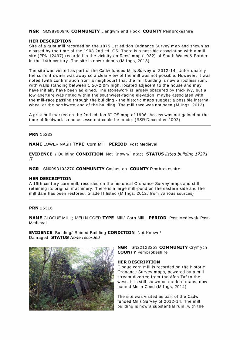
NGR SM98900940 COMMUNITY Llangwm and Hook COUNTY Pembrokeshire
HER DESCRIPTION
Site of a grist mill recorded on the 1875 1st edition Ordnance Survey map and shown as
disused by the time of the 1908 2nd ed. OS. There is a possible association with a mill
site (PRN 12497) recorded in the vicinity on Rees' map (1932) of South Wales & Border
in the 14th century. The site is now ruinous (M.Ings, 2013)
The site was visited as part of the Cadw funded Mills Survey of 2012-14. Unfortunately
the current owner was away so a clear view of the mill was not possible. However, it was
noted (with confirmation from a neighbour) that the mill building is now a roofless ruin,
with walls standing between 1.50-2.0m high, located adjacent to the house and may
have initially have been adjoined. The stonework is largely obscured by thick ivy, but a
low aperture was noted within the southwest-facing elevation, maybe associated with
the mill-race passing through the building - the historic maps suggest a possible internal
wheel at the northwest end of the building, The mill race was not seen (M.Ings, 2013).
A grist mill marked on the 2nd edition 6" OS map of 1906. Access was not gained at the
time of fieldwork so no assessment could be made. (RSR December 2002).
PRN 15233
NAME LOWER NASH TYPE Corn Mill PERIOD Post Medieval
EVIDENCE / Building CONDITION Not Known/ Intact STATUS listed building 17271
II
NGR SN0093103270 COMMUNITY Cosheston COUNTY Pembrokeshire
HER DESCRIPTION
A 19th century corn mill, recorded on the historical Ordnance Survey maps and still
retaining its original machinery. There is a large mill-pond on the eastern side and the
mill dam has been restored. Grade II listed (M.Ings, 2012, from various sources)
PRN 15316
NAME GLOGUE MILL; MELIN COED TYPE Mill/ Corn Mill PERIOD Post Medieval/ Post-
Medieval
EVIDENCE Building/ Ruined Building CONDITION Not Known/
Damaged STATUS None recorded
NGR SN22123253 COMMUNITY Crymych
COUNTY Pembrokeshire
HER DESCRIPTION
Glogue corn mill is recorded on the historic
Ordnance Survey maps, powered by a mill
stream diverted from the Afon Taf to the
west. It is still shown on modern maps, now
named Melin Coed (M.Ings, 2014)
The site was visited as part of the Cadw
funded Mills Survey of 2012-14. The mill
building is now a substantial ruin, with the
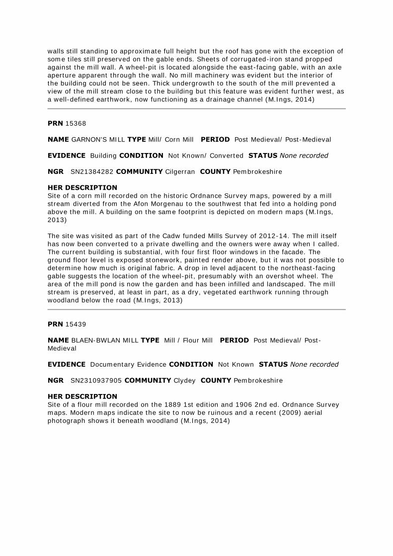
walls still standing to approximate full height but the roof has gone with the exception of
some tiles still preserved on the gable ends. Sheets of corrugated-iron stand propped
against the mill wall. A wheel-pit is located alongside the east-facing gable, with an axle
aperture apparent through the wall. No mill machinery was evident but the interior of
the building could not be seen. Thick undergrowth to the south of the mill prevented a
view of the mill stream close to the building but this feature was evident further west, as
a well-defined earthwork, now functioning as a drainage channel (M.Ings, 2014)
PRN 15368
NAME GARNON'S MILL TYPE Mill/ Corn Mill PERIOD Post Medieval/ Post-Medieval
EVIDENCE Building CONDITION Not Known/ Converted STATUS None recorded
NGR SN21384282 COMMUNITY Cilgerran COUNTY Pembrokeshire
HER DESCRIPTION
Site of a corn mill recorded on the historic Ordnance Survey maps, powered by a mill
stream diverted from the Afon Morgenau to the southwest that fed into a holding pond
above the mill. A building on the same footprint is depicted on modern maps (M.Ings,
2013)
The site was visited as part of the Cadw funded Mills Survey of 2012-14. The mill itself
has now been converted to a private dwelling and the owners were away when I called.
The current building is substantial, with four first floor windows in the facade. The
ground floor level is exposed stonework, painted render above, but it was not possible to
determine how much is original fabric. A drop in level adjacent to the northeast-facing
gable suggests the location of the wheel-pit, presumably with an overshot wheel. The
area of the mill pond is now the garden and has been infilled and landscaped. The mill
stream is preserved, at least in part, as a dry, vegetated earthwork running through
woodland below the road (M.Ings, 2013)
PRN 15439
NAME BLAEN-BWLAN MILL TYPE Mill / Flour Mill PERIOD Post Medieval/ Post-
Medieval
EVIDENCE Documentary Evidence CONDITION Not Known STATUS None recorded
NGR SN2310937905 COMMUNITY Clydey COUNTY Pembrokeshire
HER DESCRIPTION
Site of a flour mill recorded on the 1889 1st edition and 1906 2nd ed. Ordnance Survey
maps. Modern maps indicate the site to now be ruinous and a recent (2009) aerial
photograph shows it beneath woodland (M.Ings, 2014)
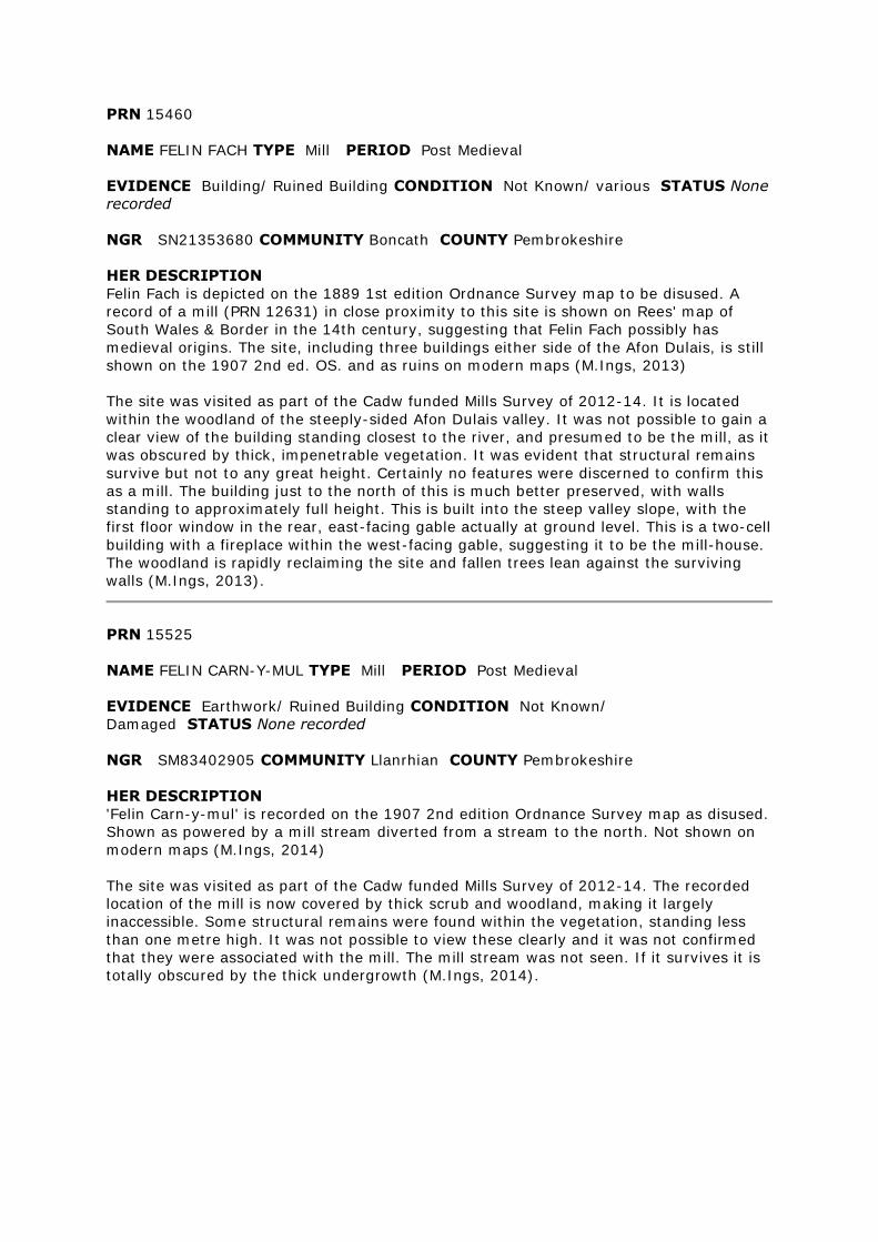
PRN 15460
NAME FELIN FACH TYPE Mill PERIOD Post Medieval
EVIDENCE Building/ Ruined Building CONDITION Not Known/ various STATUS None
recorded
NGR SN21353680 COMMUNITY Boncath COUNTY Pembrokeshire
HER DESCRIPTION
Felin Fach is depicted on the 1889 1st edition Ordnance Survey map to be disused. A
record of a mill (PRN 12631) in close proximity to this site is shown on Rees' map of
South Wales & Border in the 14th century, suggesting that Felin Fach possibly has
medieval origins. The site, including three buildings either side of the Afon Dulais, is still
shown on the 1907 2nd ed. OS. and as ruins on modern maps (M.Ings, 2013)
The site was visited as part of the Cadw funded Mills Survey of 2012-14. It is located
within the woodland of the steeply-sided Afon Dulais valley. It was not possible to gain a
clear view of the building standing closest to the river, and presumed to be the mill, as it
was obscured by thick, impenetrable vegetation. It was evident that structural remains
survive but not to any great height. Certainly no features were discerned to confirm this
as a mill. The building just to the north of this is much better preserved, with walls
standing to approximately full height. This is built into the steep valley slope, with the
first floor window in the rear, east-facing gable actually at ground level. This is a two-cell
building with a fireplace within the west-facing gable, suggesting it to be the mill-house.
The woodland is rapidly reclaiming the site and fallen trees lean against the surviving
walls (M.Ings, 2013).
PRN 15525
NAME FELIN CARN-Y-MUL TYPE Mill PERIOD Post Medieval
EVIDENCE Earthwork/ Ruined Building CONDITION Not Known/
Damaged STATUS None recorded
NGR SM83402905 COMMUNITY Llanrhian COUNTY Pembrokeshire
HER DESCRIPTION
'Felin Carn-y-mul' is recorded on the 1907 2nd edition Ordnance Survey map as disused.
Shown as powered by a mill stream diverted from a stream to the north. Not shown on
modern maps (M.Ings, 2014)
The site was visited as part of the Cadw funded Mills Survey of 2012-14. The recorded
location of the mill is now covered by thick scrub and woodland, making it largely
inaccessible. Some structural remains were found within the vegetation, standing less
than one metre high. It was not possible to view these clearly and it was not confirmed
that they were associated with the mill. The mill stream was not seen. If it survives it is
totally obscured by the thick undergrowth (M.Ings, 2014).
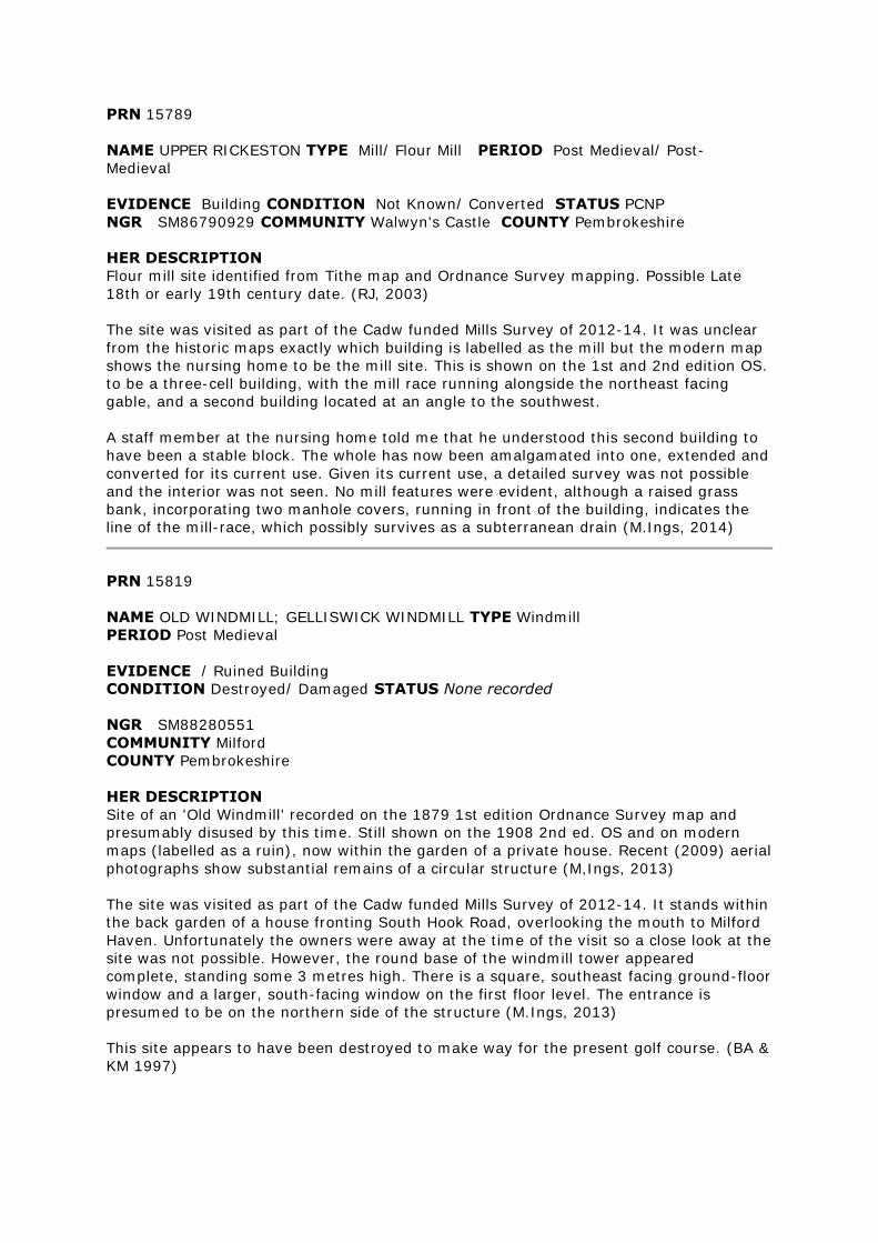
PRN 15789
NAME UPPER RICKESTON TYPE Mill/ Flour Mill PERIOD Post Medieval/ Post-
Medieval
EVIDENCE Building CONDITION Not Known/ Converted STATUS PCNP
NGR SM86790929 COMMUNITY Walwyn's Castle COUNTY Pembrokeshire
HER DESCRIPTION
Flour mill site identified from Tithe map and Ordnance Survey mapping. Possible Late
18th or early 19th century date. (RJ, 2003)
The site was visited as part of the Cadw funded Mills Survey of 2012-14. It was unclear
from the historic maps exactly which building is labelled as the mill but the modern map
shows the nursing home to be the mill site. This is shown on the 1st and 2nd edition OS.
to be a three-cell building, with the mill race running alongside the northeast facing
gable, and a second building located at an angle to the southwest.
A staff member at the nursing home told me that he understood this second building to
have been a stable block. The whole has now been amalgamated into one, extended and
converted for its current use. Given its current use, a detailed survey was not possible
and the interior was not seen. No mill features were evident, although a raised grass
bank, incorporating two manhole covers, running in front of the building, indicates the
line of the mill-race, which possibly survives as a subterranean drain (M.Ings, 2014)
PRN 15819
NAME OLD WINDMILL; GELLISWICK WINDMILL TYPE Windmill
PERIOD Post Medieval
EVIDENCE / Ruined Building
CONDITION Destroyed/ Damaged STATUS None recorded
NGR SM88280551
COMMUNITY Milford
COUNTY Pembrokeshire
HER DESCRIPTION
Site of an 'Old Windmill' recorded on the 1879 1st edition Ordnance Survey map and
presumably disused by this time. Still shown on the 1908 2nd ed. OS and on modern
maps (labelled as a ruin), now within the garden of a private house. Recent (2009) aerial
photographs show substantial remains of a circular structure (M,Ings, 2013)
The site was visited as part of the Cadw funded Mills Survey of 2012-14. It stands within
the back garden of a house fronting South Hook Road, overlooking the mouth to Milford
Haven. Unfortunately the owners were away at the time of the visit so a close look at the
site was not possible. However, the round base of the windmill tower appeared
complete, standing some 3 metres high. There is a square, southeast facing ground-floor
window and a larger, south-facing window on the first floor level. The entrance is
presumed to be on the northern side of the structure (M.Ings, 2013)
This site appears to have been destroyed to make way for the present golf course. (BA &
KM 1997)
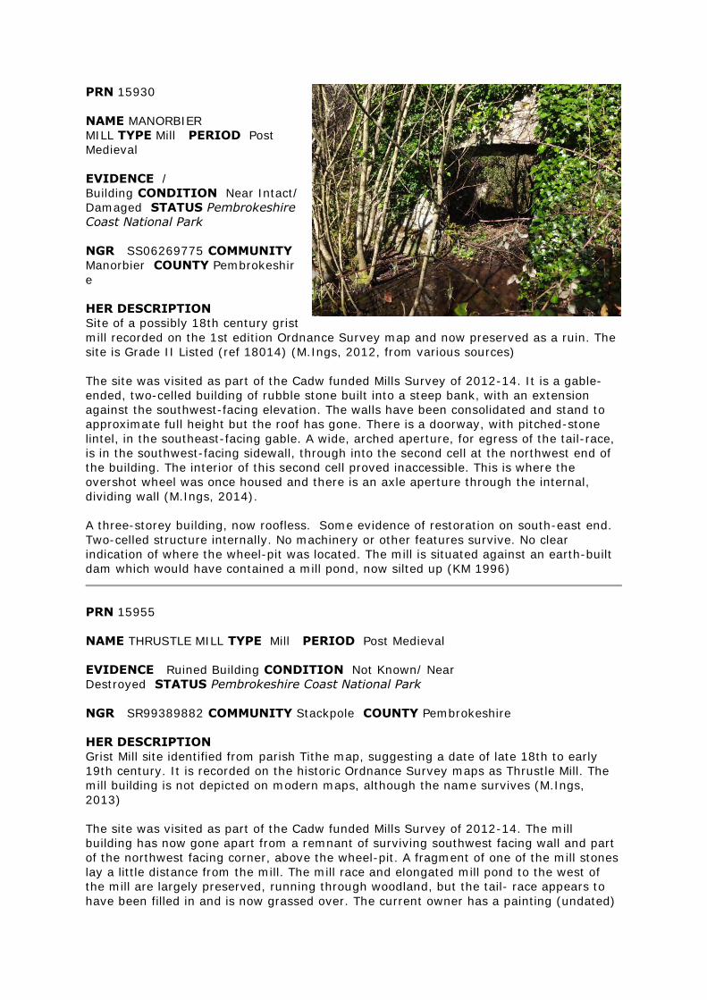
PRN 15930
NAME MANORBIER
MILL TYPE Mill PERIOD Post
Medieval
EVIDENCE /
Building CONDITION Near Intact/
Damaged STATUS Pembrokeshire
Coast National Park
NGR SS06269775 COMMUNITY
Manorbier COUNTY Pembrokeshir
e
HER DESCRIPTION
Site of a possibly 18th century grist
mill recorded on the 1st edition Ordnance Survey map and now preserved as a ruin. The
site is Grade II Listed (ref 18014) (M.Ings, 2012, from various sources)
The site was visited as part of the Cadw funded Mills Survey of 2012-14. It is a gable-
ended, two-celled building of rubble stone built into a steep bank, with an extension
against the southwest-facing elevation. The walls have been consolidated and stand to
approximate full height but the roof has gone. There is a doorway, with pitched-stone
lintel, in the southeast-facing gable. A wide, arched aperture, for egress of the tail-race,
is in the southwest-facing sidewall, through into the second cell at the northwest end of
the building. The interior of this second cell proved inaccessible. This is where the
overshot wheel was once housed and there is an axle aperture through the internal,
dividing wall (M.Ings, 2014).
A three-storey building, now roofless. Some evidence of restoration on south-east end.
Two-celled structure internally. No machinery or other features survive. No clear
indication of where the wheel-pit was located. The mill is situated against an earth-built
dam which would have contained a mill pond, now silted up (KM 1996)
PRN 15955
NAME THRUSTLE MILL TYPE Mill PERIOD Post Medieval
EVIDENCE Ruined Building CONDITION Not Known/ Near
Destroyed STATUS Pembrokeshire Coast National Park
NGR SR99389882 COMMUNITY Stackpole COUNTY Pembrokeshire
HER DESCRIPTION
Grist Mill site identified from parish Tithe map, suggesting a date of late 18th to early
19th century. It is recorded on the historic Ordnance Survey maps as Thrustle Mill. The
mill building is not depicted on modern maps, although the name survives (M.Ings,
2013)
The site was visited as part of the Cadw funded Mills Survey of 2012-14. The mill
building has now gone apart from a remnant of surviving southwest facing wall and part
of the northwest facing corner, above the wheel-pit. A fragment of one of the mill stones
lay a little distance from the mill. The mill race and elongated mill pond to the west of
the mill are largely preserved, running through woodland, but the tail- race appears to
have been filled in and is now grassed over. The current owner has a painting (undated)
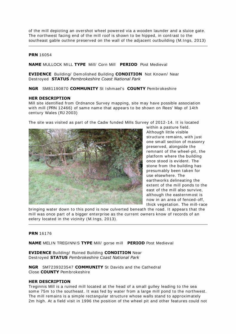
of the mill depicting an overshot wheel powered via a wooden launder and a sluice gate.
The northwest facing end of the mill roof is shown to be hipped, in contrast to the
southeast gable outline preserved on the wall of the adjacent outbuilding (M.Ings, 2013)
PRN 16054
NAME MULLOCK MILL TYPE Mill/ Corn Mill PERIOD Post Medieval
EVIDENCE Building/ Demolished Building CONDITION Not Known/ Near
Destroyed STATUS Pembrokeshire Coast National Park
NGR SM81190870 COMMUNITY St Ishmael's COUNTY Pembrokeshire
HER DESCRIPTION
Mill site identified from Ordnance Survey mapping, site may have possible association
with mill (PRN 12466) of same name that appears to be shown on Rees' Map of 14th
century Wales (RJ 2003)
The site was visited as part of the Cadw funded Mills Survey of 2012-14. It is located
within a pasture field.
Although little visible
structure remains, with just
one small section of masonry
preserved, alongside the
remnant of the wheel-pit, the
platform where the building
once stood is evident. The
stone from the building has
presumably been taken for
use elsewhere. The
earthworks delineating the
extent of the mill ponds to the
east of the mill also survive,
although the easternmost is
now in an area of fenced-off,
thick vegetation. The mill-race
bringing water down to this pond is now culverted beneath the road. It appears that the
mill was once part of a bigger enterprise as the current owners know of records of an
eelery located in the vicinity (M.Ings, 2013).
PRN 16176
NAME MELIN TREGINNIS TYPE Mill/ gorse mill PERIOD Post Medieval
EVIDENCE Building/ Ruined Building CONDITION Near
Destroyed STATUS Pembrokeshire Coast National Park
NGR SM7239323547 COMMUNITY St Davids and the Cathedral
Close COUNTY Pembrokeshire
HER DESCRIPTION
Treginnis Mill is a ruined mill located at the head of a small gulley leading to the sea
some 75m to the southeast. It was fed by water from a large mill pond to the northwest.
The mill remains is a simple rectangular structure whose walls stand to approximately
2m high. At a field visit in 1996 the position of the wheel pit and other features could not
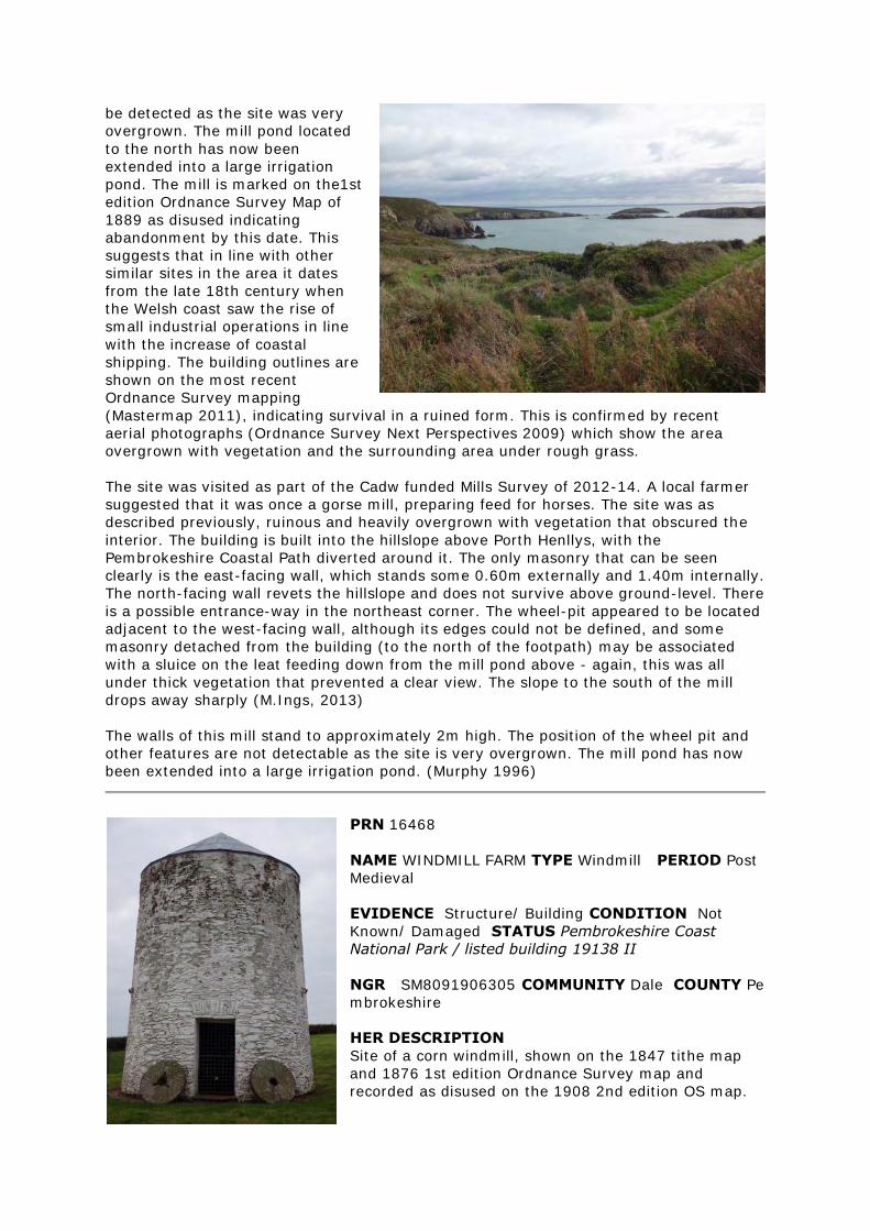
be detected as the site was very
overgrown. The mill pond located
to the north has now been
extended into a large irrigation
pond. The mill is marked on the1st
edition Ordnance Survey Map of
1889 as disused indicating
abandonment by this date. This
suggests that in line with other
similar sites in the area it dates
from the late 18th century when
the Welsh coast saw the rise of
small industrial operations in line
with the increase of coastal
shipping. The building outlines are
shown on the most recent
Ordnance Survey mapping
(Mastermap 2011), indicating survival in a ruined form. This is confirmed by recent
aerial photographs (Ordnance Survey Next Perspectives 2009) which show the area
overgrown with vegetation and the surrounding area under rough grass.
The site was visited as part of the Cadw funded Mills Survey of 2012-14. A local farmer
suggested that it was once a gorse mill, preparing feed for horses. The site was as
described previously, ruinous and heavily overgrown with vegetation that obscured the
interior. The building is built into the hillslope above Porth Henllys, with the
Pembrokeshire Coastal Path diverted around it. The only masonry that can be seen
clearly is the east-facing wall, which stands some 0.60m externally and 1.40m internally.
The north-facing wall revets the hillslope and does not survive above ground-level. There
is a possible entrance-way in the northeast corner. The wheel-pit appeared to be located
adjacent to the west-facing wall, although its edges could not be defined, and some
masonry detached from the building (to the north of the footpath) may be associated
with a sluice on the leat feeding down from the mill pond above - again, this was all
under thick vegetation that prevented a clear view. The slope to the south of the mill
drops away sharply (M.Ings, 2013)
The walls of this mill stand to approximately 2m high. The position of the wheel pit and
other features are not detectable as the site is very overgrown. The mill pond has now
been extended into a large irrigation pond. (Murphy 1996)
PRN 16468
NAME WINDMILL FARM TYPE Windmill PERIOD Post
Medieval
EVIDENCE Structure/ Building CONDITION Not
Known/ Damaged STATUS Pembrokeshire Coast
National Park / listed building 19138 II
NGR SM8091906305 COMMUNITY Dale COUNTY Pe
mbrokeshire
HER DESCRIPTION
Site of a corn windmill, shown on the 1847 tithe map
and 1876 1st edition Ordnance Survey map and
recorded as disused on the 1908 2nd edition OS map.
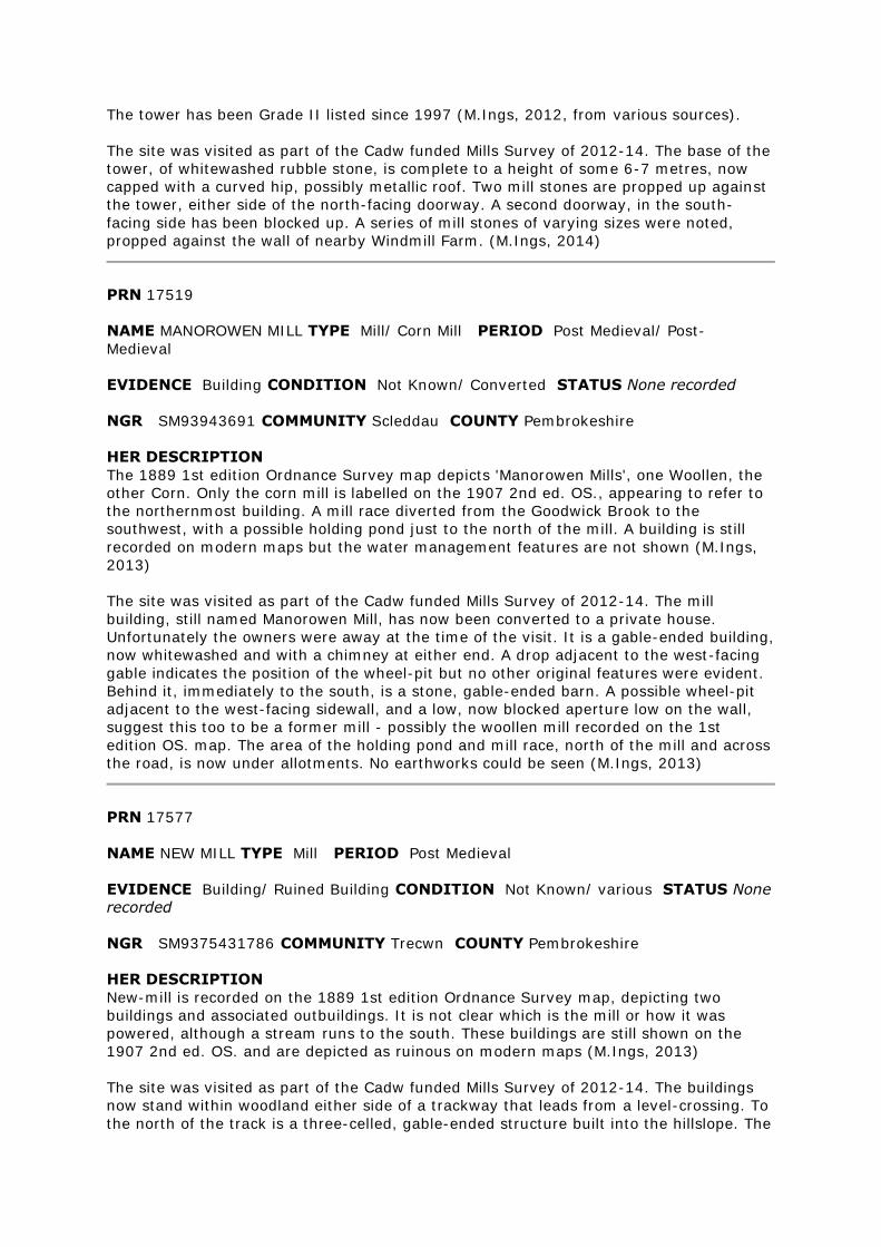
The tower has been Grade II listed since 1997 (M.Ings, 2012, from various sources).
The site was visited as part of the Cadw funded Mills Survey of 2012-14. The base of the
tower, of whitewashed rubble stone, is complete to a height of some 6-7 metres, now
capped with a curved hip, possibly metallic roof. Two mill stones are propped up against
the tower, either side of the north-facing doorway. A second doorway, in the south-
facing side has been blocked up. A series of mill stones of varying sizes were noted,
propped against the wall of nearby Windmill Farm. (M.Ings, 2014)
PRN 17519
NAME MANOROWEN MILL TYPE Mill/ Corn Mill PERIOD Post Medieval/ Post-
Medieval
EVIDENCE Building CONDITION Not Known/ Converted STATUS None recorded
NGR SM93943691 COMMUNITY Scleddau COUNTY Pembrokeshire
HER DESCRIPTION
The 1889 1st edition Ordnance Survey map depicts 'Manorowen Mills', one Woollen, the
other Corn. Only the corn mill is labelled on the 1907 2nd ed. OS., appearing to refer to
the northernmost building. A mill race diverted from the Goodwick Brook to the
southwest, with a possible holding pond just to the north of the mill. A building is still
recorded on modern maps but the water management features are not shown (M.Ings,
2013)
The site was visited as part of the Cadw funded Mills Survey of 2012-14. The mill
building, still named Manorowen Mill, has now been converted to a private house.
Unfortunately the owners were away at the time of the visit. It is a gable-ended building,
now whitewashed and with a chimney at either end. A drop adjacent to the west-facing
gable indicates the position of the wheel-pit but no other original features were evident.
Behind it, immediately to the south, is a stone, gable-ended barn. A possible wheel-pit
adjacent to the west-facing sidewall, and a low, now blocked aperture low on the wall,
suggest this too to be a former mill - possibly the woollen mill recorded on the 1st
edition OS. map. The area of the holding pond and mill race, north of the mill and across
the road, is now under allotments. No earthworks could be seen (M.Ings, 2013)
PRN 17577
NAME NEW MILL TYPE Mill PERIOD Post Medieval
EVIDENCE Building/ Ruined Building CONDITION Not Known/ various STATUS None
recorded
NGR SM9375431786 COMMUNITY Trecwn COUNTY Pembrokeshire
HER DESCRIPTION
New-mill is recorded on the 1889 1st edition Ordnance Survey map, depicting two
buildings and associated outbuildings. It is not clear which is the mill or how it was
powered, although a stream runs to the south. These buildings are still shown on the
1907 2nd ed. OS. and are depicted as ruinous on modern maps (M.Ings, 2013)
The site was visited as part of the Cadw funded Mills Survey of 2012-14. The buildings
now stand within woodland either side of a trackway that leads from a level-crossing. To
the north of the track is a three-celled, gable-ended structure built into the hillslope. The
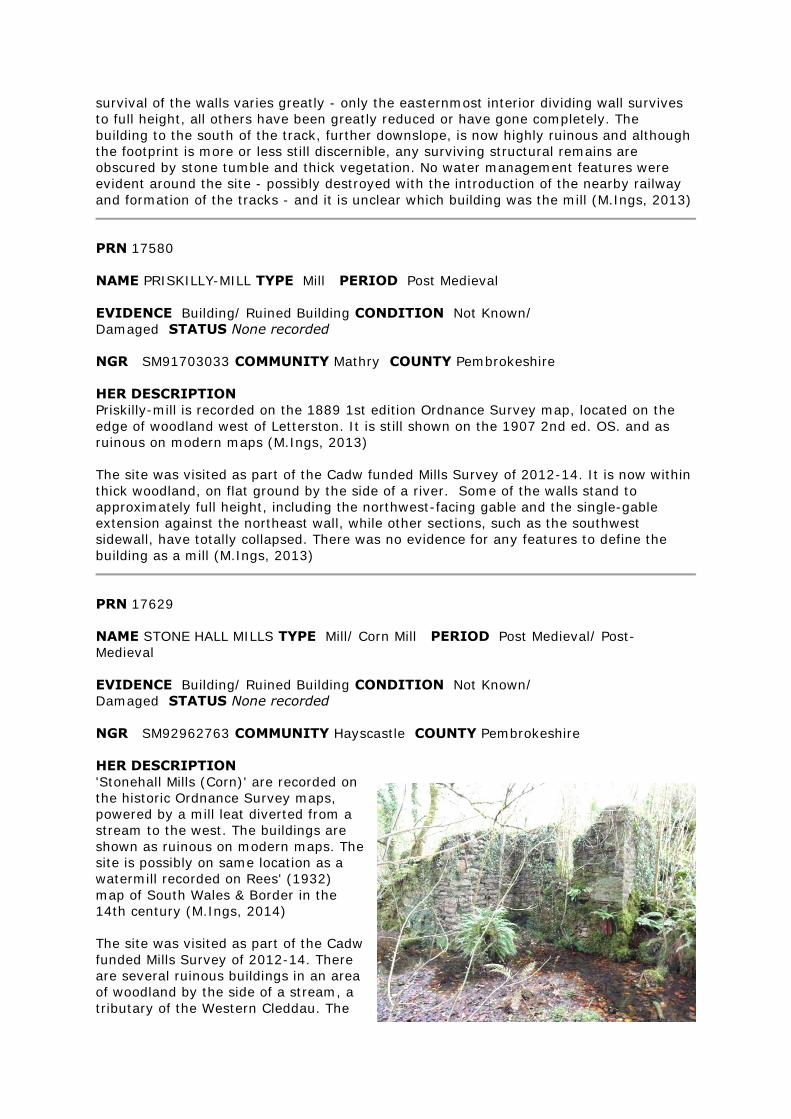
survival of the walls varies greatly - only the easternmost interior dividing wall survives
to full height, all others have been greatly reduced or have gone completely. The
building to the south of the track, further downslope, is now highly ruinous and although
the footprint is more or less still discernible, any surviving structural remains are
obscured by stone tumble and thick vegetation. No water management features were
evident around the site - possibly destroyed with the introduction of the nearby railway
and formation of the tracks - and it is unclear which building was the mill (M.Ings, 2013)
PRN 17580
NAME PRISKILLY-MILL TYPE Mill PERIOD Post Medieval
EVIDENCE Building/ Ruined Building CONDITION Not Known/
Damaged STATUS None recorded
NGR SM91703033 COMMUNITY Mathry COUNTY Pembrokeshire
HER DESCRIPTION
Priskilly-mill is recorded on the 1889 1st edition Ordnance Survey map, located on the
edge of woodland west of Letterston. It is still shown on the 1907 2nd ed. OS. and as
ruinous on modern maps (M.Ings, 2013)
The site was visited as part of the Cadw funded Mills Survey of 2012-14. It is now within
thick woodland, on flat ground by the side of a river. Some of the walls stand to
approximately full height, including the northwest-facing gable and the single-gable
extension against the northeast wall, while other sections, such as the southwest
sidewall, have totally collapsed. There was no evidence for any features to define the
building as a mill (M.Ings, 2013)
PRN 17629
NAME STONE HALL MILLS TYPE Mill/ Corn Mill PERIOD Post Medieval/ Post-
Medieval
EVIDENCE Building/ Ruined Building CONDITION Not Known/
Damaged STATUS None recorded
NGR SM92962763 COMMUNITY Hayscastle COUNTY Pembrokeshire
HER DESCRIPTION
'Stonehall Mills (Corn)' are recorded on
the historic Ordnance Survey maps,
powered by a mill leat diverted from a
stream to the west. The buildings are
shown as ruinous on modern maps. The
site is possibly on same location as a
watermill recorded on Rees' (1932)
map of South Wales & Border in the
14th century (M.Ings, 2014)
The site was visited as part of the Cadw
funded Mills Survey of 2012-14. There
are several ruinous buildings in an area
of woodland by the side of a stream, a
tributary of the Western Cleddau. The
historic maps indicate the mill race to run down between two buildings before the tail
race returns it to the stream. The building to the east is a two-cell structure. Some of
the walls survive to almost full height, others, particularly the south-facing elevation,
have collapsed. The interior is obscured by stone tumble, piled against the interior walls
and preventing a view of the building floor, and vegetation. Many young trees are also
growing within the ruins. A possible wheel-pit, which would have accommodated an
overshot wheel, was noted alongside the west-facing end wall. Here there is an arched
aperture through the wall - possibly where the wheel axle once fitted. A rectangular
recess in the ground on the inside of this wall may indicate the position of a hurst-frame
but no certain mill features were evident. The building to the west is more substantial
and the walls survive to approximately full height, with two arched windows in the north-
facing elevation and an arched doorway in the west-facing wall. The interior was
inaccessible. This was thought to be a house associated with the mill, although it is
possible that, given the plurality of the site name, it could be a second mill. No features
to indicate it as such were evident. The historic maps suggest the mill race feeds into a
holding pond, the flow then controlled by a sluice, to the south of these two buildings.
There is a curving stone wall standing some 3 metres high which may be the retaining
wall of the pond located above the mill. Thick vegetation prevented further exploration of
this feature. The mill race could be seen surviving as an earthwork to the southwest of
the buildings but could not be traced far due to access problems (M.Ings, 2014)
PRN 17650
NAME TYPE Mill Race PERIOD Post Medieval
EVIDENCE Earthwork CONDITION Not Known STATUS None recorded
NGR SM94041416 COMMUNITY Merlin's Bridge COUNTY Pembrokeshire
HER DESCRIPTION
Mill Race shown on Parish Tithe supplying water to Haroldston Mill PRN 17933. Race also
acts as Parish Boundary at this point. Race survives along majority of section west of
Merlin Brook Bridge PRN 43096 (RJ, 2001)
PRN 17674
NAME NANT-Y-COY MILL TYPE Mill Pond/ Mill Race PERIOD Post Medieval
EVIDENCE Structure CONDITION Near Intact STATUS None recorded
NGR SM95252530 COMMUNITY Wolfscastle COUNTY Pembrokeshire
HER DESCRIPTION
Mill pond and mill race recorded on the historical Ordnance Survey maps providing
power for 19th century Nantycoy corn mill (PRN 8919). The mill is now restored and
these water management features are still shown on modern mapping (M.Ings, 2012).
PRN 17691
NAME LEWESTON OLD MILL TYPE Mill PERIOD Post Medieval
EVIDENCE Ruined Building CONDITION Not Known/ Near Destroyed STATUS None
recorded
NGR SM94202217 COMMUNITY Camrose COUNTY Pembrokeshire
HER DESCRIPTION
Site of an 'Old Mill' recorded on the 1889 1st edition Ordnance Survey map and
presumed disused by this time. It is unclear how it was powered, although it is probable
that water was diverted from the stream that runs to the south. Rees records (1932) a
medieval mill (PRN 12518) in the vicinity and it is likely that it stood on the same site.
The old mill is still recorded on the 1907 2nd edition OS - possibly still roofed - and is
shown in outline on modern maps (M.Ings, 2013)
The site was visited as part of the Cadw funded Mills Survey of 2012-14. It is located
adjacent to a trackway, in an area of thick, overgrown woodland. It was not possible to
gain a clear view of the mill but it was evident that structural remains were preserved,
standing in part to a height of 0.75m, although largely obscured by stone tumble and
impenetrable vegetation. No features were discerned that could be used to positively
identify the ruins as a mill and the area would require clearing to understand the site
(M.Ings, 2013)
PRN 17695
NAME WOLFSDALE MILL TYPE Mill/ Corn Mill PERIOD Post Medieval/ Post-Medieval
EVIDENCE Building/ Demolished Building CONDITION Not Known/
Destroyed STATUS None recorded
NGR SM92922134 COMMUNITY Camrose COUNTY Pembrokeshire
HER DESCRIPTION
Site of a corn mill recorded on the 1889 1st edition Ordnance Survey map powered by a
mill stream diverted, via an extensive mill pond, from a stream to the west. The 1907
2nd ed. OS. suggests that the mill was no longer roofed by this time and it is no longer
shown on modern maps. The site possibly has earlier origins as a medieval mill is
recorded in the vicinity, although now of uncertain location, on Rees' (1932) map of
South Wales & Border in the 14th century (M.Ings, 2014)
The site was visited as part of the Cadw funded Mills Survey of 2012-14. It is located
within the grounds of a private house and, as the owners were away, only a cursory look
was possible. There were no structural remains of the mill evident but, at the location
recorded on the historic OS. maps, there was a clearly defined building platform cut into
the bank above the stream. This was only viewed from the pathway above but appeared
to be cut, at least in part, into the underlying bedrock. The area is now under grass,
scrub and on the edge of woodland. An ornamental pond is all that appears to survive of
the once much larger mill pond but the line of the mill stream was not traced as it now
crosses private gardens (M.Ings, 2014)
PRN 17724
NAME SPITTAL CORN MILL TYPE Mill/ Corn Mill PERIOD Post Medieval/ Post-
Medieval
EVIDENCE Building CONDITION Restored STATUS None recorded
NGR SM97402403 COMMUNITY Spittal COUNTY Pembrokeshire
HER DESCRIPTION
Spittal corn mill is recorded on the 1889 1st edition and 1907 2nd edition Ordnance
Survey maps, powered by a mill race.The building is still shown on modern mapping and
appears intact - restored /converted - on a recent aerial photograph (M.Ings, 2012, from
various sources)
The site was visited as part of the Cadw funded Mills Survey of 2012-14. It was clear
that the mill building was being restored but, as the owners were away, only a cursory
look was possible. The mill is of rubble stone, gable-ended, the southwest-facing gable
adjoined to the house. The roof is now of corrugated tin. The wheel-pit is alongside the
northeast gable and a wooden wheel axle is in place within the aperture through the
wall. There is a doorway within the northwest facing elevation. The interior was not seen
and the southeast elevation was obscured by a wooden and plastic extension. The mill
race, to the east of the mill, was not traced but the tail-race is preserved and still drains
water down to the stream (M.Ings, 2014)
Rees' map (1932), which purportedly shows South Wales & Border in the 14th century,
records a mill, Wood End (PRN 12522), in the vicinity. Its location is now uncertain but it
is possible that it was an earlier mill on the same site as Spittal (M.Ings, 2012)
PRN 17737
NAME CAMROSE TYPE Mill PERIOD Post Medieval
EVIDENCE Building CONDITION Converted STATUS listed building 25145 II
NGR SM9271019925 COMMUNITY Camrose COUNTY Pembrokeshire
HER DESCRIPTION
Camrose corn mill is believed to have been built in the early 19th century and is
recorded on the 1839 tithe map and the 1889 1st edition Ordnance Survey map. It has a
restored iron overshot waterwheel. The mill has been converted to residential use
(M.Ings, 2012, from various sources)
It is possible that there was an earlier, medieval mill (PRN 12512) on the site, recorded
by Rees (1932) on his map of South Wales & Border in the 14th century (M.Ings, 2012)
PRN 17741
NAME TYPE Mill Race PERIOD Post Medieval
EVIDENCE Earthwork CONDITION Not Known STATUS None recorded
NGR SM9470418214 COMMUNITY Rudbaxton COUNTY Pembrokeshire
HER DESCRIPTION
Mill race associated with Prendergast Mill (PRN 8777) recorded on the historic Ordnance
Survey maps (M.Ings, 2013)
PRN 17746
NAME CUCKOO TYPE Mill PERIOD Post Medieval
EVIDENCE Building CONDITION Not Known STATUS None recorded
NGR SM93101714 COMMUNITY Haverfordwest COUNTY Pembrokeshire
HER DESCRIPTION
Cuckoo Mill is recorded on the historic 1st and 2nd edition Ordnance maps, powered by a
leat feeding off the stream to the north. Modern mapping shows the mill to now be
incorporated within a more extensive farmstead complex and a recent aerial photograph
suggests that it has been restored or converted (M.Ings, 2012, from various sources)
PRN 17758
NAME WISTON MILL TYPE Mill/ Corn Mill PERIOD Post Medieval/ Post-Medieval
EVIDENCE Building CONDITION Not Known/ Converted STATUS None recorded
NGR SM98811890 COMMUNITY Wiston COUNTY Pembrokeshire
HER DESCRIPTION
Site of a corn mill shown on the 1810 Ordnance Survey original surveyors drawings and
recorded on the 1889 1st edition Ordnance Survey map. Disused by the time of the 1907
2nd ed. OS. There were initially only two buildings at the site and it is presumed that the
mill is the one located to the west, nearest the stream, although this is not certain.
'Wiston Mill' is still shown on modern maps, the name attached to an extended
farmstead (M.Ings, 2014)
The site was visited as part of the Cadw funded Mills Survey of 2012-14. Unfortunately,
as the owners were away, only a very cursory look was possible. The two buildings
shown on the 1st edition OS. map proved to be the farmhouse and, downslope towards
the stream and a railway line, two adjoining outbuildings constructed of rubble stone
now roofed with corrugated tin. These appear to now be livestock sheds and there were
no evident features to suggest a mill. However, as the footprint of these two buildings
matches that of the buildings shown on the historic OS. maps, it is possible that they
have been converted from the former mill (M.Ings, 2014)
PRN 17768
NAME CRUNDALE TYPE Mill/ Farm House PERIOD Post Medieval
EVIDENCE / Ruined Building CONDITION Not Known/ Damaged STATUS None
recorded
NGR SM9811217827 COMMUNITY Wiston COUNTY Pembrokeshire
HER DESCRIPTION
Crundale Mill is recorded on the 1889 1st edition Ordnance Survey map, although no
obvious source of water power is shown. A new building to the south is named as
Crundale Mill on the 1907 2nd ed. OS. and it is this, now ruinous, still so named on
modern mapping (M.Ings, 2013)
The site was visited as part of the Cadw funded Mills Survey of 2012-14. The ruinous
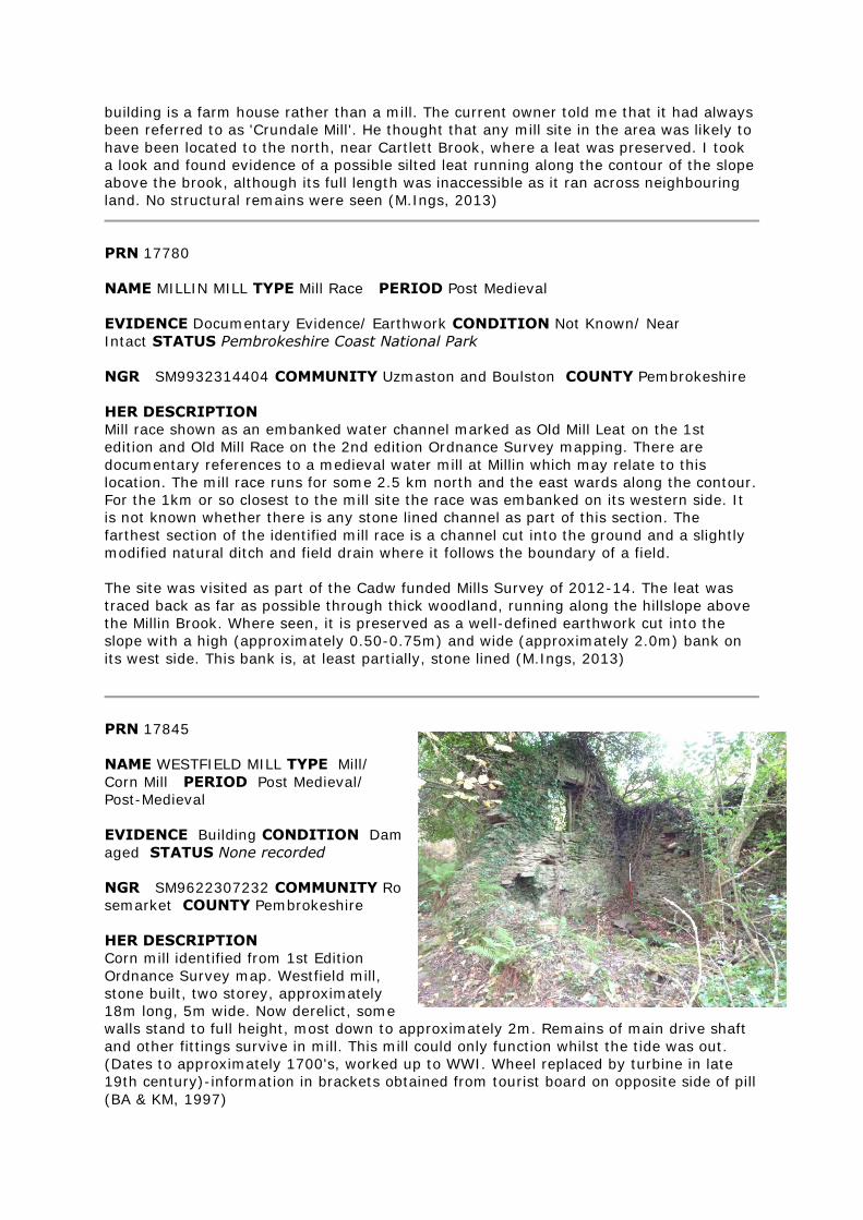
building is a farm house rather than a mill. The current owner told me that it had always
been referred to as 'Crundale Mill'. He thought that any mill site in the area was likely to
have been located to the north, near Cartlett Brook, where a leat was preserved. I took
a look and found evidence of a possible silted leat running along the contour of the slope
above the brook, although its full length was inaccessible as it ran across neighbouring
land. No structural remains were seen (M.Ings, 2013)
PRN 17780
NAME MILLIN MILL TYPE Mill Race PERIOD Post Medieval
EVIDENCE Documentary Evidence/ Earthwork CONDITION Not Known/ Near
Intact STATUS Pembrokeshire Coast National Park
NGR SM9932314404 COMMUNITY Uzmaston and Boulston COUNTY Pembrokeshire
HER DESCRIPTION
Mill race shown as an embanked water channel marked as Old Mill Leat on the 1st
edition and Old Mill Race on the 2nd edition Ordnance Survey mapping. There are
documentary references to a medieval water mill at Millin which may relate to this
location. The mill race runs for some 2.5 km north and the east wards along the contour.
For the 1km or so closest to the mill site the race was embanked on its western side. It
is not known whether there is any stone lined channel as part of this section. The
farthest section of the identified mill race is a channel cut into the ground and a slightly
modified natural ditch and field drain where it follows the boundary of a field.
The site was visited as part of the Cadw funded Mills Survey of 2012-14. The leat was
traced back as far as possible through thick woodland, running along the hillslope above
the Millin Brook. Where seen, it is preserved as a well-defined earthwork cut into the
slope with a high (approximately 0.50-0.75m) and wide (approximately 2.0m) bank on
its west side. This bank is, at least partially, stone lined (M.Ings, 2013)
PRN 17845
NAME WESTFIELD MILL TYPE Mill/
Corn Mill PERIOD Post Medieval/
Post-Medieval
EVIDENCE Building CONDITION Dam
aged STATUS None recorded
NGR SM9622307232 COMMUNITY Ro
semarket COUNTY Pembrokeshire
HER DESCRIPTION
Corn mill identified from 1st Edition
Ordnance Survey map. Westfield mill,
stone built, two storey, approximately
18m long, 5m wide. Now derelict, some
walls stand to full height, most down to approximately 2m. Remains of main drive shaft
and other fittings survive in mill. This mill could only function whilst the tide was out.
(Dates to approximately 1700's, worked up to WWI. Wheel replaced by turbine in late
19th century)-information in brackets obtained from tourist board on opposite side of pill
(BA & KM, 1997)
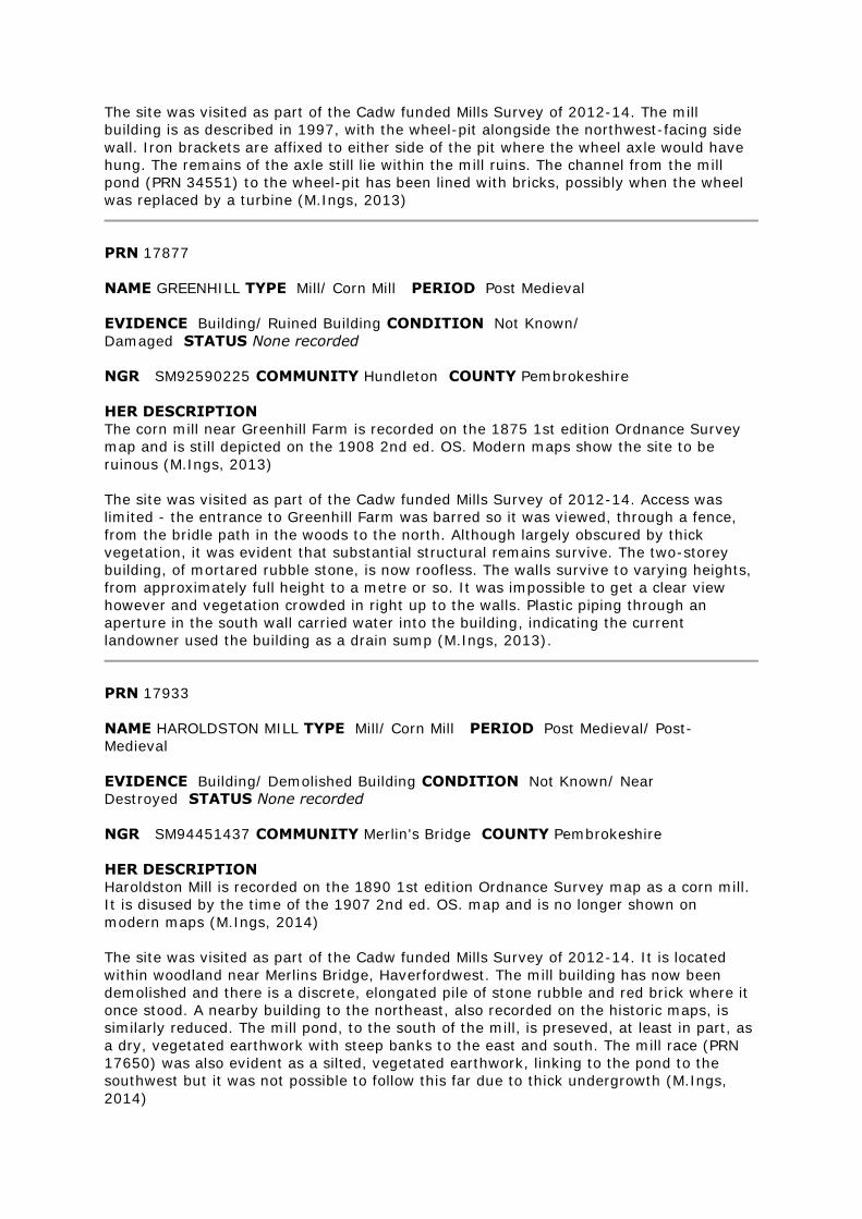
The site was visited as part of the Cadw funded Mills Survey of 2012-14. The mill
building is as described in 1997, with the wheel-pit alongside the northwest-facing side
wall. Iron brackets are affixed to either side of the pit where the wheel axle would have
hung. The remains of the axle still lie within the mill ruins. The channel from the mill
pond (PRN 34551) to the wheel-pit has been lined with bricks, possibly when the wheel
was replaced by a turbine (M.Ings, 2013)
PRN 17877
NAME GREENHILL TYPE Mill/ Corn Mill PERIOD Post Medieval
EVIDENCE Building/ Ruined Building CONDITION Not Known/
Damaged STATUS None recorded
NGR SM92590225 COMMUNITY Hundleton COUNTY Pembrokeshire
HER DESCRIPTION
The corn mill near Greenhill Farm is recorded on the 1875 1st edition Ordnance Survey
map and is still depicted on the 1908 2nd ed. OS. Modern maps show the site to be
ruinous (M.Ings, 2013)
The site was visited as part of the Cadw funded Mills Survey of 2012-14. Access was
limited - the entrance to Greenhill Farm was barred so it was viewed, through a fence,
from the bridle path in the woods to the north. Although largely obscured by thick
vegetation, it was evident that substantial structural remains survive. The two-storey
building, of mortared rubble stone, is now roofless. The walls survive to varying heights,
from approximately full height to a metre or so. It was impossible to get a clear view
however and vegetation crowded in right up to the walls. Plastic piping through an
aperture in the south wall carried water into the building, indicating the current
landowner used the building as a drain sump (M.Ings, 2013).
PRN 17933
NAME HAROLDSTON MILL TYPE Mill/ Corn Mill PERIOD Post Medieval/ Post-
Medieval
EVIDENCE Building/ Demolished Building CONDITION Not Known/ Near
Destroyed STATUS None recorded
NGR SM94451437 COMMUNITY Merlin's Bridge COUNTY Pembrokeshire
HER DESCRIPTION
Haroldston Mill is recorded on the 1890 1st edition Ordnance Survey map as a corn mill.
It is disused by the time of the 1907 2nd ed. OS. map and is no longer shown on
modern maps (M.Ings, 2014)
The site was visited as part of the Cadw funded Mills Survey of 2012-14. It is located
within woodland near Merlins Bridge, Haverfordwest. The mill building has now been
demolished and there is a discrete, elongated pile of stone rubble and red brick where it
once stood. A nearby building to the northeast, also recorded on the historic maps, is
similarly reduced. The mill pond, to the south of the mill, is preseved, at least in part, as
a dry, vegetated earthwork with steep banks to the east and south. The mill race (PRN
17650) was also evident as a silted, vegetated earthwork, linking to the pond to the
southwest but it was not possible to follow this far due to thick undergrowth (M.Ings,
2014)
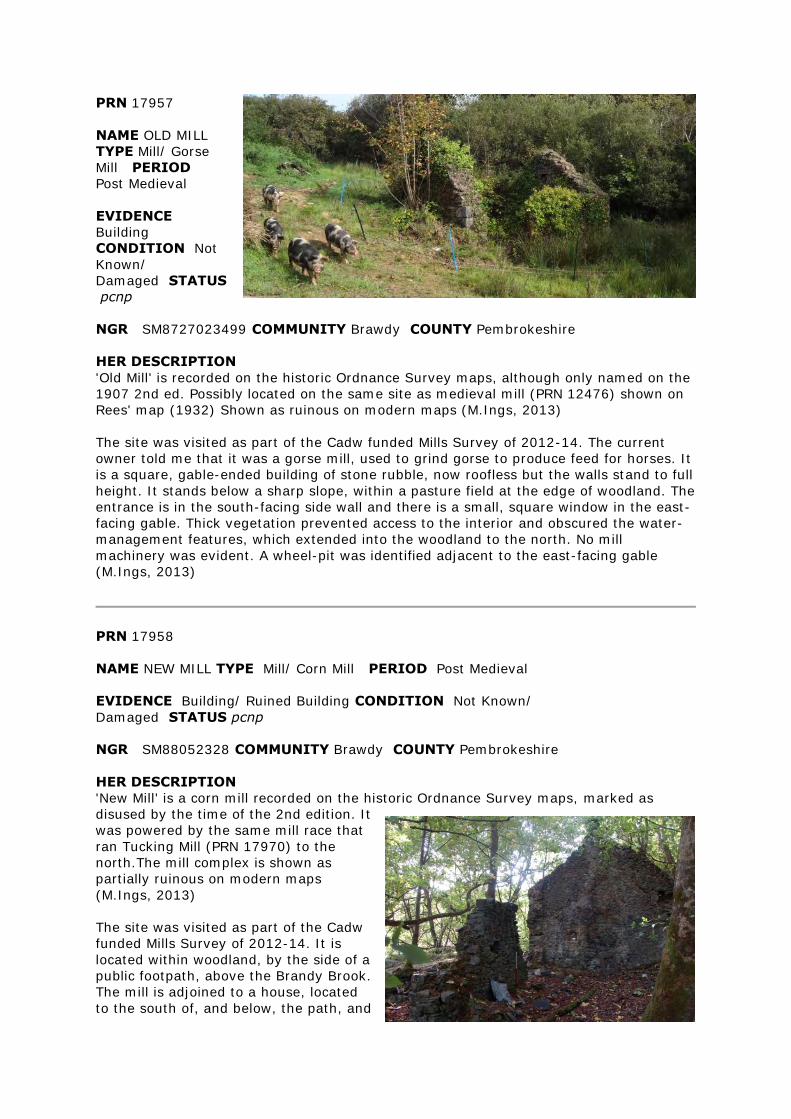
PRN 17957
NAME OLD MILL
TYPE Mill/ Gorse
Mill PERIOD
Post Medieval
EVIDENCE
Building
CONDITION Not
Known/
Damaged STATUS
pcnp
NGR SM8727023499 COMMUNITY Brawdy COUNTY Pembrokeshire
HER DESCRIPTION
'Old Mill' is recorded on the historic Ordnance Survey maps, although only named on the
1907 2nd ed. Possibly located on the same site as medieval mill (PRN 12476) shown on
Rees' map (1932) Shown as ruinous on modern maps (M.Ings, 2013)
The site was visited as part of the Cadw funded Mills Survey of 2012-14. The current
owner told me that it was a gorse mill, used to grind gorse to produce feed for horses. It
is a square, gable-ended building of stone rubble, now roofless but the walls stand to full
height. It stands below a sharp slope, within a pasture field at the edge of woodland. The
entrance is in the south-facing side wall and there is a small, square window in the east-
facing gable. Thick vegetation prevented access to the interior and obscured the water-
management features, which extended into the woodland to the north. No mill
machinery was evident. A wheel-pit was identified adjacent to the east-facing gable
(M.Ings, 2013)
PRN 17958
NAME NEW MILL TYPE Mill/ Corn Mill PERIOD Post Medieval
EVIDENCE Building/ Ruined Building CONDITION Not Known/
Damaged STATUS pcnp
NGR SM88052328 COMMUNITY Brawdy COUNTY Pembrokeshire
HER DESCRIPTION
'New Mill' is a corn mill recorded on the historic Ordnance Survey maps, marked as
disused by the time of the 2nd edition. It
was powered by the same mill race that
ran Tucking Mill (PRN 17970) to the
north.The mill complex is shown as
partially ruinous on modern maps
(M.Ings, 2013)
The site was visited as part of the Cadw
funded Mills Survey of 2012-14. It is
located within woodland, by the side of a
public footpath, above the Brandy Brook.
The mill is adjoined to a house, located
to the south of, and below, the path, and
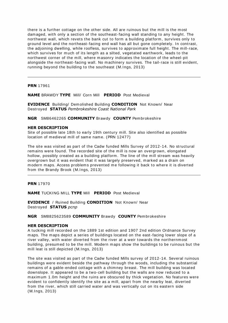
there is a further cottage on the other side. All are ruinous but the mill is the most
damaged, with only a section of the southeast-facing wall standing to any height. The
northwest wall, which revets the bank cut to form a building platform, survives only to
ground level and the northeast-facing end wall has all but gone completely. In contrast,
the adjoining dwelling, while roofless, survives to approximate full height. The mill-race,
which survives for much of its length as a silted, vegetated earthwork, leads to the
northwest corner of the mill, where masonry indicates the location of the wheel-pit
alongside the northeast-facing wall. No machinery survives. The tail-race is still evident,
running beyond the building to the southeast (M.Ings, 2013)
PRN 17961
NAME BRAWDY TYPE Mill/ Corn Mill PERIOD Post Medieval
EVIDENCE Building/ Demolished Building CONDITION Not Known/ Near
Destroyed STATUS Pembrokeshire Coast National Park
NGR SM86462265 COMMUNITY Brawdy COUNTY Pembrokeshire
HER DESCRIPTION
Site of possible late 18th to early 19th century mill. Site also identified as possible
location of medieval mill of same name. (PRN 12477)
The site was visited as part of the Cadw funded Mills Survey of 2012-14. No structural
remains were found. The recorded site of the mill is now an overgrown, elongated
hollow, possibly created as a building platform. The line of the mill stream was heavily
overgrown but it was evident that it was largely preserved, marked as a drain on
modern maps. Access problems prevented me following it back to where it is diverted
from the Brandy Brook (M.Ings, 2013)
PRN 17970
NAME TUCKING MILL TYPE Mill PERIOD Post Medieval
EVIDENCE / Ruined Building CONDITION Not Known/ Near
Destroyed STATUS pcnp
NGR SM8825623589 COMMUNITY Brawdy COUNTY Pembrokeshire
HER DESCRIPTION
A tucking mill recorded on the 1889 1st edition and 1907 2nd edition Ordnance Survey
maps. The maps depict a series of buildings located on the east-facing lower slope of a
river valley, with water diverted from the river at a weir towards the northernmost
building, presumed to be the mill. Modern maps show the buildings to be ruinous but the
mill leat is still depicted (M.Ings, 2013)
The site was visited as part of the Cadw funded Mills survey of 2012-14. Several ruinous
buildings were evident beside the pathway through the woods, including the substantial
remains of a gable-ended cottage with a chimney breast. The mill building was located
downslope. It appeared to be a two-cell building but the walls are now reduced to a
maximum 1.0m height and the ruins are obscured by thick vegetation. No features were
evident to confidently identify the site as a mill, apart from the nearby leat, diverted
from the river, which still carried water and was vertically cut on its eastern side
(M.Ings, 2013)
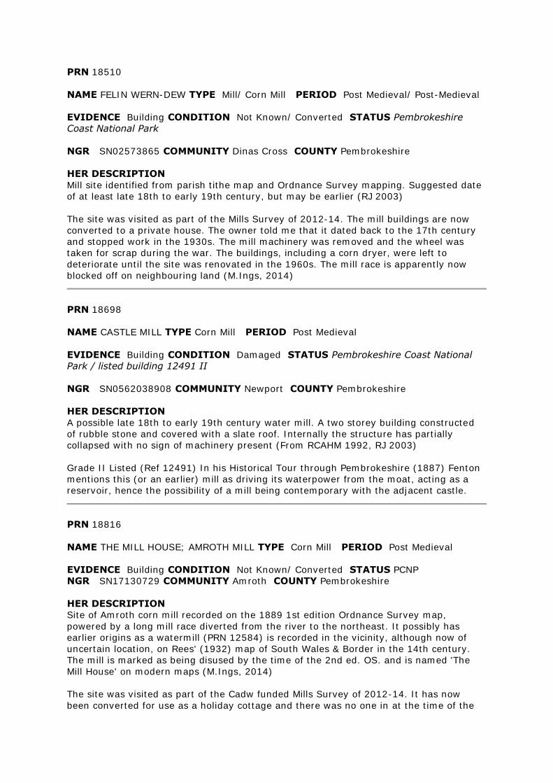
PRN 18510
NAME FELIN WERN-DEW TYPE Mill/ Corn Mill PERIOD Post Medieval/ Post-Medieval
EVIDENCE Building CONDITION Not Known/ Converted STATUS Pembrokeshire
Coast National Park
NGR SN02573865 COMMUNITY Dinas Cross COUNTY Pembrokeshire
HER DESCRIPTION
Mill site identified from parish tithe map and Ordnance Survey mapping. Suggested date
of at least late 18th to early 19th century, but may be earlier (RJ 2003)
The site was visited as part of the Mills Survey of 2012-14. The mill buildings are now
converted to a private house. The owner told me that it dated back to the 17th century
and stopped work in the 1930s. The mill machinery was removed and the wheel was
taken for scrap during the war. The buildings, including a corn dryer, were left to
deteriorate until the site was renovated in the 1960s. The mill race is apparently now
blocked off on neighbouring land (M.Ings, 2014)
PRN 18698
NAME CASTLE MILL TYPE Corn Mill PERIOD Post Medieval
EVIDENCE Building CONDITION Damaged STATUS Pembrokeshire Coast National
Park / listed building 12491 II
NGR SN0562038908 COMMUNITY Newport COUNTY Pembrokeshire
HER DESCRIPTION
A possible late 18th to early 19th century water mill. A two storey building constructed
of rubble stone and covered with a slate roof. Internally the structure has partially
collapsed with no sign of machinery present (From RCAHM 1992, RJ 2003)
Grade II Listed (Ref 12491) In his Historical Tour through Pembrokeshire (1887) Fenton
mentions this (or an earlier) mill as driving its waterpower from the moat, acting as a
reservoir, hence the possibility of a mill being contemporary with the adjacent castle.
PRN 18816
NAME THE MILL HOUSE; AMROTH MILL TYPE Corn Mill PERIOD Post Medieval
EVIDENCE Building CONDITION Not Known/ Converted STATUS PCNP
NGR SN17130729 COMMUNITY Amroth COUNTY Pembrokeshire
HER DESCRIPTION
Site of Amroth corn mill recorded on the 1889 1st edition Ordnance Survey map,
powered by a long mill race diverted from the river to the northeast. It possibly has
earlier origins as a watermill (PRN 12584) is recorded in the vicinity, although now of
uncertain location, on Rees' (1932) map of South Wales & Border in the 14th century.
The mill is marked as being disused by the time of the 2nd ed. OS. and is named 'The
Mill House' on modern maps (M.Ings, 2014)
The site was visited as part of the Cadw funded Mills Survey of 2012-14. It has now
been converted for use as a holiday cottage and there was no one in at the time of the
visit. It is a gable-ended building with a single storey extension against the northeast
facing gable. It is located below a steep bank and is now rendered and painted, with new
windows and a chimney at either end. A mill stone has been used as an outdoor table-
top but no other mill features were evident. The line of the tail-race was noted, now
infilled and grassed over, as a cropmark across the lawn. A footpath runs behind the mill
and the mill race could be traced for some distance, now a dry, vegetated earthwork
running through woodland. Access as far as the river was not possible (M.Ings, 2014)
Identified from Ordnance Survey Mapping. (RJ, 2004)
PRN 18967
NAME FELIN UCHAF TYPE Mill/ Corn Mill PERIOD Post Medieval
EVIDENCE Building/ Ruined Building CONDITION Not Known/
Damaged STATUS Pembrokeshire Coast National Park
NGR SN1657434512 COMMUNITY
Crymych COUNTY Pembrokeshire
HER DESCRIPTION
A possible late 18th to early
19th century corn mill shown on
tithe map. It is also recorded on
the historic Ordnance Survey
maps, powered by a mill race
diverted from the Afon Bannon
via a mill pond south of the mill
building. The mill is shown as a
ruin on modern maps but the
mill pond (PRN 105997) is
preserved (M.Ings, 2013)
The site was visited as part of
the Cadw funded Mills Survey of
2012-14. The mill building is
now a roofless ruin located in thick woodland. Some roof slate fragments were noted
within the interior. The walls stand to varying heights, from approximately full-height to
robbed completely. The mill is a two-cell building aligned northwest-southeast. There are
entrances in both sidewalls.The stone-lined wheel-pit survives alongside the northeast-
facing wall. The axle aperture still has the broken-off wooden wheel axle within it. A
niche on the outer wall indicates the position of a wooden launder that would have fed
the water to the top of an overshot wheel, but this has now gone. There is a walkway
alongside the wheel-pit, accessed by a stone bridge over the tail-race. Within the mill,
the iron axle wheel is preserved in situ, although obscured by silting and vegetation.
There is also a pair of mill-stones, with iron rims, still slotted onto an iron shaft. The area
immediately to the southwest of the mill was heavily overgrown and inaccessible so it
wasn't possible to trace the mill-race from the pond but, as water still flows into wheel-
pit, it is likely to survive. The pond (PRN 105997) itself is still a substantial feature
(M.Ings, 2013)
A possible late 18th to early 19th century corn mill shown on tithe map. (RJ, 2003)
PRN 19029
NAME FELIN-Y-GIGFRAN TYPE Corn Mill PERIOD Post Medieval
EVIDENCE Building/ Ruined Building CONDITION Not Known/ Near
Destroyed STATUS Pembrokeshire Coast National Park
NGR SN1210037230 COMMUNITY Eglwyswrw COUNTY Pembrokeshire
HER DESCRIPTION
Mill recorded on the historic Ordnance Survey maps, powered by a mill stream diverted
from the Afon Nyfer to the northeast. Not shown on modern maps (M.Ings, 2013)
The site was visited as part of the Cadw funded Mills Survey of 2012-14. It is located
beneath a steep bank, by the side of the Afon Nyfer. Little remains of the structure apart
from its footprint, with walls standing less than a metre high. The interior was
completely obscured by thick vegetation. The mill race is preserved as a silted,
vegetated earthwork but I could not find evidence of a wheel-pit (M.Ings, 2013)
Mill site identified from Ordnance Survey mapping. Meline tithe apportionment identifies
site as homestead no. 534. Mill has a suggested date of late 18th to early 19th century
PRN 19075
NAME FELIN-FACH-UCHAF TYPE Mill/ Cottage PERIOD Post Medieval/ Post-Medieval
EVIDENCE Building/ Ruined Building CONDITION Not Known/
Damaged STATUS Pembrokeshire Coast National Park
NGR SN13143540 COMMUNITY Eglwyswrw COUNTY Pembrokeshire
HER DESCRIPTION
Site identified from Ordnance Survey mapping. Name indicative of a mill site. Meline
parish tithe apportionment has site identified as homestead no. 333. (RJ, 2003)
The site was visited as part of the Cadw funded Mills Survey of 2012-14. The building is
located on the eastern bank of a stream but was evidently a, now ruinous, cottage with a
fireplace in the west-facing gable. The current landowners recalled the cottage still being
inhabited, some 70-80 years ago. The walls are damaged but still stand to approximate
full height but the building is now roofless. A second cottage, Felin-fach-ganol (PRN
105990), is located nearby to the north (M.Ings, 2014)
PRN 19076
NAME HEN-FELIN TYPE Mill/ Cottage PERIOD Post Medieval/ Post-Medieval
EVIDENCE Building CONDITION Not Known/ Damaged STATUS Pembrokeshire
Coast National Park
NGR SN1144735963 COMMUNITY Eglwyswrw COUNTY Pembrokeshire
HER DESCRIPTION
'Hen-felin' is recorded on the historic Ordnance Survey maps, its name indicating a mill
site. The building is still shown on modern maps (M.Ings, 2014)
The site was visited as part of the Cadw funded Mills Survey of 2012-14. Located within
woodland, it is now abandoned, ruinous and overgrown. It is built, of rubble stone into
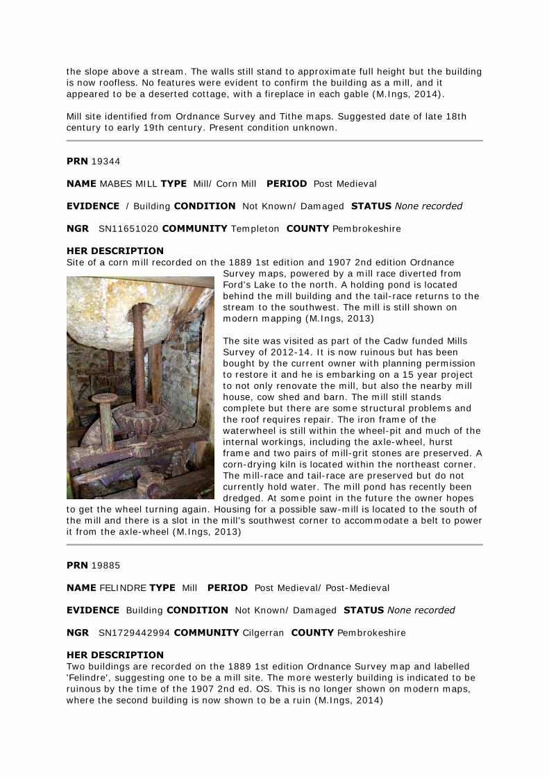
the slope above a stream. The walls still stand to approximate full height but the building
is now roofless. No features were evident to confirm the building as a mill, and it
appeared to be a deserted cottage, with a fireplace in each gable (M.Ings, 2014).
Mill site identified from Ordnance Survey and Tithe maps. Suggested date of late 18th
century to early 19th century. Present condition unknown.
PRN 19344
NAME MABES MILL TYPE Mill/ Corn Mill PERIOD Post Medieval
EVIDENCE / Building CONDITION Not Known/ Damaged STATUS None recorded
NGR SN11651020 COMMUNITY Templeton COUNTY Pembrokeshire
HER DESCRIPTION
Site of a corn mill recorded on the 1889 1st edition and 1907 2nd edition Ordnance
Survey maps, powered by a mill race diverted from
Ford's Lake to the north. A holding pond is located
behind the mill building and the tail-race returns to the
stream to the southwest. The mill is still shown on
modern mapping (M.Ings, 2013)
The site was visited as part of the Cadw funded Mills
Survey of 2012-14. It is now ruinous but has been
bought by the current owner with planning permission
to restore it and he is embarking on a 15 year project
to not only renovate the mill, but also the nearby mill
house, cow shed and barn. The mill still stands
complete but there are some structural problems and
the roof requires repair. The iron frame of the
waterwheel is still within the wheel-pit and much of the
internal workings, including the axle-wheel, hurst
frame and two pairs of mill-grit stones are preserved. A
corn-drying kiln is located within the northeast corner.
The mill-race and tail-race are preserved but do not
currently hold water. The mill pond has recently been
dredged. At some point in the future the owner hopes
to get the wheel turning again. Housing for a possible saw-mill is located to the south of
the mill and there is a slot in the mill's southwest corner to accommodate a belt to power
it from the axle-wheel (M.Ings, 2013)
PRN 19885
NAME FELINDRE TYPE Mill PERIOD Post Medieval/ Post-Medieval
EVIDENCE Building CONDITION Not Known/ Damaged STATUS None recorded
NGR SN1729442994 COMMUNITY Cilgerran COUNTY Pembrokeshire
HER DESCRIPTION
Two buildings are recorded on the 1889 1st edition Ordnance Survey map and labelled
'Felindre', suggesting one to be a mill site. The more westerly building is indicated to be
ruinous by the time of the 1907 2nd ed. OS. This is no longer shown on modern maps,
where the second building is now shown to be a ruin (M.Ings, 2014)
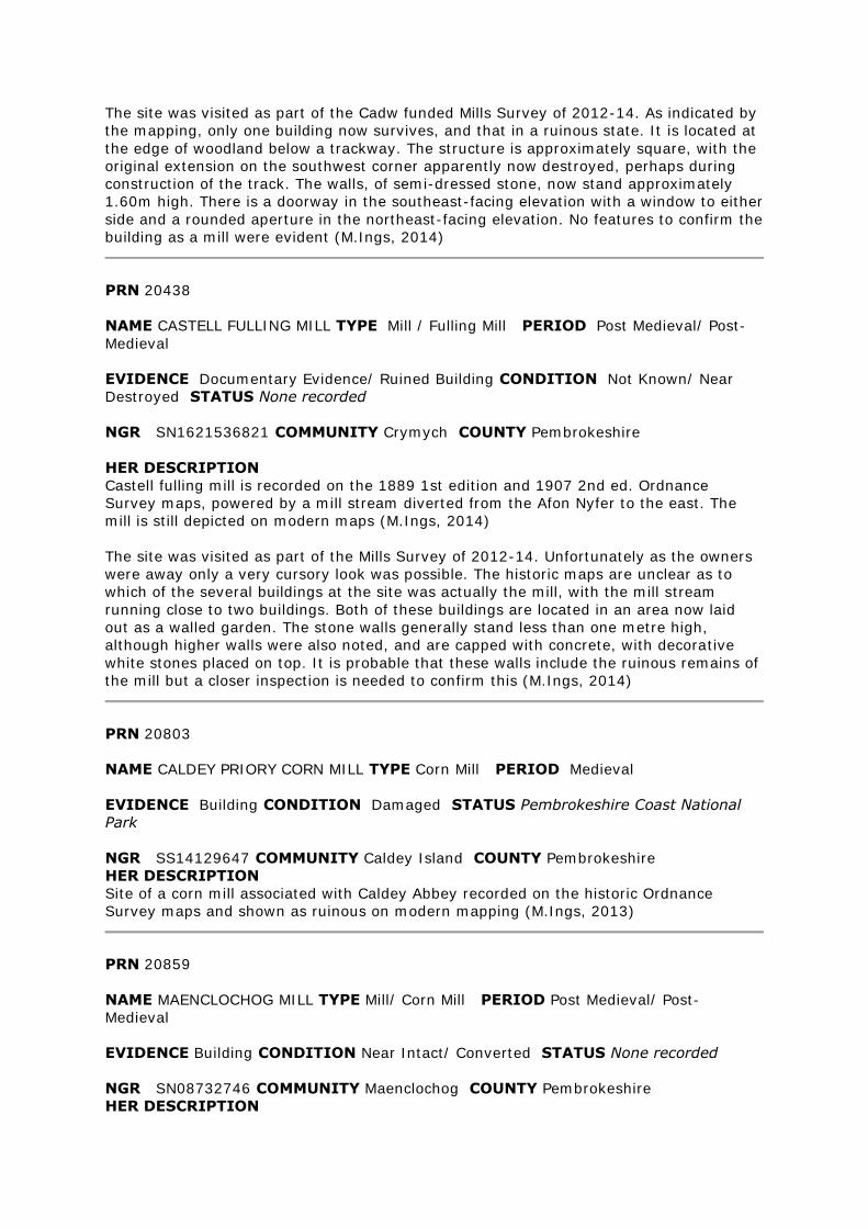
The site was visited as part of the Cadw funded Mills Survey of 2012-14. As indicated by
the mapping, only one building now survives, and that in a ruinous state. It is located at
the edge of woodland below a trackway. The structure is approximately square, with the
original extension on the southwest corner apparently now destroyed, perhaps during
construction of the track. The walls, of semi-dressed stone, now stand approximately
1.60m high. There is a doorway in the southeast-facing elevation with a window to either
side and a rounded aperture in the northeast-facing elevation. No features to confirm the
building as a mill were evident (M.Ings, 2014)
PRN 20438
NAME CASTELL FULLING MILL TYPE Mill / Fulling Mill PERIOD Post Medieval/ Post-
Medieval
EVIDENCE Documentary Evidence/ Ruined Building CONDITION Not Known/ Near
Destroyed STATUS None recorded
NGR SN1621536821 COMMUNITY Crymych COUNTY Pembrokeshire
HER DESCRIPTION
Castell fulling mill is recorded on the 1889 1st edition and 1907 2nd ed. Ordnance
Survey maps, powered by a mill stream diverted from the Afon Nyfer to the east. The
mill is still depicted on modern maps (M.Ings, 2014)
The site was visited as part of the Mills Survey of 2012-14. Unfortunately as the owners
were away only a very cursory look was possible. The historic maps are unclear as to
which of the several buildings at the site was actually the mill, with the mill stream
running close to two buildings. Both of these buildings are located in an area now laid
out as a walled garden. The stone walls generally stand less than one metre high,
although higher walls were also noted, and are capped with concrete, with decorative
white stones placed on top. It is probable that these walls include the ruinous remains of
the mill but a closer inspection is needed to confirm this (M.Ings, 2014)
PRN 20803
NAME CALDEY PRIORY CORN MILL TYPE Corn Mill PERIOD Medieval
EVIDENCE Building CONDITION Damaged STATUS Pembrokeshire Coast National
Park
NGR SS14129647 COMMUNITY Caldey Island COUNTY Pembrokeshire
HER DESCRIPTION
Site of a corn mill associated with Caldey Abbey recorded on the historic Ordnance
Survey maps and shown as ruinous on modern mapping (M.Ings, 2013)
PRN 20859
NAME MAENCLOCHOG MILL TYPE Mill/ Corn Mill PERIOD Post Medieval/ Post-
Medieval
EVIDENCE Building CONDITION Near Intact/ Converted STATUS None recorded
NGR SN08732746 COMMUNITY Maenclochog COUNTY Pembrokeshire
HER DESCRIPTION
Maenclochog Mill is recorded on the 1889 1st edition and 1907 2nd edition Ordnance
Survey maps, powered by a mill race (PRN 105999) taking water from a mill pond
located to the northwest. Modern mapping and a recent aerial photograph show the mill
building still standing and roofed, possibly restored and/or converted, but much of the
water management system is no longer recorded (M.Ings, 2012).
The site was visited as part of the Cadw Mills Project of 2012-14. The mill building still
stands, now converted to a commercial property. It is a gable-ended, building of rubble
stone set against a bank above the stream. The overshot wheel (now gone) would have
been affixed to the northwest-facing gable - some pitched stones towards the base of
this wall, now masked by the raising of the wheel-pit floor, are likely to be part of the
axle aperture. The interior of the building was not seen. There is a plaque bearing the
date 1886 above the main doorways. The mill house stands on the opposite side of the
road to the mill. The mill-race is preserved as a distinctive earthwork, still carrying water
from the river to the wheel-pit, where it drained off along the tail-race. Part of the race
is hidden beneath a grassed-over culvert, but on the long stretch that is visible there is a
sluice gate still in position. The mill pond survives, at least partially, as a dry, vegetated
earthwork (M.Ings, 2013).
It is possible that an earlier, medieval mill Gilfach-lloi (PRN 12573) originally stood on
the site. It is only recorded by Rees on his 1932 map, purportedly showing South Wales
& Border in the 14th century, and its location is now uncertain (M.Ings, 2012)
PRN 22812
NAME BLAEDD BWLL MILL TYPE Mill/ Corn Mill PERIOD Post Medieval
EVIDENCE Documentary Evidence/ Ruined Building CONDITION Not known/ Near
Destroyed STATUS None recorded
NGR SN20842954 COMMUNITY Crymych COUNTY Pembrokeshire
HER DESCRIPTION
Blaiddbwll corn mill is recorded on the historic Ordnance Survey maps, powered by a
long mill race diverted from the Afon Taf at a weir to the northeast. The mill is shown as
ruinous on modern maps but the mill race survives, for the most part, as a drain.
(M.Ings, 2013)
The site was visited as part of the Cadw funded Mills Survey of 2012-14. The footprint of
the mill survives, with the walls, of stone rubble standing to approximately one metre in
height. It is built into the steep slope above the river. There is an entrance in the
northwest-facing wall. The wheel-pit is preserved against the northeast-facing end wall
and there is a low aperture that would have accommodated the wheel-axle. The wheel
has now gone but the current owner recalls it attached to the building, although not
working. A squared niche on the inside of this wall may have helped secure the Hurst
Frame. The mill ruin was obscured by thick vegetation at the time of the visit and the
interior was covered by stone tumble. The mill-race was not evident to the north of the
mill, again, possibly obscured by vegetation, but a discrete, distinct earth bank, at right-
angles to the river, possibly indicates the site of an overflow channel and is shown on
the historic OS maps. A pair of mill stones have been removed from the ruins and are
now stored in the nearby stable (M.Ings, 2013).
PRN 23480
NAME PONT SHAN MILL TYPE Corn Mill PERIOD Post Medieval
EVIDENCE Ruined Building CONDITION Damaged STATUS None recorded
NGR SN09411690 COMMUNITY Llawhaden COUNTY Pembrokeshire
HER DESCRIPTION
Pont-Shan corn mill is recorded on the 1889 1st edition and 1907 2nd edition Ordnance
Survey maps. It was powered by a long mill race diverted from a stream to the
northeast and the tailrace returns to the stream to the south of the mill building. The mill
is still shown, although not named, on modern maps and recent (2009) aerial
photographs indicate it to be ruinous within woodland (M.Ings, 2013)
The site was visited as part of the Cadw funded Mills Survey of 2012-14. The mill was
completely overgrown by thick vegetation and it was impossible to get a clear view, with
much of the site inaccessible. It is a gable-ended building, now roofless but with walls
standing to approximate full height. Any features, interior and exterior, were obscured
although a doorway and window were noted in the south-facing facade. The wheel-pit on
the east gable end and a length of the tail race appear to be preserved, although these
were not closely explored as the undergrowth obscured the edges. The mill-race is still
recorded on modern mapping - it was evident as a silted earthwork as it approached the
mill but I could not follow its course into the woods (M.Ings, 2013)
PRN 24387
NAME LLYSTYN MILL;FELIN CLYDACH TYPE Mill/ Corn Mill PERIOD Post Medieval/
Post-Medieval
EVIDENCE Building CONDITION Near Destroyed/ Damaged STATUS PCNP
NGR SN0752338602 COMMUNITY Nevern COUNTY Pembrokeshire
HER DESCRIPTION
A corn mill on the site of a major industrial and domestic complex adjacent to the
Clydach River. The mill machinery was water powered. By the time of the second edition
Ordnance Survey map (1908) the site was abandoned. Mytum refers to this as "Llystyn
Mill"; on the Tithe and Ordnance Survey maps it is named "Felin Clydach" (MM 2004
based on Mytum 1986 and historic maps)
The site was visited as part of the Cadw Mills Survey of 2012-14. It is located within
woodland, by the side of the Clydach river. There is a complex of buildings, now
substantial ruin with many of the stone rubble walls surviving to approximately full
height. The site was excavated in 1986 (University of York) and interpretation of the site
is based on their findings. There is a domestic range of buildings, comprising adjoining
dwellings, to the south and two
adjoining industrial buildings to the
north. The mill stream is diverted off
the river, to the south, towards the
western industrial building, the
wheelhouse. The wheel-pit, recorded
to be on the southern side of this
building, was totally obscured by
thick vegetation at the time of the
visit. The second industrial building
was more accessible and the furnace
was seen (as previously recorded) in
the west wall, with an ash box
sunken into the floor in front of it.
Possibly this building was a corn-
dryer (M.Ings, 2014)
PRN 24769
NAME CAER BWDY TYPE Mill Pond PERIOD Post Medieval
EVIDENCE Earthwork CONDITION Near Destroyed STATUS PCNP / scheduled
ancient monument PE429
NGR SM76762467 COMMUNITY St Davids and the Cathedral
Close COUNTY Pembrokeshire
HER DESCRIPTION
Remains of pond difficult to identify due to scrub/bracken. A dam approximately 2m high
is evident and has been breached by a stream. (Murphy 1996)
PRN 26367
NAME WINDMILLPARK TYPE Windmill PERI
OD Post Medieval
EVIDENCE Building CONDITION Damaged
STATUS Pembrokeshire Coast National
Park
NGR SR96499416 COMMUNITY Stackpole
COUNTY Pembrokeshire
HER DESCRIPTION
'Windmill Park' is listed on the 1837 tithe list,
although not depicted on the tithe map, nor
on the historic Ordnance Survey maps or
modern maps. However, a ruinous tower can
be seen on a recent (2009) aerial photograph
(M.Ings, 2014)
The site was visited as part of the Cadw
funded Mills Survey of 2012-14.
Approximately half the windmill tower base
survives, standing over 4 metres high. There
is a large, rectangular niche on the interior
face, topped by a pitched stone arch,
possibly a remnant of the staircase up to the
upper floors. The tower is on a flat-topped mound, some 5 metres in diameter, revetted
by two courses of stone around its edge. This is strewn with tumbled stone. When
visited, it was within a field of barley (M.Ings, 2014)
Remains of circular stone windmill. A.James 1993
PRN 32632
NAME MARLOES SANDS; GREATMIRE MILL TYPE Mill PERIOD Post Medieval
EVIDENCE / Earthwork CONDITION Damaged/ Near Destroyed STATUS SSSI /
pcnp
NGR SM7811907667 COMMUNITY Marloes and St Brides COUNTY Pembrokeshire
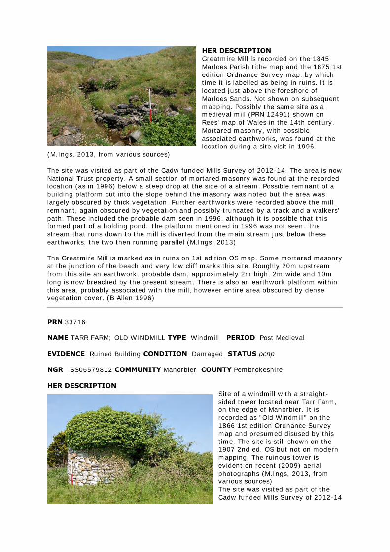
HER DESCRIPTION
Greatmire Mill is recorded on the 1845
Marloes Parish tithe map and the 1875 1st
edition Ordnance Survey map, by which
time it is labelled as being in ruins. It is
located just above the foreshore of
Marloes Sands. Not shown on subsequent
mapping. Possibly the same site as a
medieval mill (PRN 12491) shown on
Rees' map of Wales in the 14th century.
Mortared masonry, with possible
associated earthworks, was found at the
location during a site visit in 1996
(M.Ings, 2013, from various sources)
The site was visited as part of the Cadw funded Mills Survey of 2012-14. The area is now
National Trust property. A small section of mortared masonry was found at the recorded
location (as in 1996) below a steep drop at the side of a stream. Possible remnant of a
building platform cut into the slope behind the masonry was noted but the area was
largely obscured by thick vegetation. Further earthworks were recorded above the mill
remnant, again obscured by vegetation and possibly truncated by a track and a walkers'
path. These included the probable dam seen in 1996, although it is possible that this
formed part of a holding pond. The platform mentioned in 1996 was not seen. The
stream that runs down to the mill is diverted from the main stream just below these
earthworks, the two then running parallel (M.Ings, 2013)
The Greatmire Mill is marked as in ruins on 1st edition OS map. Some mortared masonry
at the junction of the beach and very low cliff marks this site. Roughly 20m upstream
from this site an earthwork, probable dam, approximately 2m high, 2m wide and 10m
long is now breached by the present stream. There is also an earthwork platform within
this area, probably associated with the mill, however entire area obscured by dense
vegetation cover. (B Allen 1996)
PRN 33716
NAME TARR FARM; OLD WINDMILL TYPE Windmill PERIOD Post Medieval
EVIDENCE Ruined Building CONDITION Damaged STATUS pcnp
NGR SS06579812 COMMUNITY Manorbier COUNTY Pembrokeshire
HER DESCRIPTION
Site of a windmill with a straight-
sided tower located near Tarr Farm,
on the edge of Manorbier. It is
recorded as "Old Windmill" on the
1866 1st edition Ordnance Survey
map and presumed disused by this
time. The site is still shown on the
1907 2nd ed. OS but not on modern
mapping. The ruinous tower is
evident on recent (2009) aerial
photographs (M.Ings, 2013, from
various sources)
The site was visited as part of the
Cadw funded Mills Survey of 2012-14
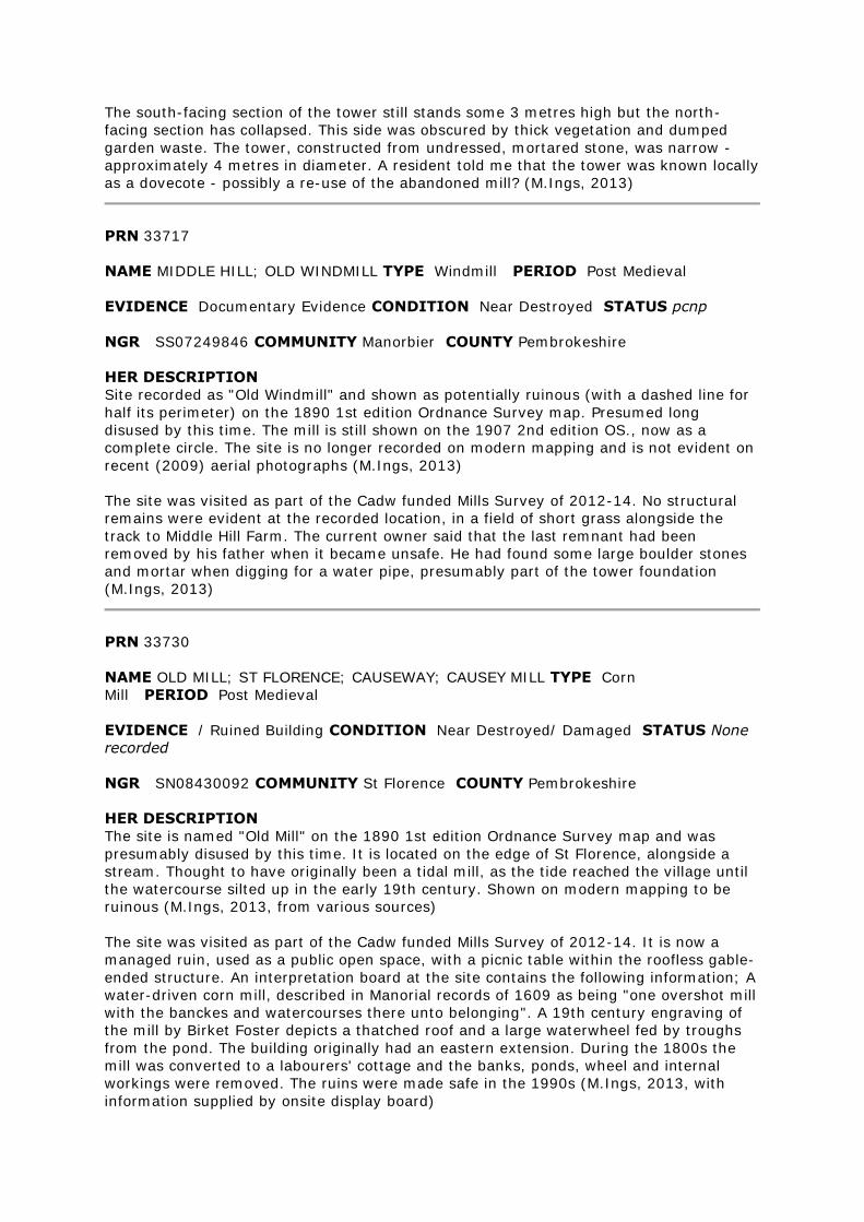
The south-facing section of the tower still stands some 3 metres high but the north-
facing section has collapsed. This side was obscured by thick vegetation and dumped
garden waste. The tower, constructed from undressed, mortared stone, was narrow -
approximately 4 metres in diameter. A resident told me that the tower was known locally
as a dovecote - possibly a re-use of the abandoned mill? (M.Ings, 2013)
PRN 33717
NAME MIDDLE HILL; OLD WINDMILL TYPE Windmill PERIOD Post Medieval
EVIDENCE Documentary Evidence CONDITION Near Destroyed STATUS pcnp
NGR SS07249846 COMMUNITY Manorbier COUNTY Pembrokeshire
HER DESCRIPTION
Site recorded as "Old Windmill" and shown as potentially ruinous (with a dashed line for
half its perimeter) on the 1890 1st edition Ordnance Survey map. Presumed long
disused by this time. The mill is still shown on the 1907 2nd edition OS., now as a
complete circle. The site is no longer recorded on modern mapping and is not evident on
recent (2009) aerial photographs (M.Ings, 2013)
The site was visited as part of the Cadw funded Mills Survey of 2012-14. No structural
remains were evident at the recorded location, in a field of short grass alongside the
track to Middle Hill Farm. The current owner said that the last remnant had been
removed by his father when it became unsafe. He had found some large boulder stones
and mortar when digging for a water pipe, presumably part of the tower foundation
(M.Ings, 2013)
PRN 33730
NAME OLD MILL; ST FLORENCE; CAUSEWAY; CAUSEY MILL TYPE Corn
Mill PERIOD Post Medieval
EVIDENCE / Ruined Building CONDITION Near Destroyed/ Damaged STATUS None
recorded
NGR SN08430092 COMMUNITY St Florence COUNTY Pembrokeshire
HER DESCRIPTION
The site is named "Old Mill" on the 1890 1st edition Ordnance Survey map and was
presumably disused by this time. It is located on the edge of St Florence, alongside a
stream. Thought to have originally been a tidal mill, as the tide reached the village until
the watercourse silted up in the early 19th century. Shown on modern mapping to be
ruinous (M.Ings, 2013, from various sources)
The site was visited as part of the Cadw funded Mills Survey of 2012-14. It is now a
managed ruin, used as a public open space, with a picnic table within the roofless gable-
ended structure. An interpretation board at the site contains the following information; A
water-driven corn mill, described in Manorial records of 1609 as being "one overshot mill
with the banckes and watercourses there unto belonging". A 19th century engraving of
the mill by Birket Foster depicts a thatched roof and a large waterwheel fed by troughs
from the pond. The building originally had an eastern extension. During the 1800s the
mill was converted to a labourers' cottage and the banks, ponds, wheel and internal
workings were removed. The ruins were made safe in the 1990s (M.Ings, 2013, with
information supplied by onsite display board)
PRN 33753
NAME MILTON HOUSE TYPE Carding Mill PERIOD Post Medieval
EVIDENCE Documentary Evidence/ Building CONDITION Not known/
Damaged STATUS None recorded
NGR SN0409703030 COMMUNITY Carew COUNTY Pembrokeshire
HER DESCRIPTION
A carding mill, now ruined, marked on the 1st edition 25" Ordnance Survey map of
1875. It was part of the milling complex centred around the Milton House mill pond, PRN
33754. (RSR April 1999)
The site was visited as part of the Cadw funded Mills Survey of 2012-14. The ruins of the
carding mill were very overgrown and difficult to access, although an information board
had been put up near the site. This explained that the settlement of Milton had existed in
the 14th century, centred around a grist mill, and that two carding mills - involved in the
production of textiles - are recorded here in the reign of Henry VIII. Two carding mills
are also shown on 19th century maps, this one near the mill pond and the other (PRN
7970) near Radford Pill. It is possible that these post-medieval mills have 16th century
origins. The mill ruins comprise a small, square, gable-ended building, with walls
surviving to approximate full height and appear to have been consolidated relatively
recently. The mill pond (PRN 33754), to the south, is preserved as an extensive area of
wetland, under reeds. It was not possible to see how water from the pond was
channelled to power the mill (M.Ings, 2014).
PRN 33754
NAME MILTON HOUSE TYPE Mill Pond PERIOD Post Medieval
EVIDENCE Documentary Evidence/ Earthwork CONDITION Not known/ Near
Intact STATUS None recorded
NGR SN04100300 COMMUNITY Carew COUNTY Pembrokeshire
HER DESCRIPTION
An extensive mill pond with leats running from it to the grist mill, PRN 7971, and carding
mills, PRN's 7970 & 33753, marked on the 1st edition 25" OS map of 1875. (RSR April
1999)
The site was seen as part of the Cadw funded Mills Survey of 2012-14. The area of the
pond is preserved, although now obscured by reeds (M.Ings, 2014)
PRN 33845
NAME MILLIN MILL TYPE Corn Mill PERIOD Post Medieval
EVIDENCE Building CONDITION Near Destroyed STATUS pcnp
NGR SM99421416 COMMUNITY Uzmaston and Boulston COUNTY Pembrokeshire
HER DESCRIPTION
A ruined corn mill depicted on the 1st and 2nd edition Ordnance Survey maps as Millin
Mill (Disused). The mill takes the form of a three cell rectangular structure with a small
enclosure to the rear. It was fed by a mill race onto its eastern, long side which
presumably supported a water wheel in a wheel pit. There are documentary references
to a medieval water mill at Millin which may relate to the remains at this PRN. The
footprint of the mill building and the line of the mill race are shown on the most recent
Ordnance Survey mapping (Mastermap 2011) The most recent Aerial photographs (Next
Perspectives 2009) show the area of the mill and mill race to be under woodland.
The site was visited as part of the Cadw funded Mills Survey of 2012-14. It is located
within thick woodland on the slope above Millin Brook. Only a section of the northeast
wall of the mill, standing approximately one metre high, was evident, although further
structural remains may have been obscured by the dense vegetation. The building
platform could still be discerned, built into the hillslope, with a vertiginous stone-
revetted drop to the northeast of the mill. This is the location of the wheel pit that would
have contained an overshot wheel. Above this is the area of the mill pond, now a dry,
silted and vegetated earthwork, lined, at least partially with stone. The mill race (PRN
17780) feeds into the pond from the north. The tail race is preserved as an earthwork
running. alongside the north and west sides of the building platform (M.Ings, 2013)
PRN 34481
NAME LOWER RICKESTON MILL TYPE Mill/ Flour Mill PERIOD Post Medieval/ Post-
Medieval
EVIDENCE Building CONDITION Destroyed/ Near Destroyed STATUS pcnp
NGR SM8657209008 COMMUNITY Walwyn's Castle COUNTY Pembrokeshire
HER DESCRIPTION
Lower Rickeston flour mill is recorded on the 1876 1st edition Ordnance Survey map
powered by a mill race diverted from Sandyhaven Pill to the north and the buildings are
still shown on the 1908 2nd edition, although no longer labelled. The site is not shown
on modern maps (M.Ings, 2014)
The site was visited as part of the Cadw funded Mills Survey of 2012-14. The area is
under rough grazing with patches of scrub. No evidence was found for structural remains
or earthworks associated with the mill (M.Ings, 2014) Lower Rickeston Mill (flour)
identified from 1st Edition Ordnance Survey map. There are two mills in the locality,
Upper and Lower Rickeston. No evidence of this mill in the area (BA & KM 1997)
PRN 34482
NAME LOWER RICKESTON TYPE Mill Pond PERIOD Post Medieval
EVIDENCE Earthwork CONDITION Not Known STATUS pcnp
NGR SM86600910 COMMUNITY Walwyn's Castle COUNTY Pembrokeshire
HER DESCRIPTION
Mill pond identified from 1st Edition OS, there are two mills in the locality Upper and
Lower Rickeston, this mill pond would have served Lower Rickeston Mill, PRN 34481. Not
seen during fieldwork. BA & KM 1997
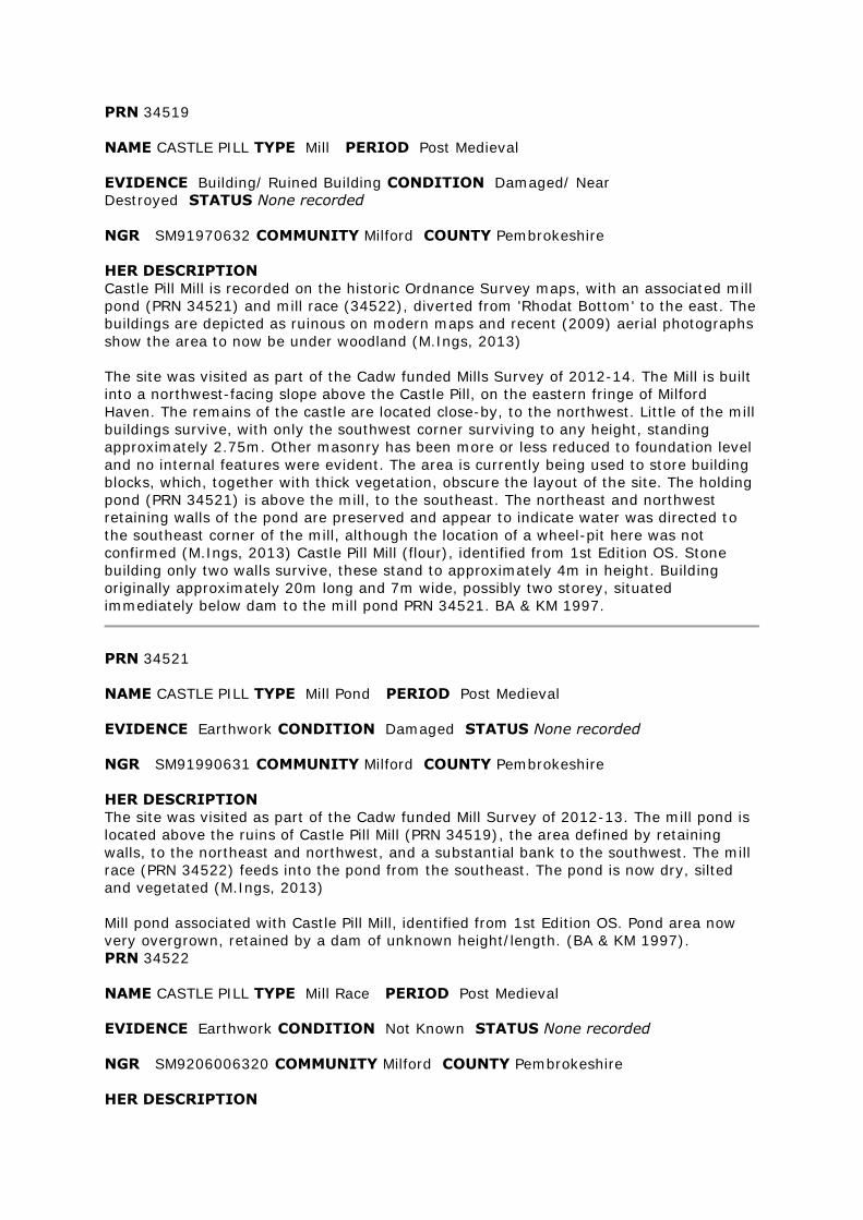
PRN 34519
NAME CASTLE PILL TYPE Mill PERIOD Post Medieval
EVIDENCE Building/ Ruined Building CONDITION Damaged/ Near
Destroyed STATUS None recorded
NGR SM91970632 COMMUNITY Milford COUNTY Pembrokeshire
HER DESCRIPTION
Castle Pill Mill is recorded on the historic Ordnance Survey maps, with an associated mill
pond (PRN 34521) and mill race (34522), diverted from 'Rhodat Bottom' to the east. The
buildings are depicted as ruinous on modern maps and recent (2009) aerial photographs
show the area to now be under woodland (M.Ings, 2013)
The site was visited as part of the Cadw funded Mills Survey of 2012-14. The Mill is built
into a northwest-facing slope above the Castle Pill, on the eastern fringe of Milford
Haven. The remains of the castle are located close-by, to the northwest. Little of the mill
buildings survive, with only the southwest corner surviving to any height, standing
approximately 2.75m. Other masonry has been more or less reduced to foundation level
and no internal features were evident. The area is currently being used to store building
blocks, which, together with thick vegetation, obscure the layout of the site. The holding
pond (PRN 34521) is above the mill, to the southeast. The northeast and northwest
retaining walls of the pond are preserved and appear to indicate water was directed to
the southeast corner of the mill, although the location of a wheel-pit here was not
confirmed (M.Ings, 2013) Castle Pill Mill (flour), identified from 1st Edition OS. Stone
building only two walls survive, these stand to approximately 4m in height. Building
originally approximately 20m long and 7m wide, possibly two storey, situated
immediately below dam to the mill pond PRN 34521. BA & KM 1997.
PRN 34521
NAME CASTLE PILL TYPE Mill Pond PERIOD Post Medieval
EVIDENCE Earthwork CONDITION Damaged STATUS None recorded
NGR SM91990631 COMMUNITY Milford COUNTY Pembrokeshire
HER DESCRIPTION
The site was visited as part of the Cadw funded Mill Survey of 2012-13. The mill pond is
located above the ruins of Castle Pill Mill (PRN 34519), the area defined by retaining
walls, to the northeast and northwest, and a substantial bank to the southwest. The mill
race (PRN 34522) feeds into the pond from the southeast. The pond is now dry, silted
and vegetated (M.Ings, 2013)
Mill pond associated with Castle Pill Mill, identified from 1st Edition OS. Pond area now
very overgrown, retained by a dam of unknown height/length. (BA & KM 1997).
PRN 34522
NAME CASTLE PILL TYPE Mill Race PERIOD Post Medieval
EVIDENCE Earthwork CONDITION Not Known STATUS None recorded
NGR SM9206006320 COMMUNITY Milford COUNTY Pembrokeshire
HER DESCRIPTION
Mill race recorded on the historic Ordnance Survey maps, diverted from Rhodal Bottom
to power Castle Pill Mill (PRN 34519) No longer shown on modern maps (M.Ings, 2013)
The site was visited as part of the Cadw funded Mills Survey of 2012-13. The leat was
noted where it opened out into holding pond (PRN 34521) but could not be traced back
due to thick vegetation (M.Ings, 2013)
Mill leat associated with Castle Pill Mill, identified from 1st Edition OS. Leat not seen due
to dense vegetation. (BA & KM 1997).
PRN 34551
NAME WESTFIELD PILL TYPE Mill Pond PERIOD Post Medieval
EVIDENCE Earthwork CONDITION Near Intact STATUS None recorded
NGR SM96190733 COMMUNITY Rosemarket COUNTY Pembrokeshire
HER DESCRIPTION
Mill pond associated with Westfield corn mill (PRN 17845) and recorded on the 1885 1st
edition Ordnance Survey map (M.Ings, 2014)
The site was visited as part of the Cadw funded Mills Survey of 2012-14. The elongated
mill pond is now dry and preserved as a large vertically-sided, stone-lined recess. There
is a metal-grilled sluice gate set into the pond wall where it empties into the channel
feeding into the wheel-pit (M.Ings, 2014)
Mill pond identified from 1st Edition OS. Linear pond retained by long dam alongside pill.
Dam seems to be built of clinker/ash from railway and faced with concrete. Some sluice
gates survive on this dam. (BA & KM, 1997)
PRN 34552
NAME WESTFIELD PILL TYPE Leat PERIOD Post Medieval
EVIDENCE Earthwork CONDITION Near Intact STATUS None recorded
NGR SM96050742 COMMUNITY Rosemarket COUNTY Pembrokeshire
HER DESCRIPTION
Mill race feeding into mill pond (PRN 34551) associated with Westfield corn mill (PRN
17845). Recorded on 1885 1st edition Ordnance Survey map (M.Ings, 2014)
The site was seen as part of the Cadw funded Mills Survey of 2012-14. It is stone-lined
as it enters the mill pond (PRN 34551) to the north and could be traced through the
woodland as a silted, vegetated earthwork that still functions, in part, as a drain (M.Ings,
2014)
Leat identified from 1st Edition OS. Leat feeding pond PRN 34551. Now very overgrown
and unused. Retained by an earth bank.(BA & KM 1997)
PRN 34614
NAME LAMBEETH MILL; COCHESTON PILL TYPE Mill/ Cottage PERIOD Post
Medieval/ Post-Medieval
EVIDENCE Building CONDITION Damaged STATUS None recorded
NGR SM9384801432 COMMUNITY Angle COUNTY Pembrokeshire
HER DESCRIPTION
Lambeeth Mill is recorded on the 1875 1st edition and 1908 2nd edition Ordnance
Survey maps. The building is shown to be ruinous on modern maps (M.Ings, 2014)
The site was visited as part of the Cadw funded Mills Survey of 2012-14. The mill was
not found. There was a ruinous cottage by the side of the public footpath, possibly as
seen in 1997 although that was said to be in dense woodland, and a substantial modern
structure that looked like a possible limekiln (M.Ings, 2014).
Lambeeth Mill was identified from 1st Edition OS. This mill building is in dense woodland
and it is not possible to identify any features associated with the mill. The mill is stone
built as one and a half storeys with chimney gables. Now roofless but with the walls still
standing to full height. From what can be seen the building has more of an appearance
of a cottage than a mill. BA & KM 1997
PRN 35603
NAME PEN FELIN-WYNT TYPE Windmill PERIOD Post Medieval
EVIDENCE Structure CONDITION Not Known STATUS Pembrokeshire Coast National
Park
NGR SN07982976 COMMUNITY Maenclochog COUNTY Pembrokeshire
HER DESCRIPTION
Recorded as a windmill on the 1889 1st Edition Ordnance Survey, it was possibly used to
pump water at Rosebush quarry. It is not shown on later mapping.and the area is now a
forestry plantation (M.Ings, 2012, from various sources)
A circular feature can be seen on the 1955 Meridian Airmaps aerial photograph (JH,
1998)
PRN 38771
NAME OLD MILL TYPE Mill PERIOD Post Medieval
EVIDENCE Documentary Evidence/ Demolished Building CONDITION Not known/
Near Destroyed STATUS pcnp
NGR SN01510853 COMMUNITY Martletwy COUNTY Pembrokeshire
HER DESCRIPTION
A building marked on the 1st Edition 6" OS map and labelled as Old Mill, but omitted
from later editions (RSR August 1999) A ruinous building is still shown on the 1908 2nd
edition OS. and modern maps (M.Ings, 2014)
The site was visited as part of the Cadw funded Mills Survey of 2012-14. The location is
a steeply sided stream valley under dense woodland. No structural remains were
evident, although they could easily have been obscured by the thick vegetation. A local
resident told me that he believed the building to now be destroyed (M.Ings, 2014).
Not visited because inaccessible (DS February 2000)
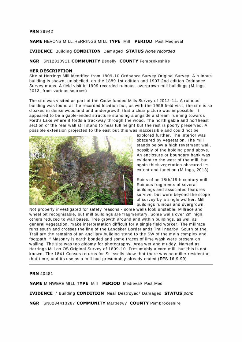
PRN 38942
NAME HERONS MILL;HERRINGS MILL TYPE Mill PERIOD Post Medieval
EVIDENCE Building CONDITION Damaged STATUS None recorded
NGR SN12310911 COMMUNITY Begelly COUNTY Pembrokeshire
HER DESCRIPTION
Site of Herrings Mill identified from 1809-10 Ordnance Survey Original Survey. A ruinous
building is shown, unlabelled, on the 1889 1st edition and 1907 2nd edition Ordnance
Survey maps. A field visit in 1999 recorded ruinous, overgrown mill buildings (M.Ings,
2013, from various sources)
The site was visited as part of the Cadw funded Mills Survey of 2012-14. A ruinous
building was found at the recorded location but, as with the 1999 field visit, the site is so
cloaked in dense woodland and undergrowth that a clear picture was impossible. It
appeared to be a gable-ended structure standing alongside a stream running towards
Ford's Lake where it fords a trackway through the wood. The north gable and northeast
section of the rear wall still stand to near full height but the rest is poorly preserved. A
possible extension projected to the east but this was inaccessible and could not be
explored further. The interior was
obscured by vegetation. The mill
stands below a high revetment wall,
possibly of the holding pond above.
An enclosure or boundary bank was
evident to the west of the mill, but
again thick vegetation obscured its
extent and function (M.Ings, 2013)
Ruins of an 18th/19th century mill.
Ruinous fragments of several
buildings and associated features
survive, but were beyond the scope
of survey by a single worker. Mill
buildings ruinous and overgrown.
Not properly investigated for safety reasons - some walls look unstable. Millrace and
wheel pit recognisable, but mill buildings are fragmentary. Some walls over 2m high,
others reduced to wall bases. Tree growth around and within buildings, as well as
general vegetation, make interpretation difficult for a single field worker. The millrace
runs south and crosses the line of the Landsker Borderlands Trail nearby. South of the
Trail are the remains of an ancillary building stand to the SW of the main complex and
footpath. ^Masonry is earth bonded and some traces of lime wash were present on
walling. The site was too gloomy for photography. Area wet and muddy. Named as
Herrings Mill on OS Original Survey of 1809-10. Presumably a corn mill, but this is not
known. The 1841 Census returns for St Issells show that there was no miller resident at
that time, and its use as a mill had presumably already ended (RPS 16.9.99)
PRN 40481
NAME MINWERE MILL TYPE Mill PERIOD Medieval/ Post Med
EVIDENCE / Building CONDITION Near Destroyed/ Damaged STATUS pcnp
NGR SN0284413287 COMMUNITY Martletwy COUNTY Pembrokeshire
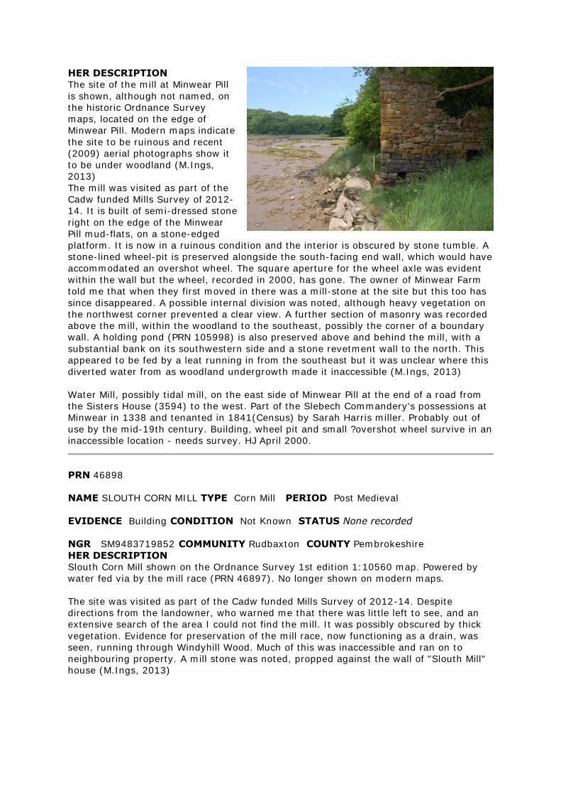
HER DESCRIPTION
The site of the mill at Minwear Pill
is shown, although not named, on
the historic Ordnance Survey
maps, located on the edge of
Minwear Pill. Modern maps indicate
the site to be ruinous and recent
(2009) aerial photographs show it
to be under woodland (M.Ings,
2013)
The mill was visited as part of the
Cadw funded Mills Survey of 2012-
14. It is built of semi-dressed stone
right on the edge of the Minwear
Pill mud-flats, on a stone-edged
platform. It is now in a ruinous condition and the interior is obscured by stone tumble. A
stone-lined wheel-pit is preserved alongside the south-facing end wall, which would have
accommodated an overshot wheel. The square aperture for the wheel axle was evident
within the wall but the wheel, recorded in 2000, has gone. The owner of Minwear Farm
told me that when they first moved in there was a mill-stone at the site but this too has
since disappeared. A possible internal division was noted, although heavy vegetation on
the northwest corner prevented a clear view. A further section of masonry was recorded
above the mill, within the woodland to the southeast, possibly the corner of a boundary
wall. A holding pond (PRN 105998) is also preserved above and behind the mill, with a
substantial bank on its southwestern side and a stone revetment wall to the north. This
appeared to be fed by a leat running in from the southeast but it was unclear where this
diverted water from as woodland undergrowth made it inaccessible (M.Ings, 2013)
Water Mill, possibly tidal mill, on the east side of Minwear Pill at the end of a road from
the Sisters House (3594) to the west. Part of the Slebech Commandery's possessions at
Minwear in 1338 and tenanted in 1841(Census) by Sarah Harris miller. Probably out of
use by the mid-19th century. Building, wheel pit and small ?overshot wheel survive in an
inaccessible location - needs survey. HJ April 2000.
PRN 46898
NAME SLOUTH CORN MILL TYPE Corn Mill PERIOD Post Medieval
EVIDENCE Building CONDITION Not Known STATUS None recorded
NGR SM9483719852 COMMUNITY Rudbaxton COUNTY Pembrokeshire
HER DESCRIPTION
Slouth Corn Mill shown on the Ordnance Survey 1st edition 1:10560 map. Powered by
water fed via by the mill race (PRN 46897). No longer shown on modern maps.
The site was visited as part of the Cadw funded Mills Survey of 2012-14. Despite
directions from the landowner, who warned me that there was little left to see, and an
extensive search of the area I could not find the mill. It was possibly obscured by thick
vegetation. Evidence for preservation of the mill race, now functioning as a drain, was
seen, running through Windyhill Wood. Much of this was inaccessible and ran on to
neighbouring property. A mill stone was noted, propped against the wall of "Slouth Mill"
house (M.Ings, 2013)
PRN 58770
NAME LLWYNGWAIR MILL,A487 (CARDIGAN ROAD) TYPE Water Mill PERIOD Post
Medieval
EVIDENCE Building CONDITION Near Intact STATUS listed building 12525 II/
pcnp
NGR SN0696739247 COMMUNITY Newport COUNTY Pembrokeshire
HER DESCRIPTION
A substantial Grade II Listed water mill built in the early - mid 19th century.It has an
iron and timber overshot waterwheel stamp-dated 1843. The historic Ordnance Survey
maps depict an attendant mill stream and mill pond and modern mapping suggests that
these features remain preserved (M.Ings, 2012, from various sources).
PRN 59160
NAME VELINDRE WATER MILL,VELINDRE,LLANWNDA TYPE Water Mill PERIOD Post
Medieval
EVIDENCE Building CONDITION Restored STATUS listed building 13007 II/ pcnp
NGR SM8948836135 COMMUNITY Pencaer COUNTY Pembrokeshire
HER DESCRIPTION
A grade II listed water mill built in 1798, which incorporated an overshot wheel that
drove two pairs of stones and powered a threshing machine in a nearby barn. The mill
was restored in 1990 (M.Ings, 2012, from various sources)
Rees's map (1932) of Wales in the 14th century suggests that a mill (PRN 12481)
predated the 18th century building. Fabric from this could possibly have been
incorporated into the later mill (M.Ings, 2012)
PRN 103349
NAME TREWENT MILL TYPE Mill Pond PERIOD Post Medieval
EVIDENCE Earthwork CONDITION Not known STATUS None recorded
NGR SS00969779 COMMUNITY Lamphey COUNTY Pembrokeshire
HER DESCRIPTION
Mill pond associated with Trewent corn mill (PRN 103350), fed by mill race (PRN
103348). Recorded on the 1865 1st edition Ordnance Survey map but not shown on
subsequent mapping and now within woodland (M.Ings, 2012)
PRN 103350
NAME TREWENT MILL TYPE Corn Mill PERIOD Post Medieval
EVIDENCE Documentary Evidence CONDITION Not known STATUS None recorded
NGR SS00989776 COMMUNITY Lamphey COUNTY Pembrokeshire
HER DESCRIPTION
Trewent corn mill is recorded on the 1809 Ordnance Survey original surveyors drawings.
It is shown to comprise three buildings on the 1865 1st edition Ordnance Survey but is
gone by the 1908 2nd ed. OS. Associated features include mill-race (PRN 103348), mill-
pond (PRN 103349) and tail-race (PRN 103351) The site of the mill building is now
within woodland (M.Ings, 2012)
The site was visited as part of the Cadw funded Mills Survey of 2012-14. Unfortunately,
the steep-sided woodland valley in which the mill is now located proved inaccessible. A
stone dam, with sluice opening, was encountered to the south of the mill location but it
is not thought to form part of the mill complex, which was powered from the northwest.
Access to the fields above and to the west of the mill was also not possible, with none of
the local residents sure who actually owned the land. Therefore, the possible
preservation of the mill pond, dam (PRN 103349) and race (PRN 103348) could not be
assessed (M.Ings, 2013)
PRN 103351
NAME TREWENT MILL TYPE Mill Race PERIOD Post Medieval
EVIDENCE Earthwork CONDITION Not known STATUS None recorded
NGR SS01049782 COMMUNITY Lamphey COUNTY Pembrokeshire
HER DESCRIPTION
Tail-race associated with Trewent corn mill (PRN 103350) recorded on the 1865 1st
edition Ordnance Survey map but not shown on subsequent maps. Visible, in part, on
modern aerial photograph (M.Ings, 2012)
PRN 103362
NAME FLEMINGTON MILL TYPE Mill PERIOD Post Medieval
EVIDENCE Documentary Evidence/ Ruined Building CONDITION Not known/ Damaged
STATUS None recorded
NGR SN05070212 COMMUNITY Carew COUNTY Pembrokeshire
HER DESCRIPTION
Site of Flemington Mill recorded on the 1865 1st edition Ordnance Survey map. It is
shown in outline only on the 1907 2nd ed. OS. and is now ruinous (M.Ings, 2012)
The site was visited as part of the Cadw funded Mills Survey of 2012-14. It is located
within woodland to the southeast of Carew. The mill building is ruinous, with the
southwest-facing wall completely collapsed. It is built against a steep bank to the
southeast and the best preserved wall, the northwest-facing gable standing some 1.75m
high, is built against a substantial earthwork bank to the northwest. The mill appeared to
be divided into two rooms, although little remains of the internal dividing wall and no
internal features could be discerned, the whole being obscured by stone tumble and
vegetation. A possible wheel-pit is adjacent to the northeast-facing side wall, with a leat
feeding into it above the southeast corner of the mill. The wheel-pit and tail-race are
preserved as well-defined earthworks. The leat, diverted from the stream to the east,
was evident as a silted, dry earthwork close to the mill but could not be traced back far
because of the thick vegetation. A second building was recorded to the southwest. Again
ruinous, there were no features to denote its possible function apart from a ventilation
loop in one side wall, suggesting agricultural use (M.Ings, 2013)
PRN 105989
NAME CARN MILL TYPE Mill PERIOD Post-Medieval
EVIDENCE Ruined Building CONDITION Near Destroyed STATUS None recorded
NGR SN0813310931 COMMUNITY Jeffreyston COUNTY Pembrokeshire
HER DESCRIPTION
Carn Mill is recorded on the 1809 Ordnance Survey original surveyors drawings and
shown as disused by the time of the 1889 1st edition Ordnance Survey map. This map
depicts a possible mill pond just to the north of the building, fed by a mill stream
diverted from Loveston Lake to the northeast. The building is shown as possibly ruinous
on the 2nd ed. OS. and modern maps (M.Ings, 2014)
The site was visited as part of the Cadw funded Mills Survey of 2012-14. It is located
within the wooded Loveston Lake stream valley. The building is now ruinous, with the
surviving walls standing less than a metre high, while the southern end wall has all but
gone. It is built into the hillslope, with the north end wall of the building extended on
either side to act as a revetment. A low arched aperture was evident within the west-
facing wall but it is uncertain whether or not this is where the waterwheel was attached.
The site is very overgrown and trees now grow within the walls. A holding pond is
preserved as a dry, vegetated earthwork above the ruins, although its edges are
obscured by thick undergrowth. Similarly, the line of the mill stream, entering the pond
from the east, can be discerned but thick vegetation prevented a clear look (M.Ings,
2014).
PRN 105990
NAME FELIN-FACH-GANOL TYPE Cottage PERIOD Post-Medieval
EVIDENCE Ruined Building CONDITION Near Destroyed STATUS None recorded
NGR SN13133543 COMMUNITY Eglwyswrw COUNTY Pembrokeshire
HER DESCRIPTION
Felin-fach ganol is recorded on the 1889 1st edition and 1907 2nd ed. Ordnance Survey
Survey maps. The name indicates a possible mill site. The building shown on modern
maps to be ruinous (M.Ings, 2014)
The site was visited as part of the Cadw funded Mills Survey of 2012-14. The building
was evidently a cottage, now in a highly ruinous state. A fireplace survives in the north-
facing gable but the walls are now generally reduced to less than one metre in height. It
is now within an area of woodland and the site is very overgrown. It is located just to the
north of another cottage, Felin-fach-uchaf (PRN 19075) (M.Ings, 2014)
PRN 105991
NAME MELIN BRYN-Y-BERION; BRYN-BERIAN MILL TYPE Mill Race PERIOD Post-
Medieval
EVIDENCE Earthwork CONDITION Near Intact STATUS None recorded
NGR SN1053335142 COMMUNITY Eglwyswrw COUNTY Pembrokeshire
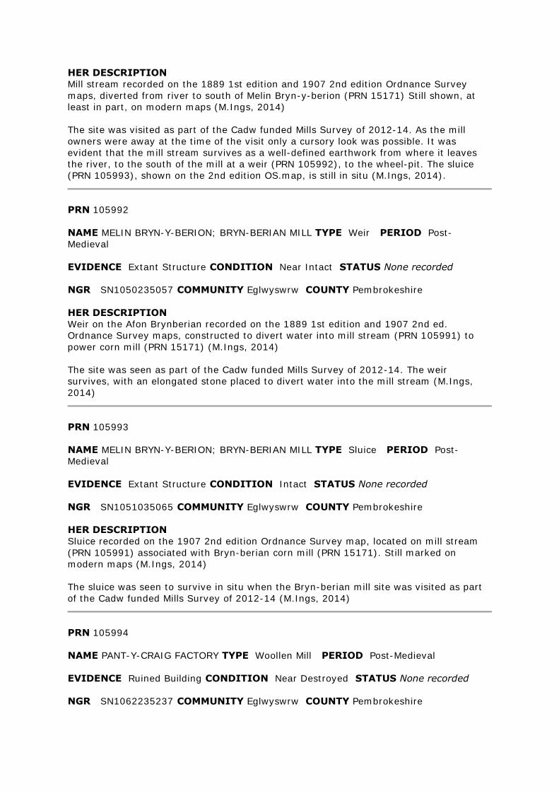
HER DESCRIPTION
Mill stream recorded on the 1889 1st edition and 1907 2nd edition Ordnance Survey
maps, diverted from river to south of Melin Bryn-y-berion (PRN 15171) Still shown, at
least in part, on modern maps (M.Ings, 2014)
The site was visited as part of the Cadw funded Mills Survey of 2012-14. As the mill
owners were away at the time of the visit only a cursory look was possible. It was
evident that the mill stream survives as a well-defined earthwork from where it leaves
the river, to the south of the mill at a weir (PRN 105992), to the wheel-pit. The sluice
(PRN 105993), shown on the 2nd edition OS.map, is still in situ (M.Ings, 2014).
PRN 105992
NAME MELIN BRYN-Y-BERION; BRYN-BERIAN MILL TYPE Weir PERIOD Post-
Medieval
EVIDENCE Extant Structure CONDITION Near Intact STATUS None recorded
NGR SN1050235057 COMMUNITY Eglwyswrw COUNTY Pembrokeshire
HER DESCRIPTION
Weir on the Afon Brynberian recorded on the 1889 1st edition and 1907 2nd ed.
Ordnance Survey maps, constructed to divert water into mill stream (PRN 105991) to
power corn mill (PRN 15171) (M.Ings, 2014)
The site was seen as part of the Cadw funded Mills Survey of 2012-14. The weir
survives, with an elongated stone placed to divert water into the mill stream (M.Ings,
2014)
PRN 105993
NAME MELIN BRYN-Y-BERION; BRYN-BERIAN MILL TYPE Sluice PERIOD Post-
Medieval
EVIDENCE Extant Structure CONDITION Intact STATUS None recorded
NGR SN1051035065 COMMUNITY Eglwyswrw COUNTY Pembrokeshire
HER DESCRIPTION
Sluice recorded on the 1907 2nd edition Ordnance Survey map, located on mill stream
(PRN 105991) associated with Bryn-berian corn mill (PRN 15171). Still marked on
modern maps (M.Ings, 2014)
The sluice was seen to survive in situ when the Bryn-berian mill site was visited as part
of the Cadw funded Mills Survey of 2012-14 (M.Ings, 2014)
PRN 105994
NAME PANT-Y-CRAIG FACTORY TYPE Woollen Mill PERIOD Post-Medieval
EVIDENCE Ruined Building CONDITION Near Destroyed STATUS None recorded
NGR SN1062235237 COMMUNITY Eglwyswrw COUNTY Pembrokeshire
HER DESCRIPTION
Mill associated with Woollen Factory (PRN 19099) recorded on the 1889 1st edition and
1907 2nd ed. Ordnance Survey maps. Located on the bank of the Afon Brynberian. Not
shown on modern maps, presumed destroyed (M.Ings, 2014)
The mill was seen as part of the Cadw funded Mills Survey of 2012-14. Little now
remains, with just the southeast corner of the building surviving, pointing out towards
the river. It is built of stone rubble and a substantial stone lintel, low on the southwest-
facing wall, could be the aperture for a wheel axle (M.Ings, 2014).
PRN 105995
NAME PWLL MILL TYPE Corn Mill PERIOD Post-Medieval
EVIDENCE Ruined Building CONDITION Damaged STATUS None recorded
NGR SN07423883 COMMUNITY Nevern COUNTY Pembrokeshire
HER DESCRIPTION
The mill buildings are shown, although not labelled, on the 1889 1st edition and 1907
2nd ed. Ordnance Survey maps.
Recorded by the RCAHMW as a corn
mill. Buildings appear to be roofless by
at least 1907 and are shown as ruinous
on modern maps (M.Ings, 2014)
The site was seen as part of the Cadw
funded Mills Survey of 2012-14. There
are three ruinous buildings, with the
mill building standing to the southeast
of a possible cottage and outbuilding.
The footprint of the mill survives, with
walls standing approximately 1m to
1.3m high although the north-facing
end wall has largely collapsed. The
interior is now obscured by stone
tumble. There is a low, arched aperture in the centre of the south-facing end wall which
possibly accommodated the waterwheel axle. The wheel-pit, now dry, silted and
vegetated, is located alongside this elevation, fed by a leat running from the west. The
mill race is preserved, at least in part, as a dry earthwork, with a bank on its northern
side, but could not be followed far as it is fenced off. The tail race survives as a distinct
channel crossing the pasture field to the northeast of the mill, returning to the stream. A
pair of mill stones are stacked against the corner of the cottage (M.Ings, 2014)
PRN 105996
NAME LOWER SOLVA TYPE Corn Mill PERIOD Post-Medieval
EVIDENCE Demolished Building CONDITION Near Destroyed STATUS None
recorded
NGR SM80712450 COMMUNITY Solva COUNTY Pembrokeshire
HER DESCRIPTION
Site of a post-medieval corn mill, with possible medieval origins,shown on the 1889 1st
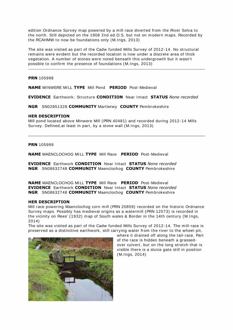
edition Ordnance Survey map powered by a mill race diverted from the River Solva to
the north. Still depicted on the 1908 2nd ed.O.S. but not on modern maps. Recorded by
the RCAHMW to now be foundations only (M.Ings, 2013)
The site was visited as part of the Cadw funded Mills Survey of 2012-14. No structural
remains were evident but the recorded location is now under a discrete area of thick
vegetation. A number of stones were noted beneath this undergrowth but it wasn't
possible to confirm the presence of foundations (M.Ings, 2013)
PRN 105998
NAME MINWERE MILL TYPE Mill Pond PERIOD Post-Medieval
EVIDENCE Earthwork; Structure CONDITION Near Intact STATUS None recorded
NGR SN02851328 COMMUNITY Martletwy COUNTY Pembrokeshire
HER DESCRIPTION
Mill pond located above Minwere Mill (PRN 40481) and recorded during 2012-14 Mills
Survey. Defined,at least in part, by a stone wall (M.Ings, 2013)
PRN 105999
NAME MAENCLOCHOG MILL TYPE Mill Race PERIOD Post-Medieval
EVIDENCE Earthwork CONDITION Near Intact STATUS None recorded
NGR SN08632748 COMMUNITY Maenclochog COUNTY Pembrokeshire
NAME MAENCLOCHOG MILL TYPE Mill Race PERIOD Post-Medieval
EVIDENCE Earthwork CONDITION Near Intact STATUS None recorded
NGR SN08632748 COMMUNITY Maenclochog COUNTY Pembrokeshire
HER DESCRIPTION
Mill race powering Maenclochog corn mill (PRN 20859) recorded on the historic Ordnance
Survey maps. Possibly has medieval origins as a watermill (PRN 12573) is recorded in
the vicinity on Rees' (1932) map of South wales & Border in the 14th century (M.Ings,
2014)
The site was visited as part of the Cadw funded Mills Survey of 2012-14. The mill-race is
preserved as a distinctive earthwork, still carrying water from the river to the wheel-pit,
where it drained off along the tail-race. Part
of the race is hidden beneath a grassed-
over culvert, but on the long stretch that is
visible there is a sluice gate still in position
(M.Ings, 2014)
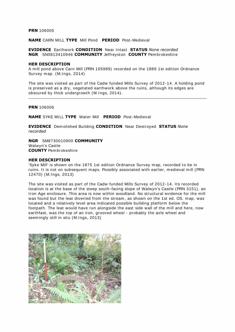
PRN 106005
NAME CARN MILL TYPE Mill Pond PERIOD Post-Medieval
EVIDENCE Earthwork CONDITION Near Intact STATUS None recorded
NGR SN0813410946 COMMUNITY Jeffreyston COUNTY Pembrokeshire
HER DESCRIPTION
A mill pond above Carn Mill (PRN 105989) recorded on the 1889 1st edition Ordnance
Survey map. (M.Ings, 2014)
The site was visited as part of the Cadw funded Mills Survey of 2012-14. A holding pond
is preserved as a dry, vegetated earthwork above the ruins, although its edges are
obscured by thick undergrowth (M.Ings, 2014).
PRN 106006
NAME SYKE MILL TYPE Water Mill PERIOD Post-Medieval
EVIDENCE Demolished Building CONDITION Near Destroyed STATUS None
recorded
NGR SM8730010900 COMMUNITY
Walwyn's Castle
COUNTY Pembrokeshire
HER DESCRIPTION
'Syke Mill' is shown on the 1875 1st edition Ordnance Survey map, recorded to be in
ruins. It is not on subsequent maps. Possibly associated with earlier, medieval mill (PRN
12470) (M.Ings, 2013)
The site was visited as part of the Cadw funded Mills Survey of 2012-14. Its recorded
location is at the base of the steep south-facing slope of Walwyn's Castle (PRN 3151), an
Iron Age enclosure. This area is now within woodland. No structural evidence for the mill
was found but the leat diverted from the stream, as shown on the 1st ed. OS. map, was
located and a relatively level area indicated possible building platform below the
footpath. The leat would have run alongside the east side wall of the mill and here, now
earthfast, was the top of an iron, grooved wheel - probably the axle wheel and
seemingly still in situ (M.Ings, 2013)

RHIF YR ADRODDIAD / REPORT NUMBER 2014/7
Mawth 2014
March 2014
Paratowyd yr adroddiad hwn gan / This report has been prepared by Mike.Ings
Swydd / Position: Heritage Archaeologist
Llofnod / Signature . Dyddiad / Date 27/03/2014
Mae’r adroddiad hwn wedi ei gael yn gywir a derbyn sêl bendith
This report has been checked and approved by Ken Murphy
ar ran Ymddiriedolaeth Archaeolegol Dyfed Cyf.
on behalf of Dyfed Archaeological Trust Ltd.
Swydd / Position: Trust Director
Llofnod / Signature .Dyddiad / Date 27/03/2014
As part of our desire to provide a quality service we would welcome any comments you
may have on the content or presentation of this report
MEDIEVAL AND EARLY POST-MEDIEVAL MILLS A THREAT-RELATED ASSESSMENT 2012 -14
Recommended