Mapping Crashes in the State of Alabama: An Effort Integrating Route Mile-Post and Node-
Link-Offset Methodologies
University of Alabama
Randy K. Smith University of Alabama, Center for Advanced Public Safety
T. Beau Elliott Randy K. Smith
Andrew J. Graettinger The University of Alabama
Timothy Barnett Waymon Benifield Jennifer Bleiholder
Samuel Poole Alabama Department of Transportation
Dana A. Steil Harding University

Alabama Crash Statistics 2006 2007 2008 2009 2010 2011
Fatalities 1,208 1,110 967 849 862 899 Crashes 139,800 135,300 124,000 123,731 128,348 127,685
*
• SHSP 2.0, released February 2012 • 2011 Fatalities include Private Property
* • ~68K Road miles • ~28K State maintained • ~40K approximately
evenly split between cities and counties

Crash Locating in Alabama • Route and Milepost
– On-System Crashes – 5 year average ~48% – Map-able
• But not in municipals
• Node-Link-Offset – Off System Crashes – 5 year average ~52%
• 34% municipals, 18% county
– Not map-able

Node-Link-Offset • Officer in the field
looks up “location” on PDF drawings of Node-Link Maps

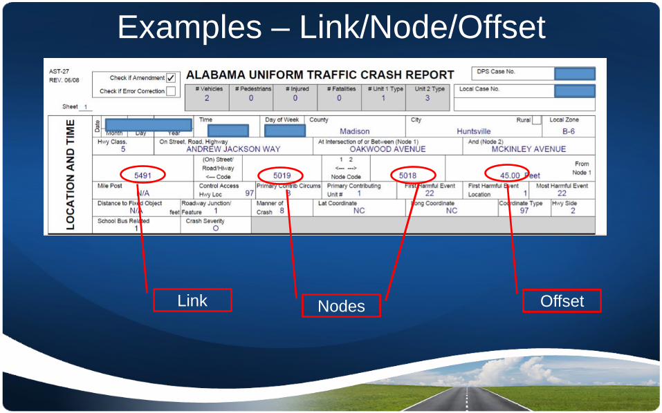
Examples – Link/Node/Offset
Link Offset Nodes

Examples - Intersection
Link Offset Nodes

Drawings Node and Links • Hundreds of PDFs and drawings
maintained by DOT • Hundreds of PDFs needed by a
State Trooper • Granularity is an issue • Not able to map node/link/offset

Goal • Be able to map and analyze ALL crashes • Start with getting nodes located for all State/Federal routes
including routes through municipals – Every node has a Route/Milepost and a coordinate – Route/Milepost HotSpot analysis through municipals
• Previously stopped at municipal limits
• Use experience learned from State routes to tackle off-system crashes
• Add link labels for every link in the state – Start with State routes – Use experience learned to manage local
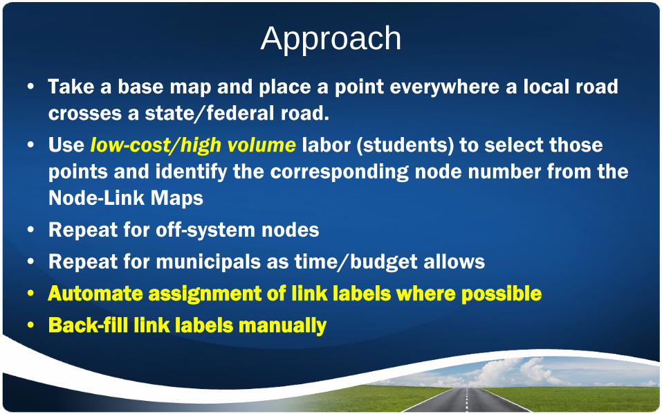
Approach • Take a base map and place a point everywhere a local road
crosses a state/federal road. • Use low-cost/high volume labor (students) to select those
points and identify the corresponding node number from the Node-Link Maps
• Repeat for off-system nodes • Repeat for municipals as time/budget allows • Automate assignment of link labels where possible • Back-fill link labels manually

Alabama Nodes • 532,000 nodes; a node for
every road name pair at an intersection and a node at the end of every link
• 330,000 unique node locations with road name pairs in a separate table
~130K On System ~220K Off System

Nodes do not exist on Link-
Node drawings
Small Intersection treated same as large
intersection


Alabama Links • 645,000 links with unique
names in Alabama (commercial source)
• Reduced to 497,000 with separate link name table
• Links are split in places where no nodes exist on the PDF drawings because the commercial data has a higher resolution than the DOT PDFs
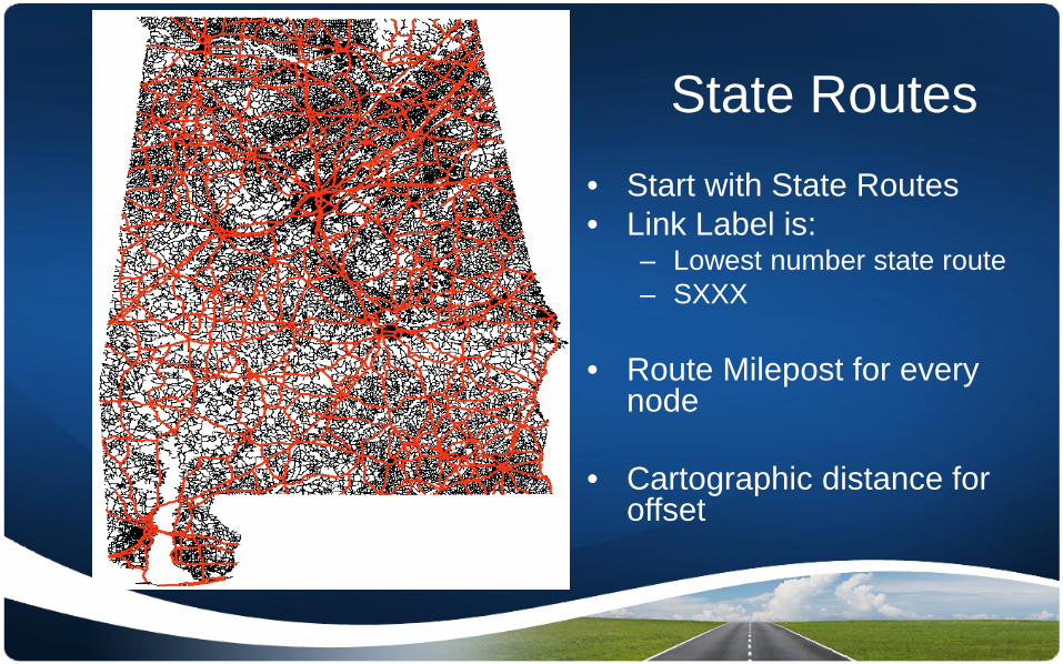
State Routes • Start with State Routes • Link Label is:
– Lowest number state route – SXXX
• Route Milepost for every
node
• Cartographic distance for offset

15th Street, Veterans Memorial Pkwy, AL215, etc.
• Every Link Label Pair is represented • Officer uses “local” label • Officer required to use proper link code

Node location table on left, street name pair table on right

State Routes • A column named “Route” was created
to show the links along state routes based on map label name, node labels, and DOT route-milepost GIS maps
• In situations where two state routes were on the same link, the PDF drawing are used to verify which state route to use
• Currently state route link data is being populated county by county.

Local Roads • A tool developed to help populate Link ID data on all local
roads in Alabama.
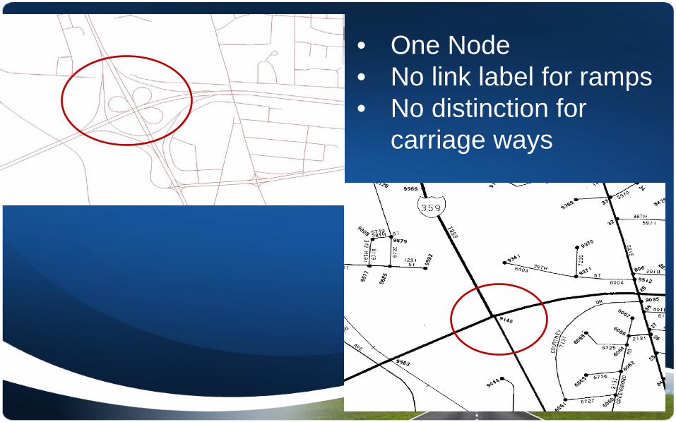
• One Node • No link label for ramps • No distinction for
carriage ways


Issues & lessons Learned • Line work used not “Authoritative
Source” • DOT working on source • Overlapping labels • Map line work/data differs from DOT
PDF data: – Map data interstate ramps as well as
interchanges whereas the PDF data does not
– Map line work shows divided highways whereas PDF shows one line in places where 2 roadways exist

Status • Nodes – 98.9% of State routes completed – 90.1% of rural/urban routes completed – QA shows >90% accuracy
• Links – 5 Months – Nodes “cleaned” for links. – Link Label data table in place – Unique statewide node identifier – Unique statewide link identifier – Alpha release to 10 State Troopers

Commercial Vehicle Crashes 2007-2008 •MP highways

• CMV June 2009-June 2011

Benefits • State of Alabama uses the CARE Software System for Crash Data analysis and
warehousing – Able to access 15+ years of historical crashes – Able to map these historical crashes – Experiences says 3-4 years best for AL
• Improved/Different Hotspot analysis – Routes through municipals – Temperature map grids
• DOT working toward LRS • Improved Data Entry
– Reduce the burden on the officer – Get the correct data to begin with
• Improved Selective Enforcement

2011 Alabama Crash Data
~48% to ~85%
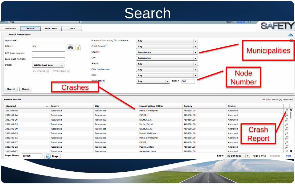
Search
Node Number
Municipalities
Crashes
Crash Report
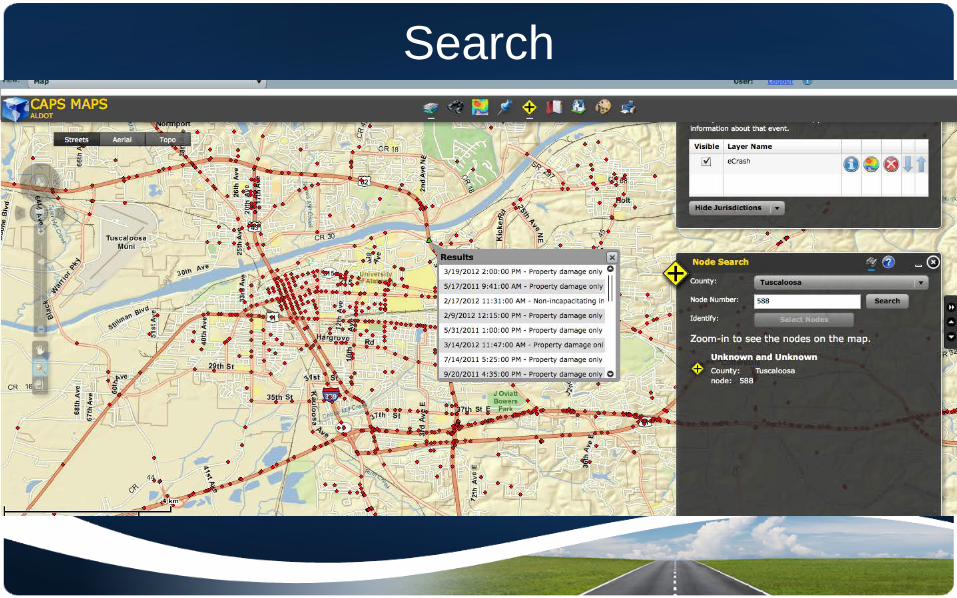
Search

Rural

Access to Crash Reports
• Privileged • Complete form • Diagram • Narrative

Hotspots • Intersections properly
oriented on Hotspot strip maps
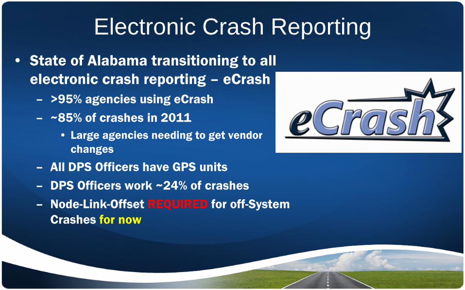
Electronic Crash Reporting • State of Alabama transitioning to all
electronic crash reporting – eCrash – >95% agencies using eCrash – ~85% of crashes in 2011
• Large agencies needing to get vendor changes
– All DPS Officers have GPS units – DPS Officers work ~24% of crashes – Node-Link-Offset REQUIRED for off-System
Crashes for now

In Car Application – MapClick
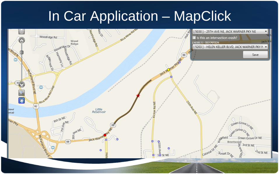
In Car Application – MapClick

Examples - GPS Link Offset
Nodes

University of Alabama
Randy K. Smith [email protected]
University of Alabama, Center for Advanced Public Safety
Mapping Crashes in the State of Alabama: An Effort Integrating Route Mile-Post and Node-
Link-Offset Methodologies

Current and Future Work • Goal
– Given 1 suggest the others
– GPS – Point and Click – 3 way
verification
• Authoritative Source
• Links!!

State of Alabama • ~327K Nodes
– ~119K Off System – ~208K On System
• 3 students (not the same for the duration)
– Part time 10-20 hrs/week – ~9 months – Trailed off – Come and go

Alabama Nodes
• 532,000 nodes; a node
for every road name pair at an intersection and a node at the end of every link
• 330,000 unique node locations with road name pairs in a separate table
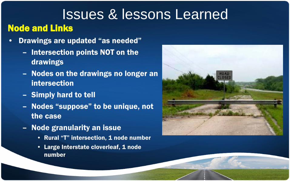
Issues & lessons Learned Node and Links • Drawings are updated “as needed”
– Intersection points NOT on the drawings
– Nodes on the drawings no longer an intersection
– Simply hard to tell – Nodes “suppose” to be unique, not
the case – Node granularity an issue
• Rural “T” intersection, 1 node number • Large Interstate cloverleaf, 1 node
number
Recommended