SYMPOSIUM
The Detroit Geographical Expedition and Institute Then and Now…:
Commentaries on Field Notes No.4: The Trumbull Community
Looking Back to Detroit for a (Counter-Mapping) Path Forward
Jim Thatcher
Urban Studies Program
University of Washington Tacoma
Founded in 1968 by Bill Bunge and Gwendolyn Warren, the history and lasting influence
of the Detroit Geographical Expedition and Institute can be told in many ways. For
Bunge, they were a site at which to continue his “geographical expedition” as research
method and at which to begin a pedagogical experiment in which “[l]ocal people are to
be incorporated as students and as professors” (Bunge 1969, quoted in Heynen and
Barnes 2011:v). They were expeditions turned inwards upon our own urban landscapes,
attempts to “subvert the exploration practices of the 19th century” (Merrifield 1995:54)
and, in so doing, to move explicitly towards a more socially just city. For his harshest
critics, this subversion failed, producing little more than yet another colonial experiment
by which geographers attempted to solve the world’s ills, this time with maps! (see Figure
1 below).
Charting the full successes, failures, and contested results of the DGEIs is
certainly beyond the scope of this review and likely impossible given that the very
number of expeditions (as well as their aims and even locations) remains debatable. For
1
example, Ron Horvath (1971) writes a eulogy for the DGEI in Antipode, only for Robert
Colenutt (1971) to respond that the work remains ongoing in the fourth DGEI, the subject
of this forum; William Bunge decries the failures of the Vancouver Expedition in the
pages of the Union of Socialist Geographers’ Newsletter, chastising them for failing to
heed the warnings of his own efforts in Toronto, only for expedition members to defend
themselves in the next issue (Bunge 1976). All of this is compounded by the fact that
many writings on the expeditions and their methodologies were simply never published
or remain not widely available (Bunge’s promised methodological text, “The Socialist
Reconstruction of Geography”, not the least among them).
Similarly, the influence of the DGEIs as research and pedagogical method
emerges and disappears in disparate ways in the years since their heyday. Mott and
Roberts (2014) note its somewhat superficial cooptation by so-called “Urban Explorers”,
while Pawson and Teather (2002) examine the benefits of using a form of Geographical
Expedition as a means of incorporating fieldwork into undergraduate education (as do
Boehm and Kracht [2007] for elementary students). Lane (2016) suggests expeditionary
method is about “placing oneself in a situation where that situation can speak back”,
which, in turn, produces a slower, deeper form of science. With these contested histories
and diverse influences in mind, I turn to the fourth DGEI and the documentation it has
produced, the Society for Human Exploration’s (1972) Field Notes No.4: The Trumbull
Community, in a way which focuses on what might be considered “most radical” about
the DGEI: “who was making the maps and the urgency felt by those mapmakers”
(D’Ignazio 2013). In other words, as someone who has called for the “revisiting” of
Critical GIS (Thatcher et al. 2016a), I wish to revisit the fourth DGEI in terms of what it
can tell us about mapping and counter-mapping today.
2
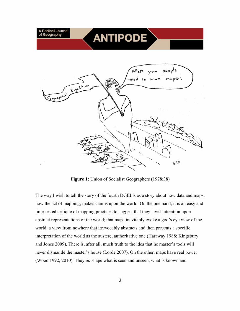
Figure 1: Union of Socialist Geographers (1978:38)
The way I wish to tell the story of the fourth DGEI is as a story about how data and maps,
how the act of mapping, makes claims upon the world. On the one hand, it is an easy and
time-tested critique of mapping practices to suggest that they lavish attention upon
abstract representations of the world; that maps inevitably evoke a god’s eye view of the
world, a view from nowhere that irrevocably abstracts and then presents a specific
interpretation of the world as the austere, authoritative one (Haraway 1988; Kingsbury
and Jones 2009). There is, after all, much truth to the idea that he master’s tools will
never dismantle the master’s house (Lorde 2007). On the other, maps have real power
(Wood 1992, 2010). They do shape what is seen and unseen, what is known and
3
unknown in both what they choose to represent and how they represent it. Maps are tools
for the production of knowledge and, as such, they are always-already deeply political.
The DGEIs were built upon this latter understanding and it is through that
commitment that I find the fourth DGEI (and the DGEIs in general) still profoundly
relevant for radical geography: first, in how the fourth DGEI speaks to current
understandings, practices, and critiques of participatory mapping and the participatory
use of geographic information systems (PGIS); and, second, in how the techniques and
methodologies of the DGEI itself demonstrate a relative lack in our own disciplinary
history. As to the first point, the fourth DGEI embraced a doubly radical idea that not
only could the lived, daily experiences of a community be made legible through mapping
and visualizations, but that both the subject and creators of said representations must
include members of the community in question. The members of the fourth DGEI did not
enter Trumbull with “any preconceived notions about the research to be undertaken, and
was thus able to respond to the daily struggles of the community and was thus able to
respond to the daily struggles of the community” (Society for Human Exploration
1972:1).
The knowledge produced through mapping, though it took the form of official-
looking tables, charts, and maps, was of the topics most directly of interest to the
community in question. While perhaps impossible within the current context of results-
oriented research funding in which expectations must always come before full
investigation, the emergent praxis of the fourth DGEI addresses some of the specters
raised by purportedly participatory mapping exercises such as the Bowman Expeditions1
and other projects where the relations between the knowledges mapped, those mapping,
and external interests, such as the military-state nexus, are obscured (Bryan and Wood
2015). While impossible to resolve the full set of tensions and power relations created by
1 See http://americangeo.org/bowman-expeditions/
4
and through mapping projects, the approach of the DGEIs is one means of moving
towards a more reflexive politics of mapping (see, among others, Dunn 2007; Finn 2014;
Schuurman and Pratt 2002). It is a praxis which provides one answer to Wainwright’s
(2013:71) question of how we represent “space and place after the postcolonial critique”:
through a radical, participatory, grounded empiricism, and the topics and knowledges it
produces. For the fourth DGEI, this approach resulted in research into “problems of
housing, police protection, and health services” as well as their intervention into “a
locational conflict over the use of local recreation space” (Colenutt 1971:85). Beyond the
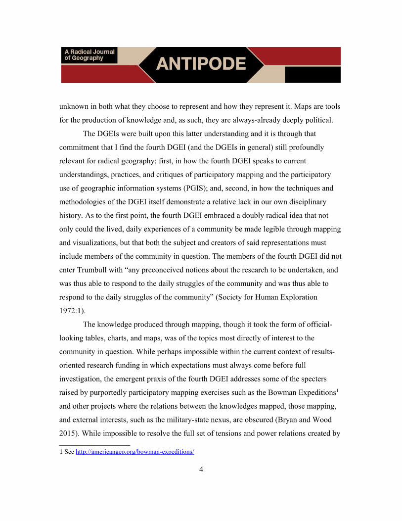
DGEIs’ epistemology and praxis, it is the quality and innovative nature of the maps and
visualizations produced through these that I would like to call attention to in closing.
Figure 2: Society for Human Exploration (1972:25)
5
One of my favorite visualizations of 2015 was a set of maps linking vacant properties in
Louisville to the owner of said properties (Shelton 2015). While I am not so great a
cartographer to claim the ability to judge the maps in and of themselves, what I found
most fascinating in them was the linking of seemingly disparate spaces together through
their economic ties. While still visualized within Newtonian space, Shelton’s maps
suggest possibilities to rethinking Geographic Information Systems into, what Bergmann
and Lally (2016) have suggested we call, Geographic Imaginary Systems: as means of
bringing the “situated, dynamic, processual, relational, and contingent” understandings of
space into our cartographic practices.
Table II, which lists the addresses of abandoned buildings and the addresses of
said buildings’ owners, and Figure 8 (reproduced above as Figure 2; Society for Human
Exploration 1972:20, 25) remind me of these same practices. That the DGEI would
engage in these types of visualization is unsurprising given their roots in the work of Bill
Bunge, a pioneer of this type of spatial thinking.2 It is also unsurprising that much of this
work fell by the wayside in the years after the DGEI. There are tactical and social reasons
behind the valorization of specific types of spatial conceptualizations over others
(Thatcher et al. 2016b), and Bunge’s own unceremonious exit from the academy certainly
did not help matters (for more on the life and influence of the late Bunge, see Bergmann
and Morrill forthcoming).
This forum is meant to resurrect the seemingly lost field notes of the fourth DGEI.
But, as we bring these works back, as Bunge’s own work is rehabilitated into geography
(Barnes and Heynen 2011), we must not reproduce an artificial distinction between
qualitative and quantitative. We cannot take the profound, radical, qualitative, empirical
practices of the DGEI and ignore the equally significant quantitative visualizations. The
2 See his work on isochrone maps of Seattle; Figures 2.13, 2.14, 2.17 and 2.18 in Theoretical Geography
(Bunge 1962).
6
ways of knowing produced in and through the creation and interpretation of spatial
information can be just as critical, just as radical, as those produced through more
traditionally qualitative means. The Detroit Geographical Expedition and Institutes
embodied this spirit; they understood the power of said visualizations and their ability to
make legible claims within systems of unequal power relations. The success of the fourth
DGEI in resisting the transformation of Matthaei Field into a parking lot attests to this.
The systemic inequities that made the DGEIs so powerful as praxis have not disappeared
and so, as we revisit the fourth Detroit Geographical Expedition and Institute, we must
keep firmly in front of us the power and creativity contained within their mapping
practices and products.
References
Barnes T and Heynen N (2011) Classics in human geography revisited: William W.
Bunge (1971) Fitzgerald: Geography of a Revolution. Progress in Human
Geography 35(5):712-720
Bergmann L and Lally N (2016) “Introducing Geographical Imagination Systems.” Paper
presented to the North American Cartographic Information Society Annual
Meeting, Colorado Springs, October
https://nacis2016.sched.org/event/7LnQ/rethinking-the-map (last accessed 13
January 2017)
Bergmann B and Morrill R (forthcoming) William Bunge: Radical geographer (1928-
2013)
Bryan J and Wood D (2015) Weaponizing Maps: Indigenous Peoples and
Counterinsurgency in the Americas. New York: Guilford Press
Bunge W (1962) Theoretical Geography. Lund: Gleerup
7
Bunge W (1969) The first years of the Detroit Geographical Expedition: A personal
report. In R J Horvath and E J Vander Velde (eds) Field Notes No.1: The Detroit
Geographical Expedition. Detroit: Detroit Geographical Expedition and Institute
https://radicalantipode.files.wordpress.com/2017/01/dgei_fieldnotes-i.pdf (last
accessed 1 January 2017)
Bunge W (1976) Geographical expeditions: An analyses. USG Newsletter 1(4/5):40-42
Boehm R G and Kracht J B (1974) Geographical Expeditions: Field work for the
elementary grades. Journal of Geography 73(6):7-12
Colenutt R (1971) Postscript on the Detroit Geographical Expedition. Antipode 3(1):85
D’Ignazio C (2013) The Detroit Geographic Expedition and Institute: A case study in
civic mapping. MIT Center for Civic Media Blog 7 August
https://civic.mit.edu/blog/kanarinka/the-detroit-geographic-expedition-and-
institute-a-case-study-in-civic-mapping (last accessed 13 January 2017)
Dunn C E (2007) Participatory GIS–a people’s GIS? Progress in Human Geography
31(5):616-637
Finn J C (2014) Introduction: Book review symposium on Joel Wainwirght’s Geopiracy:
Oaxaca, Militant Empiricism, and Geographical Thought. Human Geography
7(3):61-65
Haraway D (1988) Situated knowledges: The science question in feminism and the
privilege of partial perspective. Feminist Studies 14(3):575-599
Heynen N and Barnes B (2011) Foreword. In W Bunge Fitzgerald: Geography of a
Revolution (new edn) (ppvii-xiii). Athens: University of Georgia Press
Horvath R J (1971) The “Detroit Geographical Expedition and Institute” experience.
Antipode 3(1):73-85
Kingsbury P and Jones III J P (2009) Walter Benjamin’s Dionysian adventures on
Google Earth. Geoforum 40(4):502-513
8
Lane S N (2016) Slow science, the geographical expedition, and critical physical
geography. The Canadian Geographer / Le Géographe canadien DOI:
10.1111/cag.12329
Lorde A (2007 [1984]) The master’s tools will never dismantle the master’s house. In id.
Sister Outsider: Essays and Speeches (pp110-113). Berkeley: Crossing Press
Merrifield A (1995) Situated knowledge through exploration: Reflections on Bunge’s
geographical expeditions. Antipode 27(1):49-70
Mott C and Roberts S M (2014) Not everyone has (the) balls: Urban exploration and the
peristence of masculinist geography. Antipode 46(1):229-245
Pawson E and Teather E K (2002) “Geographical Expeditions”: Assessing the benefits of
a student-driven fieldwork method. Journal of Geography in Higher Education
26(3):275-289
Schuurman N and Pratt G (2002) Care of the subject: Feminism and critiques of GIS.
Gender, Place, and Culture 9(3):291-299
Shelton T (2015( No vacant property is an island: Geographies of vacancy in Louisville
and why we should care. Broken Sidewalk 2 June
http://brokensidewalk.com/2015/no-vacant-property-is-an-island/ (last accessed
13 January 2017)
Society for Human Exploration (1972) Field Notes No.4: The Trumbull Community.
Detroit: Society for Human Exploration
https://radicalantipode.files.wordpress.com/2017/01/dgei_fieldnotes-iv.pdf (last
accessed 13 January 2017)
Thatcher J, Bergmann L, O’Sullivan D, Ricker B, Rose-Redwood R, Barnes T,
Barnesmoore L, Imaoka L, Burns R, Cinnamon J, Dalton C, Davis C, Dunn S,
Harvey F, Jung J, Kersten E, Knigge L, Lally N, Lin W, Mahmoudi D, Martin M,
Payne W, Sheikh A, Shelton T, Sheppard E, Strother C, Tarr A and Wilson M
9
(2016a) Revisiting critical GIS: Reflections from Friday Harbor. Environment
and Planning A 48(5):815-824
Thatcher J, Bergmann L and O’Sullivan D (2016b) “Seeking Common Ground (Again).”
Paper presented to the 9th International Conference on Geographical Information
Science, Montreal, September
Union of Socialist Geographers (1978) USG Newsletter 3(3)
https://radicalantipode.files.wordpress.com/2017/01/usg-newsletter-33_1978.pdf
(last accessed 13 January 2017)
Wainwright J (2013) Geopiracy: Oaxaca, Militant Empiricism, and Geographical
Thought. New York: Palgrave Macmillan
Wood D (1992) The Power of Maps. New York: Guilford
Wood D (2010) Rethinking the Power of Maps. New York: Guilford
10
Recommended