!"#$"#%&'()*%+,-&,.-,/0#
12/$*

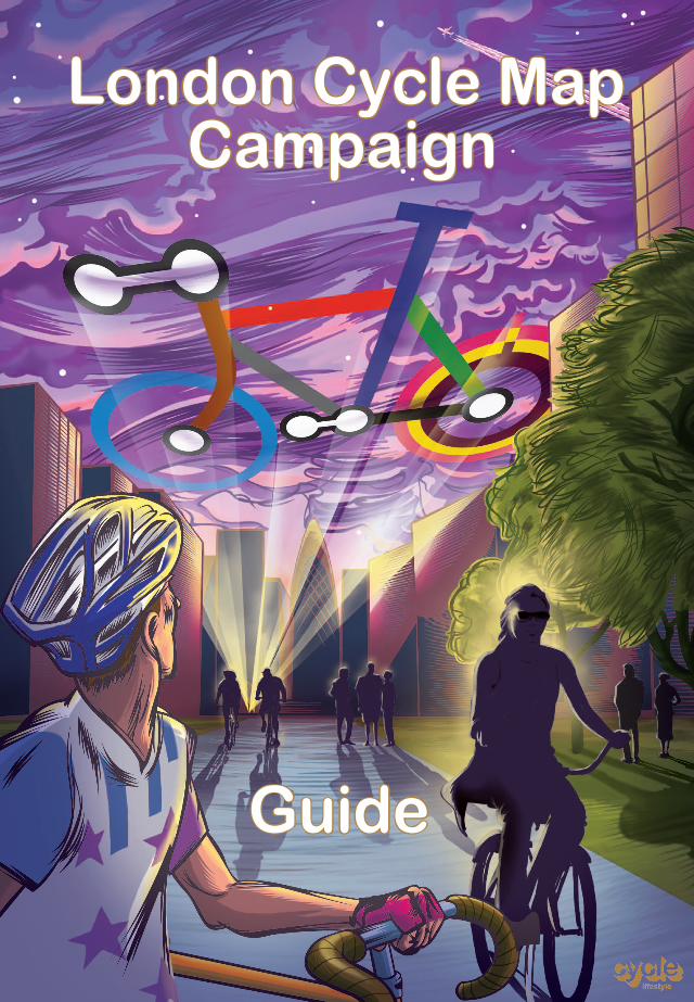
e believe there should be a single 'London Cycle Map' that's
of signed cycle routes throughout Greater London: the cycling
equivalent of the London Underground Map.
!
!"#$%&'(%)*+Why I am backing the London Cycle Map Campaign
By Brian Deegan, Development Manager for the London Cycle Network
It is true to say that Simon Parker!s colour-coded Tube-style mapping system has met with mixed reviews from the current cycling establishment. Some believe the system to be too complex, too much of a departure, or not aligned with their own policies. Some prefer signing using London Cycle Network route numbers, or bikeability ratings, while others concentrate on greenways and leisure routes. The trouble is, with 33 different local authorities, TfL, The Royal Parks and British Waterways adopting different policies towards cycle signage, the result is a somewhat confusing mess. The current state of affairs – with several cycling mapping systems in operation – is simply not acceptable and in my view discourages and impedes cycling growth. I think we all need to put our heads together and agree on one system then implement it consistently across London.
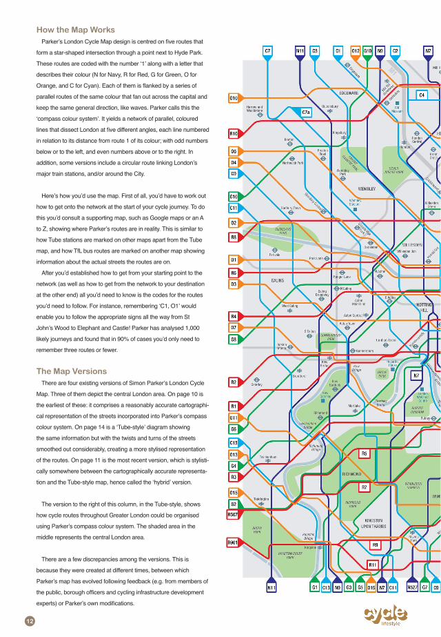
This system would have to be expansive yet inclusive of work on both a macro and micro level, be elegant yet
this system, and in my opinion the best idea to have come along is the Tube-style approach based on the compass colour system devised by Simon Parker. This has the highest potential to attract new cyclists, as well as offering schematic simplicity and engaging design. It will take a lot of work and commitment to establish this system, but I
I do not in any way want to disparage any effort to promote cycling through mapping systems developed so far. In fact, I applaud them and am personally responsible for some of them. My reason for providing this testimonial is that we are now in a position where cycling can truly become a mainstream transport option in London, and I believe we need a sophisticated mapping system to make the best planning tools and information available to cyclists, enabling them to better plan their journeys in a convenient way.
ours. So we need to invent our own. Simon Parker!s system is a great invention and the compass colour methodol-ogy is ingenious. I wish to give his work and Cycle Lifestyle!s London Cycle Map Campaign my full backing and support.
The views stated above are very much my own and not those of the organisations I represent. I write this testimo-nial to applaud the effort of the amateur, which is in keeping with the true spirit of cycling.
,
4-5. Campaign Introduction
6-7. London Needs a Cycle Network
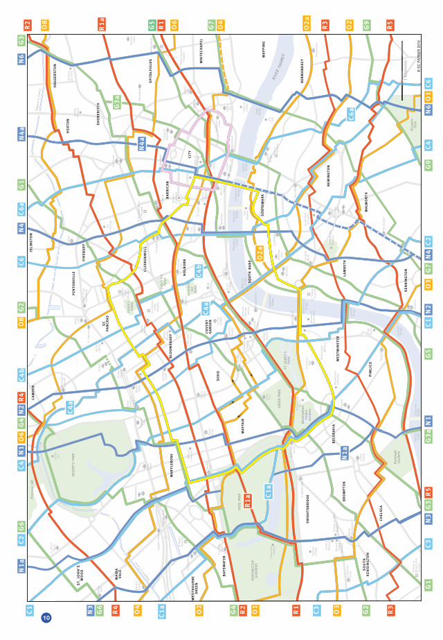
10. LCM (cartographically accurate)
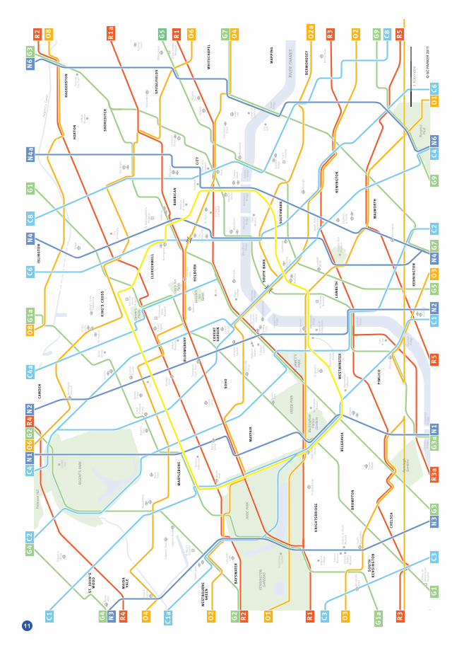
11. LCM (hybrid)
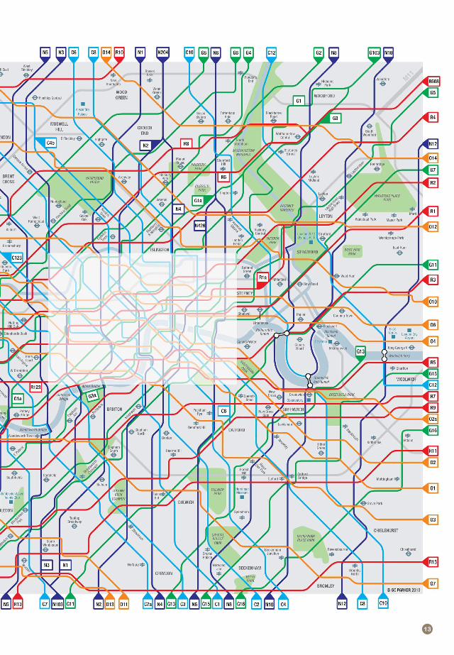
12-13. LCM (Greater London)
14. LCM (Tube-style)
15-22. Q&A
23. Going Forward
24. About Cycle Lifestyle
Tube-style London Cycle Map (including Greater London version) drawn by Jonathan Haste (www.kolbillustration.com)
All other London Cycle Maps drawn by Martin Lubikowski (www.ml-design.co.uk)
Special thanks to Stuart France (www.stuffanimated.com)
www.oldspeak.co.uk
ycle Lifestyle!s innovative campaign and petition promises to change the capital forever, by giving more people
in safety. The big idea is to create a single "London Cycle Map! that!s clear and easy to use and cor-
throughout Greater London: the cycling equivalent of the London Underground Map.
!"##$%&'()(*$%&'+%'#,-'./0'$%'1+%2+%
!"#$"#%&'()*%+,-&,.-,/0#
there!s no consistency in their signage, and you need
123*%4/0%/$*,%/5%6"%(7*,6*%,%5/#0)*%8!"#$"#%&'()*%+,-8%63,685%()*,7%,#$%*,5'%6"%95*:
;
bunches of different maps to cover Greater London.
Something similar is needed today for the capital!s cycle routes. Instead of remembering hundreds of "turn rights! and "turn lefts! you could just remember
Map – into a greener, cleaner, quieter and friendlier city.
There's a petition at !!!"#$%&%&'(")'"*+,-'(.'(/
)0)-$/12#/)21#2&3(4and more information at !!!")0)-$-&5$6%0-$")'"*+
789$:$;$:40'*4!$:$4&(4<'(.'(=40'*>.4?$4!&%9&(41&(*%$64'5424)0)-$4($%!':+4%92%4)'*-.4-$2.40'*4!9$:$;$:40'*4!2(%$.4%'43'@
A
!"#$%&'()*+',&+-").")+!/0%&+1&'2"34+$3"5&0'
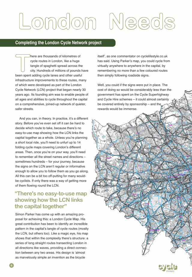
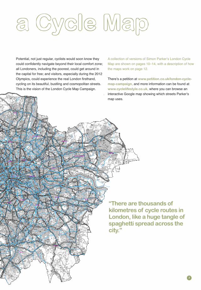
!"#$"#%%&''$(here are thousands of kilometres of cycle routes in London, like a huge tangle of spaghetti spread across the city. Hundreds of millions of pounds have
been spent adding cycle lanes and other useful infrastructure improvements to these routes, many of which were developed as part of the London Cycle Network (LCN) project that began nearly 30 years ago. Its founding aim was to enable people of all ages and abilities to cycle throughout the capital on a comprehensive, joined-up network of quieter, safer streets.
And you can, in theory. In practice, it!s a different story. Before you!ve even set off it can be hard to decide which route to take, because there!s no easy-to-use map showing how the LCN links the capital together as a whole. Unless you!re planning a short local ride, you!ll need to unfurl up to 14 folding cycle maps covering London!s different areas. Then, once you!re on your way, you!ll need to remember all the street names and directions – sometimes hundreds – for your journey, because the signs on the LCN aren!t regular or informative enough to allow you to follow them as you go along. All this can be a bit too off-putting for many would-be cyclists. If only there was a way of getting more
Simon Parker has come up with an amazing pro-posal for achieving this: a London Cycle Map. His great contribution has been to identify an incredible pattern in the capital!s tangle of cycle routes (mostly the LCN, but others too). Like a magic eye, his map shows that within the complexity there!s structure: a series of long straight routes transecting London in all directions like waves, providing a direct connec-tion between any two areas. His design is "almost as marvelously simple an invention as the bicycle
itself!, as one commentator on cyclelifestyle.co.uk has said. Using Parker!s map, you could cycle from virtually anywhere to anywhere in the capital, by remembering no more than a few coloured routes then simply following roadside signs.
Well, you could if the signs were put in place. The cost of doing so would be considerably less than the government has spent on the Cycle Superhighway and Cycle Hire schemes – it could almost certainly be covered entirely by sponsorship – and the rewards would be immense.
)*+','-(%#"%'.(/01"02('%3.4%(+"56#7%+"5%1+'%!8&%96#:(%1+'%;.461.9%1"7'1+',<
=
!"#$%&'"(!)
*+,'-'"!-'".,/01!231"/4 "56&/7'.-'1"/4"%$%&'"-/0.'1"62"8/23/29"&65'"!",0:'".!2:&'"/4 "1)!:,'..6"1)-'!3"!%-/11".,'"%6.$;<
Potential, not just regular, cyclists would soon know they
all Londoners, including the poorest, could get around in
;
=
>>>;)'.6.6/2;%/;05?&/23/2@%$%&'@
7!)@%!7)!6:29" >>>;%$%&'&64'1.$&';%/;059"
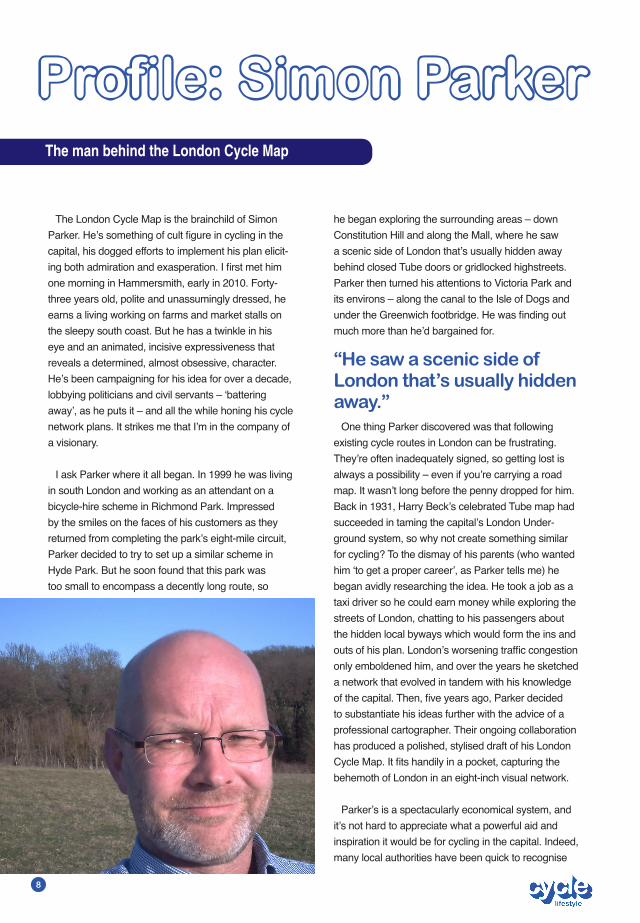
The London Cycle Map is the brainchild of Simon
capital, his dogged efforts to implement his plan elicit-
one morning in Hammersmith, early in 2010. Forty-three years old, polite and unassumingly dressed, he earns a living working on farms and market stalls on the sleepy south coast. But he has a twinkle in his eye and an animated, incisive expressiveness that reveals a determined, almost obsessive, character. He!s been campaigning for his idea for over a decade, lobbying politicians and civil servants – "battering away!, as he puts it – and all the while honing his cycle network plans. It strikes me that I!m in the company of a visionary.
I ask Parker where it all began. In 1999 he was living in south London and working as an attendant on a bicycle-hire scheme in Richmond Park. Impressed by the smiles on the faces of his customers as they returned from completing the park!s eight-mile circuit, Parker decided to try to set up a similar scheme in Hyde Park. But he soon found that this park was too small to encompass a decently long route, so
!"#$%&'$(#")'*$+"#$,-'*-'$./01#$2&3
!"#$%&'()*%+#,)!-".'")
he began exploring the surrounding areas – down Constitution Hill and along the Mall, where he saw a scenic side of London that!s usually hidden away behind closed Tube doors or gridlocked highstreets. Parker then turned his attentions to Victoria Park and its environs – along the canal to the Isle of Dogs and
much more than he!d bargained for.
One thing Parker discovered was that following existing cycle routes in London can be frustrating. They!re often inadequately signed, so getting lost is always a possibility – even if you!re carrying a road map. It wasn!t long before the penny dropped for him. Back in 1931, Harry Beck!s celebrated Tube map had succeeded in taming the capital!s London Under-ground system, so why not create something similar for cycling? To the dismay of his parents (who wanted him "to get a proper career!, as Parker tells me) he began avidly researching the idea. He took a job as a taxi driver so he could earn money while exploring the streets of London, chatting to his passengers about the hidden local byways which would form the ins and
only emboldened him, and over the years he sketched a network that evolved in tandem with his knowledge
to substantiate his ideas further with the advice of a professional cartographer. Their ongoing collaboration has produced a polished, stylised draft of his London
behemoth of London in an eight-inch visual network.
Parker!s is a spectacularly economical system, and it!s not hard to appreciate what a powerful aid and inspiration it would be for cycling in the capital. Indeed, many local authorities have been quick to recognise
/0')1-2)-)13',%3)1%4')#$ )5#,4#,)67-681)919-&&:)7%44',)-2-:;<
=
the potential of his plan and have offered their support – not least because each of them would only need to spend approximately £50,000 to implement it. To put this in perspective, it!s equivalent to the cost of employing
What makes the implementation so affordable is that it!s based on the concept of "Minimum Functioning!, as
instance planners do only the minimum necessary to
Parker puts it. In practical terms this means signing the
start using the routes, further amendments can be made, such as dedicated cycle lanes and other special features. It!s a logical progression, since the public would only be willing to meet the costs – in terms of resources and inconvenience – for elaborate provisions once they
position to appreciate the potential for improvements.
So is the network being developed right now? Sadly not. A large-scale project like this needs the backing of Transport for London, and this is where Parker!s plans have been thwarted repeatedly. One senior developer there called the plans "complex and confusing!; but I wonder if that!s a better verdict on the bureaucratic process that delivered it than the exquisitely simple diagrams I!m looking at. Parker himself remains resolutely conciliatory – even if I sense emotion in his
and commerce, if they were not made of India rubber, would never manage to bounce over the obstacles which legislators are continually putting in their way; and, if one were to judge these men wholly by the effects of their actions, and not partly by their intentions, they would deserve to be classed and punished with those mischievous persons who put obstructions on the railroads”.
I!m intrigued by the citation, and I suppose Parker him-self must be made of rubber. I begin to wonder where he gets his inspiration from in persevering with such an
I can!t see the connection, but Parker elaborates. As a
approach; the very same outlook that!s needed to
whatever the political or cultural obstacles. I see the
own down-to-earth, practical kind of idealism. Later I was struck by another parallel, between the
and Parker!s commitment to Minimum Functioning
organs that must start out rudimentary before evolv-
suspect that a people-based approach may be needed if his vision is to become a reality. There!s an online petition you can sign (www.petition.co.uk/london-cycle-map-campaign) if you support his vision of a capital city where you can easily get from anywhere to anywhere by bicycle. But, more than this, Parker wants feedback. He explains to me that his map has been evolving for years, with clunkier routes giving way to more streamlined descendents. He wants people to offer their suggestions, to help shape his plan further, to yield the diamond that London!s cyclists deserve.
I!ve enjoyed our meeting tremendously, but Parker has made one suggestion that!s inspired me above all. He insists that each generation should strive
exhortation that "when we build, let us think we build forever!. With the 2012 Olympics just a year away I can hardly think of a better gift to future generations of Londoners than the fully accessible cycle network detailed in Parker!s amazing blueprints.
!"#$%&#'%()*+#,'-&.#/0#%#12,,2(#3-0,#,/#04,4(2#32&2(%,-/&56
7
Reg
ent’s
Can
al
© S
C P
AR
KER
201
0
Re
ge
nt ’
s C
an
a l
!"
© S
C P
AR
KER
201
1
Re
ge
nt ’
s C
an
a l
!!
!"
#$%&'()&*+,&-$./0
1()&*+,&2).03$40
-
-
-
!"
!"
If you ask a non-cyclist why they don!t cycle in London, the
chances are they!ll say “it!s too dangerous”, or “it!s too hard to
navigate”. The two assumptions are often linked: people are
worried that getting lost on a bike will make them more vulnerable.
Wouldn!t it be great, then, if London had a cycle network that was
as safe and easy to get around as the London Underground? If
London had cycle routes similar to the Victoria Line, the Circle Line,
the Bakerloo Line, and so on? If London had a cycle map that was
as user-friendly, clear and stylish as its famous Tube-map?
Wouldn!t it be great, that is, if you could cycle throughout the
capital just by consulting a London Cycle Map, remembering a few
colour-coded routes, and then following signs on a safe, continuous
and reliable network just as you do on the Tube?
Most people!s reaction to this is: “Great idea! It would make
cycling in London so much easier!” (Except those who think it
means cycling through tunnels: it doesn!t). But truly great ideas
must stand up to scrutiny. So, in this article, we respond to some of
the most common questions and criticisms relating to the idea of a
London Cycle Map.
!"#$%&$%'$())*)*+
At the moment, London has a variety of different cycle route
systems, including many quiet routes, often with dedicated
provisioning for cyclists (e.g. cycle lanes and other road markings).
Most prominent are the London Cycle Network and its successor
the London Cycle Network Plus. Then there are lots of different lo-
cal authority routes, a range of London Cycling Campaign advisory
various routes managed by the transport charity Sustrans, namely,
the National Cycle Network routes, Greenways routes, and Safe
Routes to School. All of these various route systems are supported
by different signs and maps: there is no single map, or system of
the capital. So, for many cycle journeys you need multiple maps
and a knowledge of multiple systems of signage.
You also need to know the names of the streets the routes are
remembering lots of "turn rights! and "turn lefts! to get to your
destination – either that, or consulting multiple maps throughout
your journey. This is especially true for longer cycle journeys in the
capital.
!"#$%&'()$*'+,)'&-$""'.(/0+
,-.$ In a nutshell, London has a tangle of cycle routes, with different
that detailed planning and memory is necessary for all but the most
local cycle journeys. The situation is similar to catching a Tube train in
the early twentieth century. In 1931, Harry Beck!s famous Tube map
succeeded in taming a complex system of tracks – making it far easier
to navigate. He was an uncommissioned hobbyist at the time, but now
Beck!s design is synonymous with catching the Tube in London: you
just take one look at the map, identify which lines to travel on, which
direction to travel in, where to change, then away you go. With a
minimum of planning and memory you can follow signs that take you
from virtually anywhere to anywhere in the capital.
Something similar is needed today for cycling in the capital: a single
London Cycle Map that you can take one look at, identify which routes
to travel on, which direction to travel in, where to change, then away
you go. With a minimum of planning and memory you could follow
signs which would enable you to cycle from virtually anywhere to
anywhere in London.
!"/$%&$%'$0/1+
Pretty much anyone who needs to get around in the capital –
whether commuters beating the rat race, students hopping from
lectures to cafes to parties, shoppers hitting the highstreets, football
fans cruising to the game, families exploring on a fun day out, friends
meeting for a bike ride, tourists using bicycles to visit parks and
The most exciting thing about a London Cycle Map is that it would
the two main perceived barriers to cycling – navigation and safety – it
would provide encouragement to people who otherwise might not
Perhaps, indeed, one of the reasons why there isn!t already a
would-be cyclists! There are, of course, lobby groups for cyclists in
London, but that!s not the same thing. If you!re already a regular cy-
clist in the capital then it might not be obvious that regular Londoners
bike. It might not be obvious, in other words, that a London Cycle Map
is so sorely needed. This is an irony, because the best way to improve
conditions for current cyclists – for the lobby groups to achieve their
aims – is to get more people cycling, by removing the navigational and
One of the oddest objections I!ve heard to the idea of a London
Cycle Map is that some very experienced cyclists might not necessar-
ily want to cycle on networked routes – they may prefer the freedom of
choosing where to cycle, perhaps choosing their own favoured routes
from memory. Well, no-body!s telling anybody where to cycle! Even if
23
the capital had a proper London Cycle Map, cyclists could still cycle
on whichever streets they wanted to (indeed, they!d have to – to get
on and off the network). And they could still use the networked routes
as normal streets – simply by not consulting the map. If some cyclists
didn!t want to exploit the enormous increases in journey-planning
could just ignore the routes. Or ignore the signs, just like you ignore
all the rubbish bins, pigeons and parking meters you see when
you!re cycling around. It would be like visiting, say, Amsterdam or
Hamburg and riding around without taking notice of the excellent
cycle networks which make cycling in those cities so much easier for
tourists and residents alike.
!"#$%&'($#"&)*$+,$'"-,.
Brian Deegan, development manager for the London Cycle
Network, has estimated that it would cost around £1.6 million to
implement a London Cycle Map (£50,000 for each of the capital!s
-
London Cycle Map would be so affordable is that its implementation
would be based on a well-established concept known as "minimum
!"#$#"&)*$+,$/0$+%1)0%02,0*.
After designing the map itself, the most important requirement
information to already existing signs, or providing additional signs
the routes on the network should be navigable using the roadside
to the London Underground: in both cases the only information
needed for making a journey should be a simple map, together with
the corresponding signage on the network.
Actually, this could be achieved for cycling even more cheaply
than Brian Deegan has estimated. In theory (although not legally, so
I am not endorsing this), a committed group of amateurs could get a
London Cycle Map and network functioning minimally more or less
the routes with the appropriate insignia (rings of colour with numbers
and letters, in the case of Parker!s design) plus arrows showing
where and when to turn.
Once the London Cycle Map and network had been minimally
implemented, people would soon start cycling on the routes – prob-
for cyclists could be added. Coloured road markings could be
included, the existing signs could be upgraded with lamps to make
them more visible at night, and London Cycle Maps could be
be subsidiary local (perhaps "grey!) routes signed, leading off the
network and towards landmarks and popular destinations.
3-24,$105%06/+)+,7$6$/+8805$15+"5+,7.
"Permeability! in cycling is a technical term meaning the number of
connections that can be made on a bicycle between streets, parks,
If there are only a few holes then it takes longer for the water to
get through. Likewise, the fewer connections there are, the longer
and gyratories (where the volume and distribution of motor vehicles
makes it dangerous to be on two wheels) or physical blockages like
railways lines.
Permeability is undoubtedly important at a local level, but London
because it!s much harder to cycle from, say, one borough to another
than it is to cycle within your own borough, and this is what is prevent-
ing London from being a cycling city, as opposed to a series of cycling
permeability correlates strongly with increasing cycling. But things are
different in a metropolis like London, where people!s social, leisure
and work activities are typically spread across a relatively large area.
Until people can routinely and spontaneously cycle from one part of
the capital to another, its predominant modes of transportation will
Of course, more and more people are discovering that cycling is
worth the extra investment in preparation and navigation. But the
fact is, if you want to encourage people to make positive lifestyle and
environmental changes then you have to make it easy for them. A
London Cycle Map would make it so much easier to cycle throughout
the capital.
9(+'($5"&,0-$#"&)*$6$:"2*"2$;7')0$<61$&-0.
extend throughout as much of the capital as possible, but inevitably
many journeys in the capital involve its central areas.
Another sensible bias will be for using the routes which currently
make up the London Cycle Network and the London Cycle Network
-
though not entirely – see below – on historical/political considerations;
so for the purposes of this Q and A I!m going to refer to them both
simply as the "London Cycle Network!, or "LCN!). You will probably be
familiar with the LCN!s blue signs, with their iconic white bicycle
=>
logos, and you!ll have seen those logos painted on the capital!s
the course of decades of government-funded research, as being
well-suited to supporting cycle journeys. Most of the routes on
the LCN have been provisioned with cycle lanes and other useful
cycling facilities, to make cycling on these roads a safer and more
salient activity.
Focusing on the LCN is sensible because of its suitability for
this role because its routes are not just good for cycling on; they!re
good for connecting on; they were selected from the beginning
by the authorities because of their usefulness for transportation pur-
poses, for making logistically meaningful journeys on a bicycle from
one part of the capital to another. In comparison, some of London!s
other cycle routes are more scenic – like a steam railway that you!d
ride on for the pleasure of it, rather than to go anywhere.
The irony is, the main thing the LCN lacks (as anyone who has
ridden on it will tell you) is a decent map and system of signage
showing how its routes connect together! This is where the London
Cycle Map Campaign comes in. The current LCN is like the "raw
material! for a London Cycle Map: a set of routes that already
exists in a useful pattern of connections, but which – just like the
underground network was before 1931 – is crying out for a decent
on it. You could think of a London Cycle Map as completing the
LCN; accomplishing its original mission of providing a London-wide
network of navigable cycle routes.
Another of the reasons for using LCN routes as the basis of a
London Cycle Map is that those routes are, on the whole, quieter
and calmer for cycling on than the capital!s major roads. (Although
to be completely accurate here, one of the differences, mentioned
above, between the LCN Plus and the original LCN is that the
former prioritizes speed slightly more than the latter did. Still, on the
whole, both networks are safer and quieter than many of London!s
major roads). Some of the capital!s more hardened cyclists might
dispute the policy of using calmer roads, preferring the speed and
directness of London!s major roads. But in a way it doesn!t matter
– because they!re the people who need a London Cycle Map the
least.The ones with the greatest need are all those cyclists and
Londoners (myself included). When you take into account the fact
that avoiding major roads makes it harder to plan longer journeys,
a London Cycle Map using quieter roads becomes even more
important for getting people around on bikes in the capital.
There!s a safety issue involved too – one which suggests
that the capital!s hardened cyclists may need a London Cycle
Map more than they realise. Ted Reilly from the Department
of Transport recently compiled a map showing the locations of
the cycling fatalities and serious injuries which occurred in the
capital between 2000 and 2008. Most such accidents occurred
on major roads – unsurprisingly, since that!s where Heavy Goods
Vehicles (HGVs), the most serious threat to cyclists, are in higher
concentration.
Of course, some will argue that this means resources should
be spent on improving safety on the capital!s major roads, rather
than funneling cyclists away from them. And there!s apparently an
ideological point backing up the practical one: that people should
be able to cycle on any road they like, without fear. However, there
are two considerations which favour the London Cycle Map as the
truly progressive option.
First, on the practical side, the capital!s major roads are often
unsuitable for incorporating effective safety measures for cyclists.
Many of these roads are so narrow, and carry so many pedestrians
on their footpaths, there!s no room for cycling infrastructure. Second,
the ideological point ignores the fact that London will always need
HGVs and other forms of industrial transportation, and major roads
are their only realistic means of conveyance, since London!s quieter
say, children playing in them). It!s a case of "horses for courses!.
Cycling, and therefore a London Cycle Map, is usually better on
calmer streets.
A capital city whose major roads are mainly full of cyclists is a
nice, utopian thought. But the problem with utopias is that they!re
unrealistic. The real way to get more Londoners onto bicycles is
not to crowbar them onto major roads, like reluctant insurgents, but
to introduce them gently to cycling. This is not to say that cyclists
shouldn!t be allowed to use major roads, and be respected by drivers
when they do so. Let me be clear: cyclists should be able to cycle, in
an atmosphere of respect, on any road, however major, on which it!s
legal to do so. Nothing in the idea of a London Cycle Map jeopardises
this fact. Indeed, those hardened cyclists who do prefer major roads
succeed in getting more people out of their cars and onto bikes, so
the main roads would lose a few cars, if not vans and trucks.
!"#$%#&'($%)*+,-%./012%3(425"67"8#/-9
If you do want to cycle at high speed on busier roads, then
of course the Cycle Superhighways are great. They should be
incorporated into a London Cycle Map (as they are in Parker!s), and
marked as routes for more experienced cyclists. There could even
be a simple grading system for the whole network, so people would
:;<
=>
!"#$#%&&$'("'&($)*"#$#+(,($-+($,".-(/$0,(1
This sounds like a strange question. But consider what happens
when you use the London Underground. You need to know where
the stations are at the start and end of your journey, otherwise
-
of coloured lines.
you could consult it and spontaneously cycle to anywhere you can
popular destinations.
journey.
and the London Underground, in respect of journey planning,
On the rare occasions when you!re not sure which direction
23
!"#$%#&'($%$")%*+,-)%./0)%1,")2)3
TfL!s excellent Cycle Hire scheme launched in August 2010. You
can now hire a bicycle from hundreds of docking stations throughout
the city. Great idea, yet something!s missing. When you look at the
no information whatsoever about which streets are good for cycling
to hire a bike, but to use it to navigate throughout central London
!"+%4'$%5(1$%(1)%$")%6)&3
they don!t make it easy to navigate across longer distances in the
to the two or three you'd need when using Parker!s London Cycle
bering all those directions. This seems like a great idea at face value.
if you missed your turning or got confused, because they!d only know
what the voice in their ear was telling them. Plus you!d have to be
of cycle routes, looking out for signs telling you where to go. But the
screen in a cinema.
you in the right direction as there is on the Tube, or as there would be on
accessible cycle network would, in a stroke, lower the baseline level
travelling to work.
!"#$71%1'%8''9%#&'($%:/2'4%;#0<)071%2#=3
>?@
AB
nious solution to the problem of conveying a huge amount of route
information economically and simply. To appreciate the brilliance of
Parker's solution, it helps to consider the alternatives.
The most obvious alternative is to number all of London!s eighty
or so LCN routes individually on a single map, as the old LCN map
did. With a route-numbering system like this you'd have to remember
all the numbers of the routes you!d need to follow during your cycle
journey, and change from one to the other where appropriate.
One problem with this option is that for many cycle journeys in
a big city like London there would be quite a few route numbers
to remember. Another problem is that representing hundreds of
numbered routes on a single map looks cumbersome. An alternative
solution would be to number the places where the routes cross each
other, at locations called 'nodes' – as in the node-based system in
Flanders, Belgium. Again, though, in a big city like London you'd have
to remember lots of nodes to get from one place to the other (up
to twenty for a journey of seven miles), and hundreds of numbered
nodes would clutter up a London Cycle Map. There!s also something
arbitrary about nodes: they!re just isolated points, therefore less
informative than proper routes.
There is a further problem shared by the route-numbering and
node-based systems: neither numbered routes nor numbered
nodes are as user-friendly as colours. One of the great things about
catching the Tube in London is that the coloured lines are a simple
and compelling way of presenting journey information visually. This
is true of both the map and the signage on the network. On the map,
following a coloured line with your mind's eye makes it easy to trace the
route you intend to pursue. And, likewise, on the actual Tube network the
coloured signs make it easy to work out where you're going, because
you can clearly see the markers you!re looking for amidst numerous
other distractions you encounter in a busy underground station. So the
logical option would be to use eighty or so colours to mark all the routes
on a London Cycle Map, right? Not quite. The problem is: there aren't
eighty colours that the human eye can distinguish between easily. The
Tube map contains about the maximum viable number - and even then
it uses graphics as 'colours' for some lines, such as the Docklands Light
Railway.
Parker's system is ingenious because it divides eighty or so routes into
a manageable number of colours. Five colours, to be precise. How is this
the eighty or so shorter ones which form the 'raw material' of Parker's
London Cycle Map. The simplest way to do this is to turn two or more
routes into one, wherever possible. This gives you a set of longer routes,
and fewer of them. Parker's system creates about forty longer routes in
this way.
This yields a simpler map than before, but forty is still too many
for each of the routes to be given its own easily distinguishable
colour as on the Tube map. With London being so big, and having so
many cycle routes, that's just the way the cookie crumbles. So how
do you represent forty cycle routes with fewer than forty colours?
This is where Parker's system really comes into its own. His second
trick is to group the routes by colour depending on their orientation
with respect to a series of compass axes (hence the name 'compass
colour system'). All routes on the North-South axis are allocated
a particular colour. All routes on the East-West axis are allocated
another colour. All routes on the North-East to South-West axis are
allocated another colour. And so on.
Actually, things are slightly more complicated than this. In his
London Cycle Map design, to achieve maximal economy, Parker
with their diagonal combinations. (Another useful feature of Parker's
design is that he uses "cold! colours for the axes running generally in
a North-South direction, and hot colours for the East-West axes: a
neat mnemonic invoking the difference in temperature between the
Earth's poles and its equator).
Colour-coding London's cycle routes by compass axes may sound
abstract, but it has some important practical consequences. One
consequence is that compass-coloured routes are always straight.
This is a good thing because the aim of cycling in London is usually
as possible, and Parker!s map would help you to do this. You!d
seldom need to change from one route to another when using it,
especially since Parker!s routes are long as well as straight.
Another consequence of colouring routes by compass axes is that
routes of the same colour are always parallel to each other, never
intersecting. That is, on Parker!s map, routes of the same colour
always head in the same direction, so (with a couple of exceptions)
they don!t cross each other. For instance, no red route crosses
another red route. No green route crosses another green route. And
so on. Each of the parallel coloured routes on Parker!s map has its
own number, i.e. Red 1, Red 2, Red 3, Green 1, Green 2, Green 3,
etc.
Giving parallel route lines the same colour is important because it
means that while cycling on a route you!d only have to concentrate
on following its colour, since all the other numbered routes of that
particular colour would be irrelevant – you wouldn't encounter them.
This would make cycling on Parker!s (predominantly long, straight,
direct) routes really simple; as if you were using a mini-map (i.e. one
with only one route of the particular colour you're following) within
a larger map. Of course, you might deliberately swap from, say,
one red route to another via a second colour. And in this case you
would need to make sure you!d paid attention to the number code
accompanying the second colour. But in almost all cases it
!"
would be literally impossible to swap accidentally from, say, one red
route to another. As long as you kept following red, you couldn!t go
wrong. The overall effect of using long straight routes coloured in
parallel is that Parker!s map covers London with waves of coloured
degree range of a compass. This might sounds complex, but in
reality it yields the map!s stunning simplicity. Imagine you were
somewhere in London, and wanted to get, say, four miles away.
Because Parker!s system dissects London so comprehensively,
which extends out in one of ten different directions evenly spread
can 'travel' towards the edges of the page in ten different directions.
On Parker's Map this means that wherever you were in London,
marked by a single colour and which runs in the general direction of
all you!d have to do is get onto that route.
Now look at it from the point of view of your destination. It would
in ten different directions. One of these routes would extend out
towards where you are, using a single colour. Hence, in order to get
up on that route.
And here!s the crucial point. Since it!s true that wherever you
are in London there will always be a long, straight coloured route
that heads away from you in the general direction of your chosen
point on the map is "reaching out! with a long straight coloured route
in more or less every possible direction, so any two points logically
must "reach out! to each other more or less directly – like Adam and
God on the ceiling of the Sistine Chapel.
Sometimes, of course, the route that you started off on would
one straight coloured route would lead you all the way to your
destination. Other times, you!d need to thread your start and end
routes together – perhaps with a third or fourth route in between.
on the map, and then remember the colours and numbers of the
Well, that!s my explanation for how Parker!s map achieves such
amazing economy. But it doesn!t matter if it!s correct. The fact
is, Parker!s system would enable you to get from anywhere to
anywhere in London on a vast network of cycle routes simply by
remembering (in almost all cases) three routes or fewer. Even
to know how an engine works to be able to drive a car. Parker!s
system blows the current cycling mapping options in London –
and, indeed, any others I!ve seen across the world – out of the
water.
!"#$%&'($)"'$'*+,-'()$.'+(-&/$&0$1*+2'+3($4*5$
,&&2$(&$6&45,-6*)'%7
complicated because, unlike the Tube map, it comprises a
reasonably accurate cartographical representation of the routes
on it; meaning, in particular, that it portrays the lengths of its
routes relative to each other, and the twists and turns that those
routes take. (When you consider all this detail, it!s frankly quite
remarkable that Parker was able to discern a pattern of parallel
coloured routes in it.) In contrast, the newer versions of Parker's
map, like the Tube map, abstract away from detailed information
Harry Beck!s iconic map doesn't include accurate route
information because when you!re sitting passively on the train
Parker!s map be abstract – i.e. stylized – like Beck!s? It!s open
to debate. One consideration in favour of using a more realistic
cartographical representation, as Parker's earliest map does, is
that cycling differs from catching the Tube in that arguably it is
important to know the lengths of the routes you might take when
you!re actively pedaling on a bike. You!d rather take the shorter
option on a bike, and Parker!s earliest map makes it a little easier
for you to choose accordingly. You could also argue that the little
twists and turns depicted on Parker!s earliest map are useful,
because they!d help you to anticipate where the signs on the
route would lead you.
(after all, if you!re navigating by following coloured signs, then
you!re not going to be concentrating on matching up details on
London Cycle Map to show exactly how long each of its routes
are? Perhaps not – and perhaps the more recent versions of
map.
This topic highlights a fundamental difference between Simon
Parker and Harry Beck (as useful as the analogy between them
89:
;<
compass colour system offers a radical overhaul of how London!s
!"#$%&"'#"()$"*+,#$-.*/-#)$)#,$/0$),*0#1
no doubt involve practical considerations that would mean the map
London!s cycle routes – the overall scheme within which particular
2)$%&"'#"()$0#,3*"'$4/0#56"&/0#7$#0*+6.$,*$&/7$
8*),$-9-:#$;*+"0#9)$/0$<*07*01
=*$3*+:7$3#$&>&07*0$-+""#0,$:*-&:$-9-:#$8&?)1
@9-:#5-*88+,#")$"/7#$,.#$)&8#$;*+"0#9$#A#"9$
7&9B$)*$/)$&$<*07*0$@9-:#$C&?$"#&::9$0##7#71
it!d be a lot easier for non-cyclists to muster the conviction to follow
occasions that so many Londoners don!t consider the bicycle to be
D.*()$6*/06$,*$3&0,$,*$-9-:#$8*"#$,.&0$&$4#3$
8/:#)$/0$<*07*01
Even the second part of the statement above – that hardcore
There!s also the important fact that users of electric bicycles
EE
!"#"$%&'()'*+$,-./-0*1$/'($2.343-)3'
Cycle Lifestyle magazine is seeking funding and partnerships to help
us grow the London Cycle Map Campaign both strategically and
promotionally. In other words, we want to ensure (i) that the campaign
is detailed, comprehensive and extremely well-researched, and (ii) that
London!s general public, cycling communities and relevant government
agencies have access to the information. To this end, we are looking to
undertake the following activities:
!"#$%&'%&#()*+,#-./#(.0/.12&#*%&3,4,&*,
We would like to organise a conference in London to promote both
a critical discussion of Simon Parker!s London Cycle Map proposal
and a better understanding of his ideas among attendees. Invitees
London delegates, commercial representatives, international experts in
cycling infrastructure development, road planners, cartographers, and
senior members of cycling NGOs such as Sustrans, Cyclists Touring
Club (CTC) and the London Cycling Campaign (LCC).
The explicit aims of the conference are:
(i) to raise awareness and understanding of Parker!s London Cycle
Map proposal within the cycling sector generally;
(ii) to help secure buy-in for Parker!s proposal from boroughs and
government organisations, whose co-operation would be essential in
the implementation phase (in putting up signs, etc);
(iii) to utilise the accumulated expertise of the specialists in attendance
to critically assess and strengthen Parker!s London Cycle Map
proposal; and
(iv) to generate interest among potential commercial partners or
sponsors.
5"#$%&'%&#()*+,#-./#674.7,2)
We would like to produce and publish a comprehensive strategy
document, describing Parker!s London Cycle Map proposal to an
The strategy will include details of:
(i) physical or informational structures required for the minimal
implementation of the proposal, including
marking route intersections); and
(e.g. Google maps, Streetmap, etc.)
(ii) commercial potential of the proposal, including
football grounds, cinemas, shopping centres, parks, greenways and
restaurants or other idiosyncratic locations chosen by the user);
displayed on bespoke versions of the map; and
(iii) future developments for the proposal, including
landmarks and attractions in the capital;
separate cycle lanes, advance stop lanes, etc.);
London Cycle Map and its network of routes.
8"#$%&'%&#()*+,#-./#(.0/.12&#/4%0%71%&
We would like to extend the reach of the campaign through a
wider distribution of promotional material, via the medium of
Cycle Lifestyle magazine (for instance to more schools, colleges,
universities, GP surgeries, hospitals and cycling clubs). We would
like to produce and disseminate new campaign materials, such as
postcards, large posters, keyrings, items of clothing, and further
copies of this guide. We would like to attend and exhibit at relevant
conferences, in order to grow the campaign both strategically and
promotionally and to expand our network of contacts, particularly
with a view to the future implementation phase.
9"#$%&'%&#()*+,#-./#(.0/.12&#.//
There are many online applications for helping cyclists to get around
in London. They work by providing their users with detailed direc-
tions (which can be printed off, or streamed as real-time information)
them requires extra vigilance while riding (a diversion of attention
away from the road) and they involve a degree of exclusivity
because not everyone has access to a smart phone or mobile
broadband. We would like to create an app that acts as a surrogate
to the signs that would be needed for a London Cycle Map to be
workable. So the app would not only display route directions, but
network.
The app would have merits above other available planners,
because being able to cross-reference the user-friendly London
Cycle Map would help people to orient themselves amid the
bewildering complexity of London!s current cycle network. But, most
importantly, the app would provide leverage for the London Cycle
Map Campaign. Getting people using Parker!s routes via mobile
getting the appropriate roadside signage put in place, thus bringing
the route information out of individual users! phones and onto the
streets where it can be accessed freely and simply.
:%1&2#;%4<.4'#
58
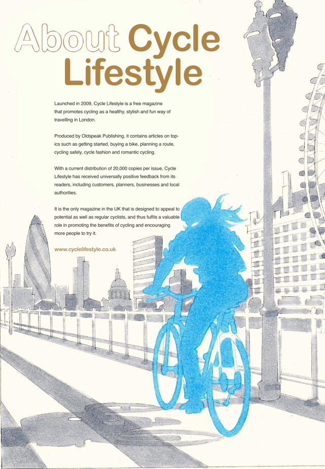
Launched in 2009, Cycle Lifestyle is a free magazine that promotes cycling as a healthy, stylish and fun way of travelling in London.
Produced by Oldspeak Publishing, it contains articles on top-ics such as getting started, buying a bike, planning a route, cycling safely, cycle fashion and romantic cycling.
With a current distribution of 20,000 copies per issue, Cycle Lifestyle has received universally positive feedback from its readers, including customers, planners, businesses and local authorities. It is the only magazine in the UK that is designed to appeal to
more people to try it.
!!!"#$#%&%'(&)*$%&"#+",-
./+,*01$#%&2'(&)*$%&
Recommended