GREEN BEAN DESIGN l a n d s c a p e a r c h i t e c t s
Liverpool Range Wind Farm Landscape and Visual Impact Assessment – Addendum Report February 2017
1
LIVERPOOL RANGE WIND FARM
Addendum Report Prepared for:
EPURON PTY LTD Prepared by:
GREEN BEAN DESIGN PTY LTD PO Box 3178 Austral NSW 2179 Principal: Andy Homewood BSc (Dual Hons), DipLM, DipHort, Registered Landscape Architect, AILA (ABN: 86 603 575 702)
February 2017
GREEN BEAN DESIGN l a n d s c a p e a r c h i t e c t s

GREEN BEAN DESIGN l a n d s c a p e a r c h i t e c t s
Liverpool Range Wind Farm Landscape and Visual Impact Assessment – Addendum Report February 2017
2
DOUCMENT CONTROL
ITEM DETAIL
Project Name: Liverpool Range Wind Farm
Report Title: Addendum Report
Project Number: 15‐195
Version Number: v2
Status: Final
Author:
Andrew Homewood, Registered Landscape Architect, AILA
Graduate Diploma Landscape Management, Bachelor Science (Dual Honours)
Landscape and Archaeology, National Diploma Horticulture
Date 12 February 2017
Green Bean Design – Capability statement
Green Bean Design (GBD) was established as a landscape architectural consultancy in 1999 and has
specialised in landscape and visual impact assessment over the past 10 years. As an independent
consultancy, GBD provide professional advice to a wide range of commercial and government clients
involved in large infrastructure project development.
GBD owner, and principal landscape architect Andrew Homewood, is a registered landscape architect and
member of the Australian Institute of Landscape Architects and the Environmental Institute of Australia
and New Zealand. Andrew has over 22 years continuous employment in landscape consultancy and has
completed numerous landscape and visual impact assessments for a variety of large scale and state
significant infrastructure, including mines, transmission lines/substations, wind farms and solar power
developments.

GREEN BEAN DESIGN l a n d s c a p e a r c h i t e c t s
Liverpool Range Wind Farm Landscape and Visual Impact Assessment – Addendum Report February 2017
3
Introduction
This response to submission has been prepared further to submissions from the public, organisations and
government agencies, including comments provided by the NSW Department of Planning and Environment
in July 2016.
This Addendum Report addresses the concerns and provides further details on potential visual impacts
identified in the Liverpool Range Wind Farm Landscape and Visual Impact Assessment March 2014.
The NSW Department of Planning and Environment response noted that:
‘a photomontage or justification as to why a photomontage is not required (e.g. further consultation and/or
assessment has occurred) may be required to address any gaps in the original assessment identified in
submissions’.
The Addendum Report has adopted wireframe models, rather than photomontage, to illustrate the location
and number of wind turbines which may be visible from dwelling locations. For the purpose of this
Addendum Report wireframes are considered preferential to photomontages as they:
Allow a wider view angle to be presented without loss of clarity
Clearly identify wind turbines screened by landform alone therefore representing a very conservative
outcome
Illustrate distant wind turbines (in excess of 5 kilometres) which may not be readily visible in a
photomontage.
The preparation of wireframe diagrams is also supported by the Scottish Natural Heritage Guidelines ‘Visual
Representation of Wind Farms’ version 2.1 December 2014. The Scottish Guidelines note that wireframes
are:
‘computer generated line drawings, based on a Digital Terrain Model, that indicate the three‐dimensional
shape of the landscape in combination with additional elements. They are a valuable tool in the wind farm
LVIA process as they allow the assessor to compare the position and scale of the turbines to the existing
landscape’.
The Scottish Guidelines also note that wireframes are:
‘particularly useful to the landscape architect or experienced specialist assessor as they portray objective
data. This means that, by comparing wireframes with views on the site, the assessor can make judgements
on the likely visual impacts in a variety of environmental conditions, safe in the knowledge that the
wireframes have not been subject to manipulation that cannot be quantified. They can also reveal what
would be visible if an existing screening element, for example vegetation or building, were removed’.
GREEN BEAN DESIGN l a n d s c a p e a r c h i t e c t s
Liverpool Range Wind Farm Landscape and Visual Impact Assessment – Addendum Report February 2017
4
The preparation of this Addendum Report included the following key tasks:
Site inspections
Meetings and discussions with residents
Preparation of wireframes
Detailed desk top assessment
Preparation of additional figures.
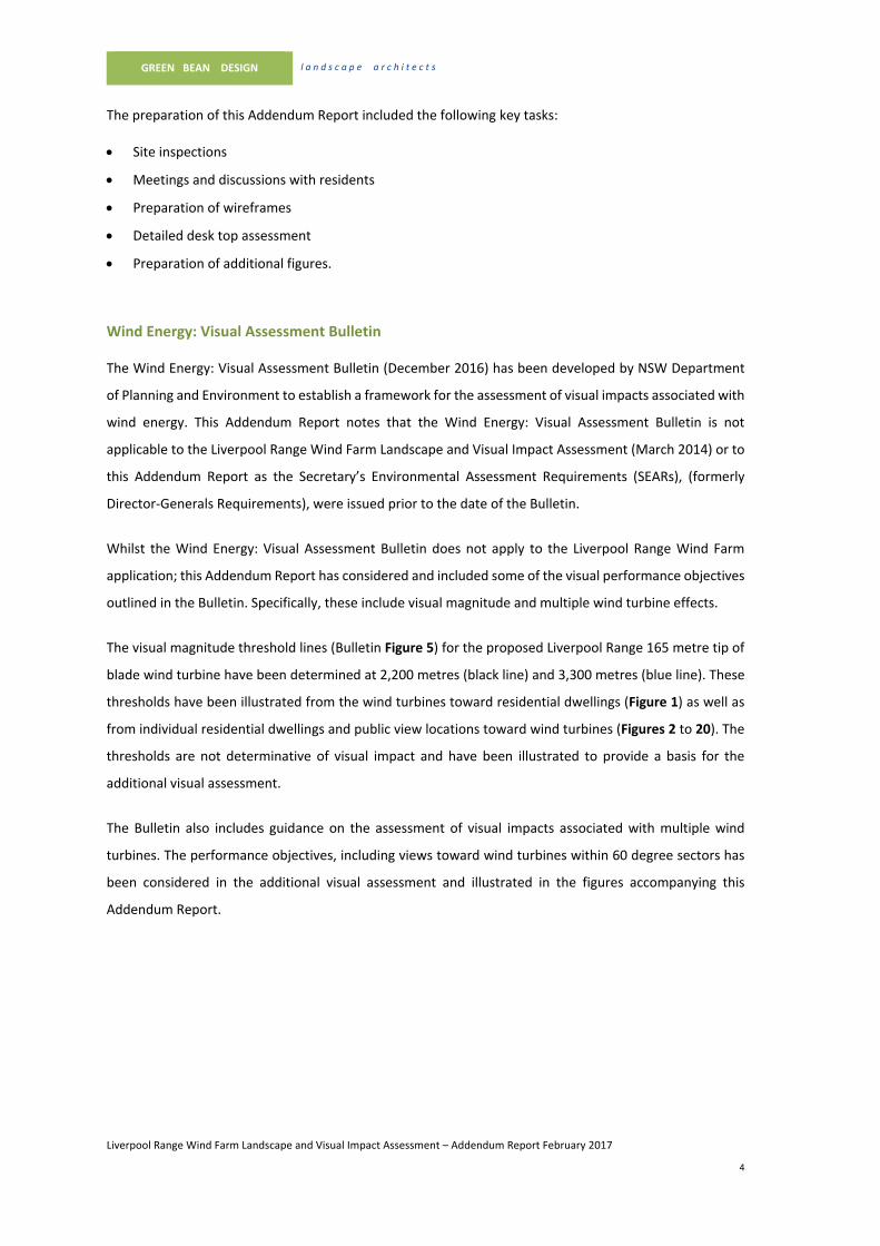
Wind Energy: Visual Assessment Bulletin
The Wind Energy: Visual Assessment Bulletin (December 2016) has been developed by NSW Department
of Planning and Environment to establish a framework for the assessment of visual impacts associated with
wind energy. This Addendum Report notes that the Wind Energy: Visual Assessment Bulletin is not
applicable to the Liverpool Range Wind Farm Landscape and Visual Impact Assessment (March 2014) or to
this Addendum Report as the Secretary’s Environmental Assessment Requirements (SEARs), (formerly
Director‐Generals Requirements), were issued prior to the date of the Bulletin.
Whilst the Wind Energy: Visual Assessment Bulletin does not apply to the Liverpool Range Wind Farm
application; this Addendum Report has considered and included some of the visual performance objectives
outlined in the Bulletin. Specifically, these include visual magnitude and multiple wind turbine effects.
The visual magnitude threshold lines (Bulletin Figure 5) for the proposed Liverpool Range 165 metre tip of
blade wind turbine have been determined at 2,200 metres (black line) and 3,300 metres (blue line). These
thresholds have been illustrated from the wind turbines toward residential dwellings (Figure 1) as well as
from individual residential dwellings and public view locations toward wind turbines (Figures 2 to 20). The
thresholds are not determinative of visual impact and have been illustrated to provide a basis for the
additional visual assessment.
The Bulletin also includes guidance on the assessment of visual impacts associated with multiple wind
turbines. The performance objectives, including views toward wind turbines within 60 degree sectors has
been considered in the additional visual assessment and illustrated in the figures accompanying this
Addendum Report.

GREEN BEAN DESIGN l a n d s c a p e a r c h i t e c t s
Liverpool Range Wind Farm Landscape and Visual Impact Assessment – Addendum Report February 2017
5
Site inspection and consultation
The Addendum Report has incorporated the results of further site inspections and meetings with involved
and uninvolved property owners within and surrounding the wind farm site boundary. Table 1 outlines the
results of site inspections carried out in November 2016, and discussions with residents surrounding the
proposed Liverpool Range Wind Farm. The dwelling locations included in Table 1 are illustrated on Figure
1.

D7-3
D7-4
C6-1
C6-3
C6-4
C7-1
Cassilis
Coolah
D4-9
H7-1
G6-2
F8-1
2km
C4-1
C4-8
C4-5
C4-9
C5-6
C5-9
D7-2
G6-3
F9-1
E9-4
H6-3
2.2km
3.3km
2.2km
2.2km
2.2km
2.2km
2.2km
3.3km
3.3km
3.3km
3.3km
3.3km
C2-4
C2-3
Involved dwelling
Distance from proposed Liverpool
Range wind turbine
Proposed 330 kV powerline route
within wind farm project area
Uninvolved dwelling
Proposed Liverpool Range wind turbine
(indicative location)
Figure 1
Residential dwelling locations
LIVERPOOL RANGE WIND FARM
Legend
0km 5km
Source: C
opyright C
om
monw
ealth of A
ustralia (G
eoscience A
ustralia) 2017 http://m
apconnect.ga.gov.au/M
apC
onnect/250K
/

GREEN BEAN DESIGN l a n d s c a p e a r c h i t e c t s
Liverpool Range Wind Farm Landscape and Visual Impact Assessment – Addendum Report February 2017
7
Table 1 – Site inspection and consultation record
Dwelling
ID
Name Involved or
uninvolved
Site
inspection
Comments
C2‐3 and
C2‐4
Binnia Hills Uninvolved 10/11/2016 Two dwellings on property. C2‐3
veranda oriented North‐West and
heavily screened to the south in
direction of turbine locations. Photo
taken from paddock between house
and shed. C2‐4 is situated in a valley
and completely screened from the
project.
Additional assessment undertaken
C4‐1 Winooka Uninvolved 10/11/2016 Additional assessment undertaken
C4‐5 Gundare Uninvolved 10/11/2016 Photo taken from front of house. House
situated quite high up. Visual impact
not a big concern.
Additional assessment undertaken
C4‐8 Uninvolved 9/11/2016 No tree screening exists. Photo taken
from front yard. The veranda is
orientated to the south east. There is
no permanent resident, however the
dwelling is used frequently.
Additional assessment undertaken
C4‐9 Leeton Uninvolved 10/11/2016 No one living there. House dilapidated.
Some screening around house. Photo
taken from back of house near the
shed.
Additional assessment undertaken

GREEN BEAN DESIGN l a n d s c a p e a r c h i t e c t s
Liverpool Range Wind Farm Landscape and Visual Impact Assessment – Addendum Report February 2017
8
Table 1 – Site inspection and consultation record
Dwelling
ID
Name Involved or
uninvolved
Site
inspection
Comments
C5‐6 Kurralah Uninvolved 10/11/2016 Photo taken from side of house. House
currently not inhabited but intending to
rent out in the future.
Additional assessment undertaken
C5‐9 Willania Uninvolved 9/11/2016 House quite well screened. Photo taken
from edge of back yard. No real concern
over visual impact.
Additional assessment undertaken
C6‐1 Sunnyside Involved No additional assessment undertaken
C6‐3 Collie Blue Uninvolved 11/03/2016 Additional assessment undertaken
C6‐4 Brooksby Involved No additional assessment undertaken
C7‐1 Wilandra Involved No additional assessment undertaken
D4‐9 Gynawah Involved 9/11/2016 Involved landowner with construction
compound and then neighbour
agreement. Photo taken from
front/back of house.
Additional assessment undertaken
D7‐2 Involved No additional assessment undertaken
D7‐3 Tallue 9/11/2016 Visited, house fully screened. A
photomontage was offered but agreed

GREEN BEAN DESIGN l a n d s c a p e a r c h i t e c t s
Liverpool Range Wind Farm Landscape and Visual Impact Assessment – Addendum Report February 2017
9
Table 1 – Site inspection and consultation record
Dwelling
ID
Name Involved or
uninvolved
Site
inspection
Comments
as not necessary due to screening
extent.
No additional assessment undertaken
D7‐4 Cooinda Uninvolved Additional assessment undertaken
E9‐4 Rangeview Uninvolved 9/11/2016 Photos taken from water tank. E9‐4
being rented out. Owners had no
concerns.
F8‐1 Tangaratta Involved Property has been sold to involved
landowner.
No additional assessment undertaken
F9‐1 Culbara Uninvolved Additional assessment undertaken
G6‐2 Glenwood Uninvolved Additional assessment undertaken
G6‐3 Ellaroy Uninvolved Additional assessment undertaken
H6‐3 Uninvolved 10/11/2016 No concerns, didn’t feel the need for
photos to be taken. Would see a very
small number of turbines at most.
No additional assessment undertaken
H7‐1 St Antoine Uninvolved 10/11/2016 Additional assessment undertaken

GREEN BEAN DESIGN l a n d s c a p e a r c h i t e c t s
Liverpool Range Wind Farm Landscape and Visual Impact Assessment – Addendum Report February 2017
10
Additional visual assessment This Addendum Report has undertaken additional visual assessment of dwellings identified in the NSW
Department of Planning and Environment response to submission. This has incorporated the results of additional
site work and further detailed desk top assessment including the provision of wire frame models.
Uninvolved dwellings C2‐3 and C2‐4 (Binnia Hills)
LVIA V3 March 2014
The LVIA V3 March 2014 included an assessment of dwellings C2‐3 and C2‐4 within view location L5 located
around 4.8 kilometres to the east of the Mullaley Coolah Road. The LVIA V3 March 2014 noted that ‘Views from
residential properties will be largely restricted to wind turbines elevated along the northern edge of the project
area’. The LVIA V3 March 2014 determined that dwellings within view location L5 would be subject to a medium
level of visual effect.
Further visual assessment:
A further assessment for dwelling C2‐4 has determined that the dwelling is located on the lower portion of a
north facing slope. The sloping landform extending above the dwelling is likely to screen views from the dwelling
and surrounding garden toward the proposed wind turbines. The C2‐3 wireframe model (Figure 2) illustrates
that around 18 wind turbines would be visible from hub height (and below). Visibility from the C2‐3 dwelling
would be partially restricted by a row of mature trees around 35 metres to the east of the dwelling. The
wireframe model also indicates that wind turbines would be visible within two 60o sectors.
Further visual assessment has determined that dwelling C2‐4 is unlikely to be directly impacted by the wind farm
and that dwelling C2‐3 would be subject to a low to medium visual effect.
Wireframe:
Figure 2, C2‐3 wireframe information:
Wireframe start bearing: 75°, Wireframe end bearing: 186°
Tips visible: 22
Hubs visible: 18
Closest turbine: Turbine #91 ‐ 3,265m
Note: The number of visible wind turbine tips and hubs depicted in the wireframe model does not take into
account the location and potential screening influence of existing tree cover, including planting proximate to, or
beyond, residential dwellings.

2.2km
3.3km
78
°
78°
60°
60°
60°
60°
60°
60°
Residential dwelling C2-3 wireframe.
Approximate 78 degree field of view south east from residential dwelling C2-3. Distance to closest wind turbine (#91) 3,265 metres. Visibility does not account for existing tree cover between dwelling and wind turbine, including
existing tree planting within proximity to the residential dwelling. Blue wind turbines are visible or partially visible to tip of blade. Red wind turbines are screened by landform.
Residential dwelling C2-3 location plan
Figure 2 Dwelling C2-3
Wireframe analysis
LIVERPOOL RANGE WIND FARM
0 km 1 km
Residential dwelling C2-3 aerial oblique.
The aerial oblique illustrates typical landform characteristics and location of
existing tree cover between C2-3 and surrounding wind turbines. The extent
of wind turbines illustrated in the aerial oblique does not represent the
potential visibility of wind turbines from the dwelling.
Turbine #84Turbine #91Turbine #109
Note:
The landform illustrated in the green wireframe model occurs between the
residential dwelling and the wind turbines. Sections of blue wind turbines will
not be visible where indicated within or below the green wireframe
model.Views will only extend toward sections of blue wind turbines where
they occur above the green wireframe model.
Turbine #95
Turbine #106
Turbine #45Turbine #97Turbine #93
Turbine #98
Turbine #109
Turbine #110 Turbine #121
Turbine #101
Turbine #89 Turbine #91
Turbine #86 Turbine #84
Turbine #100
C2-3
Tips visible
Go
og
le
E
arth
P
ro
, 2
01
6 C
NE
S/A
striu
m 2
01
7
Go
og
le
E
arth
P
ro
, 2
01
6 C
NE
S/A
striu
m 2
01
7

GREEN BEAN DESIGN l a n d s c a p e a r c h i t e c t s
Liverpool Range Wind Farm Landscape and Visual Impact Assessment – Addendum Report February 2017
12
Uninvolved dwelling C4‐1 (Winooka)
LVIA V3 March 2014
The LVIA V3 March 2014 included an assessment of dwelling C4‐1 within view location L4 located to the west of
the Gundare Road. The LVIA V3 March 2014 noted that ‘Views extent along and across valleys toward wind
turbines located on hilltop and ridgeline areas. Some residential dwellings will have partial screening through
tree planting surrounding dwellings’. The LVIA V3 March 2014 determined that dwellings within view location
L4 would be subject to a medium level of visual effect.
Further visual assessment:
A supplementary assessment for dwelling C4‐1 has determined that the dwelling is located on gently sloping
land above a drainage line. This location affords medium to long distance views to surrounding ridgeline
locations. The C4‐1 wireframe model (Figure 3) illustrates that around 54 wind turbines would be visible from
hub height (and below). Visibility from the C4‐1 dwelling is generally open, however scattered tree planting
surrounding the dwelling will provide some degree of visual filtering toward the wind turbines. The wireframe
model also indicates that wind turbines would be visible up to a distance of around 6 kilometres within one 60o
sector.
Further visual assessment has determined that dwelling C4‐1 is unlikely to be significantly impacted by the wind
farm and that dwelling C4‐1 would be subject to a medium visual effect in accordance with the LVIA V3 March
2014 determination.
Wireframe:
Figure 3, C4‐1 wireframe information:
Start bearing: 30°, End bearing: 170°
Tips visible: 72
Hubs visible: 54
Closest turbine: Turbine #116 ‐ 3,631m
Note: The number of visible wind turbine tips and hubs depicted in the wireframe model does not take into
account the location and potential screening influence of existing tree cover, including planting proximate to, or
beyond, residential dwellings.

2.2km
3.3km
11°
60°
60°
60°
60°
60°
60°
6km
11°
Residential dwelling C4-1 wireframe.
Approximate 11 degree field of view north east from residential dwelling C4-1. Distance to closest wind turbine (#116) 3,631 metres. Visibility does not account for existing tree cover between dwelling and wind turbine, including
existing tree planting within proximity to the residential dwelling. Blue wind turbines are visible or partially visible to tip of blade. Red wind turbines are screened by landform.
Residential dwelling C4-1 location plan
Figure 3 Dwelling C4-1
Wireframe analysis
LIVERPOOL RANGE WIND FARM
0 km 2 km
Turbine #116
Turbine #116
Turbine #42 (Hub)
Turbines in excess of 6 km from C4-1
C4-1
Wind turbines screened by landform
Residential dwelling C4-1 aerial oblique.
The aerial oblique illustrates typical landform characteristics and location of
existing tree cover between C4-1 and surrounding wind turbines. The extent
of wind turbines illustrated in the aerial oblique does not represent the
potential visibility of wind turbines from the dwelling.
Note:
The landform illustrated in the green wireframe model occurs between the
residential dwelling and the wind turbines. Sections of blue wind turbines will
not be visible where indicated within or below the green wireframe
model.Views will only extend toward sections of blue wind turbines where
they occur above the green wireframe model.
Go
og
le
E
arth
P
ro
, 2
01
6 C
NE
S/A
striu
m 2
01
7
Go
og
le
E
arth
P
ro
, 2
01
6 C
NE
S/A
striu
m 2
01
7
Turbine #5Turbine #19
(Tip)

GREEN BEAN DESIGN l a n d s c a p e a r c h i t e c t s
Liverpool Range Wind Farm Landscape and Visual Impact Assessment – Addendum Report February 2017
14
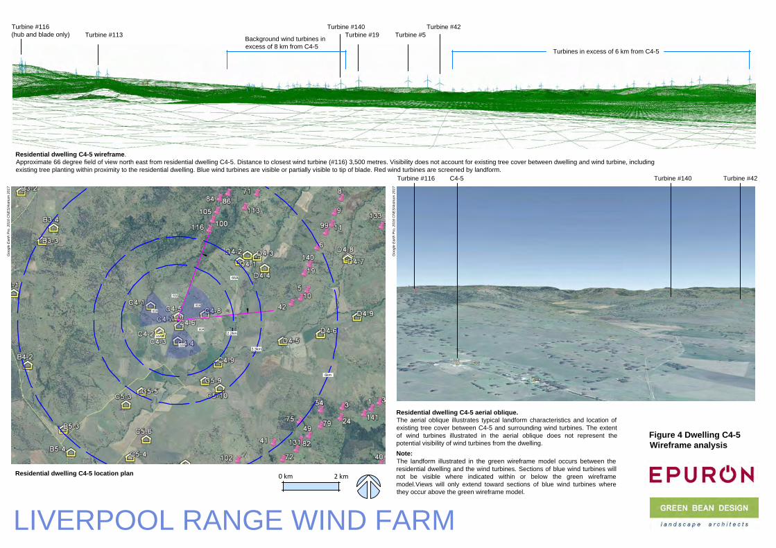
Uninvolved dwelling C4‐5 (Gundare)
LVIA V3 March 2014
The LVIA V3 March 2014 included an assessment of dwelling C4‐5 within view location L4 located to the west of
the Gundare Road. The LVIA V3 March 2014 noted that ‘Views extent along and across valleys toward wind
turbines located on hilltop and ridgeline areas. Some residential dwellings will have partial screening through
tree planting surrounding dwellings’. The LVIA V3 March 2014 determined that dwellings within view location
L4 would be subject to a medium level of visual effect.
Further visual assessment:
A supplementary assessment for dwelling C4‐5 has determined that the dwelling is located on top of a low
undulation within the broader valley floor. This location affords medium to long distance views to surrounding
ridgeline locations. The C4‐5 wireframe model (Figure 4) illustrates that around 93 wind turbines would be visible
from hub height (and below). Visibility from the C4‐5 dwelling is generally open; however, the owners have
indicated no particular concerns with regard to the potential for visual effects. The wireframe model also
indicates that wind turbines would be visible up to a distance of around 6 kilometres within two 60o sectors.
Further visual assessment has determined that dwelling C4‐5 is unlikely to be significantly impacted by the wind
farm and that dwelling C4‐5 would be subject to a medium visual effect in accordance with the LVIA V3 March
2014 determination.
Wireframe:
Figure 4, C4‐5 wireframe information:
Start bearing: 20°, End bearing: 173°
Tips visible: 128
Hubs visible: 93
Closest turbine: Turbine #116 ‐ 3,500m
Note: The number of visible wind turbine tips and hubs depicted in the wireframe model does not take into
account the location and potential screening influence of existing tree cover, including planting proximate to, or
beyond, residential dwellings.
2.2km
3.3km
64°
66°
60°
60°
60°
60°
60°
60°
6km
Residential dwelling C4-5 wireframe.
Approximate 66 degree field of view north east from residential dwelling C4-5. Distance to closest wind turbine (#116) 3,500 metres. Visibility does not account for existing tree cover between dwelling and wind turbine, including
existing tree planting within proximity to the residential dwelling. Blue wind turbines are visible or partially visible to tip of blade. Red wind turbines are screened by landform.
Residential dwelling C4-5 location plan
Figure 4 Dwelling C4-5
Wireframe analysis
LIVERPOOL RANGE WIND FARM
0 km 2 km
Turbine #42Turbine #140Turbine #116
Turbine #5Turbine #113
Turbine #116
(hub and blade only)
Turbine #42
Turbines in excess of 6 km from C4-5
C4-5
Turbine #19
Turbine #140
Background wind turbines in
excess of 8 km from C4-5
Residential dwelling C4-5 aerial oblique.
The aerial oblique illustrates typical landform characteristics and location of
existing tree cover between C4-5 and surrounding wind turbines. The extent
of wind turbines illustrated in the aerial oblique does not represent the
potential visibility of wind turbines from the dwelling.
Note:
The landform illustrated in the green wireframe model occurs between the
residential dwelling and the wind turbines. Sections of blue wind turbines will
not be visible where indicated within or below the green wireframe
model.Views will only extend toward sections of blue wind turbines where
they occur above the green wireframe model.
Go
og
le
E
arth
P
ro
, 2
01
6 C
NE
S/A
striu
m 2
01
7
Go
og
le
E
arth
P
ro
, 2
01
6 C
NE
S/A
striu
m 2
01
7

GREEN BEAN DESIGN l a n d s c a p e a r c h i t e c t s
Liverpool Range Wind Farm Landscape and Visual Impact Assessment – Addendum Report February 2017
16
Uninvolved dwelling C4‐8
LVIA V3 March 2014
The LVIA V3 March 2014 included an assessment of dwelling C4‐8 within view location L4 located to the west of
the Gundare Road. The LVIA V3 March 2014 noted that ‘Views extent along and across valleys toward wind
turbines located on hilltop and ridgeline areas. Some residential dwellings will have partial screening through
tree planting surrounding dwellings’. The LVIA V3 March 2014 determined that dwellings within view location
L4 would be subject to a medium level of visual effect.
Further visual assessment:
A supplementary assessment for dwelling C4‐8 notes that the dwelling is located on a sloping hillside above the
adjoining valley floor. This location affords medium to long distance views to surrounding ridgeline locations.
The C4‐8 wireframe analysis (Figure 5) illustrates that around 113 wind turbines would be visible from hub height
(and below). Visibility from the C4‐8 dwelling is generally open with views extending from the closest wind
turbine at 3,200 metres to more distant groupings at 5.5 kilometres and 7.5 kilometres. The wireframe model
also indicates that wind turbines would be visible up to a distance around 5.5 kilometres within two 60o sectors.
Further visual assessment has determined that dwelling C4‐8 is likely to be impacted by the wind farm and that
dwelling C4‐8 would be subject to a medium to high visual effect.
Wireframe:
Figure 5, C4‐8 wireframe information:
Start bearing: 1°, End bearing: 182°
Tips visible: 130
Hubs visible: 113
Closest turbine: Turbine #116 ‐ 3,200m
Note: Note: The number of visible wind turbine tips and hubs depicted in the wireframe model does not take
into account the location and potential screening influence of existing tree cover, including planting proximate
to, or beyond, residential dwellings.
Potential for mitigation:
The potential visual effect of wind turbines is considered possible through appropriate landscape screening
works. Any landscape mitigation would be required within proximity to the dwelling and its curtilage which
would possibly result in the reduction and/or screening of existing medium and long distance views from the
dwelling and its immediate surrounds.

2.2km
3.3km
60°
60°
60°
60°
60°
81°
81°
60°
5.5km
Residential dwelling C4-8 wireframe.
Approximate 81 degree field of view north east from residential dwelling C4-8. Distance to closest wind turbine (#116) 3,200 metres. Visibility does not account for existing tree cover between dwelling and
wind turbine, including existing tree planting within proximity to the residential dwelling. Blue wind turbines are visible or partially visible to tip of blade. Red wind turbines are screened by landform.
Residential dwelling C4-8 location plan
Figure 5 Dwelling C4-8
Wireframe analysis
LIVERPOOL RANGE WIND FARM
Turbine #42Turbine #140Turbine #116
Turbine #5Turbine #113
Turbine #42
Turbines in excess of 5.5 km from C4-8
C4-8
Turbine #19
Turbine #140
Background wind turbines in excess of 7.5 km from C4-8
Turbine #116
Residential dwelling C4-8 aerial oblique.
The aerial oblique illustrates typical landform characteristics and location of
existing tree cover between C4-8 and surrounding wind turbines. The extent
of wind turbines illustrated in the aerial oblique does not represent the
potential visibility of wind turbines from the dwelling.
Note:
The landform illustrated in the green wireframe model occurs between the
residential dwelling and the wind turbines. Sections of blue wind turbines will
not be visible where indicated within or below the green wireframe
model.Views will only extend toward sections of blue wind turbines where
they occur above the green wireframe model.
0 km 2 km
Go
og
le
E
arth
P
ro
, 2
01
6 C
NE
S/A
striu
m 2
01
7
Go
og
le
E
arth
P
ro
, 2
01
6 C
NE
S/A
striu
m 2
01
7

GREEN BEAN DESIGN l a n d s c a p e a r c h i t e c t s
Liverpool Range Wind Farm Landscape and Visual Impact Assessment – Addendum Report February 2017
18
Uninvolved dwelling C4‐9 (Leeton)
LVIA V3 March 2014
The LVIA V3 March 2014 included an assessment of dwelling C4‐9 within view location L4 located to the south
of Coolah Creek Road. The LVIA V3 March 2014 noted that ‘Views extent along and across valleys toward wind
turbines located on hilltop and ridgeline areas. Some residential dwellings will have partial screening through
tree planting surrounding dwellings’. The LVIA V3 March 2014 determined that dwellings within view location
L4 would be subject to a medium level of visual effect.
Further visual assessment:
A supplementary assessment for dwelling C4‐9 notes that the dwelling is located to the south of the Coolah
Creek Road on relatively level land with a broad valley floor. This location affords medium to long distance views
to surrounding ridgeline locations with some visual filtering provided by scattered mature tree cover
surrounding the dwelling.
The C4‐9 wireframe model (Figure 6) illustrates that around 115 wind turbines would be visible from hub height
(and below). Visibility from the C4‐9 dwelling is partially screened by tree cover with views extending from the
closest wind turbine at around 3,582 metres to more distant groupings in excess of 4 kilometres and 8
kilometres. The wireframe model also indicates that wind turbines would be visible up to a distance around 4
kilometres within two 60o sectors.
Further visual assessment has determined that dwelling C4‐9 is likely to be impacted by the wind farm and that
dwelling C4‐9 would be subject to a medium visual effect in accordance with the LVIA V3 March 2014.
Wireframe:
Figure 6, C4‐9 wireframe information:
Start bearing: 357°, End bearing: 197°
Tips visible: 145
Hubs visible: 115
Closest turbine: Turbine #42 ‐ 3,582m
Note: The number of visible wind turbine tips and hubs depicted in the wireframe model does not take into
account the location and potential screening influence of existing tree cover, including planting proximate to, or
beyond, residential dwellings.

2.2km
3.3km
55°
55°
55°
55°
60°
60°
60°
60°
60°
60°
Residential dwelling C4-9 wireframe.
Approximate 55 degree field of view north east and south east from residential dwelling C4-9. Distance to closest wind turbine (#42) 3,582 metres. Visibility does not account for existing tree cover between dwelling and wind turbine,
including existing tree planting within proximity to the residential dwelling. Blue wind turbines are visible or partially visible to tip of blade. Red wind turbines are screened by landform.
Residential dwelling C4-9 location plan
Figure 6 Dwelling C4-9
Wireframe analysis
LIVERPOOL RANGE WIND FARM
Turbine #42Turbine #113Turbine #116
Turbine #42
Turbine #10
Turbines generally in excess of 4 km from C4-9
C4-9
Background wind turbines in excess of 8 km from C4-9
Turbine #19Turbine #71Turbine #116 Turbine #91
Residential dwelling C4-9 aerial oblique.
The aerial oblique illustrates typical landform characteristics and location of
existing tree cover between C4-9 and surrounding wind turbines. The extent
of wind turbines illustrated in the aerial oblique does not represent the
potential visibility of wind turbines from the dwelling.
Note:
The landform illustrated in the green wireframe model occurs between the
residential dwelling and the wind turbines. Sections of blue wind turbines will
not be visible where indicated within or below the green wireframe
model.Views will only extend toward sections of blue wind turbines where
they occur above the green wireframe model.
0 km 2 km
Go
og
le
E
arth
P
ro
, 2
01
6 C
NE
S/A
striu
m 2
01
7
Go
og
le
E
arth
P
ro
, 2
01
6 C
NE
S/A
striu
m 2
01
7

GREEN BEAN DESIGN l a n d s c a p e a r c h i t e c t s
Liverpool Range Wind Farm Landscape and Visual Impact Assessment – Addendum Report February 2017
20
Uninvolved dwelling C5‐6 (Kurralah)
LVIA V3 March 2014
The LVIA V3 March 2014 included an assessment of dwelling C5‐6 within view location L4 located to the south
of Coolah Creek Road. The LVIA V3 March 2014 noted that ‘Views extent along and across valleys toward wind
turbines located on hilltop and ridgeline areas. Some residential dwellings will have partial screening through
tree planting surrounding dwellings’. The LVIA V3 March 2014 determined that dwellings within view location
L4 would be subject to a medium level of visual effect.
Further visual assessment:
A supplementary assessment for dwelling C5‐6 notes that the dwelling is located to the south of the Coolah
Creek Road on relatively level to gently sloping land above the Coolah Creek line. This location affords
opportunities for medium to long distance views to surrounding ridgeline locations. Some visual filtering is
provided by scattered mature tree cover surrounding the dwelling.
The C5‐6 wireframe model (Figure 7) illustrates that around 76 wind turbines would be visible from hub height
(and below). Visibility from the C5‐6 dwelling is partially screened by tree cover with views extending from the
closest wind turbine at around 3,561 metres to more distant groupings including those in excess of 9 kilometres
from dwelling C5‐6. The wireframe model also indicates that wind turbines would be visible within one 60o
sector.
Further visual assessment has determined that dwelling C5‐6 is likely to be impacted by the wind farm and that
dwelling C5‐6 would be subject to a medium visual effect in accordance with the LVIA V3 March 2014.
Wireframe:
Figure 7, C5‐6 wireframe information:
Start bearing: 0°, End bearing: 182°
Tips visible: 141
Hubs visible: 113
Closest turbine: Turbine #102 ‐ 3,561m
Note: The number of visible wind turbine tips and hubs depicted in the wireframe model does not take into
account the location and potential screening influence of existing tree cover, including planting proximate to, or
beyond, residential dwellings.

2.2km
3.3km
40°
40°
60°
60°
60°
60°
60°
60°
Residential dwelling C5-6 wireframe.
Approximate 40 degree field of view east to south east from residential dwelling C5-6. Distance to closest wind turbine (#102) 3,561 metres. Visibility does not account for existing tree cover between dwelling and wind turbine, including
existing tree planting within proximity to the residential dwelling. Blue wind turbines are visible or partially visible to tip of blade. Red wind turbines are screened by landform.
Residential dwelling C5-6 location plan
Figure 7 Dwelling C5-6
Wireframe analysis
LIVERPOOL RANGE WIND FARM
Turbine #23Turbine #102Turbine #41
Turbine #102
C5-6
Background wind turbines in
excess of 9 km from C5-6
Turbine #36 Turbine #27 Turbine #66
Turbine #73
Turbine #61
Turbine #66 Turbine #73
Residential dwelling C5-6 aerial oblique.
The aerial oblique illustrates typical landform characteristics and location of
existing tree cover between C5-6 and surrounding wind turbines. The extent
of wind turbines illustrated in the aerial oblique does not represent the
potential visibility of wind turbines from the dwelling.
Note:
The landform illustrated in the green wireframe model occurs between the
residential dwelling and the wind turbines. Sections of blue wind turbines will
not be visible where indicated within or below the green wireframe
model.Views will only extend toward sections of blue wind turbines where
they occur above the green wireframe model.
0 km 2 km
Go
og
le
E
arth
P
ro
, 2
01
6 C
NE
S/A
striu
m 2
01
7
Go
og
le
E
arth
P
ro
, 2
01
6 C
NE
S/A
striu
m 2
01
7

GREEN BEAN DESIGN l a n d s c a p e a r c h i t e c t s
Liverpool Range Wind Farm Landscape and Visual Impact Assessment – Addendum Report February 2017
22
Uninvolved dwelling C5‐9 (Willania)
LVIA V3 March 2014
The LVIA V3 March 2014 included an assessment of dwelling C5‐9 within view location L4 located to the south
of Coolah Creek Road. The LVIA V3 March 2014 noted that ‘Views extent along and across valleys toward wind
turbines located on hilltop and ridgeline areas. Some residential dwellings will have partial screening through
tree planting surrounding dwellings’. The LVIA V3 March 2014 determined that dwellings within view location
L4 would be subject to a medium level of visual effect.
Further visual assessment:
A supplementary assessment for dwelling C5‐9 notes that the dwelling is located to the south of the Coolah
Creek Road on relatively level to gently sloping land above the Coolah Creek line. This location affords
opportunities for medium to long distance views to surrounding ridgeline locations. Some visual filtering is
provided by scattered mature tree cover surrounding the dwelling.
The C5‐9 wireframe model (Figure 8) illustrates that around 76 wind turbines would be visible from hub height
(and below). Visibility from the C5‐9 dwelling is partially screened by tree cover with views extending from the
closest wind turbine at around 3,229 metres to more distant groupings including those in excess of 9 kilometres
from dwelling C5‐9. The wireframe model also indicates that wind turbines would be visible within two 60o
sectors.
Further visual assessment has determined that dwelling C5‐9 is likely to be impacted by the wind farm and that
dwelling C5‐9 would be subject to a medium visual effect in accordance with the LVIA V3 March 2014.
Wireframe:
Figure 8, C5‐9 wireframe information:
Start bearing: 15°, End bearing: 155°
Tips visible: 86
Hubs visible: 76
Closest turbine: Turbine #102 ‐ 3,229m
Note: The number of visible wind turbine tips and hubs depicted in the wireframe model does not take into
account the location and potential screening influence of existing tree cover, including planting proximate to, or
beyond, residential dwellings.

2.2km
3.3km
72°
72°
60°
60°
60°
60°
60°
60°
Residential dwelling C5-9 wireframe.
Approximate 72 degree field of view south east from residential dwelling C5-9. Distance to closest wind turbine (#102) 3,229 metres. Visibility does not account for existing tree cover between dwelling and wind turbine, including
existing tree planting within proximity to the residential dwelling. Blue wind turbines are visible or partially visible to tip of blade. Red wind turbines are screened by landform.
Residential dwelling C5-9 location plan
Figure 8 Dwelling C5-9
Wireframe analysis
LIVERPOOL RANGE WIND FARM
Turbine #66Turbine #75 Turbine #41
Turbine #41
C5-9
Background wind turbines in
excess of 9 km from C5-9
Turbine #65
Turbine #102
Turbine #61
Turbine #66 Turbine #102
Turbine #90
Turbine #56Turbine #131
Turbine #82Turbine #75
Turbine #131
Residential dwelling C5-9 aerial oblique.
The aerial oblique illustrates typical landform characteristics and location of
existing tree cover between C5-9 and surrounding wind turbines. The extent
of wind turbines illustrated in the aerial oblique does not represent the
potential visibility of wind turbines from the dwelling.
Note:
The landform illustrated in the green wireframe model occurs between the
residential dwelling and the wind turbines. Sections of blue wind turbines will
not be visible where indicated within or below the green wireframe
model.Views will only extend toward sections of blue wind turbines where
they occur above the green wireframe model.
0 km 2 km
Go
og
le
E
arth
P
ro
, 2
01
6 C
NE
S/A
striu
m 2
01
7
Go
og
le
E
arth
P
ro
, 2
01
6 C
NE
S/A
striu
m 2
01
7
Turbine #54

GREEN BEAN DESIGN l a n d s c a p e a r c h i t e c t s
Liverpool Range Wind Farm Landscape and Visual Impact Assessment – Addendum Report February 2017
24
Uninvolved dwelling C6‐3 (Collie Blue)
LVIA V3 March 2014
The LVIA V3 March 2014 included an assessment of dwelling C6‐3 within view location L3 located to the north
of Cassilis Road. The LVIA V3 March 2014 noted that ‘Views will extend along and across valleys toward wind
turbines located on hilltop and ridgeline areas. Some residential dwellings will have partial screening through
tree planting surrounding dwellings’. The LVIA V3 March 2014 determined that dwellings within view location
L3 would be subject to a medium level of visual effect.
Further visual assessment:
A supplementary assessment for dwelling C6‐3 notes that the dwelling is located north and adjacent to the
Cassilis Road corridor on a gently sloping landform. This location affords opportunities for medium to long
distance views to surrounding ridgeline locations. The C6‐3 wireframe model (Figure 9) illustrate that around 28
wind turbines would be visible from hub height (and below). Views will extend toward the closest wind turbine
at around 2,284 metres to more distant groupings from dwelling C6‐3. The wireframe model also indicates that
wind turbines would be visible within two 60o sectors.
Further visual assessment has determined that dwelling C6‐3 is likely to be impacted by the wind farm and that
dwelling C6‐3 would be subject to a medium visual effect in accordance with the LVIA V3 March 2014.
Wireframe:
Figure 9, C6‐3 wireframe information:
Start bearing: 365°, End bearing: 135°
Tips visible: 58
Hubs visible: 28
Closest turbine: Turbine #23 ‐ 2,284m
Note: The number of visible wind turbine tips and hubs depicted in the wireframe model does not take into
account the location and potential screening influence of existing tree cover, including planting proximate to, or
beyond, residential dwellings.

2.2km
3.3km
70°
60°
60°
60°
60°
60°
60°
70°
Residential dwelling C6-3 wireframe.
Approximate 70 degree field of view south east from residential dwelling C6-3. Distance to closest wind turbine (#23) 2,284 metres. Visibility does not account for existing tree cover between dwelling and wind turbine, including
existing tree planting within proximity to the residential dwelling. Blue wind turbines are visible or partially visible to tip of blade. Red wind turbines are screened by landform.
Residential dwelling C6-3 location plan
Figure 9 Dwelling C6-3
Wireframe analysis
LIVERPOOL RANGE WIND FARM
Turbine #126Turbine #23 Turbine #52
Turbine #53
C6-3
Turbine #126
Turbine #55
Turbine #77Turbine #23
Residential dwelling C6-3 aerial oblique.
The aerial oblique illustrates typical landform characteristics and location of
existing tree cover between C6-3 and surrounding wind turbines. The extent
of wind turbines illustrated in the aerial oblique does not represent the
potential visibility of wind turbines from the dwelling.
Note:
The landform illustrated in the green wireframe model occurs between the
residential dwelling and the wind turbines. Sections of blue wind turbines will
not be visible where indicated within or below the green wireframe
model.Views will only extend toward sections of blue wind turbines where
they occur above the green wireframe model.
0 km 2 km
Go
og
le
E
arth
P
ro
, 2
01
6 C
NE
S/A
striu
m 2
01
7
Go
og
le
E
arth
P
ro
, 2
01
6 C
NE
S/A
striu
m 2
01
7
Turbine #52

GREEN BEAN DESIGN l a n d s c a p e a r c h i t e c t s
Liverpool Range Wind Farm Landscape and Visual Impact Assessment – Addendum Report February 2017
26
Involved dwelling D4‐9 (Gynawah)
LVIA V3 March 2014
The LVIA V3 March 2014 included an assessment of dwelling D4‐9. The LVIA V3 March 2014 noted that ‘short
distance views extend toward wind turbines along surrounding ridgelines’. The LVIA V3 March 2014 determined
that the D4‐9 dwelling would be subject to a medium to high level of visual effect.
Further visual assessment:
A supplementary assessment for dwelling D4‐9 notes that the dwelling is located south and adjacent to the
Coolah Creek Road on relatively level ground above the Coolah Creek line. This location affords opportunities
for medium to long distance views to surrounding ridgeline locations.
The D4‐9 wireframe model (Figures 10 and 11) illustrate that around 78 wind turbines would be visible from hub
height (and below). Views will extend toward the closest wind turbine at around 2,200 metres to more distant
groupings including those in excess of 6.5 kilometres from dwelling D4‐9.
Further visual assessment has determined that dwelling D4‐9 is likely to be impacted by the wind farm and that
dwelling D4‐9 would be subject to a medium to high visual effect in accordance with the LVIA V3 March 2014.
This assessment also notes that dwelling D4‐9 is an involved landowner.
Wireframe:
Figures 10 and 11, D4‐9 wireframe information:
Start bearing: 278°, End bearing: 226°
Tips visible: 98
Hubs visible: 78
Closest turbine: Turbine #10 ‐ 2,200m (north to north west) Turbine #136 – 2,830 (south east).
Note: The number of visible wind turbine tips and hubs depicted in the wireframe model does not take into
account the location and potential screening influence of existing tree cover, including planting proximate to, or
beyond, residential dwellings.

2.2km
3.3km
122°
122°
60°
60°
60°
60°
60°
60°
Residential dwelling D4-9 wireframe.
Approximate 122 degree field of view north west to north east from residential dwelling D4-9. Distance to closest wind turbine (#10) 2,200 metres. Visibility does not account for existing tree cover between
dwelling and wind turbine, including existing tree planting within proximity to the residential dwelling. Blue wind turbines are visible or partially visible to tip of blade. Red wind turbines are screened by landform.
Residential dwelling D4-9 location plan
Figure 10 D4-9
Wireframe analysis
LIVERPOOL RANGE WIND FARM
Turbine #37Turbine #10
Turbine #129
D4-9
Background wind turbines in
excess of 6.5 km from D4-9
Turbine #139Turbine #10
Turbine #42
Turbine #5
Turbine #19 Turbine #140 Turbine #6
Background wind turbines in
excess of 6.5 km from D4-9
Turbine #62 Turbine #37
Turbine #6
Residential dwelling D4-9 aerial oblique.
The aerial oblique illustrates typical landform characteristics and location of
existing tree cover between D4-9 and surrounding wind turbines. The extent
of wind turbines illustrated in the aerial oblique does not represent the
potential visibility of wind turbines from the dwelling.
Note:
The landform illustrated in the green wireframe model occurs between the
residential dwelling and the wind turbines. Sections of blue wind turbines will
not be visible where indicated within or below the green wireframe
model.Views will only extend toward sections of blue wind turbines where
they occur above the green wireframe model.
0 km 2 km
Go
og
le
E
arth
P
ro
, 2
01
6 C
NE
S/A
striu
m 2
01
7
Go
og
le
E
arth
P
ro
, 2
01
6 C
NE
S/A
striu
m 2
01
7

2.2km
3.3km
38°
38°
60°
60°
60°
60°
60°
60°
Residential dwelling D4-9 wireframe.
Approximate 38 degree field of view south east from residential dwelling D4-9. Distance to closest wind turbine (#136) 2,860 metres. Visibility does not account for existing tree cover between dwelling and
wind turbine, including existing tree planting within proximity to the residential dwelling. Blue wind turbines are visible or partially visible to tip of blade. Red wind turbines are screened by landform.
Residential dwelling D4-9 location plan
Figure 11 D4-9
Wireframe analysis
LIVERPOOL RANGE WIND FARM
Turbine #47Turbine #136
Turbine #62
D4-9
Background wind turbines in
excess of 6.5 km from D4-9
Turbine #139
Turbine #37
Turbine #136Turbine #20Turbine #34
Background wind turbines in excess of 3.5 km from D4-9
Residential dwelling D4-9 aerial oblique.
The aerial oblique illustrates typical landform characteristics and location of
existing tree cover between D4-9 and surrounding wind turbines. The extent
of wind turbines illustrated in the aerial oblique does not represent the
potential visibility of wind turbines from the dwelling.
Note:
The landform illustrated in the green wireframe model occurs between the
residential dwelling and the wind turbines. Sections of blue wind turbines will
not be visible where indicated within or below the green wireframe
model.Views will only extend toward sections of blue wind turbines where
they occur above the green wireframe model.
0 km 2 km
Go
og
le
E
arth
P
ro
, 2
01
6 C
NE
S/A
striu
m 2
01
7
Go
og
le
E
arth
P
ro
, 2
01
6 C
NE
S/A
striu
m 2
01
7

GREEN BEAN DESIGN l a n d s c a p e a r c h i t e c t s
Liverpool Range Wind Farm Landscape and Visual Impact Assessment – Addendum Report February 2017
29
Involved dwelling D7‐2
LVIA V3 March 2014
The LVIA V3 March 2014 included an assessment of dwelling D7‐2 within view location L2 located to the west of
Turee Vale Road. The LVIA V3 March 2014 noted that for view location L2 ‘views will extend along and across
valleys toward wind turbines located on hilltop and ridgeline areas. Some residential dwellings will have partial
screening through tree planting surrounding dwellings’. The LVIA V3 March 2014 determined that the L2 view
location would be subject to a medium level of visual effect.
Further visual assessment:
A supplementary assessment for dwelling D7‐2 notes that the dwelling is located west and adjacent to the Turee
Vale Road on gently sloping ground above the Turee Creek line. This location affords opportunities for medium
to long distance views to surrounding ridgeline locations; however, views toward wind turbines to the west of
Turee Creek will be partially screened by landform rising to the north of the dwelling as well as mature tree
planting around the dwelling.
The D7‐2 wireframe model (Figure 12) illustrates that around 76 wind turbines would be visible from hub height
(and below). Views will extend toward the closest wind turbine at around 4,280 metres to more distant
groupings including those in excess of 7 kilometres from dwelling D7‐2. The wireframe model also indicates that
wind turbines would be visible within two 60o sectors.
Further visual assessment has determined that dwelling D7‐2 is likely to be impacted by the wind farm and that
dwelling D7‐2 would be subject to a medium visual effect in accordance with the LVIA V3 March 2014. This
assessment also notes that dwelling D7‐2 is subject to an agreement.
Wireframe:
Figure 12, D7‐2 wireframe information:
Start bearing: 320°, End bearing: 140°
Tips visible:107
Hubs visible:76
Closest turbine: Turbine #201 ‐ 4,280
Note: The number of visible wind turbine tips and hubs depicted in the wireframe model does not take into
account the location and potential screening influence of existing tree cover, including planting proximate to, or
beyond, residential dwellings.

2.2km
3.3km
69°
69°
60°
60°
60°
60°
60°
60°
Residential dwelling D7-2 wireframe.
Approximate 69 degree field of view north from residential dwelling D7-2. Distance to closest wind turbine (#201) 4,280 metres. Visibility does not account for existing tree cover between dwelling and wind turbine, including
existing tree planting within proximity to the residential dwelling. Blue wind turbines are visible or partially visible to tip of blade. Red wind turbines are screened by landform.
Residential dwelling D7-2 location plan
Figure 12 Dwelling D7-2
Wireframe analysis
LIVERPOOL RANGE WIND FARM
Turbine #201
Turbine #201
D7-2
Background wind turbines in
excess of 7 km from D7-2
Turbine #126
Wind turbines screened by landform
Residential dwelling D7-2 aerial oblique.
The aerial oblique illustrates typical landform characteristics and location of
existing tree cover between D7-2 and surrounding wind turbines. The extent
of wind turbines illustrated in the aerial oblique does not represent the
potential visibility of wind turbines from the dwelling.
Note:
The landform illustrated in the green wireframe model occurs between the
residential dwelling and the wind turbines. Sections of blue wind turbines will
not be visible where indicated within or below the green wireframe
model.Views will only extend toward sections of blue wind turbines where
they occur above the green wireframe model.
0 km 2 km
Go
og
le
E
arth
P
ro
, 2
01
6 C
NE
S/A
striu
m 2
01
7
Go
og
le
E
arth
P
ro
, 2
01
6 C
NE
S/A
striu
m 2
01
7
Turbine #126

GREEN BEAN DESIGN l a n d s c a p e a r c h i t e c t s
Liverpool Range Wind Farm Landscape and Visual Impact Assessment – Addendum Report February 2017
31
Uninvolved dwelling D7‐4 (Cooinda)
LVIA V3 March 2014
The LVIA V3 March 2014 included an assessment of dwelling D7‐4 within view location L2 located to the west of
Turee Vale Road. The LVIA V3 March 2014 noted that for view location L2 ‘views will extend along and across
valleys toward wind turbines located on hilltop and ridgeline areas. Some residential dwellings will have partial
screening through tree planting surrounding dwellings’. The LVIA V3 March 2014 determined that the L2 view
location would be subject to a medium level of visual effect.
Further visual assessment:
A supplementary assessment for dwelling D7‐4 notes that the dwelling is located west and adjacent to the Turee
Vale Road on gently sloping ground above the Turee Creek line. This location affords opportunities for medium
distance views to surrounding ridgeline locations; however, views toward wind turbines to the west of Turee
Creek and north of the dwelling will be partially screened by landform rising to the north as well as mature tree
planting beyond the dwelling.
The D7‐4 wireframe analysis (Figure 13) illustrates that around 39 wind turbines would be visible from hub height
(and below). Views will extend toward the closest wind turbine at around 2,920 metres to more distant
groupings including those in excess of 6.5 kilometres from dwelling D7‐4. The wireframe model also indicates
that wind turbines would be visible within one 60o sector.
Further visual assessment has determined that dwelling D7‐4 is likely to be impacted by the wind farm and that
dwelling D7‐4 would be subject to a medium visual effect in accordance with the LVIA V3 March 2014.
Wireframe:
Figure 13, D7‐4 wireframe information:
Start bearing: 304°, End bearing: 150°
Tips visible: 50
Hubs visible: 39
Closest turbine: Turbine #201 ‐ 2,926m
Note: The number of visible wind turbine tips and hubs depicted in the wireframe model does not take into
account the location and potential screening influence of existing tree cover, including planting proximate to, or
beyond, residential dwellings.

2.2km
3.3km
27°
27°60°
60°
60°
60°
60°
60°
Residential dwelling D7-4 wireframe.
Approximate 27 degree field of view north west to north east from residential dwelling D7-4. Distance to closest wind turbine (#201) 2,962 metres. Visibility does not account for existing tree cover between dwelling and wind turbine, including
existing tree planting within proximity to the residential dwelling. Blue wind turbines are visible or partially visible to tip of blade. Red wind turbines are screened by landform.
Residential dwelling D7-4 location plan
Figure 13 Dwelling D7-4
Wireframe analysis
LIVERPOOL RANGE WIND FARM
Turbine #201Turbine #175
D7-4
Turbine #201
Background wind turbines in
excess of 7 km from D7-4
Turbine #219
Wind turbines screened by landform
Residential dwelling D7-4 aerial oblique.
The aerial oblique illustrates typical landform characteristics and location of
existing tree cover between D7-4 and surrounding wind turbines. The extent
of wind turbines illustrated in the aerial oblique does not represent the
potential visibility of wind turbines from the dwelling.
Note:
The landform illustrated in the green wireframe model occurs between the
residential dwelling and the wind turbines. Sections of blue wind turbines will
not be visible where indicated within or below the green wireframe
model.Views will only extend toward sections of blue wind turbines where
they occur above the green wireframe model.
0 km 2 km
Turbine #191
Go
og
le
E
arth
P
ro
, 2
01
6 C
NE
S/A
striu
m 2
01
7
Go
og
le
E
arth
P
ro
, 2
01
6 C
NE
S/A
striu
m 2
01
7
Turbine #175

GREEN BEAN DESIGN l a n d s c a p e a r c h i t e c t s
Liverpool Range Wind Farm Landscape and Visual Impact Assessment – Addendum Report February 2017
33
Uninvolved dwelling E9‐4 (Rangeview)
LVIA V3 March 2014
The LVIA V3 March 2014 included an assessment of dwelling E9‐4 within view location L2 located to the east of
Cassilis Road. The LVIA V3 March 2014 noted that for view location L2 ‘views will extend along and across valleys
toward wind turbines located on hilltop and ridgeline areas. Some residential dwellings will have partial screening
through tree planting surrounding dwellings’. The LVIA V3 March 2014 determined that the L2 view location
would be subject to a medium level of visual effect.
Further visual assessment:
A supplementary assessment for dwelling E9‐4 notes that the dwelling is located to the east and above the
Cassilis Road corridor, on top of a low timbered spur extending north south. This location affords opportunities
for medium to long distance views to surrounding ridgeline locations. However, views toward wind turbines will
be partially screened by landform as well as mature scattered tree planting beyond the dwelling.
The E9‐4 wireframe model (Figure 14) illustrates that around 39 wind turbines would be visible from hub height
(and below). Views will extend toward the closest wind turbine at around 4,000 metres from dwelling E9‐4. The
wireframe model also indicates that wind turbines would be visible within one 60o sector.
Further visual assessment has determined that dwelling E9‐4 is unlikely to be significantly impacted by the wind
farm and that dwelling E9‐4 would be subject to a low to medium visual effect.
Wireframe:
Figure 14, E9‐4 wireframe information:
Start bearing: 304°, End bearing: 150°
Tips visible: 50
Hubs visible: 39
Closest turbine: Turbine #237 – 4,000m
Note: The number of visible wind turbine tips and hubs depicted in the wireframe model does not take into
account the location and potential screening influence of existing tree cover, including planting proximate to, or
beyond, residential dwellings.

2.2km
3.3km
59°59°
60°
60°
60°
60°
60°
60°
Residential dwelling E9-4 wireframe.
Approximate 59 degree field of view east from residential dwelling E9-4. Distance to closest wind turbine (#237) 4,000 metres. Visibility does not account for existing tree cover between dwelling and wind turbine, including
existing tree planting within proximity to the residential dwelling. Blue wind turbines are visible or partially visible to tip of blade. Red wind turbines are screened by landform.
Residential dwelling E9-4 location plan
Figure 14 Dwelling E9-4
Wireframe analysis
LIVERPOOL RANGE WIND FARM
Turbine #237
Turbine #284
E9-4
Turbine #277
Background wind turbines in excess of 8 km from E9-4
Turbine #265
Wind turbines screened by landform
Residential dwelling E9-4 aerial oblique.
The aerial oblique illustrates typical landform characteristics and location of
existing tree cover between E9-4 and surrounding wind turbines. The extent
of wind turbines illustrated in the aerial oblique does not represent the
potential visibility of wind turbines from the dwelling.
Note:
The landform illustrated in the green wireframe model occurs between the
residential dwelling and the wind turbines. Sections of blue wind turbines will
not be visible where indicated within or below the green wireframe
model.Views will only extend toward sections of blue wind turbines where
they occur above the green wireframe model.
0 km 2 km
Turbine #277
Turbine #237
Turbine #285Turbine #276
Background wind turbines in excess of 8 km from E9-4
Go
og
le
E
arth
P
ro
, 2
01
6 C
NE
S/A
striu
m 2
01
7
Go
og
le
E
arth
P
ro
, 2
01
6 C
NE
S/A
striu
m 2
01
7

GREEN BEAN DESIGN l a n d s c a p e a r c h i t e c t s
Liverpool Range Wind Farm Landscape and Visual Impact Assessment – Addendum Report February 2017
35
Uninvolved dwelling F9‐1 (Culbara)
LVIA V3 March 2014
The LVIA V3 March 2014 included an assessment of dwelling F9‐1 within view location L2 located to the south
of Coolah Road.
The LVIA V3 March 2014 noted that for view location L2 ‘views will extend along and across valleys toward wind
turbines located on hilltop and ridgeline areas. Some residential dwellings will have partial screening through
tree planting surrounding dwellings’.
The LVIA V3 March 2014 determined that the L2 view location would be subject to a medium level of visual
effect.
Further visual assessment:
A supplementary assessment for dwelling F9‐1 notes that the dwelling is located to the south of the Coolah Road
corridor, on gently sloping land. This location affords opportunities for medium to long distance views to
surrounding ridgeline locations. However, views toward wind turbines will be partially screened by landform as
well as mature scattered tree planting surrounding and beyond the dwelling.
The F9‐1 wireframe model (Figure 15) illustrates that around 8 wind turbines would be visible from hub height
(and below). Views will extend toward the closest wind turbine at around 2,337 metres from dwelling F9‐1. The
wireframe model also indicates that wind turbines would be visible within one 60o sector.
Further visual assessment has determined that dwelling F9‐1 is unlikely to be significantly impacted by the wind
farm and that dwelling F9‐1 would be subject to a low to medium visual effect.
Wireframe:
Figure 15, F9‐1 wireframe information:
Start bearing: 314°, End bearing: 80°
Tips visible: 10
Hubs visible: 8
Closest turbine: Turbine #279 ‐ 2,337m
Note: The number of visible wind turbine tips and hubs depicted in the wireframe model does not take into
account the location and potential screening influence of existing tree cover, including planting proximate to, or
beyond, residential dwellings.

2.2km
3.3km
49°
49°
60°
60°
60°
60°
60°
60°
Residential dwelling F9-1 wireframe.
Approximate 49 degree field of view north east from residential dwelling F9-1. Distance to closest wind turbine (#279) 2,337 metres. Visibility does not account for existing tree cover between dwelling and wind turbine, including
existing tree planting within proximity to the residential dwelling. Blue wind turbines are visible or partially visible to tip of blade. Red wind turbines are screened by landform.
Residential dwelling F9-1 location plan
Figure 15 Dwelling F9-1
Wireframe analysis
LIVERPOOL RANGE WIND FARM
Turbine #277
Turbine #237
F9-1
Turbine #279
Turbine #265
Residential dwelling F9-1 aerial oblique.
The aerial oblique illustrates typical landform characteristics and location of
existing tree cover between F9-1 and surrounding wind turbines. The extent
of wind turbines illustrated in the aerial oblique does not represent the
potential visibility of wind turbines from the dwelling.
Note:
The landform illustrated in the green wireframe model occurs between the
residential dwelling and the wind turbines. Sections of blue wind turbines will
not be visible where indicated within or below the green wireframe
model.Views will only extend toward sections of blue wind turbines where
they occur above the green wireframe model.
0 km 2 km
Turbine #279
Turbine #277
Turbine #274Turbine #243
Turbine #237
Go
og
le
E
arth
P
ro
, 2
01
6 C
NE
S/A
striu
m 2
01
7
Go
og
le
E
arth
P
ro
, 2
01
6 C
NE
S/A
striu
m 2
01
7

GREEN BEAN DESIGN l a n d s c a p e a r c h i t e c t s
Liverpool Range Wind Farm Landscape and Visual Impact Assessment – Addendum Report February 2017
37
Uninvolved dwelling G6‐2 (Glenwood)
LVIA V3 March 2014
The LVIA V3 March 2014 included an assessment of dwelling G6‐2.
The LVIA V3 March 2014 noted that ‘The property has been purchased as an environmental offset and the
residential dwelling is unoccupied. Views toward the closest wind turbines are partially screened by vegetation
surrounding the residential dwelling’.
The LVIA V3 March 2014 determined that the G6‐2 dwelling would be subject to a low to medium level of visual
effect.
Further visual assessment:
A supplementary assessment for dwelling G6‐2 notes that the dwelling is located to the west of the Yarrawonga
Road corridor, on generally level land. This location affords opportunities for medium to long distance views to
surrounding ridgeline locations. However, views toward wind turbines will be partially screened by a rising
landform as well as mature scattered tree planting surrounding and beyond the dwelling.
The G6‐2 wireframe model (Figure 16) illustrates that around 12 wind turbines would be visible from hub height
(and below). Views will extend toward the closest wind turbine at around 1,974 metres from dwelling G6‐2. The
wireframe model also indicates that wind turbines would be visible within one 60o sector.
Further visual assessment has determined that dwelling G6‐2 is unlikely to be significantly impacted by the wind
farm and that dwelling G6‐2 would be subject to a low to medium visual effect.
Wireframe:
Figure 16, G6‐2 wireframe information:
Start bearing: 134°, End bearing: 6°
Tips visible: 17
Hubs visible: 12
Closest turbine: Turbine #224 ‐ 1,974m
Note: The number of visible wind turbine tips and hubs depicted in the wireframe model does not take into
account the location and potential screening influence of existing tree cover, including planting proximate to, or
beyond, residential dwellings.

2.2km
3.3km
56°
56°
60°
60°
60°
60°
60°
60°
Residential dwelling G6-2 wireframe.
Approximate 56 degree field of view north west from residential dwelling G6-2. Distance to closest wind turbine (#224) 1,974 metres. Visibility does not account for existing tree cover between dwelling and wind turbine, including
existing tree planting within proximity to the residential dwelling. Blue wind turbines are visible or partially visible to tip of blade. Red wind turbines are screened by landform.
Residential dwelling G6-2 location plan
Figure 16 Dwelling G6-2
Wireframe analysis
LIVERPOOL RANGE WIND FARM
Turbine #214
Turbine #224
G6-2
Turbine #214
Turbine #224
Residential dwelling G6-2 aerial oblique.
The aerial oblique illustrates typical landform characteristics and location of
existing tree cover between G6-2 and surrounding wind turbines. The extent
of wind turbines illustrated in the aerial oblique does not represent the
potential visibility of wind turbines from the dwelling.
Note:
The landform illustrated in the green wireframe model occurs between the
residential dwelling and the wind turbines. Sections of blue wind turbines will
not be visible where indicated within or below the green wireframe
model.Views will only extend toward sections of blue wind turbines where
they occur above the green wireframe model.
0 km 2 km
Turbine #168
Turbine #186
Turbine #168Turbine #186
Go
og
le
E
arth
P
ro
, 2
01
6 C
NE
S/A
striu
m 2
01
7
Go
og
le
E
arth
P
ro
, 2
01
6 C
NE
S/A
striu
m 2
01
7

GREEN BEAN DESIGN l a n d s c a p e a r c h i t e c t s
Liverpool Range Wind Farm Landscape and Visual Impact Assessment – Addendum Report February 2017
39
Uninvolved dwelling G6‐3 (Ellaroy)
LVIA V3 March 2014
The LVIA V3 March 2014 included an assessment of dwelling G6‐3 within view location L1 located to the north
of Yarrawonga Road.
The LVIA V3 March 2014 noted that for view location L1 ‘views toward turbines within the south portion of the
project area will be partially screened through a combination of landform and tree cover’.
The LVIA V3 March 2014 determined that the L1 view location would be subject to a low to medium level of
visual effect.
Further visual assessment:
A supplementary assessment for dwelling G6‐3 notes that the dwelling is located to the north of the Yarrawonga
Road corridor, on gently rising land. This location affords opportunities for medium to long distance views to
surrounding ridgeline locations. However, views toward wind turbines will be partially screened by a rising
landform as well as mature scattered tree planting surrounding and beyond the dwelling.
The G6‐3 wireframe model (Figure 17) illustrates that around 9 wind turbines would be visible from hub height
(and below). Views will extend toward the closest wind turbine at around 2,249 metres from dwelling G6‐3. The
wireframe model also indicates that wind turbines would be visible within one 60o sector.
Further visual assessment has determined that dwelling G6‐3 is unlikely to be significantly impacted by the wind
farm and that dwelling G6‐3 would be subject to a low to medium visual effect in accordance with the LVIA V3
March 2014.
Wireframe:
Figure 17, G6‐3 wireframe information:
Start bearing: 177°, End bearing: 6°
Tips visible: 13
Hubs visible: 9
Closest turbine: Turbine #214 ‐ 2,249m
Note: The number of visible wind turbine tips and hubs depicted in the wireframe model does not take into
account the location and potential screening influence of existing tree cover, including planting proximate to, or
beyond, residential dwellings.

2.2km
3.3km
11°
11°
60°
60°
60°
60°
60°
60°
Residential dwelling G6-3 wireframe.
Approximate 11 degree field of view west from residential dwelling G6-3. Distance to closest wind turbine (#214) 2,249 metres. Visibility does not account for existing tree cover between dwelling and wind turbine, including
existing tree planting within proximity to the residential dwelling. Blue wind turbines are visible or partially visible to tip of blade. Red wind turbines are screened by landform.
Residential dwelling G6-3 location plan
Figure 17 Dwelling G6-3
Wireframe analysis
LIVERPOOL RANGE WIND FARM
Turbine #214
G6-3
Residential dwelling G6-3 aerial oblique.
The aerial oblique illustrates typical landform characteristics and location of
existing tree cover between G6-3 and surrounding wind turbines. The extent
of wind turbines illustrated in the aerial oblique does not represent the
potential visibility of wind turbines from the dwelling.
Note:
The landform illustrated in the green wireframe model occurs between the
residential dwelling and the wind turbines. Sections of blue wind turbines will
not be visible where indicated within or below the green wireframe
model.Views will only extend toward sections of blue wind turbines where
they occur above the green wireframe model.
0 km 2 km
Turbine #168
Turbine #214Turbine #168
Go
og
le
E
arth
P
ro
, 2
01
6 C
NE
S/A
striu
m 2
01
7
Go
og
le
E
arth
P
ro
, 2
01
6 C
NE
S/A
striu
m 2
01
7
GREEN BEAN DESIGN l a n d s c a p e a r c h i t e c t s
Liverpool Range Wind Farm Landscape and Visual Impact Assessment – Addendum Report February 2017
41
Uninvolved dwelling H7‐1 (St Antoine)
LVIA V3 March 2014
The LVIA V3 March 2014 included an assessment of dwelling H7‐1.
The LVIA V3 March 2014 noted that for view location H7‐1 ‘The property has been purchased as an
environmental offset and the residential dwelling is unoccupied. Views toward the closest wind turbines are
screened by topography and vegetation surrounding the residential dwelling. Views toward the closest visible
turbines occur from the east side of the property at a distance of around 2,900 m’.
The LVIA V3 March 2014 determined that the H7‐1 view location would be subject to a low level of visual effect.
Further visual assessment:
A supplementary assessment for dwelling H7‐1 notes that the dwelling is located to the east of the wind farm
project, on gently rising land. This location affords possible opportunities for medium to long distance views to
surrounding ridgeline locations. However, views are generally constrained by slopes and ridgelines within the
valley where the dwelling is located. Views toward wind turbines will be largely screened by a rising landform as
well as mature scattered tree planting surrounding and beyond the dwelling.
The H7‐1 wireframe model (Figure 18) illustrates that around 6 wind turbines would be visible from hub height
(and below). Views will extend toward the closest wind turbine (tip of blade only) at around 1,795 metres from
dwelling H7‐1. The wireframe model also indicates that wind turbines would be visible within one 60o sector.
Further visual assessment has determined that dwelling H7‐1 is unlikely to be significantly impacted by the wind
farm and that dwelling H7‐1 would be subject to a low visual effect in accordance with the LVIA V3 March 2014.
Wireframe:
Figure 18, H7‐1 wireframe information:
Start bearing: 200°, End bearing: 360°
Tips visible: 7
Hubs visible: 6
Closest turbine: Turbine #240 ‐ 1,795m (tip of blade only)
Note: The number of visible wind turbine tips and hubs depicted in the wireframe model does not take into
account the location and potential screening influence of existing tree cover, including planting proximate to, or
beyond, residential dwellings.

2.2km
3.3km
16°
16°
60°
60°
60°
60°
60°
60°
Residential dwelling H7-1 wireframe.
Approximate 16 degree field of view north from residential dwelling H7-1. Distance to closest wind turbine (#240) 1,795 metres. Visibility does not account for existing tree cover between dwelling and wind turbine, including
existing tree planting within proximity to the residential dwelling. Blue wind turbines are visible or partially visible to tip of blade. Red wind turbines are screened by landform.
Residential dwelling H7-1 location plan
Figure 18 Dwelling H7-1
Wireframe analysis
LIVERPOOL RANGE WIND FARM
Turbine #245
H7-1
Residential dwelling H7-1 aerial oblique.
The aerial oblique illustrates typical landform characteristics and location of
existing tree cover between H7-1 and surrounding wind turbines. The extent
of wind turbines illustrated in the aerial oblique does not represent the
potential visibility of wind turbines from the dwelling.
Note:
The landform illustrated in the green wireframe model occurs between the
residential dwelling and the wind turbines. Sections of blue wind turbines will
not be visible where indicated within or below the green wireframe
model.Views will only extend toward sections of blue wind turbines where
they occur above the green wireframe model.
0 km 2 km
Turbine #236
Turbine #245
Turbine #249
Turbine #240 (tip only)
Turbine #236
Go
og
le
E
arth
P
ro
, 2
01
6 C
NE
S/A
striu
m 2
01
7
Go
og
le
E
arth
P
ro
, 2
01
6 C
NE
S/A
striu
m 2
01
7
GREEN BEAN DESIGN l a n d s c a p e a r c h i t e c t s
Liverpool Range Wind Farm Landscape and Visual Impact Assessment – Addendum Report February 2017
43
Uninvolved dwelling 36 Charles Street, Coolah
LVIA V3 March 2014
The LVIA V3 March 2014 included an assessment of dwellings within Coolah. The LVIA V3 March 2014 noted
that:
‘Coolah is a small town to the west and approximately 6.5 km from the closest Liverpool Range wind turbine. The
town is located to the west of the Coolaburragundy River valley and rises gently to the west toward a timbered
undulating landform. There are various opportunities to gain long distance views toward a small number of wind
turbines within the central west portion of the wind farm site; however, views from many of the streets within
Coolah are screened and partially filtered by street tree planting and trees within residential properties.
The Liverpool Range wind farm is not expected to have a significant visual impact on residential dwellings and
public view locations within the Cassilis and Coolah localities. This is primarily due to the screening influence of
undulating landform, tree cover within the urban areas, as well as the distance between the wind farm and
potential view locations within these rural localities’.
The LVIA V3 March 2014 determined that residential dwellings within the Coolah township would be subject to
a low level of visual effect.
Further visual assessment:
A supplementary assessment for the dwelling at 36 Charles Street notes that the dwelling is located to the south
of Charles Street in an east to west orientation and is parallel to the Charles Street road corridor. Views from
within the dwelling are generally screened by tree and shrub planting beyond the dwelling, with no windows
directly aligned to the wind farm project. Views toward the nearest wind turbine (#61) from the garden at a
distance around 7,200m, will also be partially obscured by tree and shrub planting. Where wind turbines are
visible, the potential magnitude of visual effect will be minimised by the distance between the dwelling and the
wind turbine locations.
Further visual assessment has determined that dwelling 36 Charles Street is unlikely to be significantly impacted
by the wind farm and that dwelling 36 Charles Street would be subject to a very low visual effect.
Figure 19 illustrates the locality of 36 Charles Street, the existing road corridor view toward the wind farm site
adjacent to 36 Charles Street, and the photomontage from Coolah included in the LVIA V3 March 2014 report.

2.2km
3.3km
8km
L10
SSENNE ENE ENE ESE SE
20° 30° 40° 50° 60° 70° 80° 90° 100° 110° 120° 130° 140° 150° 160°
170°
36 Charles Street, Coolah location plan
Figure 19
36 Charles St, Coolah
LIVERPOOL RANGE WIND FARM
36 Charles Street, Coolah
The photograph illustrates typical landform characteristics and location of
existing tree cover between 36 Charles Street, Coolah and distant wind
turbines.
0 km 2 km
Public view location L10 Coolah - Proposed view through 120Á. Approximate distance to closest visible wind turbine 5.9 km
36 Charles St, CoolahCharles St, Coolah
Go
og
le
E
arth
P
ro
, 2
01
6 C
NE
S/A
striu
m 2
01
7
Go
og
le
E
arth
P
ro
, 2
01
6 C
NE
S/A
striu
m 2
01
7

GREEN BEAN DESIGN l a n d s c a p e a r c h i t e c t s
Liverpool Range Wind Farm Landscape and Visual Impact Assessment – Addendum Report February 2017
45
Main roads leading into Coolah
The LVIA V3 March 2014 noted that:
There are a small number of local roads that pass through the wind farm Project area including the:
Rotherwood Road;
Turee Creek Road;
Coolah Creek Road; and
Gundaree Road.
Views from vehicles travelling along local roads within the Project site will include a combination of very short to
long distance direct and indirect views toward wind turbines. Whilst wind turbines may be visible whilst driving
through the Project site, it is likely that the majority of journeys within the Project site will be those undertaken
by residents involved with the Project.
Views from the Cassilis, Coolah and Vinegaroy Roads (between the Golden Highway, Cassilis and Coolah) will
include direct and indirect views toward wind turbines in the south and central portions of the Project area up to
a distance of 2km and 5 km from the wind turbines. The potential visibility of the Project will decrease slightly for
vehicles travelling north west to south east.
Views from small portions of the road corridor between Coolah and Cassilis will be screened by landform and/or
tree planting alongside or beyond the road corridor. The Liverpool Range wind farm will be unlikely to have a
significant visual impact on motorists travelling along the Cassilis and Coolah roads.
The Golden Highway extends east to west below the Project area between a distance of 5 km and 10 km from
the closest wind turbine and provides a sequence of contained and open views from the road corridor. Distant
and very short duration views toward wind turbines in the south portion of the Project area will occur from a
section of the highway between Borambil and Cassilis, but will not tend to result in a significant visual impact.
Views toward the proposed wind farm site from the Leadville Road corridor (south of Coolah) will be partially
screened by gently undulating landform rising above the Coolah Creek corridor which meanders alongside the
road corridor. Whilst there is not a significant degree of vegetation alongside the road corridor, views will be
largely indirect and transitory in nature. Indirect views from the Mullaley Coolah (Black Stump Way) road
corridor (north of Coolah) toward the proposed wind farm site will be subject to a greater degree of partial
screening through roadside tree planting. The potential for indirect views (at around 8,000m) from the road
corridor are illustrated in Figure 20.
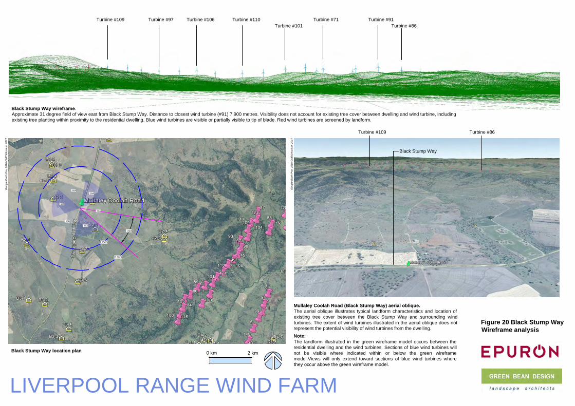
2.2km
3.3km
31°
31°
60°
60°
60°
60°
60°
60°
Black Stump Way wireframe.
Approximate 31 degree field of view east from Black Stump Way. Distance to closest wind turbine (#91) 7,900 metres. Visibility does not account for existing tree cover between dwelling and wind turbine, including
existing tree planting within proximity to the residential dwelling. Blue wind turbines are visible or partially visible to tip of blade. Red wind turbines are screened by landform.
Black Stump Way location plan
Figure 20 Black Stump Way
Wireframe analysis
LIVERPOOL RANGE WIND FARM
Turbine #110
Black Stump Way
Mullaley Coolah Road (Black Stump Way) aerial oblique.
The aerial oblique illustrates typical landform characteristics and location of
existing tree cover between the Black Stump Way and surrounding wind
turbines. The extent of wind turbines illustrated in the aerial oblique does not
represent the potential visibility of wind turbines from the dwelling.
Note:
The landform illustrated in the green wireframe model occurs between the
residential dwelling and the wind turbines. Sections of blue wind turbines will
not be visible where indicated within or below the green wireframe
model.Views will only extend toward sections of blue wind turbines where
they occur above the green wireframe model.
0 km 2 km
Turbine #101
Turbine #109 Turbine #86
Turbine #71 Turbine #91
Turbine #86
Turbine #106Turbine #109 Turbine #97
Go
og
le
E
arth
P
ro
, 2
01
6 C
NE
S/A
striu
m 2
01
7
Go
og
le
E
arth
P
ro
, 2
01
6 C
NE
S/A
striu
m 2
01
7

GREEN BEAN DESIGN l a n d s c a p e a r c h i t e c t s
Liverpool Range Wind Farm Landscape and Visual Impact Assessment – Addendum Report February 2017
47
Summary
Table 2 presents a summary of the additional visual assessment prepared for the residential dwellings included in the LVIA March 2014 and nominated in the NSW
Department of Planning and Environment submission.
Table 2
Dwelling
ID
Name Involved or
uninvolved
Closest wind
turbine
Number of 60o
sectors with wind turbines
LVIA March
2014 visual
impact
Additional visual
assessment
Comments and potential mitigation
C2‐3 Binnia Hills Uninvolved 3,265m 2 Medium Low to medium Existing vegetation provides some screening
toward proposed wind turbines from the
dwelling and garden area. Additional landscape
mitigation is unlikely to reduce the visual effect
to any significant degree.
C4‐1 Winooka Uninvolved 3,631m 1 Medium Medium Existing scattered tree planting provides some
degree of screening and filtering of views
toward proposed wind turbines from the
dwelling and garden area. Additional tree
planting to the east of the dwelling would have
potential to provide mitigation of more distant
views toward wind turbines located on a
ridgeline to the east of the dwelling. Additional

GREEN BEAN DESIGN l a n d s c a p e a r c h i t e c t s
Liverpool Range Wind Farm Landscape and Visual Impact Assessment – Addendum Report February 2017
48
Table 2
Dwelling
ID
Name Involved or
uninvolved
Closest wind
turbine
Number of 60o
sectors with wind turbines
LVIA March
2014 visual
impact
Additional visual
assessment
Comments and potential mitigation
tree planting would have potential to result in a
low to medium visual effect.
C4‐5 Gundare Uninvolved 3,500m 2 Medium Medium Additional tree planting to the north and east of
the dwelling would have potential to provide
mitigation of views toward wind turbines
located on ridgelines to the north east and east
of the dwelling. Additional tree planting will
have potential to result in a low to medium
visual effect.
C4‐8 Uninvolved 3,200m 2 Medium Medium to high Additional tree planting to the north and east of
the dwelling would have potential to provide
mitigation of views toward wind turbines
located on ridgelines to the north and east of the
dwelling. Additional tree planting will have
potential to result in a medium visual effect.

GREEN BEAN DESIGN l a n d s c a p e a r c h i t e c t s
Liverpool Range Wind Farm Landscape and Visual Impact Assessment – Addendum Report February 2017
49
Table 2
Dwelling
ID
Name Involved or
uninvolved
Closest wind
turbine
Number of 60o
sectors with wind turbines
LVIA March
2014 visual
impact
Additional visual
assessment
Comments and potential mitigation
C4‐9 Leeton Uninvolved 3,582m 2 Medium Medium Existing scattered tree planting and adjoining
farm building provide some degree of screening
and filtering of views toward proposed wind
turbines from the dwelling. Additional tree
planting to the east of the dwelling would have
potential to provide mitigation of more distant
views toward wind turbines located on a
ridgeline to the east of the dwelling. Additional
tree planting would have potential to result in a
low to medium visual effect.
C5‐6 Kurralah Uninvolved 3,561m 1 Medium Medium Existing scattered tree planting and adjoining
farm building provide some degree of screening
and filtering of views toward proposed wind
turbines from the dwelling. Additional tree
planting to the east of the dwelling would have
potential to provide mitigation of views toward
wind turbines located on ridgelines to the north

GREEN BEAN DESIGN l a n d s c a p e a r c h i t e c t s
Liverpool Range Wind Farm Landscape and Visual Impact Assessment – Addendum Report February 2017
50
Table 2
Dwelling
ID
Name Involved or
uninvolved
Closest wind
turbine
Number of 60o
sectors with wind turbines
LVIA March
2014 visual
impact
Additional visual
assessment
Comments and potential mitigation
and east of the dwelling. Additional tree planting
will have potential to result in a low to medium
visual effect.
C5‐9 Willania Uninvolved 3,229m 2 Medium Medium Existing scattered tree planting provides some
degree of screening and filtering of views
toward proposed wind turbines from the
dwelling. Some limited additional tree planting
to reinforce existing tree planting would have
potential to mitigate views to the north and
south east of the dwelling.
C6‐1 Sunnyside Involved ‐ ‐ ‐ ‐ ‐
C6‐3 Collie Blue Uninvolved 2,283m 2 Medium Medium Existing scattered tree planting provides some
degree of screening and filtering of views
toward proposed wind turbines from the
dwelling and garden area. Additional tree
planting to the north east and east of the

GREEN BEAN DESIGN l a n d s c a p e a r c h i t e c t s
Liverpool Range Wind Farm Landscape and Visual Impact Assessment – Addendum Report February 2017
51
Table 2
Dwelling
ID
Name Involved or
uninvolved
Closest wind
turbine
Number of 60o
sectors with wind turbines
LVIA March
2014 visual
impact
Additional visual
assessment
Comments and potential mitigation
dwelling would have potential to provide
mitigation of more distant views toward wind
turbines located on a ridgeline to the east of the
dwelling. Additional tree planting would have
potential to result in a low to medium visual
effect.
C6‐4 Brooksby Involved ‐ ‐ ‐ ‐ ‐
C7‐1 Wilandra Involved ‐ ‐ ‐ ‐ ‐
D4‐9 Gynawah Involved 2,200m Medium to high Medium to high Involved landowner, no proposed mitigation to
reduce potential visual impact
D7‐2 Involved 4,280m 2 Medium Medium ‐
D7‐3 Tallue Uninvolved ‐ ‐ ‐ ‐ No proposed mitigation to reduce potential
visual impact

GREEN BEAN DESIGN l a n d s c a p e a r c h i t e c t s
Liverpool Range Wind Farm Landscape and Visual Impact Assessment – Addendum Report February 2017
52
Table 2
Dwelling
ID
Name Involved or
uninvolved
Closest wind
turbine
Number of 60o
sectors with wind turbines
LVIA March
2014 visual
impact
Additional visual
assessment
Comments and potential mitigation
D7‐4 Cooinda Uninvolved 2,926m 1 Medium Medium Existing scattered tree planting provides some
degree of screening and filtering of views
toward proposed wind turbines from the
dwelling and garden area. Additional tree
planting to the east of the dwelling would have
potential to provide mitigation of more distant
views toward wind turbines located on a
ridgeline to the north east and east of the
dwelling. Additional tree planting would have
potential to result in a low to medium visual
effect.
E9‐4 Rangeview Uninvolved 4,000m 1 Medium Low to medium Landscape mitigation is considered unlikely to
provide any additional or significant potential
screening for this dwelling.
F8‐1 Tangaratta Involved ‐ ‐ ‐ ‐ ‐

GREEN BEAN DESIGN l a n d s c a p e a r c h i t e c t s
Liverpool Range Wind Farm Landscape and Visual Impact Assessment – Addendum Report February 2017
53
Table 2
Dwelling
ID
Name Involved or
uninvolved
Closest wind
turbine
Number of 60o
sectors with wind turbines
LVIA March
2014 visual
impact
Additional visual
assessment
Comments and potential mitigation
F9‐1 Culbara Uninvolved 2,337m 1 Medium Low to medium Landscape mitigation is considered unlikely to
provide any additional or significant potential
screening for this dwelling.
G6‐2 Glenwood Uninvolved 1,974m 1 Low to medium Low to medium Landscape mitigation is considered unlikely to
provide any additional or significant potential
screening for this dwelling.
G6‐3 Ellaroy Uninvolved 2,249m 1 Low to medium Low to medium Landscape mitigation is considered unlikely to
provide any additional or significant potential
screening for this dwelling.
H6‐3 Uninvolved ‐ ‐ ‐ ‐ ‐
H7‐1 St Antoine Uninvolved 1,795m 1 Low Low Landscape mitigation is considered unlikely to
provide any additional or significant potential
screening for this dwelling.

GREEN BEAN DESIGN l a n d s c a p e a r c h i t e c t s
Liverpool Range Wind Farm Landscape and Visual Impact Assessment – Addendum Report February 2017
54
Amended wind turbine dimensions
The LVIA March 2014 included photomontages which illustrated the proposed wind turbines at a 157‐metre tip
height. Subsequent to the preparation of the LVIA, the proposed wind turbine design parameters were amended
to include a wind turbine with a 165‐metre tip height. The 165‐metre tip height have been illustrated in the wind
turbines presented in the wireframe models included in this Addendum Report.
The LVIA March 2014, and the amended wind turbine are compared and illustrated in Figure 21 and described
in Table 3.
Table 3: LVIA March 2014 and amended wind turbine dimensions
Hub height Rotor diameter Tip height
LVIA March 2014 wind turbine 101 112 m 157 m
Amended wind turbine 101 130 m 165 m
Difference 0 +18 m 9 m
Percentage difference 0% +14% +5%
Given the relatively small increase in proposed wind turbine tip height (around 5%), the increase in height is not
considered to be of a magnitude that would significantly increase visual effects of the wind turbines presented
in the LVIA March 2014 photomontages.
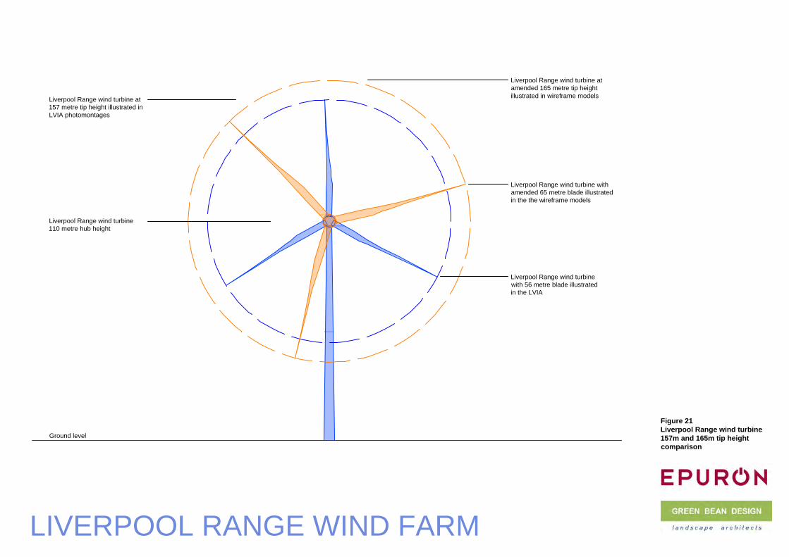
Figure 21
Liverpool Range wind turbine
157m and 165m tip height
comparison
LIVERPOOL RANGE WIND FARM
Liverpool Range wind turbine at
157 metre tip height illustrated in
LVIA photomontages
Ground level
Liverpool Range wind turbine
110 metre hub height
Liverpool Range wind turbine at
amended 165 metre tip height
illustrated in wireframe models
Liverpool Range wind turbine
with 56 metre blade illustrated
in the LVIA
Liverpool Range wind turbine with
amended 65 metre blade illustrated
in the the wireframe models
Recommended