


Appendix 1 Figures

0
5
10
15
20
25
30
35
40
45
50
55
60
65
70
-20 0 20 40 60 80 100 120 140 160 180 200 220
0
5
10
15
20
25
30
35
40
45
50
55
60
65
70
Horizontal Scale (feet)
Vertical Exaggeration: 2x
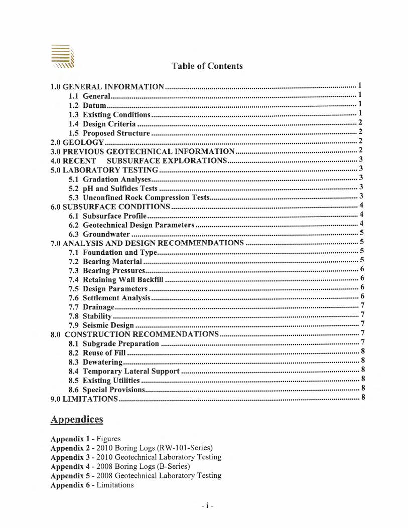
A A'
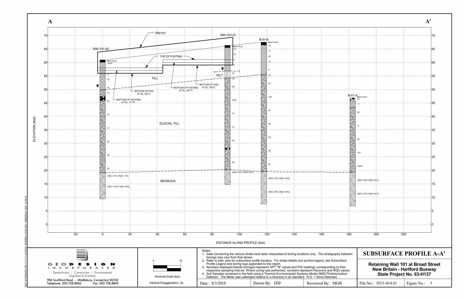
Notes:1. Data concerning the various strata have been interpreted at boring locations only. The stratigraphy between
borings may vary from that shown.2. Refer to plan view for subsurface profile location. For strata details and symbol legend, see Subsurface
Profile Legend and boring logs appended to this report.3. Numbers displayed beside boring(s) represent SPT "N" values and PID readings corresponding to their
respective sampling interval. Where coring was performed, numbers represent Recovery and RQD values.4. Soil Samples screened in the field using a Thermal Environmental Systems Model 580S Photoionization
Detector. The Meter was calibrated relative to a benzene in air standard. N.D. = None Detected.
ELE
VA
TIO
N (
feet
)
DISTANCE ALONG PROFILE (feet)
SUBSURFACE PROFILE A-A'
File No.: 0331-014.01 Figure No.: 3Reviewed By: MGBDrawn By: DSF
Geotechnical | Construction | EnvironmentalEngineers & Scientists
984 Southford Road - Middlebury, Connecticut 06762Telephone: 203.758.8836 Fax: 203.758.8842
GE
O S
TA
ND
AR
D P
ID 1
1 X
17
(2/2
5/0
4)
BO
RIN
G L
OG
S.G
PJ
FB
NW
NL0
1.G
DT
5/1
9/10
200
20
17
40
71
59
119
100/5"
B-01-4Blow Count
19
17
20
13
9
27
93
145
64
66
58
90
87
B-01-6Blow Count
25
36
58
87/6"
74
31
45
48
100/2"
76
32
74
93
47
21
20
45
89
Date: 8/3/2010
Retaining Wall 101 at Broad StreetNew Britain - Hartford Busway
State Project No. 63-H137
RW-101-02
7
Blow Count
8
5
32
53Blow Count
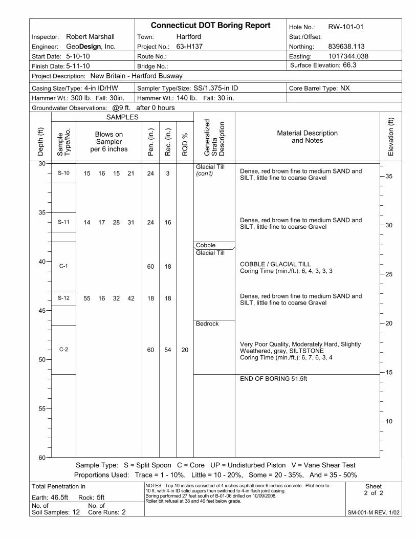
RW-101-01
[REC= 98%; RQD= 65%]
[REC= 97%; RQD= 83%]
[REC= 97%; RQD= 63%]
[REC= 95%; RQD= 82%]
[REC= 90%; RQD= 20%]
[REC= 81%; RQD= 17%]
[REC= 100%; RQD= 58%]
? ?
GLACIAL TILL
BEDROCK
SILT
TOP OF FOOTING
RW101
BOTTOM OF FOOTINGAT EL. 60 FT.
BOTTOM OF PADAT EL. 59 FT.
FILL
BOTTOM OF PADAT EL. 56 FT.
BOTTOM OF FOOTINGAT EL. 57 FT.

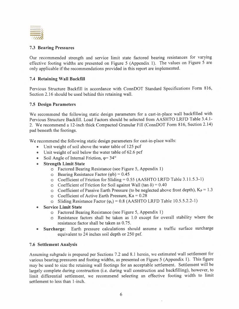
Factored Bearing Resistance vs. Effective Footing Width
0
2
4
6
8
10
12
14
16
0.0 2.0 4.0 6.0 8.0 10.0 12.0
Effective Footing Width (ft)
Fac
tore
d B
eari
ng
Res
ista
nce
(ks
f)
2-in Settlement (service Limit)1-in Settlement (service Limit)1/2-in Settlement (service Limit)1/4-in Settlement (service Limit)Strength Limit State
Busway North - Retaining Wall 101GeoDesign File No. 0331-014.01
Figure 5 - Factored Bearing Resistances
Appendix 2 2010 Boring Logs (RW-101-Series)

PavementFill
Silt
Glacial Till
14 24 29 20
13 15 17 14
4 3 2 2
4 4 4 5
7 11 14 20
10 16 20 24
45 `56 58 65
53 87/6"
24 26 48 59
24
24
24
24
24
24
24
12
24
12
15
16
18
24
22
15
9
0
S-1
S-2
S-3
S-4
S-5
S-6
S-7
S-8
S-9
Very dense,Top 6": red brown fine to medium SAND, littlefine Gravel, little SiltBottom 6": gray brown fine to coarse GRAVEL,little fine to coarse Sand, trace SiltDense, black ASH and CINDERS, trace fine tomedium Sand, trace Silt
Loose, black ASH and CINDERS, trace fineSand
Loose, red brown SILT and fine to coarse SAND,little fine to coarse Gravel, trace Brick fragments
Medium dense, red brown SILT, little fine Sand
Dense, red brown SILT, some fine to coarseSand, little fine Gravel
Very dense, red brown SILT and fine to coarseSAND, trace fine Gravel
Very dense, red brown fine to coarse SAND andSILT, little fine to coarse Gravel
Very dense, no recovery
Bridge No.:
Route No.:
Fall: 30 in.Hammer Wt.: 300 lb. Hammer Wt.: 140 lb.
No. ofCore Runs: 2
RQ
D %
Casing Size/Type: 4-in ID/HW
Total Penetration in
Hole No.: RW-101-01
Sheet1 of 2
No. ofSoil Samples: 12
Fall: 30in.
Sampler Type/Size: SS/1.375-in ID
Groundwater Observations: @9 ft. after 0 hours
Gen
eral
ized
Str
ata
Des
crip
tion
Dep
th (
ft)
0
5
10
15
20
25
30
SAMPLES
Inspector: Robert Marshall
Finish Date: 5-11-10
Connecticut DOT Boring Report
Blows onSampler
per 6 inches
Core Barrel Type: NX
Rock: 5ft
Sample Type: S = Split Spoon C = Core UP = Undisturbed Piston V = Vane Shear Test
Proportions Used: Trace = 1 - 10%, Little = 10 - 20%, Some = 20 - 35%, And = 35 - 50%
Surface Elevation: 66.3
SM-001-M REV. 1/02
Pen
. (in
.)
Rec
. (in
.)
Ele
vatio
n (f
t)
65
60
55
50
45
40
Earth: 46.5ft
Stat./Offset:
Sam
ple
Typ
e/N
o.
Project No.: 63-H137
Town: Hartford
NOTES: Top 10 inches consisted of 4 inches asphalt over 6 inches concrete. Pilot hole to10 ft. with 4-in ID solid augers then switched to 4-in flush joint casing.Boring performed 27 feet south of B-01-06 drilled on 10/09/2008.Roller bit refusal at 38 and 46 feet below grade.
Material Descriptionand Notes
Project Description: New Britain - Hartford Busway
Northing: 839638.113
Easting: 1017344.038
Engineer: GeoDesign, Inc.
Start Date: 5-10-10
20
Glacial Till(con't)
CobbleGlacial Till
Bedrock
15 16 15 21
14 17 28 31
55 16 32 42
24
24
60
18
60
3
16
18
18
54
S-10
S-11
C-1
S-12
C-2
Dense, red brown fine to medium SAND andSILT, little fine to coarse Gravel
Dense, red brown fine to medium SAND andSILT, little fine to coarse Gravel
COBBLE / GLACIAL TILLCoring Time (min./ft.): 6, 4, 3, 3, 3
Dense, red brown fine to medium SAND andSILT, little fine to coarse Gravel
Very Poor Quality, Moderately Hard, SlightlyWeathered, gray, SILTSTONECoring Time (min./ft.): 6, 7, 6, 3, 4
END OF BORING 51.5ft
Bridge No.:
Route No.:
Fall: 30 in.Hammer Wt.: 300 lb. Hammer Wt.: 140 lb.
No. ofCore Runs: 2
RQ
D %
Casing Size/Type: 4-in ID/HW
Total Penetration in
Hole No.: RW-101-01
Sheet2 of 2
No. ofSoil Samples: 12
Fall: 30in.
Sampler Type/Size: SS/1.375-in ID
Groundwater Observations: @9 ft. after 0 hours
Gen
eral
ized
Str
ata
Des
crip
tion
Dep
th (
ft)
30
35
40
45
50
55
60
SAMPLES
Inspector: Robert Marshall
Finish Date: 5-11-10
Connecticut DOT Boring Report
Blows onSampler
per 6 inches
Core Barrel Type: NX
Rock: 5ft
Sample Type: S = Split Spoon C = Core UP = Undisturbed Piston V = Vane Shear Test
Proportions Used: Trace = 1 - 10%, Little = 10 - 20%, Some = 20 - 35%, And = 35 - 50%
Surface Elevation: 66.3
SM-001-M REV. 1/02
Pen
. (in
.)
Rec
. (in
.)
Ele
vatio
n (f
t)
35
30
25
20
15
10
Earth: 46.5ft
Stat./Offset:
Sam
ple
Typ
e/N
o.
Project No.: 63-H137
Town: Hartford
NOTES: Top 10 inches consisted of 4 inches asphalt over 6 inches concrete. Pilot hole to10 ft. with 4-in ID solid augers then switched to 4-in flush joint casing.Boring performed 27 feet south of B-01-06 drilled on 10/09/2008.Roller bit refusal at 38 and 46 feet below grade.
Material Descriptionand Notes
Project Description: New Britain - Hartford Busway
Northing: 839638.113
Easting: 1017344.038
Engineer: GeoDesign, Inc.
Start Date: 5-10-10

PavementFill
Glacial Till
Boulder
Glacial Till
31 100/2"
1 2 5 11
16 31 45
9 9 23 36
24 29 45 30/1"
16 39 54 53
54 32 15 17
9 9 12 25
8
24
18
24
19
24
24
24
2
20
18
22
18
18
8
10
S-1
S-2
S-3
S-4
S-5
S-6
S-7
S-8
Very dense, gray fine to medium SAND, little Silt,trace Asphalt fragments
Loose, dark gray SILT, little fine Sand, traceBrick fragments, trace OrganicsVery dense, red brown SILT, some fine to coarseSand, some fine to coarse Gravel, trace Brickfragments
Dense, red brown SILT, trace fine to mediumSand
Very dense, red brown SILT, some fine to coarseSAND, little fine to coarse Gravel
Very dense, red brown fine to coarse SAND,some Silt, little fine Gravel
Dense, red brown fine to coarse SAND, someSilt, some fine to coarse Gravel
Medium dense, red brown fine to coarse SANDand CLAYEY SILT, some fine Gravel
Bridge No.:
Route No.:
Fall: 30 in.Hammer Wt.: 300 lb. Hammer Wt.: 140 lb.
No. ofCore Runs: 2
RQ
D %
Casing Size/Type: 4-in ID/HW
Total Penetration in
Hole No.: RW-101-02
Sheet1 of 2
No. ofSoil Samples: 11
Fall: 30in.
Sampler Type/Size: SS/1.375-in ID
Groundwater Observations: @10 ft. after 0 hours
Gen
eral
ized
Str
ata
Des
crip
tion
Dep
th (
ft)
0
5
10
15
20
25
30
SAMPLES
Inspector: Robert Marshall
Finish Date: 5-12-10
Connecticut DOT Boring Report
Blows onSampler
per 6 inches
Core Barrel Type: NX
Rock: 9ft
Sample Type: S = Split Spoon C = Core UP = Undisturbed Piston V = Vane Shear Test
Proportions Used: Trace = 1 - 10%, Little = 10 - 20%, Some = 20 - 35%, And = 35 - 50%
Surface Elevation: 60.9
SM-001-M REV. 1/02
Pen
. (in
.)
Rec
. (in
.)
Ele
vatio
n (f
t)
60
55
50
45
40
35
Earth: 42.5ft
Stat./Offset:
Sam
ple
Typ
e/N
o.
Project No.: 63-H137
Town: Hartford
NOTES: Top 10 inches consisted of 4 inches asphalt over 6 inches concrete. Wet sampleat 10 feet below grade.Pilot hole to 10 feet with 4-in OD solid augers then switched to 4-in casing.Roller bit through boulder 13.6 to 15 feet below grade. Telescoped 3-in casing below 4-incasing refusal at 13.5 feet.
Material Descriptionand Notes
Project Description: New Britain - Hartford Busway
Northing: 839547.924
Easting: 1017330.076
Engineer: GeoDesign, Inc.
Start Date: 5-11-10
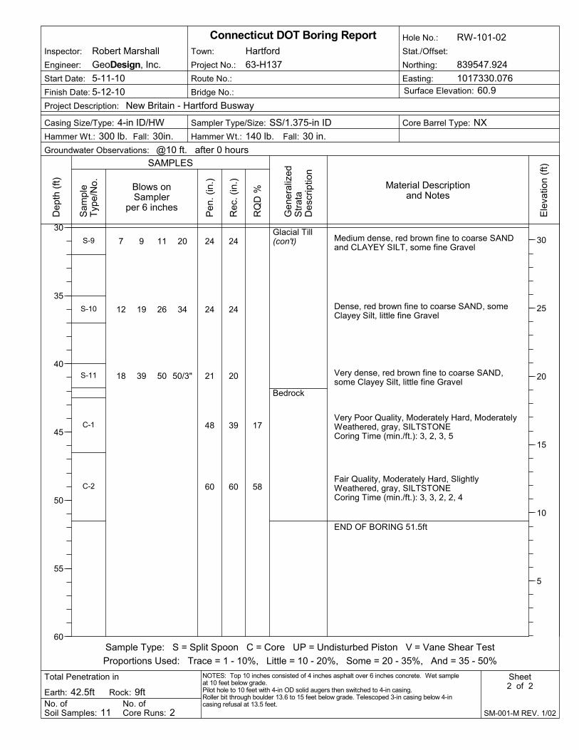
17
58
Glacial Till(con't)
Bedrock
7 9 11 20
12 19 26 34
18 39 50 50/3"
24
24
21
48
60
24
24
20
39
60
S-9
S-10
S-11
C-1
C-2
Medium dense, red brown fine to coarse SANDand CLAYEY SILT, some fine Gravel
Dense, red brown fine to coarse SAND, someClayey Silt, little fine Gravel
Very dense, red brown fine to coarse SAND,some Clayey Silt, little fine Gravel
Very Poor Quality, Moderately Hard, ModeratelyWeathered, gray, SILTSTONECoring Time (min./ft.): 3, 2, 3, 5
Fair Quality, Moderately Hard, SlightlyWeathered, gray, SILTSTONECoring Time (min./ft.): 3, 3, 2, 2, 4
END OF BORING 51.5ft
Bridge No.:
Route No.:
Fall: 30 in.Hammer Wt.: 300 lb. Hammer Wt.: 140 lb.
No. ofCore Runs: 2
RQ
D %
Casing Size/Type: 4-in ID/HW
Total Penetration in
Hole No.: RW-101-02
Sheet2 of 2
No. ofSoil Samples: 11
Fall: 30in.
Sampler Type/Size: SS/1.375-in ID
Groundwater Observations: @10 ft. after 0 hours
Gen
eral
ized
Str
ata
Des
crip
tion
Dep
th (
ft)
30
35
40
45
50
55
60
SAMPLES
Inspector: Robert Marshall
Finish Date: 5-12-10
Connecticut DOT Boring Report
Blows onSampler
per 6 inches
Core Barrel Type: NX
Rock: 9ft
Sample Type: S = Split Spoon C = Core UP = Undisturbed Piston V = Vane Shear Test
Proportions Used: Trace = 1 - 10%, Little = 10 - 20%, Some = 20 - 35%, And = 35 - 50%
Surface Elevation: 60.9
SM-001-M REV. 1/02
Pen
. (in
.)
Rec
. (in
.)
Ele
vatio
n (f
t)
30
25
20
15
10
5
Earth: 42.5ft
Stat./Offset:
Sam
ple
Typ
e/N
o.
Project No.: 63-H137
Town: Hartford
NOTES: Top 10 inches consisted of 4 inches asphalt over 6 inches concrete. Wet sampleat 10 feet below grade.Pilot hole to 10 feet with 4-in OD solid augers then switched to 4-in casing.Roller bit through boulder 13.6 to 15 feet below grade. Telescoped 3-in casing below 4-incasing refusal at 13.5 feet.
Material Descriptionand Notes
Project Description: New Britain - Hartford Busway
Northing: 839547.924
Easting: 1017330.076
Engineer: GeoDesign, Inc.
Start Date: 5-11-10

Appendix 3 2010 Geotechnical Laboratory Testing

GRAVEL SAND
COBBLES SILT OR CLAYCOARSE FINE COARSE MEDIUM FINE
GRADATION TESTBusway North: RW-101 BURMISTER SOIL CLASSIFICATION SYSTEM
TEST NO. MATERIAL SOURCE DESCRIPTION
BORING NO. RW-101-01
SAMPLE NO. S-4
DEPTH 7-9 ft 1 of 5 Jar Sample SILT and fineto coarse SAND, little fine to coarse Gravel
TECH. RJM
REVIEWER MGB
DATE 05/24/10
FILE NO. 331-14.1
U.S. STANDARD SIEVE SIZE
0%
10%
20%
30%
40%
50%
60%
70%
80%
90%
100%
0.0010.010.1110100
GRAIN SIZE IN MILLIMETERS
PE
RC
EN
T F
INE
R B
Y W
EIG
HT
1 1/2" No. 200No. 100No.60No.40 3" No. 10No. 41/2" 3/4" 1" 2"

GRAVEL SAND
COBBLES SILT OR CLAYCOARSE FINE COARSE MEDIUM FINE
GRADATION TESTBusway North: RW-101 BURMISTER SOIL CLASSIFICATION SYSTEM
TEST NO. MATERIAL SOURCE DESCRIPTION
BORING NO. RW-101-01
SAMPLE NO. S-6
DEPTH 12-14 ft 2 of 5 Jar Sample SILT, some fine to coarse Sand, little fine Gravel
TECH. RJM
REVIEWER MGB
DATE 05/24/10
FILE NO. 331-14.1
U.S. STANDARD SIEVE SIZE
0%
10%
20%
30%
40%
50%
60%
70%
80%
90%
100%
0.0010.010.1110100
GRAIN SIZE IN MILLIMETERS
PE
RC
EN
T F
INE
R B
Y W
EIG
HT
1 1/2" No. 200No. 100No.60No.40 3" No. 10No. 41/2" 3/4" 1" 2"

GRAVEL SAND
COBBLES SILT OR CLAYCOARSE FINE COARSE MEDIUM FINE
GRADATION TESTBusway North: RW-101 BURMISTER SOIL CLASSIFICATION SYSTEM
TEST NO. MATERIAL SOURCE DESCRIPTION
BORING NO. RW-101-02
SAMPLE NO. S-3
DEPTH 7-8.5 ft 3 of 5 Jar Sample SILT, some fine to coarse Gravel, some fine to coarse Sand
TECH. RJM
REVIEWER MGB
DATE 05/24/10
FILE NO. 331-14.1
U.S. STANDARD SIEVE SIZE
0%
10%
20%
30%
40%
50%
60%
70%
80%
90%
100%
0.0010.010.1110100
GRAIN SIZE IN MILLIMETERS
PE
RC
EN
T F
INE
R B
Y W
EIG
HT
1 1/2" No. 200No. 100No.60No.40 3" No. 10No. 41/2" 3/4" 1" 2"
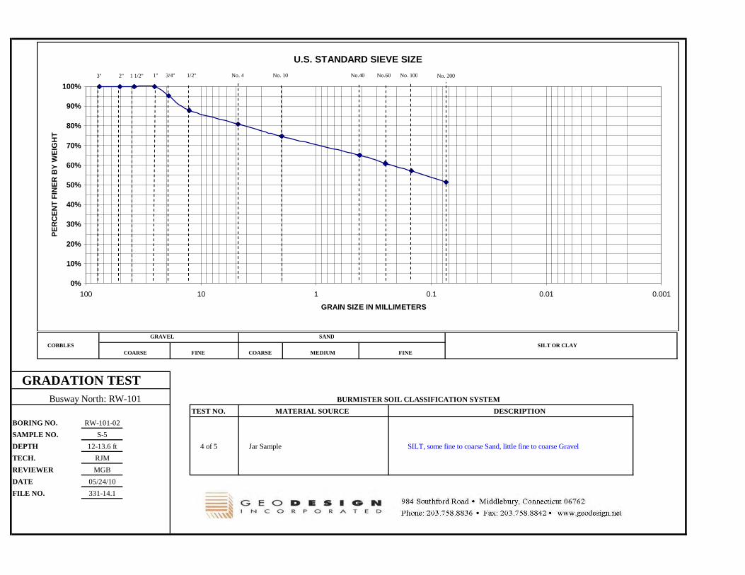
GRAVEL SAND
COBBLES SILT OR CLAYCOARSE FINE COARSE MEDIUM FINE
GRADATION TESTBusway North: RW-101 BURMISTER SOIL CLASSIFICATION SYSTEM
TEST NO. MATERIAL SOURCE DESCRIPTION
BORING NO. RW-101-02
SAMPLE NO. S-5
DEPTH 12-13.6 ft 4 of 5 Jar Sample SILT, some fine to coarse Sand, little fine to coarse Gravel
TECH. RJM
REVIEWER MGB
DATE 05/24/10
FILE NO. 331-14.1
U.S. STANDARD SIEVE SIZE
0%
10%
20%
30%
40%
50%
60%
70%
80%
90%
100%
0.0010.010.1110100
GRAIN SIZE IN MILLIMETERS
PE
RC
EN
T F
INE
R B
Y W
EIG
HT
1 1/2" No. 200No. 100No.60No.40 3" No. 10No. 41/2" 3/4" 1" 2"
GRAVEL SAND
COBBLES SILT OR CLAYCOARSE FINE COARSE MEDIUM FINE
GRADATION TESTBusway North: RW-101 BURMISTER SOIL CLASSIFICATION SYSTEM
TEST NO. MATERIAL SOURCE DESCRIPTION
BORING NO. RW-101-02
SAMPLE NO. S-7
DEPTH 20-22 ft 5 of 5 Jar Sample fine to coarse SAND, some Silt, some fine to coarse Gravel
TECH. RJM
REVIEWER MGB
DATE 05/24/10
FILE NO. 331-14.1
U.S. STANDARD SIEVE SIZE
0%
10%
20%
30%
40%
50%
60%
70%
80%
90%
100%
0.0010.010.1110100
GRAIN SIZE IN MILLIMETERS
PE
RC
EN
T F
INE
R B
Y W
EIG
HT
1 1/2" No. 200No. 100No.60No.40 3" No. 10No. 41/2" 3/4" 1" 2"

Appendix 4 2008 Boring Logs
(B-Series)

CrushedStoneFill
Glacial Till
Top 8": Medium dense, gray fine to coarseGRAVELBottom 7": Medium dense, gray fine to coarseSAND and SILT, (moist)Top 12": Medium dense, brown fine to coarseSAND, trace Silt, (wet)Bottom 7": Medium dense, red brown Clayey SILT,some fine to coarse Sand, (wet)
Dense, red brown Clayey SILT, some fine tocoarse Sand, little fine to coarse Gravel, (wet)
Very dense, red brown Clayey SILT, some fine tocoarse Sand, little fine to coarse Gravel, (wet)
Very dense, red brown Clayey SILT, some fine tocoarse Sand, little fine to coarse Gravel, (wet)
Very dense, red brown Clayey SILT, some fine tocoarse Sand, little fine to coarse Gravel, (wet)
6 11 9 10
3 9 8 8
13 15 25 35
21 33 38 44
16 24 35 38
14 19 100
24
24
24
24
24
18
15
19
18
20
14
10
S-1
S-2
S-3
S-4
S-5
S-6
No. ofCore Runs: 2
RQ
D %
Start Date: 9-25-08
Casing Size/Type: 4"/HW
Total Penetration in
Hole No.: B-01-4
Sheet1 of 2
No. ofSoil Samples: 7
Fall: 24"
Sampler Type/Size: SS / 1 3/8"
Groundwater Observations: @3' during drilling
Gen
eral
ized
Str
ata
Des
crip
tion
Dep
th (
ft)
0
5
10
15
20
25
SAMPLES
Connecticut DOT Boring Report
Material Descriptionand Notes
Blows onSampler
per 6 inches
Core Barrel Type: NQ
Engineer: GeoDesign, Inc.
Rock: 10ft
Sample Type: S = Split Spoon C = Core UP = Undisturbed Piston V = Vane Shear Test
Proportions Used: Trace = 1 - 10%, Little = 10 - 20%, Some = 20 - 35%, And = 35 - 50%
Easting: 1017360.9Surface Elevation: 46.8
SM-001-M REV. 1/02
Pen
. (in
.)
Rec
. (in
.)
Ele
vatio
n (f
t)
45
40
35
30
25
Earth: 30ft
Stat./Offset:
Project Description: New Britain / Hartford Busway -
Sam
ple
Typ
e/N
o.
Town: Hartford
Project No.: 63-H137 / 0331-014.0
Finish Date: 9-25-08 Bridge No.:
Route No.:
Inspector: Garry Jacobson
NOTES: Used solid stem augers to 10'. Drove casing to 20', then open hole.
Fall: 30"Hammer Wt.: 300 lbs. Hammer Wt.: 140 lbs.
Northing: 839728.0

65
83
Glacial Till(con't)
Bedrock
Very dense, red brown Clayey SILT, some fine tocoarse Sand, little fine to coarse Gravel, (wet)
Fair, Moderately Hard, Slightly Weathered, gray,aphanitic SILTSTONE. Bedding is massive.Primary joints horizontal, 2" to 18" spacing.Several high angle secondary joints are rough,carved.Coring time (min./ ft.): 7, 7, 7, 8, 8
Fair, Moderately Hard, Slightly Weathered, gray,aphanitic SILTSTONE. Bedding is massive.Primary joint spacing is 2" to 24" and nosecondary joints.Coring time (min./ ft.): 8, 8, 8, 9, 9
END OF BORING 40ft
100/5" 5
60
60
4
59
58
S-7
C-1
C-2
No. ofCore Runs: 2
RQ
D %
Start Date: 9-25-08
Casing Size/Type: 4"/HW
Total Penetration in
Hole No.: B-01-4
Sheet2 of 2
No. ofSoil Samples: 7
Fall: 24"
Sampler Type/Size: SS / 1 3/8"
Groundwater Observations: @3' during drilling
Gen
eral
ized
Str
ata
Des
crip
tion
Dep
th (
ft)
25
30
35
40
45
50
SAMPLES
Connecticut DOT Boring Report
Material Descriptionand Notes
Blows onSampler
per 6 inches
Core Barrel Type: NQ
Engineer: GeoDesign, Inc.
Rock: 10ft
Sample Type: S = Split Spoon C = Core UP = Undisturbed Piston V = Vane Shear Test
Proportions Used: Trace = 1 - 10%, Little = 10 - 20%, Some = 20 - 35%, And = 35 - 50%
Easting: 1017360.9Surface Elevation: 46.8
SM-001-M REV. 1/02
Pen
. (in
.)
Rec
. (in
.)
Ele
vatio
n (f
t)
20
15
10
5
0
Earth: 30ft
Stat./Offset:
Project Description: New Britain / Hartford Busway -
Sam
ple
Typ
e/N
o.
Town: Hartford
Project No.: 63-H137 / 0331-014.0
Finish Date: 9-25-08 Bridge No.:
Route No.:
Inspector: Garry Jacobson
NOTES: Used solid stem augers to 10'. Drove casing to 20', then open hole.
Fall: 30"Hammer Wt.: 300 lbs. Hammer Wt.: 140 lbs.
Northing: 839728.0

Pavement
Fill
Glacial Till
6" of ASPHALT over 6" GRAVEL Base
Medium dense, brown to red brown fine tomedium SAND, little fine to coarse Gravel, little Silt
Medium dense, brown fine to medium SAND, littlefine to coarse Gravel, little Silt, little Ash/ Cinders
Medium dense, red brown fine to medium SAND,little fine to coarse Gravel, little Silt
Medium dense, no recovery
Loose, red brown SILT, little fine to medium Sand,little fine Gravel, (wet)
Medium dense, red brown fine to medium SAND,some Silt, little fine Gravel
Very dense, red brown fine to medium SAND,some Silt, little fine Gravel
Very dense, red brown fine to medium SAND,some fine to coarse Gravel, some Silt
10 10 9 8
7 8 9 11
15 11 9 8
8 7 6 7
9 5 4 7
9 11 16 17
21 44 49 57
47 60 85
24
24
24
24
24
24
24
18
12
8
12
0
12
16
13
16
S-1
S-2
S-3
S-4
S-5
S-6
S-7
S-8
No. ofCore Runs: 2
RQ
D %
Start Date: 10-9-08
Casing Size/Type: 3"/NW
Total Penetration in
Hole No.: B-01-6
Sheet1 of 3
No. ofSoil Samples: 13
Fall: 24"
Sampler Type/Size: SS / 1 3/8"
Groundwater Observations: @10' after 0 hrs.
Gen
eral
ized
Str
ata
Des
crip
tion
Dep
th (
ft)
0
5
10
15
20
25
SAMPLES
Connecticut DOT Boring Report
Material Descriptionand Notes
Blows onSampler
per 6 inches
Core Barrel Type: NQ
Engineer: GeoDesign, Inc.
Rock: 10ft
Sample Type: S = Split Spoon C = Core UP = Undisturbed Piston V = Vane Shear Test
Proportions Used: Trace = 1 - 10%, Little = 10 - 20%, Some = 20 - 35%, And = 35 - 50%
Easting: 1017350.6Surface Elevation: 67.5
SM-001-M REV. 1/02
Pen
. (in
.)
Rec
. (in
.)
Ele
vatio
n (f
t)
65
60
55
50
45
Earth: 50ft
Stat./Offset:
Project Description: New Britain / Hartford Busway -
Sam
ple
Typ
e/N
o.
Town: Hartford
Project No.: 63-H137 / 0331-014.0
Finish Date: 10-9-08 Bridge No.:
Route No.:
Inspector: Robert Marshall
NOTES: Pilot hole to 5' with 4" OD SSA. Wet sample at 10'. Open hole below 30'.
Fall: 30"Hammer Wt.: 300 lbs. Hammer Wt.: 140 lbs.
Northing: 839663.9

Glacial Till(con't)
Bedrock
Very dense, red brown fine to medium SAND,some fine to coarse Gravel, some Silt
Very dense, red brown fine to medium SAND,some fine to coarse Gravel, some Silt
Very dense, red brown fine to medium SAND,some Silt, little fine to coarse Gravel
Very dense, red brown fine to medium SAND,some Silt, trace fine Gravel
Very dense, red brown fine to medium SAND,some Silt, trace fine Gravel
20 28 36 45
17 31 35 80
16 26 32 49
49 90
18 27 60 59
24
24
24
12
24
12
12
18
8
16
S-9
S-10
S-11
S-12
S-13
No. ofCore Runs: 2
RQ
D %
Start Date: 10-9-08
Casing Size/Type: 3"/NW
Total Penetration in
Hole No.: B-01-6
Sheet2 of 3
No. ofSoil Samples: 13
Fall: 24"
Sampler Type/Size: SS / 1 3/8"
Groundwater Observations: @10' after 0 hrs.
Gen
eral
ized
Str
ata
Des
crip
tion
Dep
th (
ft)
25
30
35
40
45
50
SAMPLES
Connecticut DOT Boring Report
Material Descriptionand Notes
Blows onSampler
per 6 inches
Core Barrel Type: NQ
Engineer: GeoDesign, Inc.
Rock: 10ft
Sample Type: S = Split Spoon C = Core UP = Undisturbed Piston V = Vane Shear Test
Proportions Used: Trace = 1 - 10%, Little = 10 - 20%, Some = 20 - 35%, And = 35 - 50%
Easting: 1017350.6Surface Elevation: 67.5
SM-001-M REV. 1/02
Pen
. (in
.)
Rec
. (in
.)
Ele
vatio
n (f
t)
40
35
30
25
20
Earth: 50ft
Stat./Offset:
Project Description: New Britain / Hartford Busway -
Sam
ple
Typ
e/N
o.
Town: Hartford
Project No.: 63-H137 / 0331-014.0
Finish Date: 10-9-08 Bridge No.:
Route No.:
Inspector: Robert Marshall
NOTES: Pilot hole to 5' with 4" OD SSA. Wet sample at 10'. Open hole below 30'.
Fall: 30"Hammer Wt.: 300 lbs. Hammer Wt.: 140 lbs.
Northing: 839663.9

63
82
Bedrock(con't)
Fair, Moderately Hard, Fresh, gray, SILTSTONECoring time (min./ft.): 6, 6, 6, 6, 6
Good, Moderately Hard, Fresh, gray, SILTSTONECoring time (min./ft.): 6, 5, 6, 5, 5
END OF BORING 60ft
60
60
58
57
C-1
C-2
No. ofCore Runs: 2
RQ
D %
Start Date: 10-9-08
Casing Size/Type: 3"/NW
Total Penetration in
Hole No.: B-01-6
Sheet3 of 3
No. ofSoil Samples: 13
Fall: 24"
Sampler Type/Size: SS / 1 3/8"
Groundwater Observations: @10' after 0 hrs.
Gen
eral
ized
Str
ata
Des
crip
tion
Dep
th (
ft)
50
55
60
65
70
75
SAMPLES
Connecticut DOT Boring Report
Material Descriptionand Notes
Blows onSampler
per 6 inches
Core Barrel Type: NQ
Engineer: GeoDesign, Inc.
Rock: 10ft
Sample Type: S = Split Spoon C = Core UP = Undisturbed Piston V = Vane Shear Test
Proportions Used: Trace = 1 - 10%, Little = 10 - 20%, Some = 20 - 35%, And = 35 - 50%
Easting: 1017350.6Surface Elevation: 67.5
SM-001-M REV. 1/02
Pen
. (in
.)
Rec
. (in
.)
Ele
vatio
n (f
t)
15
10
5
0
-5
Earth: 50ft
Stat./Offset:
Project Description: New Britain / Hartford Busway -
Sam
ple
Typ
e/N
o.
Town: Hartford
Project No.: 63-H137 / 0331-014.0
Finish Date: 10-9-08 Bridge No.:
Route No.:
Inspector: Robert Marshall
NOTES: Pilot hole to 5' with 4" OD SSA. Wet sample at 10'. Open hole below 30'.
Fall: 30"Hammer Wt.: 300 lbs. Hammer Wt.: 140 lbs.
Northing: 839663.9
Appendix 5 2008 Geotechnical Laboratory
Testing


Appendix 6 Limitations
GEOTECHNICAL LIMITATIONS Explorations 1. The analyses and recommendations submitted in this report are based in part upon the data
obtained from widely spaced subsurface explorations. The nature and extent of variations between these explorations may not become evident until further explorations are made and construction occurs. If variations then appear evident, it will be necessary to reevaluate the recommendations of this report.
2. The generalized soil and bedrock profile described in the text is intended to convey trends in
subsurface conditions. The boundaries between strata are approximate and idealized and have been developed by interpretations of widely spaced explorations and samples; actual soil and bedrock transitions are probably more erratic. For specific information, refer to the boring logs.
3. The geologic and geomorphologic settings at this site are complex and the uncertain historic
site usage has resulted in the varied distribution and stress history of compressible soils across the site. Limited spacing of borings and lab testing can at best, only allow for estimates to be developed for duration and magnitude of consolidation settlements.
4. Water level readings have been made in the drill holes at times and under conditions stated
on the boring logs. These data have been reviewed and interpretations have been made in the text of this report. However, it must be noted that fluctuations in the level of the groundwater may occur due to variations in river levels, rainfall, temperature, and other factors occurring since the time measurements were made.
Review 5. In the event that any changes in the nature, design or location, of the proposed retaining wall
the conclusions and recommendations contained in this report shall not be considered valid unless the changes are reviewed and conclusions of this report modified or verified in writing by GeoDesign, Inc. It is recommended that this firm be provided the opportunity for a general review of design and specifications in order that earthwork and foundation recommendations may be properly interpreted and implemented in the design and specifications.
Use of Report 6. This report has been prepared for the exclusive use H.W. Lochner, Inc., the Connecticut
Department of Transportation (ConnDOT), and other members of the design team for specific application to the construction of Retaining Wall 101 located south of the proposed Broad Street Bridge in Hartford, Connecticut, in accordance with generally accepted soil and foundation engineering practices. No other warranty, express or implied, is made.
7. This final design soil and foundation engineering report has been prepared for this project
by GeoDesign. This report is for design purposes only and is not sufficient to prepare an accurate bid. Contractors wishing a copy of the report may secure it with the understanding that its scope is limited to design considerations only.
Recommended