Educational Series 9
LANDSLIDESINPENNSYLVANIA

COMMONWEALTH OF PENNSYLVANIAEdward G. Rendell, Governor
DEPARTMENT OFCONSERVATION AND NATURAL RESOURCES
Michael DiBerardinis, SecretaryOFFICE OF CONSERVATION AND ENGINEERING SERVICES
Larry G. Williamson, Deputy SecretaryBUREAU OF TOPOGRAPHIC AND GEOLOGIC SURVEY
Jay B. Parrish, Director
Educational Series 9
Landslidesin
Pennsylvania
by Helen L. Delanoand J. Peter Wilshusen
PENNSYLVANIA GEOLOGICAL SURVEY
FOURTH SERIES
HARRISBURG
2001

This publication is a revision of the landslide portion of Educational Se-ries 9, Geologic Hazards in Pennsylvania (1979) by J. Peter Wilshusen(deceased). That edition of ES 9 was among the first efforts to bringgeologic hazards in Pennsylvania to the attention of the general publicin a succinct, easy to read, and understandable format. The other twoparts of the original ES 9 are now covered in ES 10, Earthquake Haz-
ard in Pennsylvania and ES 11, Sinkholes in Pennsylvania.
When reproducing material from this booklet, please cite the sourceas follows:
Delano, H. L., and Wilshusen, J. P., 2001, Landslides inPennsylvania: Pennsylvania Geological Survey, 4th ser., Edu-cational Series 9, 34 p.
Pennsylvania web site: www.state.pa.us
Department of Conservation and Natural Resourcesweb site: www.dcnr.state.pa.us
Bureau of Topographic and Geologic Survey web site:www.dcnr.state.pa.us/topogeo
Illustrations drafted by James H. Dolimpio and Albert E. VanOlden
First Edition, September 1979Second Printing, October 1992
Second Edition, June 2001Third Printing, Slightly Revised, June 2006
LANDSLIDES IN PENNSYLVANIA
INTRODUCTION
Landsliding is a natural geologic process involving the move-ment of earth materials down a slope. As such, it helps shape thelandscape of Pennsylvania (Figure 1). Landsliding is also a signifi-cant geologic hazard. Landslides cause damage to utilities, build-ings, and transportation routes, which, in turn, creates travel delaysand other side effects. Fortunately, deaths and injuries due to land-slides in Pennsylvania are rare. Almost all of the known landslide-related deaths have occurred when rockfalls or other slides alonghighways have involved vehicles.
A landslide is the movement of an unstable mass of rock, un-consolidated earth, or debris down a slope. The rate of landslidemovement ranges from rapid to very slow. A landslide can involvelarge or small volumes of material. The principal types of move-ment are falling, sliding, and flowing, but combinations of these arecommon. Material can move in nearly intact blocks or be greatlydeformed and rearranged. The slope may be nearly vertical or fairlygentle.
Natural factors affecting slope stability include the following:rock and soil characteristics such as strength, permeability, andthe presence and orientation of fractures and other discontinuities;slope steepness and orientation; precipitation and other sources ofwater; the presence of old landslides; and oversteepening of slopesby stream or lake erosion. Human-induced factors include removalof support on lower slopes, increasing the load on upper slopes,and alteration of surface and subsurface drainage. Landslides occurwhen the balance between the pull of gravity on material on a slopeand the forces (friction and strength of material) acting to hold itin place is upset by some change. These changes, or triggers, arecommonly either increased water content or rearrangement of theload on the slope. Earthquakes can be a landslide trigger in manyareas of the world, but are not known to cause landslides in Penn-sylvania. The cause of a landslide is nearly always a combinationof effects working together.
Many of our hillsides show evidence of past landslides in rem-nant bits of slumped bedrock or extensive deposits of colluvium onlower slopes. Most of these deposits developed tens of thousands
1

2 LANDSLIDES IN PENNSYLVANIA
Anth
racite U
pla
nd S
ection
Hig
he
st
Hig
hto
mo
de
rate
Hig
ha
lon
gla
ke
blu
ffs
an
dstr
ea
mb
an
ks
Ge
ne
rally
low
,b
ut
inclu
de
slo
ca
la
rea
so
fh
igh
tom
od
era
te
Ge
ne
rally
low
ER
IE
CR
AW
FO
RD
WA
RR
EN
McK
EA
N
PO
TT
ER
TIO
GA
VE
NA
NG
OF
OR
ES
T
ME
RC
ER
LA
WR
EN
CE
BU
TL
ER
BE
AV
ER
AL
LE
GH
EN
Y
AR
MS
TR
ON
G
WE
ST
MO
RE
LA
ND
WA
SH
ING
TO
N
GR
EE
NE
FA
YE
TT
E
CL
AR
ION
JEF
FE
RS
ON
IND
IAN
A
CL
EA
RF
IEL
D
CE
NT
RE
EL
KC
AM
ER
ON
CL
INT
ON
LYC
OM
ING
UN
ION
SN
YD
ER
CA
MB
RIA
BL
AIR
HU
NT
ING
DO
N
SO
ME
RS
ET
FU
LTO
N
BE
DF
OR
D
FR
AN
KL
INA
DA
MS
YO
RK
CU
MB
ER
LA
NDPE
RR
Y
JUN
IAT
A
MIF
FL
IN
DA
UP
HIN
LE
BA
NO
N
NO
RT
HU
MB
ER
LAN
D
MONTOUR
LA
NC
AS
TE
R
CH
ES
TE
R
DE
LA
WA
RE
MO
NT
GO
ME
RY
BU
CK
S
BE
RK
S
SC
HU
YL
KIL
L
LE
HIG
HNO
RT
HA
MP
TO
N
CA
RB
ON
MO
NR
OE
CO
LU
MB
IA
LU
ZE
RN
E
PHILADELPHIA
SU
LL
IVA
NL
AC
KA
WA
NN
AP
IKE
WY
OM
ING
WA
YN
E
BR
AD
FO
RD
SU
SQ
UE
HA
NN
A
79°
77°
76°
75° 75°
78°
80°
79°
77°
78°
76°
40°
80°
41°4
2°
40°
75°
75°
42°
41°
SCA
LE
010
2030
4050
MI
020
4060
80 K
M
LA
KE
ER
IE
DELAWARE
RIV
ERN. Y.
N.J.
N.
Y.N
.Y.
OHIO
W.
VA.
MD
.M
D.
DEL
.N
.J.
W.VA.
ALLE
GH
EN
Y
CEN
TRA
L L
OW
LA
ND
S P
RO
VIN
CE
Ea
ste
rn L
ake S
ectio
n
PIED
MO
NT
PR
OV
IN
CE
ATLAN
TIC
CO
ASTAL
PLAIN
PRO
VIN
CE
NEW
EN
GLA
ND
PR
OV
IN
CE
Ge
ttysb
urg
-New
ark
Pla
tea
u
Po
co
no
Gla
cia
ted
Se
ctio
n
Lo
wla
nd
Se
ctio
n
Re
ad
ing
Pro
ng
Se
ctio
n
Low
land
and
Inte
rmedia
te
Se
ctio
n
Sectio
n
Se
ctio
n
Pro
ng
Re
ad
ing
RID
GE
AN
DV
ALLEY
PR
OV
IN
CE
Section
Mo
unta
in
Se
ctio
n
Alle
ghe
ny
Se
ctio
n
Hig
hP
late
au
Se
ctio
n
Gla
cia
ted
No
rth
we
ste
rn
Pla
tea
u
Se
ctio
n
Se
ctio
nSo
uth
Mo
unta
in
De
ep
Va
lleys
Se
ctio
n
Gla
cia
ted
Lo
w
Pla
tea
u
Hig
h
Pla
tea
u
Gla
cia
ted
Appalachia
nM
ounta
in
Gre
at
Va
lle
y
Se
ctio
n
Up
land
Pie
dm
ont
Se
ctio
nP
ied
mo
nt
Up
land
Pit
tsb
urg
h
Lo
w
Pla
tea
u
Se
ctio
n
Pie
dm
ont
Lo
wla
nd
Se
ctio
nP
ied
mo
nt
Lo
wla
nd
Se
ctio
n
APPA
LA
CH
IA
NPLA
TEA
US
PR
OV
IN
CE
Allegheny
r Font
S
e
ction
Upla
nd
Section
FR
ON
T
Gla
cia
ted
Hig
h
Pla
tea
u
Se
ctio
nG
lacia
ted
Hig
h
Pla
tea
u S
ectio
n
Anth
racite
Valle
y
Section
Wa
yne
sb
urg
Hills
Se
ctio
n
Susq
ueha
nna
Low
land
Sectio
n
Blu
eM
ounta
inSectio
n
Fig
ure
1.
Th
e p
hys
iog
rap
hic
pro
vin
ces
and
sec
tio
ns
of
Pen
nsy
lvan
ia,
and
lan
dsl
ide
susc
epti
bil
ity.

of years ago when glacial ice occupied parts of our continent, andthe climate beyond those ice sheets was colder and harsher thantoday. However, weathering and landsliding are ongoing pro-cesses, and although the rates of activity have slowed because ofthe milder climate of today, the same forces continue to operate.
LANDSLIDE CLASSIFICATION
Landslides are classified by the type of material involved and thetype of movement. Additional criteria are the rate of movement andthe water content of the material; these two are commonly related.Movement rates range from inches over many years to many feetper second. Table 1 shows a basic classification of landslides. Ma-terial can be rock or soil. Soil is further divided into debris, whichcontains pieces of rock, and earth, which is primarily sand, silt,and clay. Debris may also include other components, such as treesand construction materials. There are three types of movement, asfollows: falls, in which loose material falls or bounces down a slope;flows, in which material is distorted and moves as a fluid; and slid-ing, in which the landslide involves relatively undeformed materialmoving along a discrete surface. Flows can be further classified bytheir rate of movement. Very rapid flow down a steep slope (usuallyinvolving very wet material) is an avalanche, and extremely slowflow deformation is known as creep. Slides are divided into twogroups based on the shape of the slip surface. In translational slid-
LANDSLIDE CLASSIFICATION 3
Table 1. Types of Landslides in Pennsylvania
Type of material
Type ofEngineering soil
movement Bedrock Coarse-grained Fine-grained
Fall Rockfall
Translational Rockslide Debris slide
Slide Rotational Rock slump Slump
Rapid Debris avalanche Mudflow
Debris flow Earthflow
Flow Slow Rock creep Talus creep Soil creep

ing, material moves on a flat surface. If the surface is curved sothat the material rotates back into the slope as it slides, it is calleda slump.
Classification is useful mostly as a tool in thinking about howand why landslides occur, and many real-world slides do not fit intoneat categories. Nonetheless, the classification presents a systemfor describing slide occurrences that is reasonably complete. In thefollowing sections, each landslide type is further described, and itsgeologic setting in Pennsylvania is discussed.
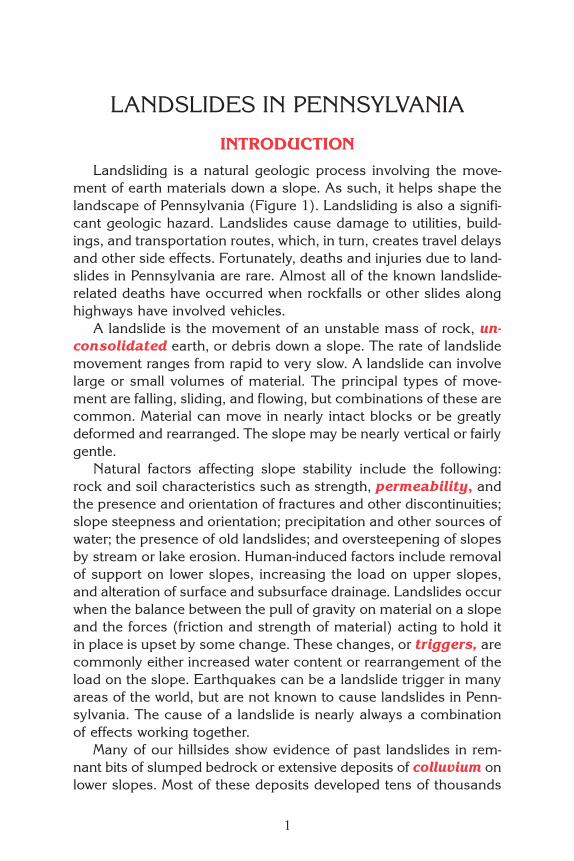
Rock Creep
Description
Rock creep is the slow, gravity-driven, downslope movement ofrock fragments created by near-surface weathering (Figures 2 and3). Rock creep is imperceptibly slow and can be measured only byrepeated observations over a long period of time. Repeated freez-ing and thawing is a major cause of rock creep. Other causes in-clude (1) the growth of plant roots in tiny fractures; (2) the expan-sion and contraction of soil and rock with changing temperature;and (3) the repeated opening and closing of desiccation (drying)cracks. All these factors act to shift particles slowly downslope.
Occurrence
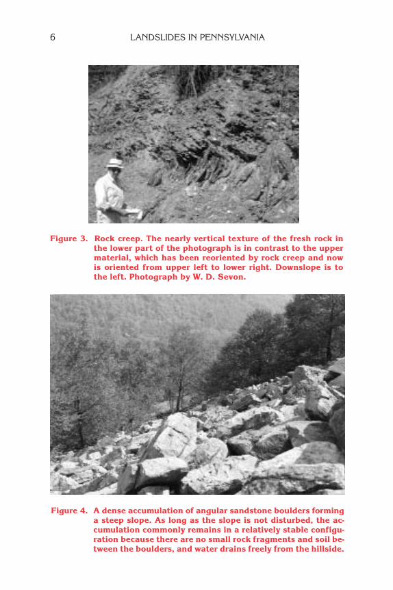
Rock creep is widespread and occurs on many slopes. It cantake place on both gentle and steep slopes throughout the state. Itplays a role in forming and moving soils on slopes. Rock creep ismore pronounced in broken rock that occurs with small- or mixed-size fragments. Movement caused by freezing-thawing and wetting-drying cycles is more effective in the smaller spaces of such ma-terial than in accumulations of large blocks and boulders.
On a number of mountainsides, especially in the Ridge and Val-ley physiographic province, large areas of closely packed angularboulders blanket the steep slopes (Figure 4). Although their ap-pearance is dramatic and suggests instability, in most cases theyare stable. As long as the slopes remain undisturbed by works ofhumans (particularly the removal of material from the base of theslope), the rocks generally stay in place, wedged one against theother, forming tight boulder nests of interlocking pieces that haveapparent long-term stability.
4 LANDSLIDES IN PENNSYLVANIA

Fig
ure
2.
Ch
arac
teri
stic
s o
f ro
ck a
nd
so
il c
reep
sh
own
in
a c
ross
sec
tio
n o
f a
hil
lsid
e. S
and
sto
ne
bo
uld
ers
nea
r th
eto
p o
f th
e h
ill
hav
e w
eath
ered
aw
ay f
rom
th
e p
aren
t ro
ck a
lon
g f
ract
ure
s an
d h
ave
mo
ved
dow
nh
ill.
Sim
ilar
ly,
shal
efr
agm
ents
are
in
th
e so
il d
own
hil
l fr
om
th
eir
sou
rce
rock
. In
th
e m
idd
le o
f th
e h
ills
ide,
a l
imes
ton
e b
lock
has
til
ted
dow
nh
ill.
Nea
r th
e to
e o
f th
e sl
op
e, s
ever
al s
and
sto
ne
bo
uld
ers
fro
m a
bo
ve a
re b
uri
ed o
r p
arti
ally
bu
ried
in
so
il t
hat
ove
rlie
s li
mes
ton
e. T
hes
e si
tuat
ion
s ar
e ty
pic
al o
f co
nd
itio
ns
fou
nd
alo
ng
th
e cr
ests
of
nar
row
rid
ges
in
th
e R
idg
ean
d V
alle
y p
rovi
nce
.
LANDSLIDE CLASSIFICATION 5
6 LANDSLIDES IN PENNSYLVANIA
Figure 4. A dense accumulation of angular sandstone boulders forminga steep slope. As long as the slope is not disturbed, the ac-cumulation commonly remains in a relatively stable configu-ration because there are no small rock fragments and soil be-tween the boulders, and water drains freely from the hillside.
Figure 3. Rock creep. The nearly vertical texture of the fresh rock inthe lower part of the photograph is in contrast to the uppermaterial, which has been reoriented by rock creep and nowis oriented from upper left to lower right. Downslope is tothe left. Photograph by W. D. Sevon.

Talus Creep
Description
Talus creep is closely related to rock creep. Talus is rock wasteat the foot of a cliff or steep slope. It is loose rock rubble that hasbeen separated from the rock face above by weathering and thathas accumulated by rockfall (explained below) on the slope below(Figure 5). It thus builds up as a wedge-shaped deposit. Wherevertalus occurs there will be talus creep, and the same mechanismsthat cause rock creep are the active agents of movement.
The downslope movement of talus is augmented by loading atthe top. Pieces that fall from the steep slope may settle near thetop of the talus rubble. Their weight is an added impetus to down-slope movement. Talus on the lower slope has a larger percentageof fine material, which allows downslope movement by creep.
Soil Creep
Description
Almost every soil-covered slope shows slow downhill movementin response to gravity. The rate of soil creep depends upon the
steepness of the slope, the type of soil, themoisture content, and climatic conditions. Soil
creep is active even on forested slopes. Sur-face evidence of soil creep is commonlyquite noticeable. Fence posts tilted down-hill, fence rows displaced downslope,curved tree trunks, and turf rolls are all
common evidence of soil creep (Fig-ure 6). Trees become concave up-
slope as tree growth respondsto downslope movement
LANDSLIDE CLASSIFICATION 7
Figure 5. A cliff face and a talus accumulation at the foot of the cliff.Rock fragments break away along fractures, which are shownin color.

so that the tree is bent toward the source of light, trying to remainvertical.
There are several causes of soil creep. Water infiltration followedby freezing and thawing plays a major role in downslope move-ment. Other forces causing movement are alternating heating andcooling, desiccation cracking when dry, moisture changes, wedg-ing by growing plants, burrowing by animals, and chemical de-composition. Gravity causes all these forces to produce downslopemovement. Results of the freeze-thaw cycle are apparent on manyslopes. As moisture in the soil freezes, particles are lifted in a di-rection perpendicular to the slope. Then, as the ground thaws,these same particles settle downward by gravity, coming to rest ata point lower on the slope. By this mechanism, a layer of soil nearthe surface will move at a faster rate than the soil at greater depths.However, the slow movement created has substantial effect, and assurface layers are loosened, deeper layers are affected. Soil creepmay accelerate into more rapid flow when the water content of asoil is greatly increased or other conditions affecting slope stabilityare changed. Creep alone is not usually a serious geologic hazard,but over time it is capable of damage such as breaking sewer andwater lines and toppling unsupported walls. Creep may also leadto conditions that result in more drastic slope failure.
8 LANDSLIDES IN PENNSYLVANIA
Figure 6. Effects of soilcreep demonstrated by down-hill displacement of trees,sod, paths, fence posts, andother man-made objects.
OccurrenceCreep occurs on most slopes and is widespread throughout the
state. However, on most hillsides it does not lead to catastrophicslope failure. In cases where creep triggers more pronounced move-ment, the underlying causes of slope instability are already pres-ent. These causes are the same as those at the roots of most otherlandslides, which are weak zones in rock or soil, barriers to freedrainage of water, and fractures or other discontinuites in other-wise strong material.
Earthflow
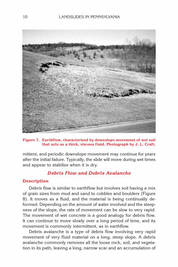
DescriptionEarthflow is a rapid mass movement characterized by down-
slope flow of soil over a discrete basal surface (Figure 7). Bedrockmovement is not involved. The soil is composed mostly of sand andsmaller particles. The basal surface is more or less parallel to theground surface in the lower portion of the flow. There are generallythree distinct parts of an earthflow: (1) a source area; (2) a centralsection of broken and disrupted soil that has open fissures acrossthe flow; and (3) a lower section of raised hummocky ground. Earth-flow is typically the slowest moving of the three types of rapid flowthat occur in Pennsylvania.
Conditions causing earthflow are variable but are most favor-able where soil above an impermeable bedrock surface or claylayer becomes saturated with water. Water fills all of the pore spacein the soil. This adds weight to the mass and reduces the strengthof the soil. The pressure of additional water that cannot drain awayforces the grains to move apart, further reducing the strength ofthe soil and resulting in slope failure even on a gentle incline.
OccurrenceEarthflow is primarily a problem in southwestern Pennsylvania,
being most prevalent in areas where shallow soils are developed onsteep slopes that have clay-rich bedrock. Most natural earthflowsin Pennsylvania occur in the Waynesburg Hills and Pittsburgh LowPlateau sections of the Appalachian Plateaus province. In parts ofthe Waynesburg Hills section, nearly all the slopes show evidence ofancient or recent earthflow. Most individual earthflows are small—at most a few hundred feet long and wide—but multiple earthflows,sometimes of different ages, can combine to create large areas ofinstability. Movement of an individual earthflow is commonly inter-
LANDSLIDE CLASSIFICATION 9
mittent, and periodic downslope movement may continue for yearsafter the initial failure. Typically, the slide will move during wet timesand appear to stabilize when it is dry.
Debris Flow and Debris Avalanche
Description
Debris flow is similar to earthflow but involves soil having a mixof grain sizes from mud and sand to cobbles and boulders (Figure8). It moves as a fluid, and the material is being continually de-formed. Depending on the amount of water involved and the steep-ness of the slope, the rate of movement can be slow to very rapid.The movement of wet concrete is a good analogy for debris flow.It can continue to move slowly over a long period of time, and itsmovement is commonly intermittent, as in earthflow.
Debris avalanche is a type of debris flow involving very rapidmovement of very fluid material on a long, steep slope. A debrisavalanche commonly removes all the loose rock, soil, and vegeta-tion in its path, leaving a long, narrow scar and an accumulation of
10 LANDSLIDES IN PENNSYLVANIA
Figure 7. Earthflow, characterized by downslope movement of wet soilthat acts as a thick, viscous fluid. Photograph by J. L. Craft.
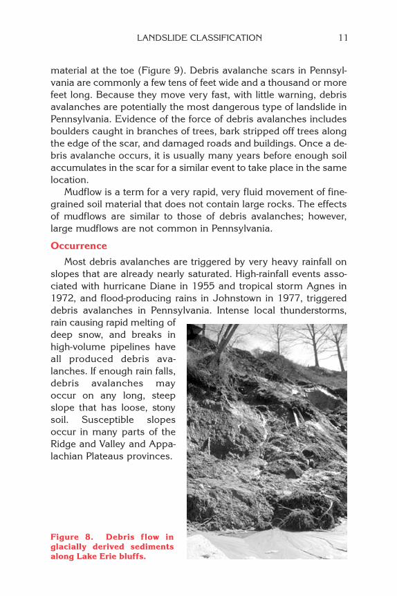
material at the toe (Figure 9). Debris avalanche scars in Pennsyl-vania are commonly a few tens of feet wide and a thousand or morefeet long. Because they move very fast, with little warning, debrisavalanches are potentially the most dangerous type of landslide inPennsylvania. Evidence of the force of debris avalanches includesboulders caught in branches of trees, bark stripped off trees alongthe edge of the scar, and damaged roads and buildings. Once a de-bris avalanche occurs, it is usually many years before enough soilaccumulates in the scar for a similar event to take place in the samelocation.
Mudflow is a term for a very rapid, very fluid movement of fine-grained soil material that does not contain large rocks. The effectsof mudflows are similar to those of debris avalanches; however,large mudflows are not common in Pennsylvania.
Occurrence
Most debris avalanches are triggered by very heavy rainfall onslopes that are already nearly saturated. High-rainfall events asso-ciated with hurricane Diane in 1955 and tropical storm Agnes in1972, and flood-producing rains in Johnstown in 1977, triggereddebris avalanches in Pennsylvania. Intense local thunderstorms,rain causing rapid melting ofdeep snow, and breaks inhigh-volume pipelines haveall produced debris ava-lanches. If enough rain falls,debris avalanches mayoccur on any long, steepslope that has loose, stonysoil. Susceptible slopesoccur in many parts of theRidge and Valley and Appa-lachian Plateaus provinces.
LANDSLIDE CLASSIFICATION 11
Figure 8. Debris flow inglacially derived sedimentsalong Lake Erie bluffs.

Slump
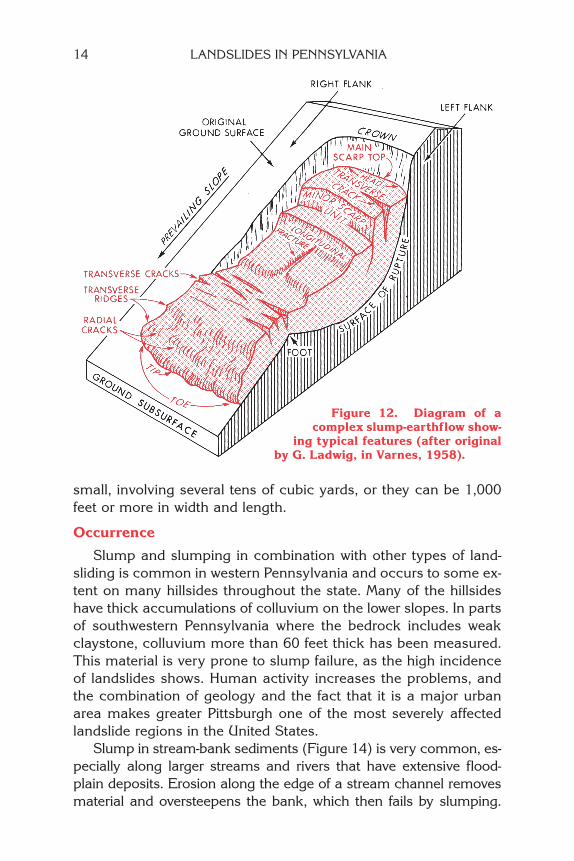
Description
Slump is rotational sliding of rock or unconsolidated materialthat moves as a unit and is characterized by a curved slip surface.The rotation of the moving mass is around a horizontal axis. Theslumped mass is tilted backward into the slope, forming a scarp atthe top and a bulge at the toe (Figures 10, 11, and 12). The sur-face of rupture and slippage is concave upward, and the slumpedmaterial is not greatly deformed. Formation of a semicircular slipsurface is typically an indication that the material is not composedof layers having different strengths. Artificially placed materials
12 LANDSLIDES IN PENNSYLVANIA
Figure 9. This long, narrow scar was created by a debris avalanche.Forest vegetation and most of the soil was stripped awayfrom the upper and middle parts of the slide and depositedlower on the slope.

such as fill and mine waste typically fail by slumping. Slump failurecommonly occurs in thick, uniform soil and weathered rock, but itmay also occur in bedrock. Most identified large bedrock slumpsare very old but can still be active or can be easily reactivated.Slump is most commonly caused by (1) increased moisture con-tent, which decreases strength; (2) removal of support at the toeof a slope; (3) adding material at the top of a slope; or (4) con-struction of a cut or filled slope that is too steep for the materialsinvolved to be stable (Figure 13). Slump failures can be relatively
LANDSLIDE CLASSIFICATION 13
Spoon-shaped slope failure Slump in homogeneous material
Figure 11. Slump failure and the steep scarp at the head above the dis-rupted ground. Photograph by R. P. Briggs.
Figure 10. Internal movement and generalized configuration of thesurface of rupture characteristic of slump failure.
small, involving several tens of cubic yards, or they can be 1,000feet or more in width and length.
Occurrence
Slump and slumping in combination with other types of land-sliding is common in western Pennsylvania and occurs to some ex-tent on many hillsides throughout the state. Many of the hillsideshave thick accumulations of colluvium on the lower slopes. In partsof southwestern Pennsylvania where the bedrock includes weakclaystone, colluvium more than 60 feet thick has been measured.This material is very prone to slump failure, as the high incidenceof landslides shows. Human activity increases the problems, andthe combination of geology and the fact that it is a major urbanarea makes greater Pittsburgh one of the most severely affectedlandslide regions in the United States.
Slump in stream-bank sediments (Figure 14) is very common, es-pecially along larger streams and rivers that have extensive flood-plain deposits. Erosion along the edge of a stream channel removesmaterial and oversteepens the bank, which then fails by slumping.
14 LANDSLIDES IN PENNSYLVANIA
Figure 12. Diagram of acomplex slump-earthflow show-
ing typical features (after originalby G. Ladwig, in Varnes, 1958).

The stream typically removes the slumped material, setting thestage for a repeat performance.
In the northern part of Pennsylvania, glacier ice once dammedmany of the streams. Thick deposits of clay were laid down in theresulting lakes. The ice and lakes are now gone, but the clays re-main, sometimes covered by other sediments. These clays are veryprone to slumping, especially as streams remove material from thetoe, or as roads and buildings are constructed on the upper parts.
Bluffs along the shore of Lake Erie in northwestern Pennsylva-nia fail by periodic slumping as well as by other types of move-ment. The bluffs are 30 to 170 feet high, and are mostly composedof unconsolidated sediment of glacial origin. The wave action ofthe lake removes material at the base of the bluff face, and thebluff face slumps, slides, and flows in response.
Old bedrock slumps are known from valley sides of many of thelarge rivers and streams of Pennsylvania. Most of these probably
LANDSLIDE CLASSIFICATION 15
Figure 13. Small slump in the cut portion of a recent cut-and-fill slope.The slumped material is a thick claystone between layers ofstronger rock.
Figure 14. Slumping along a stream bank.

developed when river erosion deepened the valley beyond a criti-cal point. Most do not show signs of active movement, but they canbe reactivated by construction activities or high-moisture conditions.There are almost certainly many more old bedrock landslides thathave not yet been recognized.
Debris Slide and Debris Fall
Description
Debris slide is the rapid sliding movement of unconsolidated,coarse soil in which the material slides as one or more discreteunits. In this type of sliding, the surface along which movement oc-curs is generally an inclined layer of weak, impermeable soil or thetop of the bedrock. The weak layer may be saturated with water andvery soft, and firmer material rides along on top as the soft mate-rial is deformed. Debris fall is the relatively free falling of unconsoli-dated earth and rock debris from a vertical or overhanging cliff.
Soil and weathered rock typically move slowly down a slope bycreep to a point at which a slope increases in steepness. A debrisslide results after the material reaches the steeper section. If theslope is vertical, the resulting mass movement is debris fall. Othertriggering causes for debris slides are increased soil-moisture con-tent, especially if weak clay material is present near the failure sur-face, and excavation or loading on the slope.
Occurrence
Debris slides and debris falls, either individually or in combina-tion, are common in many areas of Pennsylvania. Colluvium, whichcovers most of the slopes in the commonwealth, is prone to debrisslide, especially if disturbed. Shallow debris slides are common inthe Ridge and Valley and Appalachian Plateaus provinces, espe-cially where roads have been cut into steep slopes. Many small de-bris slides probably go unnoticed in wooded areas where they donot affect human activity.
Rockslide
Description
Rockslide is the movement of newly detached segments of bed-rock sliding on bedding, joint, or fault surfaces or any other surface
16 LANDSLIDES IN PENNSYLVANIA

of separation. Significant bedrock characteristics that determinethe susceptibility of a hillside to rocksliding are (1) the position ofbedding, joint, and fault surfaces with respect to the hillside slope(Figure 15); (2) the extent of weathering; and (3) the presence ofwater- or ice-filled fractures in the rock.
Layered sedimentary rocks, which occur in most of Pennsylva-nia, are particularly prone to rockslide when the layers have beenfolded so that they are no longer horizontal. Where the dip of thebedding planes and fracture surfaces is in the same direction asbut less steep than the angle of a slope surface, rocksliding canreadily occur. A rock slope subject to considerable weathering canhave a large amount of loose rock built up on it, and this materialcan eventually slide.
One of the main triggering agents of slides is increased watercontent, which can reduce friction along potential slide surfaces. Asin other types of landslides, many rockslides begin to move duringor immediately after heavy rainstorms. Increased water alone, how-ever, is not the only initiating factor. The presence of a relativelyweak rock layer on top of an impermeable layer creates a situationwhere the weak layer is easily saturated with water. This is illus-trated in Figure 16. Relatively thick, fractured sandstone and shalebedrock overlies carbonaceous shale and claystone. The bedrockdips gently toward the slope face. Water from rain or melting snowcan percolate down through the sandstone and shales, but slowswhen it reaches the fine-grained claystone below. As water satu-rates the rock units above the claystone, water pressure increasesin the pore spaces in the rock and water concentrates at the top ofthe claystone. The claystone becomes soft and slippery when it iswet, and develops into a potential surface of slippage. Now, anytriggering agent, such as a vibration or sudden increase in precipi-tation, will allow all the water-saturated rock above the claystone tobreak away and slide suddenly toward the valley.
Occurrence
Rockslide is common across most of the Appalachian Plateausand Ridge and Valley provinces in Pennsylvania. It is particularlylikely to occur where dipping rock layers contain interbedded sand-stones and shales or claystones, and where highway or other con-struction activity results in steep slopes being cut into such rocks.
LANDSLIDE CLASSIFICATION 17

18 LANDSLIDES IN PENNSYLVANIA
Fig
ure
15
. A
deb
ris
slid
e an
d r
ock
slid
e in
blo
cky,
ste
eply
in
clin
ed s
and
sto
ne.

SouthwesternPennsylvania has avery high occur-rence of rockslidebecause of the highclay content ofmany of the rocks.Other areas particu-larly prone to natu-ral rockslide be-cause of dippingrocks (Figure 17)are the AppalachianMountain and SouthMountain sectionsof the Ridge andValley province, the
Figure 17. Sandstone bedrock in this highwaycut dips steeply from right to left. Blocks in thetop layer of rock have broken loose from the in-tact rock and are slowly sliding downslope alonga bedding surface. A wide drop zone keeps therock from sliding onto the highway.
LANDSLIDE CLASSIFICATION 19
Potential surfaceof rupture
Potentialslip surface
Fractures
Figure 16. The fractured sandstone and shale in this rock slope is likelyto slide along a slip surface in the soft claystone layer. Theunit can move as a single large block, or it can break up intomany small ones. The numerous fractures will contribute tothe breakup of the rock and allow water to enter the rocksand reduce their strength.

20 LANDSLIDES IN PENNSYLVANIA
Pocono Plateaus section of the Appalachian Plateaus province, andthe Reading Prong section of the New England province.
Some very large, old rockslides are known in the Ridge and Val-ley section. They occur along major streams that have eroded thebase of the slope, and are similar to the rock slumps discussed ear-lier, except that the slide surface is planar rather than curved.
Rockfall and Soil Fall
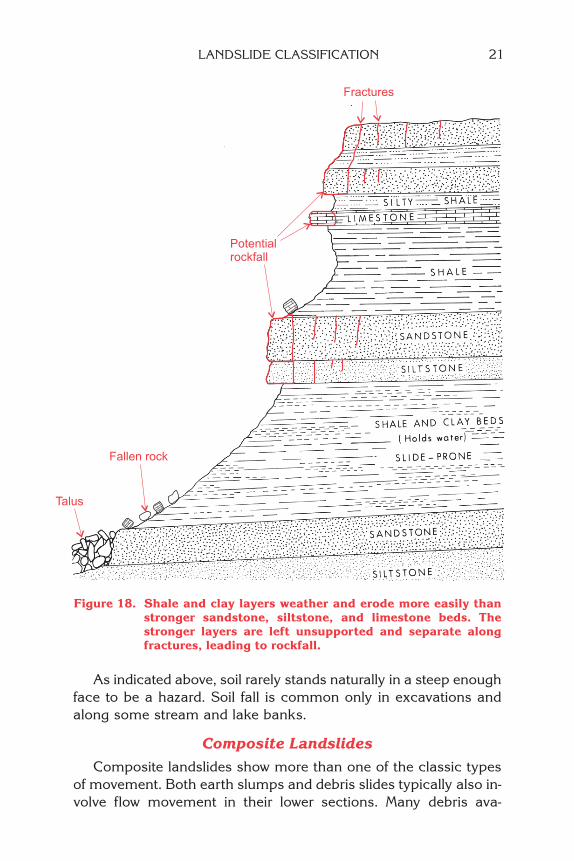
DescriptionRockfall is the free falling of a newly detached unit of bedrock
of any size from a cliff, steep slope, cave roof, or rock arch. Rockfallcan occur as a single event or as a series of single, intermittent eventsover a considerable period of time. Rockfall is most active in thespring after freeze-thaw cycles have loosened pieces of rock alongjoints and bedding-plane fractures, allowing them to fall from a steepslope or cliff face (Figures 18 and 19). Susceptibility to rockfall de-pends mostly on the spacing and orientation of fractures, bedding,and other discontinuities in the rock. Soil fall is the similar fallingof unconsolidated soil, but is much less common than rockfall be-cause soil rarely stands in a steep enough slope for fall to occur.
OccurrenceRockfall can occur from any nearly vertical or overhanging rock
face. It is most common in those parts of Pennsylvania that havemany steep hillsides, but it may occur in any of the physiographicareas. However, since most natural slopes are not steep enough forfall to occur, rockfall is mostly limited to areas where stream ero-sion or human activity removes support at the base of a slope.
Stream banks, highway and railroad cuts, old mine and quarryareas, and other human-made steep slopes are typical settings.The age of a cut is a factor in rockfall. Many fresh cuts seem quitestable, but after a number of years, the rocks weather, fracturesgrow wider and deeper, and blocks loosen. This is a natural process,but one not always anticipated by people traveling or working belowthe cuts.
A combination of rockslide and rockfall is not unusual, espe-cially in the Plateau, where soft, easily eroded shales are commonlyoverlain by more resistant sandstone or siltstone. Erosion of thethick shale near the base of the steep hillside undercuts the moreresistant units, removing support from beneath them and allowingthem to fall or slide to the toe, as illustrated in Figure 18.
As indicated above, soil rarely stands naturally in a steep enoughface to be a hazard. Soil fall is common only in excavations andalong some stream and lake banks.
Composite Landslides
Composite landslides show more than one of the classic typesof movement. Both earth slumps and debris slides typically also in-volve flow movement in their lower sections. Many debris ava-
Potentialrockfall
Fractures
Fallen rock
Talus
Figure 18. Shale and clay layers weather and erode more easily thanstronger sandstone, siltstone, and limestone beds. Thestronger layers are left unsupported and separate alongfractures, leading to rockfall.
LANDSLIDE CLASSIFICATION 21
22 LANDSLIDES IN PENNSYLVANIA
lanches begin with a small area of slump or slide at the head. Thedeposits of an old debris flow may be reactivated as a smaller areaof slumping or sliding. The head scarp of a slump may fail again,producing a progressive series of slumps migrating upslope. Com-posite landslides are probably more common than examples of“pure” types. It is difficult to sort natural occurrences into neat cate-gories, but trying to do so makes it easier to understand how theyare caused.
Human-Induced Landslides
Although landslides do occur naturally, human activities are in-volved in causing a great many of them in Pennsylvania. Human-caused landslides can be of any of the above types, and usually in-volve a natural component as well. The human activities are similarto the common natural triggers for landslides, and include removalof support at the toe, addition of material at the top, or addition ofwater, which reduces the strength of the slope materials. An addi-tional factor, particularly common in southwestern Pennsylvania,
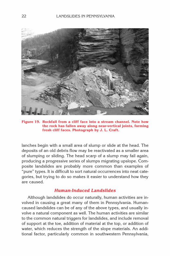
Figure 19. Rockfall from a cliff face into a stream channel. Note howthe rock has fallen away along near-vertical joints, formingfresh cliff faces. Photograph by J. L. Craft.

is building on naturally unstable ground and on old landslides andslide scars. In many cases, a landslide that has moved once willstart to move again with greater ease, because the clay and othermaterials along the surface of rupture have been smoothed andsmeared, and original friction is reduced. Also, fractures and crackson the surface of an old slide allow water to enter the material, thusreducing its strength and adding weight.
The human-induced landslides that are most often seen are inroadcuts along hillsides (Figure 20). Modern roadcuts are gener-ally designed with slide prevention in mind, but there are all toooften unexpected conditions, such as an unknown concentrationof groundwater flow, unexpected weak rock layers, or undetectedfractures, that lead to failure of what was thought to be a stableslope.
Virtually all types of landslides from creep to rapid flow to rock-slide and rockfall can be observed along Pennsylvania’s highways.Many are minor, requiring little or no special maintenance. Othersare massive failures that interrupt construction or temporarily closea completed road to traffic. On a four-lane highway under con-struction in Blair County in the 1970s, for example, 250,000 cubicyards of mountainside slid rapidly onto a completed portion of theroadway. The cost to remove it was more than $300,000.
Figure 20. Slump failure of a road on a cut-and-fill slope.
LANDSLIDE CLASSIFICATION 23

24 LANDSLIDES IN PENNSYLVANIA
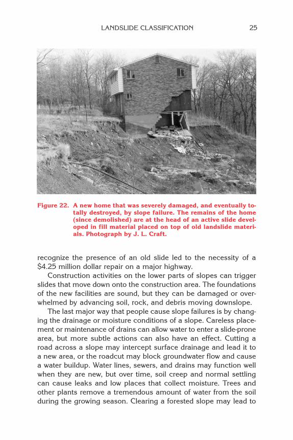
Other types of construction and land modification may affectlandslide occurrence as well. The placement of fill to modify a slopeis a common trigger (Figure 21). The placement of fill on a slopeadds to the load on what may be marginally stable materials. If thefill consists of weak, clay-rich material, or is not installed in com-pacted layers, it may slide or settle, affecting anything built on it.There are numerous examples throughout the state of crackedand damaged buildings, driveways, parking lots, and so on, whichare located on unstable fill that is undergoing progressive failure bycreep or slumping. In too many cases, unhappy homeowners maybe left with cracking walls, breaking pipes, and tight windows anddoors, and they may have little or no recourse to remedial meas-ures. Failure may be complete (Figure 22), causing the total lossof a home.
The placement of fill over old landslides has set off many addi-tional slides, particularly in southwestern Pennsylvania where oldlandslides cover a large portion of the land. In one case, failure to
Potential failure surface
Original ground surface
Original soil/rock contact
Strongrock
Weak rock
Fill
Soil
Soil
Fractures
vv
Figure 21. Some possible effects of the cut-and-fill technique of slopemodification. In the steep excavated face above the house,both soil and rock can fail because of lost support. Belowthe house, the additional load from carelessly placed fillmay trigger slump failure of the underlying soil. Cuttingand filling also allows water to enter slope materials, andcan block free drainage of water from the lower slope.
recognize the presence of an old slide led to the necessity of a$4.25 million dollar repair on a major highway.
Construction activities on the lower parts of slopes can triggerslides that move down onto the construction area. The foundationsof the new facilities are sound, but they can be damaged or over-whelmed by advancing soil, rock, and debris moving downslope.
The last major way that people cause slope failures is by chang-ing the drainage or moisture conditions of a slope. Careless place-ment or maintenance of drains can allow water to enter a slide-pronearea, but more subtle actions can also have an effect. Cutting aroad across a slope may intercept surface drainage and lead it toa new area, or the roadcut may block groundwater flow and causea water buildup. Water lines, sewers, and drains may function wellwhen they are new, but over time, soil creep and normal settlingcan cause leaks and low places that collect moisture. Trees andother plants remove a tremendous amount of water from the soilduring the growing season. Clearing a forested slope may lead to
Figure 22. A new home that was severely damaged, and eventually to-tally destroyed, by slope failure. The remains of the home(since demolished) are at the head of an active slide devel-oped in fill material placed on top of old landslide materi-als. Photograph by J. L. Craft.
LANDSLIDE CLASSIFICATION 25

26 LANDSLIDES IN PENNSYLVANIA
the presence of moisture and loss of soil strength that tree rootshad been contributing to the soil.
Since the time that people started building roads and excavatingfor foundations in Pennsylvania, geologic conditions have changedvery little, but technology has changed considerably. Large exca-vating machinery has been developed that can take massive slicesfrom hills and mountains. We regularly regrade areas for housingand business development, and highway cuts and fills of enormousscale allow us to build in areas that would have been unthinkable withthe hand- and horse-operated equipment of the 1800s, or even thepower equipment of the mid-1900s. Before this ability to move moun-tains, man-induced landslides were not as great a problem as theyare today, because development usually conformed to the existing to-pography. In most areas, the first settlement used the easy-to-developland, and later growth was forced to the less desirable sites. Continu-ing growth will lead to an even greater need to address landslide haz-ards in planning and construction in many areas of Pennsylvania.
EFFECTS AND COSTS OF LANDSLIDES
No one really knows how many landslides occur each year inPennsylvania or how much damage they cause. There is no formalreporting system, but a few efforts have been made to determinetotals. In a 1986 study, more than 700 recent and active landslidesin Allegheny County were identified. U.S. Geological Survey (USGS)landslide-inventory maps indicated thousands of landslides in Alle-gheny and Washington Counties. A 1991 list from the Pennsylva-nia Department of Transportation (PennDOT) showed that therewere 226 problem landslides in Allegheny County, 45 in BeaverCounty, 77 in Armstrong County, and 26 in Tioga County. A USGSlandslide-inventory map showed more than 1,200 recent and 900old slides on one 7.5-minute quadrangle map in Greene County. Astudy by the Pennsylvania Geological Survey included the identifi-cation of 480 recent and active landslides and nearly 1,000 of oldor unknown age in the Williamsport 1- by 2-degree map area innorth-central Pennsylvania.
Landslides cause damage to transportation routes, utilities, andbuildings and create travel delays and other side effects. Fortunately,deaths and injuries due to landslides in Pennsylvania are rare. Al-most all of the known deaths due to landslides have occurred when
rockfalls or other landslides along highways have involved vehicles.Storm-induced debris flows are the only other type of landslide likelyto cause death and injuries. Most Pennsylvania landslides are mod-erate to slow moving and damage things rather than people.
One small landslide in 1990 that involved a broken petroleumpipeline is an extreme example of the costs of related damages.Spilled petroleum products entered a major river, causing city watersystems to shut down. Identified costs of repair of the landslidedamage, cleanup of the spill, technical investigations, legal andcourt costs, and environmental fines were approximately $12 mil-lion. Incalculable costs included the loss of productivity while peo-ple stayed at home because of closed businesses or to care for chil-dren normally in schools that had been closed due to lack of a watersupply, costs for the National Guard to deliver water to neighbor-hoods, costs to the pipeline company and its customers due to busi-ness loss for several months. Although this example is extreme,“associated damages” such as this occur with many landslides.
Most damages are less expensive, but significant. “Backyard”landslides, common in the Pittsburgh area, are usually repaired in-completely or not at all. Cost estimates of several hundred thou-sand dollars for stabilization and repair of a landslide affecting twoor three properties are typical. With repair estimates exceeding thevalue of the properties, abandonment is a frequent “solution.” Home-owners’ insurance usually does not cover landslide damage, al-though insurance may cover some business situations.
The state transportation department and large municipalitieshave substantial costs due to landslide damage and to extra con-struction costs for new roads in known landslide-prone areas. OnePennDOT estimate in 1991 showed an average of $10 million peryear in landslide-repair contracts across the state and a similaramount in mitigation costs in grading projects. A number of high-way sites in Pennsylvania are in need of “permanent” repair at es-timated costs of $300,000 to $2 million each.
A USGS study found that total public and private costs of land-sliding in Allegheny County averaged at least $4 million per yearfrom 1970 to 1976. Information about estimating landslide costswas collected in 2003 as part of another USGS-funded project. Itwas found that documented minimum costs for Allegheny Countyfor 2001 and 2002 together were $3 million in public costs and$650,000 from private funds.
EFFECTS AND COSTS OF LANDSLIDES 27
28 LANDSLIDES IN PENNSYLVANIA
LANDSLIDE PREVENTION AND SOLUTIONS
The easiest way to avoid landslide hazards is to keep construc-tion and development out of landslide-prone areas. This is not veryrealistic in the modern world, so the next best way is to be awareof the hazards and prepare for them. Safe construction in landslideareas is possible, but additional costs of detailed site investigationand design of specially engineered facilities can be high.
Recognizing the existence of the hazard is the most importantstep in controlling it. Once recognized, the hazard potential may bereduced by (1) limiting development in the highest hazard areas,and (2) requiring special construction practices in other areas.Maps showing generalized slide-prone areas are available for muchof Pennsylvania (Figure 23). When a site is being considered for aproject, a specific investigation of the site and surrounding area isnecessary for construction design. Lack of knowledge about groundconditions at and near sites has resulted in many slope failures andhas led to expensive repairs. Repairs of a construction-related land-slide can cost many times more than the original project.
Before undertaking remedial measures, the cause of a slide mustbe understood. Efforts to stabilize a slide or slide-prone slope mayinvolve a variety of approaches, as follows: (1) modification ofdrainage; (2) the building of a retaining structure at the toe, usinga variety of materials; (3) partial removal of slide-prone material andreplacement with more stable material; (4) total removal of slidematerial; or (5) a combination of these. Controlling surface and sub-surface drainage is always an important part of slide prevention andstabilization. Drains may be installed around the head and sides ofa potential slide to direct surface runoff away from the unstablearea. Drains installed within the unstable material can help to dry it.Drainage is commonly combined with other methods to control un-stable ground, the most common method of which is the support ofthe toe of the slope. Deeply embedded steel posts and heavy meshfencing along the toe have been particularly effective at keepingrockslides and rockfalls from entering roadways and other areas. Pe-riodic removal of material is important to keep these barriers actingeffectively. Where landslides occur in otherwise stable ground thathas been altered by construction, the control of mass movement iscommonly easier to accomplish than it is in areas of naturally un-stable ground. Where a natural geologic hazard exists, designingaround it or leaving it undisturbed has given the best results.
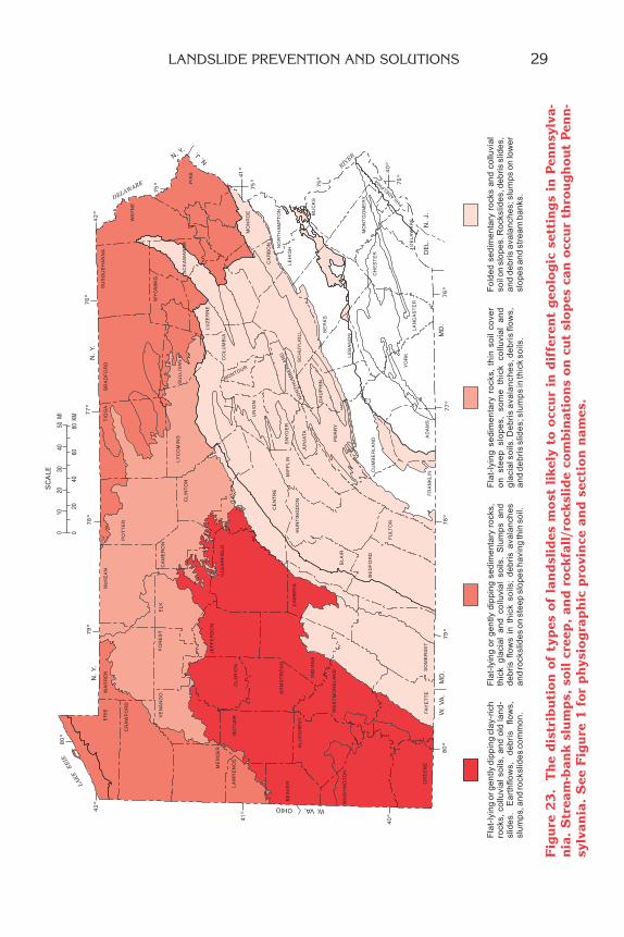
Fig
ure
23
. T
he
dis
trib
uti
on
of
typ
es o
f la
nd
slid
es m
ost
lik
ely
to o
ccu
r in
dif
fere
nt
geo
log
ic s
etti
ng
s in
Pen
nsy
lva-
nia
. S
trea
m-b
ank
slu
mp
s, s
oil
cre
ep,
and
ro
ckfa
ll/r
ock
slid
e co
mb
inat
ion
s o
n c
ut
slo
pes
can
occ
ur
thro
ug
ho
ut
Pen
n-
sylv
ania
. S
ee F
igu
re 1
for
ph
ysio
gra
ph
ic p
rovi
nce
an
d s
ecti
on
nam
es.
LANDSLIDE PREVENTION AND SOLUTIONS 29
30 LANDSLIDES IN PENNSYLVANIA
Even though careful engineering investigation goes into the de-sign of most roads and the foundations of most structures, it is alltoo common for conditions in soil and rock to be different thanwhat was planned for before construction began. Geologic investi-gation of sites before and during construction is a critical aspect ofsafe building in landslide-prone areas.
CONCLUSION
Landslides are a very significant geologic hazard throughout mostof southwestern Pennsylvania and in certain other parts of the state.They are a moderate to minor problem in still other areas that havesteep to moderate slopes. Some kinds of landslides (primarily river-bank slumps and construction-related slides) can occur in any areaif local conditions are “right.”
Deaths and injuries due to landslides are uncommon in Penn-sylvania; however, the average annual direct and indirect cost ofPennsylvania landslides is easily in the tens of millions of dollars. Aspeople continue to develop more land, landslides are likely to be agreater problem unless we work to prevent them. Education, aware-ness, and planning are the most valuable tools in preventing dam-age and injury from landslides. In many cases, problem areas canbe anticipated and avoided. In other instances, appropriate engi-neering and construction measures can allow safe development inlandslide areas, although usually at a greater economic cost. Theextra costs of planning and construction modifications are muchless than the potential losses to property and lives from landslides.
Some information (see below) is available to help identify po-tential landslide problem areas. A few local governments haveadopted landslide consideration as part of their local zoning andbuilding codes, based on this or similar information. This bookletand the references below are intended as general guides, and de-terminations about the stability of a particular site should alwaysbe made by someone qualified and knowledgeable about landslidesand the local geology. Pennsylvania law requires that anyone prac-ticing geology in the state be a Registered Professional Geologist.
Landslides, like other geologic hazards, are a natural phenome-non. They only become a problem when they interfere with humanactivities. An understanding of their occurrence and causes is thefirst step to living safely in landslide areas in Pennsylvania.
GLOSSARY
Bedrock. A general term for the solid rock that underlies soilor other unconsolidated, superficial material.
Bedding plane. The surface separating individual layers insedimentary rocks.
Colluvium. Weathered material that has been transported down-slope by gravity.
Desiccation. Drying up or dehydration. In soils, desiccationcommonly causes cracks to develop.
Dip. The angle that a rock surface makes with the horizontal.Joint. A surface of fracture or parting in a rock other than a
bedding plane.Permeability. The ability of a material to allow fluid to pass
through it.Scarp. A cliff or steep face produced by differential movement
of adjacent blocks along a slide plane.Talus. Rock fragments of any size or shape derived from and
lying at the base of a cliff or very steep, rocky slope.Trigger. Immediate or final cause, as distinct from other con-
tributing causes.Unconsolidated material. Loose material that is not cemented,
compacted, or otherwise made into rock.Weathering. The breakdown of rocks and minerals by physi-
cal and chemical processes near the earth’s surface.
MORE INFORMATION ON LANDSLIDES1
Web Sites
Kansas Geological Survey—Landslides in Kansaswww.kgs.ku.edu/Publications/pic13/pic13_1.html
Ohio Geological Survey—Landslides in Ohiowww.ohiodnr.com/geosurvey/geo_fact/geo_f08.htm
U.S. Geological Surveylandslides.usgs.gov/index.html
West Virginia Geological Survey—Homeowner’s Guide to GeologicHazards
www.wvgs.wvnet.edu/www/geohaz/geohaz3.htm
1Web addresses are subject to change.
MORE INFORMATION ON LANDSLIDES 31

32 LANDSLIDES IN PENNSYLVANIA
Books and Other Publications
If your local library does not have these, it can obtain them throughinterlibrary loan from a larger public or university library.
General information on landslides (Ordering information forthe first two books can be found at www.aipg.org.)
Creath, W. B., 1996, Homebuyers’ guide to geologic hazards: West-minster, Colo., American Institute of Professional Geologists, 30 p.
Nuhfer, E. B., Proctor, R. J., and Moser, P. H., 1993, Citizens’ guideto geologic hazards: Westminster, Colo., American Institute ofProfessional Geologists, 134 p.
Spiker, E. C., and Gori, P. L., 2000, National landslide hazards miti-gation strategy—A framework for loss reduction: U.S. Geologi-cal Survey Open-File Report 00–450, 49 p.
Turner, A. K., and Schuster, R. L., eds., 1996, Landslides—investiga-tion and mitigation: Washington, D. C., National Academy Press,Transportation Research Board Special Report 247, 673 p.
Varnes, D. J., 1958, Landslide types and processes, in Eckel, E. B.,ed., Landslides in engineering practice: National Research Coun-cil, Highway Research Board Special Report 29, p. 20–47.
Maps of 1- by 2-degree quadrangles as shown in Figure 24 (Let-ters following each reference correspond to those in the figure.)
Davies, W. E., Olmacher, G. C., and Pomeroy, J. S., 1978, Land-slides and related features, Ohio, West Virginia, and Pennsylva-nia—Canton 1 by 2 degree sheet: U.S. Geological Survey Open-File Report 78–1057, 118 maps. [D]
Delano, H. L., and Wilshusen, J. P., 1999, Landslide susceptibilityin the Williamsport 1- by 2-degree quadrangle, Pennsylvania:Pennsylvania Geological Survey, 4th ser., Environmental GeologyReport 9, 192 p. [A]
Hackman, R. J., and Thomas, R. E., 1978, Landslides and relatedfeatures, Ohio, West Virginia, and Pennsylvania—Clarksburg 1degree by 2 degree sheet: U.S. Geological Survey Open-File Re-port 78–1056, 128 maps. [E]
Pomeroy, J. S., 1981, Landslides and related features, Pennsylva-nia—Warren 1 degree by 2 degree sheet: U.S. Geological SurveyOpen-File Report 81–238, 112 maps. [B]
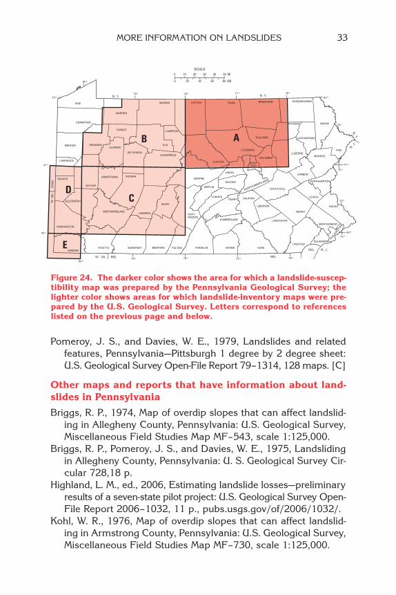
Pomeroy, J. S., and Davies, W. E., 1979, Landslides and relatedfeatures, Pennsylvania—Pittsburgh 1 degree by 2 degree sheet:U.S. Geological Survey Open-File Report 79–1314, 128 maps. [C]
Other maps and reports that have information about land-slides in Pennsylvania
Briggs, R. P., 1974, Map of overdip slopes that can affect landslid-ing in Allegheny County, Pennsylvania: U.S. Geological Survey,Miscellaneous Field Studies Map MF–543, scale 1:125,000.
Briggs, R. P., Pomeroy, J. S., and Davies, W. E., 1975, Landslidingin Allegheny County, Pennsylvania: U. S. Geological Survey Cir-cular 728,18 p.
Highland, L. M., ed., 2006, Estimating landslide losses—preliminaryresults of a seven-state pilot project: U.S. Geological Survey Open-File Report 2006–1032, 11 p., pubs.usgs.gov/of/2006/1032/.
Kohl, W. R., 1976, Map of overdip slopes that can affect landslid-ing in Armstrong County, Pennsylvania: U.S. Geological Survey,Miscellaneous Field Studies Map MF–730, scale 1:125,000.
MORE INFORMATION ON LANDSLIDES 33
Figure 24. The darker color shows the area for which a landslide-suscep-tibility map was prepared by the Pennsylvania Geological Survey; thelighter color shows areas for which landslide-inventory maps were pre-pared by the U.S. Geological Survey. Letters correspond to referenceslisted on the previous page and below.

Pomeroy, J. S., 1978, Map showing landslides and areas most sus-ceptible to landsliding, Butler County, Pennsylvania: U.S. Geologi-cal Survey, Miscellaneous Field Studies Map MF–1024, 2 sheets,scale 1:50,000.
________ 1980, Storm-induced debris avalanching and related phe-nomena in the Johnstown area, Pennsylvania, with references toother studies in the Appalachians: U.S. Geological Survey Pro-fessional Paper 1191, 24 p.
________ 1982, Landslides in the Greater Pittsburgh region, Penn-sylvania: U.S. Geological Survey Professional Paper 1229, 48 p.
________ 1982, Mass movement in two selected areas of westernWashington County, Pennsylvania: U.S. Geological Survey Pro-fessional Paper 1170–B, 17 p.
________ 1986, Map showing slope movements in the Oak Forestquadrangle, Greene County, southwestern Pennsylvania; U.S.Geological Survey Miscellaneous Field Studies Map MF–1794,scale 1:24,000.
________ 1986, Slope movements in the Warren-Allegheny Reser-voir area, northwestern Pennsylvania: U.S. Geological Survey,Bulletin 1650, scale 1:50,000.
Pomeroy, J. S., and Davies, W. E., 1975, Map of susceptibility tolandsliding, Allegheny County, Pennsylvania: U.S. Geological Sur-vey Miscellaneous Field Studies Map MF–685B, 2 sheets, scale1:50,000.
34 LANDSLIDES IN PENNSYLVANIA

ADDITIONAL COPIES OF THIS PUBLICATIONMAY BE OBTAINED FROM
PENNSYLVANIA GEOLOGICAL SURVEY3240 SCHOOLHOUSE ROAD
MIDDLETOWN, PA 17057–3534717–702–2017
PENNSYLVANIA GEOLOGICAL SURVEYEDUCATIONAL SERIES
ES 1 Rocks and Minerals of PennsylvaniaES 2 Common Fossils of PennsylvaniaES 3 The Geology of Pennsylvania’s GroundwaterES 4 The Geological Story of PennsylvaniaES 5 Geology and the Gettysburg CampaignES 6 Pennsylvania and the Ice AgeES 7 Coal in PennsylvaniaES 8 Oil and Gas in PennsylvaniaES 9 Landslides in PennsylvaniaES 10 Earthquake Hazard in PennsylvaniaES 11 Sinkholes in PennsylvaniaES 12 The Nonfuel Mineral Resources of PennsylvaniaES 13 Reading and Using Maps

An Equal Opportunity/Affirmative Action Employer 2200–BK–DCNR3086
Recycled Paper
Recommended


![APPENDIX [A] PROPOSAL COVER SHEET COMMONWEALTH OF ... APPENDIX [A] PROPOSAL COVER SHEET COMMONWEALTH OF PENNSYLVANIA DCNR RFP# _____ Enclosed in three separately sealed submittals](https://img.pdfslide.us/doc/110x75/5d56d61688c993bf378ba7d8/appendix-a-proposal-cover-sheet-commonwealth-of-appendix-a-proposal-cover.jpg)