I I I
Reidsvill,e
I I------, I I I
�,DANVILLE
CA�SV./E.Lt_
Burlington GU!LFOHD I
...l.l .. � __ ..!....,::::_�...J
GREENSBdRO
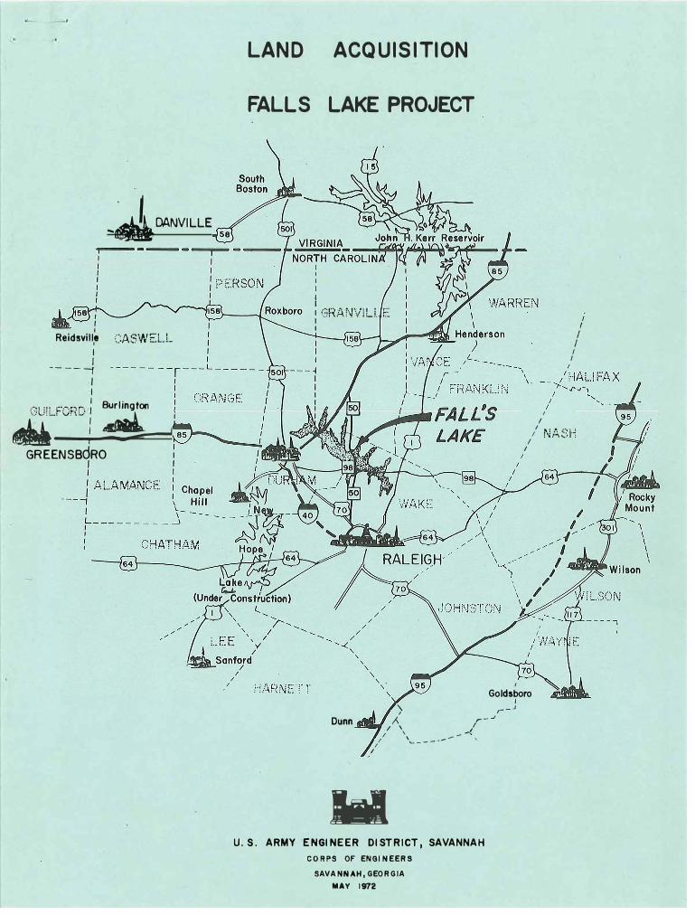
LAND ACQUISITION
FALLS LAKE PROJECT
I I I I I I : \:+,.Ar··�ViLt E: I
I I
I I
I I I I
/ N/��:H
I
I I
Goldsboro I
Dunn
/
'\ ,--J
J r- J
I \ / I \\ - - ..-..,
1' '------
.. U.S. ARMY ENGINEER DISTRICT, SAVANNAH
CORPS OF ENGINEERS
SAVANNAH, GEORGIA
MAY 1972


IN REPLY REFER TO
DEPARTMENT OF THE ARMY SAVANNAH DISTRICT. CORPS OF ENGINEERS
P.O. BOX 889 SAVANNAH. GEORGIA 31402
AN OPEN LETTER TO THOSE PERSONS INTERESTED IN OR AFFECTED BY THE FALLS LAKE PROJECT, NORTH CAROLINA
The U.S. Army Corps of Engineers as directed by Congress has responsibility for execution of approved river development and flood control projects, The Falls Lake Project is one of those projects for which the Corps of Engineers is responsible. The benefits from this project are flood control, water quality downstream,.wa~er supply for muni~ipal and industrial use ,' and recreation and wildlfre 'enhancement. The most immediate benefit to be realized is a dependable water supply for the City of Raleigh and those areas around Raleigh to which the City furnishes water for municipal and industrial purposes.
The law authorizing the Falls Lake Project is in some instances different from previous projects. One of the main differences is that the State of North Carolina will participate in the costs of land and development required for recreational purposes and will manage the Lake and fringe lands for recreational and wildlife purposes. The City of Raleigh will participate in the costs of the construction necessary to impound water for municipal and industrial purposes,
The Savannah District, Corps of Engineers; has real estate acquisition responsibility for the project. Construction of the dam and operation of the project, after construction, are the responsibility of the Wilmington Engineer District.
The acquisition of land for the project is of immediate concern- to those landowners being affected. For this reason this pamphlet has been prepared, The method and procedures are established by laws and regulations, and the Corps of Engineers' personnel are directed to strive earnestly to acquire in a fair and equitable manner the lands necessary for the project, The information contained herein is based on laws and regulations which are designed to protect both the property owner and the United States Government .
This pamphlet provides general information on some of the most common questions concerning purchase of land in the Falls Lake area. The answers are not all-inclusive as there will be many questions which concern individual properties.

It is the policy of the Corps of Engineers to have a sympathetic
understanding of the problems which will necessarily arise as a result of the construction of this project, and to render any possible assistance to affected landowners insofar as permitted by existing laws and
regulations.
or any
them with
obtain accu-
When questions concerning the acquisition of property
matters related thereto arise, please feel free to discuss
the Government project personnel. Th s ;,r the only way torate information on a timely basis. / �:;;;;_.. ... 14._
April 1972
2
HOWARD L. STROHECKER
Colonel, Corps of Engineers District Engineer

FALLS LAKE PROJECT NEUSE RIVER, NORTH CAROLINA
PLAN VIEWS
:==--=-...- - --:.... ::. --
,,. -- --::.-
PERSPECTIVE ~
OUTLET
F,C. POOL EL.26~if5 ~NSTREAM
CONSV. POOL , =~ SIDE EL. 250.1 f~?~;~ :·.. \
CROSS SECTION THROUGH
0 0
OUTLET WORKS NO SCALE
REAL ESTATE ACQUISITION
I O I 2 3
SCALE IN MILES
OAMSITE
I


POWER BOATING
SAILING

JI
. ., ..... . .. - ' . .:C...X•.:: . .
• ..!,. .... . .... ·•' .. ' _., ._ I . ' . .., ,... . -II ,
• \ ~, tJ
'.
, I
-,,-\ i .
SWIMMIN G
PICNICKING

..
FISHING
MARINA
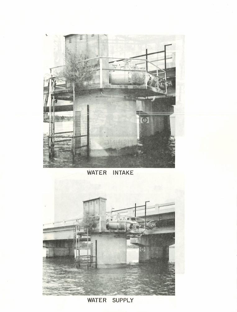
WATER INTAKE
.---
e=
WATER SUPPLY
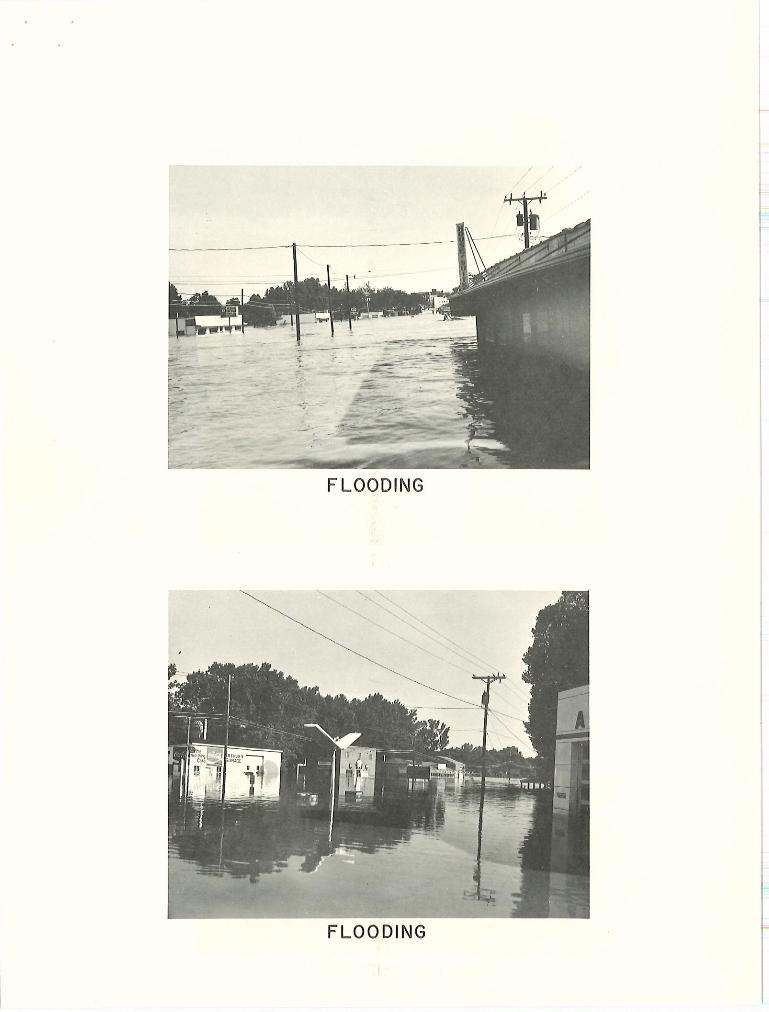
FLOODING
FLOODING

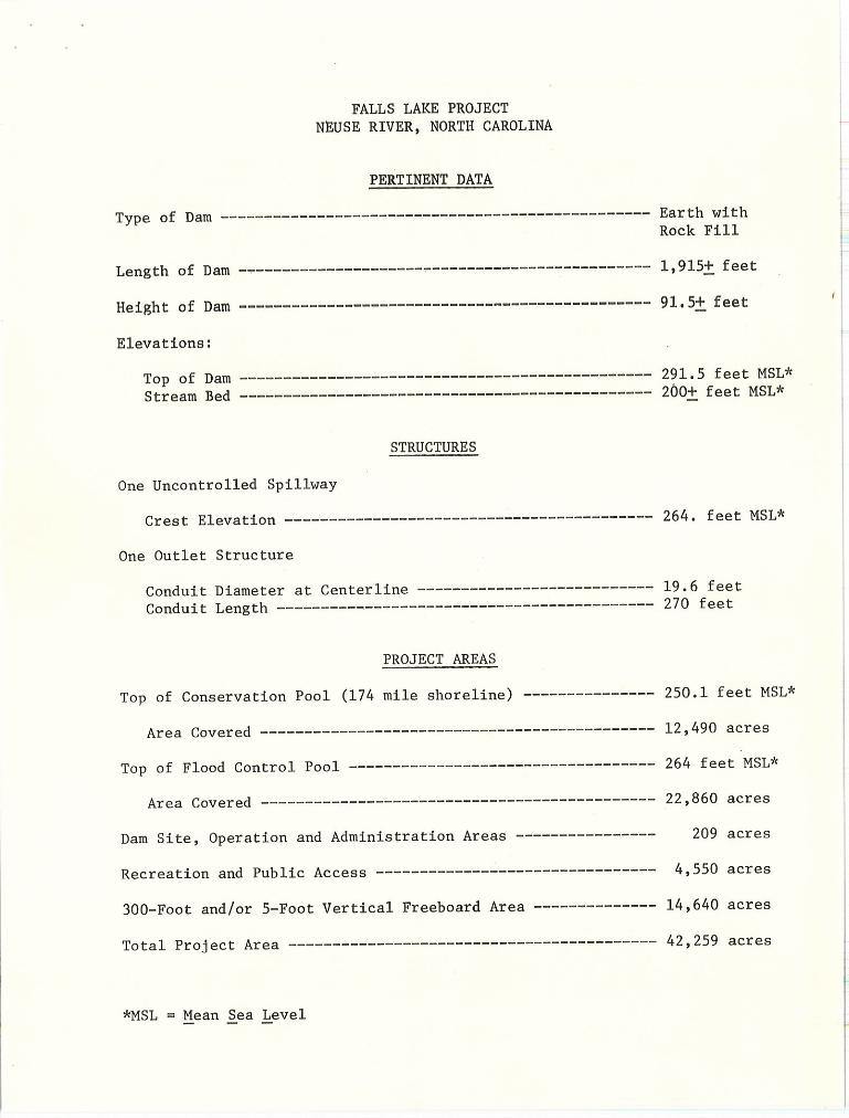
FALLS LAKE PROJECT NEUSE RIVER, NORTH CAROLINA
PERTINENT DATA
Type of Dam------------------------------------------------- Earth with Rock Fill
Length of Dam----------------------------------------------- 1,915± feet
Height of Dam----------------------------------------------- 91,5± feet
Elevations:
Top of Dam----------------------------------------------- 291.5 feet MSL*
Stream Bed----------------------------------------------- 200+ feet MSL*
STRUCTURES
One Uncontrolled Spillway
Crest Elevation------------------------------------------ 264. feet MSL*
One Outlet Structure
Conduit Diameter at Centerline--------------------------- 19.6 feet Conduit Length------------------------------------------- 270 feet
PROJECT AREAS
Top of Conservation Pool (174 mile shoreline)--------------- 250.1 feet MSL*
Area Covered---------------------------------------------
Top of Flood Control Pool-----------------------------------
Area Covered---------------------------------------------
Dam Site, Operation and Administration Areas---------------
Recreation and Public Access--------- ----~------------------
300-Foot and/or 5-Foot Vertical Freeboard Area-------------
Total Project Area------------------------------------------
*MSL = Mean Sea Level
12,490 acres
264 feet MSL*
22,860 acres
209 acres
4,550 acres
14,640 acres
42,259 acres

FALLS LAKE PROJECT NEUSE RIVER, NORTH CAROLINA ACQUISITION OF REAL ESTATE
INTRODUCTION
The purpose of this pamphlet is to furnish as much information as
is available at the present time concernin~ land acquisition for the Falls
Lake Project, and particularly to inform those whose lands will be affected
and the affected communities about the project.
Public Law 89-298, enacted by the 89th Congress on October 27, 1965,
authorized the comprehensive development of the Falls Lake Project substan
tially in accordance with the recommendations of House Document No. 175 - ,
89th Congress, at an estimated cost exceeding $18,000,000. Section 4 of the
Flood Control Act of 1944, as amended in 1946, 1954 and 1962, provides basic
legislation for the overall plan of development and utilization of the Neuse
River.
As recommended by the United States Army Chief of Engineers, the
major project purposes include flood control, water supply for municipal and
industrial use, water for additional irrigation, increased flow for water
quality control in conjunction with sewage treatment, and water . areas for
recreation and fish and wildlife enhancement.
The policy of the Department of the Army, governing the acquisition
of land for reservoir projects, is published in 31 Federal Register 9108 dated
2 July 1966. The current policy is to acquire only adequate interests in lands
necessary and sufficient for the realization of optimum project objectives.
1
The Falls dam site is located on the Neuse River in Wake County,
near the village of Falls, North Carolina, and at river-mile 189 above
New Bern, The dam site is in the upper part of the Neuse River Basin, approx
imately 10 miles north of Raleigh and 17 miles east-southeast of Durham. The
project area as a whole lies along a 22 mile axis beginning at the dam site
and ending 8 miles north of Durham. About one-half of the project area is in
Wake County, three-eighths in Durham County, and one-eighth in Granville County.
The dam site will be earth fill with a height of 91,5 feet and an
overall length of 1,915 feet.
Construction of the project will require some relocation of highways,
railroads, telephone lines, power lines and other utilities, as well as ceme
teries. Plans are now being developed for all of these relocations which will
be completed before waters are impounded in the lake .
A Resident Engineer's Office for construction will be established
near the dam site . The construction phase will be under the direction of the
District Engineer, Wilmington District, U, S. Army Corps of Engineers.
GENERAL LAND ARFA
It is estimated a total of approximately 42,259 acres of land will
be required for the project . Beginning at the site of the dam, acquisition of
land will normally proceed upstream to the extremity of the reservoir. · There
may be instances, however, because of urgent construction requirements, phasing
of relocations or owner hardship which will require variations from this
procedure. Preliminary work has started for land acquisition. A map outlining
the general area required for project purposes is attached to the back of this
pamphlet.
The joint policies of the Department of the Interior and the
Department of the Army, in accordance with the law established by Congress for
2
acquisition of lands at Federal projects, require that fee title be acquired
to all lands below an elev~tion designated as a reasonable freeboard for wave I
action, erosion, etc., or a m_inimum of .300 feet measured horizontally from the
top of the flood control pool, whichever i~ greater. At the Falls project
this "reasonable freeboard" has been determined to be 5 feet measured verti
cally abov~ the flood control pool. The final acquisition limits established
based upon the ab_ove criteria :Will consist of short t_angent lengths closely
aligned with and as parallel as possible to the guide taking corrtour, which
will facilitate final descriptions through use of metes and bounds, In
addition to the above-mentioned lands, additional land will be required for
public access to the reservoir, project operations, and recreation.
Public recreational facilities to be constructed by the Corps of
Engineers will generally consist of access roads, parking areas, boat launch
ings ramps and picnic and campsites with sanitary facilities and potable water.
The North Carolina Wildlife Resources Connnission has requested several separate
management areas to be licensed to the State of North Carolina to mitigate loss
of wildlife resources and to enhance fishing enjoyment and general recreational
development. These areas are generally confined within the guide acquisition
line. It is anticipated these facilities will be supplemented by additional
development of public park areas by other (non-federal) agencies and marinas
which will be operated on a concession basis .
In the acquisition of land, it is a practice to acquire only that
land which is required for project purposes and includes the areas referred to
3
above for public use and recreation; however, the exact area to be acquired
in each instance must be determined by the facts in each individual case .
Completion of the project is contingent upon annual appropriation
of funds by Congress, and funds for the acquisition of land are included in
the construction program. Every effort will be made to inform landowners
sufficiently in advance of the time their properties will be required so
they can relocate themselves with the least possible inconvenience.
4

LAND .ACQUISITION PROCEDURES
1. Determination of Ownerships:
County land records are searched to ·determine ownerships of land required
for project purposes and to obtain legal descriptions. Boundaries of exterior
tracts will be approximately located on the ground . Where only a part of an
ownership is acquired, the boundary between the part acquired and the remainder
' ' will be surveyed and staked at no expense to the landowner.
2. Survey and Mapping:
The landowner's initial contact will most probably be with a representa
tive. of the contractor's surveying party who will discuss the. work to be
accomplished and will obtain necessary permits and rights-of-entry to accomplish
the property identification on site. Mo~r~, Gardner & Asspciates, Inc. of
Asheboro, North Carolina are under contract to perform the mapping and surveying
under the supervision of the U. S. Army Corps of Engineers.
3. Title Evidence:
The firm of Reynolds, Farmer & Russell, Attorneys At Law, Raleigh, North
Carolina are under contract to f urnish title, evidence in the form of Interim
Binders and Title Policies under the supervision of the U. S. Army Corps of
Engineers. This work will be done without expense to the l andowner.
4. Appraisals:
Each individual ownership will be appraised by a qualified appraiser.
These appraisals may be accomplished either by Corps of Engineers staff
5
appraisers, by contract appraisers or by both. The owners will be invited to
inspect the properties with the appraiser, or the owner may designate a repre
sentative for this purpose. The appraiser, in arriving at his conclusion of
value, studies the property and applies the appraisal technique to determine
the fair market value. Standing timber on a tract is always evaluated and
considered in the appraisal with the value of standing timber being established
based upon the current market for merchantable timber. Any special features
which the landowner may wish to point out will be welcomed and considered.
The Constitution of the United States requires the owner be paid
"just compensation" in any acquisition of private property for public use. This
has been determined by the courts to mean "fair market value," or that amount
which would be agreed upon between a willing seller and a willing buyer, neither
of them being obligated to buy or sell.
5. Negotiations:
After the property is appraised and the appraisal is reviewed and approved
by the Project Reviewing Appraiser, a representative of the U. S, Army Corps of
Engineers Real Estate Project Office will contact the landowner to discuss the
acquisition of the individual property. The condition of the title, any ques
tions concerning back taxes, mortgages, liens, and the date the Government will
require possession of the land will be discussed. It is the policy of the Corps
of E~gineers that negotiations be on a practical and realistic basis in the
manner which would normally be conducted between a willing buyer and a willing
seller. Before the initiation of negotiations, an amount will be established
as just compensation and a prompt offer will be made to acquire the property
6

for the full amount so established. In no event shall such amount be less
than the approved appraisal of the fai~ market value of the property. The
owner will be provided with a written statement of, and a summary of the basis
for, the amount established as just compensation, Every effort will be made
by the Government's representative to reach agreement as to price, reservation
of improvements, and continued occupancy, in order to avoid legal proceedings.
While it is realized that the owner has every right to cut and/or sell his
timber before his land is acquired, the Government prefers to purchase standing•
timber with the· land, particularly on those tracts not wholly covered by water,
Frequently areas selected for their forest cover as potential recreational areas
are denuded through timber sales prior to acquisition by the Government, thereby
necessitating years of re-forestation before it can recover its former desira
bility, Standing hardwood and conifers are desirable in the establishment of
nature areas and recreational sites; consequently~ every effort is expended to
preserve the natural forest around reservoir projects thiough purchase of stand
ing timber, Timber clearing is required only in those areas which will be
flooded by the conservation pool .
If agreement is reached on the purchase price, the owner will be
asked to sign an 110ffer to Sell Real Property. 11 This offer fully sets forth
the terms and conditions of the sale . Payment can ordinarily be made within
60 days provided the title is marketable.
6. Condemnation:
After every reasonable effort has been made in discussion with the landowner
and the Government representative and an acceptable agreement cannot be reached,
7

it will be necessary to acquire title to the property through court proceedings .
The Fifth Amendment to the Constitution guarantees that just compensation will
be paid when private lands are acquired for public use. To assure the landowner
of receiving just compensation, the Government institutes a proceeding normally
referred to as "condemnation" to obtain title to the property. Normally an
instrument called a Declaration of Taking is filed with the Federal Court having
jurisdiction over the area in which the land is located. At the same time, the
amount of the Government's estimate of value is deposited with the court.
When the Judge signs the order of the court on the filing of the petition for
condemna t i on, wit h a Decl aration of Taki ng, ind t he estimated compensation is
deposited, title passes to the Government, and inunediately thereafter the
landowner may make application for the funds that have been deposited with the
court. This makes funds available for acquiring a replacement. Final determina
tion of value is made by the court either through trial by jury or a connnission .
At the trial, the landowner, as well as the Government, is permitted to intro
duce testimony supporting his opinion of value . Court costs in condemnation
proceedings are paid by the Government; however, the landowner is required
to pay his attorney's fees, witnesses and any other expenses which he incurs.
The same as in the cases where the landowner and the Government are
able to reach an agreement, a reasonable time is given for the owner to find a
replacement site before he is required to move from the property.
7. Expenses of Landowner:
Regardless of how property is acquired, whether by direct purchase or
condemnation proceedings, the owner will be required to bear certain expenses,
8

some of which are reimbursable,
a, Recording fees, transfer taxes and similar expenses will
be borne by the owner who will be reimbursed by the U, S,
Army Corps of Engineers.
b, Mortgages, mechanic's liens and other leins and enc,umbrances
must be paid by t~e owner at the time of conveyance to the
United States. Arrangements can be made with the Government
for payment of these items by deduction of the amount thereof
from the purchase price of the land. If there is a mortgage
prepayment penalty charged by the mortgage holder, you may
be reimbursed for it.
c. Real Property taxes which you have paid in advance will be
reimbursed at the rate of 1/12 of the total of each month
of the year in which you were not in possession because of
the Government requirement for possession of the property.
8. Expenses Paid by the Government:
The Government will bear expense for surveying, appraising, necessary titl~
evidence and recording the Deed to the United States.
9. Continued Occupancy:
Every effort will be made to accommodate affected landowners in the
acquisition of their property. Generally, our program is scheduled so that
continued occupancy may be permitted without charge until the end of the calendar
year. Only in unusual circumstances will occupancy be permitted for longer than
one year, and then only with a lease agreement with the former owner and the
payment of rental to the Government.
9

10 . Relocation:
Public Law 91-646, enacted by the 91st Congress on January 2, 1971,
entitled the "Uniform Relocation Assistance and Real Property Acquisition
Policies Act of 1971" provides for uniform and equitable treatment of persons
displaced from their homes, businesses or farms by Federal or federally-
assisted programs. The Government will provide a Relocation Assistance Advisory
Service to insure fair and reasonable assistance to all persons who are displaced
by this project.
In addition, the Government , wi th cer t a in limi t a tions, wi l l r eimburse
both owners and tenants for expenses and other losses or damages which they
incur in the process of and as a direct result of moving themselves, their
families and their possessions, because of acquisition by the Government.
Brochures will be mailed to each individual required to relocate, setting forth
fully his right to reimbursement, what costs will be reimbursed and the necessity
for furnishing itemized statements . It is pointed out here that no reimburse
ment will be made for expenses incurred by the reservation and removal from the
premises of any buildings or other improvements for which payment has been made
at their fair value and reserved by the landowner for salvage value.
11. Cemeteries:
Generally, all cemeteries within the project area will be relocated. This
work will be conducted with dignity, profound respect and full consideration
for the sentiments of living relatives. Reinterment will be made in new sites
located outside the reservoir, or in existing cemeteries within the locality .
10

Permission to remove remains from cemeteries will be sought from the next of
kin, if they can be ascertained and located with reasonable effort . If the
next of kin desires to remove the remains to some distant point, the Govern
ment's contractor will contribute to the cost of the move an amount not in
excess of that which would have been incurred by interment in one of the new
cemeteries.
12 . Further information may be obtained from
North Carolina Area Real Estate Office U. S. Army, Corps of Engineers Post Office Box 99 (109 Ward Street) Cary, North Carolina 27511 Telephone No. (919) 467-8112
11


' -- -- -- -- .J
COIUCWAlL ltO.
r-- ,--C_J y~ i
8
I I
-- __ J
CORP
AR EA RE
L-~o_:::_ __
OF ENGINEERS
L ESTATE OF ICE
COIIHWALL
a 0 0 s 2: l,j
CARY, N. C.
T.
,, ,, fl ,, ,,
II ..
©
0 . 0 .


CORPS OF ENGINEERS
00
780
0 N 0 N
+ U. 5. ARMY
LEGEND
MAJOR HIGHWAYS (STATE 8 FEDERAL)
SECONDARY ROADS
CCU,,TY LINE
CITY LIM ITS
- 264- TOP OF FU)(X) CONTROL POOL
"""7-2501,mrr TOP OF CONSERVATION POOL
RESERVOIR LANDS
PUBLIC USE LANDS
LAK E PROJECT NEUSE RIVER BASIN
NORTH CAROLINA
LAND ACQUISITIONS
CORPS OF ENGINEERS
U.S. ARMY ENGINEER OISTRICT
SAVANNAH
SAVANNAH, GEORGIA
4000 2000 0 4000 8000 12000
SCALE IN FEET
PLATE


Recommended