April 2017 | P16-191
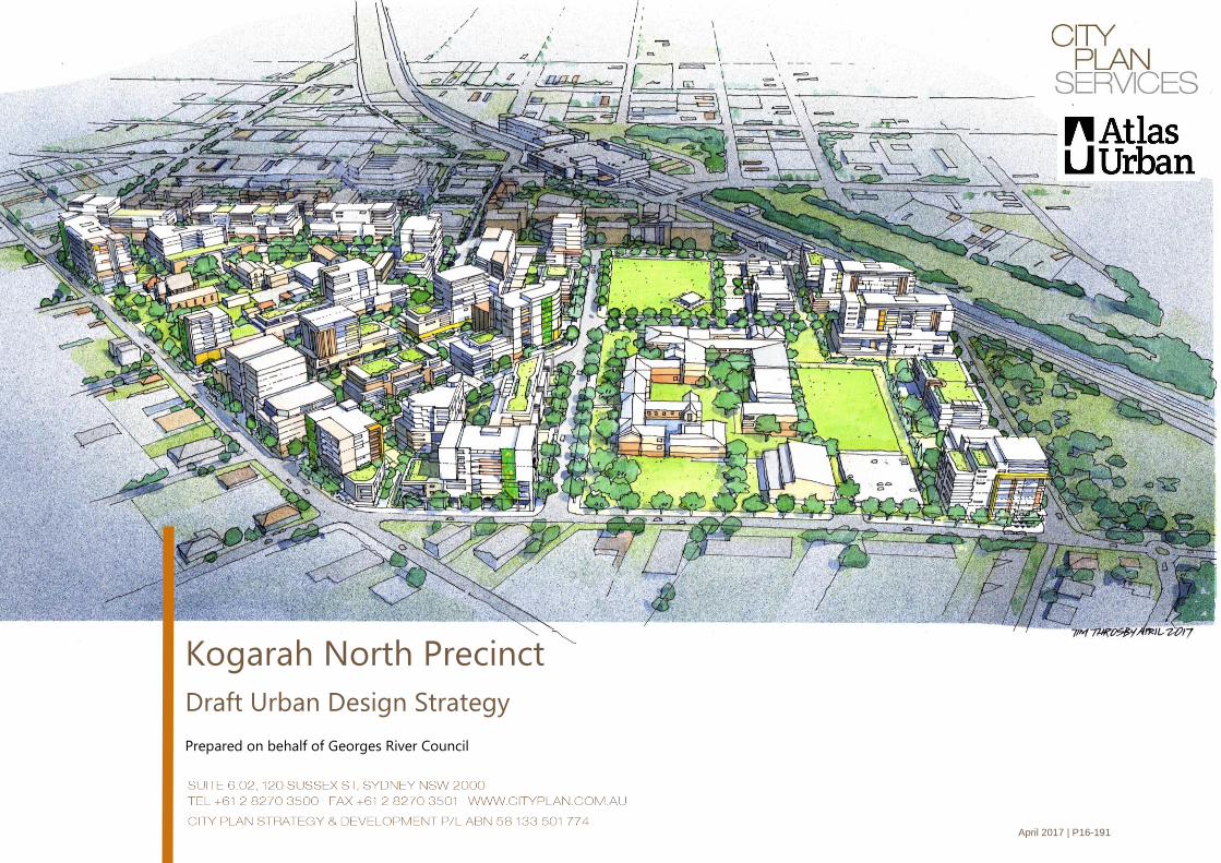
Kogarah North Precinct
Draft Urban Design Strategy
Prepared on behalf of Georges River Council
City Plan Strategy & Development P/L - Kogarah north precinct – DRAFT urban design strategy APRIL 2017 II
Revision Date Issued Prepared by Reviewed by Verified by
01
Preliminary
Draft
23 March 2017 Lotti Wilkinson
Assistant Planner, CPSD
Paul Walter
Architect, Atlas Urban
Juliet Grant
Executive Director, CPSD
Juliet Grant
Executive Director, CPSD
02
Draft for
Council
consideration
18 April 2017 Lotti Wilkinson
Assistant Planner, CPSD
Paul Walter
Architect, Atlas Urban
Juliet Grant
Executive Director, CPSD
Paul Walter
Architect, Atlas Urban
This document is preliminary unless approved by a Director of City Plan Strategy & Development
Report Revision History
CERTIFICATION
This report has been authorised by City Plan Strategy & Development, with input from other expert consultants, on behalf of Georges River Council. The accuracy of the information
contained herein is to the best of our knowledge not false or misleading. The comments have been based upon information and facts that were correct at the time of writing this report.
Copyright © City Plan Strategy & Development P/L
ABN 58 133 501 774
All Rights Reserved. No material may be reproduced without prior permission. While we have tried to ensure the accuracy of the information in this publication, the Publisher accepts no
responsibility or liability for any errors, omissions or resultant consequences including any loss or damage arising from resilience in information in this publication
City Plan Strategy & Development P/L - Kogarah north precinct – DRAFT urban design strategy APRIL 2017 III
Acknowledgements
City Plan Strategy & Development and Atlas Urban Design would like to thank the
following members of our Technical Advisory Group for their advice and input during
the preparation of this draft Urban Design Strategy:
▪ Kevin Driver, Turner Studio http://www.turnerstudio.com.au/
▪ Damion Cavanagh, BMT WBM http://www.bmtwbm.com.au/
▪ Ana Silkatcheva, City Plan Heritage http://www.cityplan.com.au/heritage/
▪ Dr Kam Tara, URaP http://www.urap.com.au/index.html
City Plan Strategy & Development P/L - Kogarah north precinct – DRAFT urban design strategy APRIL 2017 IV
Table of Contents
Acknowledgements ........................................................................................... III
Executive Summary ........................................................................................... VI
1. Setting the Scene ........................................................................................ 1
1.1 The Role of the Urban Design Strategy .........................................................1
1.2 The Kogarah North Precinct ................................................................................1
1.3 Vision ............................................................................................................................3
1.4 Stakeholder Engagement .....................................................................................4
1.5 Key Planning Documents .....................................................................................4
1.5.1 A Plan for Growing Sydney ...............................................................4
1.5.2 Draft South District Plan .....................................................................5
1.5.3 Kogarah 2031 Housing Strategy .....................................................6
1.5.4 Kogarah LEP 2012 .................................................................................6
1.6 Population Growth and Change ........................................................................7
2. Analysis ......................................................................................................... 9
2.1 Constraints and Weaknesses ..............................................................................9
2.2 Strengths and Opportunities ........................................................................... 10
2.3 Strata Properties.................................................................................................... 11
2.4 Heritage .................................................................................................................... 12
2.5 Public Land Ownership ....................................................................................... 13
2.6 Land Form ................................................................................................................ 14
2.7 Road Hierarchy ...................................................................................................... 15
2.8 Public Transport and Pedestrian Links ......................................................... 16
2.9 Stormwater .............................................................................................................. 17
2.10 Open Space and Street Trees .......................................................................... 18
3. Design ......................................................................................................... 19
3.1 Design Investigation ........................................................................................... 19
3.1.1 Option 1 ................................................................................................. 20
3.1.2 Option 2 ................................................................................................. 21
3.1.3 Option 3 ................................................................................................. 22
3.2 Urban Design Principles .................................................................................... 23
3.2.1 Context and Neighbourhood Character .................................. 24
3.2.2 Built Form and Scale ......................................................................... 25
3.2.3 Urban Structure .................................................................................. 28
3.2.4 Density ................................................................................................... 33
3.2.5 Sustainability........................................................................................ 35
3.2.6 Landscape ............................................................................................. 39
3.2.7 Amenity .................................................................................................. 40
3.2.8 Safety ...................................................................................................... 42
3.2.9 Housing Diversity and Social Interaction ................................. 44
3.2.10 Aesthetics .............................................................................................. 45
4. Delivery Framework ................................................................................. 46
4.1 Implementation..................................................................................................... 46
4.1.1 Development Control Plan ............................................................ 46
4.1.2 Planning Proposal.............................................................................. 46
4.1.3 R4 Zoning along Princes Highway Frontage .......................... 46
4.2 Funding Mechanisms.......................................................................................... 46
4.2.1 Section 94 Contributions Plan ...................................................... 46
4.2.2 Voluntary Planning agreements .................................................. 46
4.3 Next Steps ............................................................................................................... 46
City Plan Strategy & Development P/L - Kogarah north precinct – DRAFT urban design strategy APRIL 2017 V
Figures
Figure 1: Site Context - Aerial view of the study area ....................................... 1
Figure 2: A Plan for Growing Sydney ................................................................ 4
Figure 3: Kogarah health and education super precinct - existing activities
(extract from draft South District Plan) ............................................................. 5
Figure 4: Existing Zoning Map under the Kogarah LEP 2012 - Precinct area
outlined in black ............................................................................................... 6
Figure 5: Graph showing the Kogarah Age Groups (2006-2011) (Source: Profile
id (2011)) .......................................................................................................... 7
Figure 6: Group showing the Breakdown of the South District Dwelling Type
(2011) (Source: Department of Planning and Environment (2016)) ................... 7
Figure 7: Employment Sectors in the South District (2011) (Source: Department
of Planning and Environment (2016)) ............................................................... 8
Figure 8: Kogarah Household Type (2006-2011) (Source: Profile.id (2011)) ...... 8
Figure 9: Constraints and Weaknesses Analysis Diagram .................................. 9
Figure 10: Strengths and Opportunities Analysis Diagram .............................. 10
Figure 11: Strata Properties and Pre-Development Applications Analysis
Diagram. ......................................................................................................... 11
Figure 12: Heritage Analysis Diagram ............................................................. 12
Figure 13: Public Land Ownership Analysis Diagram ...................................... 13
Figure 14: Land Form Analysis Diagram .......................................................... 14
Figure 15: Road Hierarchy Analysis Diagram .................................................. 15
Figure 16: Public Transport and Pedestrian Links Analysis Diagram ................ 16
Figure 17: Stormwater Analysis Diagram ........................................................ 17
Figure 18: Open Space & Trees Analysis ......................................................... 18
Figure 19: Aerial View looking east across the study area. .............................. 20
Figure 20: Aerial view looking south across the study area. ........................... 20
Figure 21: View looking north-west across the study area.............................. 20
Figure 22: Aerial view looking east across the study area. .............................. 21
Figure 23: View looking north-west across the study area.............................. 21
Figure 24: Aerial view looking south across the study area. ........................... 21
Figure 25: Aerial view looking south across the study area. ........................... 22
Figure 26: Aerial view looking east across the study area ............................... 22
Figure 27: View looking north-west across the study area ............................. 22
Figure 28: Typical Street Section Diagram ...................................................... 27
Figure 29: Corner Section Diagram................................................................. 27
Figure 30: Princes Highway Section Diagram. ................................................ 27
Figure 31: Street Character Urban Design Diagram ........................................ 29
Figure 32: Access and Movement (Vehicles) Diagram .................................... 30
Figure 33: Access and Movement (Bicycles) Diagram ..................................... 31
Figure 34: Pedestrian Links and Open Space Diagram ................................... 32
Figure 35: Block and Corner Hierarchy Urban Design Diagram ...................... 34
Figure 36: Tree Canopy Diagram .................................................................... 36
Figure 37: Living Architecture Diagram .......................................................... 37
Figure 38: Water Sensitive Urban Design Diagram ......................................... 38
Figure 39: Public Open Space Urban Design Diagram .................................... 41
Figure 40: Active Frontages Urban Design Diagrams ..................................... 43
City Plan Strategy & Development P/L - Kogarah north precinct – DRAFT urban design strategy APRIL 2017 VI
Executive Summary
This draft Urban Design Strategy has been prepared by City Plan Strategy and Development in conjunction with Atlas Urban Design on behalf of
Georges River Council (Council). The Precinct is the subject of a proposed amendment to the Kogarah Local Environmental Plan 2012 (LEP), which will
introduce new planning rules that allow for a greater intensity of residential uses across the Precinct.
The role of this draft Urban Design Strategy is to enable the transformation of the Kogarah North Precinct to occur in a way that maintains a high
quality of amenity for the existing residents (through the transition) and future residents. The draft Urban Design Strategy has been informed by an in-
depth urban design and planning analysis and a series of place based considerations, which include:
▪ Vehicular Transport and Access Analysis;
▪ Active and Public Transport Analysis;
▪ Landscape Characteristic Analysis;
▪ Heritage Items Analysis;
▪ Land Ownership Analysis; and
▪ Strata Property Analysis
The draft Urban Design Strategy provides recommendations to allow Council to determine a preferred urban design and planning response for the
future redevelopment of the Kogarah North Precinct. The draft Urban Design Strategy identifies appropriate planning and urban design principles and
strategies to encourage the creation of a higher density residential Precinct that supports an appropriate scale and density of development, traffic and
pedestrian management, landscaping and other public domain improvements. The provisions within the Apartment Design Guide (NSW Department
of Planning and Environment 2016) underpin the principles set out within this draft Strategy.
An amendment to the Kogarah Section 94A Contributions Plan for the Kogarah North Precinct (2014) has been prepared to accompany this draft Urban
Design Strategy.
CITY PLAN STRATEGY & DEVELOPMENT P/L - KOGARAH NORTH PRECINCT – DRAFT URBAN DESIGN STRATEGY APRIL 2017
1/46
1. Setting the Scene
1.1 The Role of the Urban Design Strategy
This draft Urban Design Strategy has been prepared by City Plan
Strategy and Development in conjunction with Atlas Urban Design on
behalf of Georges River Council (Council). The Precinct is the subject of
a proposed amendment to the Kogarah Local Environmental Plan 2012
(KLEP), which will introduce new height and floorspace ratio controls
that allow for a greater intensity of residential uses across the Precinct.
The purpose of this draft Urban Design Strategy is to facilitate renewal
and redevelopment within the Precinct in a coordinated way.
This draft Urban Design Strategy forms the basis for future local
planning and plan-making within the Precinct. This Strategy is intended
to:
1. Assist in decision making in regard to Development Applications
(DA) submitted when the New City Plan is gazetted; and
2. Inform further strategic planning for the Precinct including
preparation of a Precinct-wide Development Control Plan (DCP),
and possibly further amendments to the KLEP.
A Section 94 Contributions Plan for the Kogarah North Precinct has been
prepared separately to apportion costs as it arises from development.
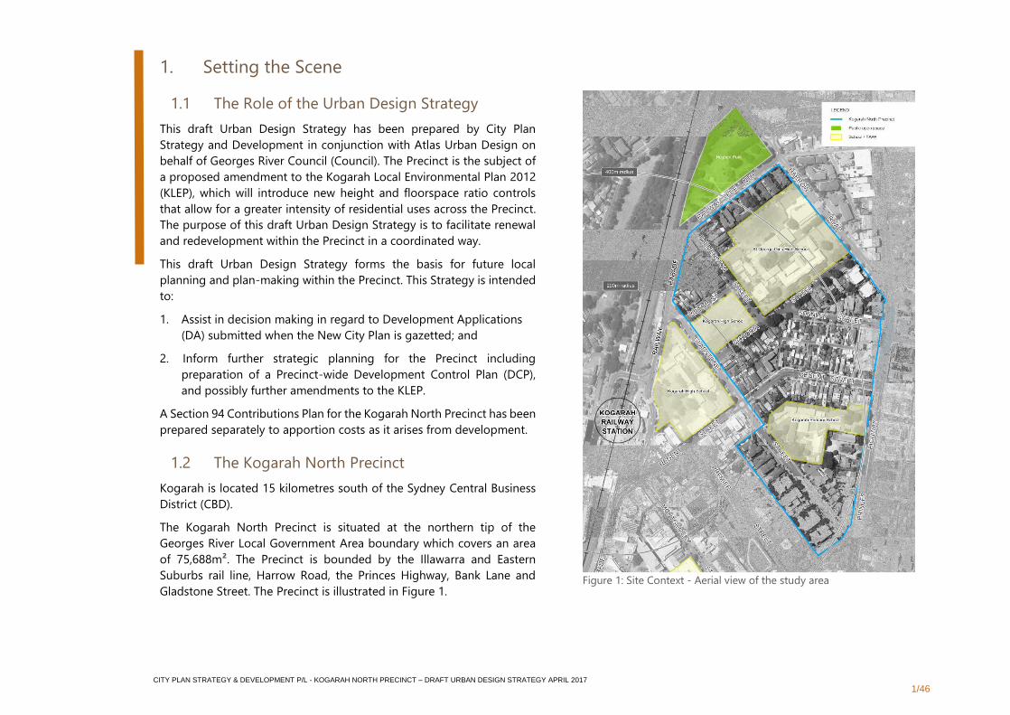
1.2 The Kogarah North Precinct
Kogarah is located 15 kilometres south of the Sydney Central Business
District (CBD).
The Kogarah North Precinct is situated at the northern tip of the
Georges River Local Government Area boundary which covers an area
of 75,688m². The Precinct is bounded by the Illawarra and Eastern
Suburbs rail line, Harrow Road, the Princes Highway, Bank Lane and
Gladstone Street. The Precinct is illustrated in Figure 1.
Figure 1: Site Context - Aerial view of the study area
CITY PLAN STRATEGY & DEVELOPMENT P/L - KOGARAH NORTH PRECINCT – DRAFT URBAN DESIGN STRATEGY APRIL 2017
2/46
The Kogarah North Precinct sits to the north of Kogarah Town Centre,
an area which has undergone a significant transformation over the last
decade, to become a vibrant, liveable and working community. Kogarah
is a highly concentrated business district, with two major hospitals (St
George Public and St George Private Hospitals) and the second largest
TAFE in New South Wales (NSW).
Due to the extent of development over the last 10-15 years and the lack
of land zoned to accommodate future growth of the Centre, the existing
Kogarah Town Centre has become constrained. In order to provide
additional housing opportunities close to the Kogarah Town Centre, the
Kogarah North Precinct was identified as a suitable location to
accommodate growth.
The proposed New City Plan (amendment to the KLEP) will enable a
greater intensity of residential uses across the Precinct and gives effect
to broader metropolitan-wide directions to support urban
consolidation, particularly in locations close to jobs and public transport
services. The Precinct's location makes it an excellent candidate in this
regard. The draft South District Plan (NSW Government, November
2016) highlights the importance of the broader area as the District's
main job-generators, and hence its "health and education super
Precinct" (Figure 2).
"Kogarah provides a mix of retail and commercial activity. It is
home to St George Hospital and several other health
industries. As of 2016, over 50% of jobs were generated in the
health care and social assistance sectors. Other major
activities relate to the finance and insurance industry largely
on account of the St George Bank headquarters in the area."
- Kogarah Employment Profile, draft South District Plan
CITY PLAN STRATEGY & DEVELOPMENT P/L - KOGARAH NORTH PRECINCT – DRAFT URBAN DESIGN STRATEGY APRIL 2017
3/46
1.3 Vision
The Kogarah North Precinct is characterised by low-scale residential
streets of mid-century one and two storey red brick houses, and semis.
Three schools make public areas a focus for children and families living
nearby and further afield. Domestic life is played out in front and rear
yards and in relatively large homes, with room for extended family
visits, entertaining guests, children’s play, gardening, keeping pets and
so on.
The coming change to the Precinct will see a shift from low density
residential to higher density apartment buildings. The change in the
local character and increase in population will see the area transform,
providing an array of opportunities to the current and future
population. New residents will live at higher densities and in apartment
buildings. Consequently, public and communal spaces will play a far
greater role as places for entertaining, socialising, exercise and all kinds
of recreation.
These factors all point to the importance of providing quality public
space and community facilities within the Precinct. This relates to the
qualities of particular places, such as parks and streets. It also relates
to the range of activities that are possible, such as kicking a ball, sitting
quietly, having a picnic, walking a dog, tending a garden. These
elements are shaped by the structure of the Precinct, and the variety of
ways people can move through the area.
The height and FSR controls proposed in the New City Plan enable 10-
storey built forms, representing a significant change in the scale and
character of the Precinct. This draft Strategy seeks to maintain the
human scale and build on the Precinct’s existing character to deliver a
vision that is relevant to its current and future communities.
Kogarah North offers high density living within an excellent
public domain. A variety of apartments help to build a community
made up of many kinds of households. Importantly, this enables
people to pass through life's different stages while remaining
within the neighbourhood. The convenience of having work,
services, entertainment and the station nearby mean people
rarely need a car to meet their daily needs, or to access the rest
of Sydney. The area's leafy streets, beautiful public and hidden
parks, community facilities and visible heritage features make for
an attractive, people-friendly environment. There are many
pleasant places to stop awhile and chat to neighbours, providing
the setting for a rich and varied community life
The vision for Kogarah North is supported by four keystone urban design
and development principles to:
1. Retain, embellish and connect existing green and
community assets;
2. Create secondary routes that prioritise connections for
walkers and cyclists;
3. Maintain the human-scale at street level; and
4. Declutter the public realm.
These keystone principles have emerged through detailed urban design
analysis of the Precinct. They set the framework for establishing Precinct-
wide design and development parameters and guidelines, and considering
specific considerations for individual blocks or smaller areas within the
Precinct.
CITY PLAN STRATEGY & DEVELOPMENT P/L - KOGARAH NORTH PRECINCT – DRAFT URBAN DESIGN STRATEGY APRIL 2017
4/46
1.4 Stakeholder Engagement
The draft Urban Design Strategy was prepared in consultation with
key key stakeholders within the Precinct including Georges River
Council, offices and landowners.
A Stakeholder Engagement Report has been prepared, which
provides a summary of the stakeholder engagement that occurred
and the key issues and opportunities that arose through the
process. Further stakeholder engagement will be undertaken by
Council during exhibition of the draft Strategy.
1.5 Key Planning Documents
A range of contemporary strategic planning policy documents
identify Kogarah as a significant and growing employment hub
offering a range of jobs and services, largely in the health and
education sectors, and an important centre for retail and
commercial activity. The need to provide a mix of housing
opportunities close by to jobs and public transport services is
recognised as being fundamental for the continued growth of
Kogarah.
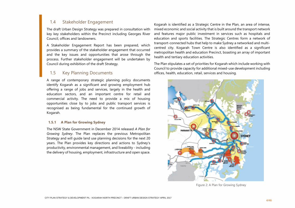
1.5.1 A Plan for Growing Sydney
The NSW State Government in December 2014 released A Plan for
Growing Sydney. The Plan replaces the previous Metropolitan
Strategy and will guide land use planning decisions for the next 20
years. The Plan provides key directions and actions to Sydney's
productivity, environmental management, and liveability - including
the delivery of housing, employment, infrastructure and open space.
Kogarah is identified as a Strategic Centre in the Plan, an area of intense,
mixed economic and social activity that is built around the transport network
and features major public investment in services such as hospitals and
education and sports facilities. The Strategic Centres form a network of
transport-connected hubs that help to make Sydney a networked and multi-
centred city. Kogarah Town Centre is also identified as a significant
metropolitan health and education Precinct, boasting an array of important
health and tertiary education activities.
The Plan stipulates a set of priorities for Kogarah which include working with
Council to provide capacity for additional mixed-use development including
offices, health, education, retail, services and housing.
Figure 2: A Plan for Growing Sydney
CITY PLAN STRATEGY & DEVELOPMENT P/L - KOGARAH NORTH PRECINCT – DRAFT URBAN DESIGN STRATEGY APRIL 2017
5/46
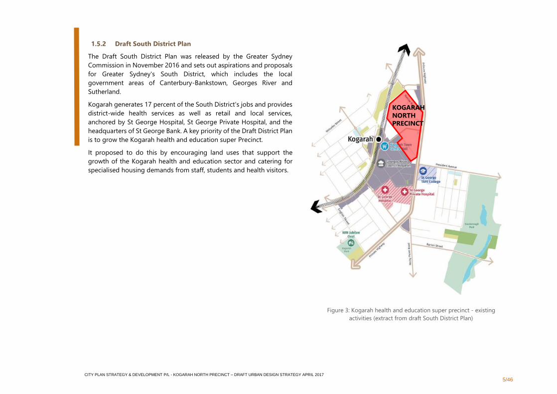
1.5.2 Draft South District Plan
The Draft South District Plan was released by the Greater Sydney
Commission in November 2016 and sets out aspirations and proposals
for Greater Sydney's South District, which includes the local
government areas of Canterbury-Bankstown, Georges River and
Sutherland.
Kogarah generates 17 percent of the South District's jobs and provides
district-wide health services as well as retail and local services,
anchored by St George Hospital, St George Private Hospital, and the
headquarters of St George Bank. A key priority of the Draft District Plan
is to grow the Kogarah health and education super Precinct.
It proposed to do this by encouraging land uses that support the
growth of the Kogarah health and education sector and catering for
specialised housing demands from staff, students and health visitors.
Figure 3: Kogarah health and education super precinct - existing
activities (extract from draft South District Plan)
KOGARAH
NORTH
PRECINCT
CITY PLAN STRATEGY & DEVELOPMENT P/L - KOGARAH NORTH PRECINCT – DRAFT URBAN DESIGN STRATEGY APRIL 2017
6/46
1.5.3 Kogarah 2031 Housing Strategy
Kogarah has an ageing population while at the same time is
experiencing growth in new families. Providing housing to suit the
needs of the population as they move through different life stages is
essential. This includes opportunities for young people and young
families to set up their own homes in the area, and for older residents
to downsize to smaller dwellings. Even without any increase in
population there would still be demand for new housing as peoples’
housing needs change over time, with children leaving home and
wanting to stay locally or parents wishing to down size and still be
close to longstanding friends and family.
The five key objectives of the Kogarah 2031 Housing Strategy are:
1. Housing across the City of Kogarah designed so that it
provides choice, is affordable and is suited to the needs of
our community.
2. Local centres within the City of Kogarah are distinctive
and vibrant, providing opportunities for small businesses to
flourish throughout the city.
3 Kogarah City residents can get to where they need to go
in a way that is accessible, safe and efficient.
4. Development in Kogarah maintains and enhances the
character and amenity of our neighbourhoods, town centres
and local centres.
5. Comply with State Government requirements for housing
targets throughout the Sydney Metropolitan Area.
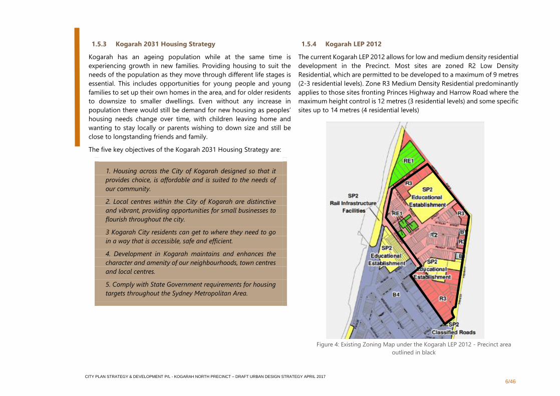
1.5.4 Kogarah LEP 2012
The current Kogarah LEP 2012 allows for low and medium density residential
development in the Precinct. Most sites are zoned R2 Low Density
Residential, which are permitted to be developed to a maximum of 9 metres
(2-3 residential levels). Zone R3 Medium Density Residential predominantly
applies to those sites fronting Princes Highway and Harrow Road where the
maximum height control is 12 metres (3 residential levels) and some specific
sites up to 14 metres (4 residential levels)
Figure 4: Existing Zoning Map under the Kogarah LEP 2012 - Precinct area
outlined in black

CITY PLAN STRATEGY & DEVELOPMENT P/L - KOGARAH NORTH PRECINCT – DRAFT URBAN DESIGN STRATEGY APRIL 2017
7/46
1.6 Population Growth and Change
In 2011 the South District, comprising the Local Government Areas
(LGA) of Canterbury, Bankstown, Georges River and Sutherland,
was home to approximately 610,550 people. Household numbers
within the South District are expected to increase to 284,900 by
2031, triggering demand for an increase of 62,800 dwellings from
2011. Within the District the population of over-65s is predicted to
grow by 56,000 people by 2031, prompting the need for
appropriate housing choices.
Within the South District the breakdown of dwellings types in 2011
comprised 56% separate houses, 36% flats, units or apartments
and 8% semi-detached. However, since 2011 there has been a clear
trend towards the construction of multi-unit dwellings rather than
detached houses. Of the recent increase in dwelling stock, 60% has
been the construction of apartments and nearly 40% of these new
apartments comprise households with children. The trend towards
apartment living is occurring at the District level, with increasing
approvals for and the construction of multi-dwelling apartments,
while there is a shift towards smaller households. This matches the
changes occurring in Greater Sydney with 50% of residents either
owning or renting an apartment.
The increasing ageing population within the South District calls for
increased apartment supply, with 38% of baby boomers intending
on moving from a larger house to a smaller apartment (Urban
Taskforce 2015). Similarly, there is a need for more affordable
housing options to cater for young families and individuals.
Currently the 25-35 age bracket accounts for 39% of apartment
renters.
0200400600800
100012001400
0-4 5-11 12-17 18-24 25-34 35-49 50-59 60-69 70-84 85andover
Pers
on
s
Age Groups
Kogarah Age Groups (2006-2011)
2006 2011
Separate House, 56%
Semi-detached,
8%
Flat, Unit or Apartment ,
36%
South District Dwelling Type (2011)
Figure 5: Graph showing the Kogarah Age Groups (2006-2011) (Source: Profile
id (2011))
Figure 6: Group showing the Breakdown of the South District Dwelling Type
(2011) (Source: Department of Planning and Environment (2016))
CITY PLAN STRATEGY & DEVELOPMENT P/L - KOGARAH NORTH PRECINCT – DRAFT URBAN DESIGN STRATEGY APRIL 2017
8/46
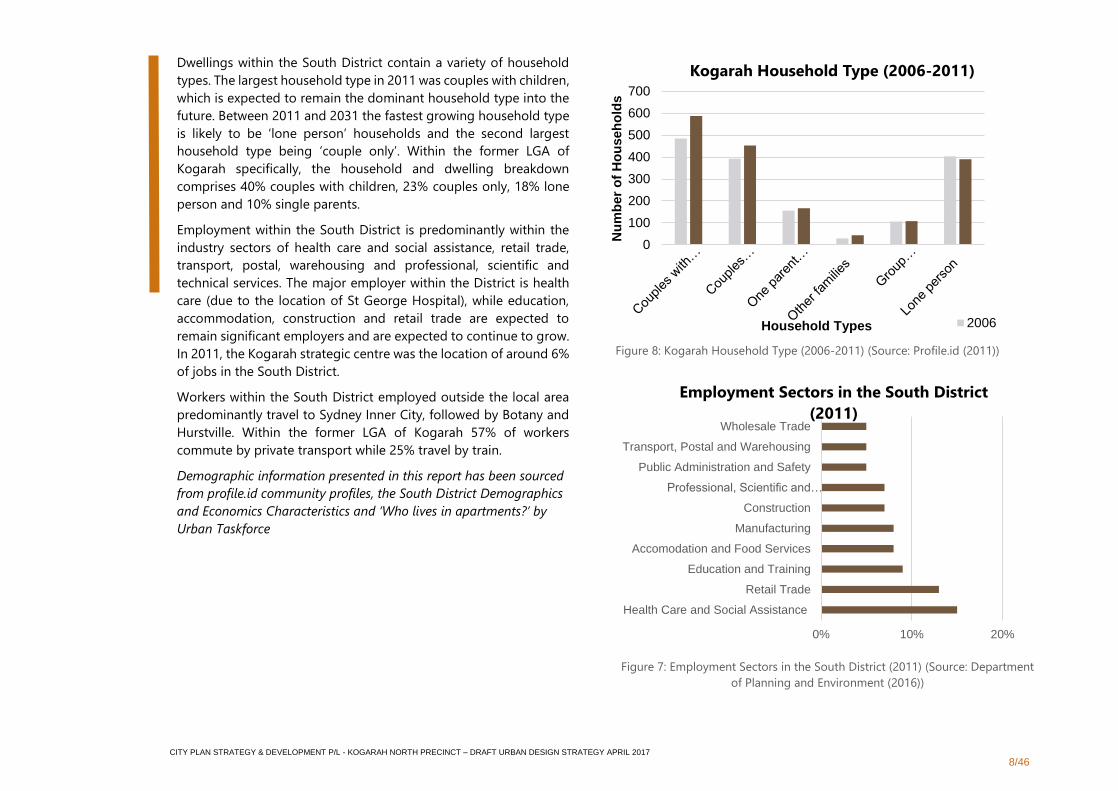
Dwellings within the South District contain a variety of household
types. The largest household type in 2011 was couples with children,
which is expected to remain the dominant household type into the
future. Between 2011 and 2031 the fastest growing household type
is likely to be ‘lone person’ households and the second largest
household type being ‘couple only’. Within the former LGA of
Kogarah specifically, the household and dwelling breakdown
comprises 40% couples with children, 23% couples only, 18% lone
person and 10% single parents.
Employment within the South District is predominantly within the
industry sectors of health care and social assistance, retail trade,
transport, postal, warehousing and professional, scientific and
technical services. The major employer within the District is health
care (due to the location of St George Hospital), while education,
accommodation, construction and retail trade are expected to
remain significant employers and are expected to continue to grow.
In 2011, the Kogarah strategic centre was the location of around 6%
of jobs in the South District.
Workers within the South District employed outside the local area
predominantly travel to Sydney Inner City, followed by Botany and
Hurstville. Within the former LGA of Kogarah 57% of workers
commute by private transport while 25% travel by train.
Demographic information presented in this report has been sourced
from profile.id community profiles, the South District Demographics
and Economics Characteristics and ‘Who lives in apartments?’ by
Urban Taskforce
0
100
200
300
400
500
600
700
Nu
mb
er
of
Ho
useh
old
s
Household Types
Kogarah Household Type (2006-2011)
2006
0% 10% 20%
Health Care and Social Assistance
Retail Trade
Education and Training
Accomodation and Food Services
Manufacturing
Construction
Professional, Scientific and…
Public Administration and Safety
Transport, Postal and Warehousing
Wholesale Trade
Employment Sectors in the South District
(2011)
Figure 8: Kogarah Household Type (2006-2011) (Source: Profile.id (2011))
Figure 7: Employment Sectors in the South District (2011) (Source: Department
of Planning and Environment (2016))
CITY PLAN STRATEGY & DEVELOPMENT P/L - KOGARAH NORTH PRECINCT – DRAFT URBAN DESIGN STRATEGY APRIL 2017
9/46
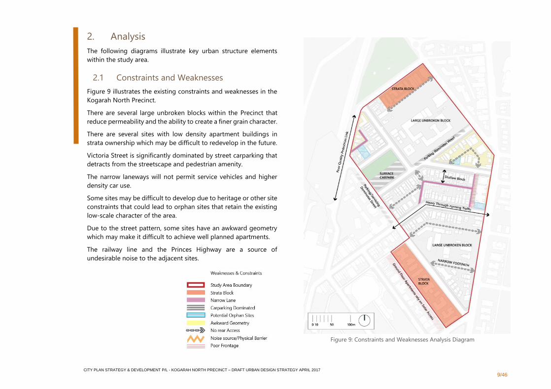
2. Analysis
The following diagrams illustrate key urban structure elements
within the study area.
2.1 Constraints and Weaknesses
Figure 9 illustrates the existing constraints and weaknesses in the
Kogarah North Precinct.
There are several large unbroken blocks within the Precinct that
reduce permeability and the ability to create a finer grain character.
There are several sites with low density apartment buildings in
strata ownership which may be difficult to redevelop in the future.
Victoria Street is significantly dominated by street carparking that
detracts from the streetscape and pedestrian amenity.
The narrow laneways will not permit service vehicles and higher
density car use.
Some sites may be difficult to develop due to heritage or other site
constraints that could lead to orphan sites that retain the existing
low-scale character of the area.
Due to the street pattern, some sites have an awkward geometry
which may make it difficult to achieve well planned apartments.
The railway line and the Princes Highway are a source of
undesirable noise to the adjacent sites.
Figure 9: Constraints and Weaknesses Analysis Diagram
CITY PLAN STRATEGY & DEVELOPMENT P/L - KOGARAH NORTH PRECINCT – DRAFT URBAN DESIGN STRATEGY APRIL 2017
10/46
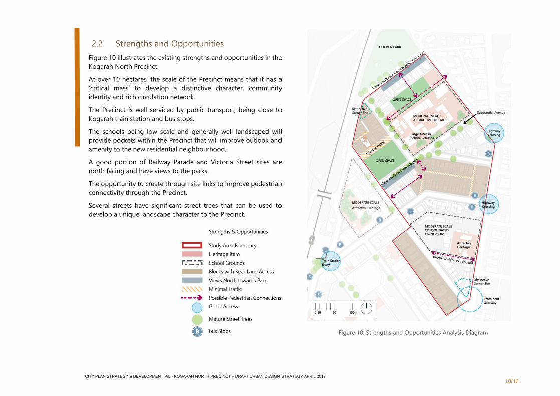
2.2 Strengths and Opportunities
Figure 10 illustrates the existing strengths and opportunities in the
Kogarah North Precinct.
At over 10 hectares, the scale of the Precinct means that it has a
‘critical mass’ to develop a distinctive character, community
identity and rich circulation network.
The Precinct is well serviced by public transport, being close to
Kogarah train station and bus stops.
The schools being low scale and generally well landscaped will
provide pockets within the Precinct that will improve outlook and
amenity to the new residential neighbourhood.
A good portion of Railway Parade and Victoria Street sites are
north facing and have views to the parks.
The opportunity to create through site links to improve pedestrian
connectivity through the Precinct.
Several streets have significant street trees that can be used to
develop a unique landscape character to the Precinct.
Figure 10: Strengths and Opportunities Analysis Diagram
CITY PLAN STRATEGY & DEVELOPMENT P/L - KOGARAH NORTH PRECINCT – DRAFT URBAN DESIGN STRATEGY APRIL 2017
11/46
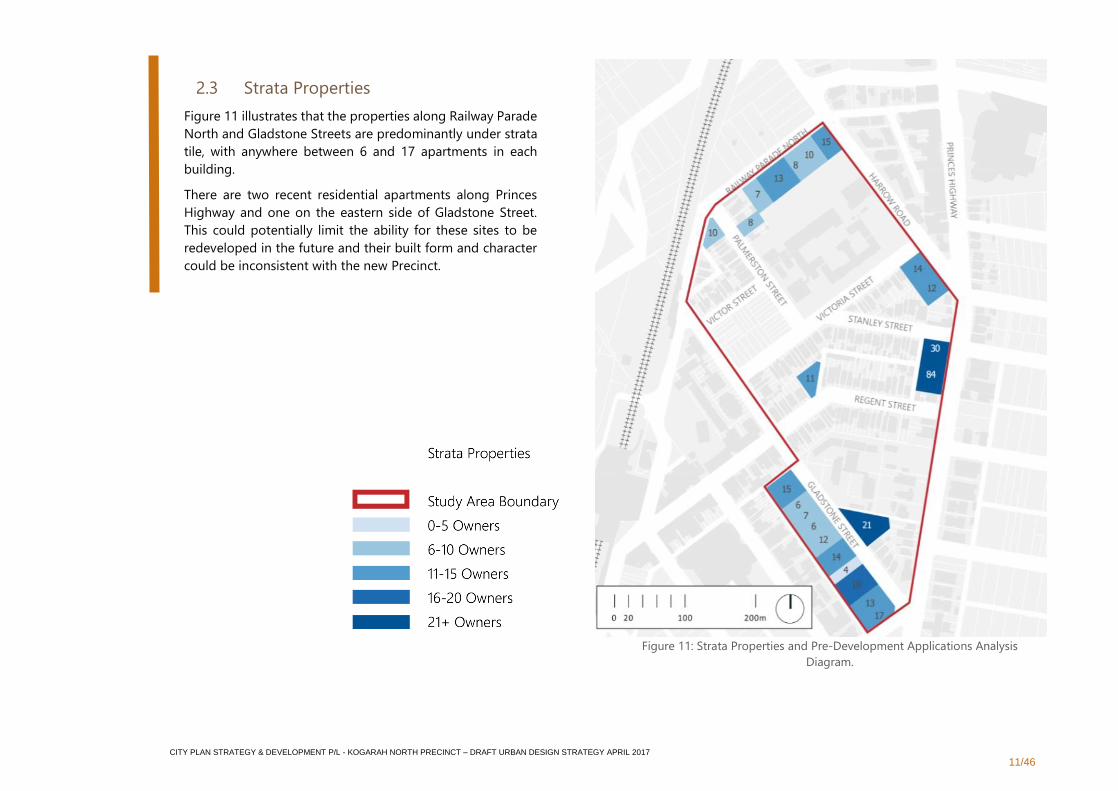
2.3 Strata Properties
Figure 11 illustrates that the properties along Railway Parade
North and Gladstone Streets are predominantly under strata
tile, with anywhere between 6 and 17 apartments in each
building.
There are two recent residential apartments along Princes
Highway and one on the eastern side of Gladstone Street.
This could potentially limit the ability for these sites to be
redeveloped in the future and their built form and character
could be inconsistent with the new Precinct.
Figure 11: Strata Properties and Pre-Development Applications Analysis
Diagram.
CITY PLAN STRATEGY & DEVELOPMENT P/L - KOGARAH NORTH PRECINCT – DRAFT URBAN DESIGN STRATEGY APRIL 2017
12/46
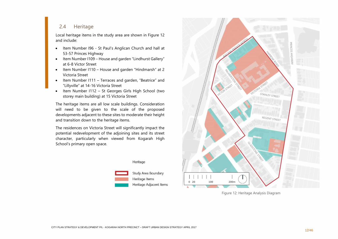
2.4 Heritage
Local heritage items in the study area are shown in Figure 12
and include:
• Item Number I96 - St Paul’s Anglican Church and hall at
53-57 Princes Highway
• Item Number I109 – House and garden “Lindhurst Gallery”
at 6-8 Victor Street
• Item Number I110 – House and garden “Hindmarsh” at 2
Victoria Street
• Item Number I111 – Terraces and garden, “Beatrice” and
“Lillyville” at 14-16 Victoria Street
• Item Number I112 – St Georges Girls High School (two
storey main building) at 15 Victoria Street
The heritage items are all low scale buildings. Consideration
will need to be given to the scale of the proposed
developments adjacent to these sites to moderate their height
and transition down to the heritage items.
The residences on Victoria Street will significantly impact the
potential redevelopment of the adjoining sites and its street
character, particularly when viewed from Kogarah High
School’s primary open space.
Figure 12: Heritage Analysis Diagram
CITY PLAN STRATEGY & DEVELOPMENT P/L - KOGARAH NORTH PRECINCT – DRAFT URBAN DESIGN STRATEGY APRIL 2017
13/46
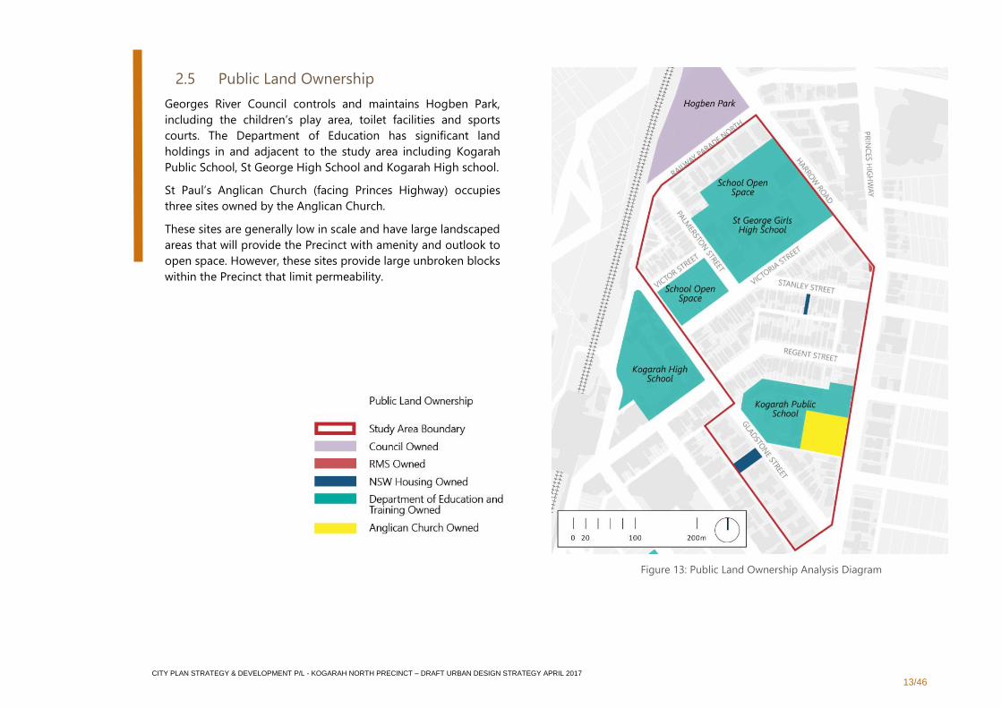
2.5 Public Land Ownership
Georges River Council controls and maintains Hogben Park,
including the children’s play area, toilet facilities and sports
courts. The Department of Education has significant land
holdings in and adjacent to the study area including Kogarah
Public School, St George High School and Kogarah High school.
St Paul’s Anglican Church (facing Princes Highway) occupies
three sites owned by the Anglican Church.
These sites are generally low in scale and have large landscaped
areas that will provide the Precinct with amenity and outlook to
open space. However, these sites provide large unbroken blocks
within the Precinct that limit permeability.
Figure 13: Public Land Ownership Analysis Diagram
CITY PLAN STRATEGY & DEVELOPMENT P/L - KOGARAH NORTH PRECINCT – DRAFT URBAN DESIGN STRATEGY APRIL 2017
14/46
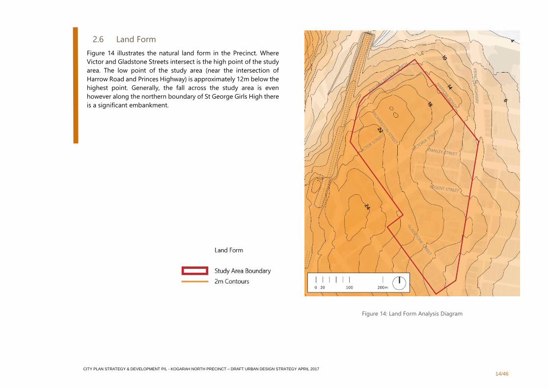
2.6 Land Form
Figure 14 illustrates the natural land form in the Precinct. Where
Victor and Gladstone Streets intersect is the high point of the study
area. The low point of the study area (near the intersection of
Harrow Road and Princes Highway) is approximately 12m below the
highest point. Generally, the fall across the study area is even
however along the northern boundary of St George Girls High there
is a significant embankment.
Figure 14: Land Form Analysis Diagram
CITY PLAN STRATEGY & DEVELOPMENT P/L - KOGARAH NORTH PRECINCT – DRAFT URBAN DESIGN STRATEGY APRIL 2017
15/46
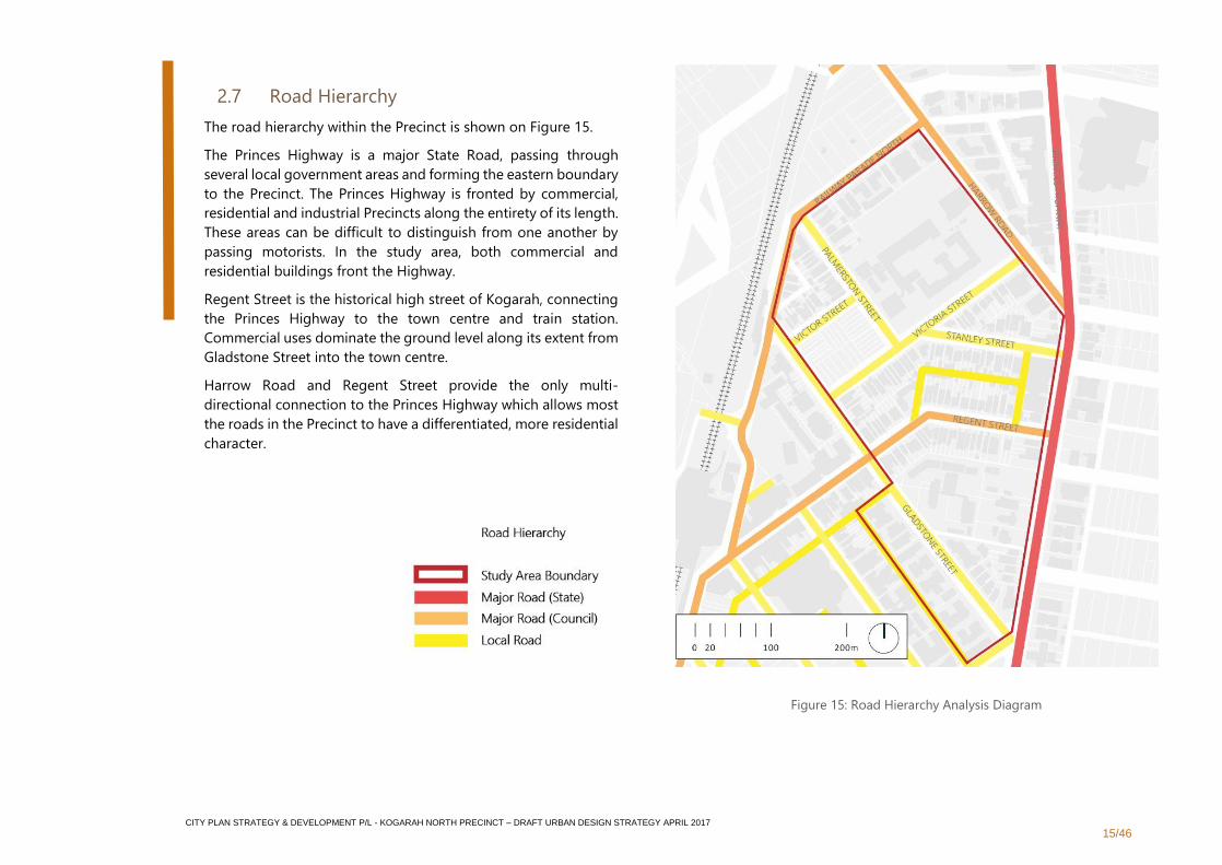
2.7 Road Hierarchy
The road hierarchy within the Precinct is shown on Figure 15.
The Princes Highway is a major State Road, passing through
several local government areas and forming the eastern boundary
to the Precinct. The Princes Highway is fronted by commercial,
residential and industrial Precincts along the entirety of its length.
These areas can be difficult to distinguish from one another by
passing motorists. In the study area, both commercial and
residential buildings front the Highway.
Regent Street is the historical high street of Kogarah, connecting
the Princes Highway to the town centre and train station.
Commercial uses dominate the ground level along its extent from
Gladstone Street into the town centre.
Harrow Road and Regent Street provide the only multi-
directional connection to the Princes Highway which allows most
the roads in the Precinct to have a differentiated, more residential
character.
Figure 15: Road Hierarchy Analysis Diagram
CITY PLAN STRATEGY & DEVELOPMENT P/L - KOGARAH NORTH PRECINCT – DRAFT URBAN DESIGN STRATEGY APRIL 2017
16/46
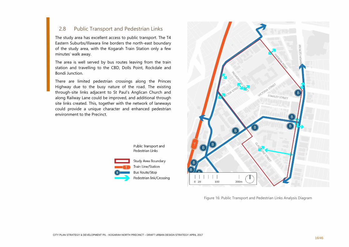
2.8 Public Transport and Pedestrian Links
The study area has excellent access to public transport. The T4
Eastern Suburbs/Illawara line borders the north-east boundary
of the study area, with the Kogarah Train Station only a few
minutes’ walk away.
The area is well served by bus routes leaving from the train
station and travelling to the CBD, Dolls Point, Rockdale and
Bondi Junction.
There are limited pedestrian crossings along the Princes
Highway due to the busy nature of the road. The existing
through-site links adjacent to St Paul’s Anglican Church and
along Railway Lane could be improved, and additional through
site links created. This, together with the network of laneways
could provide a unique character and enhanced pedestrian
environment to the Precinct.
Figure 16: Public Transport and Pedestrian Links Analysis Diagram
CITY PLAN STRATEGY & DEVELOPMENT P/L - KOGARAH NORTH PRECINCT – DRAFT URBAN DESIGN STRATEGY APRIL 2017
17/46
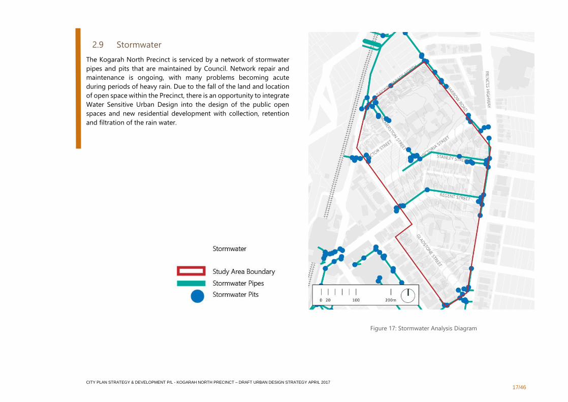
2.9 Stormwater
The Kogarah North Precinct is serviced by a network of stormwater
pipes and pits that are maintained by Council. Network repair and
maintenance is ongoing, with many problems becoming acute
during periods of heavy rain. Due to the fall of the land and location
of open space within the Precinct, there is an opportunity to integrate
Water Sensitive Urban Design into the design of the public open
spaces and new residential development with collection, retention
and filtration of the rain water.
Figure 17: Stormwater Analysis Diagram
CITY PLAN STRATEGY & DEVELOPMENT P/L - KOGARAH NORTH PRECINCT – DRAFT URBAN DESIGN STRATEGY APRIL 2017
18/46
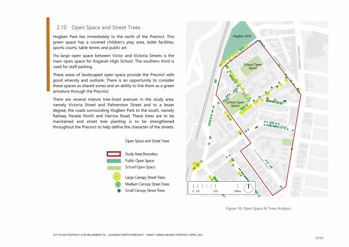
2.10 Open Space and Street Trees
Hogben Park lies immediately to the north of the Precinct. This
green space has a covered children’s play area, toilet facilities,
sports courts, table tennis and public art.
The large open space between Victor and Victoria Streets is the
main open space for Kogarah High School. The southern third is
used for staff parking.
These areas of landscaped open space provide the Precinct with
good amenity and outlook. There is an opportunity to consider
these spaces as shared zones and an ability to link them as a green
armature through the Precinct.
There are several mature tree-lined avenues in the study area,
namely Victoria Street and Palmerston Street and to a lesser
degree, the roads surrounding Hogben Park to the south, namely
Railway Parade North and Harrow Road. These trees are to be
maintained and street tree planting is to be strengthened
throughout the Precinct to help define the character of the streets.
Source
Figure 18: Open Space & Trees Analysis
CITY PLAN STRATEGY & DEVELOPMENT P/L - KOGARAH NORTH PRECINCT – DRAFT URBAN DESIGN STRATEGY APRIL 2017
19/46
3. Design
3.1 Design Investigation
A three dimensional (3D) model of the Precinct was created
utilising a range of development control assumptions including:
the proposed 33m height controls; retention of the local heritage
items; and varying degrees of compliance with the Apartment
Design Guide* (ADG).
Three potential options were generated:
▪ Option 1 provides a FSR of 4:1 and a Gross Floor Area** of
264,804sqm.
▪ Option 2 provides a FSR of 2.75:1 and a Gross Floor Area**
of 181,947 sqm.
▪ Option 3 provides a FSR of 2.52:1 and a Gross Floor Area**
of 166,690 sqm.
Option 3 was selected as the preferred option upon which to base
the draft Strategy. It should be noted that this massing option
forms one option that responds to the urban design principles.
Different massing options could arise depending on lot
amalgamations and staging.
*It is not possible to fully test the ADG compliance of the
proposed envelopes. Options 2 and 3 comply with the
requirements for solar access, cross ventilation and building
separation.
**Gross Floor Area calculation is based on 72% efficiency from
Gross Building Area to Gross Floor Area.
CITY PLAN STRATEGY & DEVELOPMENT P/L - KOGARAH NORTH PRECINCT – DRAFT URBAN DESIGN STRATEGY APRIL 2017
20/46
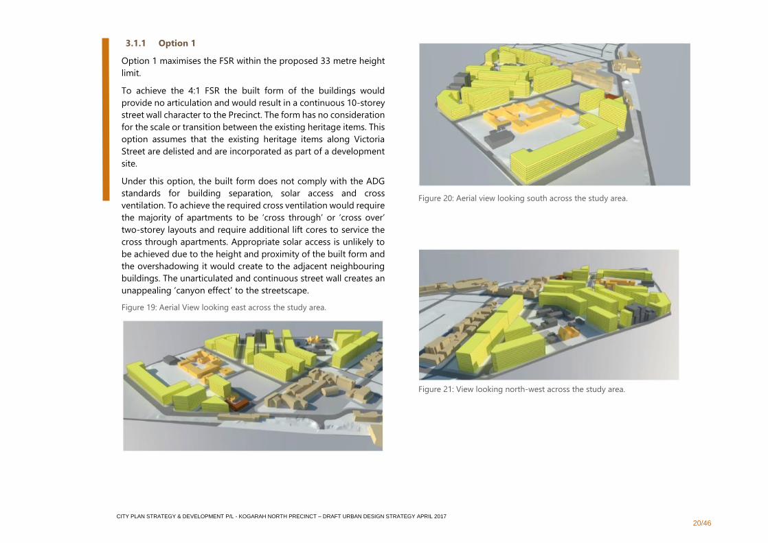
3.1.1 Option 1
Option 1 maximises the FSR within the proposed 33 metre height
limit.
To achieve the 4:1 FSR the built form of the buildings would
provide no articulation and would result in a continuous 10-storey
street wall character to the Precinct. The form has no consideration
for the scale or transition between the existing heritage items. This
option assumes that the existing heritage items along Victoria
Street are delisted and are incorporated as part of a development
site.
Under this option, the built form does not comply with the ADG
standards for building separation, solar access and cross
ventilation. To achieve the required cross ventilation would require
the majority of apartments to be ‘cross through’ or ‘cross over’
two-storey layouts and require additional lift cores to service the
cross through apartments. Appropriate solar access is unlikely to
be achieved due to the height and proximity of the built form and
the overshadowing it would create to the adjacent neighbouring
buildings. The unarticulated and continuous street wall creates an
unappealing ‘canyon effect’ to the streetscape.
Figure 19: Aerial View looking east across the study area.
Figure 20: Aerial view looking south across the study area.
Figure 21: View looking north-west across the study area.
CITY PLAN STRATEGY & DEVELOPMENT P/L - KOGARAH NORTH PRECINCT – DRAFT URBAN DESIGN STRATEGY APRIL 2017
21/46
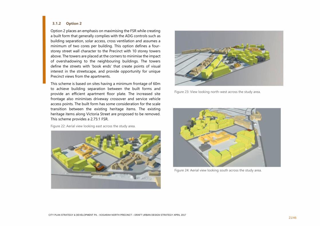
3.1.2 Option 2
Option 2 places an emphasis on maximising the FSR while creating
a built form that generally complies with the ADG controls such as
building separation, solar access, cross ventilation and assumes a
minimum of two cores per building. This option defines a four-
storey street wall character to the Precinct with 10 storey towers
above. The towers are placed at the corners to minimise the impact
of overshadowing to the neighbouring buildings. The towers
define the streets with ‘book ends’ that create points of visual
interest in the streetscape, and provide opportunity for unique
Precinct views from the apartments.
This scheme is based on sites having a minimum frontage of 60m
to achieve building separation between the built forms and
provide an efficient apartment floor plate. The increased site
frontage also minimises driveway crossover and service vehicle
access points. The built form has some consideration for the scale
transition between the existing heritage items. The existing
heritage items along Victoria Street are proposed to be removed.
This scheme provides a 2.75:1 FSR.
Figure 22: Aerial view looking east across the study area.
Figure 23: View looking north-west across the study area.
Figure 24: Aerial view looking south across the study area.
CITY PLAN STRATEGY & DEVELOPMENT P/L - KOGARAH NORTH PRECINCT – DRAFT URBAN DESIGN STRATEGY APRIL 2017
22/46
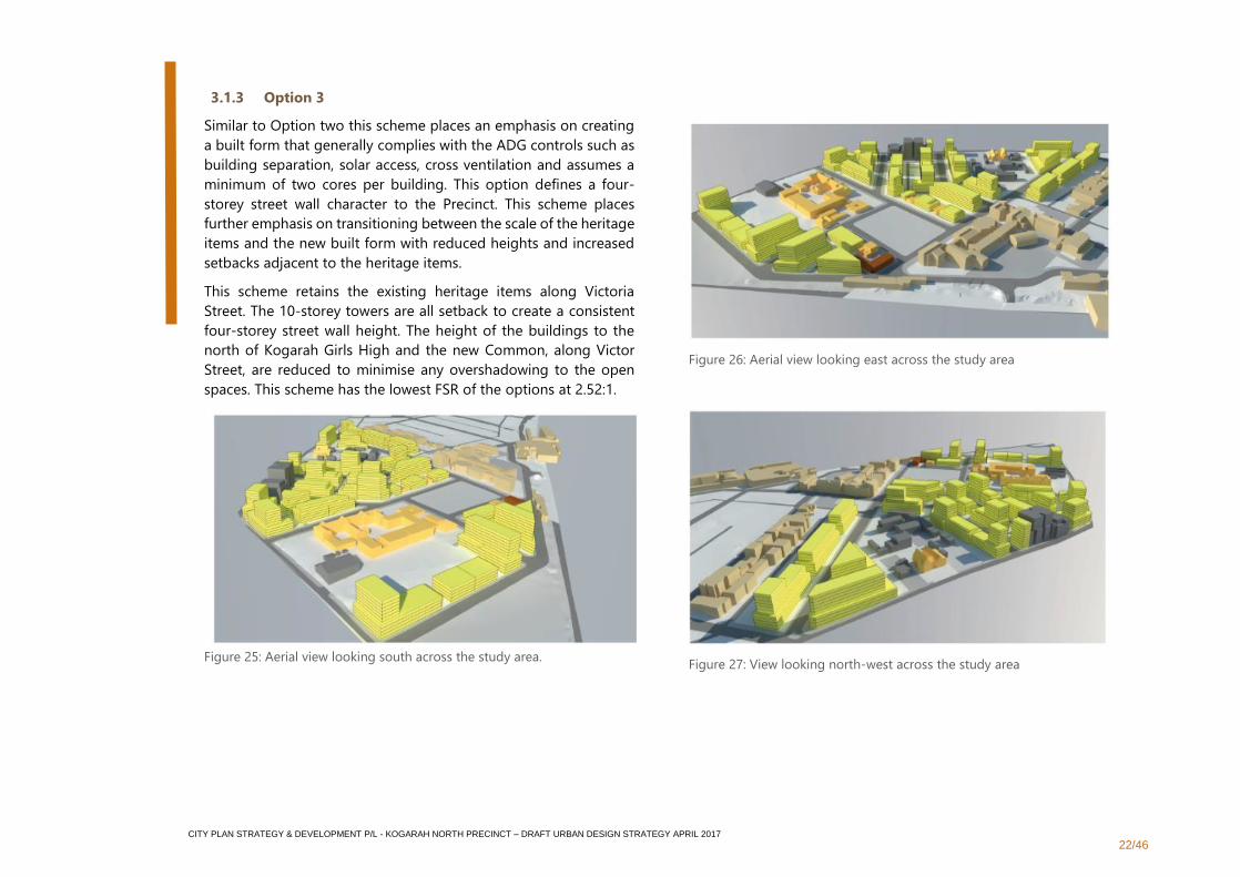
3.1.3 Option 3
Similar to Option two this scheme places an emphasis on creating
a built form that generally complies with the ADG controls such as
building separation, solar access, cross ventilation and assumes a
minimum of two cores per building. This option defines a four-
storey street wall character to the Precinct. This scheme places
further emphasis on transitioning between the scale of the heritage
items and the new built form with reduced heights and increased
setbacks adjacent to the heritage items.
This scheme retains the existing heritage items along Victoria
Street. The 10-storey towers are all setback to create a consistent
four-storey street wall height. The height of the buildings to the
north of Kogarah Girls High and the new Common, along Victor
Street, are reduced to minimise any overshadowing to the open
spaces. This scheme has the lowest FSR of the options at 2.52:1.
Figure 25: Aerial view looking south across the study area.
Figure 26: Aerial view looking east across the study area
Figure 27: View looking north-west across the study area
CITY PLAN STRATEGY & DEVELOPMENT P/L - KOGARAH NORTH PRECINCT – DRAFT URBAN DESIGN STRATEGY APRIL 2017
23/46
3.2 Urban Design Principles
The following urban design principles have been informed by
urban design and planning analysis of the Kogarah North
Precinct. The principles identify appropriate planning and urban
design measures to encourage the renewal of land to a higher
residential Precinct and address the scale and density of
development, traffic and pedestrian management, landscaping
and other public domain improvements.
In addition to compliance with the provisions contained within
the Apartment Design Guide, future development proposals
within the Kogarah North Precinct are encouraged to comply
with these urban design principles.
CITY PLAN STRATEGY & DEVELOPMENT P/L - KOGARAH NORTH PRECINCT – DRAFT URBAN DESIGN STRATEGY APRIL 2017
24/46
3.2.1 Context and Neighbourhood Character
Objectives
▪ To recognise that the Precinct character will undergo a radical transformation as development intensifies in coming years
▪ To acknowledge and strengthen the key character elements that will remain including the primary urban structure, heritage items and
institutional land uses
▪ To retain all heritage buildings across the Precinct and encourage their preservation
Strategies
▪ Step-down the building scale adjacent to heritage items
▪ Provide adequate curtilage and setbacks to heritage items
▪ Maintain solar access to existing apartment buildings and public open space
▪ Protect the large established avenue trees, particularly in Victoria Street and Palmerston Street
▪ Follow the Australia ICOMOS Charter for Places of Cultural Significance, The Burra Charter for development to heritage items
CITY PLAN STRATEGY & DEVELOPMENT P/L - KOGARAH NORTH PRECINCT – DRAFT URBAN DESIGN STRATEGY APRIL 2017
25/46
3.2.2 Built Form and Scale
Objectives
▪ To ensure a comfortable human scale, avoiding the appearance of deep and unbroken canyons and tempering the scale of the street-edge
buildings
▪ To create buildings that define the streets and parks, with a consistent pattern of massing while fostering architectural diversity within this
framework, thereby encouraging different streets to have a distinct and recognisable character
▪ To encourage heritage conservation
▪ To ensure that development does not result in the creation of isolated sites
▪ To encourage site consolidation for efficiency and improved public domain interface
Strategies
▪ Amalgamation of allotments will be required in the circumstance where an isolated allotment would otherwise be created
▪ Encourage lot consolidation to create a 60m street frontage length to optimise yield and public domain amenity
▪ Predominant streetscape of four storeys in the foreground (suggest 5m front setback), with taller elements set behind this (8m upper setback)
▪ Consider the possibility for smaller or zero street setbacks on super-block corners and corners with neighbourhood shop ground floor uses
▪ Secondary corners with neighbourhood shops at ground floor are to provide a 2m setback to the street wall, while residential use at the ground
floor will require a 5m setback to the street wall
▪ Zero side setbacks are permitted up to four storeys if the building is compliant with the ADG and if the building maintains neighbouring sites’
redevelopment potential. Zero side setbacks are not permitted if the building is adjacent to a heritage item
▪ The maximum length of a building above the four storey podium is 40 metres
▪ Neighbourhood shops to the ground floor are to extend for a maximum of 20m past the corner
▪ Taller building elements to be separated with breaks in massing to allow views beyond, sky and sunlight
▪ No ground floor apartments are to be below the adjacent footpath level
▪ Avoid ziggurat building form (prefer one step not two above podium level)
▪ Minimise ‘dead’ frontage to streets and maximise the use of active frontages
▪ Provide adequate curtilage and side setbacks from heritage sites and a transition in height from the heritage items

CITY PLAN STRATEGY & DEVELOPMENT P/L - KOGARAH NORTH PRECINCT – DRAFT URBAN DESIGN STRATEGY APRIL 2017
26/46
▪ Council may consider the use of a transferable Heritage Floor Space Scheme
▪ Buildings to the south of St Paul’s Anglican Church to have a 15-metre setback from the church site
▪ Princes Highway frontage setback to be similar to the adjacent frontage along the highway
▪ Investigate mechanisms for subsequent integration of isolated sites such as shared basement connections and servicing
CITY PLAN STRATEGY & DEVELOPMENT P/L - KOGARAH NORTH PRECINCT – DRAFT URBAN DESIGN STRATEGY APRIL 2017
27/46
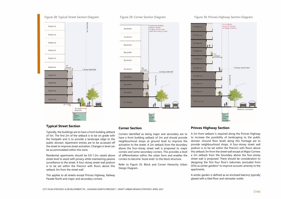
Typical Street Section
Typically, the buildings are to have a front building setback
of 5m. The first 2m of the setback is to be on grade with
the footpath and is to provide a landscape edge to the
public domain. Apartment entries are to be accessed off
the street to improve street activation. Changes in level can
be accommodated within this zone.
Residential apartments should be 0.9-1.2m raised above
street level to assist with privacy while maintaining passive
surveillance to the street. A four-storey street wall podium
is to be set within the Precinct with floors above this
setback 3m from the street wall.
This applies to all streets except Princes Highway, Railway
Parade North and major and secondary corners.
Corner Section
Corners identified as being major and secondary are to
have a front building setback of 2m and should provide
neighbourhood shops at ground level to improve the
activation to the street. A 2m setback from the boundary
above the four-storey street wall is proposed to major
corners and some secondary corners. This provides a level
of differentiation within the urban form and enables the
corners to become ‘book ends’ to the block structure.
Refer to Figure 35: Block and Corner Hierarchy Urban
Design Diagram.
Princes Highway Section
A 2m front setback is required along the Princes Highway
to increase the possibility of landscaping to the public
domain. Ground floor levels along this frontage are to
provide neighbourhood shops. A four-storey street wall
podium is to be set within the Precinct with floors above
this setback 3m from the street wall except at Major Corners
a 2m setback from the boundary above the four-storey
street wall is proposed. There should be consideration to
designing the first four floor’s balconies (excluded from
GFA) as winter gardens* to improve acoustic amenity to the
apartments.
A winter garden is defined as an enclosed balcony typically
glazed with a tiled floor and rainwater outlet.
Figure 28: Typical Street Section Diagram Figure 29: Corner Section Diagram. Figure 30: Princes Highway Section Diagram.
CITY PLAN STRATEGY & DEVELOPMENT P/L - KOGARAH NORTH PRECINCT – DRAFT URBAN DESIGN STRATEGY APRIL 2017
28/46
3.2.3 Urban Structure
Objectives
▪ To recognise that as the function of the Precinct changes, its structure should be adapted and modified to respond to the new set of uses. As
density increases, the urban block structure should become finer and permeability and intersection density should increase
▪ To support the predominance of walking as the way of moving through the neighbourhood
▪ To provide a set of new open spaces in the neighbourhood to serve a variety of recreational and social functions
▪ To create a clear hierarchy to the streets and laneways, while providing a consistent character throughout the Precinct.
▪ To provide pedestrian linkages and access routes though the Precinct to offer residents and visitors greater choice of movement, as well as a
safer and more enjoyable walking or cycling experience
Strategies
▪ Create new links and laneways to increase permeability of movement within the Precinct and increase pedestrian intersection density through
the neighbourhood
▪ Ensure open spaces are easily reachable with connections to the surroundings
▪ Design open spaces that contribute to the positive effects of being within Sydney’s green grid and a green infrastructure network
▪ Ensure that urban structure and open spaces respond to the objectives for Water Sensitive Urban Design Spaces and stormwater management,
through elements such as drainage swales and detention ponds
▪ Create a new shared zone to Railway Lane running north south
▪ Create a new shared zone on Victor Street as an extension to the Town Common
▪ Create a new through site link from Railway Lane to Palmerston Street (suggest through 11 Palmerston Street)
▪ Create a new laneway north south through Block 2 as a continuation of Regent Lane
▪ Create a new through site link from Stanley Lane to Victoria Street (suggest through 22 Victoria Street)
▪ Widen existing through site link south of St Paul’s Anglican Church to 10m
▪ Investigate the use of Kogarah High School’s primary open space to become a shared space – Town Common
▪ Investigate creating a small-scale carpark under part of the Town Common to house carparking for Kogarah High School and the public
▪ Consider opportunities to encourage a change in land use to adaptively reuse 12 and 14 Victor Street for a community facility
CITY PLAN STRATEGY & DEVELOPMENT P/L - KOGARAH NORTH PRECINCT – DRAFT URBAN DESIGN STRATEGY APRIL 2017
29/46
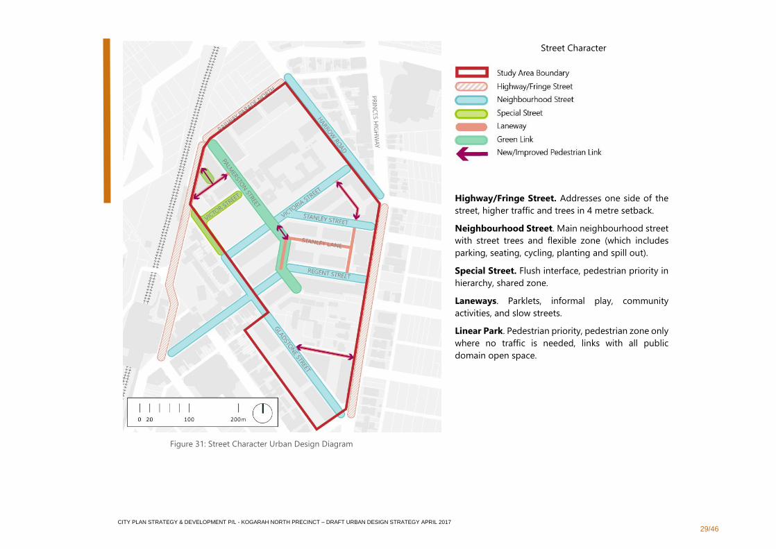
Street Character
Highway/Fringe Street. Addresses one side of the
street, higher traffic and trees in 4 metre setback.
Neighbourhood Street. Main neighbourhood street
with street trees and flexible zone (which includes
parking, seating, cycling, planting and spill out).
Special Street. Flush interface, pedestrian priority in
hierarchy, shared zone.
Laneways. Parklets, informal play, community
activities, and slow streets.
Linear Park. Pedestrian priority, pedestrian zone only
where no traffic is needed, links with all public
domain open space.
Figure 31: Street Character Urban Design Diagram
CITY PLAN STRATEGY & DEVELOPMENT P/L - KOGARAH NORTH PRECINCT – DRAFT URBAN DESIGN STRATEGY APRIL 2017
30/46
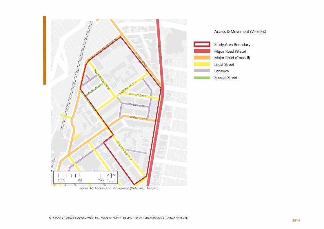
Figure 32: Access and Movement (Vehicles) Diagram
CITY PLAN STRATEGY & DEVELOPMENT P/L - KOGARAH NORTH PRECINCT – DRAFT URBAN DESIGN STRATEGY APRIL 2017
31/46
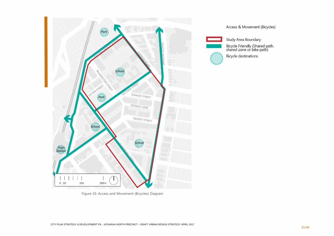
Figure 33: Access and Movement (Bicycles) Diagram
CITY PLAN STRATEGY & DEVELOPMENT P/L - KOGARAH NORTH PRECINCT – DRAFT URBAN DESIGN STRATEGY APRIL 2017
32/46
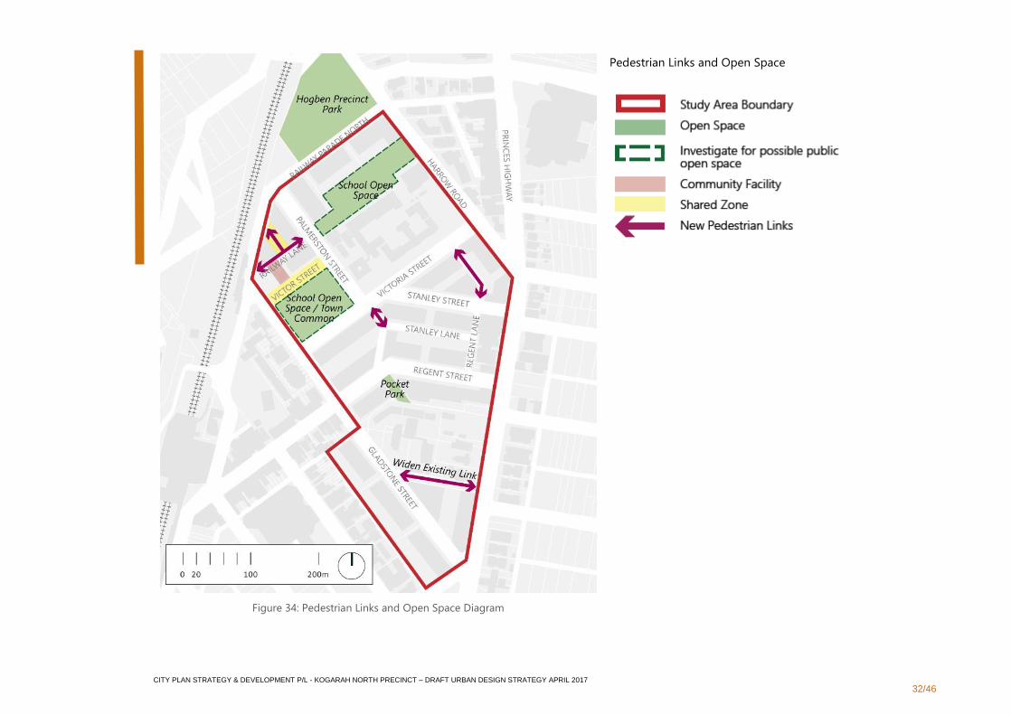
Figure 34: Pedestrian Links and Open Space Diagram
Pedestrian Links and Open Space
CITY PLAN STRATEGY & DEVELOPMENT P/L - KOGARAH NORTH PRECINCT – DRAFT URBAN DESIGN STRATEGY APRIL 2017
33/46
3.2.4 Density
Objectives
▪ To ensure that development maximises density while balancing external impacts, including: impacts on the amenity and development potential
of adjacent development sites; amenity in the public domain; and the need for improvements in infrastructure
▪ To moderate density on constrained sites and permit greater density on sites that have greater capacity and minimal external impacts
Strategies
▪ Permit reduced setbacks at major and some secondary corners for greater yield
▪ Permit zero side boundary setbacks up to 4 storeys to sites along the Princes Highway. Other sites within the Precinct could be considered
dependant on amalgamation patterns, compliance with SEPP 65 solar access and cross ventilation, and demonstration that there would be no
additional impacts to the adjacent properties
▪ Consider schematic design for redevelopment of neighbouring sites to protect Precinct-wide yield density while meeting the provisions set out
within the Apartment Design Guide
CITY PLAN STRATEGY & DEVELOPMENT P/L - KOGARAH NORTH PRECINCT – DRAFT URBAN DESIGN STRATEGY APRIL 2017
34/46
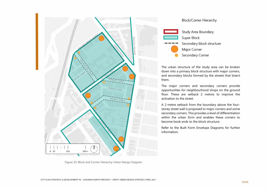
The urban structure of the study area can be broken
down into a primary block structure with major corners,
and secondary blocks formed by the streets that bisect
them.
The major corners and secondary corners provide
opportunities for neighbourhood shops on the ground
floor. These are setback 2 metres to improve the
activation to the street.
A 2-metre setback from the boundary above the four-
storey street wall is proposed to major corners and some
secondary corners. This provides a level of differentiation
within the urban form and enables these corners to
become book ends to the block structure.
Refer to the Built Form Envelope Diagrams for further
information.
Figure 35: Block and Corner Hierarchy Urban Design Diagram
CITY PLAN STRATEGY & DEVELOPMENT P/L - KOGARAH NORTH PRECINCT – DRAFT URBAN DESIGN STRATEGY APRIL 2017
35/46
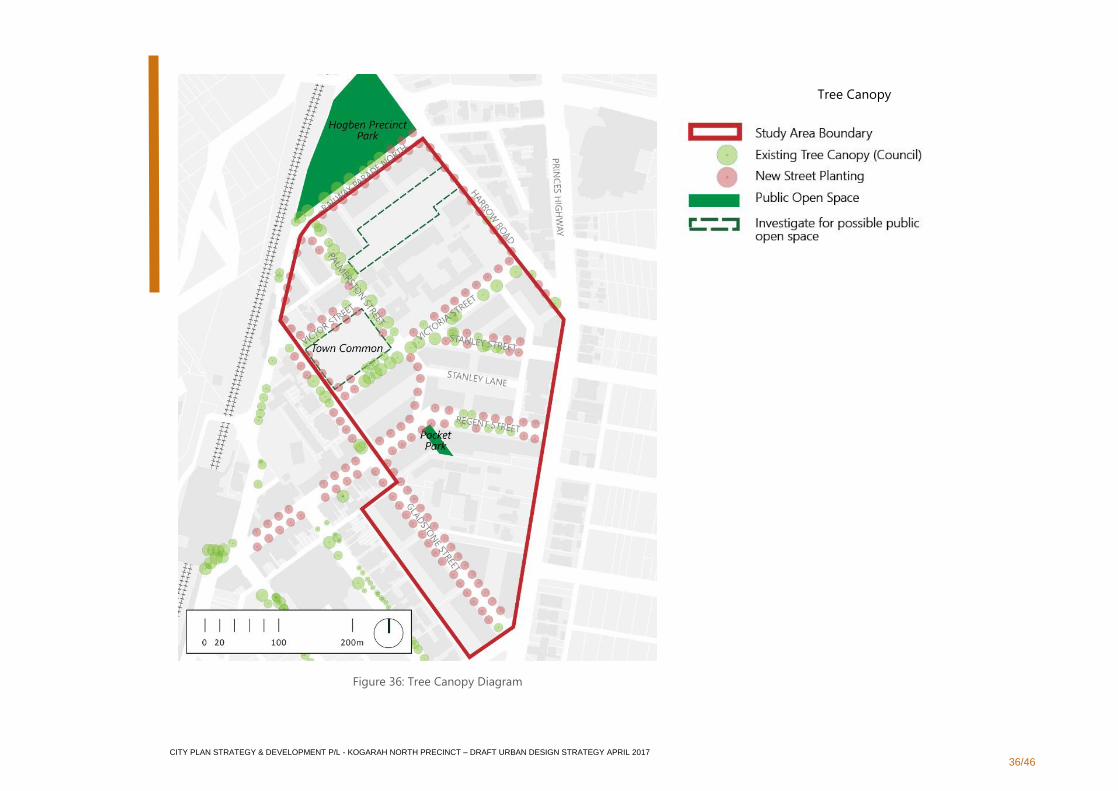
3.2.5 Sustainability
Objectives
▪ To encourage design for sustainable environmental, social and economic outcomes by encouraging designs that minimise usage of power and
water and allow for flexibility in design so that places and facilities may have multiple uses over time; applying the principle of “long-life loose-
fit”
▪ No increase in stormwater beyond the existing output
Strategies
▪ Protect existing trees and plan for street trees to improve micro-climate
▪ Increase tree canopy cover from current 21% of land area to 35% of land area over the entire Precinct area
▪ Encourage green roofs and green walls to improve amenity for the residents, and provide urban markers within the Precinct. Green walls may
include climbers or trees in planter boxes
▪ The encouraged minimum green roof cover per site is 50% and is to be considered as communal open space. Where possible, green cover is to
be located on lower level roofs to improve outlook
▪ Integrate green infrastructure into the streetscape where appropriate
▪ Incorporate a system of Water Sensitive Urban Design, tree canopy cover, living architecture objectives and urban food initiatives
▪ Provide significant tree planting in deep soil for urban canopy objectives and to provide urban ecological habitats
▪ Design for pedestrian priority throughout the Precinct by encouraging walking and public transport usage
▪ Design for a link between green spaces to improve biodiversity across the Precinct and connect to external Green Grid links
▪ All waste collection and service vehicles to be provided for on site
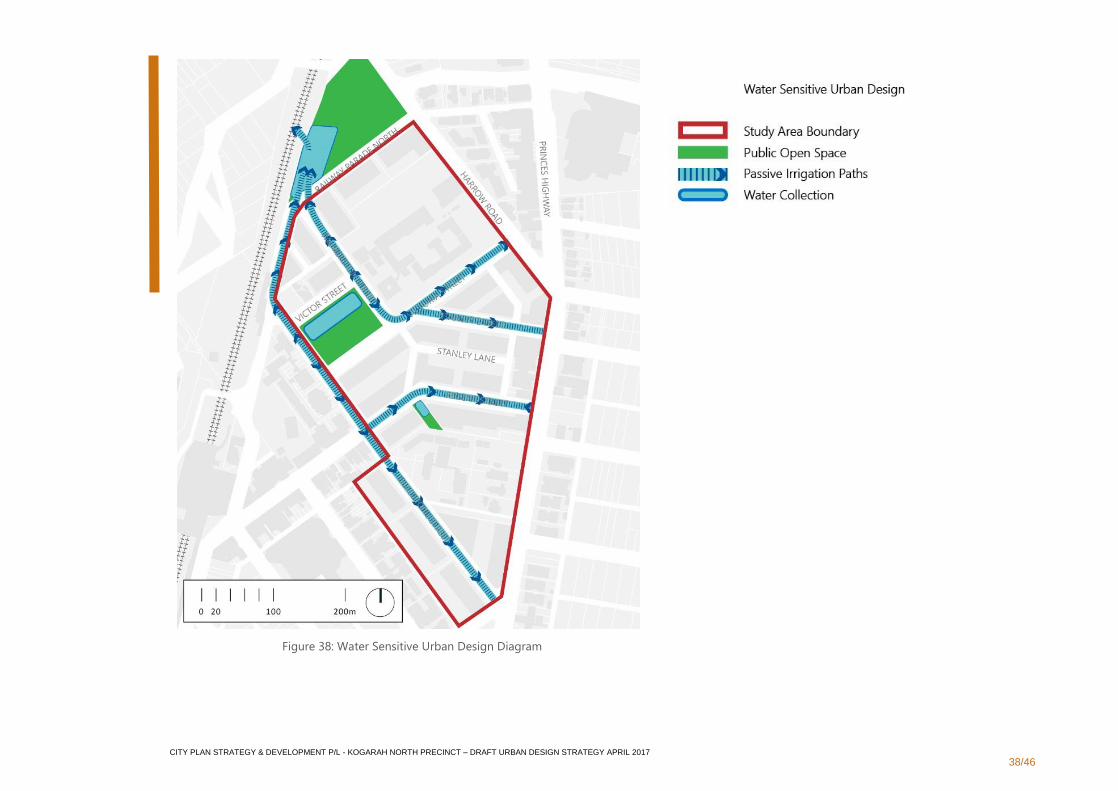
▪ Integrate WSUD including on-site reuse and recycling into the design of the public open spaces with collection, retention and filtration of the
rain water
CITY PLAN STRATEGY & DEVELOPMENT P/L - KOGARAH NORTH PRECINCT – DRAFT URBAN DESIGN STRATEGY APRIL 2017
36/46
Tree Canopy
Figure 36: Tree Canopy Diagram
CITY PLAN STRATEGY & DEVELOPMENT P/L - KOGARAH NORTH PRECINCT – DRAFT URBAN DESIGN STRATEGY APRIL 2017
37/46
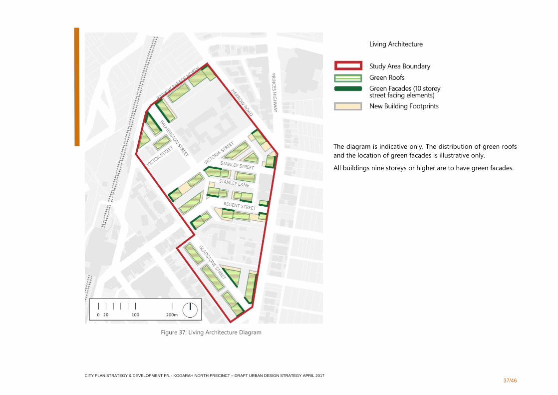
The diagram is indicative only. The distribution of green roofs
and the location of green facades is illustrative only.
All buildings nine storeys or higher are to have green facades.
Figure 37: Living Architecture Diagram
CITY PLAN STRATEGY & DEVELOPMENT P/L - KOGARAH NORTH PRECINCT – DRAFT URBAN DESIGN STRATEGY APRIL 2017
38/46
Figure 38: Water Sensitive Urban Design Diagram
CITY PLAN STRATEGY & DEVELOPMENT P/L - KOGARAH NORTH PRECINCT – DRAFT URBAN DESIGN STRATEGY APRIL 2017
39/46
3.2.6 Landscape
Objectives
▪ To adopt an integrated approach towards landscape in the public and private domain to develop a positive image and contextual fit of well-
designed developments
▪ To recognise that streets serve a far wider set of social and practical needs than previously, because people will be living at higher densities in
apartments without yards or large living rooms
Strategies
▪ To create liveable street designs that are accessible to all and are envisioned as ‘shared spaces’ for both vehicular, pedestrian and cyclist uses,
that are all safe, well connected and activated to promote social activities
▪ Generate a clear hierarchy of high quality streets for ease of legibility and use
▪ Provide a variety of scale and type of public open space
▪ Design visually attractive streetscapes, to foster social well-being and create a comfortable micro-climate
▪ To maintain all significant existing street trees
▪ Provide additional street tree planting in all streets
▪ Create and utilise a detailed material palette of ground surface treatments, public domain furniture and signage strategy for the whole public
domain of the Precinct
▪ Seek opportunities for rear lanes to be configured as shared zones and for adjacent development sites to include community gardens and
community facilities
▪ Utilise ‘Living Architecture’ controls particularly for taller buildings that will have immediate regional views for urban greenery and building
performance
▪ Create a good mix between constant resident related functions and temporary alternative functions of evenings and weekends
▪ Development which is adjacent to open spaces is to enhance its quality by creating compatible activating uses
▪ Development which is adjacent to open spaces is to avoid adverse impacts on open spaces such as overshadowing
CITY PLAN STRATEGY & DEVELOPMENT P/L - KOGARAH NORTH PRECINCT – DRAFT URBAN DESIGN STRATEGY APRIL 2017
40/46
3.2.7 Amenity
Objectives
▪ Encourage social and community interaction in a distinctive and attractive neighbourhood with excellent amenities in public domain
▪ Preserve significant elements that enhance the existing amenity such as large trees and heritage buildings
▪ Create a pleasant leafy environment with a comfortable microclimate shade and sunlight throughout the year
▪ Create a convenient and pleasant walking environment through the neighbourhood
Strategies
▪ Increase the effective amount of public open space in the Precinct by improving the school playing fields and making them available to the
wider community outside of school hours
▪ Seek to establish a community centre with a variety of community functions and possibly including a café at Victor Street and the proposed
Town Common
▪ At Victor Street and the proposed Town Common, provide public amenities such as toilets, cafes and community hubs relating to the proposed
outdoor activities
▪ Create and protect solar access plane to Victor Street to minimise overshadowing to Kogarah High School’s primary open space
▪ Provide a lower built form to Railway Parade to minimise overshadowing to St George Girls High School’s primary open space. Provide solar
access to at least 60% of the playing field at 3pm on June 21st. Demonstrate how the remaining sites along Railway Parade can be development
to a similar density while achieving the solar access requirements.
▪ Maintain solar access to existing apartment buildings and public open space
▪ Maintain a minimum of two hours of solar access to 70% of neighbouring apartments’ private open space and habitable rooms between 9am-
3pm on 21 June
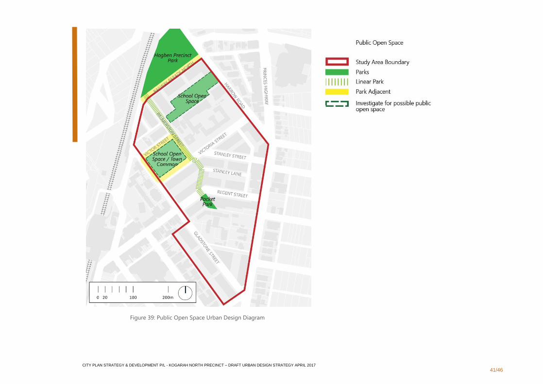
▪ Create three distinct public open spaces throughout the Precinct that are varied in scale, use and character and are linked by a pedestrian
landscaped spine. These three types of public open spaces are defined as:
▪ Precinct Park. Activities such as; open green, picnic spots, active sports, formal sports, informal play, larger group gatherings, habitat and
toilets
▪ Potential Community Hub Park. School uses and activities such as; school open space, formal play, table tennis/youth play, informal sport,
activated edges with seating etc., facilities and cafe and temporary markets
▪ Pocket Park. Activities such as; informal performance, community gardens, summer seating/ gardening rooms and informal play
CITY PLAN STRATEGY & DEVELOPMENT P/L - KOGARAH NORTH PRECINCT – DRAFT URBAN DESIGN STRATEGY APRIL 2017
41/46
Figure 39: Public Open Space Urban Design Diagram

CITY PLAN STRATEGY & DEVELOPMENT P/L - KOGARAH NORTH PRECINCT – DRAFT URBAN DESIGN STRATEGY APRIL 2017
42/46
3.2.8 Safety
Objectives
▪ To create a comfortable and safe environment for current and future residents, especially for the young people attending the three schools in
the Precinct
▪ To encourage good design that optimises safety and security within the development and the public domain
Strategies
▪ Adopt the principles of Crime Prevention Through Environmental Design (CEPTED)
▪ Capture opportunities to maximise passive surveillance of public and communal areas and promote safety.
▪ Ensure high quality materials, finishes and construction details are provided throughout the public domain and adjacent private domain
▪ Create opportunities for street activation through retail of various scales including outdoor dining areas
▪ Neighbourhood shops are to be provided on the ground floor of all Princes Highway frontages and are to be provided strategically within the
Precinct.
▪ Local streets and lanes are to prioritise pedestrian activities such as seating, informal play and community activities.
▪ Design for a varied human scale and a streetscape stimulation at eye level
▪ Articulate living room windows and kitchen windows to face streets to improve casual surveillance of streets and make habitation recognisable
from streets
▪ Provide clear crossing points and raised crossing points which prioritise pedestrian movements and are suitable for traffic calming
CITY PLAN STRATEGY & DEVELOPMENT P/L - KOGARAH NORTH PRECINCT – DRAFT URBAN DESIGN STRATEGY APRIL 2017
43/46
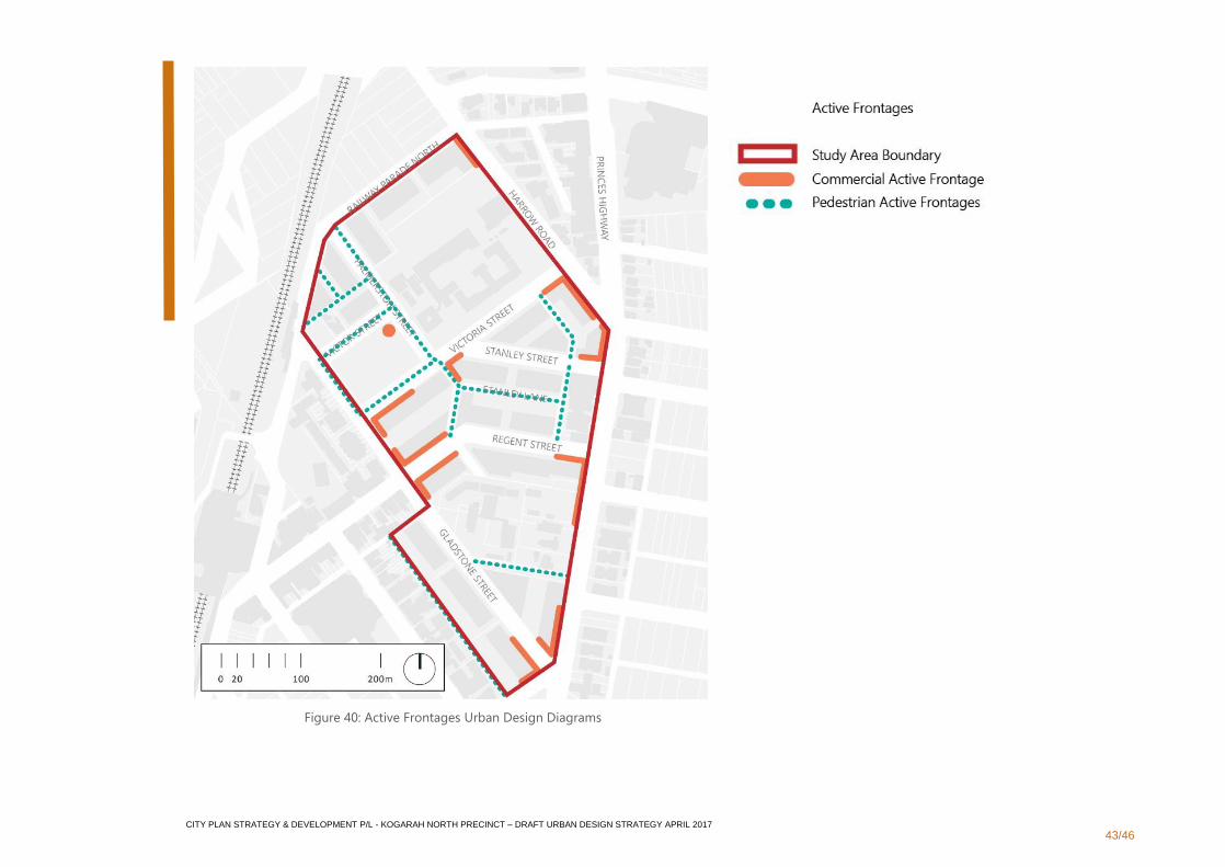
Figure 40: Active Frontages Urban Design Diagrams
CITY PLAN STRATEGY & DEVELOPMENT P/L - KOGARAH NORTH PRECINCT – DRAFT URBAN DESIGN STRATEGY APRIL 2017
44/46
3.2.9 Housing Diversity and Social Interaction
Objectives
▪ To optimise Kogarah North’s close proximity to major transport and major health and education institutions by increasing key worker housing
and opportunities for livable / adaptive dwellings
▪ To create an extensive range of living options for a wide range of household types and income levels
▪ To encourage design of streets that are accessible to all and are envisioned as ‘shared spaces’ with both vehicular, pedestrian and cyclist uses
that are all safe, well connected and activated promoting social activities
Strategies
▪ Provide a diverse mix of housing types and sizes suitable for all ages
▪ Provide for a variety of settings for formal and informal social interactions
▪ Design for appropriate street widths for human comfort and scale that provides suitable dimensions for footpath widths with access for all and
opportunities for places to stop, stay and inhabit
▪ Create adaptable streets and public domain spaces which accommodate a range of uses and activities
▪ Provide all weather protection in the form of awnings where suitable, to encourage outside activities
▪ Provide a range of public domain furniture
▪ Utilise appropriate non-slip paving materials
▪ Design to Australian Disability Discrimination Act standards to allow for usage of public spaces for all abilities and ages
▪ Provide a public domain of spaces that encourage a range opportunities such as; active and passive recreation, informal and formal seating,
children’s formal and informal play, exercise stations and sport activities, temporary markets and overlays, formal gathering space, community
gardens, picnic facilities and performances.

CITY PLAN STRATEGY & DEVELOPMENT P/L - KOGARAH NORTH PRECINCT – DRAFT URBAN DESIGN STRATEGY APRIL 2017
45/46
3.2.10 Aesthetics
Objectives
▪ Achieve variety with order; architectural diversity is encouraged within a regular and consistent built-form framework
▪ Material selection also has an important role in aesthetic quality, it has an important role to play in creating a cohesive and distinct visual
environment
▪ Overarching built form should reflect consistently applied strategies, while permitting diversity in detail and ‘personal touches’ in the
presentation of homes and community facilities
Strategies
▪ Limited pallet of predominant material either rendered masonry or face brick
▪ Streets of familiar design reflective the distinct usage and role of each street
▪ To all streets, except along the Princes Highway, Railway Parade North and major and secondary corners, provide five metre front building
setbacks that incorporates landscaping to the street to create useable front courtyards and allow for individualised landscaping of the space
between the street and the building
▪ Provide a 2-metre front building setback along Princes Highway and Railway Parade to strengthen their highly urban character
▪ Encourage street activation through individual pedestrian access to ground floor apartments from the street with personalised elements such
as planter boxes and ‘front porch’ furniture
▪ Moderate apparent height of ‘street wall’, by establishing a four-storey high built form, with upper levels setback by 3m
▪ Taller tower forms to be generally located on corner of super-blocks to emphasise urban structure and mark urban thresholds
▪ Throughout the plan area introduce parallel parking bays and footpath widening. At intersections introduce blisters to reduce crossing widths
and calm vehicular traffic
▪ New development adjacent to heritage items are to be appropriate in scale
CITY PLAN STRATEGY & DEVELOPMENT P/L - KOGARAH NORTH PRECINCT – DRAFT URBAN DESIGN STRATEGY APRIL 2017
46/46
4. Delivery Framework
4.1 Implementation
4.1.1 Development Control Plan
Following consideration by Council, it is intended that the principles
identified in this draft Urban Design Strategy be converted into a site-
specific chapter in the Kogarah Development Control Plan (DCP) 2013.
The purpose of a site specific chapter in the KDCP is to: guide
redevelopment in Kogarah North; assist in delivery of the vision for the
Precinct; and contribute to a co-ordinated approach to public domain
outcomes in the Precinct.
4.1.2 Planning Proposal
It is acknowledged that the principles and strategies identified within this
draft Urban Design Strategy may limit the ability to generate the full yield
potential anticipated on some sites within the Precinct.
One way of addressing this would be for applicants to be invited to lodge
a Planning Proposal to amend the 33-metre height limit.
Any Planning Proposal seeking to increase the maximum height limit in
order to increase yield will need to satisfactorily demonstrate:
1. Compliance with the Obstacle Limitation Surfaces;
2. Consistency with the urban design principles in this draft
strategy, particularly in relation to the Block and Corner
Hierarchy (Figure 35); and
3. Comprehensive analysis of the surrounding context to
determine an appropriate height that will not diminish the
development potential of surrounding sites.
4.1.3 R4 Zoning along Princes Highway Frontage
Land along Princes Highway is predominantly zoned R4 High Density
Residential which limits the permissibility of commercial uses which
could provide ground floor activation. We therefore suggest Council
consider an amendment to the zone to introduce additional permissible
uses as part of any future housekeeping LEP.
4.2 Funding Mechanisms
4.2.1 Section 94 Contributions Plan
In order to fund the public domain and other public works required to
support this draft Urban Design Strategy, it is recommended that
Council adopt an amendment to the existing Section 94 Contributions
Plan.
4.2.2 Voluntary Planning agreements
In order to deliver the public domain outcomes envisaged in this draft
Urban Design Strategy, there are opportunities for site specific
contributions to be made as part of a redevelopment proposal. In
particular, where through site links have been identified, we envisage
that this could be delivered as part of a Voluntary Planning Agreement
associated with the development application process
4.3 Next Steps
It is understood that Council will place this document on public
exhibition and seek feedback from interested stakeholders and
members of the community. Following this process, submissions will be
reviewed and the draft Urban Design Strategy will be updated
accordingly prior to final adoption by Georges River Council.
Recommended