FIG Working Week 2015 1
•Introduction
•Background of Course Modules
•The Modules and Syllabus
•Course Schedule
•Conclusion

FIG Working Week 2015 2
• The need for accurate information of existing underground utilities
• Mandate by the Malaysian Government to the Department of Survey and Mapping Malaysia (JUPEM) to compile underground utilities data.
• Knowledge in utility mapping and tertiary education is still lacking
• The challenge of issue is to merge the 3 core disciplines i.e. Electrical and Electricity, Geology and Geophysics, and Survey Mapping.
• Recognising the issue, the Land Surveyors Board of Malaysia (LJT) and the Association of Authorised Land Surveyors Malaysia (PEJUTA) taken the initiative to offer a professional course in UUSDM to its members.

FIG Working Week 2015 3
• A committee comprising of LJT, PEJUTA, JUPEM and University of Technology of Malaysia (UTM) was set-up to design the course
• The course design is to be in line with a Post-graduate standard level with addition of Professional practise input.
• The course is envisaged to have approximately 390 credit hours or equivalent to 26 study weeks
• The framework design is to provide fundamental and understanding,
system operation and applications, and professional practise.
• The quality, standard and recognition is regulated by accreditation
requirements such as exam, coursework, report, competency test
and demonstrate skills
• To complete a project paper/dissertation
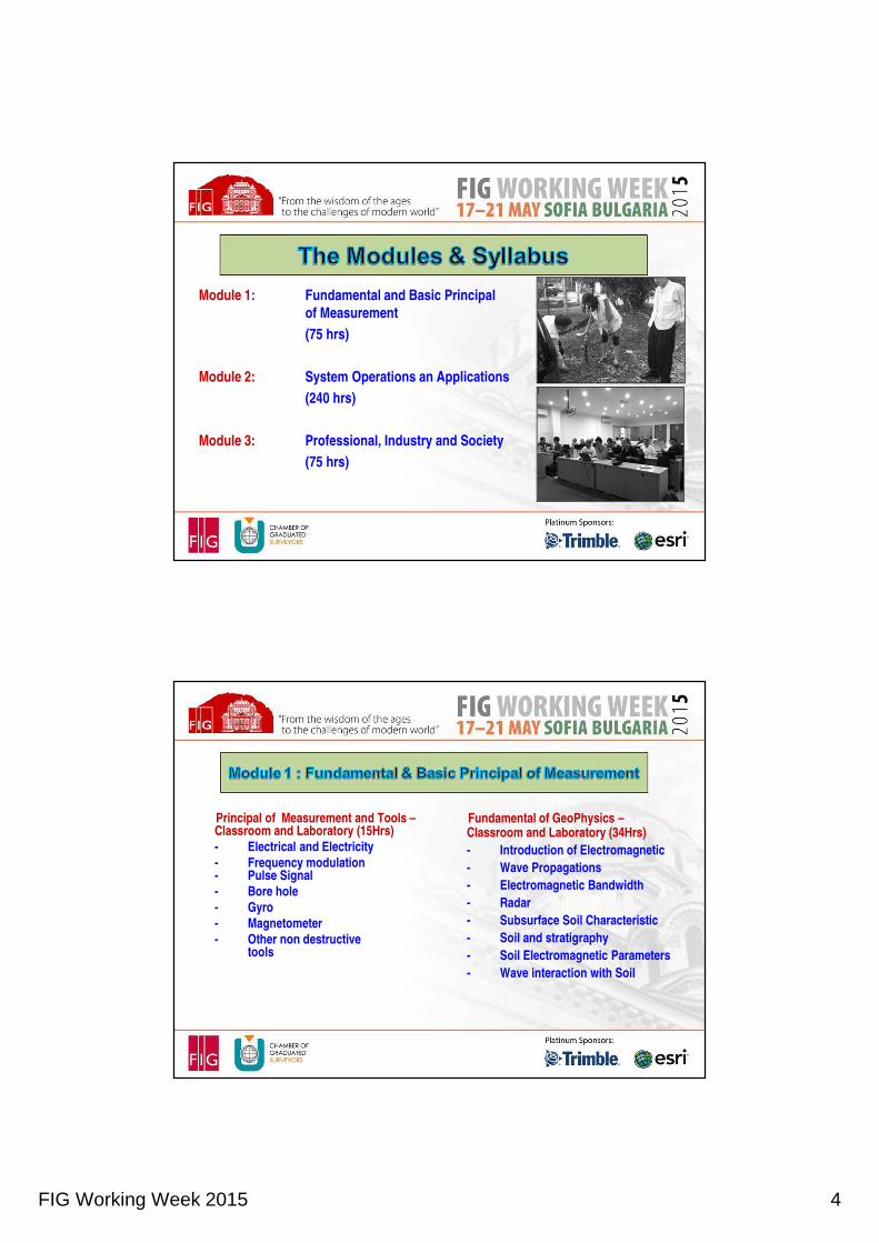
FIG Working Week 2015 4
Module 1: Fundamental and Basic Principal
of Measurement
(75 hrs)
Module 2: System Operations an Applications
(240 hrs)
Module 3: Professional, Industry and Society
(75 hrs)
Principal of Measurement and Tools –Classroom and Laboratory (15Hrs)
- Electrical and Electricity
- Frequency modulation- Pulse Signal
- Bore hole
- Gyro
- Magnetometer
- Other non destructive tools
Fundamental of GeoPhysics –Classroom and Laboratory (34Hrs)
- Introduction of Electromagnetic
- Wave Propagations
- Electromagnetic Bandwidth
- Radar
- Subsurface Soil Characteristic
- Soil and stratigraphy
- Soil Electromagnetic Parameters
- Wave interaction with Soil

FIG Working Week 2015 5
• Data Management, Data Processing and Interpretation - Computer Laboratory (17Hrs)
- Geographical Information Management
- Data acquisition
- Data processing
- Data interpretation of reflection data
- Data visualisation
• Limitation and Data Analysis -Classroom (9 hrs)
- Wave Penetration
- Absorption and reflection of electromagnetic wave
- Noise/Signal ratio
- Resolution vs Penetration
- Best practice
Coordinate system, adjustment and transformation, datum conversion and projection – Classroom and Laboratory (18hrs)
Introduction to Geodetic and Reference System and coordinates acquisition methodology
GNSS/Global Positioning System (GPS) – Satellite Geodesy, Global Navigation Satellite System (GNSS) n Geodetic Reference System
Control Survey Methodology – Radiation, Triangulation and resection
Transformation
Datum Conversion and Projection
Understanding of Local Projection system
GDM 2000 System
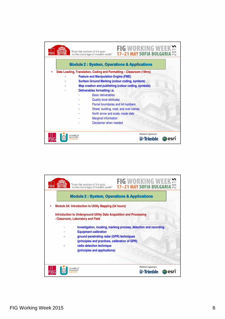
FIG Working Week 2015 6
• Data Loading, Translation, Coding and Formatting – Classroom (18hrs)
- Feature and Manipulation Engine (FME)
- Surface Ground Marking (colour coding, symbols)
- Map creation and publishing (colour coding, symbols)
- Deliverables formatting i.e.
- Basic deliverables
- Quality level attributes
- Parcel boundaries and lot numbers
- Street, building, road, and river names
- North arrow and scale, made date
- Marginal information
- Disclaimer when needed
• Module 2A: Introduction to Utility Mapping (54 hours)
Introduction to Underground Utility Data Acquisition and Processing
- Classroom, Laboratory and Field
- Investigation, locating, marking process, detection and recording
- Equipment calibration
- ground penetrating radar (GPR) techniques
(principles and practices, calibration of GPR)
- radio detection technique
(principles and applications)

FIG Working Week 2015 7
• (principles and practice, calibration of PCL)
Pipe and Cable Locator (PCL)Pipe and Cable Locator (PCL)
• (gyro-based pipeline mapping systems, etc.)
Other methods of detectionOther methods of detection
Survey methodology and positioning methodsSurvey methodology and positioning methods
Positioning and Marking TolerancePositioning and Marking Tolerance
Survey data processingSurvey data processing
PCL data processing and analysis PCL data processing and analysis
GPR data interpretation and processing, data editingGPR data interpretation and processing, data editing
Data processing feature and attribute codesData processing feature and attribute codes
Data processing for other detection techniquesData processing for other detection techniques
• Module 2B: Underground Utility Data
Acquisition (30 hours)
- Principles of Pre- Utility Investigation
- Survey Procedures
- Survey deliverables
- Development of a Survey Strategy

FIG Working Week 2015 8
Troubleshooting Processing & Interpretation
Troubleshooting Processing & Interpretation
Inappropriate Utility Detection Technology Inappropriate Utility
Detection Technology
Log Report of Practical utility detection (30 hours)
Log Report of Practical utility detection (30 hours)
Preparation of Dissertation/Project (40 hours)
Preparation of Dissertation/Project (40 hours)
Utility Mapping Standards & Safety Requirements - Classroom and Technical Visit (30 hrs)
Related enactments and legislations
Introduction to Malaysian Standards and Government Circulars – Example: Stratum Act.
Features and Attributes Codes forUtility Mapping in Malaysian Standard(MS1759)
Malaysian Standards for GeographicInformation - Metadata

FIG Working Week 2015 9
Director General of Survey and Mapping Circulars (Standard Guideline on Utility Mapping)
Health and Safety Requirements for Utility Mapping (DOSH, NIOSH, OSHA)
Understanding of Professional and Public Liabilities
Underground utilities system design, Construction standards and practices.- Classroom and Technical Visit (45 hrs)
Standard Guidelines for Underground Utility Mapping
Introduction and Roles of the Land Surveyor and detecting tasks (utility owner, land surveyor, JUPEM)
Utility quality level attributes (Quality Levels D, C, B, A)
Understanding Utilities Network and Print Reading Fundamental (Eg.: Syabas, TNB, and Telekom
Network)
Maintenance of the National Underground Utility Database (PADU)
Other Standard Guidelines
Horizontal Directional Drills (HDD) and Bore Hole Drilling - Industry Practice (Presentation)
Other related UUM practice. Eg. Forensic (Uniten) & Gasteg (UTM)

FIG Working Week 2015 10
Module 1: Fundamental and BasicPrincipal of Measurement(75 hrs)
M1 Syllabus n subject (FIG).pdf
\M1 Subject Details.pdf
Module 2: System Operationsand Applications(240 hrs)
M2 Subject Details (FIG).pdf
• Accredit for all written coursework, report and documentation
• for each module/syllabus.
• Accredit Dissertation/Project documentation form.
• Competency test and demonstrate skills.
• Oral/Interview
(Panel of Accreditation)
• Certification Award of CUUDM

FIG Working Week 2015 11
Course schedule
Course Schedule Sample.xlsx
Course Schedule Sample
Conclusion
To date 79 candidates have been awarded with a UUDSM Certificate
- Another 20 will be graduating soon after successful submission of their project paper.
- Graduates from the program have the knowledge and skill to provide a strong foundation and professional support towards establishing a respectable and reliable source of professional service to the nation as it strive to be a developed nation by 2020.
FIG Working Week 2015 12
Conclusion
• From a surveyor view point a country cannot claim to be fully
developed if it fails, among other things, to reliably map and thus
efficiently manage its underground utilities.
• This course is a contribution by Malaysian surveyors towards
achieving the national aspiration.

FIG Working Week 2015 13
Recommended