1
Hurricane AgnesHurricane AgnesJen SomervilleJen SomervilleOct 19, 2005Oct 19, 2005
Severe Storms Severe Storms
OutlineOutline
!! Basic Hurricane reviewBasic Hurricane review!! Hurricane AgnesHurricane Agnes-- why was it so specialwhy was it so special!! Damages/deathDamages/death!! New YorkNew York!! PennsylvanisPennsylvanis!! MitigationMitigation
Where Hurricanes form and Where Hurricanes form and Hurricane SeasonsHurricane Seasons
Hurricane season is June 1st � November 30th
Anatomy of a HurricaneAnatomy of a Hurricane1. Rain Shield:
- Solid wall of rain that becomes heavier closer to the eye.
2. Spiral Rain Bands:
- Regions of active showers and thunderstorms that circle the center of the cyclone
3. Eye Wall
- Well organized band of intense thunderstorms that is typically 15 miles wide and has the strongest winds and most intense rainfall
4. Eye
- The calm center of the storm. The smaller the eye, the more intense the storm.
Hurricane Agnes HistoryHurricane Agnes History1. Was labeled a tropical disturbance on
June 14, 1972 off the coast of the Yucatan Pennisula.
2. Became Tropical Storm Agnes on June 16, 1972 in the northwestern part of the Caribbean.
3. Became Hurricane Agnes on June 17, 1972 and its path turned northward.
4. Made landfall along the Florida Panhandle on June 19, 1972.
5. Restrengthed to a tropical storm when it re-enterd the Atlantic Ocean
6. Made a seond land fall as a strong tropical storm on June 22, 1972 in New York
7. Got absorbed by a low pressure system on June 23, 1972
2
Hurricane AgnesHurricane AgnesInteresting & Unusual Facts
-Storm was larger than most, with a diameter of 1,000 miles
- At the time it was the costliest disaster to hit the U.S. and stayed that way till Hurricane Andrew in 1992.
- Pennsylvania and New York were the hardest hit areas!
- The name Agnes was retired after this storm
1,155,000,00021998Georges (Fl Keys, MS, AL)20
1,250,000,00031985Elena (MS, AL, NW FL)19
1,420,500,00031965Betsy (SE FL, SE LA)18
1,420,700,00051969Camille (MS, SE LA, VA)17
1,500,000,00011985Juan (LA)16
1,500,000,00021991Bob (NC, NE U.S.)15
2,000,000,00031983Alicia (N TX)14
2,100,000,00011972Agnes (Fl, NE U.S)13
2,300,000,00031979Frederic (AL, MS)12
3,000,000,00031995Opal (NW Fl, AL)11
3,200,000,00031996Fran (NC)10
3,370,000,00022003Isabel (Mid-Atlantic)9
4,500,000,00021999Floyd (Mid-Atlantic & NE U.S.)8
5,000,000,000TS2001Allison (N TX)7
6,900,000,00032004Jeanne (FL)6
7,000,000,00041989Hugo (SC)5
8,900,000,00022004Frances (FL)4
14,200,000,00032004Ivan (AL, NW FL)3
15,000,000,00042004Charley (SW FL)2
26,500,000,00051992Andrew (Se Fl, Se LA)1
DamageCategoryYearHurricaneRank
117$3,102,571,380Total
1LightDelaware
0$50,000South Carolina
0$205,000Georgia
2$6,558,380North Carolina
0$6,818,000Ohio
0$7,753,000West Virginia
9$8,243,000Florida
1$15,000,000New Jersey
19$110,186,000Maryland
13$125,987,000Virginia
24$702,502,000New York
48$2,119,269,000Pennsylvania
DeathsDamageState
Precursors Precursors !! Hurricane Agnes was the first hurricane of the 1972 Hurricane Agnes was the first hurricane of the 1972
season, and it occurred early in the seasonseason, and it occurred early in the season!! The three weeks prior to Agnes, Pennsylvania received The three weeks prior to Agnes, Pennsylvania received
22--3 inches of rain.3 inches of rain.!! New York received an inch of rain the week prior to New York received an inch of rain the week prior to
Hurricane Agnes.Hurricane Agnes.!! Plus there was still spring snow melt influencesPlus there was still spring snow melt influences!! Rivers weren't flooded, but were higher than normal.Rivers weren't flooded, but were higher than normal.!! Most people in the North East did not pay attention to the Most people in the North East did not pay attention to the
storm because they figured it would not affect them.storm because they figured it would not affect them.
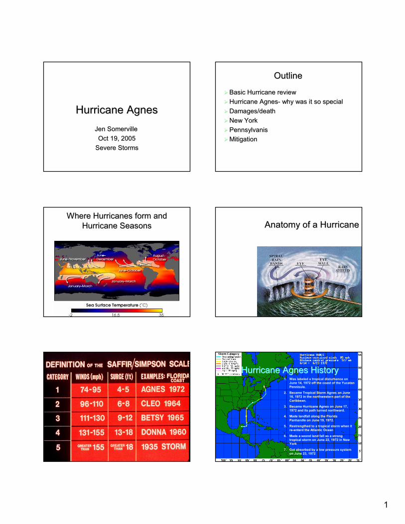
New YorkNew York
!! The Genesee River and its tributaries The Genesee River and its tributaries were greatly affected by Hurricane Agnes.were greatly affected by Hurricane Agnes.
!! FloodingFlooding"" Flooding in the upper part of the Genesee, Flooding in the upper part of the Genesee,
above the Mt. Morris dam, broke all historic above the Mt. Morris dam, broke all historic records for floods.records for floods.
"" Flooding in the lower part of the river was Flooding in the lower part of the river was sparred massive flooding due to the dam.sparred massive flooding due to the dam.
3
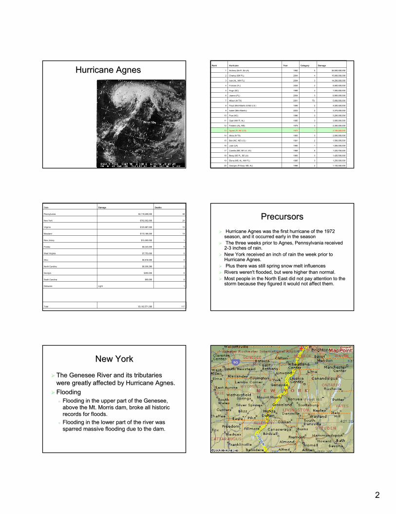
Rainfall Rainfall amountsamounts
* represents flood of record
40.7 ft *10csm16,500 cfsAvonGenesee
35.2 ft *91 csm90,000 cfsPortagevilleGenesee
20.7 ft *134 csm38,500 cfsWellsvilleGenesee
Stagecfs/sq mileFlowLocationRiver
Why was Rochester Spared?Why was Rochester Spared?!! Officials were concerned that the dam would Officials were concerned that the dam would
overtop, which would cause major downstream overtop, which would cause major downstream flooding.flooding.
!! Close monitoring and Close monitoring and carefullcarefull releases of the releases of the dam water resulted in limited flooding.dam water resulted in limited flooding.
!! Inflow into the dam was 90,000 Inflow into the dam was 90,000 cfscfs. Outflow . Outflow downstream was limited to 15,000 downstream was limited to 15,000 cfscfs
!! The Corps of Engineers estimated that the The Corps of Engineers estimated that the operations at the Dam during the storm operations at the Dam during the storm prevented over $200 million in potential damage.prevented over $200 million in potential damage.
Today
June 23, 1972
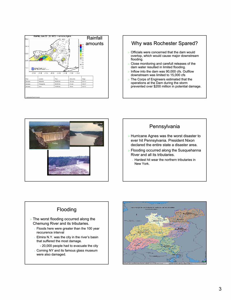
PennsylvaniaPennsylvania
!! Hurricane Agnes was the worst disaster to Hurricane Agnes was the worst disaster to ever hit Pennsylvania. President Nixon ever hit Pennsylvania. President Nixon declared the entire state a disaster area.declared the entire state a disaster area.
!! Flooding occurred along the Susquehanna Flooding occurred along the Susquehanna River and all its tributaries.River and all its tributaries."" Hardest hit wear the northern tributaries in Hardest hit wear the northern tributaries in
New York.New York.
FloodingFlooding
!! The worst flooding occurred along the The worst flooding occurred along the Chemung River and its tributaries.Chemung River and its tributaries."" Floods here were greater than the 100 year Floods here were greater than the 100 year
reccurencereccurence intervalinterval"" Elmira N.Y. was the city in the river�s basin Elmira N.Y. was the city in the river�s basin
that suffered the most damage.that suffered the most damage.-- 20,000 people had to evacuate the city20,000 people had to evacuate the city
"" Corning NY and its famous glass museum Corning NY and its famous glass museum were also damaged.were also damaged.
isis
4
Flooding in WilkesFlooding in Wilkes--BarreBarre
!! WilkesWilkes--Barre had been flooded before, in Barre had been flooded before, in 1936 when the river was 33 ft above flood 1936 when the river was 33 ft above flood level.level.
!! To keep the town from being flooded again To keep the town from being flooded again the town had dikes built to 37 ft, figuring it the town had dikes built to 37 ft, figuring it would keep the water out of the city.would keep the water out of the city.
!! During Agnes, the river peaked at 40 ft During Agnes, the river peaked at 40 ft above flood level.above flood level.
WilkesWilkes--Barre continuedBarre continued
!! The National Weather Service staff in The National Weather Service staff in Harrisburg predicted that the River would Harrisburg predicted that the River would overtop the levees build after the historic overtop the levees build after the historic 1936 flood.1936 flood.
!! This prediction allowed for the safe This prediction allowed for the safe evacuation of 100,000 people in the area.evacuation of 100,000 people in the area.
Mitigation evaluationMitigation evaluation
!! Warnings and population awarenessWarnings and population awareness"" The Population was aware that more rain The Population was aware that more rain
could cause the already high rivers to flood.could cause the already high rivers to flood."" They were warned in enough time to be able They were warned in enough time to be able
to safely evacuate their homes.to safely evacuate their homes.
ReferencesReferences!! http://www.houstontx.gov/oem/formation.htmlhttp://www.houstontx.gov/oem/formation.html!! http://earthobservatory.nasa.gov/Library/Hurricanes/Images/hurrihttp://earthobservatory.nasa.gov/Library/Hurricanes/Images/hurricane_formation.jpgcane_formation.jpg!! http://www.wunderground.com/hurricane/at197202.asphttp://www.wunderground.com/hurricane/at197202.asp!! http://en.wikipedia.org/wiki/Hurricane_Agneshttp://en.wikipedia.org/wiki/Hurricane_Agnes!! http://www1.ncdc.noaa.gov/pub/data/images/hurricane_agnes_1972_vhttp://www1.ncdc.noaa.gov/pub/data/images/hurricane_agnes_1972_vis.gifis.gif!! Http://www.usatoday.com/weather/whagnes.htmHttp://www.usatoday.com/weather/whagnes.htm!! http://www.weather.com/newscenter/specialreports/sotc/storm10/aghttp://www.weather.com/newscenter/specialreports/sotc/storm10/agnes/page4.htmlnes/page4.html!! http://www.nhc.noaa.gov/pastcost/shtmlhttp://www.nhc.noaa.gov/pastcost/shtml
!! http://encarta.msn.com/encnet/features/mapcenter/map.aspx?refid=http://encarta.msn.com/encnet/features/mapcenter/map.aspx?refid=701510721701510721!! http://www.erh.noaa.gov/er/nerfc/historical/jun1972.htmhttp://www.erh.noaa.gov/er/nerfc/historical/jun1972.htm!! http://www.srbc.net/gis/view.asp?img=image/140b.jpghttp://www.srbc.net/gis/view.asp?img=image/140b.jpg!! http://http://images.google.com/imgres?imgurlimages.google.com/imgres?imgurl=http://=http://www.letchworthparkhistory.com/moddwww.letchworthparkhistory.com/modd
am.jpg&imgrefurlam.jpg&imgrefurl=http://www.letchworthparkhistory.com/flood3.html&h=191&w=300&=http://www.letchworthparkhistory.com/flood3.html&h=191&w=300&sz=19&tbnid=qh7KQgTOeHAJ:&tbnh=70&tbnw=111&hl=en&start=8&prev=/isz=19&tbnid=qh7KQgTOeHAJ:&tbnh=70&tbnw=111&hl=en&start=8&prev=/images%mages%3Fq%3Dmt%2Bmorris%2Bdam%26svnum%3D10%26hl%3Den%26lr%3D%26sa%33Fq%3Dmt%2Bmorris%2Bdam%26svnum%3D10%26hl%3Den%26lr%3D%26sa%3DNDN
Questions?Questions?
Recommended