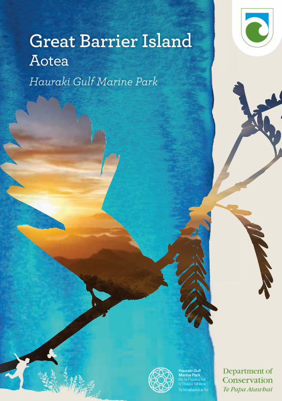
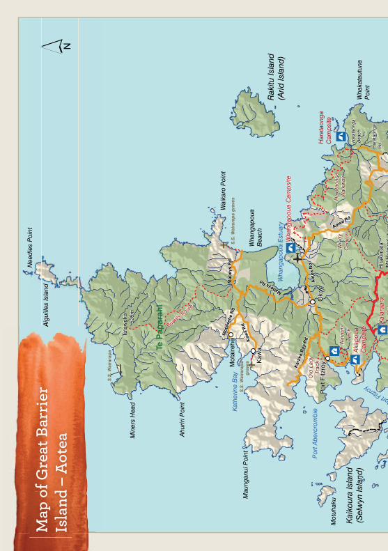
Great Barrier Island AoteaHauraki Gulf Marine Park
Editing and design:
Publishing Team, DOC National Office
Contents
Cover photo and photo this page: Eugene Polkan.
Aotea and Ngāti Rehua 1
Linking land and sea 2
Rich history 4
Living treasures 6
Wild spaces 8
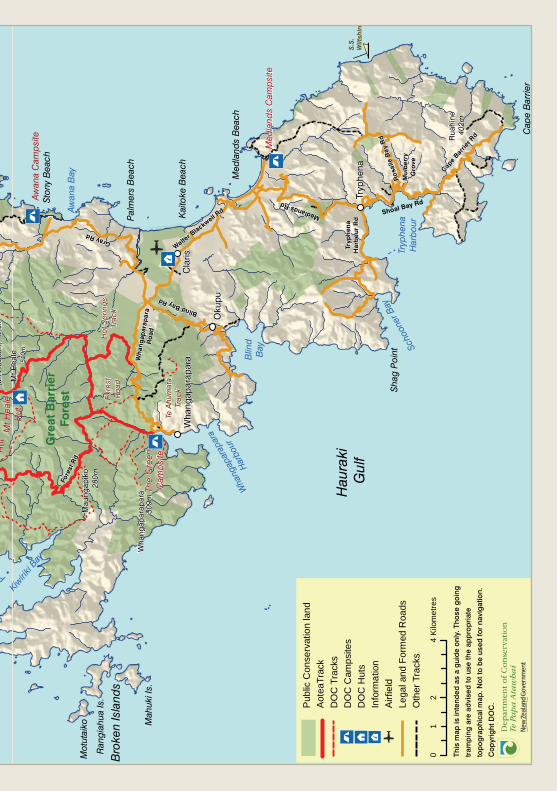
Island map 10
Detailed map of tracks 12
Aotea Track, multi-day walk 14
Hirakimata (Mt Hobson) summit tracks 16
Hot Springs and Peach Tree Tracks 17
Kaiaraara Track 18
Windy Canyon and Palmers Track 19
Whangaparapara area tracks 20
Tramline, Pack, and Withey’s Tracks 20
Mount Whangaparapara and Old Mill Tracks, Te Ahumata Track 21
Port Fitzroy area tracks 22
Old Lady Track, Warren’s and Bridle Tracks 22
Bush’s Beach, Kiwiriki, Line W, and South Fork Tracks, Forest Road 23
Okiwi/Harataonga area tracks 24
Harataonga Coastal Walkway, Harataonga Loop Track, Cooper’s Castle Track 24
Tramline Track, Burrill Route 25
Birds of Aotea 26
Looking after Aotea 30
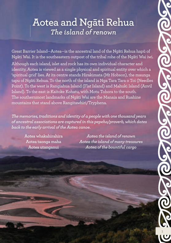
Great Barrier Island—Aotea—is the ancestral land of the Ngāti Rehua hapū of Ngāti Wai. It is the southeastern outpost of the tribal rohe of the Ngāti Wai iwi.Although each island, islet and rock has its own individual character and identity, Aotea is viewed as a single physical and spiritual entity over which a ‘spiritual grid’ lies. At its centre stands Hirakimata (Mt Hobson), the maunga tapu of Ngāti Rehua. To the north of the island is Nga Tara Tara o Toi (Needles Point). To the west is Rangiahua Island (Flat Island) and Mahuki Island (Anvil Island). To the east is Kaitoke Kohatu, with Motu Tohora to the south. The southernmost landmarks of Ngāti Wai are the Manaia and Ruahine mountains that stand above Rangitawhiri/Tryphena.
Aotea and Ngāti Rehua The island of renown
The memories, traditions and identity of a people with one thousand years of ancestral associations are captured in this pepeha/proverb, which dates back to the early arrival of the Aotea canoe.
Aotea whakahirahiraAotea taonga maha
Aotea utanganui
Aotea the island of renownAotea the island of many treasures
Aotea of the bountiful cargo
1
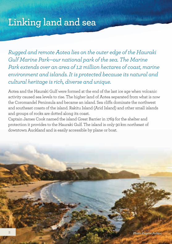
Linking land and sea
Rugged and remote Aotea lies on the outer edge of the Hauraki Gulf Marine Park—our national park of the sea. The Marine Park extends over an area of 1.2 million hectares of coast, marine environment and islands. It is protected because its natural and cultural heritage is rich, diverse and unique.Aotea and the Hauraki Gulf were formed at the end of the last ice age when volcanic activity caused sea levels to rise. The higher land of Aotea separated from what is now the Coromandel Peninsula and became an island. Sea cliffs dominate the northwest and southeast coasts of the island. Rakitu Island (Arid Island) and other small islands and groups of rocks are dotted along its coast.Captain James Cook named the island Great Barrier in 1769 for the shelter and protection it provides to the Hauraki Gulf. The island is only 90 km northeast of downtown Auckland and is easily accessible by plane or boat.
Photo: Eugene Polkan.2
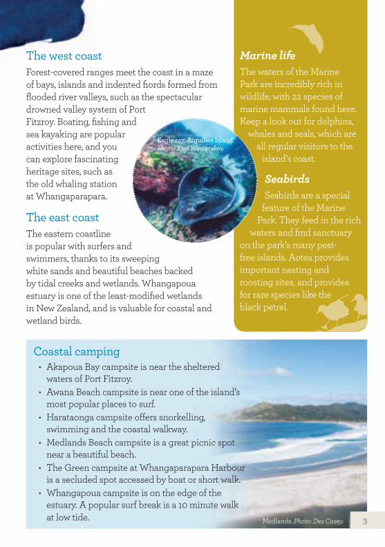
The west coast Forest-covered ranges meet the coast in a maze of bays, islands and indented fiords formed from flooded river valleys, such as the spectacular drowned valley system of Port Fitzroy. Boating, fishing and sea kayaking are popular activities here, and you can explore fascinating heritage sites, such as the old whaling station at Whangaparapara.
The east coastThe eastern coastline is popular with surfers and swimmers, thanks to its sweeping white sands and beautiful beaches backed by tidal creeks and wetlands. Whangapoua estuary is one of the least-modified wetlands in New Zealand, and is valuable for coastal and wetland birds.
Marine lifeThe waters of the Marine Park are incredibly rich in wildlife, with 22 species of marine mammals found here. Keep a look out for dolphins,
whales and seals, which are all regular visitors to the
island’s coast.
SeabirdsSeabirds are a special
feature of the Marine Park. They feed in the rich
waters and find sanctuary on the park’s many pest-free islands. Aotea provides important nesting and roosting sites, and provides for rare species like the black petrel.
Coastal camping• Akapoua Bay campsite is near the sheltered
waters of Port Fitzroy.• Awana Beach campsite is near one of the island’s
most popular places to surf. • Harataonga campsite offers snorkelling,
swimming and the coastal walkway.• Medlands Beach campsite is a great picnic spot
near a beautiful beach. • The Green campsite at Whangaparapara Harbour
is a secluded spot accessed by boat or short walk.• Whangapoua campsite is on the edge of the
estuary. A popular surf break is a 10 minute walk at low tide.
Eagle ray, Aiguilles Island. Photo: Kim Westerskov.
Medlands. Photo: Des Casey. 3
Aotea is home to a community of around 800 residents, and has been continuously inhabited for much of the past 1000 years. Māori oral history speaks of early occupation, and of Ngāti Wai and its chief Rehua settling on Aotea and claiming mana whenua over the land in the late 1700s. Being ancestral land, all of the island is sacred land to Māori. Its forests, bays and rivers tell stories of journeys, battles, living off the land and settlement.You can experience the island’s culture and heritage by visiting some of the fascinating historic sites. Archaeological sites in accessible coastal areas have been dated to the earliest period of Polynesian settlement.From the 1840s, the island’s natural resources attracted European settlement. A number of boom and bust industries exploited the island’s forests, minerals (copper, silver, gold) and migrating whales.
Aotea is home to a community of around 800 residents, and has
Rich history
MiningCopper was discovered in the remote northern part of the island in 1841, with New Zealand’s earliest mine being established at Miners Head in 1842. Gold and silver were discovered in the 1890s. The massive stone walls of the Oreville stamping (ore crushing) battery—above and below Whangaparapara Road—are an impressive reminder of the mining period.
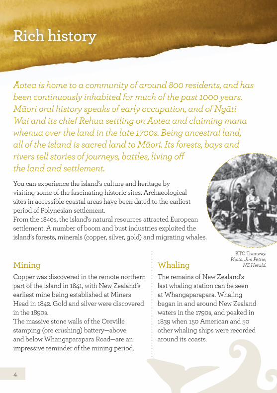
WhalingThe remains of New Zealand’s last whaling station can be seen at Whangaparapara. Whaling began in and around New Zealand waters in the 1790s, and peaked in 1839 when 150 American and 50 other whaling ships were recorded around its coasts.
KTC Tramway. Photo: Jim Petrie,
NZ Herald.
4
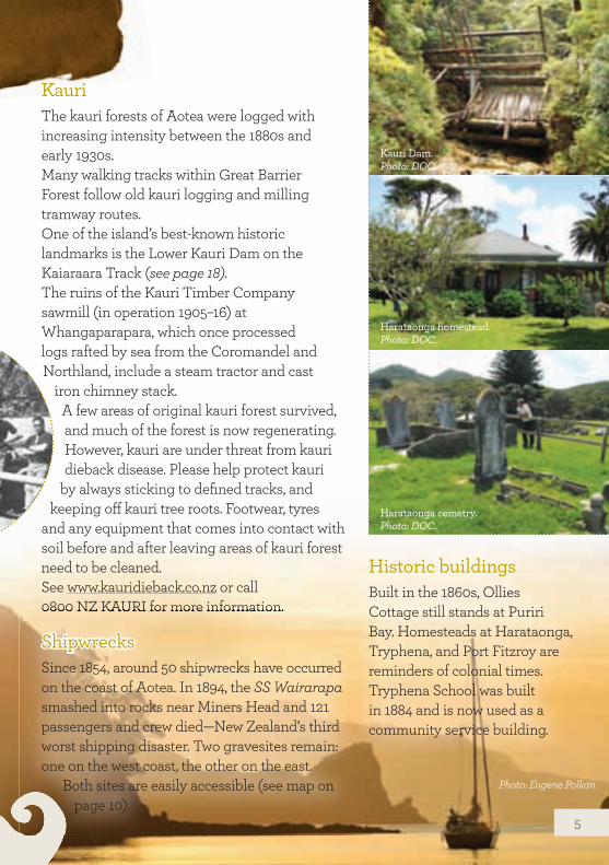
Kauri The kauri forests of Aotea were logged with increasing intensity between the 1880s and early 1930s.Many walking tracks within Great Barrier Forest follow old kauri logging and milling tramway routes.One of the island’s best-known historic landmarks is the Lower Kauri Dam on the Kaiaraara Track (see page 18). The ruins of the Kauri Timber Company sawmill (in operation 1905–16) at Whangaparapara, which once processed logs rafted by sea from the Coromandel and Northland, include a steam tractor and cast
iron chimney stack.A few areas of original kauri forest survived, and much of the forest is now regenerating. However, kauri are under threat from kauri dieback disease. Please help protect kauri
by always sticking to defined tracks, and keeping off kauri tree roots. Footwear, tyres
and any equipment that comes into contact with soil before and after leaving areas of kauri forest need to be cleaned. See www.kauridieback.co.nz or call 0800 NZ KAURI for more information.
Historic buildingsBuilt in the 1860s, Ollies Cottage still stands at Puriri Bay. Homesteads at Harataonga, Tryphena, and Port Fitzroy are reminders of colonial times. Tryphena School was built in 1884 and is now used as a community service building.
0800 NZ KAURI for more information.
ShipwrecksSince 1854, around 50 shipwrecks have occurred on the coast of Aotea. In 1894, the SS Wairarapa smashed into rocks near Miners Head and 121 passengers and crew died—New Zealand’s third worst shipping disaster. Two gravesites remain: one on the west coast, the other on the east.
Both sites are easily accessible (see map on page 10).
Kauri Dam. Photo: DOC.
Harataonga homestead. Photo: DOC.
Harataonga cemetry. Photo: DOC.
Photo: Eugene Polkan
5
Living treasures
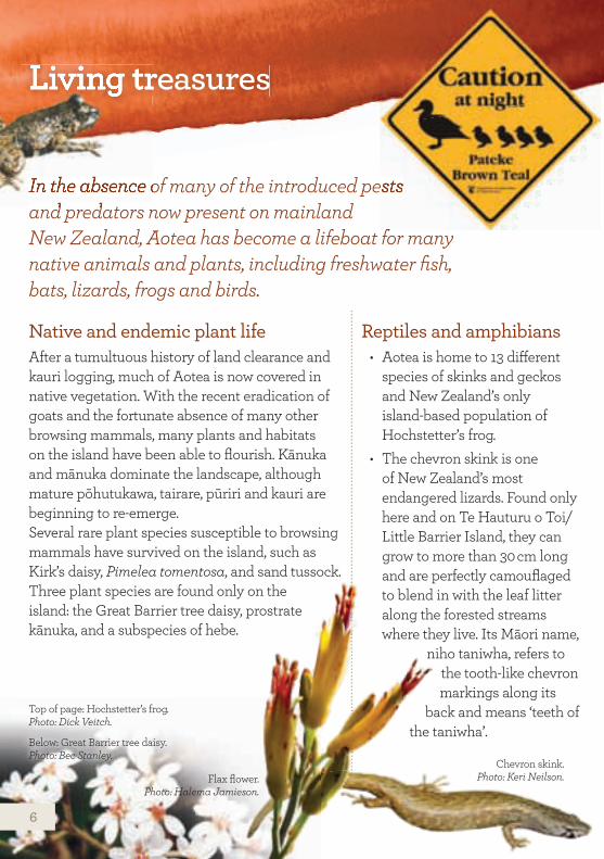
In the absence of many of the introduced pests and predators now present on mainland New Zealand, Aotea has become a lifeboat for many native animals and plants, including freshwater fish, bats, lizards, frogs and birds.
Native and endemic plant life After a tumultuous history of land clearance and kauri logging, much of Aotea is now covered in native vegetation. With the recent eradication of goats and the fortunate absence of many other browsing mammals, many plants and habitats on the island have been able to flourish. Kānuka and mānuka dominate the landscape, although mature pōhutukawa, tairare, pūriri and kauri are beginning to re-emerge. Several rare plant species susceptible to browsing mammals have survived on the island, such as Kirk’s daisy, Pimelea tomentosa, and sand tussock.Three plant species are found only on the island: the Great Barrier tree daisy, prostrate kānuka, and a subspecies of hebe.
Reptiles and amphibians • Aotea is home to 13 different
species of skinks and geckos and New Zealand’s only island-based population of Hochstetter’s frog.
• The chevron skink is one of New Zealand’s most endangered lizards. Found only here and on Te Hauturu o Toi/Little Barrier Island, they can grow to more than 30 cm long and are perfectly camouflaged to blend in with the leaf litter along the forested streams where they live. Its Māori name,
niho taniwha, refers to the tooth-like chevron markings along its
back and means ‘teeth of the taniwha’.
In the absence of many of the introduced pests
New Zealand, Aotea has become a lifeboat for many
Living treasures
In the absence of many of the introduced pests and predators now present on mainland
Chevron skink. Photo: Keri Neilson.
Below: Great Barrier tree daisy. Photo: Bec Stanley.
Flax flower. Photo: Halema Jamieson.
Top of page: Hochstetter’s frog. Photo: Dick Veitch.
6
Birds Many of the birds on Aotea are now rare or extinct on the mainland. They can be secretive and require patience to spot. Keep an eye out for the ones below (see page 26 for images).
Pāteke/brown teals Pāteke/brown teals are among the rarest ducks in the world and are considered nationally vulnerable. Aotea is home to almost two-thirds of the remaining world population. They are mainly active at night, but can commonly be seen foraging along estuaries and the water’s edge during the day. They are extremely vulnerable to predation and are often hit by cars on the road at night. Please take care when driving.
Shore birds and waders • Native and migrant species such as the
Caspian tern, wrybill, pied stilt, banded dotterel and bar-tailed godwit.
• Most conspicuous in summer are the New Zealand dotterel and variable oystercatcher. These birds breed above the high-tide line, mostly on the white sandy beaches along the east coast of the island. Their nests are well camouflaged and easily trampled.
Seabirds • Black petrels (see page 16), Australasian
gannets, common diving petrels, fluttering shearwaters, Cook’s petrels, grey-faced petrels, little blue penguins and Buller’s shearwaters.
• The recently rediscovered New Zealand storm petrel is also sometimes spotted off the north of the island.
Banded railsOften mistaken for baby weka, banded rails are a common sight. They often run out on the road, so please take care when driving!
Marine life• Blue maomao, snapper,
piper, sea turtles, sunfish, common and bottlenose dolphins and orca. Also Brydes, southern right and humpback whales.
If you discover a stranded whale or dolphin (dead or alive), please report it to 0800 DOCHOT (0800 362 468) immediately.
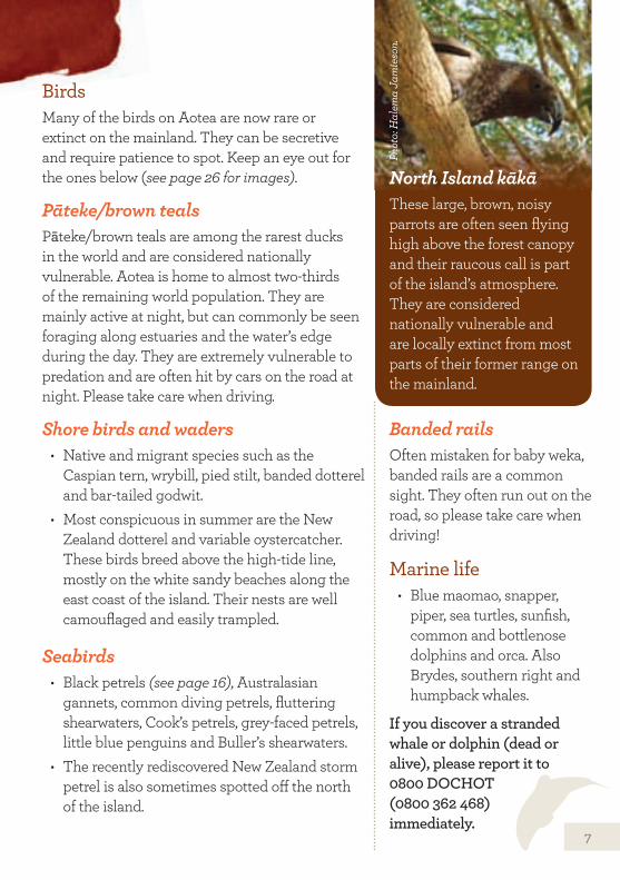
North Island kākāThese large, brown, noisy parrots are often seen flying high above the forest canopy and their raucous call is part of the island’s atmosphere. They are considered nationally vulnerable and are locally extinct from most parts of their former range on the mainland.
Phot
o: H
alem
a Ja
mie
son.
7
Wild spaces
In the centre of the island, spectacular bluffs and ridges rise to the highest peak— Hirakimata (Mt Hobson) at 621 m. The clear, warm waters surrounding the island are perfect for swimming, diving and snorkelling, and some of the eastern beaches can whip up some of the best surf in the country.
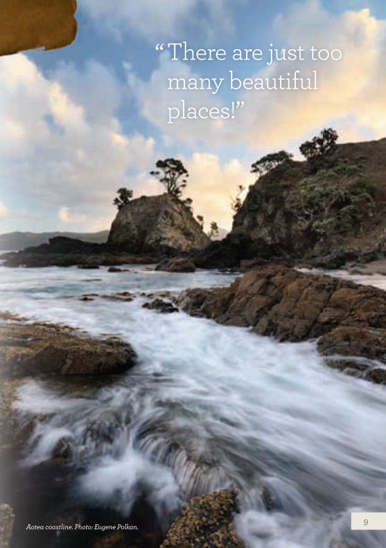
Outstanding views are in oversupply. One visitor once remarked, “There are just too many
beautiful places!” Take a gentle walk along one of the many
lowland bush trails or hike through beautiful regenerating coastal forest. Form the only set of footprints on a magnificent white, sandy beach and relax in the warm, secluded hot pools on the road to Whangaparapara.The wild landscapes of Aotea provide
the perfect backdrop for an adventurous, active holiday, or a relaxing unwind and
escape from city life.
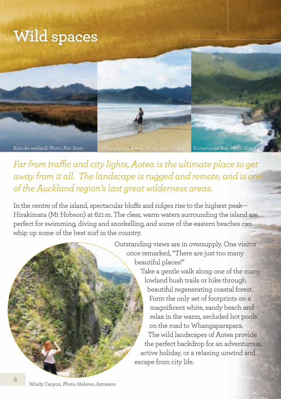
Kaitoke wetland. Photo: Ken Scott. Whangapoua Beach. Photo: Alan Phelps. Komahunga Bay. Photo: Ken Scott.
Windy Canyon. Photo: Halema Jamieson.
Far from traffic and city lights, Aotea is the ultimate place to get away from it all. The landscape is rugged and remote, and is one of the Auckland region’s last great wilderness areas.
8
Aotea coastline. Photo: Eugene Polkan.
There are just too many beautiful places!”
“
9
10
Hau
raki
G
ulf
Kai
kour
a Is
land
(Sel
wyn
Isla
nd)
Rak
itu Is
land
(Arid
Isla
nd)
Ao
tea
/ G
reat
Bar
rier
Isla
nd
Gre
at B
arri
erFo
rest
Oki
wi
Cla
ris
Mot
aire
he
Wha
ngap
oua
Bea
ch
Oku
pu
Tryp
hena
Wha
ngap
arap
ara B
lind
Bay
Tryp
hena
Har
bour
Kat
herin
e B
ay
Wha
ngap
arap
ara
Harb
our
Port Fitzr
oy
Kiwiri
ki Bay
Por
t Abe
rcro
mbi
e
Ston
y B
each
Awan
a B
ay
Wha
ngap
oua
Estu
ary
Awan
a C
amps
ite
Wha
ngap
oua
Cam
psi
te
Aka
pou
a C
amps
ite
The
Gre
en
Cam
psite
Med
land
s C
amps
ite
Kaw
a
Wai
karo
Poi
nt
Wha
kata
utun
aP
oint
Te P
apar
ahi
Pal
mer
s B
each
Kai
toke
Bea
ch
Med
land
s B
each
Cap
e B
arrie
r
Shag
Poi
nt
Mot
uhak
u
Bro
ken
Isla
nds
Mot
utai
ko
Ran
giah
ua Is
.
Mah
uki I
s.
Mau
ngan
ui P
oint
Ahu
riri P
oint
Min
ers
Hea
d
Aig
uille
s Is
land
Nee
dles
Poi
nt
Burrills
Route
S.S
. Wai
rara
pa
Tata
wek
a
S.S
. Wai
rara
pa
gra
ves
S.S
. Wai
rara
pa
gra
ves
Kaw
a R
d
Mot
aire
he R
dM
abey
s R
d
Mabeys Rd
Kar
aka
Bay
Rd
Ao
tea
Rd
Aotea Rd
Por
t Fitz
roy
Wh
ang
apar
apar
aR
oad
Blind Bay Rd
Gray Rd
Har
atao
nga
RdH
arat
aong
a C
amps
ite
Har
atao
nga
Bea
ch
Walter B
lackwell Rd Medlands Rd
Tryp
hen
aH
arb
our
Rd
Shoal Bay Rd
Ros
alie
Bay
Rd
Cape
Barrie
r Rd
S.S
. W
iltsh
ire
Mu
lber
ryG
rove
Hira
kim
ata
(Mt H
obso
n)62
1m
Mt H
eale
510m
Rua
hine
402m
526m
Wha
ngap
arap
ara
309m
Scho
oner
Bay
Mau
ngap
iko
280m
Mt H
eale
Hut
Kai
araa
raH
ut
Win
dy
Can
yon Hot
Spr
ings
Trac
k
War
rens
Trac
k
Old
Lad
yTr
ack
Te A
hum
ata
Trac
k
Fore
st R
d
Fore
stR
oad
Har
atao
nga
Wal
kway
This
map
is in
tend
ed a
s a
gui
de
onl
y. T
hose
go
ing
tram
pin
g a
re a
dvi
sed
to u
se th
e ap
pro
pri
ate
top
og
rap
hica
l map
. No
t to
be
used
for
navi
gat
ion.
Cop
yrig
ht D
OC
.
02
41
Kilo
met
res
Pub
lic C
onse
rvat
ion
land
Aot
eaTr
ack
DO
C T
rack
sD
OC
Cam
psite
sD
OC
Hut
sIn
form
atio
nA
irfie
ldLe
gal a
nd F
orm
ed R
oads
Oth
er T
rack
s
ssllaann
ddA
AAoo
tteeaa
//GG
rreeaatt
BBaarr
rriieerr
IIssM
ap o
f Gre
at B
arri
er
Isla
nd –
Aot
ea
11
Hau
raki
G
ulf
Kai
kour
a Is
land
(Sel
wyn
Isla
nd)
Rak
itu Is
land
(Arid
Isla
nd)
Ao
tea
/ G
reat
Bar
rier
Isla
nd
Gre
at B
arri
erFo
rest
Oki
wi
Cla
ris
Mot
aire
he
Wha
ngap
oua
Bea
ch
Oku
pu
Tryp
hena
Wha
ngap
arap
ara B
lind
Bay
Tryp
hena
Har
bour
Kat
herin
e B
ay
Wha
ngap
arap
ara
Harb
our
Port Fitzr
oy
Kiwiri
ki Bay
Por
t Abe
rcro
mbi
e
Ston
y B
each
Awan
a B
ay
Wha
ngap
oua
Estu
ary
Awan
a C
amps
ite
Wha
ngap
oua
Cam
psi
te
Aka
pou
a C
amps
ite
The
Gre
en
Cam
psite
Med
land
s C
amps
ite
Kaw
a
Wai
karo
Poi
nt
Wha
kata
utun
aP
oint
Te P
apar
ahi
Pal
mer
s B
each
Kai
toke
Bea
ch
Med
land
s B
each
Cap
e B
arrie
r
Shag
Poi
nt
Mot
uhak
u
Bro
ken
Isla
nds
Mot
utai
ko
Ran
giah
ua Is
.
Mah
uki I
s.
Mau
ngan
ui P
oint
Ahu
riri P
oint
Min
ers
Hea
d
Aig
uille
s Is
land
Nee
dles
Poi
nt
Burrills
Route
S.S
. Wai
rara
pa
Tata
wek
a
S.S
. Wai
rara
pa
gra
ves
S.S
. Wai
rara
pa
gra
ves
Kaw
a R
d
Mot
aire
he R
dM
abey
s R
d
Mabeys Rd
Kar
aka
Bay
Rd
Ao
tea
Rd
Aotea Rd
Por
t Fitz
roy
Wh
ang
apar
apar
aR
oad
Blind Bay Rd
Gray Rd
Har
atao
nga
RdH
arat
aong
a C
amps
ite
Har
atao
nga
Bea
ch
Walter B
lackwell Rd Medlands Rd
Tryp
hen
aH
arb
our
Rd
Shoal Bay Rd
Ros
alie
Bay
Rd
Cape
Barrie
r Rd
S.S
. W
iltsh
ire
Mu
lber
ryG
rove
Hira
kim
ata
(Mt H
obso
n)62
1m
Mt H
eale
510m
Rua
hine
402m
526m
Wha
ngap
arap
ara
309m
Scho
oner
Bay
Mau
ngap
iko
280m
Mt H
eale
Hut
Kai
araa
raH
ut
Win
dy
Can
yon Hot
Spr
ings
Trac
k
War
rens
Trac
k
Old
Lad
yTr
ack
Te A
hum
ata
Trac
k
Fore
st R
d
Fore
stR
oad
Har
atao
nga
Wal
kway
This
map
is in
tend
ed a
s a
gui
de
onl
y. T
hose
go
ing
tram
pin
g a
re a
dvi
sed
to u
se th
e ap
pro
pri
ate
top
og
rap
hica
l map
. No
t to
be
used
for
navi
gat
ion.
Cop
yrig
ht D
OC
.
02
41
Kilo
met
res
Pub
lic C
onse
rvat
ion
land
Aot
eaTr
ack
DO
C T
rack
sD
OC
Cam
psite
sD
OC
Hut
sIn
form
atio
nA
irfie
ldLe
gal a
nd F
orm
ed R
oads
Oth
er T
rack
s
12
HaurakiGulf
Kaikoura Island(Selwyn Island)
Great BarrierForest
Okiwi
Claris
Okupu
Whangaparapara
Port
Fitz
roy
Kiwiriki Bay
Port Abercrombie
Stony Beach
Awana Bay
WhangapouaEstuary
Awana Campsite
WhangapouaCampsite
Akapoua Campsite
The Green Campsite
WhakatautunaPoint
Palmers Beach
Kaitoke Beach
Motuhaku
Broken Islands
Motutaiko
Rangiahua Is.
Mahuki Is.
Karaka Bay Rd
Aotea Rd
Aotea R
d
Port Fitzroy
WhangaparaparaRoad
Blin
d B
ay R
d
Gray
Rd
Harataonga
Road
Harataonga Campsite
Harataonga Beach
Walter Blackw
ell
Road
Hirakimata(Mt Hobson) 621m
Mt Heale
Whangaparapara309m
Maungapiko280m
Mt HealeHut
KaiaraaraHut
WindyCanyon
Hot SpringsTrack
WarrensTrack
Old LadyTrack
Te AhumataTrack
Forest Rd
ForestRoad
HarataongaWalkway
0 2 41 Kilometres
510m
This map is intended as a guide only. Those going
tramping are advised to use the appropriate
topographical map. Not to be used for navigation.
Copyright DOC.
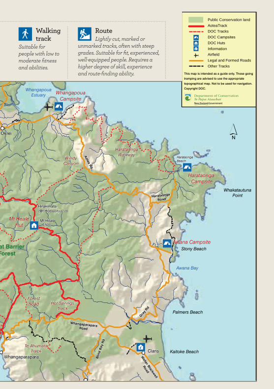
Public Conservation landAoteaTrackDOC TracksDOC CampsitesDOC HutsInformationAirfieldLegal and Formed RoadsOther Tracks
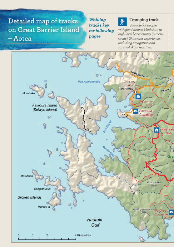
Detailed map of tracks on Great Barrier Island – Aotea
Walking tracks key for following pages
Tramping trackSuitable for people
with good fitness. Moderate to high level backcountry (remote areas). Skills and experience, including navigation and survival skills, required.
13
HaurakiGulf
Kaikoura Island(Selwyn Island)
Great BarrierForest
Okiwi
Claris
Okupu
Whangaparapara
Port
Fitz
roy
Kiwiriki Bay
Port Abercrombie
Stony Beach
Awana Bay
WhangapouaEstuary
Awana Campsite
WhangapouaCampsite
Akapoua Campsite
The Green Campsite
WhakatautunaPoint
Palmers Beach
Kaitoke Beach
Motuhaku
Broken Islands
Motutaiko
Rangiahua Is.
Mahuki Is.
Karaka Bay Rd
Aotea Rd
Aotea R
d
Port Fitzroy
WhangaparaparaRoad
Blin
d B
ay R
d
Gray
Rd
Harataonga
Road
Harataonga Campsite
Harataonga Beach
Walter Blackw
ell
Road
Hirakimata(Mt Hobson) 621m
Mt Heale
Whangaparapara309m
Maungapiko280m
Mt HealeHut
KaiaraaraHut
WindyCanyon
Hot SpringsTrack
WarrensTrack
Old LadyTrack
Te AhumataTrack
Forest Rd
ForestRoad
HarataongaWalkway
0 2 41 Kilometres
510m
This map is intended as a guide only. Those going
tramping are advised to use the appropriate
topographical map. Not to be used for navigation.
Copyright DOC.
Public Conservation landAoteaTrackDOC TracksDOC CampsitesDOC HutsInformationAirfieldLegal and Formed RoadsOther Tracks
RouteLightly cut, marked or
unmarked tracks, often with steep grades. Suitable for fit, experienced, well-equipped people. Requires a higher degree of skill, experience and route-finding ability.
Walking track
Suitable for people with low to moderate fitness and abilities.
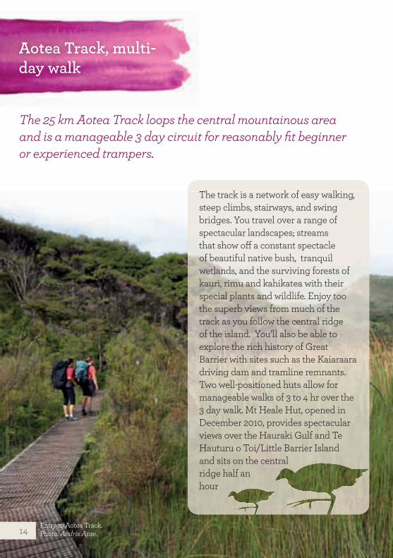
Aotea Track, multi-day walk
The 25 km Aotea Track loops the central mountainous area and is a manageable 3 day circuit for reasonably fit beginner or experienced trampers.
The track is a network of easy walking, steep climbs, stairways, and swing bridges. You travel over a range of spectacular landscapes; streams that show off a constant spectacle of beautiful native bush, tranquil wetlands, and the surviving forests of kauri, rimu and kahikatea with their special plants and wildlife. Enjoy too the superb views from much of the track as you follow the central ridge of the island. You’ll also be able to explore the rich history of Great Barrier with sites such as the Kaiaraara driving dam and tramline remnants.Two well-positioned huts allow for manageable walks of 3 to 4 hr over the 3 day walk. Mt Heale Hut, opened in December 2010, provides spectacular views over the Hauraki Gulf and Te Hauturu o Toi/Little Barrier Island and sits on the central ridge half an hour
Entry to Aotea Track. Photo: Andris Apse.14
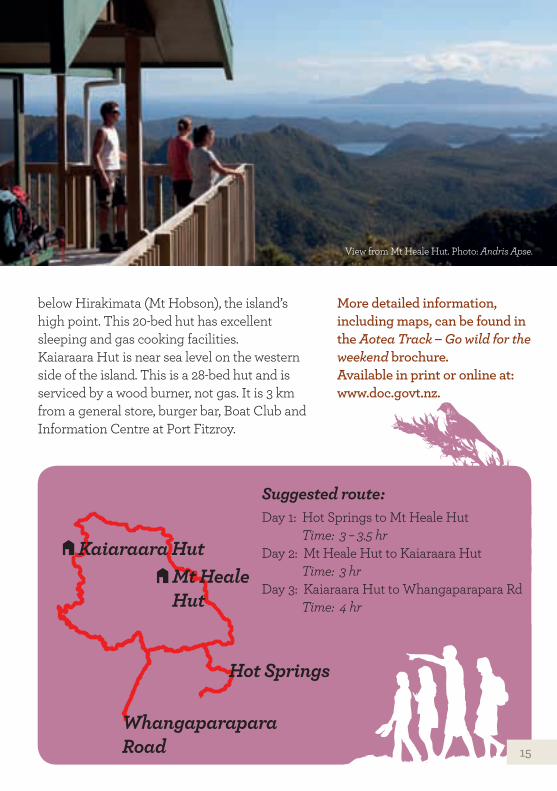
Suggested route:Day 1: Hot Springs to Mt Heale Hut Time: 3 – 3.5 hrDay 2: Mt Heale Hut to Kaiaraara Hut Time: 3 hrDay 3: Kaiaraara Hut to Whangaparapara Rd Time: 4 hr
More detailed information, including maps, can be found in the Aotea Track – Go wild for the weekend brochure. Available in print or online at: www.doc.govt.nz.
below Hirakimata (Mt Hobson), the island’s high point. This 20-bed hut has excellent sleeping and gas cooking facilities.Kaiaraara Hut is near sea level on the western side of the island. This is a 28-bed hut and is serviced by a wood burner, not gas. It is 3 km from a general store, burger bar, Boat Club and Information Centre at Port Fitzroy.
View from Mt Heale Hut. Photo: Andris Apse.
Hot Springs
Mt Heale Hut
Kaiaraara Hut
Whangaparapara Road 15
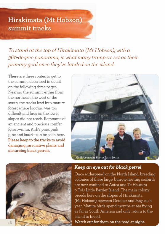
To stand at the top of Hirakimata (Mt Hobson), with a 360-degree panorama, is what many trampers set as their primary goal once they’ve landed on the island.
Hirakimata (Mt Hobson) summit tracks
There are three routes to get to the summit, described in detail on the following three pages.Nearing the summit, either from the northeast, the west or the south, the tracks lead into mature forest where logging was too difficult and fires on the lower slopes did not reach. Remnants of an ancient and precious conifer forest—rimu, Kirk’s pine, pink pine and kauri—can be seen here.Please keep to the tracks to avoid damaging rare native plants and disturbing black petrels.
Keep an eye out for black petrelOnce widespread on the North Island, breeding colonies of these large, burrow-nesting seabirds are now confined to Aotea and Te Hauturu o Toi / Little Barrier Island. The main colony breeds here on the slopes of Hirakimata (Mt Hobson) between October and May each year. Mature birds spend months at sea flying as far as South America and only return to the island to breed. Watch out for them on the road at night.
Mt Hobson trig. Photo: Terry Smith.
Blac
k pe
trel
. Pho
to: H
alem
a Ja
mie
son.
16
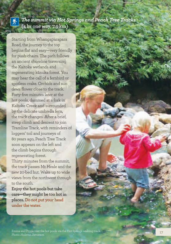
The summit via Hot Springs and Peach Tree Tracks (4 hr one way, 7.9 km)
Starting from Whangaparapara Road, the journey to the top begins flat and easy—very friendly for push-chairs. The path follows an ancient shoreline traversing the Kaitoke wetlands and regenerating kānuka forest. You may hear the call of a fernbird or spotless crake. Orchids and sun dews flower close to the track.Forty-five minutes later at the hot pools, dammed at a fork in Kaitoke Creek and surrounded by the delicate umbrella fern, the track changes. After a brief, steep climb and descent to join Tramline Track, with reminders of loggers’ toil and journeys of 80 years ago, Peach Tree Track soon appears on the left and the climb begins through regenerating forest.Thirty minutes from the summit, the track passes Mt Heale and the new 20-bed hut. Wake up to wide views from the northwest through to the south.Enjoy the hot pools but take care—they might be too hot in places. Do not put your head under the water.
Emma and Pippa visit the hot pools via the Hot Springs walking track. Photo: Halema Jamieson.
17
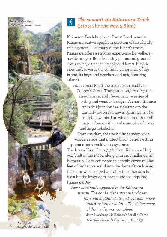
Kaiaraara Track begins at Forest Road near the Kaiaraara Hut—a spaghetti junction of the island’s track system. Like many of the island’s tracks, Kaiaraara offers a striking experience for walkers— a wide array of flora from tiny plants and ground cover to large trees in established forest, historic sites and, towards the summit, panoramas of the island, its bays and beaches, and neighbouring islands.
From Forest Road, the track rises steadily to Cooper’s Castle Track junction, crossing the
stream in several places using a series of swing and wooden bridges. A short distance from this junction is a side-track to the partially preserved Lower Kauri Dam. The track below this dam winds through semi-mature forest with good examples of tōwai
and large kohekohe.From the dam, the track climbs steeply via
wooden steps that protect black petrel nesting grounds and sensitive ecosystems.
The Lower Kauri Dam (1.5 hr from Kaiaraara Hut) was built in the 1920s, along with six smaller dams higher up. Logs estimated to contain seven million feet of timber were slid into the dams. Once loaded, the dams were tripped one after the other so a full blast hit the lower dam, propelling the logs into Kaiaraara Bay.
I saw what had happened to the Kaiaraara stream. The banks of the stream had been
torn and mutilated. Its bed was four or five times its former width . . . The defacement of that valley was complete. John Mowbray, Mt Hobson’s Scroll of Fame, The New Zealand Observer, 18 July 1931.
The summit via Kaiaraara Track (3 to 3.5 hr one way, 5.6 km)
Cooling off. Photo: Halema Jamieson.
Boulders Crossing. Photo: Halema Jamieson.
Kaur
i dam
. Ph
oto:
Des
Cas
ey.
18
The summit via Kaiaraara Track (3 to 3.5 hr one way, 5.6 km)
The summit via Windy Canyon and Palmer’s Track (2.5 to 3 hr one way, 3.3 km)
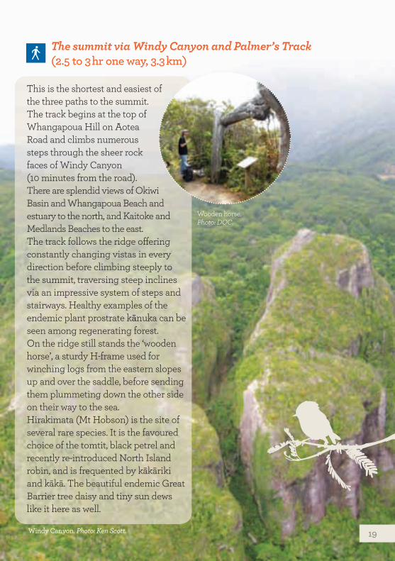
This is the shortest and easiest of the three paths to the summit. The track begins at the top of Whangapoua Hill on Aotea Road and climbs numerous steps through the sheer rock faces of Windy Canyon (10 minutes from the road). There are splendid views of Okiwi Basin and Whangapoua Beach and estuary to the north, and Kaitoke and Medlands Beaches to the east. The track follows the ridge offering constantly changing vistas in every direction before climbing steeply to the summit, traversing steep inclines via an impressive system of steps and stairways. Healthy examples of the endemic plant prostrate kānuka can be seen among regenerating forest.On the ridge still stands the ‘wooden horse’, a sturdy H-frame used for winching logs from the eastern slopes up and over the saddle, before sending them plummeting down the other side on their way to the sea.Hirakimata (Mt Hobson) is the site of several rare species. It is the favoured choice of the tomtit, black petrel and recently re-introduced North Island robin, and is frequented by kākāriki and kākā. The beautiful endemic Great Barrier tree daisy and tiny sun dews like it here as well.
Windy Canyon. Photo: Ken Scott.
Wooden horse. Photo: DOC.
19
Whangaparapara area tracks
Whangaparapara was the setting for several early industries. Within its harbour are the remains of a whaling station and a sawmill that processed logs from as far away as Northland and the Coromandel. A steam engine, chimney stack and stone walls remain. Like many of the island’s western bays, Whangaparapara was also an outlet for kauri logs.
Tramline Track (6 hr one way) The Tramline Track system (see also page 23), which extends about 8 km from
Whangaparapara to Aotea Road, traverses most of the island at its widest point. The Whangaparapara end of the track progresses over several bridges before joining Pack Track and Forest Road (1 hr).
Pack Track (1–1.5 hr one way) This track loops between two points on Forest Road and gives a taste of several
different terrains—the tramline, steep inclines and rejuvenating forest, including dense stands of young kauri.
Withey’s Track (1.5 hr one way)
Named after Bill Withey, who was a steam hauler operator for the Kauri Timber Company, Withey’s Track links with the Pack and Tramline Tracks forming a round hike from Whangaparapara. Branching off Tramline Track, it climbs steadily before dropping to Wairahi Stream, crossing three times (no bridges) before linking with Pack Track. Beautiful bush and stream views.
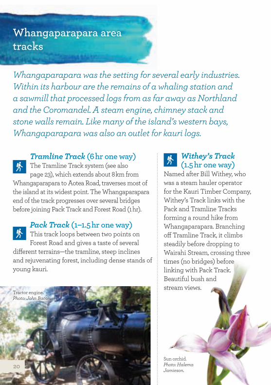
Tractor engine. Photo: John Bacon.
Sun orchid. Photo: Halema Jamieson.
20
Mount Whangaparapara and Old Mill Tracks (both 2 hr return) These tracks each take 2 hr return and
begin close to Whangaparapara Road and travel through rejuvenating bush. The climb to the mount is steep. Old Mill Track follows the edge of mangroves to The Green campsite (15 minutes), before crossing two steep spurs and descending to the site of the Kauri Timber Company sawmill and a historic steam traction engine. At low tide, the track can be walked around the shoreline, beginning at The Green campsite.
Te Ahumata Track (1 hr one way)
This track follows an old mining road between Whangaparapara and Blind Bay roads. From either end a 30 minute gradual climb leads to a junction, where a branch track (a further 30 minutes) leads to the summit covered with wind-shorn, bonsai-like native plants and numerous orchid species. There are panoramic views in every direction. The main track is administered by Auckland Council and the branch track by the Department of Conservation.
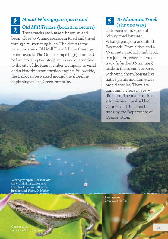
Whangaparapara Harbour with the old whaling station and the site of the saw mill in the background. Photo: D. Walker.
Copper skink. Photo: Halema Jamieson.
Green gecko. Photo: Sven Stellin.
background.
21
Warren’s and Bridle Tracks (1 hr one way)
One kilometre from Port Fitzroy, Warren’s Track is a gently graded climb to a waterfall, the stream offering deep pools good for swimming. It continues on through kauri plantation before joining Bridle Track, which leads to the Fitzroy store. An easy grade through indigenous and exotic forest, this track is an alternative to walking the road.
One kilometre from Port Fitzroy, Warren’s Track is a gently graded climb to a waterfall, the stream offering deep pools good for swimming. It continues on through kauri plantation before joining Bridle Track, which leads to the Fitzroy store. An easy grade through indigenous and exotic forest, this track is an alternative to walking the road.
Port Fitzroy area tracks
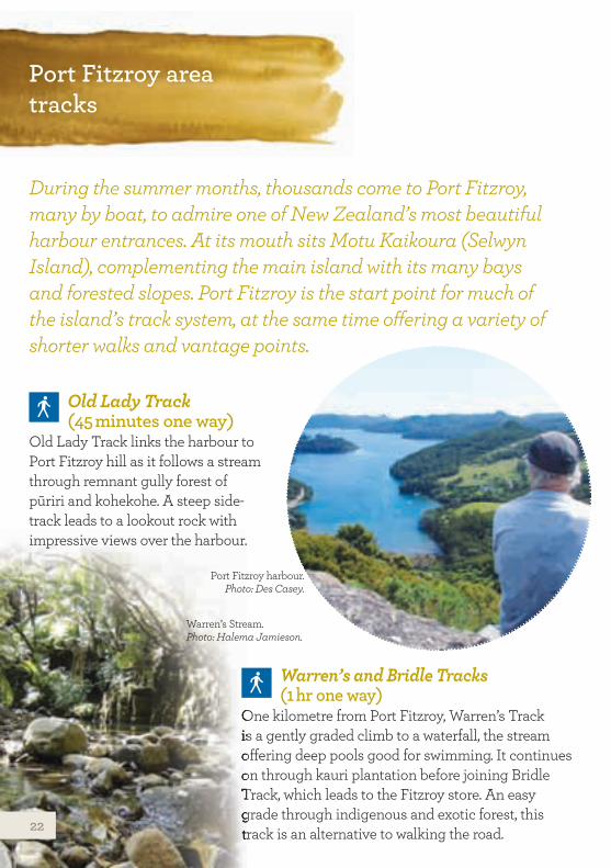
During the summer months, thousands come to Port Fitzroy, many by boat, to admire one of New Zealand’s most beautiful harbour entrances. At its mouth sits Motu Kaikoura (Selwyn Island), complementing the main island with its many bays and forested slopes. Port Fitzroy is the start point for much of the island’s track system, at the same time offering a variety of shorter walks and vantage points.
Old Lady Track (45 minutes one way)
Old Lady Track links the harbour to Port Fitzroy hill as it follows a stream through remnant gully forest of pūriri and kohekohe. A steep side-track leads to a lookout rock with impressive views over the harbour.
Port Fitzroy harbour. Photo: Des Casey.
Warren’s Stream. Photo: Halema Jamieson.
22
Line W Track (1 hr one way)
This track branches off Kiwiriki Track to join directly with Forest Road, enabling a much shorter round trip from, and back to, the Kaiaraara Hut, without having to go to Maungapiko.
South Fork Track (3 hr one way)
Beginning 1 km south of Kaiaaraara Hut, South Fork Track follows an old bridle track. It crosses the stream twice, then climbs steadily to a swing bridge on the way to the central ridge. It travels through regenerating forest with excellent examples of tutu.
Forest Road (5 hr one way)
Thirteen kilometres in length and once criss-crossed with forestry tracks, Forest Road is a popular trek for both trampers and mountain bikers, providing a wide array of beautiful bush and mountain views.
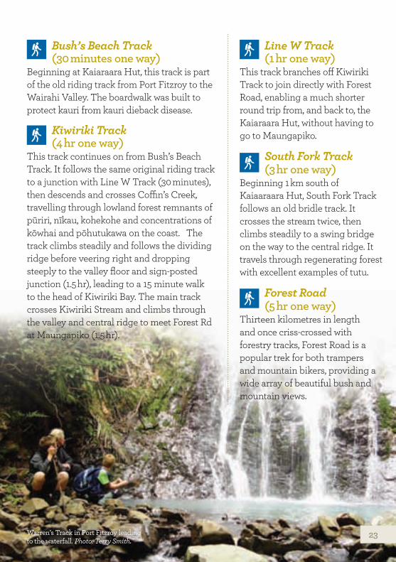
Warren’s Track in Port Fitzroy leading to the waterfall. Photo: Terry Smith.
Bush’s Beach Track (30 minutes one way)
Beginning at Kaiaraara Hut, this track is part of the old riding track from Port Fitzroy to the Wairahi Valley. The boardwalk was built to protect kauri from kauri dieback disease.
Kiwiriki Track (4 hr one way)
This track continues on from Bush’s Beach Track. It follows the same original riding track to a junction with Line W Track (30 minutes), then descends and crosses Coffin’s Creek, travelling through lowland forest remnants of pūriri, nīkau, kohekohe and concentrations of kōwhai and pōhutukawa on the coast. The track climbs steadily and follows the dividing ridge before veering right and dropping steeply to the valley floor and sign-posted junction (1.5 hr), leading to a 15 minute walk to the head of Kiwiriki Bay. The main track crosses Kiwiriki Stream and climbs through the valley and central ridge to meet Forest Rd at Maungapiko (1.5 hr).
23
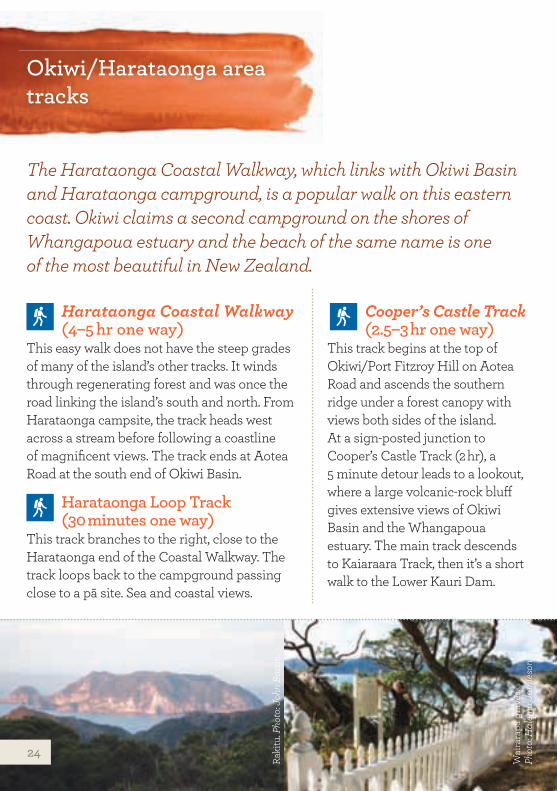
Okiwi/Harataonga area tracks
The Harataonga Coastal Walkway, which links with Okiwi Basin and Harataonga campground, is a popular walk on this eastern coast. Okiwi claims a second campground on the shores of Whangapoua estuary and the beach of the same name is one of the most beautiful in New Zealand.
Harataonga Coastal Walkway (4–5 hr one way)
This easy walk does not have the steep grades of many of the island’s other tracks. It winds through regenerating forest and was once the road linking the island’s south and north. From Harataonga campsite, the track heads west across a stream before following a coastline of magnificent views. The track ends at Aotea Road at the south end of Okiwi Basin.
Harataonga Loop Track (30 minutes one way)
This track branches to the right, close to the Harataonga end of the Coastal Walkway. The track loops back to the campground passing close to a pā site. Sea and coastal views.
Cooper’s Castle Track (2.5–3 hr one way)
This track begins at the top of Okiwi/Port Fitzroy Hill on Aotea Road and ascends the southern ridge under a forest canopy with views both sides of the island. At a sign-posted junction to Cooper’s Castle Track (2 hr), a 5 minute detour leads to a lookout, where a large volcanic-rock bluff gives extensive views of Okiwi Basin and the Whangapoua estuary. The main track descends to Kaiaraara Track, then it’s a short walk to the Lower Kauri Dam.
Raki
tu. P
hoto
: Joh
n Ba
con.
Wai
rara
pa g
rave
s.
Phot
o: H
alem
a Ja
mie
son.
24
Tramline Track (6 hr one way) The Tramline Track receives minimal
upkeep—for fit trampers only. From its northeastern beginning on Aotea Road, it follows the old tramline used by the Kauri Timber Company during the 1920s and 1930s. It is sometimes very steep and was a remarkable engineering feat of its time. It descends abruptly to Awana Stream and Waterfall before climbing steeply to a plateau and then dropping to Kaitoke Stream. The track crosses several creeks, crossing Forest Road and linking with the Whangaparapara tramline extension.
Burrill Route (8–9 hr return) Formed in the early 1970s as mining
access for copper, Burrill Route begins at Mabey’s Road. This route is named after the late Max Burrill, who farmed some of the northern parts of Aotea. It climbs steeply through the regenerating forest of Te Paparahi to the central ridge and follows through to Tataweka (526 m). The track is not regularly managed, is indistinct in some places and is for fit trampers only. No water is available on this route.
Te PaparahiTe Paparahi is of significant importance to Ngāti Rehua as it holds taonga and spiritual values of people, flora, fauna, land and water. It was also the last stronghold for kōkako on the island after the population plummeted to near extinction from predation and habitat loss. The last two kōkako were transferred to Te Hauturu o Toi/Little Barrier Island in 1994 with the hope that their
offspring will be brought back to
Aotea once predators
such as cats and rats are
controlled.
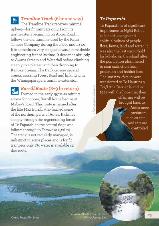
Okiwi. Photo: Ken Scott.
Phot
o: R
ogan
Col
bour
ne.
Pāteke on Burrills Drain, Okiwi. Photo: Joanna Sim.
25
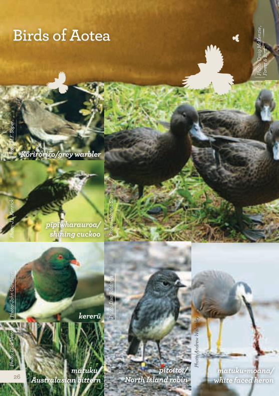
Birds of Aotea
mātātā/fernbird
pīpīwharauroa/ shining cuckoo pāteke/brown teal
Kōriroriro/grey warbler
kererū
pītoitoi/ North Island robin
matuku/ Australasian bittern kākāriki
matuku-moana/ white faced heron
Phot
o: L
isa
Ridd
ings
Phot
o: D
ick V
eitc
h
Phot
o: C
raig
McK
enzi
e ,
Fore
st &
Bird
Phot
o: J
.L. K
enric
kPh
oto:
M.F.
Sop
er
Phot
o: J
oann
a Si
m
Phot
o: J
ohn
Gar
dine
r
Phot
o: A
ndre
w W
alm
sley
26
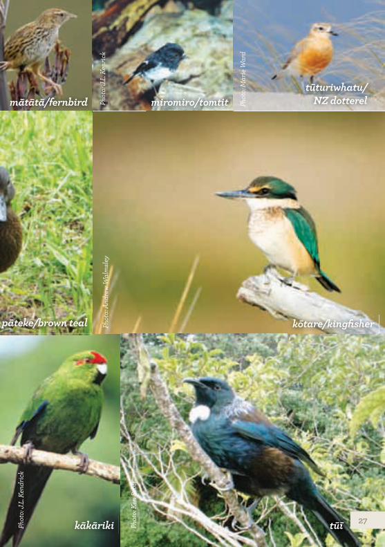
mātātā/fernbird miromiro/tomtittūturiwhatu/
NZ dotterel
kōtare/kingfisherpāteke/brown teal
tūīkākārikiPhot
o: J
.L. K
endr
ick
Phot
o: A
ndre
w W
alm
sley
Phot
o: J
.L. K
enric
k
Phot
o: M
arie
War
d
Phot
o: K
en S
cott
27
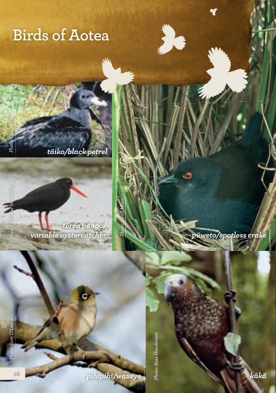
tāiko/black petrelPhot
o: C
raig
Pot
ton
Birds of Aotea
pūweto/spotless crakePhot
o: G
eoff
Moo
n
pihipihi/waxeye
Phot
o: S
am O
’Lea
ry
kākāPhot
o: R
oss H
ende
rson
tōrea pango/ variable oystercatcherPh
oto:
And
rew
Wal
msle
y
28
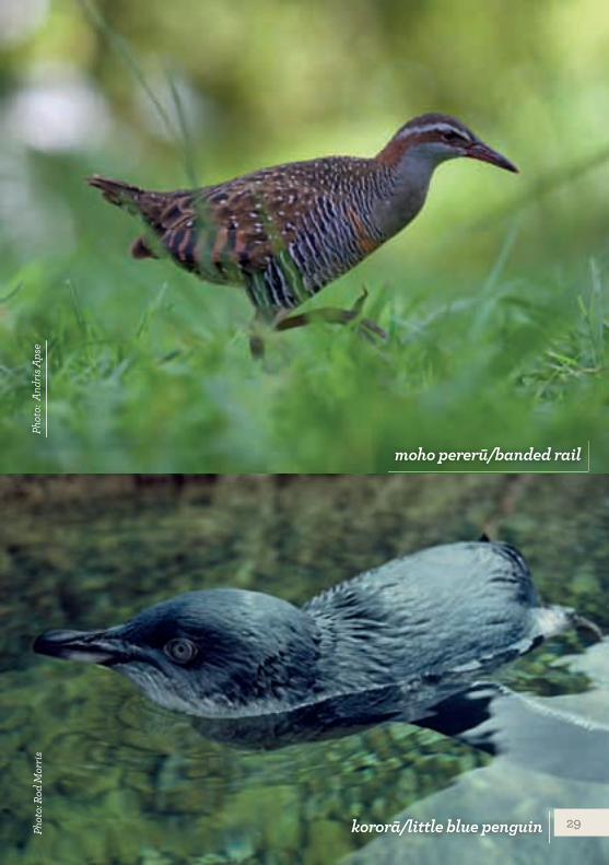
kororā/little blue penguinPhot
o: R
od M
orris
moho pererū/banded rail
Phot
o: A
ndris
Aps
e
29
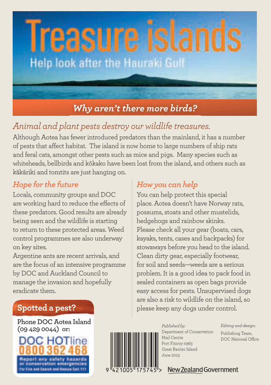
Animal and plant pests destroy our wildlife treasures. Although Aotea has fewer introduced predators than the mainland, it has a number of pests that affect habitat. The island is now home to large numbers of ship rats and feral cats, amongst other pests such as mice and pigs. Many species such as whiteheads, bellbirds and kōkako have been lost from the island, and others such as kākāriki and tomtits are just hanging on.
Hope for the futureLocals, community groups and DOC are working hard to reduce the effects of these predators. Good results are already being seen and the wildlife is starting to return to these protected areas. Weed control programmes are also underway on key sites.Argentine ants are recent arrivals, and are the focus of an intensive programme by DOC and Auckland Council to manage the invasion and hopefully eradicate them.
Why aren’t there more birds?
How you can helpYou can help protect this special place. Aotea doesn’t have Norway rats, possums, stoats and other mustelids, hedgehogs and rainbow skinks. Please check all your gear (boats, cars, kayaks, tents, cases and backpacks) for stowaways before you head to the island. Clean dirty gear, especially footwear, for soil and seeds—weeds are a serious problem. It is a good idea to pack food in sealed containers as open bags provide easy access for pests. Unsupervised dogs are also a risk to wildlife on the island, so please keep any dogs under control.Spotted a pest?
Phone DOC Aotea Island (09 429 0044) or: Published by:
Department of Conservation Mail Centre Port Fitzroy 0963 Great Barrier Island June 2013
Editing and design:
Publishing Team, DOC National Office
Recommended