GEOLOGICAL AND GEOCHEMICAL INVESTIGATIONS I N THE KYUQUOT AREA
Vancouver I s land Lat . 50010'N. - Long. 127O22'W.
Sevtember-October, 1971 N.T.S. 92/L/3W
December 1971 G . Harper


CANADA - 4 - [""'"lo] NATIONAL TOrOCRAfHIC SFRIF-5 1 5 0 W F ~ R T eomoV lh13 Ma0 as ""'ii'X ' ' ' P I L/l U F V
t i

- - -- - - -- -
- 5 -
body i n the area, coincident with one geochemical anomaly. Blocks
0 of claims were staked, i n MacDonald1s name, over severa l of the
geochemically anomalous areas which included a couple of h igh grade
z inc discoveries. The e a r l i e r block of claims was allowed t o lapse
i n favour of the l a t t e r , t o which one year ' s assessment work was
applied.
In January 1971 J. Schussler staked a block of claims,
adjoining the Syndicate's claims, which e f f ec t i ve ly cover a l l the
remaining geochemically anomalous areas , save f o r those on Can-Fer
ground t o the east . . A program of s o i l geochemistry, magnetometer
survey and geological mapping was proposed by MacDonald f o r t he
summer of 1971. However, due t o budget r e s t r i c t i o n s and complica-
t i ons over the Syndicate agreement, t h i s program was not undertaken.
4. PRESENT WORK
During l a t e September and ear ly October 1971, G . Harper
and prospector K. Christensen examined t he a rea , undertook l imited
(3 s o i l sampling and assessed t h e geological po t en t i a l . The investiga- t i o n s were centred on the in t rus ive and coincident l a rge s t geochemical
I anomaly. Exposure has been subs tan t ia l ly improved i n the l a s t twelve
months by a network of new logging roads. No s ign i f i c an t copper
mineralization or a l t e r a t i on features were discovered. Considerable
p y r i t e but only t races of chalcopyrite, malachite, galena and
spha l e r i t e were noted i n t h e v i c i n i t y of t he main north-northwesterly
f a u l t .
B horizon s o i l samples col lected along a l l t he roads i n the
a rea were analysed f o r copper, zinc, molybdenum, s i l v e r and lead.
These elements showed a high background throughout t he a rea - e f f ec t i ve ly regardless of bedrock type. The only anomalies a re
s ing le sample highs.
5. LOCATION AND CLAIM STATUS
The property a t present comprises 91 mineral claims. These
0 a re d i s t r ibu ted as shown i n Fig. 1, up the Easy Creek - upper Malksope

- 6 -
River va l l ey . Fif ty-five mineral claims i n four claim groups
0 (B.P., EASY, ON and B.W. claim groups) were staked by and recorded
i n t h e name of Earl D. Dodson of MacDonald Consultants. The SNOW
1-36 mineral claims i n the SNOW claim group were staked and
recorded i n the name of John Schussler.
6. ACCESS
In the pas t , access has generally been by f l o a t plane t o
e i t h e r Malksope o r Easy I n l e t . An interconnecting system of logging
roads runs up both these creeks. Trai lb ikes , backpacking o r r i de s
with t he logging company t rucks have been used t o ge t from tidewater
t o t h e t a r g e t areas. In September-October 1971 access was by h e l i -
copter , but invest igat ions have shown t h a t a surface rou te i s
pe r f ec t l y feas ib le . Good logging roads from Gold River t o Fa i r
Harbour can be driven a t n igh t s o r weekends with t he permission o f :
M r . D. Brealey C.F.P./C.Z. Road System Administrator North Is land Agencies Ltd.
6 $ G /
6-942 Island Highway P.O. Box 909 Campbell River, B. C .
I From Fa i r Harbour it i s only a 20-mile boat t r i p through
she l t e r ed Kyuquot Sound t o Easy I n l e t . If it i s intended t o t ake a
t ruck over t o the Peninsula, t h i s can be done using a Landing Craft
which takes supplies from Fa i r Harbour t o Kyuquot Vi l lage . This
landing c r a f t meets the Island Freighter a t Fa i r Harbour every
Sunday afternoon .
The logging company operating under contract t o Tahsis Co.
i n t h e Peninsula area is :
F r i e l l Lake Logging Co. Ltd. 815 West Hastings S t r e e t Vancouver 1, B. C.
The owner is Rudy Deering, and t he f i e l d superintendent is Bob Bell .
C i
- - -

I ~ - 7 -
0 7. GEOLOGY
(a) General Outline
The port ion of t he Kyuquot Peninsula under consideration
i s underlain chief ly by sedimentary and volcanic rocks which are
thought t o belong t o the Bonanza Group. The Lower Bonanza Group
cons i s t s predominantly of calcareous sediments including l i g h t and
dark limestones with in te rca la ted volcanics, a r g i l l i t e s and skarns.
The Upper Bonanza i s predominantly volcanic and includes both i n t e r -
mediate flows and intermediate t o acid pyroc las t i cs . The Bonanza
Group rocks i n t h i s area generally dip t o t he southeast , south o r
southwest a t between 2S0 and SO0.
In t he v i c i n i t y of Kashutl I n l e t , t h e Bonanza rocks have
been intruded by a medium-grained syenodiori te plug. In t h e v i c i n i t y
of t he Malksope River the s t r a t a a r e cut by a minor quartz porphyry
in t rus ion. The age re la t ionsh ip between these two in t rus ions is not
c lea r .
0 The area i s transected by a major northwest trending f a u l t
zone. This i s e i t h e r the southward extension of t he Mahatta Fault
I s l i g h t l y o f f se t ; o r a p a r a l l e l f a u l t .
The various claim blocks a r e located over areas where:
(1) prospecting i n 1970 revealed mineralization and (2) where s i l t
samples indicated geochemical anomalies. The EASY claims were
s i t e d t o cover a zone with widespread but minor chalcopyrite and
p y r i t e . The sulphides a r e associated with quar tz veins i n both
volcanics and sediments. The SNOW claims adjoin t he EASY claims t o
t h e north and cover the north end of a l a rge geochemical anomaly.
A quar tz eye porphyry body with minor disseminated p y r i t e , outcrops
within these claims.
The ON claims were located t o cover an extensive skarn
zone containing minor disseminated spha l e r i t e .
The BP claims cover a showing with chalcopyrite, hematite
0 and magnetite i n a shear zone i n dark calcareous sediments. The BW
claims were located t o cover an exposure of dark green andesite
containing minor disseminations and ve in l e t s of chalcopyrite.
- -


- -
- 9 -
0 Mapping
The object of the work undertaken i n September - October
1971 was t o assess the merit and po t en t i a l of t h e ground i n and
around t h e claim blocks. ~ t t e n t i o n was di rected a t t h e i n t ru s ive
body. To t h i s end Harper undertook: (1) de t a i l ed geological
mapping of se lected t raverses , l a rge ly along newly-cut roads ;
(2) reconnaissance and check mapping of some of t he areas recce.
mapped i n 1970 by MacDonald; (3) reconnaissance of t h e in t rus ive
. e a s t onto t he adjoining Bralorne Can-Fer claims; (4) inves t iga t ion
of t he most s ign i f ican t showing i n t he a rea -- namely t h e Bralorne
Can-Fer chalcopyrite/pyri te mineralized zone. Christensen ca r r ied
out prospecting and geochemical sampling.
(c) Lithology
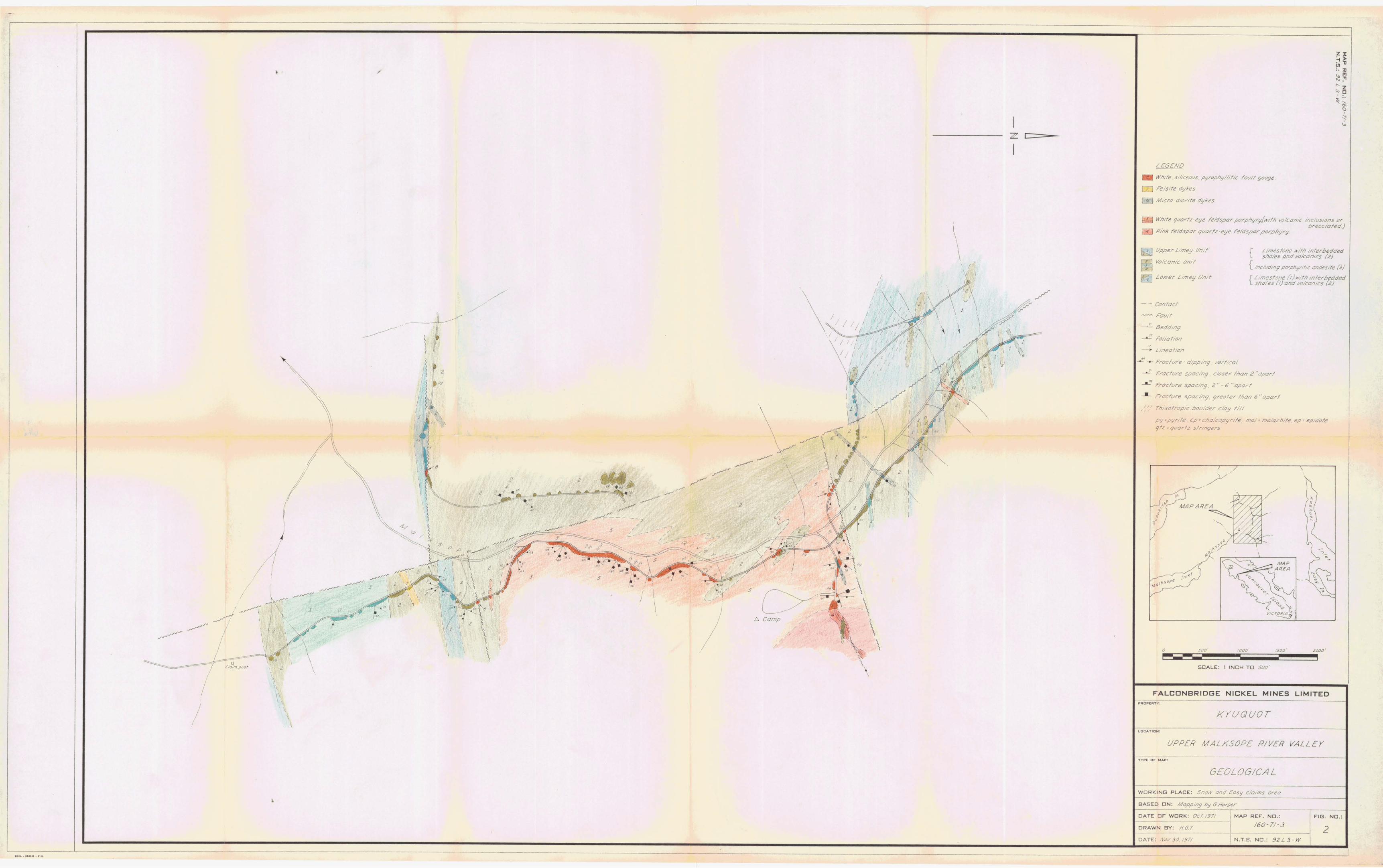
The d i s t r ibu t ion of rock types i n t he cen t ra l a rea and
t h e i r in fe r red s p a t i a l r e la t ionsh ips a r e shown i n Figs. 2 and 3.
The var ious rock un i t s recognized a r e described below. 0 i ) The Lower Limey Unit
I This is an extremely var iab le u n i t . Rock types included are : massive white limestone, well bedded purple - hematite
r i c h limestone, bedded purple limestone with interbedded
ferruginous shale' bands (k" every 2" - 6") , purple and green
limey shales and greywackes. The shaley rocks tend t o occur
as lenses within the purer limestones. In te rca la ted with
these sediments are cryptocrys t a l l i n e , dark green, massive
volcanic rocks; probably l a rge ly tuffaceous. Colour on t he
Munsell Colour Chart va r i e s from 5GY5/2 t o 10GY6/4.
Exposure i s generally poor, due la rge ly t o t h e ease with
which these s o f t rocks weather. Consequently contacts between
bands and lenses are f requent ly obscured o r so deeply weathered
a s t o be of l i t t l e i n t e rp re t a t i ve value. I t appears though
t h a t limestone i s t he dominant rock type and t h a t t h e sequence
0 was deposited under v io l en t condit ions. Contacts between t u f f s
and limestones, where v i s i b l e , show flame s t ruc tu r e s and small
-- - - - - -

- l o -
0 sca le slumping. Large (up t o 20' across) pillow-like, sp i r a l l y -
layered blocks of t u f f surrounded by limestone a re be s t explained
as having formed by accret ion while r o l l i n g o r s l i d i n g down a
tu rb id slump slope. The converse, blocks of limestone surrounded
by volcanics a l so occur.
Disseminated fine-grained py r i t e , forming up t o 3% of t he
rock, occurs patchi ly through t h e white limestone, but i s very
r a r e elsewhere. There a re a l so sporadic minute vugs containing
galena i n the white limestone. Limonite and p y r i t e a r e developed
on f rac tures adjacent t o f a u l t s .
i i ) The Volcanic Unit
Theproportionof green t u f f s i n t h e limey u n i t increases
rapidly towards t he top. Where no fu r the r limestone beds a r e
v i s i b l e i s considered t he top of the limey u n i t and base of the
volcanic un i t . They a r e e s sen t i a l l y conformable.
The majority of t he u n i t is crypto-crysta l l ine , dark green,
0 massive, tuffaceous volcanics. In t h e few places where grains
a re v i s i b l e the composition is t h a t of a dac i t e . E i ther i n t e r -
bedded o r as wide dyke in t rus ions through t h i s u n i t and the
lower limey u n i t are porphyr i t i c andesi tes . These a r e greyish
green, massive, fine-grained t o crypto-crysta l l ine rocks
(colour on the Munsell Chart is 10GY6/2). A l l through a r e 10%-
15% of 2 - 5 mm long, anhedral, black, hornblende phenocrysts.
These are uniformly d i s t r i bu t ed through t he rock, as a re a l so
3 - 5 mm vugs f i l l e d o r l ined with epidote. These epidote vugs
are presumed t o be of secondary or ig in .
Outcropping i n t h e extreme nor th i n o r through the lower
limey un i t is one zone of a modified form of t h i s andesite.
In addit ion t o the hornblende phenocrysts a r e 5%-7% of uniformly
d i s t r ibu ted 2 - 5 rnm ves icu la r z eo l i t e s . These ves ic les contain
rad ia t ing fibrous c r y s t a l s of white - pa le pink zeo l i t e . The
zeo l i t es are probably of secondary, low temperature o r ig in .
0 There i s i n su f f i c i en t evidence t o confirm t h e extrus ive o r
- ----- - - -

- l1 -
0 i n t r u s ive nature of these porphyr i t i c andesi tes . From t h e i r
wide extent , though, it is l i k e l y t h a t they a r e ex t rus ive flows
interbedded with the tuffaceous rocks.
Patchi ly the j o in t s i n the volcanics contain abundant
hemati te. Limonite a f t e r p y r i t e is widespread on j o i n t s .
Disseminated py r i t e was no t observed anywhere i n t he volcanics.
The only copper minerals observed were very occasional small
f l e c k s of malachite on random jo in t planes.
i i i ) The Upper Limey Unit
This u n i t i s extremely s imi la r t o the lower limey u n i t .
Its var ied s u i t e of limestone, sha les and volcanics outcrop t o
t he south of the i n t ru s ive . Its lower contact is imperceptibly
gradat ional up from the volcanic u n i t . The only di f ference
from the lower limey u n i t is t h e g rea te r proport ion of volcanics
and lower proportion of limestones. Otherwise a l l descr ip t ions
from (a) hold good.
O i v ) Dykes
Several v a r i e t i e s of dykes have been mapped, but i t i s
thought t h a t most a re of s im i l a r o r ig in , r e l a t ed e i t h e r t o t he
volcanic o r in t rus ive phases.
The most common type o f dyke i s a pa le green, white and
black, very fine-grained microdior i te . These dykes a r e wide-
spread throughout i n t ru s ive s , sediments and volcanics. The
dykes a re generally 10' - 20' wide, s t r i k e 055' - 080' and d ip
v e r t i c a l l y . They have sharp contacts with very narrow o r
v i r t u a l l y non-existent c h i l l e d margins. The microdior i te i s
uniformly grained and cons i s t s e s s e n t i a l l y of '60% white t o
pa l e green fe ldspar , 3 0 % black pyroxene o r amphibole and up t o
10% of pale green quartz g ra ins . The rock general ly appears
f r e s h and unal tered. No disseminated sulphides were observed
i n it. Only minor l imonite was developed on some f r a c t u r e
0 planes.

- 12 -
0 A s ingle example of a f e l s i t e dyke occurs near the south
end of the mapped area. Its contacts a r e not exposed and
therefore i t s a t t i t u d e i s unknown. I t has an exposed width of
near ly 100 f ee t . The rock is aphani t ic and appears t o be
predominantly quartz. The white colour i s pa tch i ly s ta ined
brown by limonite which is qu i te abundant on j o in t s . There a r e
no phenocrysts i n the rock. The name f e l s i t e is used i n a non-
spec i f i c sense t o describe t he general nature and presumed
composition of the rock.
A dyke o f quartz eye fe ldspar porphyry occurs i n t h e nor th .
This rock is e s sen t i a l l y the same as the main quartz eye fe ldspar >
porphyry in t rus ive mass. I t s t r i k e s about 040° and dips ver t -
i c a l l y through volcanics. Other outcrops of the porphyry,
in t ruding volcanics but c lose r t o the i n t ru s ive contact , can be
in te rpre ted e i t h e r as dykes o r apophyses of t he i n t ru s ive . The
descr ipt ion of the main in t rus ive is applicable t o these dyke-
l i k e outcrops.
c d A narrow zone of leached-looking aphani t ic quar tz , spot ted
through with pyrophyll i te , occurs a s a f a u l t zone f i l l i n g i n t he
southwest.
v) The Quartz Eye Feldspar Porphyry In t rus ive
This, t he only in t rus ive i n the mapped area , l i e s largely
west of the Malksope River. I t is bounded i n p a r t by f a u l t s
and i n pa r t has a gradational in t rus ive contact with t h e s t r a t i -
graphic sequence which is mainly volcanics i n the area of the
in t rus ive . As the volcanics contact is approached there a re
increasing numbers of smoothly rounded - 6"-20'+ across - included fragments of volcanics. The contacts of these volcanic
inclus ions a re abrupt and they do not have broad ch i l l ed margins.
In the immediate v i c i n i t y of the 'contact the increase i n included
volcanics has proceeded t o the point where the rock i s a l l
0 volcanics, except f o r minor s t r i n g e r s and lenses of porphyry
f i l l i n g weak s t ruc tu r a l zones i n t he volcanics.
. . '"> . - ,. . ' ?

- - - -- - -
- 13 -
0 In places the i n t ru s ive with included lenses of volcanics
has a brecciated appearance. I t i s apparently no t breccia ted
though, j u s t lenses of volcanics assimilated during in t rus ion .
I n contras t , brecciated mater ia l was recognized i n t he v i c i n i t y
of the main north-northwest t rending f a u l t . Here t h e g ran i te
no t only contained some more angular blocks of volcanics , but
a l s o contained blocks of porphyry.
The porphyry does not vary much throughout t h e a rea . Two
types are mapped, one containing a l l white and t he o ther
p a r t l y pink feldspar. These were the only not iceable d i f f e r -
ences. The rock has a pa l e grey o r off-white colour. On the
weathered surface, 1 - 2 cm long oval quartz eyes a r e recog-
nizable, but they a re not d is t inguishable on f r e sh ly broken
surfaces from the overa l l high quartz content . Some 70%-80%
of t h e rock i s medium- t o coarse-grained (5 - 10 mm) quar tz
g ra ins , through which a r e sca t t e red 10%-20% of s im i l a r s ized
white c a l c i c o r white c a l c i c p lus some pink potash fe ldspar
0 grains . Uniformly d i s t r i b u t e d through a l so a r e f i n e r grained 2 - 5 mm aggregates o f dark green hornblende c r y s t a l s . In
patches the re a re p y r i t e c ry s t a l s forming nuc le i t o these
hornblende gra ins . Minor l imonite/goethite occurs on random
f r ac tu r e planes.
(d) Fracturing
No pronounced s e t s of c losely spaced j o in t s , e i t h e r with
o r without cupriferous minerals, were observed. What pervasive
f r a c t u r e s t h a t do occur tend t o s t r i k e e a s t t o nor theas t o r north-
northwest. The l a t t e r t rend p a r a l l e l s t he major f a u l t through the
area . The former s e t a l igns with geological boundaries and a
second f a u l t d i rec t ion . Nowhere a r e the f r a c tu r e s in tense ly
developed.
(e) S t ruc tu re
0 A body of quartz eye fe ldspar porphyry has intruded a
succession of interbedded limey sediments and volcanics t h a t now
d ip gent ly t o moderately t o t h e SSE - SSW.
-- -- - - - -

- 14 -
0 Dykes have intruded both porphyry and s t r a t a .
The lack of ch i l l ed margins between volcanic inclus ions
and theporphyrysuggests t h a t the whole environment was a t a h igh
temperature during in t rus ion. In t rus ion was probably synorogenic,
equating closely i n time with extrusion of t he volcanics. The dykes
a r e e i t h e r v i r t u a l l y i den t i ca l t o t he porphyry o r a r e f i n e r grained
( in the case of the d io r i t e ) , intermediate between the in t rus ive and
extrus ives . The dykes are probably l a t e s tages of t h i s igneous phase.
Although the in t rus ive is r e s t r i c t e d i n exposure t o ea s t of
t h e main NNW fau l t ; it appears t o t rend ENE p a r a l l e l t o t he dykes,
and t he s t r i k e of t he s t r a t a . - Two 4 E ~ : ~f f a u l t s - both v e r t i c a l - a re developed. A s e t
on which there is no more than minor displacement t rends ENE. These
a r e characterized by shear zones o r narrow - 20'-30' - zones of
s i l i c eous pyrophyl l i t i c f a u l t gouge.
The second f a u l t d i rec t ion t rends NNW. This is t he trend
0 of several major f a u l t s on Vancouver Is land. A f a u l t on t h i s t rend
running r i g h t down t h e upper Malksope River Valley and on down the
Easy Creek Valley i s inferred from s igns of a l t e r a t i o n and breccia-
t i o n i n rocks i n close proximity. This NNW f a u l t has displaced the
ENE f a u l t s .
(f) A1 t e r a t ion
No evidence was found t o ind ica te a s i gn i f i c an t halo of
a l t e r a t i o n as generally occurs around porphyry copper deposi ts .
Al tera t ion of any s o r t was l imi ted. Minor pyrophyl l i te was observed
i n a f a u l t zone i n t he southwest. Epidote is weakly developed
through t he volcanics. Moderate amounts of l imonite and i n places
goe th i te occur throughout t he volcanics and i n t ru s ive s . Hematite
is very loca l ly developed i n t h e volcanics. Carbonate s t r i nge r s
a r e abundant through the volcanics adjacent t o t he limestone horizons
but lacking elsewhere. Quartz veins a r e not abundant anywhere.
0
-
- 15 -
(g) Mineralization
0 The minor amounts of copper minerals, chalcopyrite and
malachite, found by e i t h e r t he present workers o r MacDona1d1s 1970
prospecting crew, are of no si.grrificance. They apparently represent
no more than the random t r ace s invar iably found i n such rock types
when prospected hard enough. The cupriferous occurrences i n the
volcanics are a l l on f rac ture planes, whereas i n t he in t rus ives
very occasional fine-grained specks of disseminated chalcopyrite
occur with the more widespread disseminated p y r i t e . Disseminated
p y r i t e forms up t o 3% of t he quartz eye fe ldspar porphyry i n large
(hundreds of f e e t across) patches concentrated i n the northwest
corner of the porphyry body.
Prospecting the extension of t he in t rus ive t o t he ea s t
onto t he Bralorne Can-Fer claims did not y i e ld other a reas of
porphyry containing disseminated sulphides. I t the re fore seems
l i k e l y t h a t the py r i t e i s a loca l concentration r a t h e r than pa r t of
a l a rge p y r i t i c halo extending t o the ea s t . I f it is j u s t a local ?f 3 " concentration, then i t s locat ion i s possibly control led by t he ea s t -
nor theaster ly f a u l t immediately t o t he north. To t he e a s t , Bralorne
Can-Fer's main showing i s a shear zone with abundant, i n places
massive, chalcopyrite and p y r i t e developed along a shor t sect ion of
t h i s f a u l t . The Bralorne Can-Fer zone was subsequently cut by a
barren microdiori te dyke.
Major sulphide development is not known along any of t he
o ther f a u l t zones. However, the s l i g h t concentration of p y r i t e ,
pa tch i ly along the western in t rus ive-volcanic contact , could be
construed as; due t o , o r concentrated by, t he f a u l t .
8. GEOCHEMISTRY
Results of s i l t sampling t h e a rea during 1970 showed t h a t
t he two eas tern t r i b u t a r i e s of t he Malksope River dra ining t he
porphyry area contained anomalous copper values. The southern of
these two creeks a l so yielded anomalous zinc values. The zinc i s CB
- r
- 16 -
0 not considered too s i gn i f i c an t a s a l l t h e creeks draining limestone
areas have high z inc values. ,Limestone is no t known i n t he immediate
catchment of the northern but i s known i n t he southern creek.
To acquire f u r t he r information concerning these s i l t
anomalies, s o i l samples were co l l ec ted . They were taken from t h e
base of t h e B horizon of t he s o i l p r o f i l e exposed a l l along the
logging roads. Samples were col lec ted a t 200-foot i n t e r v a l s by
K. Christensen. Analyses f o r Cu, Zn, Mo, Ag and Pb, by Atomic
Absorption methods, were undertaken by t he Falconbridge Geochemical
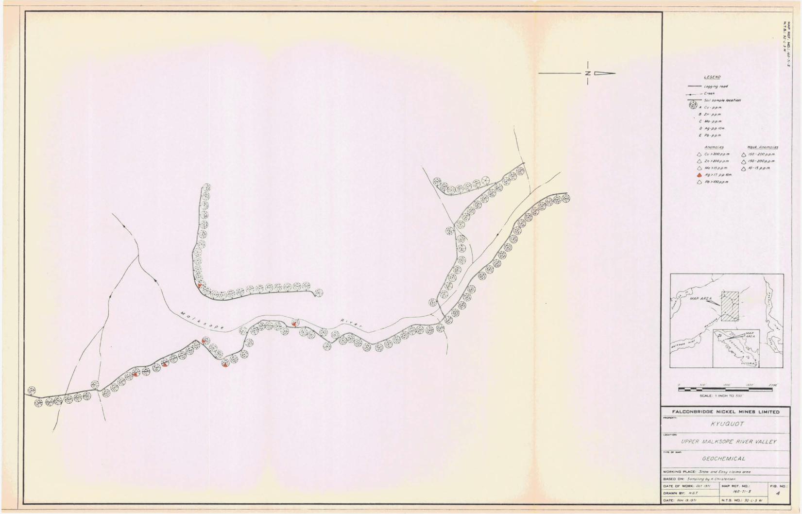
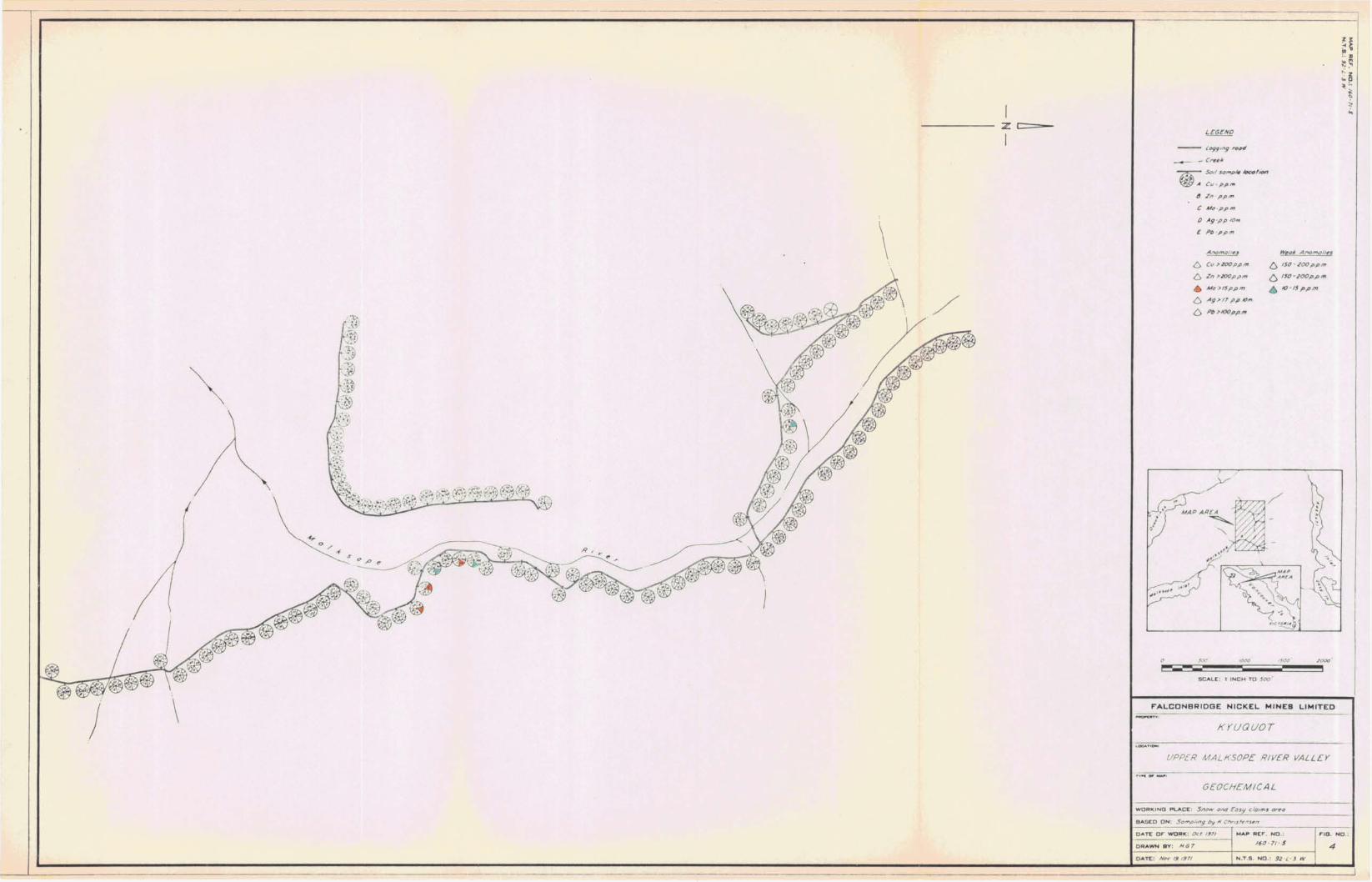
Laboratory i n Vancouver. The r e s u l t s a r e shown i n Fig. 4. The
1" - 500' sca le copy of Fig. 4 has been coloured up f o r copper, and
four 50% reductions coloured up f o r each of t h e other elements.
One-hundred-and-twenty-one samples were co l l ec ted , from which the
following information was deduced.
Weak Regional Threshold Anomalies Anomalies
Element Background (ppm) c (ppm) ( P P ~ ) ( P P ~ >
CU 74 200 . 150-200 >200
Zn 5 6 200 150-200 >200
MO 3 15 10-15 > 15
Ag 1.0 1.7 >1.7
Pb 3 0 100 >loo
Note t h a t on Fig. 4, Ag values a r e given i n t en th s of a p a r t pe r
mi l l ion.
The object of the sampling was t o determine the metal
concentrat ions i n s o i l t r averses along e i t h e r bank of the Malksope
River. These r e s u l t s would ind ica te t he exis tence o r not of
anomalous bedrock metal concentrat ions up t he h i l l s lopes of t he
Malksope River Valley. I f anomalies were not located adjacent t o
c anomalous creeks, then the s i l t anomalies were presumably derived
from subs t an t i a l l y higher up the creeks.
- - . - -- -

- 17 -
0 The copper p lo t shows two exceptionally high valued samples
(10,450 and 1,070 ppm Cu) which have no supporting, adjacent,
reasonably high values. Analytical re-runs confirmed the high
values. These two r e su l t s presumably represent f o r tu i t ous samples .
from extremely localized copper concentrations due t o s i ng l e boulders
containing copper minerals. These two values a r e the re fore d i s -
counted e f fec t ive ly . None of t he other anomalous samples group i n t o
an impressive anomaly, but r a t h e r a re a s e r i e s of randun spot highs.
These l a rge ly occur over volcanic bedrock and probably r e f l e c t
narrow "high grade" veins o r shear type sources. The only anomaly
over t h e porphyry i s a weak one near the 10,450 and 1,070 ppm Cu
samples, near the contact of t he i n t ru s ive and volcanics adjacent
t o t he north-northwesterly f a u l t . Disseminated p y r i t e and occasional
t r a c e s of disseminated chalcopyrite were noted i n t h i s a r ea of
breccia ted in t rus ive . From the absence of a s i gn i f i c an t anomaly over
t h e i n t ru s ive it i s concluded t h a t the creek anomalies a r e derived
from sources i n the Can-Fer ground. In t he case of t he northern
('. creek it flows over exposures of massive p y r i t e and chalcopyrite.
The background copper content of the s o i l s of t he whole a rea i s high.
The zinc anomalies occur almost without exception Gver
areas of limestone. This is t o be expected i n view of t h e a f f i n i t y
of limestone f o r zinc. Although minor occurrences of spha l e r i t e i n
t he limestone are p r o l i f i c (see Dodsonfs prospecting r e s u l t s from
1970), no major concentrations have been found. The s ing le point
na ture of the s o i l anomalies r e f l e c t s t h i s sporadic occurrence of
minor showings.
The only molybdenum anomalies occur i n the southwest of
t h e i n t ru s ive i n i t s contact zone with the volcanics, adjacent t o
t h e north-northwesterly f a u l t . These anomalies coincide with copper
anomalies. Outcrops i n t he v i c in i t y . contain only t r ace s of chalco-
p y r i t e while molybdenum minerals were not observed. Therefore,
e i t h e r these r a the r weak anomalies were caused by minute quan t i t i es
O of molybdenum in the con tac t / fau l t zone, o r have been transported
down the e a s t h i l l slope from unexposed mineralized bedrock.
. -- - - - - - - - -----

- 18 -
Si lver anomalies are a l l of the s i ng l e sample type with
no bu i ld up e i t he r s i de and a re sporadical ly d i s t r i bu t ed . None of
t he anomalies is considered s i gn i f i c an t .
The lead anomalies, l i k e the zinc, occur over o r near
areas of limestone. The anomalies on the southeast road occur i n a
zone of interbedded limey shales and volcanics. S ign i f ican t concen-
t r a t i o n s of galena were not noted by prospectors i n the v i c i n i t y of
any of these anomalies. In a l l probabi l i ty , therefore , the i so la ted
s i ng l e point anomalies r e f l e c t ins ign i f ican t galena concentrations.
Only those values down the southeast road could r e f l e c t more
important lead mineralization upslope t o t h e e a s t .
The s o i l sampling has therefore shown t h a t -
i ) t he silt anomalies i n t he northern t r i b u t a r y creek draining
the porphyry are not derived from the porphyry generally,
but from spec i f i c showings on Bralorne Can-Fer ground;
s i I / - _
i i ) the only anomaly of any poss ible s ignif icance is a
molybdenum with coincident copper a t the south end of the
in t rus ive which could poss ibly r e f l e c t mineralized
bedrock upslope t o the e a s t , r a the r than loca l , sporadic,
weak, mineralization;
i i i ) a lead anomaly i n t h e southeast with minor coincident
zinc anomalies could a l so possibly ind ica te mineralization
upslope t o the ea s t .
9. CONCLUSIONS
The r e s u l t s of the geological and geochemical surveys
undertaken by Harper and Christensen a r e unfortunately disappointing.
The area i s favourable geologically. The porphyry has widely
developed abundant disseminated p y r i t e and a l so f a u l t controlled
CB small lenses of chalcopyrite as on the Bralorne claims. However,
the re are no indications of porphyry copper mineral izat ion. The
- - ppppp pppp ppp-


Recommended