Know the Earth…Show the Way
NATIONAL GEOSPATIAL-INTELLIGENCE AGENCYApproved for Public Release 06-128
Geolocation Accuracy Evaluations of OrbView-3, EROS-A, and SPOT-5 ImageryGeolocation Accuracy Evaluations of OrbView-3, EROS-A, and SPOT-5 Imagery
Civil and Commercial Applications Project (CCAP)Civil and Commercial Applications Project (CCAP)
Paul Bresnahan15 March 2006Civil Commercial Imagery Evaluation Workshop(703) 735-3565, [email protected]
Paul Bresnahan15 March 2006Civil Commercial Imagery Evaluation Workshop(703) 735-3565, [email protected]
2
NATIONAL GEOSPATIAL-INTELLIGENCE AGENCY
Know the Earth…Show the WayApproved for Public Release 06-128
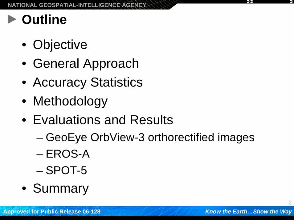
Outline
• Objective• General Approach• Accuracy Statistics• Methodology• Evaluations and Results
– GeoEye OrbView-3 orthorectified images– EROS-A– SPOT-5
• Summary
3
NATIONAL GEOSPATIAL-INTELLIGENCE AGENCY
Know the Earth…Show the WayApproved for Public Release 06-128
Objective
For each imagery type…To determine whether a sample of
panchromatic commercial imagery products meet the vendor-stated absolute geolocation
accuracy specifications
4
NATIONAL GEOSPATIAL-INTELLIGENCE AGENCY
Know the Earth…Show the WayApproved for Public Release 06-128
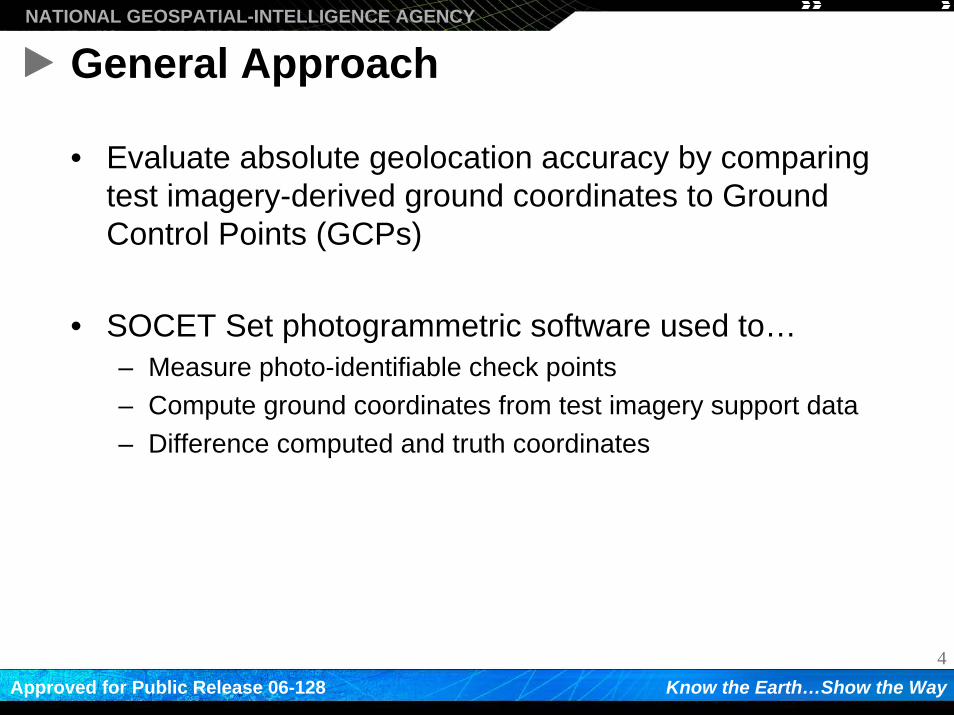
General Approach
• Evaluate absolute geolocation accuracy by comparing test imagery-derived ground coordinates to Ground Control Points (GCPs)
• SOCET Set photogrammetric software used to…– Measure photo-identifiable check points– Compute ground coordinates from test imagery support data– Difference computed and truth coordinates
5
NATIONAL GEOSPATIAL-INTELLIGENCE AGENCY
Know the Earth…Show the WayApproved for Public Release 06-128
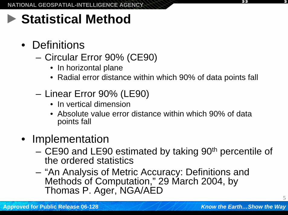
Statistical Method
• Definitions– Circular Error 90% (CE90)
• In horizontal plane• Radial error distance within which 90% of data points fall
– Linear Error 90% (LE90)• In vertical dimension• Absolute value error distance within which 90% of data
points fall
• Implementation– CE90 and LE90 estimated by taking 90th percentile of
the ordered statistics– “An Analysis of Metric Accuracy: Definitions and
Methods of Computation,” 29 March 2004, by Thomas P. Ager, NGA/AED
6
NATIONAL GEOSPATIAL-INTELLIGENCE AGENCY
Know the Earth…Show the WayApproved for Public Release 06-128
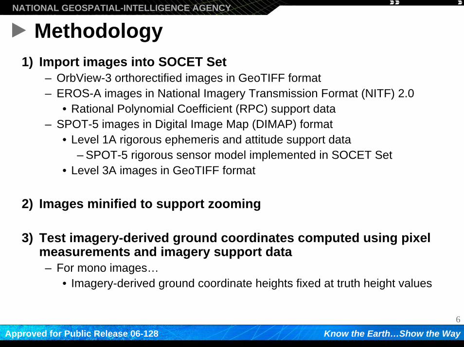
Methodology1) Import images into SOCET Set
– OrbView-3 orthorectified images in GeoTIFF format– EROS-A images in National Imagery Transmission Format (NITF) 2.0
• Rational Polynomial Coefficient (RPC) support data– SPOT-5 images in Digital Image Map (DIMAP) format
• Level 1A rigorous ephemeris and attitude support data– SPOT-5 rigorous sensor model implemented in SOCET Set
• Level 3A images in GeoTIFF format
2) Images minified to support zooming
3) Test imagery-derived ground coordinates computed using pixel measurements and imagery support data– For mono images…
• Imagery-derived ground coordinate heights fixed at truth height values
7
NATIONAL GEOSPATIAL-INTELLIGENCE AGENCY
Know the Earth…Show the WayApproved for Public Release 06-128
Methodology (cont.)
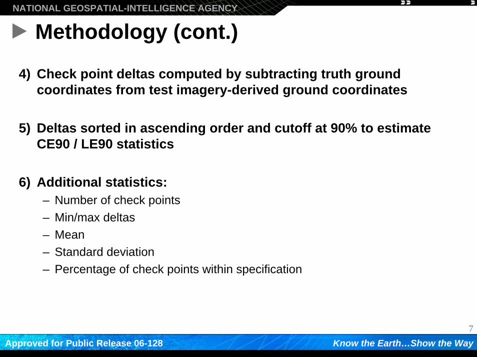
4) Check point deltas computed by subtracting truth ground coordinates from test imagery-derived ground coordinates
5) Deltas sorted in ascending order and cutoff at 90% to estimate CE90 / LE90 statistics
6) Additional statistics:– Number of check points– Min/max deltas– Mean– Standard deviation– Percentage of check points within specification
8
NATIONAL GEOSPATIAL-INTELLIGENCE AGENCY
Know the Earth…Show the WayApproved for Public Release 06-128
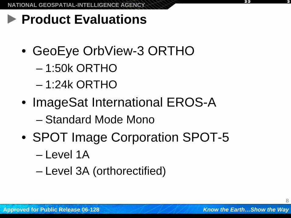
Product Evaluations
• GeoEye OrbView-3 ORTHO– 1:50k ORTHO– 1:24k ORTHO
• ImageSat International EROS-A– Standard Mode Mono
• SPOT Image Corporation SPOT-5– Level 1A– Level 3A (orthorectified)
9
NATIONAL GEOSPATIAL-INTELLIGENCE AGENCY
Know the Earth…Show the WayApproved for Public Release 06-128
GeoEye OrbView-3 ORTHO Results
10
NATIONAL GEOSPATIAL-INTELLIGENCE AGENCY
Know the Earth…Show the WayApproved for Public Release 06-128
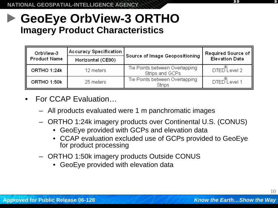
GeoEye OrbView-3 ORTHOImagery Product Characteristics
• For CCAP Evaluation…– All products evaluated were 1 m panchromatic images– ORTHO 1:24k imagery products over Continental U.S. (CONUS)
• GeoEye provided with GCPs and elevation data• CCAP evaluation excluded use of GCPs provided to GeoEye
for product processing– ORTHO 1:50k imagery products Outside CONUS
• GeoEye provided with elevation data
®
®
11
NATIONAL GEOSPATIAL-INTELLIGENCE AGENCY
Know the Earth…Show the WayApproved for Public Release 06-128
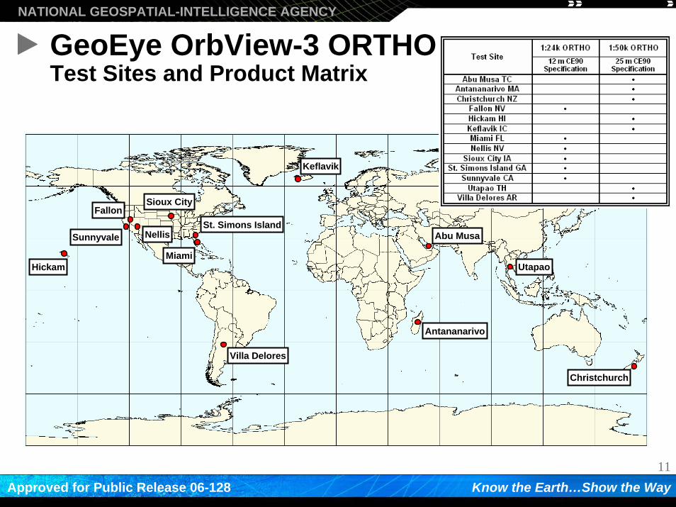
GeoEye OrbView-3 ORTHOTest Sites and Product Matrix
Villa Delores
Hickam
Antananarivo
Abu Musa
Utapao
Christchurch
Miami
St. Simons Island
Sioux CityFallon
Keflavik
NellisSunnyvale
12
NATIONAL GEOSPATIAL-INTELLIGENCE AGENCY
Know the Earth…Show the WayApproved for Public Release 06-128
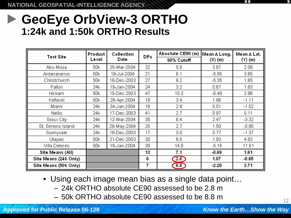
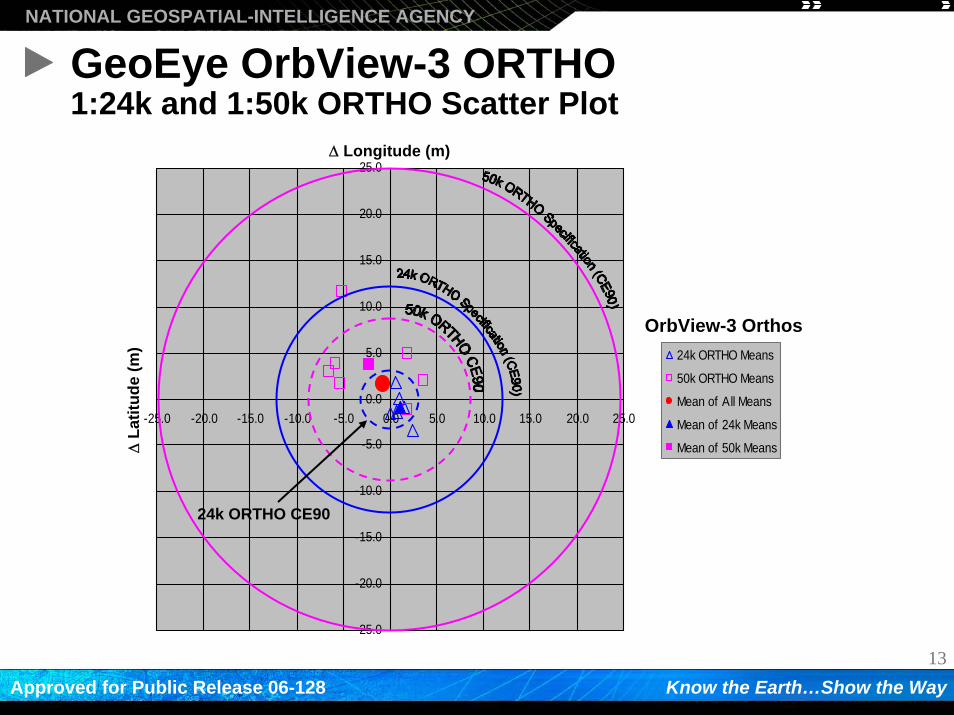
GeoEye OrbView-3 ORTHO1:24k and 1:50k ORTHO Results
• Using each image mean bias as a single data point…– 24k ORTHO absolute CE90 assessed to be 2.8 m– 50k ORTHO absolute CE90 assessed to be 8.8 m
13
NATIONAL GEOSPATIAL-INTELLIGENCE AGENCY
Know the Earth…Show the WayApproved for Public Release 06-128
GeoEye OrbView-3 ORTHO1:24k and 1:50k ORTHO Scatter Plot
-25.0
-20.0
-15.0
-10.0
-5.0
0.0
5.0
10.0
15.0
20.0
25.0
-25.0 -20.0 -15.0 -10.0 -5.0 0.0 5.0 10.0 15.0 20.0 25.0
24k ORTHO Means
50k ORTHO Means
Mean of All Means
Mean of 24k Means
Mean of 50k Means
Δ Longitude (m)Δ
Latit
ude
(m)
OrbView-3 Orthos
24k ORTHO CE90
14
NATIONAL GEOSPATIAL-INTELLIGENCE AGENCY
Know the Earth…Show the WayApproved for Public Release 06-128
ImageSat International EROS-A
15
NATIONAL GEOSPATIAL-INTELLIGENCE AGENCY
Know the Earth…Show the WayApproved for Public Release 06-128
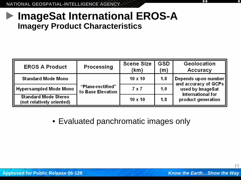
ImageSat International EROS-AImagery Product Characteristics
• Evaluated panchromatic images only
16
NATIONAL GEOSPATIAL-INTELLIGENCE AGENCY
Know the Earth…Show the WayApproved for Public Release 06-128
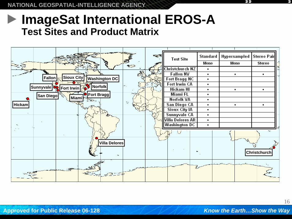
ImageSat International EROS-ATest Sites and Product Matrix
Villa Delores
Hickam
Norfolk
Fallon
Christchurch
MiamiFort Bragg
Sioux City
San Diego
Washington DC
Fort IrwinSunnyvale
17
NATIONAL GEOSPATIAL-INTELLIGENCE AGENCY
Know the Earth…Show the WayApproved for Public Release 06-128
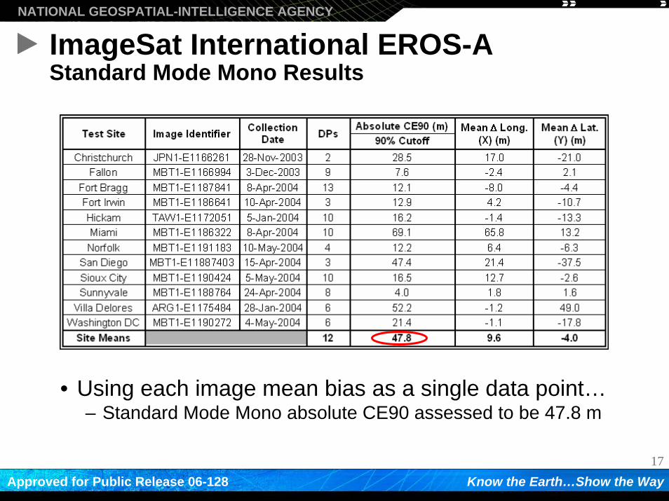
ImageSat International EROS-AStandard Mode Mono Results
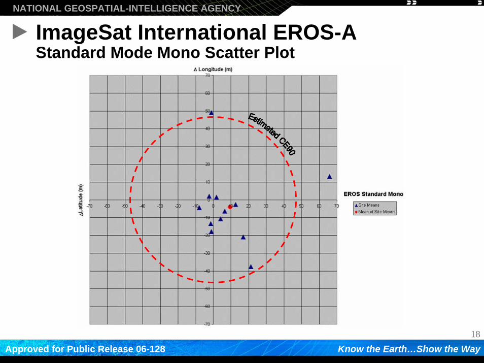
• Using each image mean bias as a single data point…– Standard Mode Mono absolute CE90 assessed to be 47.8 m
18
NATIONAL GEOSPATIAL-INTELLIGENCE AGENCY
Know the Earth…Show the WayApproved for Public Release 06-128
ImageSat International EROS-AStandard Mode Mono Scatter Plot
19
NATIONAL GEOSPATIAL-INTELLIGENCE AGENCY
Know the Earth…Show the WayApproved for Public Release 06-128
SPOT Image Corporation SPOT-5 Results
20
NATIONAL GEOSPATIAL-INTELLIGENCE AGENCY
Know the Earth…Show the WayApproved for Public Release 06-128
SPOT Image Corporation SPOT-5Imagery Product Characteristics
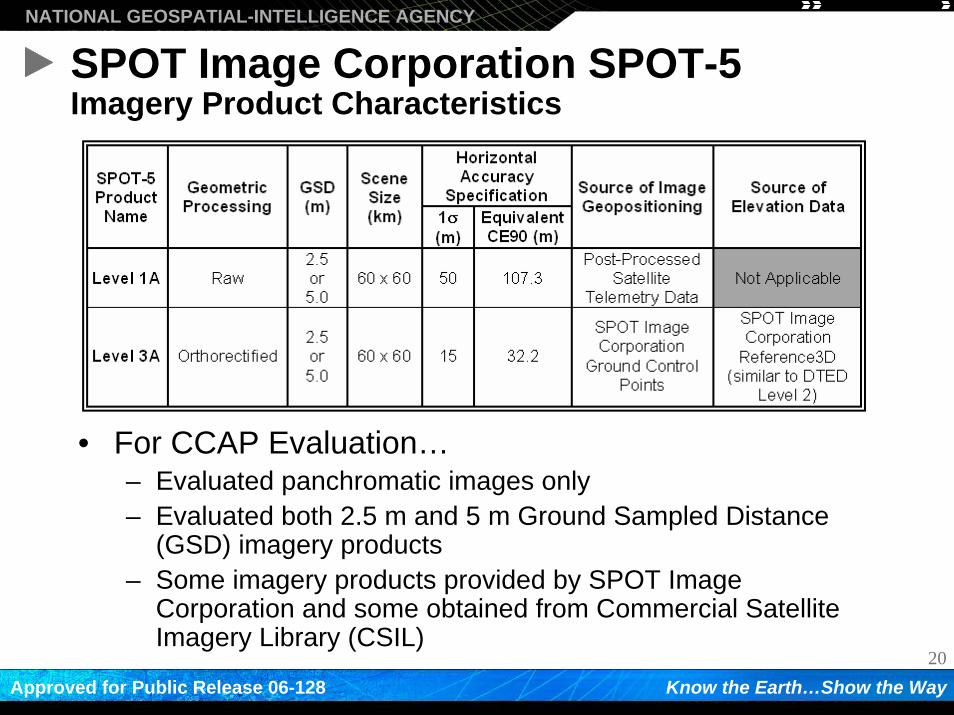
• For CCAP Evaluation…– Evaluated panchromatic images only– Evaluated both 2.5 m and 5 m Ground Sampled Distance
(GSD) imagery products– Some imagery products provided by SPOT Image
Corporation and some obtained from Commercial Satellite Imagery Library (CSIL)
21
NATIONAL GEOSPATIAL-INTELLIGENCE AGENCY
Know the Earth…Show the WayApproved for Public Release 06-128
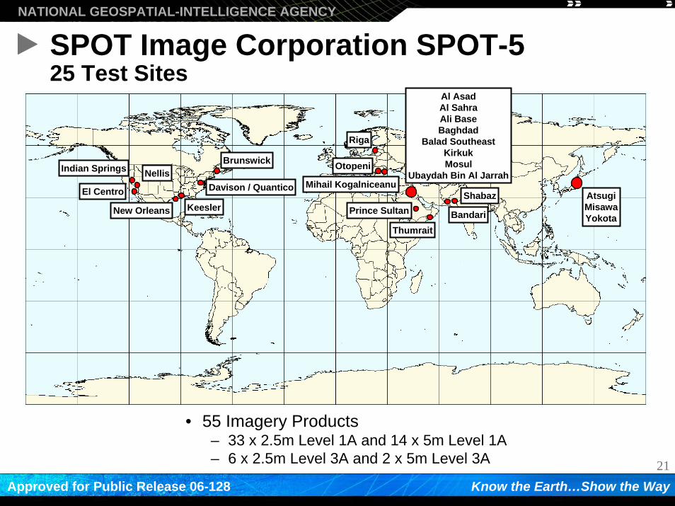
SPOT Image Corporation SPOT-525 Test Sites
• 55 Imagery Products– 33 x 2.5m Level 1A and 14 x 5m Level 1A– 6 x 2.5m Level 3A and 2 x 5m Level 3A
New Orleans KeeslerBandari
Al AsadAl SahraAli BaseBaghdad
Balad SoutheastKirkukMosul
Ubaydah Bin Al Jarrah
AtsugiMisawaYokota
Davison / Quantico
Brunswick
Mihail KogalniceanuIndian Springs
Riga
Nellis
El Centro Shabaz
Otopeni
Prince Sultan
Thumrait
22
NATIONAL GEOSPATIAL-INTELLIGENCE AGENCY
Know the Earth…Show the WayApproved for Public Release 06-128
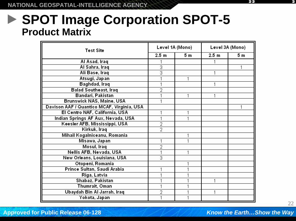
SPOT Image Corporation SPOT-5Product Matrix
23
NATIONAL GEOSPATIAL-INTELLIGENCE AGENCY
Know the Earth…Show the WayApproved for Public Release 06-128
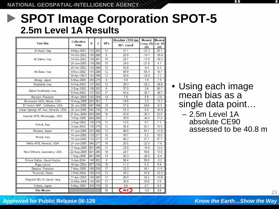
SPOT Image Corporation SPOT-52.5m Level 1A Results
• Using each image mean bias as a single data point…– 2.5m Level 1A
absolute CE90 assessed to be 40.8 m
24
NATIONAL GEOSPATIAL-INTELLIGENCE AGENCY
Know the Earth…Show the WayApproved for Public Release 06-128
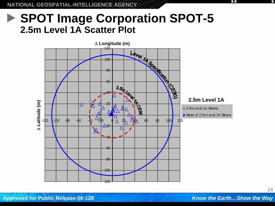
SPOT Image Corporation SPOT-52.5m Level 1A Scatter Plot
-120
-100
-80
-60
-40
-20
0
20
40
60
80
100
120
-120 -100 -80 -60 -40 -20 0 20 40 60 80 100 120
2.5m Level 1A Means
Mean of 2.5m Level 1A Means
Δ Longitude (m)Δ
Latit
ude
(m) 2.5m Level 1A
25
NATIONAL GEOSPATIAL-INTELLIGENCE AGENCY
Know the Earth…Show the WayApproved for Public Release 06-128
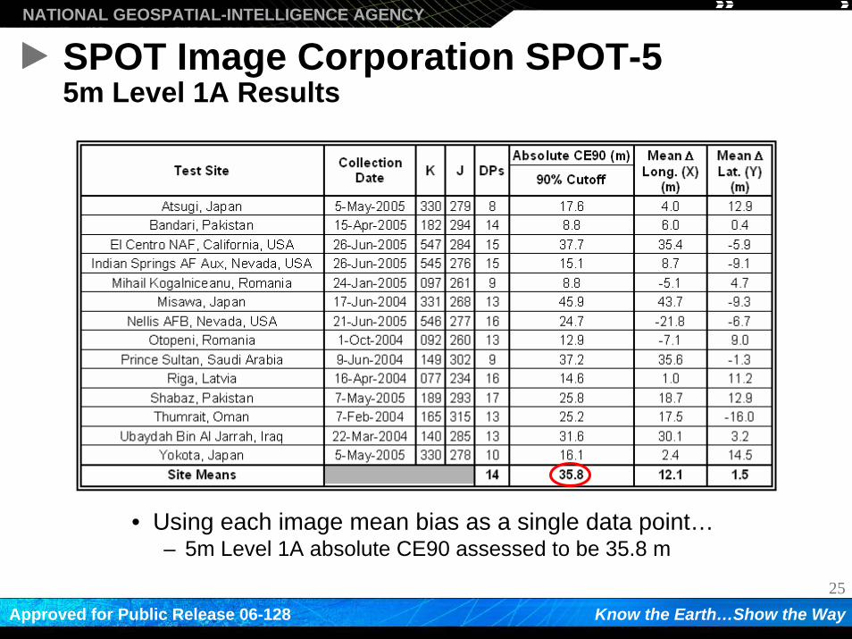
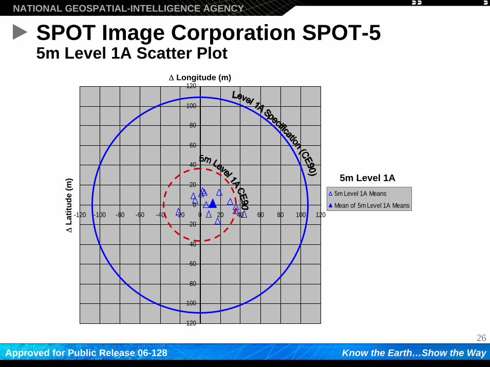
SPOT Image Corporation SPOT-55m Level 1A Results
• Using each image mean bias as a single data point…– 5m Level 1A absolute CE90 assessed to be 35.8 m
26
NATIONAL GEOSPATIAL-INTELLIGENCE AGENCY
Know the Earth…Show the WayApproved for Public Release 06-128
SPOT Image Corporation SPOT-55m Level 1A Scatter Plot
-120
-100
-80
-60
-40
-20
0
20
40
60
80
100
120
-120 -100 -80 -60 -40 -20 0 20 40 60 80 100 120
5m Level 1A Means
Mean of 5m Level 1A Means
Δ Longitude (m)Δ
Latit
ude
(m) 5m Level 1A
27
NATIONAL GEOSPATIAL-INTELLIGENCE AGENCY
Know the Earth…Show the WayApproved for Public Release 06-128
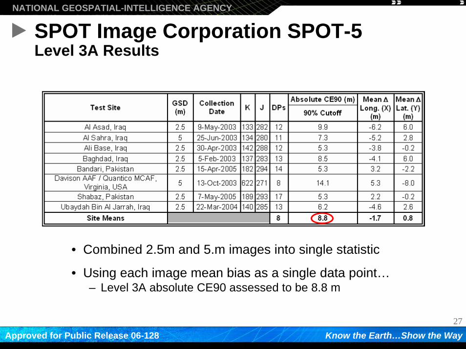
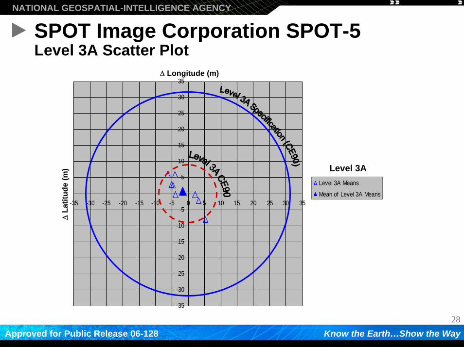
SPOT Image Corporation SPOT-5Level 3A Results
• Combined 2.5m and 5.m images into single statistic
• Using each image mean bias as a single data point…– Level 3A absolute CE90 assessed to be 8.8 m
28
NATIONAL GEOSPATIAL-INTELLIGENCE AGENCY
Know the Earth…Show the WayApproved for Public Release 06-128
SPOT Image Corporation SPOT-5Level 3A Scatter Plot
-35
-30
-25
-20
-15
-10
-5
0
5
10
15
20
25
30
35
-35 -30 -25 -20 -15 -10 -5 0 5 10 15 20 25 30 35
Level 3A Means
Mean of Level 3A Means
Δ Longitude (m)Δ
Latit
ude
(m) Level 3A
29
NATIONAL GEOSPATIAL-INTELLIGENCE AGENCY
Know the Earth…Show the WayApproved for Public Release 06-128
Summary
• GeoEye OrbView-3 ORTHO– ORTHO 24k and ORTHO 50k panchromatic
products met vendor-stated absolute accuracy specifications
• ImageSat International EROS-A– Absolute CE90 assessed for Standard Mode Mono
panchromatic products
• SPOT Image Corporation SPOT-5– Level 1A and Level 3A panchromatic products met
vendor-stated absolute accuracy specifications

30
NATIONAL GEOSPATIAL-INTELLIGENCE AGENCY
Know the Earth…Show the WayApproved for Public Release 06-128
NATIONAL GEOSPATIAL-INTELLIGENCE AGENCY
Know the Earth…Show the Way
Recommended