Signalized Intersection Inventory Application
Functional Requirements, Preliminary Software Design, and System Architecture
Prepared for FDOT District 5 by IBI Group (Florida) Inc. July 2019

IBI GROUP
INTERSECTION INVENTORY APPLICATION
FUNCTIONAL REQUIREMENTS, PRELIMINARY SOFTWARE DESIGN, AND SYSTEM ARCHITECTURE
PREPARED FOR FDOT DISTRICT 5
Document Control Page
CLIENT: FDOT
REPORT TITLE:
Signalized Intersection Inventory Application Functional Requirements, Preliminary Software Design, and System Architecture
VERSION: 4.0 ORIGINATOR: Kriss Whittaker‐Lee, Neena Soans REVIEWER: Neena Soans, Liviu Birjega AUTHORIZATION: Neena Soans HISTORY:
VERSION DATE AUTHORS / REVIEWERS CHANGE DESCRIPTION
0.1 November 05, 2018 Kriss Whittaker‐Lee, Neena Soans, Liviu Birjega
Internal Draft
1.0 December 06, 2018 Kriss Whittaker‐Lee, Neena Soans, Liviu Birjega
Submitted Draft
2.0 February 20, 2019 Kriss Whittaker‐Lee
Neena Soans,
Liviu Birjega
Revised Draft
3.0 May 17, 2019 Kriss Whittaker‐Lee
Neena Soans,
Liviu Birjega
Revised Draft
3.0 July 16, 2019 Kriss Whittaker‐Lee
Neena Soans,
Liviu Birjega
Revised Draft
July 2019

IBI GROUP SIGNALIZED INTERSECTION INVENTORY APPLICATION FUNCTIONAL REQUIREMENTS,
PRELIMINARY SOFTWARE DESIGN, AND SYSTEM ARCHITECTURE PREPARED FOR FDOT DISTRICT 5
Table of Contents
Table of Contents
1 Document Identification ........................................................................................................................... 4 1.1 Purpose ................................................................................................................................................. 4 1.2 Overview ............................................................................................................................................... 4
2 System Architecture ................................................................................................................................. 5 2.1 System Overview .................................................................................................................................. 5 2.2 Technology ........................................................................................................................................... 5 2.3 System Architecture ............................................................................................................................. 5
3 Functional Requirements .......................................................................................................................... 7 3.1 Interim Intersection Inventory Application Data ................................................................................. 7 3.2 Signalized Intersection Unlocked Summary Spreadsheet Data ........................................................... 7 3.3 Intersection Inventory Application ....................................................................................................... 7 3.4 MIMS Enhancements ........................................................................................................................... 8
Appendix A – Operational Workflows and Screenshots .................................................................................... 9
Appendix B – Data Definition ......................................................................................................................... 27
Appendix C – Intersection Inventory API ........................................................................................................ 33

IBI GROUP SIGNALIZED INTERSECTION INVENTORY APPLICATION FUNCTIONAL REQUIREMENTS,
PRELIMINARY SOFTWARE DESIGN, AND SYSTEM ARCHITECTURE PREPARED FOR FDOT DISTRICT 5
1 Document Identification
1.1 Purpose The purpose of this Intersection Inventory Application Functional Requirements, Preliminary Software Design and System Architecture document is to clearly and concisely describe the functionality that the Intersection Inventory Application shall possess, and the operations it shall perform, to meet FDOT District 5’s operational needs and objectives.
1.2 Overview The primary purpose of the Intersection Inventory Application is to facilitate and streamline the inventorying and auditing of signalized intersections, associated attributes and devices, and to subsequently import them into MIMS for maintenance and inventory tracking purposes. The Intersection Inventory Application shall provide maintenance staff with a mechanism to create and update signalized intersections, identify intersection‐specific details, and create and update associated approaches and devices. The Application will be a Single‐Page Application website and will be visually optimized to run on a large tablet or laptop. The data from the Application will be sent to the MIMS central system, the data will be stored in the MIMS database, and related details will be tracked and managed via the MIMS user interface. New pages and functionality will be created in MIMS to display, track and manage signalized intersection‐related data. The existing functionality and architecture of MIMS is not covered in this document, and Intersection related Assets will be treated like all other Assets in MIMS and will follow existing business rules and system workflows. The main design goals include:
Develop a utility to validate and import data from the interim Intersection Inventory Application.
Develop a utility to validate and import data from the SignalizedIntersectionUnlockedSummary spreadsheet.
Develop and expose an API to provide Intersection data to third parties.
Develop an Intersection Inventory Application for use on laptops and tablets in the field with a valid internet connection.
Allow a user to view the relative geometric design of the intersection, within predefined intersection geometries.
Have a streamlined process for creating and modifying an Intersection Controller, connected Intersections and their associated Devices, and Approaches.
Allow a user to view the relative positions of detectors within an Approach.
Update MIMS to display and manage Intersection and Approach‐related data.

IBI GROUP SIGNALIZED INTERSECTION INVENTORY APPLICATION FUNCTIONAL REQUIREMENTS,
PRELIMINARY SOFTWARE DESIGN, AND SYSTEM ARCHITECTURE PREPARED FOR FDOT DISTRICT 5
2 System Architecture
2.1 System Overview The Intersection Inventory Application will be a web application hosted on Microsoft IIS. The application will connect to the system’s data access and storage layer through dedicated RESTful APIs using TLS (HTTPS). For security reasons, there will be two API types: Authentication APIs and Data APIs; which will have distinct external (Internet) URLs. Data APIs will not be accessible unless the user is authenticated with the system.
2.2 Technology The following technologies shall be utilized in implementing the system:
The Intersection Inventory Application will be a SPA (Single‐Page Application) web application designed and developed using Angular v.7 (TypeScript, HTML and CSS).
The RESTful APIs will be designed and developed using ASP.NET WebAPI / C#
The Data Access service(s) will be designed and developed using .NET / C#
The Database will be hosted on Microsoft SQL Server
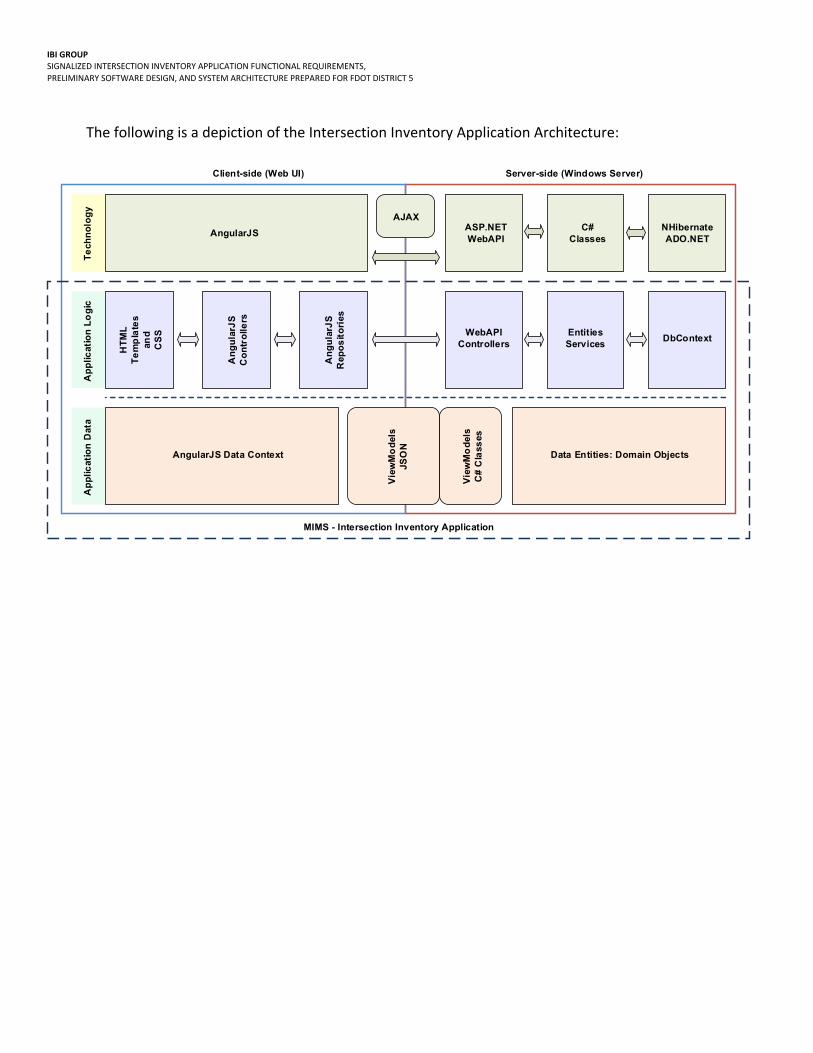
2.3 System Architecture The following is a depiction of the overall System Architecture:
IBI GROUP SIGNALIZED INTERSECTION INVENTORY APPLICATION FUNCTIONAL REQUIREMENTS,
PRELIMINARY SOFTWARE DESIGN, AND SYSTEM ARCHITECTURE PREPARED FOR FDOT DISTRICT 5
The following is a depiction of the Intersection Inventory Application Architecture:
AngularJSA
ng
ula
rJS
Co
ntr
olle
rs
An
gu
larJ
SR
epo
sit
ori
es
HT
ML
Te
mp
late
san
dC
SS
AJAXASP.NETWebAPI
AngularJS Data Context
Vie
wM
od
els
JSO
N
Vie
wM
od
els
C#
Cla
sses
Data Entities: Domain Objects
WebAPIControllers
EntitiesServices
DbContext
C#Classes
NHibernateADO.NET
Te
chn
olo
gy
Ap
plic
atio
n L
og
icA
pp
licat
ion
Dat
a
Client-side (Web UI) Server-side (Windows Server)
MIMS - Intersection Inventory Application

IBI GROUP SIGNALIZED INTERSECTION INVENTORY APPLICATION FUNCTIONAL REQUIREMENTS,
PRELIMINARY SOFTWARE DESIGN, AND SYSTEM ARCHITECTURE PREPARED FOR FDOT DISTRICT 5
3 Functional Requirements Appendix A includes Operational Workflows and Proposed Screenshots and should be referenced as part of overall Software Functional Requirements, and Preliminary Software Design.
3.1 Interim Intersection Inventory Application Data
Req. ID Requirement Text
FN‐1.01 Data from the Interim Intersection Inventory application shall be exported into an excel spreadsheet for review and revision, and where relevant data from the SignalizedIntersectionUnlockedSummary spreadsheet shall be included.
FN‐1.02 The Interim Intersection Inventory data utility shall manage the export, normalization, and validation of data, for import into new Intersection Inventory Application data schema.
FN‐1.03 A validation report shall be generated to identify errors and missing data based on the new Intersection Inventory Application data schema.
FN‐1.04 The data shall be formatted to match existing MIMS data formats, where applicable.
3.2 Signalized Intersection Unlocked Summary Spreadsheet Data
Req. ID Requirement Text
FN‐2.01 The Signalized Intersection Unlocked Summary data utility shall manage the export, normalization, and validation of data, for import into new Intersection Inventory Application data schema.
FN‐2.02 A validation report shall be generated to identify errors and missing data based on the new Intersection Inventory Application data schema.
FN‐2.03 The data shall be formatted to match existing MIMS data formats, where applicable.
3.3 Intersection Inventory Application
Req. ID Requirement Text
FN‐3.01 The Application shall display appropriately on a large tablet or laptop, which shall have access to a cellular data network and may or may not have access to accurate GPS coordinates.
FN‐3.02 The System shall support an external API for the purpose of making Intersection data available to authorized third parties. The external API is defined and included in Appendix B.
FN‐3.03 The System shall import data from an FDOT provided spreadsheet, which includes Roadway IDs, Roadway Names, milepost (at every tenth of a mile) and associated latitude and longitude. The System shall use the saved or user provided coordinates to look‐up and display the closest list of roadways (based on a preconfigured radius) and allow a User to select one or many Roadways where relevant (e.g. to associate one or more returned roadways with an intersection).
FN‐3.04 The Application shall require User Authentication, i.e. username and password.

IBI GROUP SIGNALIZED INTERSECTION INVENTORY APPLICATION FUNCTIONAL REQUIREMENTS,
PRELIMINARY SOFTWARE DESIGN, AND SYSTEM ARCHITECTURE PREPARED FOR FDOT DISTRICT 5
FN‐3.12 The Application shall allow a user to select a preconfigured Geometric Intersection Type, assign a description and enter information for the Intersection(s) associated with the selected geometry.
FN‐3.13 The Application shall allow a user to create an Intersection Controller and associate one or many intersections with a single Controller. The Controller’s data attributes are defined in Appendix C.
FN‐3.14 The Application shall allow a user to select and update an Intersection and associate Cabinets, Devices and Approaches (the number of approaches will be predefined based on the selected Intersection Type). The Intersection’s data attributes are defined in Appendix C.
FN‐3.15 The Application shall allow a user to select the relevant Intersection Approach, the compass orientation of each Approach, and associated Zone/Loops, Lanes, Signal Heads and Devices. An Approach’s data attributes are defined in Appendix C.
FN‐3.16 The Application shall allow a user to create and update a Lane and define associated movement restrictions. A Lane ’s data attributes are defined in Appendix C.
FN‐3.17 The Application shall at a minimum display a geometric representation of the Intersection and Approach orientation, a list of associated Devices, and a single Approach with up to 10 Lanes. Each Lane shall include at a minimum the display of lane level detectors and lane restrictions.
FN‐3.18 The Application User Interface where relevant shall include tooltips and / or the means to access and download a PDF where addition user information and guidelines shall be described.
FN‐3.20 The Application User Interface where relevant shall identify required fields and fields that can be populated in the office.
3.4 MIMS Enhancements
FN‐4.01 MIMS shall be updated to include data objects for Intersections, Approaches and Lanes.
FN‐4.02 MIMS shall be updated to include a visual representation of Intersections, Approaches, and Lanes –
similar to the Intersection Inventory Application user interface, view and edit only.
FN‐4.02 MIMS shall be updated to allow a user to track and manage Intersections and associated
Approaches, Lanes and Devices ‐ – similar to the Intersection Inventory Application user interface,
view and edit only.
FN‐4.03 MIMS shall be updated to pre‐filter the Assets and Devices grids (to be able to
accommodate the significant number of Assets we anticipate from the Intersection
Inventory Application).
IBI GROUP SIGNALIZED INTERSECTION INVENTORY APPLICATION FUNCTIONAL REQUIREMENTS,
PRELIMINARY SOFTWARE DESIGN, AND SYSTEM ARCHITECTURE PREPARED FOR FDOT DISTRICT 5
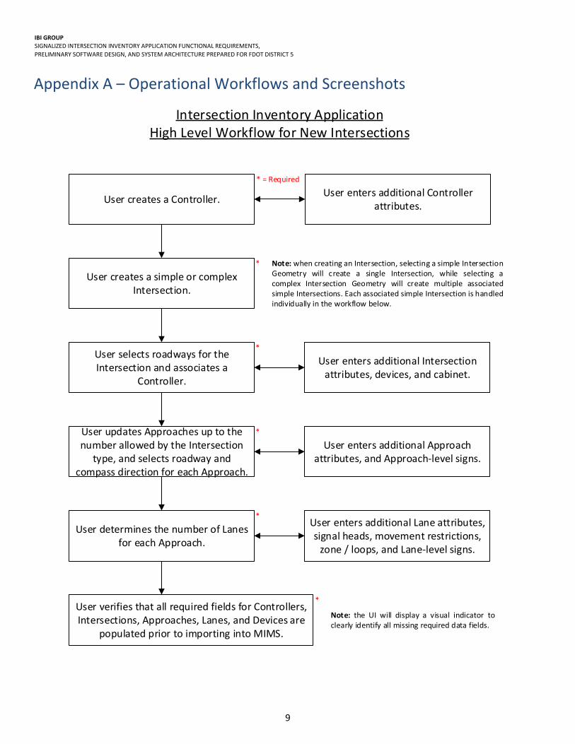
9
Appendix A – Operational Workflows and Screenshots
User creates a Controller.
User creates a simple or complex Intersection.
Note: when creating an Intersection, selecting a simple Intersection Geometry will create a single Intersection, while selecting a complex Intersection Geometry will create multiple associated simple Intersections. Each associated simple Intersection is handled individually in the workflow below.
User selects roadways for the Intersection and associates a
Controller.
User enters additional Intersection attributes, devices, and cabinet.
* = Required
*
*
User updates Approaches up to the number allowed by the Intersection
type, and selects roadway and compass direction for each Approach.
User enters additional Approach attributes, and Approach‐level signs.
*
User determines the number of Lanes for each Approach.
User enters additional Lane attributes, signal heads, movement restrictions, zone / loops, and Lane‐level signs.
*
User verifies that all required fields for Controllers, Intersections, Approaches, Lanes, and Devices are
populated prior to importing into MIMS.
*
Intersection Inventory ApplicationHigh Level Workflow for New Intersections
User enters additional Controller attributes.
Note: the UI will display a visual indicator to clearly identify all missing required data fields.

IBI GROUP SIGNALIZED INTERSECTION INVENTORY APPLICATION FUNCTIONAL REQUIREMENTS,
PRELIMINARY SOFTWARE DESIGN, AND SYSTEM ARCHITECTURE PREPARED FOR FDOT DISTRICT 5
10
User selects an existing Controller and enters missing attributes.
User selects an Intersection type and roadways for an existing Intersection and associates a Controller, as needed.
User enters missing Intersection attributes, devices, and cabinet.
User updates Approaches up to the number allowed by the Intersection
type, and selects roadway and compass direction for each Approach.
User enters additional Approach attributes, and Approach‐level signs.
*
User determines the number of Lanes for each Approach.
User enters additional Lane attributes, signal heads, movement restrictions, zone / loops, and Lane‐level signs.
*
User verifies that all required fields for Controllers, Intersections, Approaches, Lanes, and Devices are
populated prior to importing into MIMS.
*
Intersection Inventory ApplicationHigh Level Workflow for Imported Intersections
Note: the UI will display a visual indicator to clearly identify all missing required data fields.
* = Required

IBI GROUP SIGNALIZED INTERSECTION INVENTORY APPLICATION FUNCTIONAL REQUIREMENTS,
PRELIMINARY SOFTWARE DESIGN, AND SYSTEM ARCHITECTURE PREPARED FOR FDOT DISTRICT 5
11
The Intersection(s) are created by the system with the Intersection type,
description and system ID.
Intersection Inventory ApplicationWorkflow for Intersection Creation
User clicks on the “Add New” button in the Intersection grid.
User selects an Intersection Geometry from the presented thumbnails or a
dropdown list.
Simple or ComplexIntersection Geometry?
User selects which of the associated simple Intersections to include for the
complex geometry. (Default all)
User enters an informative description for the Intersection(s).
Simple Complex
User clicks on the “Save” button.

IBI GROUP SIGNALIZED INTERSECTION INVENTORY APPLICATION FUNCTIONAL REQUIREMENTS,
PRELIMINARY SOFTWARE DESIGN, AND SYSTEM ARCHITECTURE PREPARED FOR FDOT DISTRICT 5
12
Intersection Inventory ApplicationWorkflow for Updating Imported Intersections
User clicks on the “Edit” button in the Intersection grid.
User selects a simple Intersection Geometry from a dropdown list.
Is there an associated Controller?
User clicks on the “Controllers” button and selects an existing Controller.
Yes No
Are there associated roadways?
User clicks the “Get Location” button.
NoYes
Are roadways returned?
User selects the roadways from a list using type ahead filtering.
Yes No
User selects which of the returned roadways to associate with the
Intersection.
User clicks the “Save” button.
User clicks the “Save” button.

IBI GROUP SIGNALIZED INTERSECTION INVENTORY APPLICATION FUNCTIONAL REQUIREMENTS,
PRELIMINARY SOFTWARE DESIGN, AND SYSTEM ARCHITECTURE PREPARED FOR FDOT DISTRICT 5
13
Intersection Inventory ApplicationWorkflow for Updating Created Intersections
User clicks on the “Edit” button in the Intersection grid.
User clicks on the “Controllers” button and selects an existing Controller.
User enters latitude and longitude for the Intersection and clicks the “Get
Location” button.
Are roadways returned?
User selects the roadways from a list using type ahead filtering.
Yes No
User selects which of the returned roadways to associate with the
Intersection.
User clicks the “Save” button.

IBI GROUP SIGNALIZED INTERSECTION INVENTORY APPLICATION FUNCTIONAL REQUIREMENTS,
PRELIMINARY SOFTWARE DESIGN, AND SYSTEM ARCHITECTURE PREPARED FOR FDOT DISTRICT 5
14
Controller – Summary Grid Note:
A single controller can be associated with one or many intersections.
A controller will become a MIMS asset.

IBI GROUP SIGNALIZED INTERSECTION INVENTORY APPLICATION FUNCTIONAL REQUIREMENTS,
PRELIMINARY SOFTWARE DESIGN, AND SYSTEM ARCHITECTURE PREPARED FOR FDOT DISTRICT 5
15
Controller – Add New Dialog

IBI GROUP SIGNALIZED INTERSECTION INVENTORY APPLICATION FUNCTIONAL REQUIREMENTS,
PRELIMINARY SOFTWARE DESIGN, AND SYSTEM ARCHITECTURE PREPARED FOR FDOT DISTRICT 5
16
Intersection Geometry – Select Dialog
Note:
An Intersection Geometry can be selected (from a pre‐configured list) by name or from the carousel.
An Intersection Geometry can be simple (i.e. include a single Intersection) or complex (include multiple Intersections).
A selected Intersection Geometry can be uniquely named by the User.
Place holder Intersection(s) will be created based on the selected Intersection Geometry, the associated Intersection(s) may or may be populated.

IBI GROUP SIGNALIZED INTERSECTION INVENTORY APPLICATION FUNCTIONAL REQUIREMENTS,
PRELIMINARY SOFTWARE DESIGN, AND SYSTEM ARCHITECTURE PREPARED FOR FDOT DISTRICT 5
17
Intersection– Summary Grid
Note:
An Intersection will be associated with a unique Controller.
The Intersection Type will determine the number of approaches to be populated.
An Intersection can include two or more Roadways, an associated Milepost, and a County.

IBI GROUP SIGNALIZED INTERSECTION INVENTORY APPLICATION FUNCTIONAL REQUIREMENTS,
PRELIMINARY SOFTWARE DESIGN, AND SYSTEM ARCHITECTURE PREPARED FOR FDOT DISTRICT 5
18
Intersection – Edit Dialog
Note:
Most audited intersections will be selected from existing (imported) intersections and will need to be associated with a simple Intersection Geometry
(i.e. one Intersection).
o The selected simple Intersection Geometry will determine the Intersection Type and the number of approaches.

IBI GROUP SIGNALIZED INTERSECTION INVENTORY APPLICATION FUNCTIONAL REQUIREMENTS,
PRELIMINARY SOFTWARE DESIGN, AND SYSTEM ARCHITECTURE PREPARED FOR FDOT DISTRICT 5
19
Intersection – Detail Page
Note: All attributes of an Intersection can be edited or accessed from the Intersection detail page.

IBI GROUP SIGNALIZED INTERSECTION INVENTORY APPLICATION FUNCTIONAL REQUIREMENTS,
PRELIMINARY SOFTWARE DESIGN, AND SYSTEM ARCHITECTURE PREPARED FOR FDOT DISTRICT 5
20
Cabinet – Edit Dialog
This dialog can be accessed by clicking the Cabinet button on the blue top‐left header:
Note:
A Cabinet will become a MIMS asset.

IBI GROUP SIGNALIZED INTERSECTION INVENTORY APPLICATION FUNCTIONAL REQUIREMENTS,
PRELIMINARY SOFTWARE DESIGN, AND SYSTEM ARCHITECTURE PREPARED FOR FDOT DISTRICT 5
21
Approach – Edit Approach Dialog
This dialog can be accessed by clicking the Edit Approach button on the top‐right to “Edit” the approach:
Note: An Approach can include a single Roadway, associated Milepost, and County.
IBI GROUP SIGNALIZED INTERSECTION INVENTORY APPLICATION FUNCTIONAL REQUIREMENTS,
PRELIMINARY SOFTWARE DESIGN, AND SYSTEM ARCHITECTURE PREPARED FOR FDOT DISTRICT 5
22
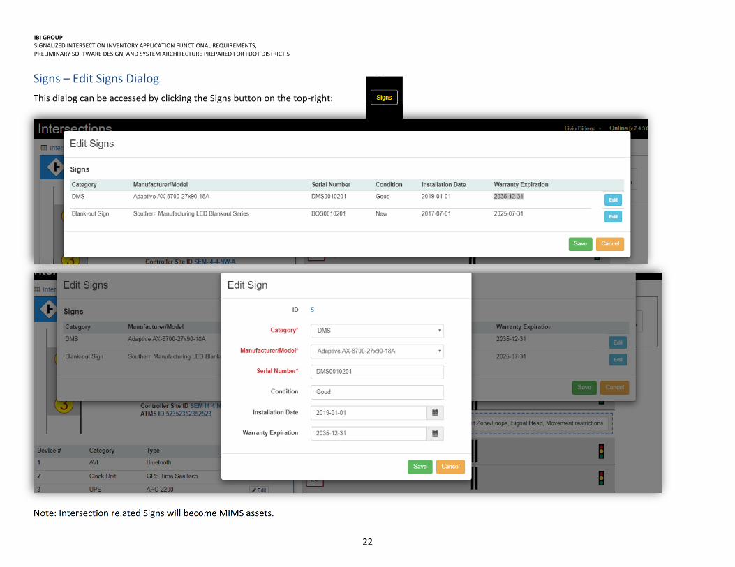
Signs – Edit Signs Dialog
This dialog can be accessed by clicking the Signs button on the top‐right:
Note: Intersection related Signs will become MIMS assets.

IBI GROUP SIGNALIZED INTERSECTION INVENTORY APPLICATION FUNCTIONAL REQUIREMENTS,
PRELIMINARY SOFTWARE DESIGN, AND SYSTEM ARCHITECTURE PREPARED FOR FDOT DISTRICT 5
23
Lane – Edit Lane Dialog
This dialog can be accessed by clicking on the Lane button like the “L2” (from the Intersection details page):
Zone / Loop – Edit Zone / Loop Dialog
This dialog can be accessed by clicking on the Edit Zone/Loop, Signal Head, Movement Restrictions (from the Intersection details page) or by clicking on the Edit button under the Zone / Loop grid within the Approach Edit dialog :

IBI GROUP SIGNALIZED INTERSECTION INVENTORY APPLICATION FUNCTIONAL REQUIREMENTS,
PRELIMINARY SOFTWARE DESIGN, AND SYSTEM ARCHITECTURE PREPARED FOR FDOT DISTRICT 5
24
Movement Restriction – Movement Restriction Dialog
This dialog can be accessed by clicking on the Edit Zone/Loop, Signal Head, Movement Restrictions (from the Intersection details page), or by clicking on the Edit button under the Movement Restriction within the Approach Edit dialog:
Note: movement restrictions can be associated with a single Lane.
IBI GROUP SIGNALIZED INTERSECTION INVENTORY APPLICATION FUNCTIONAL REQUIREMENTS,
PRELIMINARY SOFTWARE DESIGN, AND SYSTEM ARCHITECTURE PREPARED FOR FDOT DISTRICT 5
25
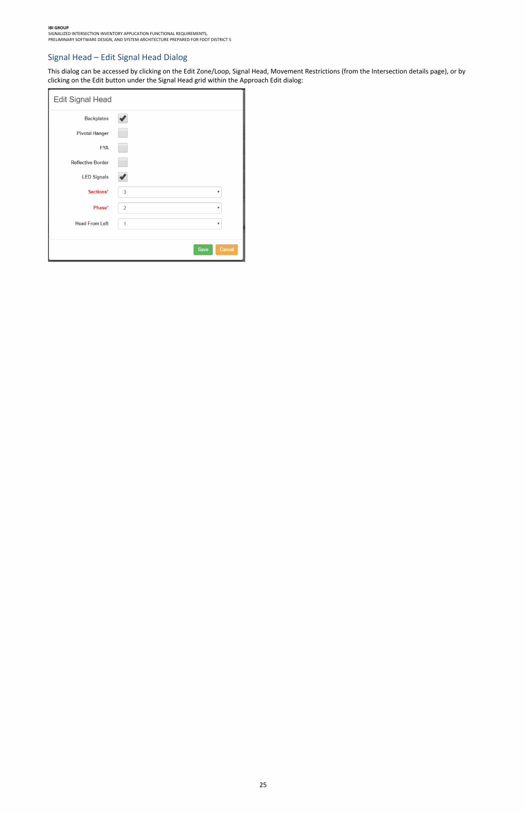
Signal Head – Edit Signal Head Dialog
This dialog can be accessed by clicking on the Edit Zone/Loop, Signal Head, Movement Restrictions (from the Intersection details page), or by clicking on the Edit button under the Signal Head grid within the Approach Edit dialog:

IBI GROUP SIGNALIZED INTERSECTION INVENTORY APPLICATION FUNCTIONAL REQUIREMENTS,
PRELIMINARY SOFTWARE DESIGN, AND SYSTEM ARCHITECTURE PREPARED FOR FDOT DISTRICT 5
26
Devices – Edit Device Dialog This dialog can be accessed by clicking on the Edit Device button from the list of Devices on the mid‐left:
Note: All Intersection related Devices will become MIMS Assets.
IBI GROUP SIGNALIZED INTERSECTION INVENTORY APPLICATION FUNCTIONAL REQUIREMENTS,
PRELIMINARY SOFTWARE DESIGN, AND SYSTEM ARCHITECTURE PREPARED FOR FDOT DISTRICT 5
27
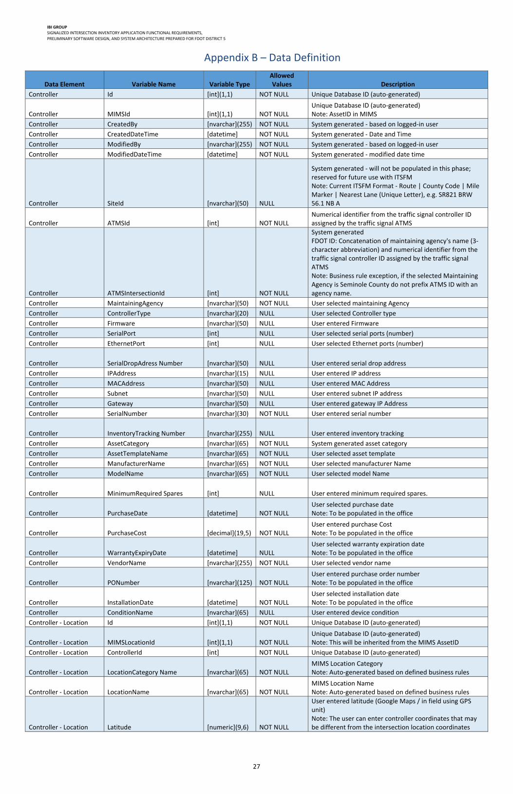
Appendix B – Data Definition
Data Element Variable Name Variable Type Allowed Values Description
Controller Id [int](1,1) NOT NULL Unique Database ID (auto‐generated)
Controller MIMSId [int](1,1) NOT NULL Unique Database ID (auto‐generated) Note: AssetID in MIMS
Controller CreatedBy [nvarchar](255) NOT NULL System generated ‐ based on logged‐in user
Controller CreatedDateTime [datetime] NOT NULL System generated ‐ Date and Time
Controller ModifiedBy [nvarchar](255) NOT NULL System generated ‐ based on logged‐in user
Controller ModifiedDateTime [datetime] NOT NULL System generated ‐ modified date time
Controller SiteId [nvarchar](50) NULL
System generated ‐ will not be populated in this phase; reserved for future use with ITSFM Note: Current ITSFM Format ‐ Route | County Code | Mile Marker | Nearest Lane (Unique Letter), e.g. SR821 BRW 56.1 NB A
Controller ATMSId [int] NOT NULL Numerical identifier from the traffic signal controller ID assigned by the traffic signal ATMS
Controller ATMSIntersectionId [int] NOT NULL
System generated FDOT ID: Concatenation of maintaining agency's name (3‐character abbreviation) and numerical identifier from the traffic signal controller ID assigned by the traffic signal ATMS Note: Business rule exception, if the selected Maintaining Agency is Seminole County do not prefix ATMS ID with an agency name.
Controller MaintainingAgency [nvarchar](50) NOT NULL User selected maintaining Agency
Controller ControllerType [nvarchar](20) NULL User selected Controller type
Controller Firmware [nvarchar](50) NULL User entered Firmware
Controller SerialPort [int] NULL User selected serial ports (number)
Controller EthernetPort [int] NULL User selected Ethernet ports (number)
Controller SerialDropAdress Number [nvarchar](50) NULL User entered serial drop address
Controller IPAddress [nvarchar](15) NULL User entered IP address
Controller MACAddress [nvarchar](50) NULL User entered MAC Address
Controller Subnet [nvarchar](50) NULL User entered subnet IP address
Controller Gateway [nvarchar](50) NULL User entered gateway IP Address
Controller SerialNumber [nvarchar](30) NOT NULL User entered serial number
Controller InventoryTracking Number [nvarchar](255) NULL User entered inventory tracking
Controller AssetCategory [nvarchar](65) NOT NULL System generated asset category
Controller AssetTemplateName [nvarchar](65) NOT NULL User selected asset template
Controller ManufacturerName [nvarchar](65) NOT NULL User selected manufacturer Name
Controller ModelName [nvarchar](65) NOT NULL User selected model Name
Controller MinimumRequired Spares [int] NULL User entered minimum required spares.
Controller PurchaseDate [datetime] NOT NULL User selected purchase date Note: To be populated in the office
Controller PurchaseCost [decimal](19,5) NOT NULL User entered purchase Cost Note: To be populated in the office
Controller WarrantyExpiryDate [datetime] NULL User selected warranty expiration date Note: To be populated in the office
Controller VendorName [nvarchar](255) NOT NULL User selected vendor name
Controller PONumber [nvarchar](125) NOT NULL User entered purchase order number Note: To be populated in the office
Controller InstallationDate [datetime] NOT NULL User selected installation date Note: To be populated in the office
Controller ConditionName [nvarchar](65) NULL User entered device condition
Controller ‐ Location Id [int](1,1) NOT NULL Unique Database ID (auto‐generated)
Controller ‐ Location MIMSLocationId [int](1,1) NOT NULL Unique Database ID (auto‐generated) Note: This will be inherited from the MIMS AssetID
Controller ‐ Location ControllerId [int] NOT NULL Unique Database ID (auto‐generated)
Controller ‐ Location LocationCategory Name [nvarchar](65) NOT NULL MIMS Location Category Note: Auto‐generated based on defined business rules
Controller ‐ Location LocationName [nvarchar](65) NOT NULL MIMS Location Name Note: Auto‐generated based on defined business rules
Controller ‐ Location Latitude [numeric](9,6) NOT NULL
User entered latitude (Google Maps / in field using GPS unit) Note: The user can enter controller coordinates that may be different from the intersection location coordinates

IBI GROUP SIGNALIZED INTERSECTION INVENTORY APPLICATION FUNCTIONAL REQUIREMENTS,
PRELIMINARY SOFTWARE DESIGN, AND SYSTEM ARCHITECTURE PREPARED FOR FDOT DISTRICT 5
28
Data Element Variable Name Variable Type Allowed Values Description
Controller ‐ Location Longitude [numeric](9,6) NOT NULL
User entered longitude (Google Maps / in field using GPS unit) Note: The user can enter controller coordinates that may be different from the intersection location coordinates
Controller ‐ Location RoadwayId [nvarchar](50) NOT NULL FDOT RCI Roadway ID Note: from FDOT Milepost Tenth of a Mile spreadsheet
Controller ‐ Location RoadwayName [nvarchar](50) NOT NULL User selected FDOT RCI Roadway Name Note: from FDOT Milepost Tenth of a Mile spreadsheet
Controller ‐ Location District [nvarchar](50) NULL User selected District
Controller ‐ Location County [nvarchar](50) NOT NULL User selected County name
Controller ‐ Location Section [nvarchar](50) NOT NULL Derived from RCI Roadway ID Number
Controller ‐ Location Milepost [nchar](10) NOT NULL System generated based on User selected Roadway
Controller ‐ Location Milemarker [nchar](10) NULL User entered Milemarker
Controller ‐ Location Route [nchar](10) NULL User entered Route name
Controller ‐ Intersection Id [int](1,1) NOT NULL Unique Database ID (auto‐generated)
Controller ‐ Intersection ControllerId [nvarchar](50) NULL Unique Database ID (auto‐generated)
Controller ‐ Intersection CreatedBy [nvarchar](255) NOT NULL System generated ‐ based on logged‐in user
Controller ‐ Intersection CreatedDateTime [datetime] NOT NULL System generated ‐ Date and Time
Controller ‐ Intersection ModifiedBy [nvarchar](255) NOT NULL System generated ‐ based on logged‐in user
Controller ‐ Intersection ModifiedDateTime [datetime] NOT NULL System generated ‐ modified date time
Controller ‐ Intersection LaneClosureRequired ForBucketTruck [nvarchar](20) NULL
User selected value related to if Lane Closure Requires a Bucket truck
Controller ‐ Intersection CabinetOffsetToTravel Lane1 [numeric](6,2) NULL User entered cabinet Offset To Travel lane 1
Controller ‐ Intersection CabinetOffsetToTravel Lane2 [numeric](6,2) NULL User entered cabinet Offset To Travel lane 2
Controller ‐ Intersection FacilityOwner [nvarchar](50) NULL User selected facility Owner
Controller ‐ Intersection IntersectionType [nvarchar](50) NULL User selected intersection Type
Controller ‐ Intersection StructureType [nvarchar](20) NULL User selected structure Type
Controller ‐ Intersection SignalType [nvarchar](20) NULL User selected signal Type
Controller ‐ Intersection Painted [nvarchar](20) NULL User selected if painted
Controller ‐ Intersection StructureNumber [numeric](10,0) NULL User entered structure Number
Controller ‐ Intersection Condition [nvarchar](10) NULL User selected condition
Controller ‐ Intersection PowerCompany [nvarchar](50) NULL User selected power company
Controller ‐ Intersection PowerServiceAddress [nvarchar](50) NOT NULL User selected power service address
Controller ‐ Intersection RRPreempt [bit] NOT NULL Boolean for Rail Road Preemption
Controller ‐ Intersection IRPreemption [bit] NULL Boolean for IR Preemption
Controller ‐ Intersection OpticalPreemption [bit] NULL Boolean for Optical Preemption
Controller ‐ Intersection CoordinatedSystem [bit] NOT NULL Boolean for Rail coordinated systems
Controller ‐ Intersection CommunicationType [nvarchar](30) NULL User selected communication Type
Controller ‐ Intersection ConnectionType [nvarchar](10) NULL User selected connection Type
Controller ‐ Intersection FiberType [nvarchar](20) NULL User selected fiber Type
Controller ‐ Intersection CabinetMount [nvarchar](20) NULL User selected cabinet Mount
Controller ‐ Intersection LeadingPedestrian Interval [bit] NULL Boolean for leading pedestrian interval
Controller ‐ Intersection PowerServiceType [nvarchar](20) NULL User selected power service type
Controller ‐ Intersection AsBuildDrawingNo [numeric](10,0) NOT NULL User entered Build Drawing number
Controller ‐ Intersection InspectorName [nvarchar](50) NULL User entered inspector name
Controller ‐ Intersection FunctionalClassification [nvarchar](20) NULL User selected functional classification
Controller ‐ Intersection ContextClassification [nvarchar](20) NULL User selected context classification
Controller ‐ Intersection FYASupported [nvarchar](20) NULL User selected FYA Supported
Controller ‐ Intersection LocatedInClearZone [nvarchar](20) NULL User selected if located In Clear Zone
Controller ‐ Intersection SpanWire [nvarchar](20) NULL User selected Span Wire
Controller ‐ Intersection DateOperational [datetime] NULL User selected operational date
Controller ‐ Intersection RespanDate [datetime] NULL User entered date based on when work was last done on the intersection
Controller ‐ Intersection GeoSequence [int] NULL User entered enumeration identifying signals in sequence
Controller ‐ Intersection FDOTSIGId [int] NULL User entered enumeration identifying internal FDOT identification
Intersection ‐ Asset Id [int](1,1) NOT NULL Unique Database ID (auto‐generated)
Intersection ‐ Asset IntersectionId [int] NOT NULL Unique Database ID (auto‐generated)
Intersection ‐ Asset MIMSAssetId [int] NOT NULL Unique Database ID (auto‐generated)
Intersection ‐ Asset CreatedBy [nvarchar](255) NOT NULL System generated ‐ based on logged‐in user
Intersection ‐ Asset CreatedDateTime [datetime] NOT NULL System generated ‐ Date and Time
Intersection ‐ Asset ModifiedBy [nvarchar](255) NOT NULL System generated ‐ based on logged‐in user
Intersection ‐ Asset ModifiedDateTime [datetime] NOT NULL System generated ‐ modified date time

IBI GROUP SIGNALIZED INTERSECTION INVENTORY APPLICATION FUNCTIONAL REQUIREMENTS,
PRELIMINARY SOFTWARE DESIGN, AND SYSTEM ARCHITECTURE PREPARED FOR FDOT DISTRICT 5
29
Data Element Variable Name Variable Type Allowed Values Description
Intersection ‐ Asset SerialNumber [nvarchar](30) NOT NULL User entered serial number
Intersection ‐ Asset InventoryTracking Number [nvarchar](255) NULL User entered inventory tracking
Intersection ‐ Asset AssetCategory [nvarchar](65) NOT NULL System generated asset category
Intersection ‐ Asset AssetTemplateName [nvarchar](65) NOT NULL User selected asset template
Intersection ‐ Asset ManufacturerName [nvarchar](65) NOT NULL User selected manufacturer Name
Intersection ‐ Asset ModelName [nvarchar](65) NOT NULL User selected model Name
Intersection ‐ Asset PurchaseDate [datetime] NOT NULL User selected purchase date Note: To be populated in the office
Intersection ‐ Asset PurchaseCost [decimal](19,5) NOT NULL User entered purchase cost Note: To be populated in the office
Intersection ‐ Asset WarrantyExpiryDate [datetime] NULL User selected warranty expiration date Note: To be populated in the office
Intersection ‐ Asset VendorName [nvarchar](255) NOT NULL User selected vendor Name
Intersection ‐ Asset PONumber [nvarchar](125) NOT NULL User entered purchase order number Note: To be populated in the office
Intersection ‐ Asset InstallationDate [datetime] NOT NULL User selected installation date Note: To be populated in the office
Intersection ‐ Asset ConditionName [nvarchar](65) NULL User entered device condition
Intersection ‐ Cabinet Id [int](1,1) NOT NULL Unique Database ID (auto‐generated)
Intersection ‐ Cabinet IntersectionId [int] NOT NULL Unique Database ID (auto‐generated)
Intersection ‐ Cabinet MIMSAssetId [int] NOT NULL Unique Database ID (auto‐generated)
Intersection ‐ Cabinet CreatedBy [nvarchar](255) NOT NULL System generated ‐ based on logged‐in user
Intersection ‐ Cabinet CreatedDateTime [datetime] NOT NULL System generated ‐ Date and Time
Intersection ‐ Cabinet ModifiedBy [nvarchar](255) NOT NULL System generated ‐ based on logged‐in user
Intersection ‐ Cabinet ModifiedDateTime [datetime] NOT NULL System generated ‐ modified date time
Intersection ‐ Cabinet CabinetType [nvarchar](50) NULL User selected cabinet Type
Intersection ‐ Cabinet CabinetSize [nvarchar](20) NULL User selected cabinet Size
Intersection ‐ Cabinet NumberOfDetectorCardRacks [int] NULL User selected number of channels
Intersection ‐ Cabinet Sunshields [bit] NOT NULL User selected number of sunshields
Intersection ‐ Cabinet KeyType [nvarchar](20) NULL Boolean for key Type
Intersection ‐ Cabinet DuctCount [int] NULL User entered duct count
Intersection ‐ Cabinet NumberOfFreeDucts [int] NULL User entered free duct count
Intersection ‐ Cabinet Filter [nvarchar](20) NULL User selected filter
Intersection ‐ Cabinet FilterSize [nvarchar](20) NULL User selected filter Size
Intersection ‐ Cabinet Coating [nvarchar](30) NULL User selected coating
Intersection ‐ Cabinet NumberOfLoadBays [int] NULL User entered number of load bays
Intersection ‐ Cabinet TransferRelays [nvarchar](50) NULL User selected transfer Relays
Intersection ‐ Cabinet SurgeArrestors [nvarchar](100) NULL User selected surge Arrestors
Intersection ‐ Cabinet LoadSwitch [nvarchar](50) NULL User selected load Switch
Intersection ‐ Cabinet LoadResistor [nvarchar](50) NULL User selected load Resistor
Intersection ‐ Cabinet SerialNumber [nvarchar](30) NOT NULL User entered serial number
Intersection ‐ Cabinet InventoryTracking Number [nvarchar](255) NULL User entered inventory tracking
Intersection ‐ Cabinet AssetCategory [nvarchar](65) NOT NULL System generated asset category
Intersection ‐ Cabinet AssetTemplateName [nvarchar](65) NOT NULL User selected asset template
Intersection ‐ Cabinet ManufacturerName [nvarchar](65) NOT NULL User selected manufacturer Name
Intersection ‐ Cabinet ModelName [nvarchar](65) NOT NULL User selected model Name
Intersection ‐ Cabinet PurchaseDate [datetime] NOT NULL User selected purchase date Note: To be populated in the office
Intersection ‐ Cabinet PurchaseCost [decimal](19,5) NOT NULL User entered purchase cost
Intersection ‐ Cabinet WarrantyExpiryDate [datetime] NULL User selected warranty expiration date Note: To be populated in the office
Intersection ‐ Cabinet VendorName [nvarchar](255) NOT NULL User selected Vendor Name
Intersection ‐ Cabinet PONumber [nvarchar](125) NOT NULL User entered purchase order number Note: To be populated in the office
Intersection ‐ Cabinet InstallationDate [datetime] NOT NULL User selected installation date Note: To be populated in the office
Intersection ‐ Cabinet ConditionName [nvarchar](65) NULL User entered device condition
Intersection ‐ Cabinet LocationCategory Name [nvarchar](65) NOT NULL MIMS Location Category Note: Auto‐generated based on defined business rules
Intersection ‐ Cabinet LocationName [nvarchar](65) NOT NULL MIMS Location Name Note: Auto‐generated based on defined business rules

IBI GROUP SIGNALIZED INTERSECTION INVENTORY APPLICATION FUNCTIONAL REQUIREMENTS,
PRELIMINARY SOFTWARE DESIGN, AND SYSTEM ARCHITECTURE PREPARED FOR FDOT DISTRICT 5
30
Data Element Variable Name Variable Type Allowed Values Description
Intersection ‐ Cabinet Latitude [numeric](9,6) NOT NULL
User entered latitude (Google Maps / in field using GPS unit) Note: The user can enter controller coordinates that may be different from the intersection location coordinates
Intersection ‐ Cabinet Longitude [numeric](9,6) NOT NULL
User entered longitude (Google Maps / in field using GPS unit) Note: The user can enter controller coordinates that may be different from the intersection location coordinates
Intersection ‐ Cabinet GeneratorHookUp [bit] NULL Boolean for Generator at Intersection
Intersection ‐ Location Id [int](1,1) NOT NULL Unique Database ID (auto‐generated)
Intersection ‐ Location MIMSLocationId [int](1,1) NOT NULL Unique Database ID (auto‐generated)
Intersection ‐ Location IntersectionId [int] NOT NULL Unique Database ID (auto‐generated)
Intersection ‐ Location CreatedBy [nvarchar](255) NOT NULL System generated ‐ based on logged‐in user
Intersection ‐ Location CreatedDateTime [datetime] NOT NULL System generated ‐ Date and Time
Intersection ‐ Location ModifiedBy [nvarchar](255) NOT NULL System generated ‐ based on logged‐in user
Intersection ‐ Location ModifiedDateTime [datetime] NOT NULL System generated ‐ modified date time
Intersection ‐ Location Latitude [numeric](9,6) NOT NULL
User entered latitude (Google Maps / in field using GPS unit) Note: The user can enter controller coordinates that may be different from the intersection location coordinates
Intersection ‐ Location Longitude [numeric](9,6) NOT NULL
User entered longitude (Google Maps / in field using GPS unit) Note: The user can enter controller coordinates that may be different from the intersection location coordinates
Intersection ‐ Location RoadwayId(s) [nvarchar](50) NOT NULL FDOT RCI Roadway ID Note: from FDOT Milepost Tenth of a Mile spreadsheet
Intersection ‐ Location RoadwayName(s) [nvarchar](50) NOT NULL User selected FDOT RCI Roadway Name Note: from FDOT Milepost Tenth of a Mile spreadsheet
Intersection ‐ Location County [nvarchar](50) NOT NULL User selected County name
Intersection ‐ Location County2 [nvarchar](50) NULL User selected County name for Intersections that share county lines
Intersection ‐ Location District [nvarchar](50) NULL User selected District
Intersection ‐ Location Section [nvarchar](50) NOT NULL Derived from RCI Roadway ID Number
Intersection ‐ Location Milepost [nchar](10) NOT NULL System generated based on User selected Roadway
Intersection ‐ Location Milemarker [nchar](10) NULL User entered Milemarker
Intersection ‐ Location Route [nchar](10) NULL User entered Route name
Approach Id [int](1,1) NOT NULL Unique Database ID (auto‐generated)
Approach IntersectionId [int] NOT NULL Unique Database ID (auto‐generated)
Approach CreatedBy [nvarchar](255) NOT NULL System generated ‐ based on logged‐in user
Approach CreatedDateTime [datetime] NOT NULL System generated ‐ Date and Time
Approach ModifiedBy [nvarchar](255) NOT NULL System generated ‐ based on logged‐in user
Approach ModifiedDateTime [datetime] NOT NULL System generated ‐ modified date time
Approach RoadwayId [nvarchar](50) NOT NULL FDOT RCI Roadway ID Note: from FDOT Milepost Tenth of a Mile spreadsheet
Approach RoadwayName [nvarchar](50) NOT NULL User selected FDOT RCI Roadway Name Note: from FDOT Milepost Tenth of a Mile spreadsheet
Approach Direction [numeric](9,6) NOT NULL User selected direction from compass
Approach SpeedLimit [numeric](6,0) NULL User entered speed Limit
Approach ApproachGrade [numeric](6,2) NULL User entered approach Grade
Approach SchoolZone [bit] NOT NULL Boolean for school zone
Approach ApproachOwner [nvarchar](50) NULL User selected approach owner
Approach NumberOfThroughLanes [nvarchar](20) NULL User entered number of through lanes
Approach NoUTurn [bit] NOT NULL Boolean for no U ‐ Turns
Approach NoLeft [bit] NOT NULL Boolean for no lefts
Approach NoThrough [bit] NOT NULL Boolean for no through
Approach NoRight [bit] NOT NULL Boolean for no right
Approach Preemption [bit] NOT NULL Boolean if preemption
Approach CountdownLEDPedestrianSignal [bit] NOT NULL Boolean for countdown LED Pedestrian signals
Approach LEDPedestrianSignal [bit] NOT NULL Boolean for LED Pedestrian signals
Approach CountdownPedestrianSignal [bit] NOT NULL Boolean for countdown pedestrian signals
Approach PedestrianSignal [bit] NOT NULL Boolean for pedestrian signal
Approach StructureNumber [nvarchar](30) NULL User entered structure Number
Approach SignalType [nvarchar](20) NULL User selected signal type
Approach SignalCondition [nvarchar](20) NULL User selected signal condition
Approach CrossingDistance [numeric](6,0) NULL User entered crossing Distance
Approach PartOfTSP [bit] NOT NULL Boolean for part of TSP

IBI GROUP SIGNALIZED INTERSECTION INVENTORY APPLICATION FUNCTIONAL REQUIREMENTS,
PRELIMINARY SOFTWARE DESIGN, AND SYSTEM ARCHITECTURE PREPARED FOR FDOT DISTRICT 5
31
Data Element Variable Name Variable Type Allowed Values Description
Approach ‐ Asset Id [int](1,1) NOT NULL Unique Database ID (auto‐generated)
Approach ‐ Asset ApproachId [int] NOT NULL Unique Database ID (auto‐generated)
Approach ‐ Asset MIMSAssetID [int](1,1) NOT NULL Unique Database ID (auto‐generated)
Approach ‐ Asset CreatedBy [nvarchar](255) NOT NULL System generated ‐ based on logged‐in user
Approach ‐ Asset CreatedDateTime [datetime] NOT NULL System generated ‐ Date and Time
Approach ‐ Asset ModifiedBy [nvarchar](255) NOT NULL System generated ‐ based on logged‐in user
Approach ‐ Asset ModifiedDateTime [datetime] NOT NULL System generated ‐ modified date time
Approach ‐ Asset SerialNumber [nvarchar](30) NOT NULL User entered serial number
Approach ‐ Asset InventoryTracking Number [nvarchar](255) NULL User entered inventory tracking
Approach ‐ Asset AssetTemplateName [nvarchar](65) NOT NULL User selected asset template
Approach ‐ Asset ManufacturerName [nvarchar](65) NOT NULL User selected manufacturer Name
Approach ‐ Asset ModelName [nvarchar](65) NOT NULL User selected model Name
Approach ‐ Asset PurchaseDate [datetime] NOT NULL User selected purchase date Note: To be populated in the office
Approach ‐ Asset PurchaseCost [decimal](19,5) NOT NULL User entered purchase cost Note: To be populated in the office
Approach ‐ Asset WarrantyExpiryDate [datetime] NULL User selected warranty expiration date Note: To be populated in the office
Approach ‐ Asset VendorName [nvarchar](255) NOT NULL User selected Vendor Name
Approach ‐ Asset PONumber [nvarchar](125) NOT NULL User entered purchase order number Note: To be populated in the office
Approach ‐ Asset InstallationDate [datetime] NOT NULL User selected installation date Note: To be populated in the office
Approach ‐ Asset ConditionName [nvarchar](65) NULL User entered device condition
Approach ‐ Asset ExtendedProperty Name [nvarchar](65) NULL
Used to include all asset attributes, that are not core MIMS asset attributes, including: Zone/Loop Channel Zone/Loop Phase Zone/Loop Distance to Stop bar Zone/Loop Slot Number Zone/Loop Length
Approach ‐ Asset ExtendedPropertyValue [nvarchar](65) NULL User entered asset attribute
Lane Id [int](1,1) NOT NULL Unique Database ID (auto‐generated)
Lane ApproachId [int](1,1) NOT NULL Unique Database ID (auto‐generated)
Lane CreatedBy [nvarchar](255) NOT NULL System generated ‐ based on logged‐in user
Lane CreatedDateTime [datetime] NOT NULL System generated ‐ Date and Time
Lane ModifiedBy [nvarchar](255) NOT NULL System generated ‐ based on logged‐in user
Lane ModifiedDateTime [datetime] NOT NULL System generated ‐ modified date time
Lane ApproachId [int] NOT NULL Unique Database ID (auto‐generated)
Lane LaneType [nvarchar](20) NULL User selected lane Type
Lane Width [numeric](6,2) NOT NULL User entered lane width
Lane Length [numeric](10,2) NULL User entered lane length
Lane NumberFromLeft [int] NOT NULL User entered number of lanes from left
Lane TurnByLength [numeric](10,2) NULL User entered turn by length
Lane ‐ Detector ApproachId [int] NOT NULL Unique Database ID (auto‐generated)
Lane ‐ Detector LaneId [int] NOT NULL Unique Database ID (auto‐generated)
Lane ‐ Detector CreatedBy [nvarchar](255) NOT NULL System generated ‐ based on logged‐in user
Lane ‐ Detector CreatedDateTime [datetime] NOT NULL System generated ‐ Date and Time
Lane ‐ Detector ModifiedBy [nvarchar](255) NOT NULL System generated ‐ based on logged‐in user
Lane ‐ Detector ModifiedDateTime [datetime] NOT NULL System generated ‐ modified date time
Lane ‐ Detector Type [nvarchar](20) NOT NULL User selected type
Lane ‐ Detector Channel [int] NULL User entered number of channels
Lane ‐ Detector Phase [nvarchar](5) NULL User selected phase
Lane ‐ Detector DistanceToStopbar [numeric](6,2) NOT NULL User entered distance to stop bar
Lane ‐ Detector SlotNumber [int] NULL User selected number of slots
Lane ‐ Movement Restriction Id [int](1,1) NOT NULL Unique Database ID (auto‐generated)
Lane ‐ Movement Restriction LaneId [int] NOT NULL Unique Database ID (auto‐generated)
Lane ‐ Movement Restriction CreatedBy [nvarchar](255) NOT NULL System generated ‐ based on logged‐in user
Lane ‐ Movement Restriction CreatedDateTime [datetime] NOT NULL System generated ‐ Date and Time
Lane ‐ Movement Restriction ModifiedBy [nvarchar](255) NOT NULL System generated ‐ based on logged‐in user

IBI GROUP SIGNALIZED INTERSECTION INVENTORY APPLICATION FUNCTIONAL REQUIREMENTS,
PRELIMINARY SOFTWARE DESIGN, AND SYSTEM ARCHITECTURE PREPARED FOR FDOT DISTRICT 5
32
Data Element Variable Name Variable Type Allowed Values Description
Lane ‐ Movement Restriction ModifiedDateTime [datetime] NOT NULL System generated ‐ modified date time
Lane ‐ Movement Restriction Type [nvarchar](100) NOT NULL User selected type
Lane ‐ Movement Restriction StartTime [nvarchar](30) NOT NULL User selected start time
Lane ‐ Movement Restriction EndTime [nvarchar](30) NOT NULL User selected end time
Lane ‐ Movement Restriction DayOfWeek [nvarchar](20) NOT NULL User selected day of week
Lane ‐ Signal Head Id [int](1,1) NOT NULL Unique Database ID (auto‐generated)
Lane ‐ Signal Head LaneId [int] NOT NULL Unique Database ID (auto‐generated)
Lane ‐ Signal Head CreatedBy [nvarchar](255) NOT NULL System generated ‐ based on logged‐in user
Lane ‐ Signal Head CreatedDateTime [datetime] NOT NULL System generated ‐ Date and Time
Lane ‐ Signal Head ModifiedBy [nvarchar](255) NOT NULL System generated ‐ based on logged‐in user
Lane ‐ Signal Head ModifiedDateTime [datetime] NOT NULL System generated ‐ modified date time
Lane ‐ Signal Head FDOTSignalID [int] NOT NULL User entered FDOT Signal ID Note: To be populated in the office
Lane ‐ Signal Head Backplates [bit] NOT NULL Boolean for back‐plates
Lane ‐ Signal Head PivotalHanger [bit] NOT NULL Boolean for pivotal hangers
Lane ‐ Signal Head FYA [bit] NOT NULL Boolean for FYA
Lane ‐ Signal Head ReflectiveBorder [bit] NOT NULL Boolean for reflective borders
Lane ‐ Signal Head LEDSignals [bit] NOT NULL Boolean for LED Signals
Lane ‐ Signal Head Sections [int] NULL User entered number of sections
Lane ‐ Signal Head Phase [nvarchar](5) NOT NULL User selected Signal Phase
Lane ‐ Signal Head Phase2 [nvarchar](5) NULL User selected Signal Phase

IBI GROUP SIGNALIZED INTERSECTION INVENTORY APPLICATION FUNCTIONAL REQUIREMENTS,
PRELIMINARY SOFTWARE DESIGN, AND SYSTEM ARCHITECTURE PREPARED FOR FDOT DISTRICT 5
33
Appendix C – Intersection Inventory API
Overview The MIMS Intersection Inventory External API provides a mechanism for external systems to retrieve data for traffic intersections and associated assets being tracked and managed in MIMS.
Security The MIMS Intersection Inventory External API will be deployed on a server using TLS over HTTPS, providing a secured link between systems. The API uses OAuth2 and tokens to manage user authorization. A bearer token can be obtained by POST to /oauth2/token with username, password, and “grant_type=password” supplied in “x‐ www‐form‐urlencoded” format via the post payload.

IBI GROUP SIGNALIZED INTERSECTION INVENTORY APPLICATION FUNCTIONAL REQUIREMENTS,
PRELIMINARY SOFTWARE DESIGN, AND SYSTEM ARCHITECTURE PREPARED FOR FDOT DISTRICT 5
34
API Definition
The following table lists the resources (API calls) available to the client along with descriptions of those resources. Full details follow for each individual resource, including the names, data types, and descriptions of all available fields. Note: For Phase I testing, the API can be assessed at: https://www.ibi‐mobile.solutions/intersections/api/Token
All API are available, with the exception of GET intersectionByModifiedDateTime/{datetime}, and GET intersectionBySignalId/{signalId}
Required Keys: username: XXXXX, password: XXXXX, and grant_type: XXXXX
Final API Documentation and Payload data will be included as part of the software design and development Phase 2.
Resource Description
GET allIntersections Retrieves a summary of active intersections in the system
GET intersectionByModifiedDateTime/{datetime} Retrieves a summary of active intersections in the system that have been modified after a specified date‐time
GET intersectionByDistrict/{district} Retrieves a summary of active intersections in the system for a specific District name
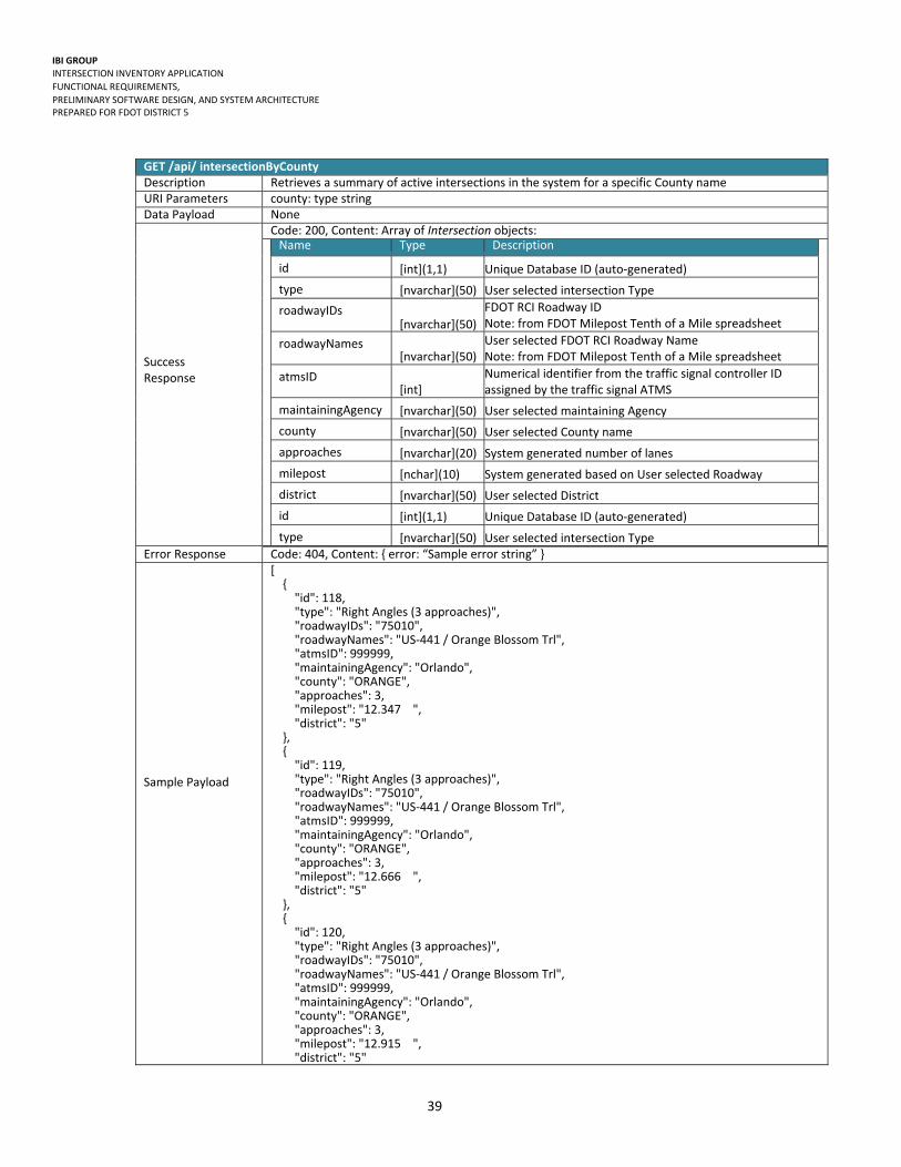
GET intersectionByCounty/{county} Retrieves a summary of active intersections in the system for a specific County name
GET intersectionByRoadway/{majorRoadway} Retrieves a summary of active intersections in the system for a specific Roadway name
GET intersectionBySignalId/{signalId} Retrieves a specific intersection, including data related to parent controller and associated approaches, lanes and devices for a specific Signal ID
GET intersection/{id} Retrieves a specific intersection, including data related to parent controller and associated approaches, lanes and devices for a specific Intersection ID

IBI GROUP INTERSECTION INVENTORY APPLICATION
FUNCTIONAL REQUIREMENTS,
PRELIMINARY SOFTWARE DESIGN, AND SYSTEM ARCHITECTURE PREPARED FOR FDOT DISTRICT 5
35
GET /api/ allIntersections Description Retrieves a summary of active intersections in the system URI Parameters None Data Payload None
Success Response
Code: 200, Content: Array of Intersection objects:
Variable Name Type Description
id [int](1,1) Unique Database ID (auto‐generated)
type [nvarchar](50) User selected intersection Type
roadwayIDs
[nvarchar](50)
FDOT RCI Roadway ID Note: from FDOT Milepost Tenth of a Mile spreadsheet
roadwayNames
[nvarchar](50)
User selected FDOT RCI Roadway Name Note: from FDOT Milepost Tenth of a Mile spreadsheet
atmsID [int]
Numerical identifier from the traffic signal controller ID assigned by the traffic signal ATMS
maintainingAgency [nvarchar](50) User selected maintaining Agency
county [nvarchar](50) User selected County name
approaches [nvarchar](20) System generated number of lanes
milepost [nchar](10) System generated based on User selected Roadway
district [nvarchar](50) User selected District
Error Response Code: 404, Content: { error: “Sample error string” }
Sample Payload
[ { "id": 1, "type": "Right Angles (3 approaches)", "roadwayIDs": "79110000", "roadwayNames": "I‐4", "atmsID": 999999, "maintainingAgency": "Seminole County", "county": "SEMINOLE", "approaches": 3, "milepost": "99 ", "district": "5" }, { "id": 2, "type": "Right Angles (3 approaches)", "roadwayIDs": "36210030", "roadwayNames": "I‐75", "atmsID": 999999, "maintainingAgency": "Marion County", "county": "MARION", "approaches": 3, "milepost": "335 ", "district": "5" }, { "id": 3, "type": "Right Angles (2 approaches)", "roadwayIDs": "36100000", "roadwayNames": "SR‐200 / College Rd / SW 10th St", "atmsID": 999999, "maintainingAgency": "Ocala", "county": "MARION", "approaches": 2, "milepost": "NULL ", "district": "5" }, { "id": 4, "type": "Right Angles (3 approaches)", "roadwayIDs": "36100000", "roadwayNames": "SR‐200 / College Rd / SW 10th St", "atmsID": 999999,

IBI GROUP INTERSECTION INVENTORY APPLICATION
FUNCTIONAL REQUIREMENTS,
PRELIMINARY SOFTWARE DESIGN, AND SYSTEM ARCHITECTURE PREPARED FOR FDOT DISTRICT 5
36
"maintainingAgency": "Marion County", "county": "MARION", "approaches": 3, "milepost": "NULL ", "district": "5" }, { "id": 5, "type": "Right Angles (3 approaches)", "roadwayIDs": "36100000", "roadwayNames": "SR‐200 / College Rd / SW 10th St", "atmsID": 999999, "maintainingAgency": "Marion County", "county": "MARION", "approaches": 3, "milepost": "NULL ", "district": "5" }, { "id": 6, "type": "Right Angles (3 approaches)", "roadwayIDs": "36100000", "roadwayNames": "SR‐200 / College Rd / SW 10th St", "atmsID": 999999, "maintainingAgency": "Ocala", "county": "MARION", "approaches": 3, "milepost": "NULL ", "district": "5" }, { "id": 7, "type": "Right Angles (3 approaches)", "roadwayIDs": "36100000", "roadwayNames": "SR‐200 / College Rd / SW 10th St", "atmsID": 999999, "maintainingAgency": "Ocala", "county": "MARION", "approaches": 3, "milepost": "NULL ", "district": "5" }, { "id": 148, "type": "Right Angles (2 approaches)", "roadwayIDs": "75060", "roadwayNames": "SR‐50/600 (Colonial Dr.)", "atmsID": 999999, "maintainingAgency": "Orlando", "county": "ORANGE", "approaches": 2, "milepost": "1.135 ", "district": "5" }]

IBI GROUP INTERSECTION INVENTORY APPLICATION
FUNCTIONAL REQUIREMENTS,
PRELIMINARY SOFTWARE DESIGN, AND SYSTEM ARCHITECTURE PREPARED FOR FDOT DISTRICT 5
37
GET /api/ intersectionByDistrict Description Retrieves a summary of active intersections in the system for a specific District name URI Parameters district: type string Data Payload None
Success Response
Code: 200, Content: Array of Intersection objects:
Name Type Description
id [int](1,1) Unique Database ID (auto‐generated)
type [nvarchar](50) User selected intersection Type
roadwayIDs [nvarchar](50)
FDOT RCI Roadway ID Note: from FDOT Milepost Tenth of a Mile spreadsheet
roadwayNames [nvarchar](50)
User selected FDOT RCI Roadway Name Note: from FDOT Milepost Tenth of a Mile spreadsheet
atmsID [int]
Numerical identifier from the traffic signal controller ID assigned by the traffic signal ATMS
maintainingAgency [nvarchar](50) User selected maintaining Agency
county [nvarchar](50) User selected County name
approaches [nvarchar](20) System generated number of lanes
milepost [nchar](10) System generated based on User selected Roadway
district [nvarchar](50) User selected District
Error Response Code: 404, Content: { error: “Sample error string” }
Sample Payload
[ { "id": 1, "type": "Right Angles (3 approaches)", "roadwayIDs": "79110000", "roadwayNames": "I‐4", "atmsID": 999999, "maintainingAgency": "Seminole County", "county": "SEMINOLE", "approaches": 3, "milepost": "99 ", "district": "5" }, { "id": 2, "type": "Right Angles (3 approaches)", "roadwayIDs": "36210030", "roadwayNames": "I‐75", "atmsID": 999999, "maintainingAgency": "Marion County", "county": "MARION", "approaches": 3, "milepost": "335 ", "district": "5" }, { "id": 3, "type": "Right Angles (2 approaches)", "roadwayIDs": "36100000", "roadwayNames": "SR‐200 / College Rd / SW 10th St", "atmsID": 999999, "maintainingAgency": "Ocala", "county": "MARION", "approaches": 2, "milepost": "NULL ", "district": "5" }, { "id": 4, "type": "Right Angles (3 approaches)", "roadwayIDs": "36100000",
IBI GROUP INTERSECTION INVENTORY APPLICATION
FUNCTIONAL REQUIREMENTS,
PRELIMINARY SOFTWARE DESIGN, AND SYSTEM ARCHITECTURE PREPARED FOR FDOT DISTRICT 5
38
"roadwayNames": "SR‐200 / College Rd / SW 10th St", "atmsID": 999999, "maintainingAgency": "Marion County", "county": "MARION", "approaches": 3, "milepost": "NULL ", "district": "5" },
{ "id": 146, "type": "Right Angles (3 approaches)", "roadwayIDs": "75060", "roadwayNames": "SR‐50(600) Colonial Dr.", "atmsID": 999999, "maintainingAgency": "Orlando", "county": "ORANGE", "approaches": 3, "milepost": ".139 ", "district": "5" }, { "id": 147, "type": "Right Angles (2 approaches)", "roadwayIDs": "75060", "roadwayNames": "SR‐50 /600(Colonial Dr.)", "atmsID": 999999, "maintainingAgency": "Orlando", "county": "ORANGE", "approaches": 2, "milepost": ".996 ", "district": "5" } ]
IBI GROUP INTERSECTION INVENTORY APPLICATION
FUNCTIONAL REQUIREMENTS,
PRELIMINARY SOFTWARE DESIGN, AND SYSTEM ARCHITECTURE PREPARED FOR FDOT DISTRICT 5
39
GET /api/ intersectionByCounty Description Retrieves a summary of active intersections in the system for a specific County name URI Parameters county: type string Data Payload None
Success Response
Code: 200, Content: Array of Intersection objects:
Name Type Description
id [int](1,1) Unique Database ID (auto‐generated)
type [nvarchar](50) User selected intersection Type
roadwayIDs [nvarchar](50)
FDOT RCI Roadway ID Note: from FDOT Milepost Tenth of a Mile spreadsheet
roadwayNames [nvarchar](50)
User selected FDOT RCI Roadway Name Note: from FDOT Milepost Tenth of a Mile spreadsheet
atmsID [int]
Numerical identifier from the traffic signal controller ID assigned by the traffic signal ATMS
maintainingAgency [nvarchar](50) User selected maintaining Agency
county [nvarchar](50) User selected County name
approaches [nvarchar](20) System generated number of lanes
milepost [nchar](10) System generated based on User selected Roadway
district [nvarchar](50) User selected District
id [int](1,1) Unique Database ID (auto‐generated)
type [nvarchar](50) User selected intersection Type
Error Response Code: 404, Content: { error: “Sample error string” }
Sample Payload
[ { "id": 118, "type": "Right Angles (3 approaches)", "roadwayIDs": "75010", "roadwayNames": "US‐441 / Orange Blossom Trl", "atmsID": 999999, "maintainingAgency": "Orlando", "county": "ORANGE", "approaches": 3, "milepost": "12.347 ", "district": "5" }, { "id": 119, "type": "Right Angles (3 approaches)", "roadwayIDs": "75010", "roadwayNames": "US‐441 / Orange Blossom Trl", "atmsID": 999999, "maintainingAgency": "Orlando", "county": "ORANGE", "approaches": 3, "milepost": "12.666 ", "district": "5" }, { "id": 120, "type": "Right Angles (3 approaches)", "roadwayIDs": "75010", "roadwayNames": "US‐441 / Orange Blossom Trl", "atmsID": 999999, "maintainingAgency": "Orlando", "county": "ORANGE", "approaches": 3, "milepost": "12.915 ", "district": "5"

IBI GROUP INTERSECTION INVENTORY APPLICATION
FUNCTIONAL REQUIREMENTS,
PRELIMINARY SOFTWARE DESIGN, AND SYSTEM ARCHITECTURE PREPARED FOR FDOT DISTRICT 5
40
},
{ "id": 146, "type": "Right Angles (3 approaches)", "roadwayIDs": "75060", "roadwayNames": "SR‐50(600) Colonial Dr.", "atmsID": 999999, "maintainingAgency": "Orlando", "county": "ORANGE", "approaches": 3, "milepost": ".139 ", "district": "5" }, { "id": 147, "type": "Right Angles (2 approaches)", "roadwayIDs": "75060", "roadwayNames": "SR‐50 /600(Colonial Dr.)", "atmsID": 999999, "maintainingAgency": "Orlando", "county": "ORANGE", "approaches": 2, "milepost": ".996 ", "district": "5" }, { "id": 148, "type": "Right Angles (2 approaches)", "roadwayIDs": "75060", "roadwayNames": "SR‐50/600 (Colonial Dr.)", "atmsID": 999999, "maintainingAgency": "Orlando", "county": "ORANGE", "approaches": 2, "milepost": "1.135 ", "district": "5" } ]

IBI GROUP INTERSECTION INVENTORY APPLICATION
FUNCTIONAL REQUIREMENTS,
PRELIMINARY SOFTWARE DESIGN, AND SYSTEM ARCHITECTURE PREPARED FOR FDOT DISTRICT 5
41
GET /api/ intersectionByRoadway Description Retrieves a summary of active intersections in the system for a specific Roadway name URI Parameters RoadwayId: type string Data Payload None
Success Response
Code: 200, Content: Array of Intersection objects:
Name Type Description
id [int](1,1) Unique Database ID (auto‐generated)
type [nvarchar](50) User selected intersection Type
roadwayIDs [nvarchar](50)
FDOT RCI Roadway ID Note: from FDOT Milepost Tenth of a Mile spreadsheet
roadwayNames [nvarchar](50)
User selected FDOT RCI Roadway Name Note: from FDOT Milepost Tenth of a Mile spreadsheet
atmsID [int]
Numerical identifier from the traffic signal controller ID assigned by the traffic signal ATMS
maintainingAgency [nvarchar](50) User selected maintaining Agency
county [nvarchar](50) User selected County name
approaches [nvarchar](20) System generated number of lanes
milepost [nchar](10) System generated based on User selected Roadway
district [nvarchar](50) User selected District
id [int](1,1) Unique Database ID (auto‐generated)
type [nvarchar](50) User selected intersection Type
Error Response Code: 404, Content: { error: “Sample error string” }
Sample Payload
[ { "id": 3, "type": "Right Angles (2 approaches)", "roadwayIDs": "36100000", "roadwayNames": "SR‐200 / College Rd / SW 10th St", "atmsID": 999999, "maintainingAgency": "Ocala", "county": "MARION", "approaches": 2, "milepost": "NULL ", "district": "5" }, { "id": 4, "type": "Right Angles (3 approaches)", "roadwayIDs": "36100000", "roadwayNames": "SR‐200 / College Rd / SW 10th St", "atmsID": 999999, "maintainingAgency": "Marion County", "county": "MARION", "approaches": 3, "milepost": "NULL ", "district": "5" }, { "id": 5, "type": "Right Angles (3 approaches)", "roadwayIDs": "36100000", "roadwayNames": "SR‐200 / College Rd / SW 10th St", "atmsID": 999999, "maintainingAgency": "Marion County", "county": "MARION", "approaches": 3, "milepost": "NULL ",

IBI GROUP INTERSECTION INVENTORY APPLICATION
FUNCTIONAL REQUIREMENTS,
PRELIMINARY SOFTWARE DESIGN, AND SYSTEM ARCHITECTURE PREPARED FOR FDOT DISTRICT 5
42
"district": "5" }, { "id": 6, "type": "Right Angles (3 approaches)", "roadwayIDs": "36100000", "roadwayNames": "SR‐200 / College Rd / SW 10th St", "atmsID": 999999, "maintainingAgency": "Ocala", "county": "MARION", "approaches": 3, "milepost": "NULL ", "district": "5" }, {
}, { "id": 17, "type": "Right Angles (3 approaches)", "roadwayIDs": "36100000", "roadwayNames": "SR‐200 / College Rd / SW 10th St", "atmsID": 999999, "maintainingAgency": "Ocala", "county": "MARION", "approaches": 3, "milepost": "NULL ", "district": "5" }, { "id": 18, "type": "Right Angles (3 approaches)", "roadwayIDs": "36100000", "roadwayNames": "SR‐200 / College Rd / SW 10th St", "atmsID": 999999, "maintainingAgency": "Ocala", "county": "MARION", "approaches": 3, "milepost": "NULL ", "district": "5" }, { "id": 19, "type": "Right Angles (3 approaches)", "roadwayIDs": "36100000", "roadwayNames": "SR‐200 / College Rd / SW 10th St", "atmsID": 999999, "maintainingAgency": "Marion County", "county": "MARION", "approaches": 3, "milepost": "NULL ", "district": "5" } ]

IBI GROUP INTERSECTION INVENTORY APPLICATION
FUNCTIONAL REQUIREMENTS,
PRELIMINARY SOFTWARE DESIGN, AND SYSTEM ARCHITECTURE PREPARED FOR FDOT DISTRICT 5
43
GET /api/ intersection
Description Retrieves a specific intersection, including data related to associated approaches, lanes and devices
URI Parameters id: type int Data Payload None Success Response
Code: 200, Content: Array of Intersection objects: Name Type Description
Intersection[]
id [int](1,1) Unique Database ID (auto‐generated)
type [nvarchar](50) User selected intersection Type
roadwayIDs [nvarchar](50)
FDOT RCI Roadway ID Note: from FDOT Milepost Tenth of a Mile spreadshee
roadwayNames [nvarchar](50)
User selected FDOT RCI Roadway Name Note: from FDOT Milepost Tenth of a Mile spreadshee
atmsID [int]
Numerical identifier from the traffic signal controller Iassigned by the traffic signal ATMS
maintainingAgency [nvarchar](50) User selected maintaining Agency
county [nvarchar](50) User selected County name
approaches [nvarchar](20) System generated number of lanes
milepost [nchar](10) System generated based on User selected Roadway
district [nvarchar](50) User selected District
laneClosureRequiredForBucket [nvarchar](20)
User selected value related to if Lane Closure Requirea Bucket truck
cabinetOffsetToTravelLane1 [numeric](6,2) User entered cabinet Offset To Travel lane 1
CabinetOffsetToTravel Lane2 [numeric](6,2) User entered cabinet Offset To Travel lane 2
FacilityOwner [nvarchar](50) User selected facility Owner
structureType [nvarchar](20) User selected structure Type
SignalType [nvarchar](20) User selected signal Type
painted [nvarchar](20) User selected if painted
StructureNumber [numeric](10,0) User entered structure Number
condition [nvarchar](10) User selected condition
powerCompany [nvarchar](50) User selected power company
rrPreempt [bit] Boolean for Rail Road Preemption
irPreemption [bit] Boolean for IR Preemption
opticalPreemption [bit] Boolean for Optical Preemption
coordinatedSystem [bit] Boolean for Rail coordinated systems
communicationType [nvarchar](30) User selected communication Type
connectionType [nvarchar](10) User selected connection Type
fiberType [nvarchar](20) User selected fiber Type
cabinetMount [nvarchar](20) User selected cabinet Mount
leadingPedestrianInterval [bit] Boolean for leading pedestrian interval
powerServiceType [nvarchar](20) User selected power service type
asBuildDrawingNo [numeric](10,0) User entered Build Drawing number
AsBuildDrawingNo [numeric](10,0) User entered Build Drawing number

IBI GROUP INTERSECTION INVENTORY APPLICATION
FUNCTIONAL REQUIREMENTS,
PRELIMINARY SOFTWARE DESIGN, AND SYSTEM ARCHITECTURE PREPARED FOR FDOT DISTRICT 5
44
InspectorName [nvarchar](50) User entered inspector name
FunctionalClassification [nvarchar](20) User selected functional classification
ContextClassification [nvarchar](20) User selected context classification
FYASupported [nvarchar](20) User selected FYA Supported
LocatedInClearZone [nvarchar](20) User selected if located In Clear Zone
SpanWire [nvarchar](20) User selected Span Wire
DateOperational [datetime] User selected operational date
RespanDate [datetime] User entered date based on when work was last done on the intersection
GeoSequence [int] User entered enumeration identifying signals in sequence
FDOTSIGId [int] User entered enumeration identifying internal FDOT identification
assets[]
assetID [int] Unique Database ID (auto‐generated)
manufacturer [nvarchar](65) User selected manufacturer Name
model [nvarchar](65) User selected model Name
assetCategory [nvarchar](65) System generated asset category
vendor [nvarchar](255) User selected vendor Name
locationCategory [nvarchar](65)
MIMS Location Category Note: Auto‐generated based on defined business rules
locationName [nvarchar](65)
MIMS Location Name Note: Auto‐generated based on defined business rules
latitude
[numeric](9,6)
User entered latitude (Google Maps / in field using GPS unit) Note: The user can enter controller coordinates that may be different from the intersection location coordinates
longitude [numeric](9,6) User entered longitude (Google Maps / in field using GPS unit) Note: The user can enter controller coordinates that may be different from the intersection location coordinates
Approaches[]
roadwayID [nvarchar](50)
FDOT RCI Roadway ID Note: from FDOT Milepost Tenth of a Mile spreadsheet
roadwayName [nvarchar](50)
User selected FDOT RCI Roadway Name Note: from FDOT Milepost Tenth of a Mile spreadsheet
direction [numeric](9,6) User selected direction from compass
speedLimit [numeric](6,0) User entered speed Limit
approachGrade [numeric](6,2) User entered approach Grade
schoolZone [bit] Boolean for school zone
numberOfThroughLanes [nvarchar](20) User entered number of through lanes
noUTurn [bit] Boolean for no U ‐ Turns
noLeft [bit] Boolean for no lefts

IBI GROUP INTERSECTION INVENTORY APPLICATION
FUNCTIONAL REQUIREMENTS,
PRELIMINARY SOFTWARE DESIGN, AND SYSTEM ARCHITECTURE PREPARED FOR FDOT DISTRICT 5
45
noThrough [bit] Boolean for no through
noRight [bit] Boolean for no right
preemption [bit] Boolean if preemption
countdownLEDPedestrianSignal [bit] Boolean for countdown LED Pedestrian signals
ledPedestrianSignal [bit] Boolean for LED Pedestrian signals
countdownPedestrianSignal [bit] Boolean for countdown pedestrian signals
pedestrianSignal [bit] Boolean for pedestrian signal
partOfTSP [bit] Boolean for part of TSP
Asset[]
assetID [int] Unique Database ID (auto‐generated)
manufacturer [nvarchar](65) User selected manufacturer Name
model [nvarchar](65) User selected model Name
assetCategory [nvarchar](65) System generated asset category
vendor [nvarchar](255) User selected vendor Name
locationCategory [nvarchar](65)
MIMS Location Category Note: Auto‐generated based on defined business rules
locationName [nvarchar](65)
MIMS Location Name Note: Auto‐generated based on defined business rules
latitude
[numeric](9,6)
User entered latitude (Google Maps / in field using GPS unit) Note: The user can enter controller coordinates that may be different from the intersection location coordinates
longitude [numeric](9,6) User entered longitude (Google Maps / in field using GPS unit) Note: The user can enter controller coordinates that may be different from the intersection location coordinates
ExtendedPropertyName
[nvarchar](65)
Used to include all asset attributes, that are not core MIMS asset attributes
Lanes[]
laneType [nvarchar](20) User selected lane Type
width [numeric](6,2) User entered lane width
length [numeric](10,2) User entered lane length
numberFromLeft [int] User entered number of lanes from left
TurnByLength [numeric](10,2) User entered turn by length
Detectors[]
Type [nvarchar](20) User selected type
Channel [int] User entered number of channels
Phase [nvarchar](5) User selected phase
DistanceToStopbar [numeric](6,2) User entered distance to stop bar
SlotNumber [int] User selected number of slots

IBI GROUP INTERSECTION INVENTORY APPLICATION
FUNCTIONAL REQUIREMENTS,
PRELIMINARY SOFTWARE DESIGN, AND SYSTEM ARCHITECTURE PREPARED FOR FDOT DISTRICT 5
46
MovementRestriction[]
Type [nvarchar](100) User selected type
StartTime [nvarchar](30) User selected start time
EndTime [nvarchar](30) User selected end time
DayOfWeek [nvarchar](20) User selected day of week
SignalHead
fdotSignalID [int]
User entered FDOT Signal ID Note: To be populated in the office
backplates [bit] Boolean for back‐plates
pivotalHanger [bit] Boolean for pivotal hangers
fya [bit] Boolean for FYA
reflectiveBorder [bit] Boolean for reflective borders
ledSignals [bit] Boolean for LED Signals
sections [int] User entered number of sections
phase [nvarchar](5) User selected Signal Phase
controller
atmsid [int]
Numerical identifier from the traffic signal controller ID assigned by the traffic signal ATMS
controllerType [nvarchar](20) User selected Controller type
firmware [nvarchar](50) User entered Firmware
serialPort [int] User selected serial ports (number)
ethernetPort [int] User selected Ethernet ports (number)
serialDropAddressNumber [nvarchar](50) User entered serial drop address
ipAddress [nvarchar](15) User entered IP address
subnet [nvarchar](50) User entered MAC Address
MACAddress [nvarchar](50) User entered subnet IP address
gateway [nvarchar](50) User entered gateway IP Address
roadwayID [nvarchar](50)
FDOT RCI Roadway ID Note: from FDOT Milepost Tenth of a Mile spreadsheet
roadwayName [nvarchar](50)
User selected FDOT RCI Roadway Name Note: from FDOT Milepost Tenth of a Mile spreadsheet
section [nvarchar](50) Derived from RCI Roadway ID Number
milepost [nchar](10) System generated based on User selected Roadway
district [nvarchar](50) User selected District
county [nvarchar](50) User selected County name
maintainingAgency [nvarchar](50) User selected maintaining Agency
assetID [int](1,1) Unique Database ID
manufacturer [nvarchar](65) User selected manufacturer Name
model [nvarchar](65) User selected model Name
assetCategory [nvarchar](65) System generated asset category
vendor [nvarchar](255) User selected vendor name
locationCategory [nvarchar](65)
MIMS Location Category Note: Auto‐generated based on defined business rules
locationName [nvarchar](65) MIMS Location Name

IBI GROUP INTERSECTION INVENTORY APPLICATION
FUNCTIONAL REQUIREMENTS,
PRELIMINARY SOFTWARE DESIGN, AND SYSTEM ARCHITECTURE PREPARED FOR FDOT DISTRICT 5
47
Note: Auto‐generated based on defined business rules
latitude
[numeric](9,6)
User entered latitude (Google Maps / in field using GPS unit) Note: The user can enter controller coordinates that may be different from the intersection location coordinates
longitude
[numeric](9,6)
User entered longitude (Google Maps / in field using GPS unit) Note: The user can enter controller coordinates that may be different from the intersection location coordinates
cabinet
cabinetType [nvarchar](50) User selected cabinet Type
cabinetSize [nvarchar](20) User selected cabinet Size
NumberOfDetectorCardRacks [int] User selected number of channels
sunshields [bit] User selected number of sunshields
keyType [nvarchar](20) Boolean for key Type
ductCount [int] User entered duct count
NumberOfFreeDucts [int] User entered free duct count
Filter [nvarchar](20) User selected filter
filterSize [nvarchar](20) User selected filter Size
coating [nvarchar](30) User selected coating
numberOfLoadBays [int] User entered number of load bays
transferRelays [nvarchar](50) User selected transfer Relays
SurgeArrestors [nvarchar](100) User selected surge Arrestors
loadSwitch [nvarchar](50) User selected load Switch
loadResistor [nvarchar](50) User selected load Resistor
generatorHookUp [bit] Boolean for Generator at Intersection
assetID [int] Unique Database ID (auto‐generated)
manufacturer [nvarchar](65) User selected manufacturer Name
model [nvarchar](65) User selected model Name
assetCategory [nvarchar](65) System generated asset category
vendor [nvarchar](255) User selected Vendor Name
locationCategory [nvarchar](65) MIMS Location Category
locationName [nvarchar](65) MIMS Location Name
latitude [numeric](9,6) User entered latitude
longitude [numeric](9,6) User entered
Error Response Code: 404, Content: { error: “Sample error string” }

IBI GROUP INTERSECTION INVENTORY APPLICATION
FUNCTIONAL REQUIREMENTS,
PRELIMINARY SOFTWARE DESIGN, AND SYSTEM ARCHITECTURE PREPARED FOR FDOT DISTRICT 5
48
Sample Payload
{ "id": 127, "type": "Right Angles (3 approaches)", "roadwayIDs": "75010", "roadwayNames": "US‐441 / Orange Blossom Trl", "atmsID": 999999, "maintainingAgency": "Orlando", "county": "ORANGE", "approaches": 3, "milepost": "14.201 ", "district": "5" "laneClosureRequiredForBucket": "Yes", "cabinetOffsetToTravelLane1": 9, "structureType": "Concrete", "painted": "N/A", "condition": "Good", "powerCompany": "Orlando Utilities Commission", "rrPreempt": true, "irPreemption": false, "opticalPreemption": true, "coordinatedSystem": true, "communicationType": "Fiber", "connectionType": "ST", "fiberType": "Single‐Mode", "cabinetMount": "Pad", "leadingPedestrianInterval": false, "powerServiceType": "Aerial", "asBuildDrawingNo": 999999, "dateOperational": "1985‐11‐25T00:00:00", "geoSequence": 784, "fdotsigid": 75100, "assets": [ { "assetID": 28023, "manufacturer": "Naztec Inc.", "model": "Unknown (MemoryManagementUnit)", "assetCategory": "MemoryManagementUnit", "vendor": "IntersectionAsset_Vendor", "locationCategory": "ORANGE County", "locationName": "US‐441 / Orange Blossom Trl at SR 50 (Colonial Dr.)", "latitude": 28.552797, "longitude": ‐81.395523 }, { "assetID": 28024, "manufacturer": "Unknown", "model": "Unknown (BusInterfaceUnit)", "assetCategory": "BusInterfaceUnit", "vendor": "IntersectionAsset_Vendor", "locationCategory": "ORANGE County", "locationName": "US‐441 / Orange Blossom Trl at SR 50 (Colonial Dr.)", "latitude": 28.552797, "longitude": ‐81.395523 }, { "assetID": 28025, "manufacturer": "Unknown", "model": "Unknown (BusInterfaceUnit)", "assetCategory": "BusInterfaceUnit", "vendor": "IntersectionAsset_Vendor", "locationCategory": "ORANGE County", "locationName": "US‐441 / Orange Blossom Trl at SR 50 (Colonial Dr.)", "latitude": 28.552797, "longitude": ‐81.395523 }, { "assetID": 28026, "manufacturer": "Econolite", "model": "Unknown (DetectionCCTVCamera)",
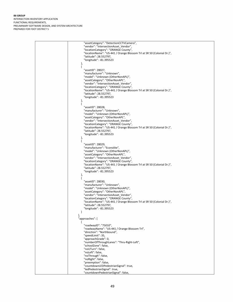
IBI GROUP INTERSECTION INVENTORY APPLICATION
FUNCTIONAL REQUIREMENTS,
PRELIMINARY SOFTWARE DESIGN, AND SYSTEM ARCHITECTURE PREPARED FOR FDOT DISTRICT 5
49
"assetCategory": "DetectionCCTVCamera", "vendor": "IntersectionAsset_Vendor", "locationCategory": "ORANGE County", "locationName": "US‐441 / Orange Blossom Trl at SR 50 (Colonial Dr.)", "latitude": 28.552797, "longitude": ‐81.395523 }, { "assetID": 28027, "manufacturer": "Unknown", "model": "Unknown (OtherNonAPL)", "assetCategory": "OtherNonAPL", "vendor": "IntersectionAsset_Vendor", "locationCategory": "ORANGE County", "locationName": "US‐441 / Orange Blossom Trl at SR 50 (Colonial Dr.)", "latitude": 28.552797, "longitude": ‐81.395523 }, { "assetID": 28028, "manufacturer": "Unknown", "model": "Unknown (OtherNonAPL)", "assetCategory": "OtherNonAPL", "vendor": "IntersectionAsset_Vendor", "locationCategory": "ORANGE County", "locationName": "US‐441 / Orange Blossom Trl at SR 50 (Colonial Dr.)", "latitude": 28.552797, "longitude": ‐81.395523 }, { "assetID": 28029, "manufacturer": "Econolite", "model": "Unknown (OtherNonAPL)", "assetCategory": "OtherNonAPL", "vendor": "IntersectionAsset_Vendor", "locationCategory": "ORANGE County", "locationName": "US‐441 / Orange Blossom Trl at SR 50 (Colonial Dr.)", "latitude": 28.552797, "longitude": ‐81.395523 }, { "assetID": 28030, "manufacturer": "Unknown", "model": "Unknown (OtherNonAPL)", "assetCategory": "OtherNonAPL", "vendor": "IntersectionAsset_Vendor", "locationCategory": "ORANGE County", "locationName": "US‐441 / Orange Blossom Trl at SR 50 (Colonial Dr.)", "latitude": 28.552797, "longitude": ‐81.395523 } ], "approaches": [ { "roadwayID": "75010", "roadwayName": "US‐441 / Orange Blossom Trl", "direction": "Northbound", "speedLimit": 35, "approachGrade": 0, "numberOfThroughLanes": "Thru‐Right‐Left", "schoolZone": false, "noUTurn": false, "noLeft": false, "noThrough": false, "noRight": false, "preemption": false, "countdownLEDPedestrianSignal": true, "ledPedestrianSignal": true, "countdownPedestrianSignal": false,

IBI GROUP INTERSECTION INVENTORY APPLICATION
FUNCTIONAL REQUIREMENTS,
PRELIMINARY SOFTWARE DESIGN, AND SYSTEM ARCHITECTURE PREPARED FOR FDOT DISTRICT 5
50
"pedestrianSignal": true, "partOfTSP": false, "lanes": [ { "laneType": "Left", "width": 12, "length": 113, "numberFromLeft": 0, "detectors": [], "signalHeads": [ { "fdotSignalID": 999999, "backplates": false, "pivotalHanger": true, "fya": false, "reflectiveBorder": false, "ledSignals": true, "sections": 3, "phase": "7" } ], "movementRestrictions": [] }, { "laneType": "Through", "width": 12, "numberFromLeft": 1, "detectors": [], "signalHeads": [ { "fdotSignalID": 999999, "backplates": false, "pivotalHanger": true, "fya": false, "reflectiveBorder": false, "ledSignals": true, "sections": 3, "phase": "4" } ], "movementRestrictions": [] }, { "laneType": "Through Right", "width": 12, "numberFromLeft": 2, "detectors": [], "signalHeads": [ { "fdotSignalID": 999999, "backplates": false, "pivotalHanger": true, "fya": false, "reflectiveBorder": false, "ledSignals": true, "sections": 3, "phase": "4" } ], "movementRestrictions": [] } ], "assets": [] }, { "roadwayID": "75010", "roadwayName": "US‐441 / Orange Blossom Trl", "direction": "Southbound", "speedLimit": 35,
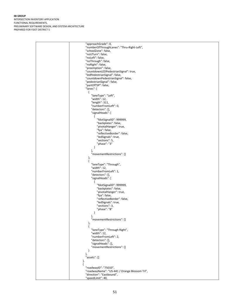
IBI GROUP INTERSECTION INVENTORY APPLICATION
FUNCTIONAL REQUIREMENTS,
PRELIMINARY SOFTWARE DESIGN, AND SYSTEM ARCHITECTURE PREPARED FOR FDOT DISTRICT 5
51
"approachGrade": 0, "numberOfThroughLanes": "Thru‐Right‐Left", "schoolZone": false, "noUTurn": false, "noLeft": false, "noThrough": false, "noRight": false, "preemption": false, "countdownLEDPedestrianSignal": true, "ledPedestrianSignal": false, "countdownPedestrianSignal": false, "pedestrianSignal": false, "partOfTSP": false, "lanes": [ { "laneType": "Left", "width": 12, "length": 311, "numberFromLeft": 0, "detectors": [], "signalHeads": [ { "fdotSignalID": 999999, "backplates": false, "pivotalHanger": true, "fya": false, "reflectiveBorder": false, "ledSignals": true, "sections": 5, "phase": "3" } ], "movementRestrictions": [] }, { "laneType": "Through", "width": 12, "numberFromLeft": 1, "detectors": [], "signalHeads": [ { "fdotSignalID": 999999, "backplates": false, "pivotalHanger": true, "fya": false, "reflectiveBorder": false, "ledSignals": true, "sections": 3, "phase": "8" } ], "movementRestrictions": [] }, { "laneType": "Through Right", "width": 12, "numberFromLeft": 2, "detectors": [], "signalHeads": [], "movementRestrictions": [] } ], "assets": [] }, { "roadwayID": "75010", "roadwayName": "US‐441 / Orange Blossom Trl", "direction": "Eastbound", "speedLimit": 40,

IBI GROUP INTERSECTION INVENTORY APPLICATION
FUNCTIONAL REQUIREMENTS,
PRELIMINARY SOFTWARE DESIGN, AND SYSTEM ARCHITECTURE PREPARED FOR FDOT DISTRICT 5
52
"approachGrade": 0, "numberOfThroughLanes": "Thru‐Right‐Left", "schoolZone": false, "noUTurn": false, "noLeft": false, "noThrough": false, "noRight": false, "preemption": true, "countdownLEDPedestrianSignal": true, "ledPedestrianSignal": true, "countdownPedestrianSignal": false, "pedestrianSignal": true, "partOfTSP": false, "lanes": [ { "laneType": "Left", "width": 12, "length": 202, "numberFromLeft": 0, "detectors": [], "signalHeads": [ { "fdotSignalID": 999999, "backplates": false, "pivotalHanger": true, "fya": false, "reflectiveBorder": false, "ledSignals": true, "sections": 5, "phase": "3" } ], "movementRestrictions": [] }, { "laneType": "Through", "width": 12, "numberFromLeft": 1, "detectors": [], "signalHeads": [ { "fdotSignalID": 999999, "backplates": false, "pivotalHanger": true, "fya": false, "reflectiveBorder": false, "ledSignals": true, "sections": 3, "phase": "6" } ], "movementRestrictions": [] }, { "laneType": "Through", "width": 12, "numberFromLeft": 2, "detectors": [], "signalHeads": [], "movementRestrictions": [] }, { "laneType": "Right", "width": 12, "numberFromLeft": 3, "detectors": [], "signalHeads": [], "movementRestrictions": [] }
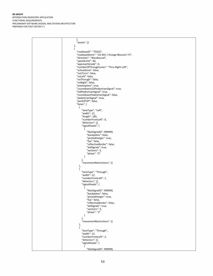
IBI GROUP INTERSECTION INVENTORY APPLICATION
FUNCTIONAL REQUIREMENTS,
PRELIMINARY SOFTWARE DESIGN, AND SYSTEM ARCHITECTURE PREPARED FOR FDOT DISTRICT 5
53
], "assets": [] }, { "roadwayID": "75010", "roadwayName": "US‐441 / Orange Blossom Trl", "direction": "Westbound", "speedLimit": 40, "approachGrade": 0, "numberOfThroughLanes": "Thru‐Right‐Left", "schoolZone": false, "noUTurn": false, "noLeft": false, "noThrough": false, "noRight": false, "preemption": true, "countdownLEDPedestrianSignal": true, "ledPedestrianSignal": true, "countdownPedestrianSignal": false, "pedestrianSignal": true, "partOfTSP": false, "lanes": [ { "laneType": "Left", "width": 12, "length": 185, "numberFromLeft": 0, "detectors": [], "signalHeads": [ { "fdotSignalID": 999999, "backplates": false, "pivotalHanger": true, "fya": false, "reflectiveBorder": false, "ledSignals": true, "sections": 3, "phase": "5" } ], "movementRestrictions": [] }, { "laneType": "Through", "width": 12, "numberFromLeft": 1, "detectors": [], "signalHeads": [ { "fdotSignalID": 999999, "backplates": false, "pivotalHanger": true, "fya": false, "reflectiveBorder": false, "ledSignals": true, "sections": 3, "phase": "2" } ], "movementRestrictions": [] }, { "laneType": "Through", "width": 12, "numberFromLeft": 2, "detectors": [], "signalHeads": [ { "fdotSignalID": 999999,

IBI GROUP INTERSECTION INVENTORY APPLICATION
FUNCTIONAL REQUIREMENTS,
PRELIMINARY SOFTWARE DESIGN, AND SYSTEM ARCHITECTURE PREPARED FOR FDOT DISTRICT 5
54
"backplates": false, "pivotalHanger": true, "fya": false, "reflectiveBorder": false, "ledSignals": true, "sections": 3, "phase": "2" } ], "movementRestrictions": [] }, { "laneType": "Right", "width": 12, "length": 116, "numberFromLeft": 3, "detectors": [], "signalHeads": [], "movementRestrictions": [] } ], "assets": [] } ], "controller": { "atmsid": 999999, "controllerType": "NEMA", "firmware": "61.4i ", "serialPort": 3, "ethernetPort": 1, "serialDropAddressNumber": "5231", "ipAddress": "10.33.217.90", "subnet": "255.255.255.192", "gateway": "10.33.217.65", "location": { "roadwayID": "75010", "roadwayName": "SR 50 (Colonial Dr.)", "section": "75010", "milepost": "14.201 ", "district": "5", "county": "ORANGE" }, "maintainingAgency": "Orlando", "assetID": 27537, "manufacturer": "Nastec", "model": "Nastec 980", "assetCategory": "Controller", "vendor": "Controller_Vendor", "locationCategory": "ORANGE County", "locationName": "US‐441 / Orange Blossom Trl at SR 50 (Colonial Dr.)", "latitude": 28.552797, "longitude": ‐81.395523 }, "cabinet": { "cabinetType": "TS2 Type 1", "cabinetSize": "Type V", "sunshields": false, "keyType": "#2‐Padlock", "ductCount": 5, "filterSize": "16\" x 12\" x 1\"", "coating": "Bare Metal", "numberOfLoadBays": 16, "transferRelays": "Unknown", "loadSwitch": "Power Distr.&Control Inc.(PDC)", "loadResistor": "Xicon 15w", "numberOfFreeDucts": 0, "numberOfDetectorCardRacks": 1, "generatorHookUp": false, "assetID": 27389,

IBI GROUP INTERSECTION INVENTORY APPLICATION
FUNCTIONAL REQUIREMENTS,
PRELIMINARY SOFTWARE DESIGN, AND SYSTEM ARCHITECTURE PREPARED FOR FDOT DISTRICT 5
55
"manufacturer": "Cabinet_Manufacturer", "model": "Cabinet_Model", "assetCategory": "Cabinet", "vendor": "Controller_Vendor", "locationCategory": "ORANGE County", "locationName": "US‐441 / Orange Blossom Trl at SR 50 (Colonial Dr.)", "latitude": 28.552797, "longitude": ‐81.395523 }, "intersectionType": "Right Angles (3 approaches)" }
Recommended