__________________________________________________________
Health Consultation __________________________________________________________
Former Zonolite Facility
Wemelco Way
Easthampton, Hampshire County, Massachusetts
EPA Facility ID: MAD019335561
DECEMBER 15, 2006
Prepared by:
Environmental Toxicology Program Center for Environmental Health
Massachusetts Department of Public Health Under a cooperative agreement with the
Agency for Toxic Substances and Disease Registry U.S. Department of Health and Human Services
Atlanta, Georgia
Foreword
ATSDR National Asbestos Exposure Review Vermiculite was mined and processed in Libby, Montana, from the early 1920s until 1990. We now know that this vermiculite, which was shipped to many locations around the United States for processing, contained asbestos. The National Asbestos Exposure Review (NAER) is a project of the Agency for Toxic Substances and Disease Registry (ATSDR). ATSDR is working with other federal, state, and local environmental and public health agencies to evaluate public health effects at sites that processed Libby vermiculite. The evaluations focus on the processing sites and on human health effects that might be associated with possible past or current exposures. They do not consider commercial or consumer use of the products from these facilities. The sites that processed Libby vermiculite will be evaluated by
1) identifying ways people could have been exposed to asbestos in the past and ways that people could be exposed now, and
2) determining whether the exposures represent a public health hazard. ATSDR will use the information gained from the site-specific investigations to recommend further public health actions as needed. Site evaluations are progressing in two phases: Phase 1: ATSDR has selected 28 sites that met either of the following criteria for the first phase of reviews:
• The U.S. Environmental Protection Agency (EPA) recommended further action at the site based upon contamination in place.
• The site was an exfoliation facility that processed more than 100,000 tons of
vermiculite ore from a Libby mine. Exfoliation, a processing method in which ore is heated and “popped,” is expected to have released more asbestos than other processing methods.
The following document is one of the site-specific health consultations that ATSDR and its state health partners are developing for each of the 28 Phase 1 sites. A future report will summarize findings at the Phase 1 sites and include recommendations for evaluating the more than 200 remaining sites nationwide that received Libby vermiculite. Phase 2: ATSDR will continue to evaluate former Libby vermiculite processing sites in accordance with the findings and recommendations contained in the summary report. ATSDR will also identify further actions as necessary to protect public health.
i
Table of Contents
Summary .....................................................................................................................................1 Introduction.................................................................................................................................3 Background.................................................................................................................................4
Statement of the Issues............................................................................................................4 History of the Former Zonolite Site........................................................................................4 Vermiculite Processing and Environmental Contamination...................................................5 Initial Site Investigation and Site Activities ...........................................................................6 Health and Environmental Concerns Associated With Asbestos ...........................................7 Asbestos Health Effects and Toxicity.....................................................................................8
Summary of Field Investigations ..............................................................................................16 Soil Sampling........................................................................................................................16 Air Monitoring ......................................................................................................................20
MDPH Site Visits .....................................................................................................................23 Exposure Pathway Analysis......................................................................................................24
Past Exposure Pathways .......................................................................................................25 Present Exposure Pathways ..................................................................................................28 Future Exposure Pathways....................................................................................................30
Discussion.................................................................................................................................31 Exposure Assessment and Toxicological Evaluation ...............................................................32
Exposure and Health Concerns Associated With the Former Zonolite Facility...................32 Health Outcome Data............................................................................................................37
Child Health Section.................................................................................................................38 Conclusions...............................................................................................................................39 Recommendations.....................................................................................................................41 Public Health Action Plan.........................................................................................................42
Past Actions ..........................................................................................................................42 Ongoing Actions ...................................................................................................................42
Certification ..............................................................................................................................45 References.................................................................................................................................46 Tables 1–9.................................................................................................................................50 Figures 1–8................................................................................................................................57 Appendices A–D.......................................................................................................................65
Appendix A...........................................................................................................................66 Appendix B ...........................................................................................................................75 Appendix C ...........................................................................................................................76 Appendix D...........................................................................................................................77
ii
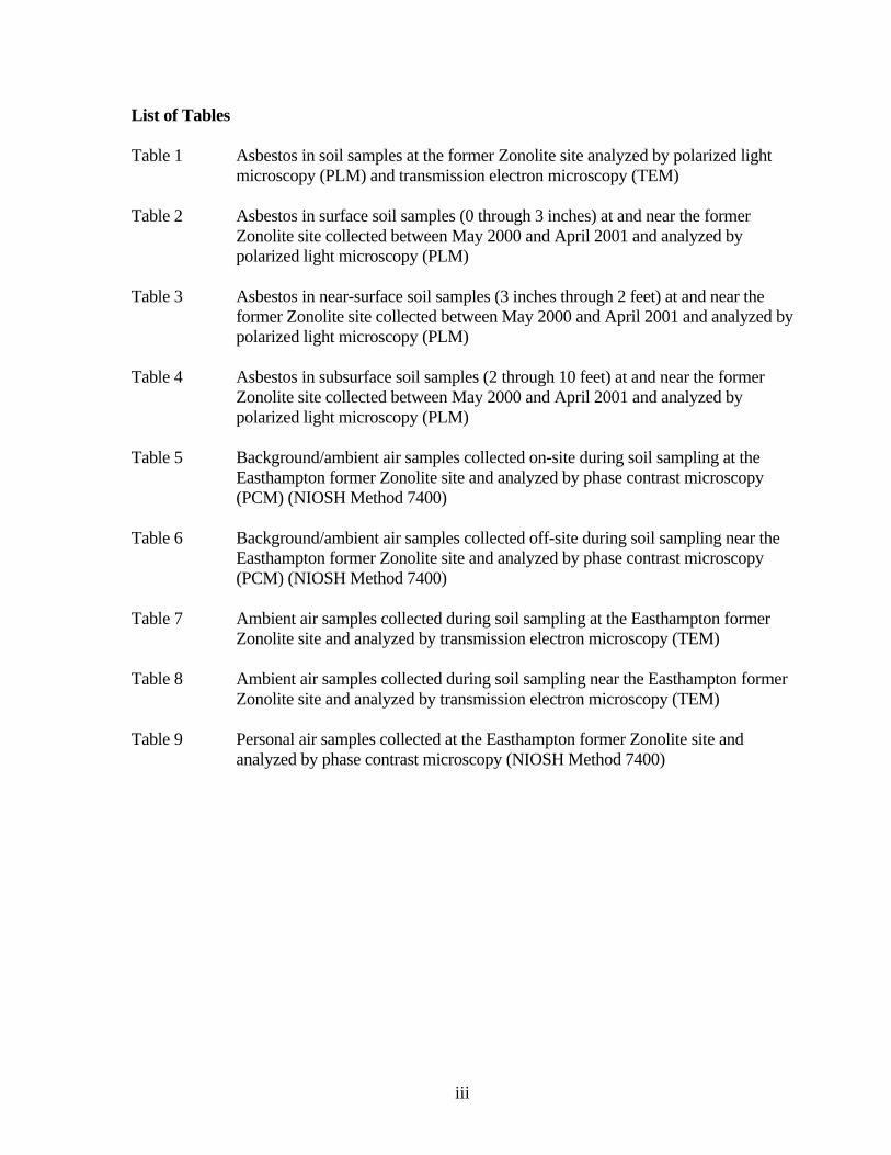
List of Tables Table 1 Asbestos in soil samples at the former Zonolite site analyzed by polarized light
microscopy (PLM) and transmission electron microscopy (TEM) Table 2 Asbestos in surface soil samples (0 through 3 inches) at and near the former
Zonolite site collected between May 2000 and April 2001 and analyzed by polarized light microscopy (PLM)
Table 3 Asbestos in near-surface soil samples (3 inches through 2 feet) at and near the
former Zonolite site collected between May 2000 and April 2001 and analyzed by polarized light microscopy (PLM)
Table 4 Asbestos in subsurface soil samples (2 through 10 feet) at and near the former
Zonolite site collected between May 2000 and April 2001 and analyzed by polarized light microscopy (PLM)
Table 5 Background/ambient air samples collected on-site during soil sampling at the
Easthampton former Zonolite site and analyzed by phase contrast microscopy (PCM) (NIOSH Method 7400)
Table 6 Background/ambient air samples collected off-site during soil sampling near the
Easthampton former Zonolite site and analyzed by phase contrast microscopy (PCM) (NIOSH Method 7400)
Table 7 Ambient air samples collected during soil sampling at the Easthampton former
Zonolite site and analyzed by transmission electron microscopy (TEM) Table 8 Ambient air samples collected during soil sampling near the Easthampton former
Zonolite site and analyzed by transmission electron microscopy (TEM) Table 9 Personal air samples collected at the Easthampton former Zonolite site and
analyzed by phase contrast microscopy (NIOSH Method 7400)
iii

List of Figures
Figure 1 Site map of the former Zonolite facility, Easthampton, Massachusetts Figure 2 Site plan with sample locations, former Zonolite facility, Wemelco Way,
Easthampton, Massachusetts Figure 3 Initial surface soil sampling in May 2000, former Zonolite facility, Wemelco
Way, Easthampton, Massachusetts Figure 4 Detection in off-site rail bed west of the facility, former Zonolite facility,
Wemelco Way, Easthampton, Massachusetts Figure 5 Asbestos surface soil detections from grid sampling, former Zonolite facility,
Wemelco Way, Easthampton, Massachusetts Figure 6 Asbestos subsurface soil detections, former Zonolite facility, Wemelco Way,
Easthampton, Massachusetts Figure 7 Easthampton personal air samples (1974 to 1984), former Zonolite facility,
Wemelco Way, Easthampton, Massachusetts Figure 8 Easthampton personal air samples (1985 to 1991), former Zonolite facility,
Wemelco Way, Easthampton, Massachusetts
iv
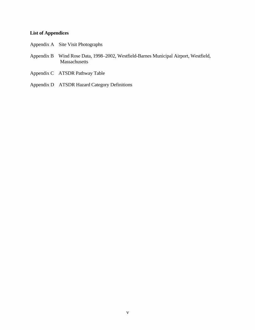
List of Appendices Appendix A Site Visit Photographs Appendix B Wind Rose Data, 1998–2002, Westfield-Barnes Municipal Airport, Westfield, Massachusetts Appendix C ATSDR Pathway Table Appendix D ATSDR Hazard Category Definitions
v
Summary
The former Zonolite facility in Easthampton, Massachusetts, was an exfoliation plant
operated by W.R. Grace & Company (WRG). The facility received asbestos-
contaminated vermiculite from Libby, Montana, from 1963 to 1984, for the production of
Zonolite attic insulation and Monokote fireproofing material. The facility continued
production using vermiculite from other sources until 1992. The site, including a former
rail line that abuts and passes through the southeastern property boundary, is located in a
mixed residential and commercial area. It is one of 28 Phase 1 sites being evaluated by
the federal Agency for Toxic Substances and Disease Registry (ATSDR) National
Asbestos Exposure Review.
ATSDR analyzed environmental data and limited historical information for the site to
assess past, present, and future opportunities for exposure for workers and the
surrounding community. From this analysis, ATSDR determined that a completed
exposure pathway of inhalation exposure to asbestos existed in the past for workers. It
also existed for people who were in contact with workers at home, and potentially for
individuals who may have had access to the site and areas of the rail bed that pass
through and extend out from the site. Under past conditions the site posed a public health
hazard. Currently, the potential pathway is still a concern with regard to certain areas of
the rail bed.
Surface soil results analyzed by polarized light microscopy (PLM) indicate that
detections of up to 9.8% asbestos were found in the on-site disposal area, which is
currently covered and surrounded by thick vegetation. The site is accessible, primarily via
an inactive rail bed that passes through and extends outward from the site. The on- and
off-property portions of this rail bed contain asbestos ranging from nondetectable
amounts up to 3.3% in surface soil. Of the sampling results available to date, the highest
rail bed concentrations are located just off the property to the west-southwest. Evidence
that the rail bed is currently used includes worn foot paths, empty beverage cans, and all-
terrain vehicle (ATV) tracks. A path from the rail bed leads to a residential area nearby.
1
Plans for construction of a bike path, part of a rails-to-trails project, have been proposed
for the rail bed. Exposure concerns must be addressed before construction can begin.
More than 50% of the surface soil samples collected along the rail bed had trace
detections of asbestos. Furthermore, recreational activities tend to disturb surface soil and
create dust. They also may increase a person’s rate of breathing, which may potentially
increase the intake of asbestos-contaminated soil or dust.
Under current site conditions, according to ATSDR criteria, ATSDR would classify the
site as an “indeterminate public health hazard.” Asbestos was detected in soil at levels at
or above (≥) 1% and trace detection less than (<) 1% along the off-property and on-
property portions of the rail bed. Evidence of ATV recreational use (e.g., possible ATV
tracks and ramps) along the rail bed suggests that exposure to asbestos in air could
potentially occur at the site. However, no air data are available for this area while
recreational activities were occurring.
Further action is recommended to improve security or reduce opportunities for exposure,
particularly along the rail bed west of Wemelco Way where recreational activities appear
to be occurring. Additional soil and air sampling are recommended, also. Given that
asbestos levels were found in air during soil boring work on the property, the
Massachusetts Department of Public Health (MDPH) recommends that air sampling be
conducted as a precaution during future remediation and development to assess
opportunities for exposure. A review of asbestos-related cancer incidence and mortality
information by MDPH is in progress and will be released as a separate report.
2
Introduction The former Zonolite facility is located at the end of Wemelco Way in Easthampton,
Massachusetts (Figures 1 and 2), in a mixed residential and commercial area. The site is
bordered by
• Wemelco Way on the west,
• D.O.S Concrete Construction Co. (DOS) to the north,
• a former rail line that runs northeast-southwest through Easthampton to the south,
and
• a hayfield to the east.
Approximately 1,393 people live within ½ mile of the site (W&C 2001a). The nearest
residences are located within a 10th of a mile from the property boundary. A preschool
operates within a ¼ mile northwest of the site.
The site occupies approximately 2.5 acres. It includes a warehouse (the location of the
former Zonolite facility), a large paved parking lot on the northwest side of the building,
and a former rail line that extends beyond the property boundary. East of the facility, an
underground natural gas line runs south to north, and east of the gas line is a hayfield (see
Figures 1 and 2 for site plan). Thick vegetation covers much of the site, but the rail bed
and possibly the disposal area are accessible. Parts of the rail bed area are exposed, but
thick plant growth covers the disposal area. There are no fences or locked gates on the
property.
Plans to construct a bike path along the rail bed have been proposed. Exposure concerns
with regard to asbestos will need to be addressed before construction.
3
Background
Statement of the Issues
The former Zonolite site in Easthampton is one of 28 Phase 1 sites being evaluated by the
Agency for Toxic Substances and Disease Registry (ATSDR) as part of the National
Asbestos Exposure Review. It was the site of an exfoliation facility that received
shipments of concentrated vermiculite from Libby, Montana, beginning in 1963.
Vermiculite ore1 from the Libby mines was contaminated with a specific form of
asbestos, referred to as Libby asbestos. W.R. Grace & Company (WRG) shipping
invoices, although not available from 1963 through 1966, indicate that from February
1966 to September 1984, approximately 183,255 tons of vermiculite from Libby were
processed at the plant in Easthampton (EPA, unpublished, undated)2.
History of the Former Zonolite Site Available records, from ATSDR and the Massachusetts Department of Environmental
Protection (MA DEP) Western Regional Office (WERO) indicate that the exfoliation
facility was operated by Grace Construction Products, a unit of WRG, and leased from
Oldon Realty Trust /Oldon Limited Partnership (Oldon) from 1963 to 1992 (Leggette,
Brashears & Graham 1996). Exfoliated vermiculite3 is commonly used as a conditioner
for potting soil. It is also used as a bulking agent or additive in paint and plaster and for
applications such as fireproofing and insulation. According to MA DEP, the Easthampton
facility processed Libby vermiculite ore until 1984 and manufactured Zonolite attic
insulation and Monokote, a spray-on fire protection for structural steel (MA DEP 2000a).
1 The term “vermiculite ore” refers to the combination of vermiculite, Libby asbestos, and rock as it was mined in Libby, Montanta. The term “vermiculite concentrate” or simply “vermiculite” is used to describe the graded vermiculite that was shipped from Libby to the various processing/handling sites. 2 Documentation was provided by W.R. Grace in response to an EPA CERCLA 104(e) request for information. 3 Once exfoliated by rapid heating, the resultant puffed vermiculite is light, stable, and resistant to heat.
4
From 1984 to 1992, the plant continued production with vermiculite from locations other
than Libby, Montana (Brian O’Connell, WR Grace, personal communication, February 2,
2003).
Vermiculite Processing and Environmental Contamination
Remedium Group Inc. (a subsidiary of WRG) hired Woodard & Curran Inc. (W&C) to
conduct environmental investigations at the Easthampton facility. W&C noted that
vermiculite concentrate was transported to the site by railway, processed and bagged
within the facility, then loaded into trucks for shipping. Detectable amounts of
asbestiform (asbestos-like) minerals were apparently present in the vermiculite
concentrate. Spillage and disposal of some vermiculite occurred on the northeastern side
of the site (W&C 2001a).
Waste materials from the plant included stoner or waste rock, vermiculite fines and
screening, and baghouse dust (MA DEP 2000a). Records indicate that material was
disposed of at the Oliver Street municipal landfill in Easthampton (operated 1963–1992)
and at the Loudville Road town dump, which operated until 1969. However, sampling
results indicate that the on-site field (approximately 200-by-300 feet in area) east of the
facility (Figures 1 and 2) was also used for disposal of byproducts from the facility
(W&C 2001a). In this report, this area is referred to as the disposal area. During the
plant’s operation, MA DEP inspected the facility from time to time and responded to
complaints from nearby residents about dust and odors from the plant (MA DEP 2000a).
Since 1997, J.P. Stevens Elastomerics (JPS)4 has leased the former Zonolite facility for
storage of plastic goods (Personal communication, Tom Vinci, president, Stevens
Roofing Systems, concerning pathway analysis and when JPS began leasing the facility.
January 27, 2003). During site investigations, W&C noted that JPS employees
infrequently visited the facility to load and unload products, and that the facility was
often unoccupied (W&C 2001b). Available information indicates that the facility was 4 JPS is the parent company of a roofing company and Steven’s Urethane (JPS 2003a).
5

unoccupied from 1992 to 1997. In 2000, when media reports about possible asbestos
contamination appeared, Tom Vinci, the vice president of JPS, contacted Oldon for more
information. The leasing company reported that before they left, WRG removed all the
manufacturing equipment and had the plant washed down (WRG 1992). In 1992, WRG
also collected five indoor air samples after the equipment was removed and the plant was
washed down (WRG 1992). In 2000, Vinci hired Con-Test Analytical Laboratories of
East Longmeadow, Massachusetts, to conduct sampling of the walls, floors, and
insulation. Seven bulk samples of these surface materials were collected at several
locations throughout the facility (JPS 2000). No indoor air samples have been collected
since 1992.
Initial Site Investigation and Site Activities
In May 2000, MA DEP and the U.S. Environmental Protection Agency (EPA) conducted
limited soil sampling at the former Zonolite facility and along the rail bed (Figure 3).
Asbestiform minerals, ranging from 5% to 10% actinolite/tremolite, were detected by
transmission electron microscopy (TEM) in soil samples from the disposal area (Table 1).
In August 2000, MA DEP issued a Notice of Responsibility/Notice of Response Actions
to WRG (W&C 2001a) and in June 2001, it classified the property as a Tier II site5. MA
DEP established June 30, 2001, as an interim deadline for reporting summary activities
and analytical results accomplished to date and to begin discussion of remedial options
for this site (W&C 2001a).
Two public information meetings were held by EPA and MA DEP. One on July 11, 2000,
provided a brief site history. One on December 12, 2000, presented results of the soil
investigations conducted in May 2000 and plans for future site assessment activities. In
preparation for the July meeting, the Massachusetts Department of Public Health (MDPH)
prepared a memo summarizing cancer incidence data from the Massachusetts Cancer Registry
5 Tier II is a designation given to certain hazardous waste sites, following criteria in Massachusetts General Law, Chapter 21E and the Massachusetts Contingency Plan (310 CMR 40.0480). Tier II sites are a lesser priority than Tier I sites in Massachusetts.
6
(MCR). It reported the incidence of mesothelioma reported among Easthampton residents from
1982 to 1995 (the latest year for which complete cancer incidence data for the state were
available at that time). The review revealed a total of one mesothelioma case among
Easthampton residents during that period. MDPH also noted that staff would be reviewing
asbestos-related cancer incidence and mortality data for Easthampton to better address
community concerns (MDPH 2000). At the December 2000 meeting, MA DEP noted that clean-
up work, if necessary, would be coordinated with plans for a sewer line and construction of the
bike path (MA DEP 2000b).
MDPH staff participated in three site visits. The first, on September 18, 2002, included
representatives from ATSDR, WRG, the Easthampton Health Department, and MA
DEP/WERO. The other site visits were conducted November 6, 2002, and September 23, 2003,
with MA DEP/WERO. The three site visits focused especially on the on- and off-site portions of
the rail bed that was used to transport Zonolite ore to and from the facility (where the proposed
bike path would be constructed) and the disposal area (see photographs in Appendix A).
Health and Environmental Concerns Associated With Asbestos
The following sections provide an overview of several concepts relevant to the evaluation of
asbestos exposure, including health effects, analytical techniques, and the current regulations
concerning asbestos in the environment. ATSDR’s upcoming summary report for the
national review of vermiculite sites will include a more detailed discussion of these topics.
Asbestos Overview Asbestos is a general name applied to a group of silicate minerals consisting of thin,
separable fibers arranged in parallel. Asbestos minerals fall into two classes, serpentine and
amphibole. Serpentine asbestos has relatively long and flexible crystalline fibers. This class
includes chrysotile, the predominant type of asbestos used commercially. Amphibole
asbestos minerals are brittle and have a rod- or needle-like shape. Amphibole minerals
regulated as asbestos by the U.S. Department of Labor’s Occupational Safety and Health
7
Administration (OSHA) include five classes: fibrous tremolite, actinolite, anthophyllite,
crocidolite, and amosite. Other amphibole minerals, including winchite, richterite, and
others, can exhibit fibrous asbestiform properties (ATSDR 2001).
Asbestos fibers do not have any detectable odor or taste. They do not dissolve in water or
evaporate, and they are resistant to heat, fire, and chemical and biological degradation.
The vermiculite mined from Zonolite Mountain is contaminated with amphibole asbestiform
fibers, including winchite, richterite, and tremolite, as defined by Leake et al. (1997; Meeker
et al. 2003). Collectively, the asbestiform minerals contaminating the vermiculite are referred
to as Libby asbestos. The raw vermiculite ore was estimated to contain up to 26% Libby
asbestos (MRI 1982). For most of the mine’s operation, Libby asbestos was considered a
byproduct of little value and was not used commercially. The mined vermiculite ore was
processed to remove unwanted materials. It was then sorted into various grades or sizes of
vermiculite that were then shipped to sites across the nation for expansion (exfoliation) or use
as a raw material in manufactured products. Samples of the various grades of unexpanded
vermiculite shipped from the Libby mine contained 0.3% through 7% fibrous tremolite-
actinolite (by mass) (MRI 1982).
Asbestos Health Effects and Toxicity
Breathing any type of asbestos increases the risk of the following health effects:
• Malignant mesothelioma – Cancer of the membrane (pleura) that surrounds the
lung and other internal organs. This cancer can spread to tissues surrounding the
lungs or other organs. Virtually all mesothelioma cases are attributable to asbestos
exposure (ATSDR 2001).
8
• Lung cancer – Cancer of the lung tissue, also known as bronchogenic carcinoma. The
exact mechanism relating asbestos exposure with lung cancer is not completely
understood. The combination of tobacco smoking and asbestos exposure greatly
increases the risk of developing lung cancer (ATSDR 2001).
• Noncancer effects – these include asbestosis, where asbestos fibers lodged in the lung
cause scarring and reduce lung function; pleural plaques, localized or diffuse areas of
thickening of the pleura (lining of the lung); pleural thickening, extensive thickening
of the pleura which may restrict breathing; pleural calcification, calcium deposition
on pleural areas thickened from chronic inflammation and scarring; and pleural
effusions, fluid buildup in the pleural space between the lungs and the chest cavity
(ATSDR 2001).
More evidence is needed to conclude whether inhaling asbestos increases the risk of
cancers at sites other than the lungs, pleura, and abdominal cavity (ATSDR 2001).
Ingestion of asbestos causes little or no risk of noncancer effects (ATSDR 2001).
However, short-term oral exposure might cause precursor lesions of colon cancer, and
long-term oral exposure might lead to an increased risk of gastrointestinal tumors
(ATSDR 2001).
ATSDR considers the inhalation route of exposure to be the most significant in the
current evaluation of sites that received Libby vermiculite. Steps to prevent exposure
from inhaling the fibers should also protect people against most exposures from
swallowing or skin contact. Scientists generally agree that asbestos toxicity is dependent
on fiber length and mineralogy. Fiber length may affect the body’s ability to clear the
fiber. Mineralogy may affect the ability of the fiber to stay in a person’s body
(biopersistence) and surface chemistry.
ATSDR, responding to concerns about asbestos fiber toxicity from the World Trade Center
disaster, held an expert panel meeting in October 2002 to review fiber size and its role in
fiber toxicity (ATSDR 2003a). The panel concluded that fiber length plays an important
9
role in toxicity. Fibers shorter than 5 micrometers (μm) were thought to be unlikely to play
a role in mesothelioma or lung cancer promotion. However, this cannot be ruled out. Fibers
less than 5 μm in length may play a role in asbestosis when exposure duration is long and
fiber concentrations are high (ATSDR 2003a).
These concepts suggest that amphibole asbestos is more toxic than chrysotile asbestos,
mainly due to differences in physical characteristics. Chrysotile is broken down and
cleared from the lung with relative ease. Amphibole is not removed as easily and builds
up to high levels in lung tissue (Churg 1993). Some researchers believe the resulting
increased duration of exposure to amphibole asbestos significantly increases the risk of
mesothelioma and, to a lesser extent, asbestosis and lung cancer (Churg 1993). However,
OSHA continues to regulate chrysotile and amphibole asbestos as one substance, as both
types increase the risk of disease (OSHA 1994). EPA’s Integrated Risk Information
System (IRIS) assessment of asbestos also treats mineralogy and fiber length as equally
potent (EPA 2005a).
Exposure to asbestos does not necessarily mean an individual will get sick. The
frequency, duration, and intensity of the exposure, along with personal risk factors (such
as smoking, history of lung disease, and genetic susceptibility) determine the actual risk
for an individual. The mineralogy and size of the asbestos fibers involved in the exposure
are also important in determining the likelihood and the nature of potential health effects.
Because of existing data gaps and limitations in scientific knowledge related to the types
of asbestos at these sites, the risk of current or future health effects for exposed
populations is difficult to put into numbers.
Scientists suspect that some types of asbestos fibers may be more likely to cause cancer
than other asbestos fibers. The effects may also differ for different sites within the body.
More definite answers require more information on fiber exposure by mineral type. Other
data indicate that differences in fiber size distribution and other process differences can
contribute at least as much to variations in risk as does the fiber type itself (EPA 2005a).
10
Counting fibers using regulatory definitions (see Current Standards and Guidelines
section) does not adequately describe the risk of health effects. Fiber size, shape, and
composition contribute collectively to risks in ways that are still being made known. For
example, shorter fibers seem more likely to lodge in the deep lung, but longer fibers
might be more likely to increase the risk of mesothelioma (ATSDR 2001, Berman and
Crump 1999). Some of the unregulated amphibole minerals, such as winchite present in
Libby asbestos, can exhibit asbestiform characteristics and contribute to risk. Fiber
diameters greater than 2-5 μm are considered to be above the upper limit of respirability
and do not contribute significantly to risk (ATSDR 2001, Berman and Crump 2003).
Current Standards, Regulations, and Recommendations for Asbestos
Asbestos includes the six regulated asbestiform minerals (i.e., chrysotile, fibrous
tremolite, actinolite, anthophyllite, crocidolite, and amosite). In industrial applications,
asbestos containing materials are commonly defined as any material with more than 1%
bulk concentration of asbestos (EPA 1989). This is not a health-based level, but instead
represents the practical detection limit of the 1970s when OSHA regulations were
created. Recent studies show that disturbing soils containing less than 1% amphibole
asbestos can suspend fibers in air at levels of potential health concern (EPA 2001a).
Friable asbestos (asbestos which is crumbly and can be broken down to suspendable
fibers) is listed as a hazardous air pollutant on EPA’s Toxic Release Inventory (EPA
2005b). Under Section 313 of the Emergency Planning and Community Right-to-Know
Act, companies that release materials containing friable asbestos at concentrations that
equal or exceed the 0.1% reporting limit must report the release (EPA 2001b).
OSHA has set a permissible exposure limit (PEL) of 0.1 fibers per cubic centimeter (f/cc)
for asbestos fibers greater than 5 μm in length and with an aspect ratio (length-to-width)
greater than 3:1, as determined by phase contrast microscopy (PCM) (OSHA 1994). This
value represents a time-weighted average (TWA) exposure level for an 8-hour work shift,
in a 40-hour workweek over a working lifetime. In addition, OSHA has defined an
excursion limit in which no worker should be exposed to more than 1 f/cc of asbestos
11
fibers, as averaged over a sampling period of 30 minutes (OSHA 1994). Historically, the
OSHA PEL has steadily decreased from an initial standard of 12 f/cc established in 1971.
The PEL levels before 1983 were determined through worker health observations. Levels
set since then are based on quantitative risk assessment. ATSDR has used the current
OSHA PEL of 0.1 f/cc as a reference point for evaluating asbestos inhalation exposure
for past workers. ATSDR does not, however, support using the PEL for evaluating
community member exposure, as the PEL is based on an unacceptable risk level for this
population (ATSDR 2001).
In response to the World Trade Center disaster in 2001 and an immediate concern about
asbestos levels in residences in the area, the U.S. Department of Health and Human
Services, EPA, and the Department of Labor formed the Environmental Assessment
Working Group. This work group included representatives from ATSDR, EPA, the
Centers for Disease Control and Prevention’s (CDC) National Center for Environmental
Health, the National Institute of Occupational Safety and Health (NIOSH), the New York
City Department of Health and Mental Hygiene, the New York State Department of
Health, OSHA, and other state, local, and private entities. The work group set a
reoccupancy level of 0.01 f/cc, as analyzed by PCM, after cleanup. It required continued
monitoring to ensure no long-term exposure to levels of 0.01 f/cc or more. It also
recommended continuous evaluation regarding trends, further identification of sources,
and actions as practical to reduce asbestos levels. The 0.01 f/cc was considered to reflect
of the upper range of background asbestos concentrations normally found in New York
City (ATSDR 2003b).
In Massachusetts, larger asbestos removal actions at educational facilities (e.g., schools)
are subject to the federal Asbestos Hazardous Emergency Response Act (AHERA) re-
occupancy criteria of 70 [fibrous] structures per millimeter squared as analyzed by TEM
(453 CMR 6.00; 40 CFR Part 763.90[i]).6 This is not a health-based standard, but is a
level that is considered to be indistinguishable from background levels.
6 Completion of response actions for asbestos removal is also confirmed via TEM when the average concentration of asbestos in five samples collected from within the affected area is not statistically
12
In 2002, another multiagency task force headed by EPA was formed to evaluate indoor
environments for the presence of contaminants that might pose long-term health risks to
local (Lower Manhattan) residents. The task force, which included staff from ATSDR,
developed a health-based benchmark for indoor air of 0.0009 f/cc, as analyzed by PCM.
This benchmark, developed to be protective under long-term exposure, is based on risk-
based criteria that include conservative exposure assumptions and the current EPA cancer
slope factor7. The 0.0009 f/cc benchmark for indoor air is primarily applicable to
airborne chrysotile fibers and may underestimate risks for amphiboles (EPA 2003).
NIOSH set a recommended exposure limit (REL) of 0.1 f/cc by PCM for asbestos fibers
greater than 5 μm in length. This REL is a TWA for up to a 10-hour workday in a 40-
hour workweek (NIOSH 2002). The American Conference of Government Industrial
Hygienists (ACGIH) has also adopted a TWA of 0.1 f/cc as its threshold limit value
(ACGIH 2000). These standards, however, are not applicable to residential buildings or
schools because it is not necessarily protective of public health in such settings with non-
worker populations (e.g., children) or longer exposure periods.
EPA has set a maximum contaminant level (MCL) for asbestos fibers in drinking water as 7
million fibers longer than 10 μm in length per liter to prevent an increased risk of developing
benign intestinal polyps (EPA 2002). In Massachusetts, this drinking water standard value is
referred to as the Massachusetts maximum contaminant level (MA DEP 2001). Currently,
ATSDR, EPA, and MA DEP do not have guidance for asbestos in soil.
Asbestos is a known human carcinogen. Historically, EPA has calculated an inhalation
unit risk for cancer (cancer slope factor) of 0.23 (f/cc)-1 of asbestos (EPA 1986). This
value estimates additive risk of lung cancer and mesothelioma using a relative risk model
significantly different from five samples collected in the same manner outside the affected area (453 CMR 6.00; 40 CFR Part 763.90[i]). 7 The cancer slope factor estimates the probability of developing cancer from exposure to a substance over a lifetime. Assumptions of continuous exposure to a constant level of airborne fibers were combined with the IRIS slope factor for chrysolite fibers (0.23), using the PCM definition of a fiber (greater than 5 µm in length and an aspect ratio of 3:1 or greater) to establish a benchmark equivalent to a 1 in 10,000 excess 70 year lifetime cancer risk. It was then adjusted for a 35-year residence dwelling time (EPA 2003), as follows: 0.23 [conc.] = 1/10,000 * 35/70, where [conc.] = 0.0009 f/cc.
13
for lung cancer and an absolute risk model for mesothelioma. This quantitative risk
model has significant limitations:
• The unit risks were based on measurements with PCM and therefore cannot be
applied directly to measurements made with other analytical techniques.
• Unit risk should not be used if the air concentration exceeds 0.04 f/cc, because
above this concentration the slope factor might differ from that stated (EPA
1986).
Perhaps the most significant limitation is that the model does not consider mineralogy,
fiber size distribution, or other physical aspects of asbestos toxicity. EPA is updating its
asbestos quantitative risk methodology, given the limitations of the current assessment
and knowledge gained since it was implemented in 1986.
Methods for Measuring Asbestos
Various analytical methods are used to evaluate asbestos content in air, soil, and other
bulk materials. Each method varies in its ability to measure fiber characteristics such as
length, width, and mineral type.
For air samples, fiber quantification is traditionally done through PCM (NIOSH Method
7400) by counting fibers greater than 5 μm and with an aspect ratio (length-to-width)
greater than 3:1. This is the standard method by which regulatory limits were developed
(ATSDR 2001). Disadvantages of this method include the inability to detect fibers
smaller than 0.25 μm in diameter and 5 μm in length or shorter, and the inability to
distinguish between asbestos and nonasbestos fibers (ATSDR 2001).
Asbestos content in soil and bulk material samples is commonly determined using PLM,
a method that uses polarized light to compare refractive indices of minerals. This method
can distinguish between asbestos and nonasbestos fibers and between different types of
asbestos. The PLM method can detect fibers with lengths greater than approximately 1
14
μm, widths greater than approximately 0.25 μm, and aspect ratios greater than 3:1.
Detection limits for PLM methods are typically 0.25% to 1% asbestos by volume
(ATSDR 2003c).
Scanning electron microscopy (SEM) and, more commonly, TEM are more sensitive
methods and can detect smaller fibers than light microscopic techniques. TEM is a
powerful tool to identify fibers too small to be resolved by light microscopy and should be
used along with this method when necessary (OSHA 1996). TEM allows the use of
electron diffraction and energy-dispersive x-ray methods, which give information on
crystal structure and elemental composition, respectively. This information can be used to
determine the elemental composition of the visualized fibers. SEM does not allow
measurement of electron diffraction patterns. One disadvantage of electron microscopic
methods is that it is difficult to determine asbestos concentrations in soils and other bulk
materials (ATSDR 2001).
For risk assessment purposes, TEM measurements are sometimes multiplied by
conversion factors to give PCM-equivalent fiber concentrations. The correlation between
PCM fiber counts and TEM mass measurements is very poor. A conversion between
TEM mass and PCM fiber count of 30 micrograms per cubic meter (μg/m3)/(f/cc) was
adopted as a conversion factor. This value is highly uncertain, however, because it
represents an average of conversions ranging from 5 to 150 (μg/m3)/(f/cc) (Personal
Communication with Jim Christiansen, US Environmental Protection Agency, November
2002). The correlation between PCM fiber counts and TEM fiber counts is also very
uncertain. No generally applicable conversion factor exists for these two measurements
(Personal Communication with Jim Christiansen, US Environmental Protection Agency,
November 2002). Generally, a combination of PCM and TEM is used to describe the
fiber population in a particular sample.
15
Summary of Field Investigations
Soil Sampling In May of 2000, MA DEP and EPA collected 12 samples: 8 surface (0 through 3 inches) and 4
near-surface samples (3 inches through 1.5 feet). Five surface samples, and four near-surface
samples were collected from the disposal area identified by previous employees of WRG (W&C
2001a), two surface samples were collected from the on-property portion of the rail bed, and one
surface sample was collected from the portion of the rail bed west of the property (Figure 3).
Duplicate samples (A and B) were collected in case additional material was needed for analysis.
However, just sample A of each pair of samples was analyzed (MA DEP 2000c). This initial
sampling involved analysis of all 12 samples by EMSL Analytical8 of Westmont, New Jersey,
using the TEM/Chatfield method. (The Eric Chatfield method is not an EPA-approved method
for soil sampling and is pending ASTM International committee approval.) Seven of those
samples were also analyzed by PLM with dispersion staining by EPA New England’s
laboratory9. Unlike all other analyses addressed in this report, for this initial sampling:
1) all 12 samples were analyzed by TEM, which can distinguish specific types of amphibole
minerals (e.g., fibrous tremolite, actinolite and anthophyllite) and is able to identify
asbestos fibers less than 0.25 µm in diameter; and
2) dispersion staining of the samples analyzed by PLM applies color to distinguish
chrysotile (serpentine) fibers and amphibole fibers: amosite, crocidolite, tremolite, and
actinolite.
Results of the PLM with dispersion staining indicated that the type of asbestos on the site is
predominantly actinolite and tremolite, ranging from no visible asbestos to 9.8%. All—except
one detection of asbestos—were from the disposal area. The one exception was from the rail bed
just west of the site and asbestos was detected at 2.2% (sample 1A, Table 1).
Following initial sampling conducted in May 2000, EPA, MA DEP, and W&C collected
an additional 147 surface soil samples from October 2000 through April 2001 (0 through 8 Environmental Monitoring Systems Laboratory (EMSL) in New Jersey is the headquarters of EPA’s regional laboratories and specializes in the analysis of asbestos by electron microscopy (EPA 2000). 9 EPA’s Laboratory was in Lexington, Massachusetts, and is now in Chelmsford, Massachusetts.
16
3 inches), which were then analyzed by PLM (10% of samples were also confirmed by
TEM). The samples were collected generally every 50 feet on a grid approximately 1,000
by 400 feet, across the former Zonolite facility property, the rail bed, and surrounding
properties (i.e., north, east and west of the site and along the rail bed, Figures 4 and 5). A
geoprobe was used to collect 29 additional near-surface (3 inches through 2 feet) and 72
subsurface (2 feet through 10 feet) samples from the former Zonolite facility property
itself, the on-property portion of the rail bed, and the off-property portion of the rail bed
west of Wemelco Way (Figures 4 and 6). These samples were analyzed by PLM (10% of
samples were also confirmed by TEM).
PLM soil data were tabulated for surface (0 through 3 inches), near surface (3 inches
through 2 feet), and subsurface (2 through 10 feet) samples (see Tables 2, 3, and 4,
respectively) and will be discussed in terms of six areas:
1) the former Zonolite property (i.e., “the property”);
2) the rail bed on the property;
3) the rail bed east of the property;
4) the rail bed west of the property;
5) the hayfield, located adjacent to the property; and
6) other nearby properties.
The property itself (with its boundaries) is noted in Figure 4. It includes the disposal area
and a parking lot north of the facility, which abuts DOS, the concrete facility. The “site”
refers to the property and areas affected by its activities (e.g., along the rail bed where ore
was loaded and unloaded). The hayfield is located adjacent to the property,
approximately 300 feet east of the facility building and about 15 feet from the nearest
residents. Soil data for the other nearby properties were collected south of the rail bed,
west of Wemelco Way, and north of the property on the DOS property. On Figure 5,
surface soil asbestos detections from the October 2000 and April 2001 sampling rounds
are noted as follows: not detected, trace detections <1%, and detections ≥1%.
17
Unless otherwise noted, 10% of soil samples were also analyzed by TEM. Table 1
tabulates all soil samples analyzed by both TEM and PLM, and solely by TEM.
Generally, for samples analyzed by both PLM and TEM, results were within the same
range, with two exceptions:
• subsurface soil sample B-119, with a detection of 4.4% by PLM and 15% by
TEM,
• near-surface sample 8A, with a detection of 9.8% by PLM and a trace detection
<1% by TEM.
Both samples were collected from the on-site disposal area. Differences between PLM
and TEM results are due in part to the fact that the TEM method has higher magnification
and greater sensitivity. That allows TEM to detect smaller fibers (i.e., below 0.25 µm),
unless there are physical interferences that interfere with the analysis (SciLab Boston in
W&C 2001a)10.
Surface Soil /Sediment
Results for the 152 total surface soil samples collected and analyzed by PLM (10% of
samples were also confirmed by TEM) between May 2000 and April 2001 are listed in
Table 2. The samples were collected in the following quantities and locations:
• 35 from the property,
• 14 from the rail bed on-property,
• 8 from the rail bed east of the property,
• 10 from the rail be west of the property,
• 30 from the hayfield, and
• 55 from other nearby properties (27 south of the rail bed, 13 west of Wemelco
Way, and 15 north near the adjacent concrete facility).
Trace detections (<1%) were found at sample locations at the west, north, and south sides
of the property (Table 2). Asbestos detections >1% in surface soil, ranging from 1.0% to
10 According to SciLab Boston reporting notes from sample reports in W&C 2001a.
18
8.1%, were found in the east disposal area, in one sample near the northern property
boundary at 2.9%, and in two samples from the rail bed west of the property at 2.2% and
3.3%.
In addition, three surface soil samples were collected and analyzed solely by TEM in
May 2000 (two on the property not including the rail bed, and one from the on-property
portion of the rail bed). One of the samples from the property not including the rail bed
had trace detections of asbestos <1% and one had no visible asbestos. The sample from
the on-property portion of the rail bed had a trace detection (<1%) of asbestos.
Five additional surface soil samples were collected approximately 15 feet from
residences11 along the eastern border of the hayfield and analyzed by PLM. One sample
was also confirmed by TEM. No visible asbestos was identified in these five samples.
MA DEP also collected three sediment samples (0 through 3 inches) from a stream that
flows under the railroad track at the eastern corner of the property (Figure 4). These
samples were analyzed solely by PLM. One sample had trace detections (<1%) of
asbestos.
Near Surface Soil
The 31 near-surface soil samples (3 inches through 2 feet) collected and analyzed by
PLM (10% of samples were also confirmed by TEM) included
• 25 samples on the property, but not on the rail bed;
• 4 near-surface samples from the on-property portion of the rail bed; and
• 2 near-surface samples from the portion of the rail bed west of the property (Table
3).
11 These five surface soil samples are not shown on Figure 3, but they were located approximately between D-115 and I-100 in Figure 3 (Personal communication, Edward Weagle, site manager, Massachusetts Department of Environmental Protection, November 9, 2003), and they are visible in Figure 4.
19
On the property outside of the rail bed, 16 of 25 near-surface samples had trace detections
(<1%) of asbestos and 4 samples, all in the disposal area, had asbestos >1% ranging from
1.1 % to 9.8%. One of the four samples collected from the rail bed on-property had trace
detections and the other three samples had no visible asbestos. For the two samples
collected from the rail bed to the west of the property, the near-surface soil sample results
indicated no visible asbestos.
In addition, two near-surface samples were collected and analyzed solely by TEM in May
2000. Both were collected on the property, and one sample had no visible asbestos and
the other sample had trace detections (<1%) of asbestos.
Subsurface Soil W&C and MA DEP collected 72 subsurface soil samples (2 through 10 feet) from soil
borings in the disposal area (70 samples) and along the on-property portion of the rail bed
(2 through 4 feet; two samples) (Table 4). These samples were analyzed by PLM (10% of
samples were also confirmed by TEM). Nearly half of the samples (35 of 72) had trace
detections (<1%) and four samples had asbestos >1%, ranging from 1.9% to 4.4%. All
detections were in the disposal area, primarily in the shallow intervals (2 through 4 feet)
of the borings. However, the maximum concentration of 4.4% (by PLM) was from a
sample (B-119) taken at a depth of 5–6 feet depth. This sample also had a TEM detection
of 15% asbestos (Table 1). In May of 2000, before the initial sampling, former employees
of WRG identified the disposal area where presumably asbestos materials were buried
over several years (W&C 2001a).
Air Monitoring
During soil investigations from September 2000 through April 2001, ambient air and
personal air samples were collected and analyzed using PCM according to NIOSH
20
740012 method. Also, approximately 10% of the ambient air samples were analyzed by
TEM. The personal air samples were obtained within the breathing zone of the
individuals who were collecting soil samples and were analyzed by PCM to determine
compliance with OSHA’s 8-hour time weighted average, PEL, and 30-minute short-term
exposure limit (STEL) for asbestos exposure. Although federal standards are based on
PCM, PCM analysis is not able to distinguish between asbestos and nonasbestos fibers.
In September and October 2000, while soil samples (both surface and borings) were
being collected, ATC Associates, Inc. collected 24 ambient air samples (12 on the
property, not including the rail bed, and 12 in the hayfield).They also collected 17
personal air samples for the workers collecting soil samples from both on the property not
including the rail bed and in the hayfield.
In another sampling round in December 2000 to April 2001, while soil borings were
being collected, W&C contracted with FLI Environmental Inc. (Dedham, Massachusetts)
to collect ambient air and personal air samples. Twenty-nine ambient air/background
samples were analyzed by PCM and five were analyzed by TEM according to on EPA’s
AHERA standards 13 by SciLab Boston Inc.,14 of Weymouth, Massachusetts. For ambient
air samples analyzed by PCM, 16 ambient air samples were collected on-property while
soil samples and borings were actively being collected, mainly in the disposal area. In
addition, five ambient air samples were collected along the rail bed to the west of the
property, four were collected west of Wemelco Way, and four were collected from the
DOS concrete facility north of the property. Ten personal air samples for the workers
conducting soil borings on the property and along the rail bed to the west of the property
were analyzed by PCM.
12 NIOSH 7400 method uses the “A” rules for counting and does not distinguish between asbestos and non- asbestos fibers. 13 EPA AHERA standards for asbestos are in the Toxic Substances Control Act. This TEM method uses 0.45-micron pore filters and is used to distinguish asbestos and nonasbestos fibers (FLI 2001) 14 SciLab Boston Inc. participates in the National Voluntary Laboratory Accreditation Program and conducted TEM analysis for samples collected by FLI Environmental, Inc.
21
The fiber concentrations detected in ambient air during active soil sample collection
ranged from <0.001 to 0.007 f/cc by PCM and from <0.0044 to <0.0051 f/cc for the 10%
of samples analyzed by TEM. Asbestos detections in ambient air occurred on-property
near the disposal area and off-property. The highest ambient air sample detections (i.e.,
0.007 f/cc and 0.004 f/cc by PCM) occurred in the hayfield east of the property while soil
sampling activity was occurring throughout the site.
It is not entirely clear why the detections in the air monitors from the hayfield in samples
collected on October 5, 2000, were slightly higher than for other areas. As noted earlier,
there were no detectable concentrations of asbestos in soil from the hayfield. The
prevailing winds during the course of the day on October 5, 2000, were very light (i.e.,
nearly no wind) out of the northeast (i.e., blowing from the hayfield toward the disposal
area) (NWS 2005). Also, the same workers who set up air sample collectors in the
hayfield were setting up their equipment throughout the site while other workers were
collecting soil samples. Hence, possible explanations for the detections found in the
ambient air samples from the hayfield might be a temporary shift in the wind direction or
perhaps cross-contamination from dust that might have been carried on the air sample
collector’s clothing from another area of the site. It is noteworthy that detectable levels of
asbestos in air outside of the property boundaries were found during these soil sampling
activities.
Personal air samples, analyzed for OSHA’s 8-hour PEL, ranged from 0.006 f/cc to 0.018
f/cc by PCM and did not exceed the 0.1 f/cc per 8-hour standard. Personal air samples
tested for OSHA’s 30-minute STEL ranged from 0.045 f/cc to 0.114 f/cc by PCM and did
not exceed 1.0 f/cc. The highest air sample levels occurred for workers who were
collecting soil borings from areas on the property, particularly near the disposal area.
According to wind direction data collected 8 miles south-southwest of the site from 1998
to 2002, the prevailing winds tend to blow from the northwest toward the southeast
(Westfield-Barnes Municipal Airport 2002), away from populated residential areas
(Appendix B).
22
MDPH Site Visits Site visits were conducted September 18, 2002; November 6, 2002; and September 23,
2003. They particularly focused on the rail bed that was used to transport vermiculite ore
to and from the facility (where the proposed bike path would be constructed) and the
disposal area (see photographs in Appendix A). Evidence of recreational activity (i.e.,
ATV tracks) along the rail bed was noted in all three site visits.
The rail bed, with rail ties, runs east and west continuously along the southern border of
the site. Some of the rail ties have become buried. Paths run on and along sections of the
rail bed on-property and both east and west of the site. These include paths with
vegetation between parallel tracks, indicating that the rail bed may currently be used for
ATV riding, walking, or biking (Appendix A, Photograph 1). The paths along the rail bed
run through areas west of the sites that contain asbestos. Other signs of ATV use in the
area were evident (e.g., other parallel tracks leading to an open field from the rail bed).
One path from the rail bed leads to a residential area (Appendix A, Photographs 2 and 3).
The nearest residences are within a 10th of a mile east of the property, beyond the
hayfield. No asbestos was detected in soil samples from the hayfield near these
residences.
During two site visits, pieces of vermiculite and asbestos in surface soil along the rail bed
were noted by MA DEP, both east and west of the facility. These observations and the
patterns of asbestos detections from previous environmental sampling, suggest that
vermiculite fell along the tracks primarily where cars were loaded and unloaded at and
near the facility (Appendix A, Photograph 4).
The disposal area is on private property, but it is not fenced, leaving it somewhat
accessible. The area is located several yards from the rail bed/bike path. It is surrounded
by vegetation and is mostly covered with high grasses, with some briars and a few trees,
primarily towards the far southeastern portion of the site (Appendix A, Photograph 5). On
a mound and inside a rusted conveyor belt in the disposal area, MA DEP noted visible
chunks of asbestos and vermiculite (Appendix A, Photographs 6–9).
23
The property itself is readily accessible; there are no fences or locked gates. Warning
signs are posted throughout the property to deter trespassing and hunting, but they make
no reference to possible contact with asbestos in soil (Appendix A, Photograph 10).
Evidence of other recreational activity (i.e., paths and dirt ramps) was observed at various
locations along the rail bed. Beverage cans and bottles were seen on both eastern and
western parts of the rail bed (Appendix A, Photographs 11–15).
A strip of land on an incline between the parking lot and the concrete company property
is covered with high grasses and debris, including pieces of concrete (Appendix A,
Photograph 16). Old cans of paint and mineral spirits were seen in a heavily vegetated
area in the northeast corner of the parking lot near the concrete company, also.
Exposure Pathway Analysis
An exposure pathway is how a person comes in contact with chemicals from a source of
contamination. Every exposure pathway consists of the following five elements:
1) a source of contamination;
2) a media, such as air or soil, through which the contaminant is transported;
3) a point of exposure where people can contact the contaminant;
4) a route of exposure by which the contaminant enters or contacts the body; and
5) a receptor population.
A pathway is considered complete if all five elements are present and connected. A
pathway is considered potentially complete if the pathway elements are (or were) likely
present, but insufficient information is available to eliminate or exclude the pathway. A
pathway may also be considered potentially complete if it is currently missing one or
more of the pathway elements, but the element(s) could easily be present at some point in
time. An incomplete pathway is missing one or more of the pathway elements and it is
likely that the elements were never present and not likely to be present at a later point in
24
time. An eliminated pathway was a potential or completed pathway in the past, but has
had one or more of the pathway elements removed to prevent present and future
exposures.
After reviewing information from Libby, Montana, and from facilities that processed
vermiculite ore from Libby, ATSDR developed a list of possible exposure pathways for
vermiculite processing facilities. All pathways have a common source—vermiculite from
Libby contaminated with Libby asbestos—and a common route of exposure—inhalation.
Although asbestos ingestion and skin exposure pathways could exist, health risks from
these pathways are minor compared to those resulting from inhalation exposure to
asbestos and will not be evaluated. Examples of the exposure pathways generally
considered for each site are listed in the table in Appendix C. Not every pathway
identified will be a significant source of exposure for a particular site. The pathways
considered specifically for Easthampton are discussed below.
Past Exposure Pathways
Occupational (In-plant) Exposure Pathways From 1964 to 1984, a completed exposure pathway existed for former workers of the
Zonolite facility. Workers may have inhaled Libby asbestos fibers in dust during plant
operations and while transporting materials on- and off-site. WRG records obtained by
ATSDR indicate that former workers were exposed to significant levels of Libby asbestos
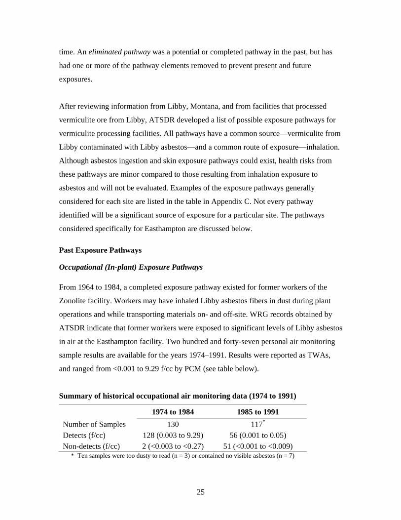
in air at the Easthampton facility. Two hundred and forty-seven personal air monitoring
sample results are available for the years 1974–1991. Results were reported as TWAs,
and ranged from <0.001 to 9.29 f/cc by PCM (see table below).
Summary of historical occupational air monitoring data (1974 to 1991)
1974 to 1984 1985 to 1991 Number of Samples 130 117*
Detects (f/cc) 128 (0.003 to 9.29) 56 (0.001 to 0.05) Non-detects (f/cc) 2 (<0.003 to <0.27) 51 (<0.001 to <0.009)
* Ten samples were too dusty to read (n = 3) or contained no visible asbestos (n = 7)
25

Of the personal air monitoring samples collected from 1974 to 1984, about 94%
(122/130) were above the current OSHA limit of 0.1 f/cc (Figure 7). Of the 117 personal
samples collected from 1985 to 1991, when the facility no longer received Libby
vermiculite, none of the samples exceeded the 0.1 fiber/cc limit (Figure 8) (ATSDR
2003d).
The OSHA PELs for occupational exposures to asbestos have been lowered over time.
When the asbestos PEL was first introduced in May 1971, it was set at 12 f/cc. It was
later amended to 5 f/cc (December 1971), 2 f/cc (July 1976), 0.2 f/cc (June 1986), and
finally to the current PEL of 0.1 f/cc (August 1994). Exceedances most frequently
occurred for samples collected from areas associated with the bagging of vermiculite
products, before the facility stopped receiving Libby vermiculite in 1984 (ATSDR
2003d). After 1984, no personal air samples exceeded current OSHA standards.
Despite the lack of exceedances for personal air monitoring samples after 1984, workers
in the facility may have continued to be exposed to residual contamination if the residuals
were disturbed and resuspended. However, the opportunities for exposure would be
expected to be lower than opportunities for exposure before 1984.
Household Exposure Pathways Past opportunities for a completed exposure pathway most likely existed before 1984 for
household contacts of former workers of the plant. Available industrial hygiene
information does not indicate that measures were taken to reduce exposure to workers’
household contacts (e.g., showering and changing clothes before going home). Therefore,
workers are likely to have transported Libby asbestos contaminated dust to their homes
on their clothing, skin, and hair. Household contacts of workers with jobs in which they
were exposed to high levels of dust are likely to have had the highest levels of exposure.
On-Property Exposure Pathways As noted previously, this consult does not include consideration for opportunities of
exposure through skin contact with soil or by swallowing because these pathways are
26
considered minor exposure pathways. However, soil particles can become airborne (e.g.,
during excavation) and thus pose inhalation concerns. Potential opportunities for
exposure to airborne Libby asbestos may have existed in the past for construction
workers during the installation of gas lines running south to north, across the property
(Figure 3). MA DEP noted that the gas lines were installed in the mid-1980s, before the
discovery of asbestos contaminated soil (MDPH 2002). The gas lines traverse the on-site
field east of the facility, where trace detections and up to 1% asbestos were noted in
surface and subsurface soils samples collected in 2000 and 2001. Thus, in the past,
construction workers may have had short-term potential opportunities for exposure to
Libby asbestos in dust from surface and subsurface soil during excavation.
The site is not fenced and MDPH found no evidence of any security measures taken to
limit access to the site. This is a particular concern regarding the disposal area where
asbestos was detected in surface soil at up to 8.1% and near-surface soil at up to 9.8% by
PLM. The on-property portion of the rail bed, where asbestos was detected at trace levels
<1%, also is not fenced. The disposal area soil, although currently thickly covered with
vegetation, may have been accessible in the past to trespassers.
Off-Property Exposure Pathways In the past, when the rail bed was active, it was probably less likely to have been used for
recreational activities. However, the potential for some recreational use or intermittent
contact by the public was possible.
No ambient air data were available before 2000, particularly from 1963 to 1984, the time
the plant processed vermiculite from Libby. However, several reports indicate that MA
DEP responded to complaints from residents about dust and odors (MA DEP 2000a).
Thus, in recognition of historical complaints about dust and odors, under past conditions a
potential pathway via ambient air may have existed off-site for individuals (e.g.,
residents). Such potential exposures, if they existed, would have likely been reduced or
eliminated after production using Libby vermiculite ceased in 1984.
27
Present Exposure Pathways
Occupational Exposure Pathways In August of 1992—after the Zonolite plant closed, the equipment was removed, and the
plant was washed down—five clearance indoor ambient air samples were taken from
inside the facility and analyzed by PCM. The sample results were detectable (i.e., ranged
from 0.0006 to 0.008 f/cc by PCM) but did not exceed the current OSHA limit of 0.1 f/cc
for daily occupational exposure (WRG 1992). The plant was vacant from 1992 to 1997.
From the fall of 1997 to the present, JPS/Stevens Urethane has leased the facility; they
began occupying it in the winter of 1997. Currently, employees are reported to be at the
facility infrequently to load and unload products. According to JPS, PLM bulk asbestos
analyses conducted in 2000 of the floors, walls, and insulation showed no evidence of
asbestos (JPS 2000). However, no air monitoring was conducted during normal working
conditions, therefore, a current potential air exposure pathway, while unlikely, cannot be
completely eliminated for JPS/Stevens Urethane workers.
On-Property Exposure Pathways Potential opportunities for exposure to asbestos in soil are possible, but not likely for
individuals on-site (e.g. trespassers). The highest detections of asbestos in surface soil
(8.1% by PLM), near-surface soil (9.8% by PLM), and subsurface soil (4.4% by PLM)
were noted in the disposal area, which is now heavily vegetated. The disposal area is
located about 50 to 100 feet east of the rail bed/bike path, through thick vegetation (e.g.,
some briars) and about 50 to 100 feet through a grassy field from the northern parking
lot. Because the disposal area is surrounded and covered by thick vegetation and briars, it
is not likely that individuals trespassing on the site today would have opportunities for
exposure to Libby asbestos from this area. Construction or remediation workers are more
likely to be in contact with Libby asbestos contaminated soil, particularly in the disposal
area. Those workers may have opportunities for exposure during excavation of surface
and subsurface soil if precautionary measures are not taken. However, under MA DEP
21e regulations, workers are more likely to be aware of asbestos contamination and, thus,
take precautionary measures during construction or remediation activities.
28
Opportunities for exposure seem unlikely for trespassers on the strip of land near the
northern parking lot that borders the concrete facility where asbestos in soil was detected
at 2.2% (by PLM). This strip of land is on an incline that is covered with high grasses and
large pieces of concrete debris. Because of the thick vegetation, it is not likely that
trespassing in this area would result in exposures. However, there is a potential for this to
happen if the amount of vegetation cover becomes less.
Disturbing soils on the rail bed could possibly lead to the release of asbestos in air. Of the
14 surface soil samples analyzed by PLM on the on-property portion of the rail bed, 10
had trace detection of asbestos at <1%, the rest had no visible asbestos. (Two of these
samples were confirmed by TEM, also.)
The area where trace detection samples were collected had evidence of possible ATV or
dirt bike use, and evidence of walkers or joggers along the rail bed. During site visits,
evidence for ATV tracks was noted along and parallel to the rail bed, with vegetation
between the tracks, indicating that the rail bed on-property may currently be used for
recreation. Because an ATV (or dirt bike) could possibly disturb soil enough to resuspend
asbestos fibers, inhalation exposure may occur while these activities are in progress, and
so there could be a completed pathway for ATV riders and dirt bikers along the on-
property portion of the rail bed. Also, beverage bottles and some cans were noted near a
path leading from the rail bed to a residential area. Although walking or even jogging are
activities that are not likely to disturb soil, if people are nearby while ATVs or dirt bikes
are being used, this is a potential exposure pathway for them.
No personal or ambient air sample data from the time that the soil sampling was done in
2000 and 2001 are available for areas where soil samples were collected along the on-
property portion of the rail bed. Regardless of air sample results, some studies have
indicated that areas of existing asbestos contamination (even trace levels) in soil may be
an intermittent source of asbestos in air during the time that the soil is being disturbed
29
(EPA 2001a). Thus, individuals using the rail bed and adjacent paths for recreation
potentially could be exposed to Libby asbestos in air from these activities on the
property.
Off-Property Exposure Pathways Opportunities for exposure exist for people using the rail bed (e.g., ATV riders, joggers,
bikers) west of the site where two detections in surface soil samples exceeded 1%. The
two samples were collected along the off-property portion of the rail bed west of
Wemelco Way (sample 1A and sample B+00 in Figure 4) and had respective asbestos
detections of 2.2% and 3.3% by PLM. There is evidence (e.g., ATV tracks, beverage
bottles) of recreational use along the rail bed west of the site. Consequently, a completed
exposure pathway likely exists intermittently for would-be ATV riders along the rail bed
since an ATV could disturb soil. This would likely be true for dirt bike riders as well.
Also, five samples collected on the off-property portion of the rail bed west of Wemelco
Way had trace detections of asbestos <1%. These data indicate that this area of the rail
bed west of Wemelco Way does appear to be contaminated with asbestos and may
potentially present opportunities for exposure to recreational users.
For other surrounding off-property areas, including the rail bed east of the property, the
hayfield, the area west of Wemelco Way, and the area south of the rail bed (where
possible ATV tracks were also spotted), most surface soil sample results (i.e., 90% of the
results) indicated no visible asbestos. Ambient air asbestos detections were also found off
site during soil sampling work. This indicates that there will remain a potential for off-
site exposure via the air pathway if soil that is contaminated with asbestos is disturbed
(e.g., during construction).
Future Exposure Pathways
In the future, unless current site conditions change, opportunities for exposure as
discussed above will remain the same. If proposed plans to construct the bike path move
forward, enhanced use of the site for recreation may invite additional opportunities for
30
exposure for some of the most susceptible populations (e.g., children). That might occur
through trespassing onto the property near the disposal area if no physical barrier (a
fence) is established between the bike path and the property, and through contact with
soil adjacent to the rail bed. Construction of a paved bike path could decrease or
eliminate opportunities for exposure in the future by preventing contact with asbestos
contaminated soil. Potential opportunities for airborne exposure will be a concern during
the construction phase of the bike path. Careful planning (e.g., environmental monitoring,
dust control practices) can help to reduce or eliminate these concerns. Recreational
opportunities for exposure may remain a concern if asbestos-contaminated soils are
present beside the bike path after it is completed. This concern can be addressed through
careful planning, as noted.
Workers may experience opportunities for exposure during future construction or other
types of site work that may bring them into contact with asbestos contaminated soils
present on the property, especially in the disposal area. This might be avoided through
informational sources, such as deed restrictions, that would maintain awareness on the
part of current and future owners of the property that asbestos contamination is present.
Such awareness would make it more likely that future opportunities for exposure during
site work (e.g., landscaping) would be reduced or eliminated through use of
precautionary measures (e.g., wetting soil, use of respiratory protection).
Discussion
The vermiculite processed at this site from 1963 to 1984 came from the mine in Libby,
Montana, known to contain asbestos. Studies conducted in the Libby community
associate adverse health effects with asbestos exposure (ATSDR 2002; Peipins et al.
2003). The findings at Libby provided the impetus for investigating this site and other
sites across the nation that received asbestos-contaminated vermiculite from the Libby
mine. It is important to recognize, however, that the asbestos exposures documented in
the Libby community are in many ways unique and are not collectively expected to be
present at other sites that processed or handled Libby vermiculite. The site investigation
31
at the former Zonolite facility in Easthampton is part of a national effort to identify and
evaluate potential asbestos exposures that may be expected at these other sites.
Exposure Assessment and Toxicological Evaluation Evaluating the health effects of exposure to Libby asbestos requires extensive knowledge
of both exposure pathways and toxicity data. The toxicological information currently
available is limited. Therefore, the exact level of health concern for different fiber sizes
and types of asbestos remains controversial. Site-specific exposure pathway information
is also limited or unavailable. For now, information is limited concerning:
• Past concentrations of Libby asbestos in air in and around the plant, which, along
with significant uncertainties and conflicts in the methods used to analyze
asbestos, makes it difficult to estimate the levels of Libby asbestos people may
have been exposed to;
• How often people came in contact with the Libby asbestos from the plant, because
the greatest exposure opportunities occurred over 20 years ago; and
• How some vermiculite materials, such as waste rock, were handled or disposed,
which makes it difficult to identify and assess both past and present potential
exposures.
Given these difficulties, the public health implications of past operations at this site are
evaluated qualitatively. Current health implications are likewise evaluated qualitatively.
Exposure and Health Concerns Associated With the Former Zonolite Facility MDPH personnel from the Center for Environmental Health, Environmental Toxicology
Program (CEH/ETP) summarized the available environmental data and exposure
pathways for the former Zonolite site in this health consultation. To evaluate possible
public health implications, estimates of opportunities for exposure to compounds must be
32
combined with what is known about the toxicity of the chemicals. EPA and OSHA have
defined soil with levels of asbestos >1% as asbestos containing material. However, this
definition is not health-based (EPA 2001a). Soil with trace levels of asbestos <1% can
still release fibers into the air at levels of potential health concern (EPA 2001a). Levels of
asbestos detected during environmental sampling represent a snapshot in time, also, and
may not be representative of levels of contaminants at other locations or times.
Investigations conducted in recent years indicate some on-site surface, near-surface, and
subsurface detections of >1% asbestos and trace detections <1%.
Two off-property soil samples on the rail bed west of Wemelco Way also had detectable
amounts of asbestos >1% (i.e., 2.2 % and 3.3%), and some trace detections of asbestos
<1%. In addition, personal air measurements for workers during the time that Libby
vermiculite was used at the plant (i.e., 1963 to 1984) indicate levels exceeding current
OSHA standards (e.g., the PEL of 0.1 f/cc by PCM). Hence, it is likely that a completed
exposure pathway existed in the past for former workers at the plant and household
contacts of workers during the time that Libby vermiculite was used. A completed
pathway also may have existed for trespassers in the past, if opportunities for exposure to
soil or dust in the disposal area existed (e.g., individuals may have had contact with the
disposal area when soil was exposed without vegetative cover). Remedial or construction
workers may have had opportunities for exposure before Libby asbestos contaminated
soil was detected in 2000. They could still be exposed if adequate safety measures are not
taken during current or future remediation or construction projects.
Former workers at the Zonolite facility had the greatest opportunities for exposures,
during the 20 years in which the plant was operational and using Libby vermiculite. A
plant profile completed in 1986 notes that the average number of employees at
Easthampton was approximately 20 and that 6 employees lived in Easthampton (WRG
1986). During this time, families of workers, particularly those with high levels of
exposures, may have been exposed to Libby asbestos fibers brought home on the
clothing, shoes, or hair of workers. Such exposures are likely to have significantly
33
decreased after 1984, when Libby vermiculite was no longer used at the facility. Thus,
historical exposure for former workers and their families is likely to have posed health
concerns for these individuals.
Opportunities for exposures to construction workers, such as those who installed gas
lines, may have occurred in recent years before 2000. These may have resulted in short
duration exposure opportunities to trace detections of asbestos <1 % and detections of
>1% asbestos in surface and subsurface soil samples. However, this was a short-term
project and results from the personal air samples collected from workers during the
2000–2001 soil sampling events did not exceed current occupational health standards.
Consequently, it is unlikely that this project work would have resulted in exposures of
health concern15.
Opportunities for exposures to construction or remedial workers after 2000 to the present
are not likely to have been at levels of health concern. It is likely that precautions were
taken by workers because of recent awareness of asbestos contamination at the site. This
would have reduced or eliminated exposure opportunities. Because the site is mostly
covered by plants, workers, trespassers, or others walking on the property would be
unlikely to contact or disturb bare soil containing asbestos and thus would not be
expected to experience opportunities for exposure to asbestos. The risk could increase if
site conditions were to change and more soil was exposed.
To protect workers at this site in the future against opportunities for exposure, a
mechanism should be put in place to alert them to the presence of asbestos in the soil
future. Otherwise, opportunities for exposure may occur to construction, landscaping,
remedial, and other workers who do not take precautionary measures, such as wearing
respiratory protection. Given the results of personal air samples for workers during the
2000–2001 sampling events, it appears unlikely that short duration activities would result
15 The highest air samples were found from workers collecting samples from the disposal area of the property where asbestos concentrations in soil were highest. These personal air sampling results were still in compliance with current occupational health standards. These standards would, however, not apply to the general population.
34
in exposures of health concern. However, it would always be prudent to avoid such risks
if possible. Asbestos is a known human carcinogen, and there are still significant
uncertainties with regard to the health effects of asbestos, as noted in earlier sections of
this health consultation. MA DEP is able to place an activities use limitation on the site
under their 21e program, if the property is planned to be used in the future and has not
been remediated (Personal Communication, Anna Symington, Massachusetts Department
of Environmental Protection, March 31, 2006).
Under current site conditions (i.e., without remediation), opportunities for exposure could
increase if activities that disturb soil (e.g., excavation and possibly some recreational
activities) occur on or around the site in areas where asbestos has been detected, and
especially where soil is bare. This is a particular concern with respect to the planned
construction of the rails-to-trails project. Without any barrier to prevent people from
crossing the site, additional opportunities for exposure are possible. However, walking
and other site activities that are not likely to disturb soil to the same degree as installation
of soil borings, dirt biking, etc., would pose less risk for exposure under current site
conditions. The area of highest soil concentrations, the disposal area, is covered with
thick vegetation and inaccessible, and there was no evidence of trespassing on and around
the disposal area. At times of the year when vegetation is sparse, there are specific
locations, such as the mound and near the rusted conveyor belt in the disposal area, where
Libby asbestos contamination is visible and somewhat accessible. It is not likely that
trespassers (e.g., deer hunters16) access this specific area. Inhalation exposures to those
persons would be very short and unlikely to cause unusual health concerns.
Opportunities for exposure to trespassers (including ATV riders, dirt bike riders, and
joggers) and visitors may also exist in other areas on and near the site. The strip of land
between the northern parking lot and the concrete company contained one soil sample
with a detection of 2.9% asbestos. However, since this area is covered with dense, high
grasses, opportunities for exposure to asbestos in this area appear unlikely.
16 State officials have seen deer nearby during the site visits, and there are signs to deter hunting on the property.
35

Of primary concern is the off-property rail bed west of Wemelco Way. Available data
indicate levels of asbestos >1% (e.g., two samples at 2.2% and 3.3% asbestos) and trace
detections <1% at that location. The on-property portion of the rail bed also contained
trace detections of asbestos <1%. The rail bed is sparsely vegetated and has areas of
exposed soil. Evidence of recreational activity, including paths for joggers, walkers, dirt
bike riders, and ATV ramps and tracks, were noted along the rail bed. Although, walking
and jogging are not likely to stir dust, riding a dirt bike or an ATV on the rail bed may
potentially kick up fugitive dusts that may contain asbestos and could present public
health concerns, particularly if these activities are frequent.
During sampling activities, asbestos was detected in ambient air in the hayfield east of
the property at up to 0.007 f/cc. Although below current occupational standards (e.g.,
OSHA PEL of 0.1 f/cc), these levels were above the health-based World Trade Center
guideline of 0.0009 f/cc by PCM and may present potential opportunities for inhalation
exposure to individuals in the hayfield.
However, even though asbestos levels in air were above the health-based World Trade
Center guideline of 0.0009 f/cc by PCM (during a period of active soil disturbance in the
areas of the site with the highest soil concentrations [i.e., the disposal area]), this
guideline is based on long-term, continuous residential exposure (i.e., 24 hours per day, 7
days per week, for 35 year). Thus opportunities for exposure to asbestos in air for
individuals off-property are not likely to be at levels that could pose health concerns,
particularly if soils are not disturbed. It is also important to note that The air
measurements were done via PCM, and since this method cannot distinguish between
asbestos fibers and nonasbestos fibers, it is unclear whether, or to what extent, asbestos
fibers were present in the air samples.
Also of concern at the Easthampton site are plans for future development of a rails-to-
trails project. Activities that disturb soil, such as excavation during construction (e.g.,
excavation along the rail bed and the removal of rail ties) could potentially be a public
health concern. That would occur if the detections of asbestos >1% and trace detections
36
of asbestos <1% on the rail bed are representative of concentrations in soil below the rail
bed, and if the rail bed is disturbed without adequate measures to prevent inhalation of
fugitive dust.
Health Outcome Data
In 2001, EPA identified five facilities in Massachusetts, including the former Zonolite
facility in Easthampton, that may have received contaminated vermiculite ore from the
Libby, Montana, mine. Under a separate cooperative agreement with ATSDR, MDPH’s
Center for Environmental Health, Community Assessment Program is conducting a
health statistics review in these five Massachusetts communities, including Easthampton.
The review will try to determine whether elevated rates of asbestos-related diseases have
occurred that could potentially be associated with asbestos exposures from the facilities.
It will assess the incidence of asbestos-related cancers during the period 1986 to 1995,
including mesothelioma, cancers of the lung and respiratory tract, and cancers of the
digestive organs. The review also includes mortality data for asbestos-related cancers and
other diseases, such as asbestosis, during the period 1979 to 1998.
37
Child Health Section
ATSDR recognizes that infants and children might be more vulnerable to exposures than
adults in communities faced with environmental contamination. Because children depend
completely on adults for risk identification and management decisions, ATSDR is
committed to evaluating their special interests at this site.
The effects of asbestos on children and adults are thought to be similar. However,
children could be especially vulnerable to asbestos exposures due to the following
factors:
• Children are more likely to disturb fiber-laden soils or dust while playing.
• Children are closer to the ground and are thus more likely to breathe contaminated
soils or dust.
• Children could be more at risk than people exposed later in life because of the
long latency period between exposure and onset of asbestos-related respiratory
disease.
The greatest opportunities for historical exposures were for children of former workers
while the plant was operating using Libby vermiculite. It is not likely that children would
have had access to the disposal area while the plant was operating. Nor is it likely that
children access the disposal area, which is located in a fairly remote, heavily vegetated
area of the site. Currently, there may be opportunities of exposures for children on and
off the property along the widely accessible rail bed. This may occur where evidence for
recreational activity has been observed and asbestos has been detected. It might also
occur in locations where trace amounts of asbestos were detected. Consequently, the site
may present a public health concern for children. However, this is less likely if such
exposures (i.e., along the rail bed) are infrequent.
38
Conclusions Evaluation of available environmental data for the Easthampton former Zonolite site
revealed the following:
1. A completed pathway existed in the past for workers and household contacts
of workers while the plant operated using Libby asbestos (until 1984). A
completed pathway may have existed in the past for trespassers in contact
with Libby asbestos in soil and dust in the disposal area before it was
overgrown by vegetation.
2. According to JPS, the current occupiers of the former Zonolite facility
building, PLM bulk asbestos analysis conducted in 2000 of the floors, walls,
and insulation showed no evidence of asbestos (JPS 2000). While no actual air
monitoring was conducted during normal working conditions, a current
potential air exposure pathway is unlikely for JPS workers, but cannot be
ruled out.
3. Some areas on-site have Libby asbestos-contaminated soil. The highest levels
and most widespread occurrence of Libby asbestos contamination were
detected in the on-property disposal area. Asbestos up to 8.1% by PLM was
detected in surface soil in this area and up to 9.8% was detected by PLM in
near surface soil. The disposal area is surrounded and covered by thick
vegetation, including some briars. Hence, opportunities for exposure in this
area under current site conditions seem unlikely. Should this area be
disturbed, further opportunities for exposure are possible to anyone who does
not take appropriate protective measures.
4. Ambient air testing and personal air monitoring were conducted on- and off-
site in 2000 and 2001 during soil sampling activities conducted as part of site
investigations. Up to 0.007 f/cc of asbestos was detected in ambient air and up
to 0.114 f/cc (30-minute) was detected in personal air samples. These indicate
39
that opportunities for exposure to asbestos fibers in air may exist during
remediation and construction activities.
5. Of particular concern are areas off the property, along the rail bed west of
Wemelco Way, where detections of asbestos >1% and trace detections <1%
were noted. The area also showed signs of current recreational use, such as
ATV tracks and ramps adjacent to and running south along the rail bed. ATV
use (or other recreational activities that disturb the soil) could potentially
resuspend fibers, leading to inhalation exposure opportunities, and hence be a
health concern. The rail bed (both off-property and on-property) and paths
next to the rail bed may present opportunities for exposure now and in the
future as they continue to be used for recreation.
ATSDR requires that one of five conclusion categories be used to summarize findings of
health consultations and health assessments:
1) Urgent Public Health Hazard
2) Public Health Hazard
3) Indeterminate Public Health Hazard
4) No Apparent Public Health Hazard
5) No Public Health Hazard (see Appendix D)
A category is selected from site-specific conditions, such as the degree of public health
hazard. The selection is based on the presence and duration of human exposure,
contaminant concentration, nature of toxic effects associated with site-related
contaminants, presence of physical hazards, and community health concerns.
Based on ATSDR criteria, ATSDR would classify the Easthampton former Zonolite site
under past site conditions as a "Public Health Hazard" due to long-term opportunities for
exposure to asbestos detected at levels that exceeded current guidelines in air for former
workers inside the plant, and likely in breathing zone air outside the plant for workers
involved in on-site soil disposal activities (e.g., in the disposal area) while Libby
vermiculite was used at the facility (i.e., 1963 to 1984).
40
Under current site conditions, the site is considered an “Indeterminate Public Health
Hazard.” Evidence of ATV recreational use suggests that opportunities for exposure exist
where asbestos was detected in soil at levels >1% and at trace detections of <1% along
the off-property and on-property portions of the rail bed. Based on ATSDR criteria, the
site could pose a “Public Health Hazard” in the future if soils are disturbed (e.g., during
excavation of soil or removal of rail ties) without adequate measures taken to prevent
exposures. Should future development of the rail bed result in a paved bike path, the
paved path should eliminate exposure opportunities to asbestos in soil in the future.
Recommendations
1. Further action should be taken by property owners and other entities, as appropriate,
to restrict access to the site, to improve security, and to reduce or eliminate
opportunities for exposure. This is needed where detections of asbestos equal or
exceed 1% and where trace detections were less than 1%, both on and off site. A
particular concern is the off-site portion of the rail bed west of Wemelco Way where
recreational activity is occurring.
2. Asbestos air monitoring by current property owners should be conducted during
normal working conditions to confirm that no indoor air exposure pathway exists for
JPS/Stevens Urethane workers, the current occupants of the former Zonolite facility.
3. Additional soil samples (for PLM and confirmatory TEM analysis) along the rail bed
should be collected by environmental regulatory agencies or other entities to further
assess the extent of contamination. These are particularly needed south of and
parallel to the rail bed where ATV paths were observed, and where pieces of
vermiculite were observed east and west of the property, especially before the
development of the rails-to-trails project.
4. Personal air samples should be collected along the rail bed/bike path during future
remediation and development (e.g., the proposed rails-to-trails project) by the parties
41
involved in any development plans in order to assess opportunities for exposure.
Dust suppression measures should also be taken during future development by the
parties involved to reduce any opportunities for exposure.
5. An informational mechanism should be identified by Current property owners or
environmental regulatory agencies to assure that awareness will be maintained on the
part of current and future owners of the property that asbestos contamination is
present and that precautionary measures need to be taken during site work (e.g.,
landscaping). With regard to the future of the property itself (e.g., the disposal area),
if it is planned to be used and remediation has not already occurred, an activities use
limitation under the MA DEP 21e program would be recommended.
Public Health Action Plan
Past Actions
1. A public information meeting was held by EPA and MA DEP on July 11, 2000, to
provide a brief site history. In preparation for this meeting, MDPH wrote a memo
for distribution at the meeting, summarizing cancer incidence data from the
Massachusetts Cancer Registry (MCR). The memo presented the incidence of
mesothelioma reported among Easthampton residents from 1982 to 1995 (the
latest year for which complete cancer incidence data for the state were available).
Ongoing Actions
1. MDPH will continue, upon request, to review environmental data generated for
the site, and provide public health interpretation and advice.
42
2. MDPH will continue to provide technical assistance to foster education and
outreach activities to raise awareness of the public regarding potential exposure to
asbestos and other environmental health-related concerns associated with this site.
3. MDPH’s Community Assessment Program Review is analyzing asbestos-related
cancer incidence and mortality and health outcome data is currently being
conducted by MDPH’s Community Assessment Program in relation to
environmental data for the Easthampton site and will be issued as a separate
report.
4. MDPH will continue to collaborate with local, state, and federal agencies,
including the National Asbestos Exposure Review, to address this public health
issue.
5. Upon request, MDPH will work with the town of Easthampton to review plans
and recommend appropriate environmental tests and/or precautions as warranted
for the bike path that is proposed for this site.
6. MDPH will write a letter to MA DEP and enclose a recommendation that if the
property itself (e.g., the disposal area) is planned to be used in the future and
remediation has not already occurred, an activities use limitation be placed on the
property under the MA DEP 21e program.
7. MDPH will work with ATSDR to evaluate possible education and outreach
activities for former workers and their families to educate them about past
exposures and potential health concerns.
43
Preparer of Health Consultation This document was prepared by the Environmental Toxicology Program, Center for Environmental Health, Massachusetts Department of Public Health. If you have any questions about this document, please contact Suzanne K. Condon, Associate Commissioner, CEH/MDPH, 7th Floor, 250 Washington Street, Boston, Massachusetts 02108.
44
Certification The health consultation for the former Zonolite facility, Wemelco Way, Easthampton, Massachusetts, was prepared by the Massachusetts Department of Health under a cooperative agreement with the federal Agency for Toxic Substances and Disease Registry (ATSDR). It is in accordance with approved methodology and procedures existing at the time the health consultation was initiated. Editorial review was completed by the Cooperative Agreement partner.
____________________________________ Technical Project Officer, Cooperative Agreement Team, Division of Health
Assessment and Consultation
The Division of Health Assessment and Consultation, ATSDR, has reviewed this health consultation and concurs with its findings.
______________________________________Cooperative Agreement Team Leader, DHAC, ATSDR
45
References 40 CFR Part 763 Asbestos, Sect. 763.90 Response Actions (i) Completion of Response Actions (2003). Available at: http://www.access.gpo.gov/nara/cfr/waisidx_03/40cfr763_03.html. 453 Code of Massachusetts Regulations, Department of Labor and Industries, 6.00: The Removal, Containment or Encapsulation of Asbestos. [ACGIH] American Conference of Government Industrial Hygienists. 2000. Threshold limit values for chemical substances and physical agents and biological exposure indices. Cincinnati, OH. [ATSDR] Agency for Toxic Substances and Disease Registry. 2001. Toxicological profile for asbestos (update). Atlanta: US Department of Health and Human Services. ATSDR. 2002. Health consultation on mortality in Libby, Montana. Atlanta: US Department of Health and Human Services. ATSDR. 2003a. Report on the Expert Panel on Health Effects of Asbestos and Synthetic Vitreous Fibers: The influence of fiber length. Atlanta: US Department of Health and Human Services. ATSDR. 2003b. World Trade Center Response Activities. Close-Out Report. September 11, 2001–April 30, 2003. Atlanta: US Department of Health and Human Services; May 16, 2003. ATSDR. 2003c. Health consultation: former Western Minerals Denver Plant; Denver, Denver County, Colorado; September 9, 2003. Atlanta: US Department of Health and Human Services. ATSDR. 2003d. Memo from Amanda Gonzalez to Rebecca Robateau, MDPH. Re: Documents of historical, occupational data for the Easthampton Facility from Robert Marriam, Remedium Group. April 9, 2003. Berman DW, Crump K. 1999. Methodology for conducting risk assessments at asbestos superfund sites. Part 2: Technical background document (interim version). Prepared for the US Environmental Protection Agency Region 9, San Francisco; February 15, 1999. Churg A. 1993. Asbestos-related disease in the workplace and the environment: controversial issues. In: Churg A, Katzenstein AA. The lung: current concepts (Monographs in pathology, no. 36). Philadelphia: Lippincott, Williams, and Wilkins. p. 54–77.
46
EPA Undated.Documentation of shipping invoices from various dates provided by WR Grace 104(e) as requested by EPA. [EPA] US Environmental Protection Agency. 1986. Airborne asbestos health assessment update. EPA/600/8-84/003F. EPA. 1989. Guidelines for conducting the AHERA TEM clearance test to determine completion of an asbestos abatement project. Washington, DC: US Environmental Protection Agency, Office of Toxic Substances, NTIS No. PB90-171778. EPA. 2000. Letter from Gilberto Irizarry, on-scene coordinator, to Stephen S. Ball, MA DEP/WERO. Re: Lab results from New England Regional Lab (NERL) and START-EMSL Analytical. June 12, 2000. EPA. 2001a. Memorandum from Christopher P. Weis, senior toxicologist, Libby asbestos site to Paul Peronard, on-scene coordinator, Libby asbestos site. Re: Amphibole mineral fibers in source materials in residential and commercial areas of Libby pose an imminent and substantial endangerment to public health. December 20, 2001. EPA. 2001b. The Emergency Planning and Community Right-to-Know Act. Section 313 Release and Other Waste Management Reporting Requirements. EPA 260/K-01-001. Office of Environmental Information. EPA. 2002. National primary drinking water regulations. Accessed July 16, 2002, at: http://www.epa.gov/safewater/mcl.html. EPA. 2003. World Trade Center indoor environment assessment: selecting contaminants of potential concern and setting health-based benchmarks. New York: Environmental Protection Agency Region 2. EPA. 2005a. Integrated Risk Information System (for asbestos). Accessed May 24, 2005, at: http://www.epa.gov/iris/subst/0371.htm. EPA. 2005b. Toxic Air Pollutants Web site. Accessed May 27, 2005, at: http://www.epa.gov/air/toxicair/newtoxics.html. [FLI] FLI Environmental Inc. 2001. Memo from Paul Matuszko, senior project manager, FLI Environmental Inc. to Chris Miller, Woodard & Curran. Re: Background air monitoring at the former Zonolite facility, Easthampton, MA (Project No. 2K-693), January 19, 2001. [JPS] JP Stevens Elastomerics. 2000. Memorandum from Tom Vinci, vice president, manufacturing, JPS Elastomerics to Holyoke and Hampshire plant employees. Re: Cleanup of Hampshire plant storage facility. March 9, 2000.
47
Leggette, Brashears & Graham, Inc. 1996. Oldon Limited Partnership former Grace Construction Products, Easthampton, MA. Environmental site assessment-sale. Prepared for Oldon Limited Partnership by Leggette, Brashears & Graham, Inc. Nashua, New Hampshire. [MA DEP] Massachusetts Department of Environmental Protection. 2000a. Letter from Alan Weinburg to Dennis LaCourse, Easthampton Board of Health. Re: Libby ore, disposal, residents’ complaints of dust and odors and future inspection and sampling. March 3, 2000. MA DEP. 2000b Notes on file. Re: Public information meeting. July 11, 2000. MA DEP. 2000c. Letter from Stephen Ball to Alan Weinburg. Re: Sampling in Easthampton at the former Zonolite plant. May 11, 2000. MA DEP. 2001. Standards and Guidelines for Chemicals in Massachusetts Drinking Waters (Spring 2001). Accessed January 23, 2003, at: http://www.state.ma.us/dep/brp/dws/standard.htm. Meeker GP, Bern AM, Brownfield IK, Lowers HA, Sutley SJ, Hoefen TM, et al. 2003. The composition and morphology of amphiboles from the Rainy Creek complex, near Libby, Montana. American Mineralogist 88:1955–69. Leake BE, Woolley AR, Arps DES, Birch WD, Gilbert MC, Grice JD, et al. 1997. Nomenclature of the amphiboles: report of the subcommittee on amphiboles of the International Mineralogical Association, Commission on New Minerals and Mineral Names. American Mineralogist 1997; 82:1019–37. [MDPH] Massachusetts Department of Public Health. 2000. Memorandum from Martha Steele to Charlie Kaniecki, Western Regional Office, MDPH. Re: Easthampton and cancer incidence. July 11, 2000. MDPH 2002. Memo from Rebecca Robateau to Elaine Krueger. Re: Site visit to former vermiculite exfoliation facility in Easthampton. November 6, 2002. [MRI] Midwest Research Institute. 1982. Collection, analysis, and characterization of vermiculite samples for fiber content and asbestos contamination. Report prepared for the US Environmental Protection Agency Office of Pesticides and Toxic Substances. Kansas City. September 1982. [NIOSH] National Institute of Occupational Safety and Health. 2002. Online NIOSH pocket guide to chemical hazards. Accessed July 16, 2002 at: http://www.cdc.gov/niosh/npg/npgd0000.html.
48
49
[NWS] National Weather Service. 2005. Taunton, MA—daily climate data for Westfield (BAF) for October 2000.Accessed on July 14, 2005 at: http://www.erh.noaa.gov/box/dailystns.shtml. [OSHA] Occupational Safety and Health Administration. 1994. Preamble to final rules for asbestos (amended 1994). III. Summary and explanation of revised standards. Accessed on July 16, 2002 at: http://www.osha.gov/pls/oshaweb/owadisp.show_document?p_table%20=PREAMBLES&p_id=777. OSHA. 1996. Asbestos standards 29 CFR 1910.1001, Appendix B, Detailed procedures for asbestos sampling and analysis—non-mandatory. 51 FR 22733, June 20, 1986, as amended in 61 FR 43454, August 23, 1996. Accessed November 13, 2003 at: http://www.osha.gov/pls/oshaweb/owadisp.show_document?p_table=STANDARDS&p_id=10005. Peipins LA, Lewin M, Campolucci S, Lybarger JA, Miller A, Middleton D, et al. 2003. Radiographic abnormalities and exposure to asbestos-contaminated vermiculite in the community of Libby, Montana, USA. Environ Health Perspect 111(14)1753–9. Westfield-Barnes Municipal Airport. 2002. Re: Wind rose data collected 1998 to 2002, 8 miles south-southwest of former Zonolite site in Easthampton. [W&C] Woodard & Curran Environmental Services. 2001a. Phase I initial site investigation report, W.R. Grace & Co.–Conn. Wemelco Way, Easthampton, MA. Woodard & Curran Inc. Environmental Services. Dedham, Massachusetts. June, 2001. W&C. 2001b. Field investigation work plan: former Zonolite facility, Wemelco Way, Easthampton, MA. Woodard & Curran Environmental Services. Dedham, Massachusetts. December, 2001. [WRG] WR Grace & Company. 1986. Memo from JW Wolter to JE Daniel (Enoree) and WJ McCaig, (Libby), expanding polystyrene plant managers. Re: Plant environmental profile. May 1, 1986. WRG. 1992. Clearance sampling results from WR Grace requested August 20, 1992.

50
Tables 1–9
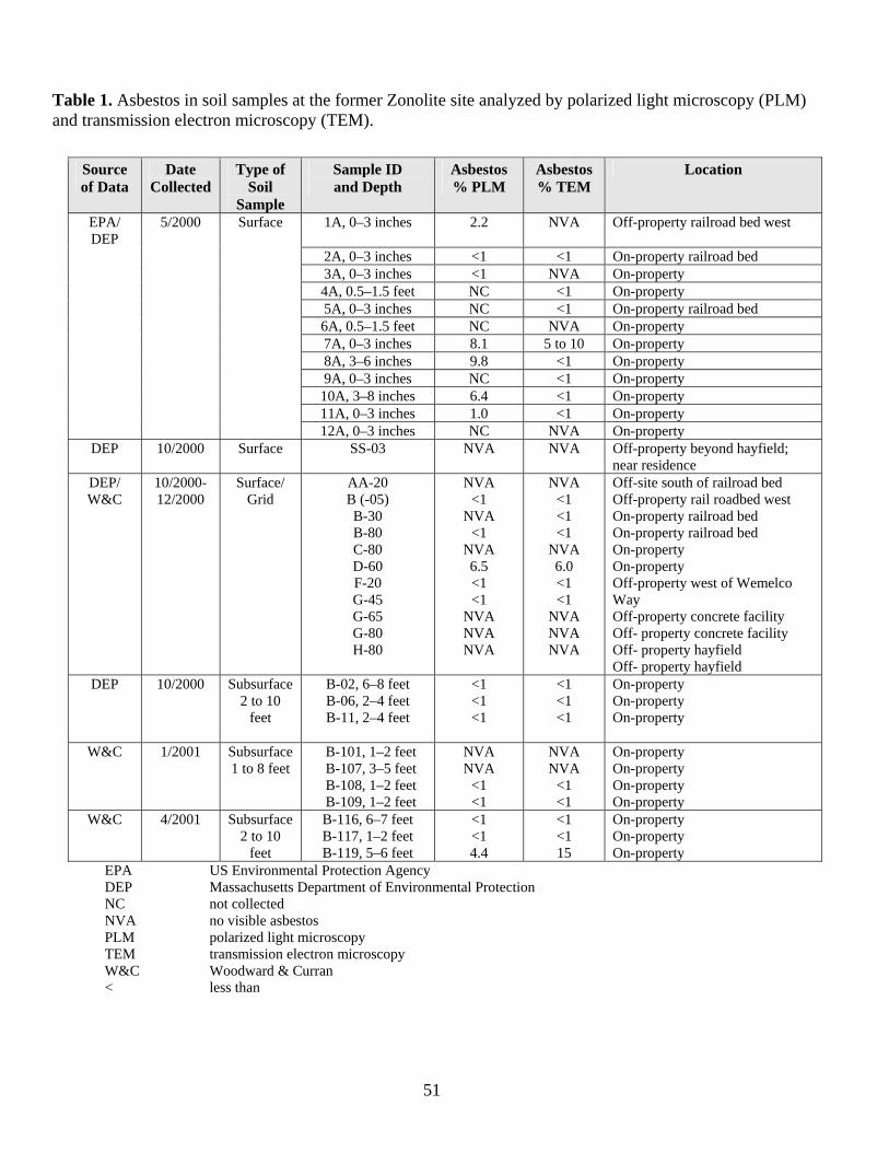
Table 1. Asbestos in soil samples at the former Zonolite site analyzed by polarized light microscopy (PLM) and transmission electron microscopy (TEM).
Source of Data
Date Collected
Type of Soil
Sample
Sample ID and Depth
Asbestos % PLM
Asbestos % TEM
Location
EPA/ DEP
5/2000 Surface 1A, 0–3 inches 2.2 NVA Off-property railroad bed west
2A, 0–3 inches <1 <1 On-property railroad bed 3A, 0–3 inches <1 NVA On-property 4A, 0.5–1.5 feet NC <1 On-property 5A, 0–3 inches NC <1 On-property railroad bed 6A, 0.5–1.5 feet NC NVA On-property 7A, 0–3 inches 8.1 5 to 10 On-property 8A, 3–6 inches 9.8 <1 On-property 9A, 0–3 inches NC <1 On-property 10A, 3–8 inches 6.4 <1 On-property 11A, 0–3 inches 1.0 <1 On-property 12A, 0–3 inches NC NVA On-property
DEP 10/2000 Surface SS-03 NVA NVA Off-property beyond hayfield; near residence
DEP/ W&C
10/2000- 12/2000
Surface/ Grid
AA-20 B (-05) B-30 B-80 C-80 D-60 F-20 G-45 G-65 G-80 H-80
NVA <1
NVA <1
NVA 6.5 <1 <1
NVA NVA NVA
NVA <1 <1 <1
NVA 6.0 <1 <1
NVA NVA NVA
Off-site south of railroad bed Off-property rail roadbed west On-property railroad bed On-property railroad bed On-property On-property Off-property west of Wemelco Way Off-property concrete facility Off- property concrete facility Off- property hayfield Off- property hayfield
DEP 10/2000 Subsurface 2 to 10
feet
B-02, 6–8 feet B-06, 2–4 feet B-11, 2–4 feet
<1 <1 <1
<1 <1 <1
On-property On-property On-property
W&C 1/2001 Subsurface 1 to 8 feet
B-101, 1–2 feet B-107, 3–5 feet B-108, 1–2 feet
NVA NVA
<1 <1
NVA NVA
<1 <1
On-property On-property On-property
B-109, 1–2 feet
51
EPA US Environmental Protection Agency
On-property W&C 4/2001 Subsurface
2 to 10 feet
B-116, 6–7 feet B-117, 1–2 feet B-119, 5–6 feet
<1 <1 4.4
<1 <1 15
On-property On-property On-property
DEP Massachusetts Department of Environmental Protection NC not collected NVA no visible asbestos PLM polarized light microscopy TEM transmission electron microscopy W&C Woodward & Curran < less than
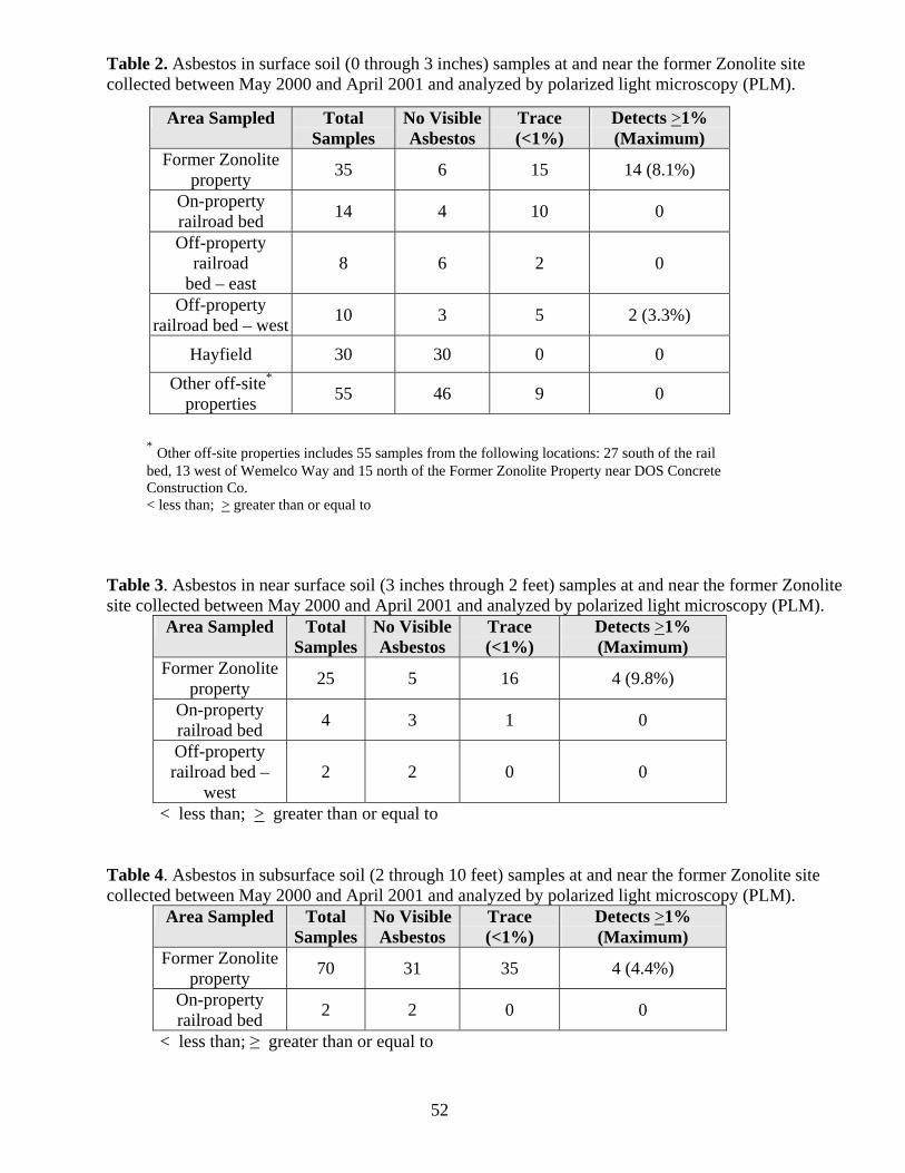
Table 2. Asbestos in surface soil (0 through 3 inches) samples at and near the former Zonolite site collected between May 2000 and April 2001 and analyzed by polarized light microscopy (PLM).
Area Sampled Total
Samples No Visible Asbestos
Trace (<1%)
Detects >1% (Maximum)
Former Zonolite property 35 6 15 14 (8.1%)
On-property railroad bed 14 4 10 0
Off-property railroad
bed – east 8 6 2 0
Off-property railroad bed – west 10 3 5 2 (3.3%)
Hayfield 30 30 0 0 Other off-site*
properties 55 46 9 0
* Other off-site properties includes 55 samples from the following locations: 27 south of the rail bed, 13 west of Wemelco Way and 15 north of the Former Zonolite Property near DOS Concrete Construction Co. < less than; > greater than or equal to
Table 3. Asbestos in near surface soil (3 inches through 2 feet) samples at and near the former Zonolite site collected between May 2000 and April 2001 and analyzed by polarized light microscopy (PLM).
Area Sampled Total Samples
No Visible Asbestos
Trace (<1%)
Detects >1% (Maximum)
Former Zonolite property 25 5 16 4 (9.8%)
On-property railroad bed 4 3 1 0
Off-property railroad bed –
west 2 2 0 0
< less than; > greater than or equal to
Table 4. Asbestos in subsurface soil (2 through 10 feet) samples at and near the former Zonolite site collected between May 2000 and April 2001 and analyzed by polarized light microscopy (PLM).
Area Sampled Total Samples
No Visible Asbestos
Trace (<1%)
Detects >1% (Maximum)
Former Zonolite property 70 31 35 4 (4.4%)
On-property railroad bed 2 2 0 0
< less than; ≥ greater than or equal to
52
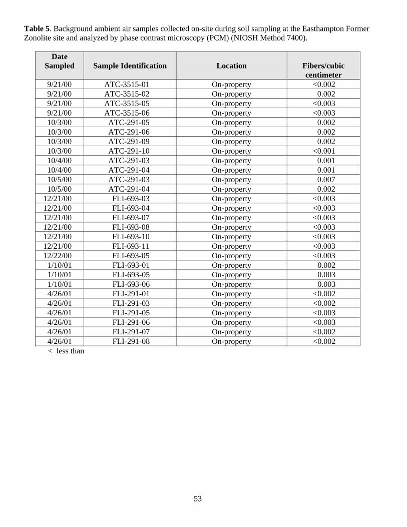
53
Table 5. Background ambient air samples collected on-site during soil sampling at the Easthampton Former Zonolite site and analyzed by phase contrast microscopy (PCM) (NIOSH Method 7400).
Date Sampled
Sample Identification
Location
Fibers/cubic centimeter
9/21/00 ATC-3515-01 On-property <0.002 9/21/00 ATC-3515-02 On-property 0.002 9/21/00 ATC-3515-05 On-property <0.003 9/21/00 ATC-3515-06 On-property <0.003 10/3/00 ATC-291-05 On-property 0.002 10/3/00 ATC-291-06 On-property 0.002 10/3/00 ATC-291-09 On-property 0.002 10/3/00 ATC-291-10 On-property <0.001 10/4/00 ATC-291-03 On-property 0.001 10/4/00 ATC-291-04 On-property 0.001 10/5/00 ATC-291-03 On-property 0.007 10/5/00 ATC-291-04 On-property 0.002
12/21/00 FLI-693-03 On-property <0.003 12/21/00 FLI-693-04 On-property <0.003 12/21/00 FLI-693-07 On-property <0.003 12/21/00 FLI-693-08 On-property <0.003 12/21/00 FLI-693-10 On-property <0.003 12/21/00 FLI-693-11 On-property <0.003 12/22/00 FLI-693-05 On-property <0.003
1/10/01 FLI-693-01 On-property 0.002 1/10/01 FLI-693-05 On-property 0.003 1/10/01 FLI-693-06 On-property 0.003 4/26/01 FLI-291-01 On-property <0.002 4/26/01 FLI-291-03 On-property <0.002 4/26/01 FLI-291-05 On-property <0.003 4/26/01 FLI-291-06 On-property <0.003 4/26/01 FLI-291-07 On-property <0.002 4/26/01 FLI-291-08 On-property <0.002
< less than
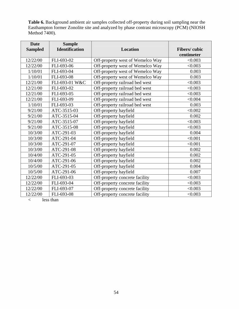
54
Table 6. Background ambient air samples collected off-property during soil sampling near the Easthampton former Zonolite site and analyzed by phase contrast microscopy (PCM) (NIOSH Method 7400).
Date
Sampled Sample
Identification
Location
Fibers/ cubic centimeter
12/22/00 FLI-693-02 Off-property west of Wemelco Way <0.003 12/22/00 FLI-693-06 Off-property west of Wemelco Way <0.003
1/10/01 FLI-693-04 Off-property west of Wemelco Way 0.003 1/10/01 FLI-693-08 Off-property west of Wemelco Way 0.003
12/21/00 FLI-693-01 W&C Off-property railroad bed west <0.003 12/21/00 FLI-693-02 Off-property railroad bed west <0.003 12/21/00 FLI-693-05 Off-property railroad bed west <0.003 12/21/00 FLI-693-09 Off-property railroad bed west <0.004
1/10/01 FLI-693-03 Off-property railroad bed west 0.003 9/21/00 ATC-3515-03 Off-property hayfield <0.002 9/21/00 ATC-3515-04 Off-property hayfield 0.002 9/21/00 ATC-3515-07 Off-property hayfield <0.003 9/21/00 ATC-3515-08 Off-property hayfield <0.003 10/3/00 ATC-291-03 Off-property hayfield 0.004 10/3/00 ATC-291-04 Off-property hayfield <0.001 10/3/00 ATC-291-07 Off-property hayfield <0.001 10/3/00 ATC-291-08 Off-property hayfield 0.002 10/4/00 ATC-291-05 Off-property hayfield 0.002 10/4/00 ATC-291-06 Off-property hayfield 0.002 10/5/00 ATC-291-05 Off-property hayfield 0.004 10/5/00 ATC-291-06 Off-property hayfield 0.007
12/22/00 FLI-693-03 Off-property concrete facility <0.003 12/22/00 FLI-693-04 Off-property concrete facility <0.003 12/22/00 FLI-693-07 Off-property concrete facility <0.003 12/22/00 FLI-693-08 Off-property concrete facility <0.003
< less than
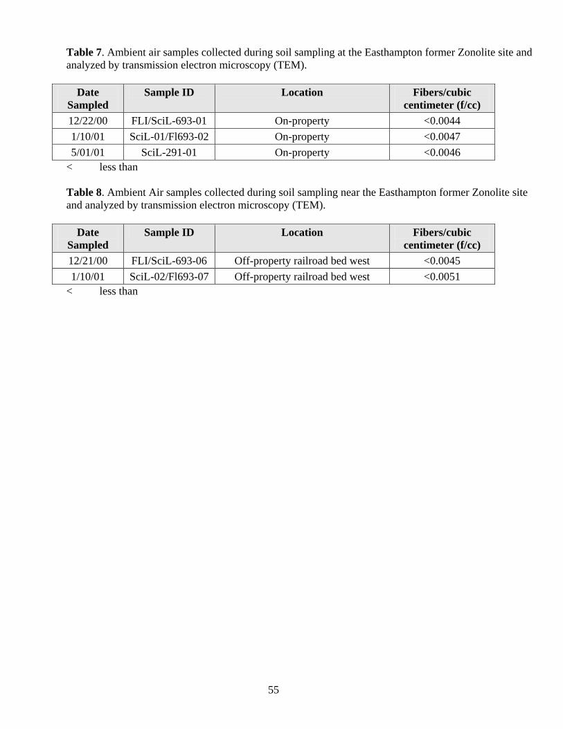
Table 7. Ambient air samples collected during soil sampling at the Easthampton former Zonolite site and analyzed by transmission electron microscopy (TEM).
Date Sampled
Sample ID Location Fibers/cubic centimeter (f/cc)
12/22/00 FLI/SciL-693-01 On-property <0.0044 1/10/01 SciL-01/Fl693-02 On-property <0.0047 5/01/01 SciL-291-01 On-property <0.0046
< less than
Table 8. Ambient Air samples collected during soil sampling near the Easthampton former Zonolite site and analyzed by transmission electron microscopy (TEM).
Date
Sampled Sample ID Location Fibers/cubic
centimeter (f/cc) 12/21/00 FLI/SciL-693-06 Off-property railroad bed west <0.0045 1/10/01 SciL-02/Fl693-07 Off-property railroad bed west <0.0051
< less than
55
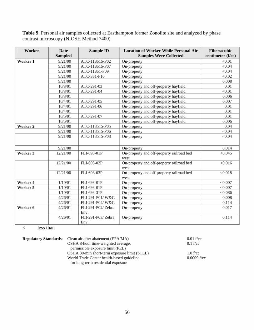
Table 9. Personal air samples collected at Easthampton former Zonolite site and analyzed by phase contrast microscopy (NIOSH Method 7400) Worker Date
Sampled Sample ID Location of Worker While Personal Air
Samples Were Collected Fibers/cubic
centimeter (f/cc) Worker 1 9/21/00 ATC-113515-P02 On-property <0.01 9/21/00 ATC-113515-P07 On-property <0.04 9/21/00 ATC-11351-P09 On-property <0.04 9/21/00 ATC-351-P10 On-property <0.02 9/21/00 On-property 0.008 10/3/01 ATC-291-03 On-property and off-property hayfield 0.01 10/3/01 ATC-291-04 On-property and off-property hayfield <0.01 10/3/01 On-property and off-property hayfield 0.006 10/4/01 ATC-291-05 On-property and off-property hayfield 0.007 10/4/01 ATC-291-06 On-property and off-property hayfield 0.01 10/4/01 On-property and off-property hayfield 0.01 10/5/01 ATC-291-07 On-property and off-property hayfield 0.01 10/5/01 On-property and off-property hayfield 0.006 Worker 2 9/21/00 ATC-113515-P05 On-property 0.04 9/21/00 ATC-113515-P06 On-property <0.04 9/21/00 ATC-113515-P08 On-property <0.04
9/21/00 On-property 0.014 Worker 3 12/21/00 FLI-693-01P On-property and off-property railroad bed
west <0.045
12/21/00 FLI-693-02P On-property and off-property railroad bed west
<0.016
12/21/00 FLI-693-03P On-property and off-property railroad bed west
<0.018
Worker 4 1/10/01 FLI-693-01P On-property <0.007 Worker 5 1/10/01 FLI-693-01P On-property <0.007 1/10/01 FLI-693-31P On-property <0.086 4/26/01 FLI-291-P01/ W&C On-property 0.008 4/26/01 FLI-291-P04/ W&C On-property 0.114 Worker 6 4/26/01 FLI-291-P02/ Zebra
Env. On-property 0.017
4/26/01 FLI-291-P03/ Zebra Env.
On-property 0.114
< less than
Regulatory Standards: Clean air after abatement (EPA/MA) 0.01 f/cc OSHA 8-hour time-weighted average, 0.1 f/cc permissible exposure limit (PEL) OSHA 30-min short-term exposure limit (STEL) 1.0 f/cc World Trade Center health-based guideline 0.0009 f/cc
for long-term residential exposure
56

57
Figures 1–8
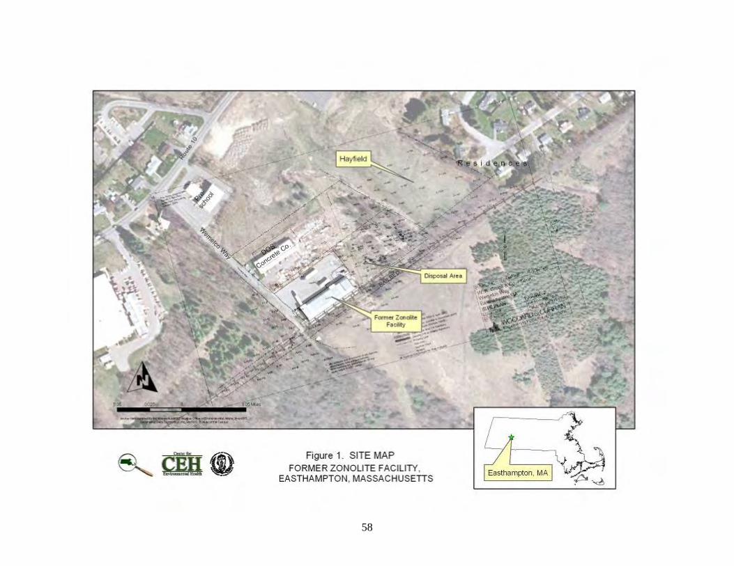
58
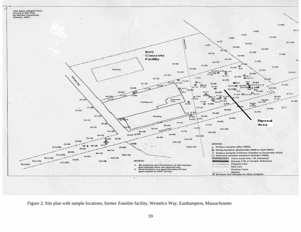
Figure 2. Site plan with sample locations, former Zonolite facility, Wemelco Way, Easthampton, Massachusetts
59
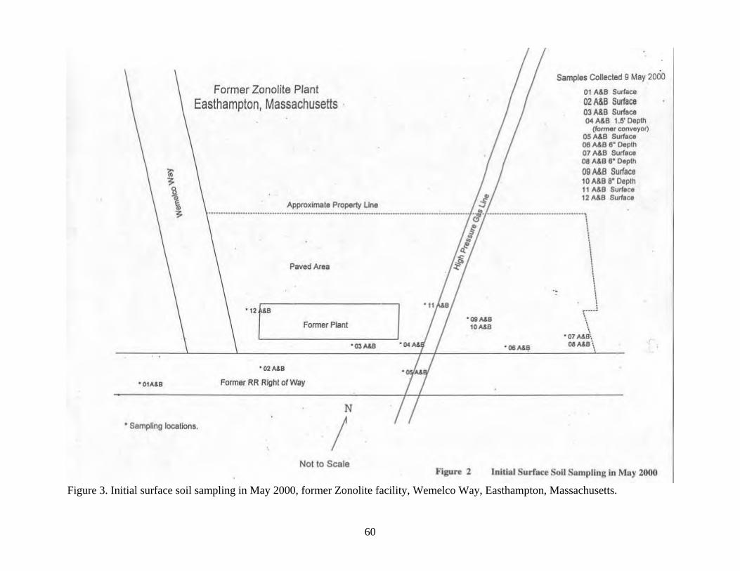
Figure 3. Initial surface soil sampling in May 2000, former Zonolite facility, Wemelco Way, Easthampton, Massachusetts.
60
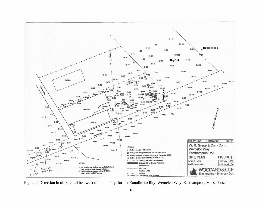
Figure 4. Detection in off-site rail bed west of the facility, former Zonolite facility, Wemelco Way, Easthampton, Massachusetts
61
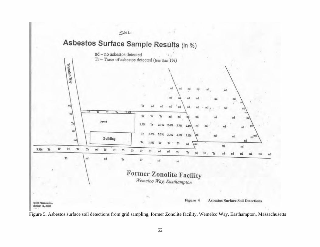
Figure 5. Asbestos surface soil detections from grid sampling, former Zonolite facility, Wemelco Way, Easthampton, Massachusetts
62
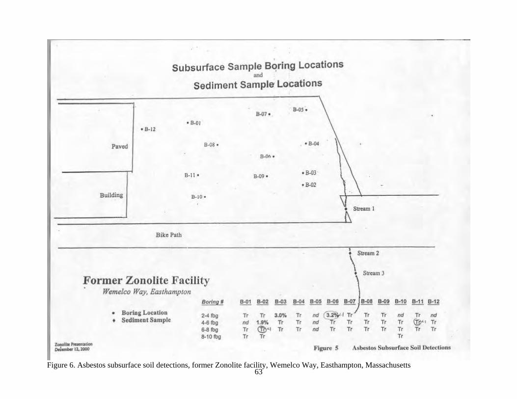
63 Figure 6. Asbestos subsurface soil detections, former Zonolite facility, Wemelco Way, Easthampton, Massachusetts
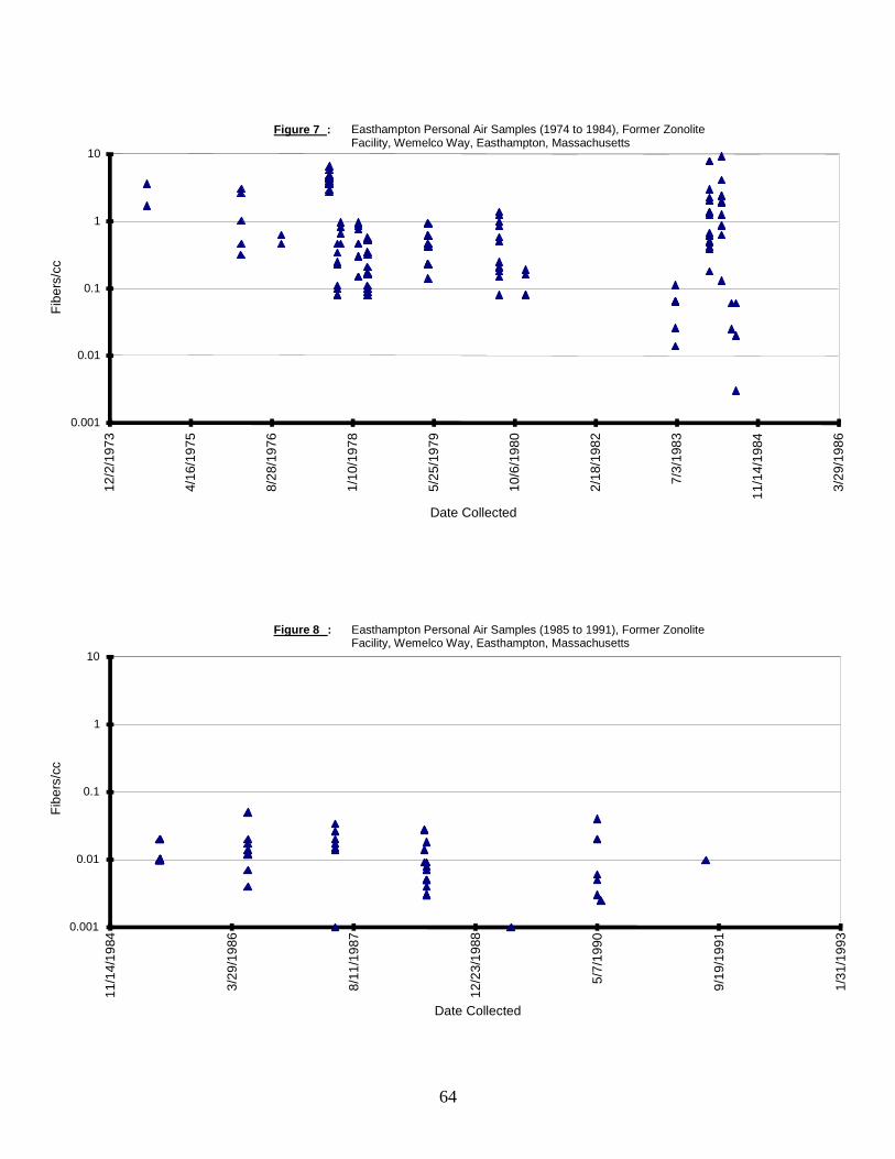
Figure 7 : Easthampton Personal Air Samples (1974 to 1984), Former Zonolite
Facility, Wemelco Way, Easthampton, Massachusetts
0.001
0.01
0.1
1
10
12/2
/197
3
4/16
/197
5
8/28
/197
6
1/10
/197
8
5/25
/197
9
10/6
/198
0
2/18
/198
2
7/3/
1983
11/1
4/19
84
3/29
/198
6
Date Collected
Fibe
rs/c
c
Figure 8 : Easthampton Personal Air Samples (1985 to 1991), Former Zonolite Facility, Wemelco Way, Easthampton, Massachusetts
0.001
0.01
0.1
1
10
11/1
4/19
84
3/29
/198
6
8/11
/198
7
12/2
3/19
88
5/7/
1990
9/19
/199
1
1/31
/199
3
Fibe
rs/c
c
Date Collected
64

Appendices A–D
65
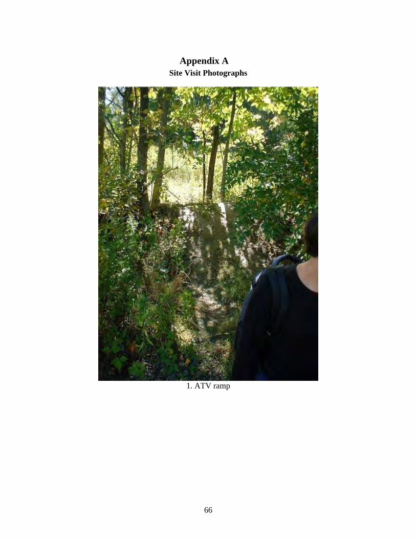
Appendix A Site Visit Photographs
1. ATV ramp
66
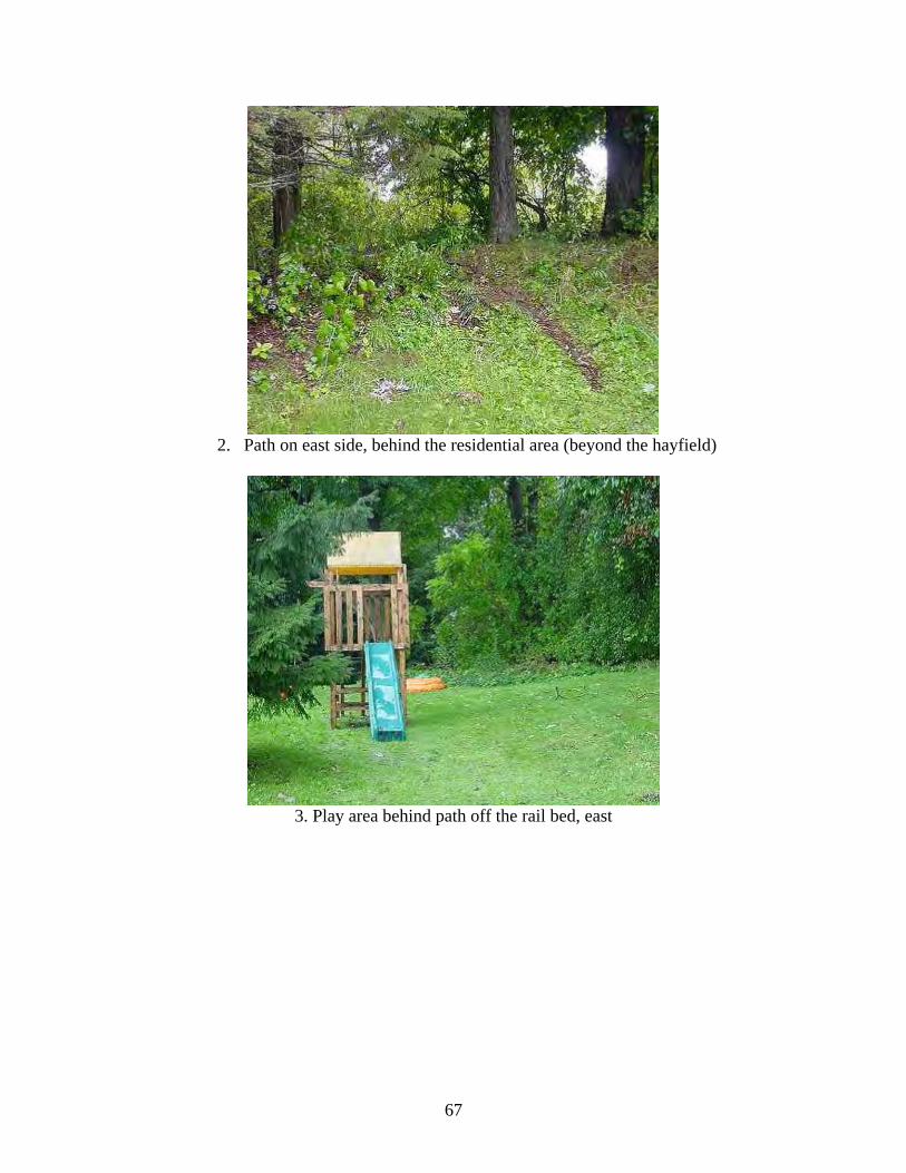
2. Path on east side, behind the residential area (beyond the hayfield)
3. Play area behind path off the rail bed, east
67
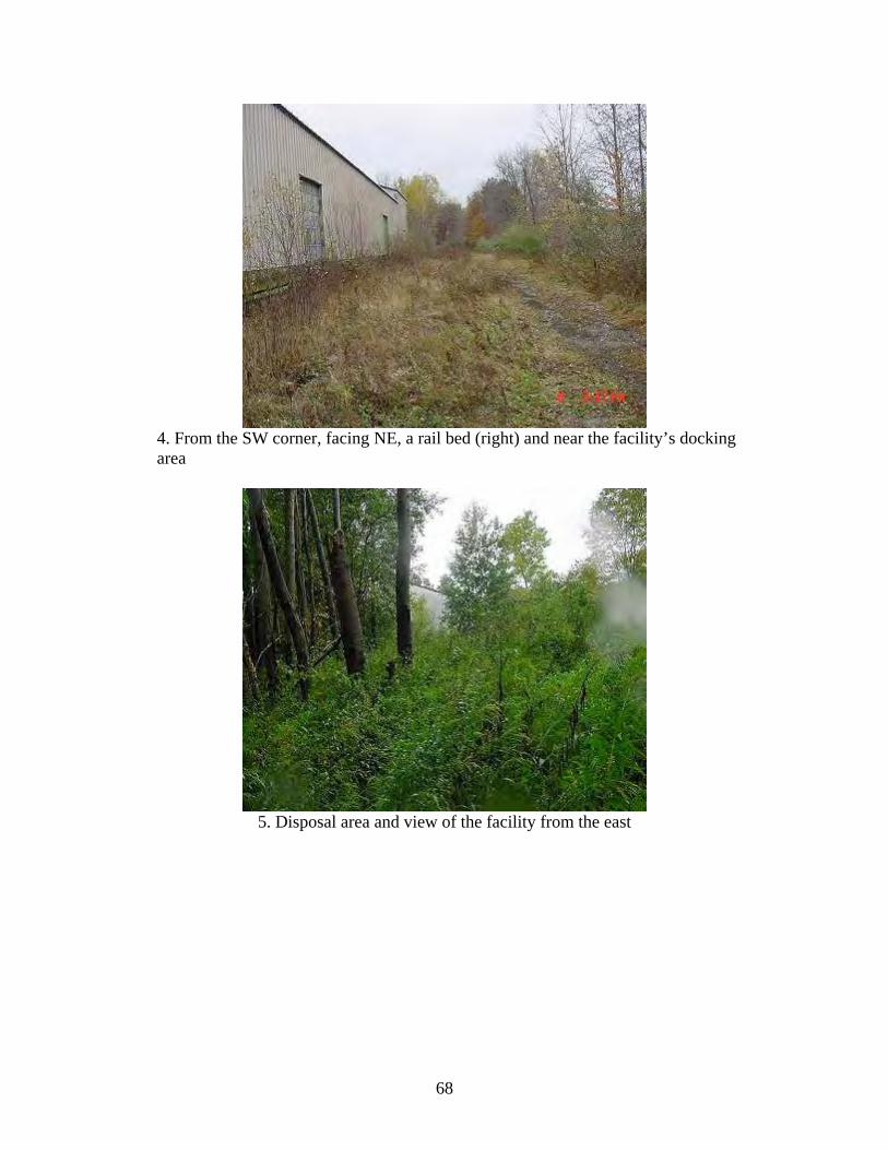
4. From the SW corner, facing NE, a rail bed (right) and near the facility’s docking area
5. Disposal area and view of the facility from the east
68

6. The mound in the disposal area where byproduct was discarded
7. Rusted machinery used to transport vermiculite
69
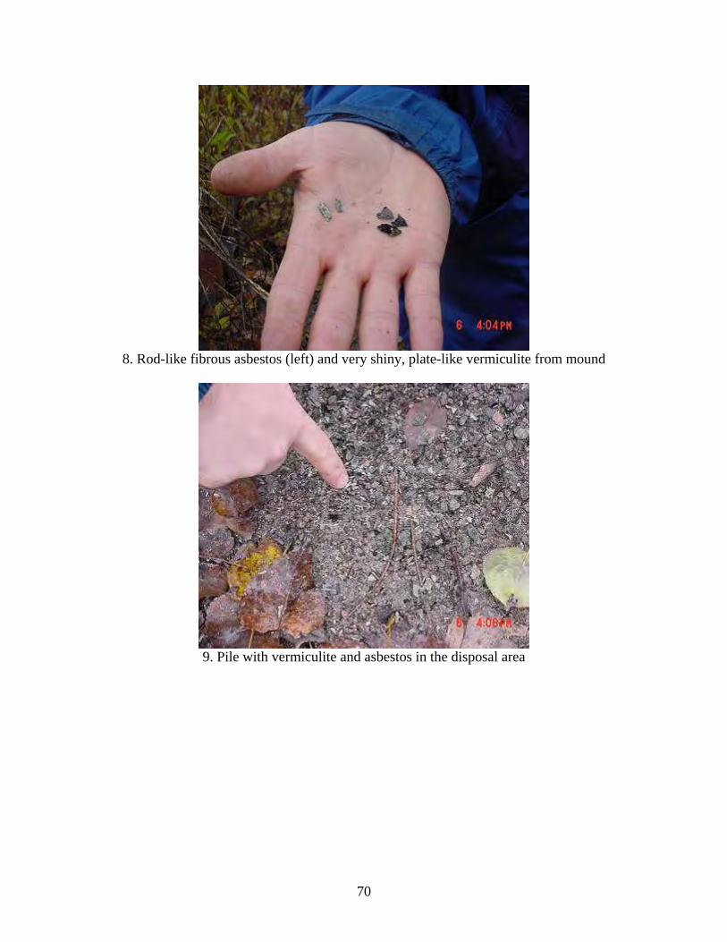
8. Rod-like fibrous asbestos (left) and very shiny, plate-like vermiculite from mound
9. Pile with vermiculite and asbestos in the disposal area
70
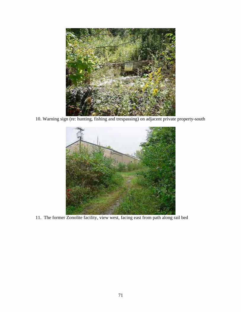
10. Warning sign (re: hunting, fishing and trespassing) on adjacent private property-south
11. The former Zonolite facility, view west, facing east from path along rail bed
71
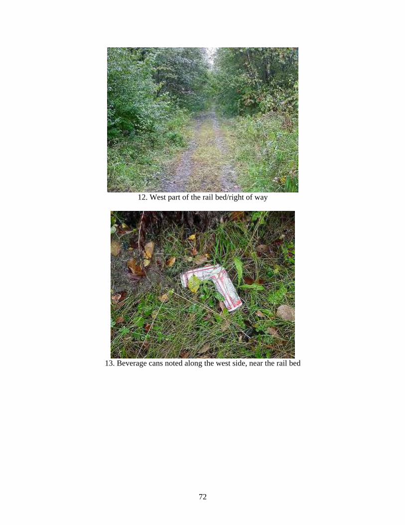
12. West part of the rail bed/right of way
13. Beverage cans noted along the west side, near the rail bed
72
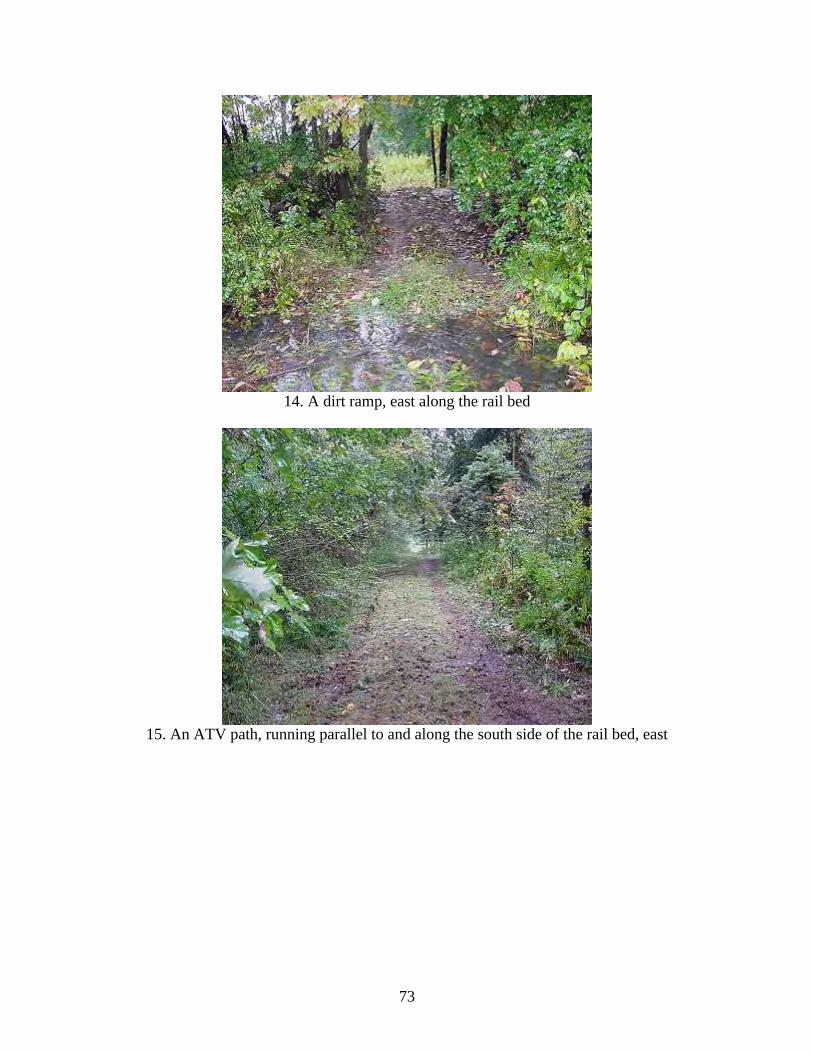
14. A dirt ramp, east along the rail bed
15. An ATV path, running parallel to and along the south side of the rail bed, east
73
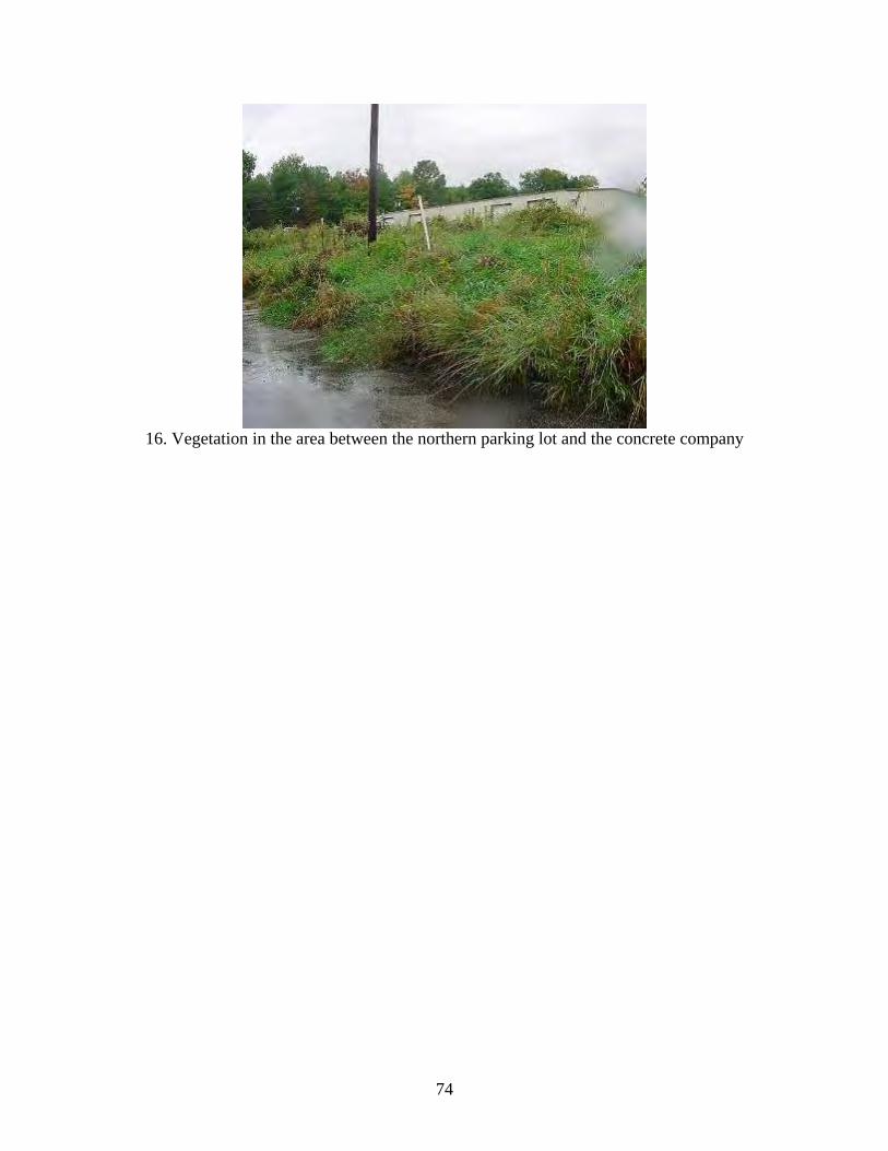
16. Vegetation in the area between the northern parking lot and the concrete company
74
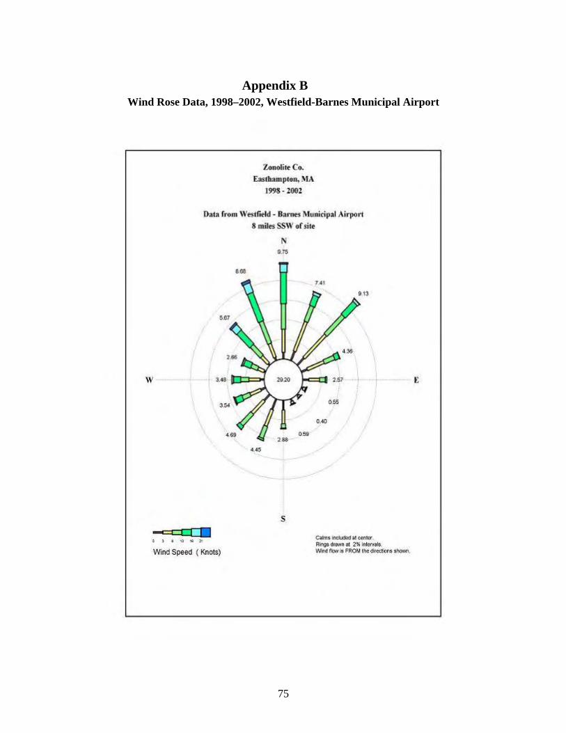
Appendix B Wind Rose Data, 1998–2002, Westfield-Barnes Municipal Airport
75
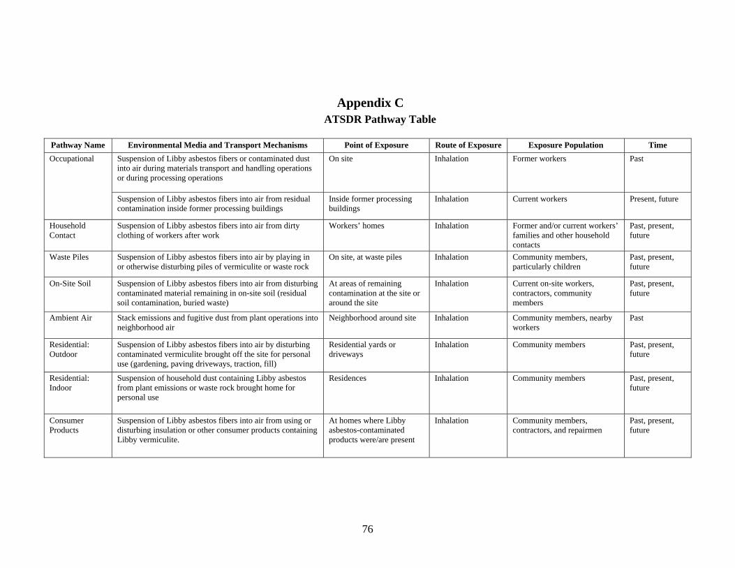
76
Appendix C ATSDR Pathway Table
Pathway Name Environmental Media and Transport Mechanisms Point of Exposure Route of Exposure Exposure Population Time
Suspension of Libby asbestos fibers or contaminated dust into air during materials transport and handling operations or during processing operations
On site Inhalation Former workers Past Occupational
Suspension of Libby asbestos fibers into air from residual contamination inside former processing buildings
Inside former processing buildings
Inhalation Current workers Present, future
Household Contact
Suspension of Libby asbestos fibers into air from dirty clothing of workers after work
Workers’ homes Inhalation Former and/or current workers’ families and other household contacts
Past, present, future
Waste Piles Suspension of Libby asbestos fibers into air by playing in or otherwise disturbing piles of vermiculite or waste rock
On site, at waste piles Inhalation Community members, particularly children
Past, present, future
On-Site Soil Suspension of Libby asbestos fibers into air from disturbing contaminated material remaining in on-site soil (residual soil contamination, buried waste)
At areas of remaining contamination at the site or around the site
Inhalation Current on-site workers, contractors, community members
Past, present, future
Ambient Air Stack emissions and fugitive dust from plant operations into neighborhood air
Neighborhood around site Inhalation Community members, nearby workers
Past
Residential: Outdoor
Suspension of Libby asbestos fibers into air by disturbing contaminated vermiculite brought off the site for personal use (gardening, paving driveways, traction, fill)
Residential yards or driveways
Inhalation Community members Past, present, future
Residential: Indoor
Suspension of household dust containing Libby asbestos from plant emissions or waste rock brought home for personal use
Residences Inhalation Community members Past, present, future
Consumer Products
Suspension of Libby asbestos fibers into air from using or disturbing insulation or other consumer products containing Libby vermiculite.
At homes where Libby asbestos-contaminated products were/are present
Inhalation Community members, contractors, and repairmen
Past, present, future
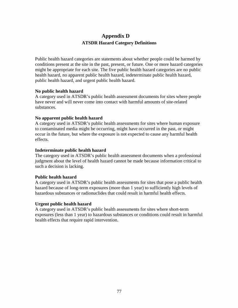
Appendix D ATSDR Hazard Category Definitions
Public health hazard categories are statements about whether people could be harmed by conditions present at the site in the past, present, or future. One or more hazard categories might be appropriate for each site. The five public health hazard categories are no public health hazard, no apparent public health hazard, indeterminate public health hazard, public health hazard, and urgent public health hazard. No public health hazard A category used in ATSDR’s public health assessment documents for sites where people have never and will never come into contact with harmful amounts of site-related substances. No apparent public health hazard A category used in ATSDR’s public health assessments for sites where human exposure to contaminated media might be occurring, might have occurred in the past, or might occur in the future, but where the exposure is not expected to cause any harmful health effects. Indeterminate public health hazard The category used in ATSDR’s public health assessment documents when a professional judgment about the level of health hazard cannot be made because information critical to such a decision is lacking. Public health hazard A category used in ATSDR’s public health assessments for sites that pose a public health hazard because of long-term exposures (more than 1 year) to sufficiently high levels of hazardous substances or radionuclides that could result in harmful health effects. Urgent public health hazard A category used in ATSDR’s public health assessments for sites where short-term exposures (less than 1 year) to hazardous substances or conditions could result in harmful health effects that require rapid intervention.
77
Recommended