Ferrovia
Software for Railway Design and Maintenance
version
2014

Worldwide gauge
support
Support for various rail gauges, cantcalculation and editing methods,custom turnout geometry andeditable cross section geometrymake Ferrovia applicable worldwide.
FerroviaProfessional rail industry 2D/3D software solution for high
speed and conventional rail track design. Including
maintenance and rail track reconstruction tools with
realignment calculations and clearance analysis. Ferrovia
provides a set of comprehensive tools to design small to
very large rail projects.
Highlights Parabolas support
Ferrovia manages complexgeometry designs, supporting linearand nonlinear parabolas forconventional and high speed railtracks design.
Intuitive user
interface
Intuitive ribbon workflows makeFerrovia an easy to master solution.
Customizable
Seamless
integration
Design parameters defined in anexternal XML files provide easycustomization possibilities.
Ferrovia is seamlessly integrated invarious CAD environments,supporting AutoCAD, AutoCAD Civil3D, Bricscad and more.
Integrated
infrastructure
solution
Dynamic update
Ferrovia is part of CGS infrastructuresolution. Integrating road, rail,channel and power lines design.
Manage your design projectchanges with dynamical geometryupdates.
english, german,croatian,
Application:
Web page:
Supported languages:
Railway Design and Maintenance
www.cgsplus.com
AutoCAD Civil 3D, AutoCAD,AutoCAD Map 3D, Bricscad;latest functionality and updates areprovided for current and up to four olderversions of CAD platform.
polish, czech, hungarian,slovenian
Working platform:
Ferrovia application
�
�
�
�
�
�
�
�
�
High speed rail track design;
Conventional rail track design;
Platforms design with junctions and switches;
Large rail track projects support;
Road/rail intersections design
Industrial, underground/metro rail track design;
Light rail design in urban areas;
Rail track geometry calculations and data export totamping machinery;
Rail track envelope clearance analysis;
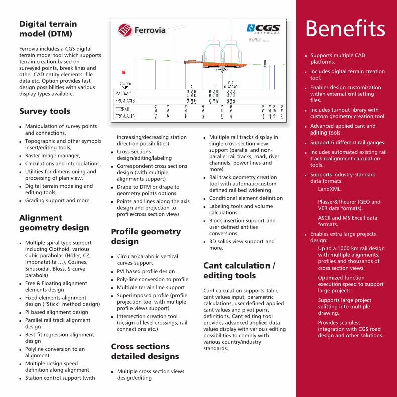
Digital terrain
model (DTM)
Survey tools
Alignment
geometry design
Ferrovia includes a CGS digitalterrain model tool which supportsterrain creation based onsurveyed points, break lines andother CAD entity elements, filedata etc. Option provides fastdesign possibilities with variousdisplay types available.
Manipulation of survey pointsand connections,
Topographic and other symbolsinsert/editing tools,
Raster image manager,
Calculations and interpolations,
Utilities for dimensioning andprocessing of plan view,
Digital terrain modeling andediting tools,
Grading support and more.
Multiple spiral type supportincluding Clothoid, variousCubic parabolas (Höfer, CZ,Imbonatatita …), Cosines,Sinusoidal, Bloss, S-curveparabola)
Free & Floating alignmentelements design
Fixed elements alignmentdesign (“Stick” method design)
PI based alignment design
Parallel rail track alignmentdesign
Best-fit regression alignmentdesign
Polyline conversion to analignment
Multiple design speeddefinition along alignment
Station control support (with
�
�
�
�
�
�
�
�
�
�
�
�
�
�
�
�
increasing/decreasing stationdirection possibilities)
Cross sectionsdesign/editing/labeling
Correspondent cross sectionsdesign (with multiplealignments support)
Drape to DTM or drape togeometry points options
Points and lines along the axisdesign and projection toprofile/cross section views
Circular/parabolic verticalcurves support
PVI based profile design
Poly-line conversion to profile
Multiple terrain line support
Superimposed profile (profileprojection tool with multipleprofile views support)
Intersection creation tool(design of level crossings, railconnections etc.)
Multiple cross section viewsdesign/editing
�
�
�
�
�
�
�
�
�
Profile geometry
design
Cross sections
detailed designs
�
�
�
�
�
�
�
�
Multiple rail tracks display insingle cross section viewsupport (parallel and non-parallel rail tracks, road, riverchannels, power lines andmore)
Rail track geometry creationtool with automatic/customdefined rail bed widening
Conditional element definition
Labeling tools and volumecalculations
Block insertion support anduser defined entitiesconversions
3D solids view support andmore.
Cant calculation supports tablecant values input, parametriccalculations, user defined appliedcant values and pivot pointdefinitions. Cant editing toolprovides advanced applied datavalues display with various editingpossibilities to comply withvarious country/industrystandards.
Cant calculation /
editing tools
Benefits� Supports multiple CAD
platforms.
Includes digital terrain creationtool.
Enables design customizationwithin external xml settingfiles.
Includes turnout library withcustom geometry creation tool.
Advanced applied cant andediting tools.
Support 6 different rail gauges.
Includes automated existing railtrack realignment calculationtools.
Supports industry-standarddata formats:
LandXML.
Plasser&Theurer (GEO andVER data formats).
ASCII and MS Excell dataformats.
Enables extra large projectsdesign:
Up to a 1000 km rail designwith multiple alignments,profiles and thousands ofcross section views.
Optimized functionexecution speed to supportlarge projects.
Supports large projectsplitting into multipledrawing.
Provides seamlessintegration with CGS roaddesign and other solutions.
�
�
�
�
�
�
�
�
�
�
�
�
�
�
�
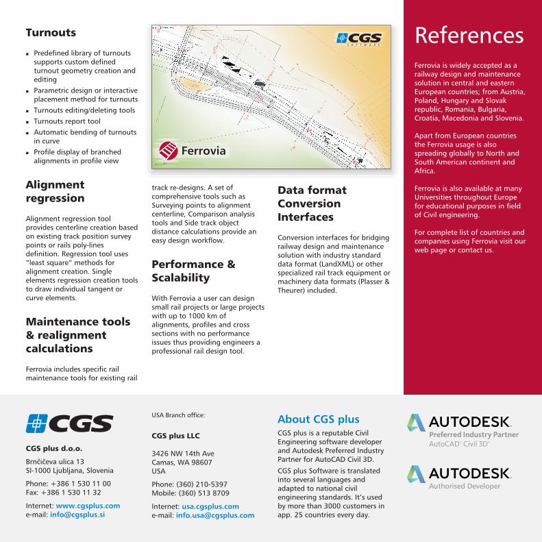
Turnouts
Alignment
regression
Maintenance tools
& realignment
calculations
�
�
�
�
�
�
Predefined library of turnoutssupports custom definedturnout geometry creation andediting
Parametric design or interactiveplacement method for turnouts
Turnouts editing/deleting tools
Turnouts report tool
Automatic bending of turnoutsin curve
Profile display of branchedalignments in profile view
Alignment regression toolprovides centerline creation basedon existing track position surveypoints or rails poly-linesdefinition. Regression tool uses“least square” methods foralignment creation. Singleelements regression creation toolsto draw individual tangent orcurve elements.
Ferrovia includes specific railmaintenance tools for existing rail
track re-designs. A set ofcomprehensive tools such asSurveying points to alignmentcenterline, Comparison analysistools and Side track objectdistance calculations provide aneasy design workflow.
With Ferrovia a user can designsmall rail projects or large projectswith up to 1000 km ofalignments, profiles and crosssections with no performanceissues thus providing engineers aprofessional rail design tool.
Performance &
Scalability
ReferencesFerrovia is widely accepted as arailway design and maintenancesolution in central and easternEuropean countries; from Austria,Poland, Hungary and Slovakrepublic, Romania, Bulgaria,Croatia, Macedonia and Slovenia.
Apart from European countriesthe Ferrovia usage is alsospreading globally to North andSouth American continent andAfrica.
Ferrovia is also available at manyUniversities throughout Europefor educational purposes in fieldof Civil engineering.
For complete list of countries andcompanies using Ferrovia visit ourweb page or contact us.
Data format
Conversion
Interfaces
Conversion interfaces for bridgingrailway design and maintenancesolution with industry standarddata format (LandXML) or otherspecialized rail track equipment ormachinery data formats (Plasser &Theurer) included.
CGS lus d.o.o.p
Brnčičeva ulica 13SI-1000 Ljubljana, Slovenia
Phone: +386 1 530 11 00Fax: +386 1 530 11 32
Internet:
e-mail:
About CGS plusCGS plus is a reputable CivilEngineering software developerand Autodesk Preferred IndustryPartner for AutoCAD Civil 3D.
CGS plus Software is translatedinto several languages andadapted to national civilengineering standards. It’s usedby more than 3000 customers inapp. 25 countries every day.
CGS lusp LLC
3426 NW 14th AveCamas, WA 98607USA
Phone: (360) 210-5397Mobile: (360) 513 8709
Internet:
e-mail:
USA Branch office:
Recommended


![Like us, Follow us, Stay informed ...actv.avmspa.it/sites/default/files/WEB_mappa_linee_di_navigazione... · FERROVIA [Railway Stn.] O [Car Park] O S.MARCO - S.ZACCARIA.le ROMA [Bus](https://img.pdfslide.us/doc/110x75/5c11a92a09d3f263108c42e5/like-us-follow-us-stay-informed-actvavmspaitsitesdefaultfileswebmappalineedinavigazione.jpg)