DESTINATION Region: Marche
Province: Ancona
Area: coastal
LOCATION Location: city center
BUILDING
Ownership: State – Managed by Agenzia del
Demanio
Bid: redevelopment long lease up to 50 years
Period of construction: 19th century
Land area: 1.320 m2
Gross area: 286 m2
Historical-artistic protection: yes
Permitted intended use: cultural uses, commercial
establishments, sport and amusement facilities
FARO COLLE DEI CAPPUCCINI Ancona
Via del Cardeto snc – 60121 Ancona
Lighthouse
20 km
1 km
4 km
12 km
1

Real-estate portfolio, called Faro Colle dei Cappuccini, situated in the
same location, close to the historical centre of Ancona, inside the Park of
Cardeto, in a dominant position, with optimal outlook and a great view on
the Adriatic Coast. The building is not used as a signalling facility
anymore, due to its panoramic position, and is adequate for use as a
touristic and recreational facility for cultural functions. The real-estate
portfolio, which was built in 1860 by Pope Pio IX, is made up of two
buildings used as lighthouses and home of the lighthouse keeper and of
two small rooms totally underground. The building which is to be used for
signalling functions is built by a tower of cylinder form with a brick
structure. The top of the building which can be reached via a spiral
staircase, has an external path and does not have lighting. During a
following period, a building in brick with rectangular plan was added to
the lighthouse, built on two levels, partially underground and on the
ground floor. Close to the lighthouse, the home of the lighthouse keeper
can be found, a building also realized in brick and built on one level, a
little above the level of the countryside. Connected to the buildings there
is a courtyard which is marked by a series of bricks, that from seaside
look over the cliff on the rocks below. The complex, with provision dated
30.09.1977 has been declared of cultural interest according to Law
n°1089/39. The foreseen uses are: public, equipment and entertainment
for show business, sport and cultural, local and association facility
activities and observatories.
FARO COLLE DEI CAPPUCCINI Ancona
Lighthouse
20 km
1 km
4 km
12 km
2

Via Sant’Elena - Località Sant’Elena, Augusta – 96100 Siracusa
DESTINATION Region: Sicilia
Province: Siracusa
Area: coastal
LOCATION Location: extra-urban
BUILDING
Ownership: State – Managed by Agenzia del Demanio
Bid: redevelopment long lease up to 50 years
Period of construction: 20th century
Land area: 1.307 m²
Gross area: 308 m²
Historical-artistic protection: yes
Permitted intended use: touristic activities, hotels,
restaurants, cultural initiatives, territorial social
employment for public use
FARO DI SANTA CROCE Augusta (Siracusa)
45 km
12 km
8 km 8 km
Lighthouse
45 km
12 km
8 km
5 km
3

Maritime signalling facility, denominated “Faro di Capo Santa Croce” ,
situated in the Municipality of Augusta, in the Sant’Elena area, not far
from the City of Siracuse, declared World Heritage Site by UNESCO in
2005. The lighthouse, built in 1859, rises on a rocky promontory on white
limestone facing the Ionian Coast. The building due to its location is
adequate to be used as a recreation and touristic facility or for technical
and scientific activities. The building which is situated on a cliff
overlooking the sea, is on a Lot of 1,307 m² of buildable land, and is
made up of two factories, both on the same level. The first, which has a
gross area of approximately 308 m², includes the lighthouse with the
connected service housing of the past lighthouse keeper, while the
second factory is made up of a room at an above ground floor of 60 m².
The two buildings are connected by a small brick bridge that goes above
the normal level of the land; the property has borders on three sides with
State Property and with a public road. The building has been declared of
cultural interest according to Article 1 of Law n°1089/39 and Article 2 of
Law 80/77 and presents a Landscape protection bond according to ex
article 136 and 142 of Legislative Decree n°42/2004. The real-estate
portfolio can be transformed into a touristic, recreational, scientific and
cultural facility excluding the part of the land that is in State use
(indicated on the map with building registry parcel B) for which the public
service utility will be maintained (State use for the Ministry of Defence).
External spaces can be valued with the realization of areas which will be
used for accessibility, for services and for other equipment,
For all that regards the landscape
standards, an agreement with the
Municipality can be made for their
realization close to the building and the
monetization.
Restoration and renovation (technically
Rr) is foreseen and/or Building Renovation
of type A (Rie A) in the modalities defined
in the Building Regulation of the General
Regulation Plan of the City of Augusta and
according to the indications and
prescriptions defined by the
Superintendence for Cultural and
Environmental Heritage of Siracuse.
45 km
12 km
8 km 8 km
Lighthouse
45 km
12 km
8 km
5 km
FARO DI SANTA CROCE Augusta (Siracusa)
4

Sentiero al Semaforo Nuovo – Parco di Portofino – Camogli (GE)
DESTINATION
Region: Liguria
Province: Genova
Area: coastal
LOCATION
Location: suburban
BUILDING
Ownership: State - Managed by Agenzia del Demanio
Bid: redevelopment long lease up to 50 years
Period of construction: between 1880 and 1890
Land area: 5.883,86 m2
Gross area: 260,28 m2
Historical-artistic protection: yes
Permitted intended use: touristic activities, hotels,
restaurants, cultural initiatives, territorial social
employment for public use
SEMAFORO NUOVO DI CAMOGLI Camogli (Genova)
44 km
42 km (Porto di
Genova)
12 km (Porticciolo
Camogli)
19 km (Porticciolo
Portofino)
11 km
13 km
Lighthouse
5

44 km
42 km (Porto di
Genova)
12 km (Porticciolo
Camogli)
19 km (Porticciolo
Portofino)
11 km
13 km
The property called “Semaforo Nuovo” is made up of two buildings, the
signalling tower and the security personnel housing, built around the end
of the 1800s after the unification of Italy, as an important part of the
coastal traffic lighting. Both the buildings, part of the large uncovered land
of about 5,900 m², are built on two floors, with a flat covering and areas
with an essential look, adorned by a floor sign, with dark Genovese
window fixtures. The traffic light maintains the characteristic signalling
tower, from which it is possible to look over the entire Ligurian Gulf. The
property is entirely on the Regional Natural Park of Portofino; at the
moment free and in good maintenance conditions, in the past it was used
first by the Italian Navy then by the State Forestry Corps as a district for
environmental protection. The property, for its historical value, is
considered of cultural interest according to Article 10, comma 1) of
Legislative Decree dated 22 January 2004, n°42, pursuant to Decree of
the Ministry of heritage and cultural activity. The property is located in an
extra-urban zone, in the Municipality of Camogli (5,342 inhabitants),
included in the metropolitan area of Genova (850,071 inhabitants) in the
area Semaforo Nuovo, situated on a promontory of Portofino on a cliff on
the sea; the area is close to Punta Chiappa, Cala dell’Oro and the
residential area of San Fruttuoso of Capodimonte.
SEMAFORO NUOVO DI CAMOGLI Camogli (Genova)
Lighthouse
6

Piazza Santa Maria de Nives, loc. Schiavonea di Corigliano Calabro (CS)
132 km
2,4 km
13,4 km
8,3 km
DESTINATION Region: Calabria
Province: Cosenza
Area: coastal
LOCATION Location: extra-urban;
BUILDING
Ownership: State - Managed by Agenzia del Demanio
Bid: redevelopment long lease up to 50 years
Period of construction: 20th century
Land area: 550.00 m2
Gross area: 190.00 m2
Historical-artistic protection: yes
Permitted intended use: touristic activities, hotels,
restaurants, cultural initiatives, territorial social
employment for public use
TORRE DEL CUPO Corigliano Calabro (Cosenza)
Tower
7

TORRE DEL CUPO Corigliano Calabro (Cosenza)
The real-estate portfolio, built in the 17th century has a plan with four
corners, typical of fortified buildings; it has two levels above the ground
as well as the covered floor, it has a terrace on which a walkway is built
which has spaces along the perimeter, with small openings on all sides.
The building is part of control towers along the Calabrian coast which
were built during the Saracen period. The building on the basis of
restrictions pursuant to the General Regulation Plan in force, is part of the
“Completion zone B3 according to the building programme.
The building is situated in the Municipality of Corigliano Calabro (40,426
inhabitants) in the Province of Cosenza (711,739 inhabitants), 6th
Municipality of the Calabria Region for amount of population resident
(1,965,128 inhabitants) in the area of Schiavonea, in the main square of
the small marine quarter, 300 m. from the beach. The city is in the Sibari
Plain, the biggest plain in Calabria, on the northern Ionian side of the
Region between the Pollino National Park and the Sila National Park, on
of the biggest natural and fauna oasis’ in the South of Italy. Road
accessibility is guaranteed by the National Road SS 106 (Ionian), coastal
road that connects Taranto with Reggio Calabria, and almost touches the
city nearby the building.
132 km
2,4 km
13,4 km
8,3 km
Tower
8

DESTINATION
Region: Sicilia
Province: Catania
Area: port
LOCATION
Location: urban
BUILDING
Ownership: State - Managed by Agenzia del Demanio
Bid: redevelopment long lease up to 50 years
Period of construction: 20th century
Land area: 470 m2
Gross area: 120 m2
Historical-artistic protection: yes
Permitted intended use: touristic activities, hotels,
restaurants, cultural initiatives, territorial social
employment for public use
Via Duca degli Abruzzi n. 2 – 95018 Riposto (CT)
44 km
36 km
2 km
5 km
FARO DI RIPOSTO Riposto (Catania)
Lighthouse
DESTINATION Region: Sicilia
Province: Catania
Area: port
LOCATION Location: urban
BUILDING
Ownership: State - Managed by Agenzia del Demanio
Bid: redevelopment long lease up to 50 years
Period of construction: 20th century
Land area: 470 m2
Gross area: 120 m2
Historical-artistic protection: yes
Permitted intended use: touristic activities, hotels,
restaurants, cultural initiatives, territorial social
employment for public use
9

FARO DI RIPOSTO Riposto (Catania)
44 km
36 km
2 km
5 km
Lighthouse
10
Lighthouse built in 1911, close to the sea, in the Municipality of
Riposto, on the eastern coast of Sicily. The property, located in the port
area, can be redeveloped as lighthouse accommodation with
restaurant, recreational didactic and promotional activities. The square
shaped building dominated by an embattled tower, was built in 1911
and is positioned above the road and surrounded by a garden. It
consists of two floors: the ground floor from which a staircase reaches
the tower, with access to a dome-shaped cover that protects the
lighthouse. The lighthouse was operational until 1992, when it was
transferred to the present day pier. The Coast Guard offices have been
recently built close to the building. The property is currently completely
abandoned and is used as deposit by the harbour office. The covered
surface is 120 m², as well as a terrace of 96 m² on the first floor and a
small garden on the ground floor. The property will remain the property
of the state and leased to third parties for redevelopment. The
structure, due to its location, is ideally suited for redevelopment in a
tourist- accommodation structure and restaurant activities or cultural or
social events to promote the local territory open to the public.

200 km
4 km
120 km
120 km
S.S. 89 Garganica - Peschici (FG)
DESTINATION Region: Puglia
Province: Foggia
Area: coastal
LOCATION Location: suburban
BUILDING
Ownership: State - Managed by Agenzia del Demanio
Bid: redevelopment long lease up to 50 years
Period of construction: XXVIth century
Superficie territoriale/Land area: 105 m2
Gross area: 70 m2
Historical-artistic protection: yes
Permitted intended touristic activities, hotels,
restaurants, cultural initiatives, territorial social
employment for public use
TORRE MONTE PUCCI Peschici (Foggia)
Tower
11

120 km
TORRE MONTE PUCCI Peschici (Foggia)
Coastal lookout tower built on a very steep cliff. The property, which has
a square plan that has a structure that looks like a pyramid that has been
cut, is on two levels with a terrace, on which there is a tiny tower and a
chimney. The entrance is towards the mountains, on the upper level, with
a stone stairway and metal railing, whereas the second entrance is on
the ground floor, on the East side; inside there is a wooden loft with its
own stairway. The structure of the building in brick made up of stone
blocks and flat roofing with a boulder slope. As confirmed by the recent
uses of the property, and while waiting for the MiBACT (Heritage Ministry)
indications, it is believed that its vocation is to be considered that of a
property for touristic and recreational uses. It has the following
restrictions: Landscape, according to Legislative Decree 42/2004 (Articles
136 and 137); Historical-Artistic, with declaratory registered n° 11841
dated 4/12/2012; National Park of Gargano – zone 2, according to
Decree of the President of the Republic dated 5 June 1995; Hydrological
restriction, according to Regio Decree dated 30 December 1923, n°3267.
Property located in the Municipality of Peschici (4,511 inhabitants) well
known seaside location highly attended during the Summer season, in
Province of Foggia (628,556 inhabitants) in the Apulia Region (4,063,888
inhabitants), inside the National Park of Gargano, with main entrance
along State Road 89 Garganica at km. 80,500. The real-estate portfolio is
5 km. from the centre of Peschici and the Medieval Castle; very close you
can find beachfront resorts, bays and a trebuchet used as a restaurant.
The Municipalities of Vieste and Rodi Garganico, strongly devoted to
tourism, are 25 km. away.
200 km
4 km
120 km
120 km
Tower
12

18 km
4 km
5 km
5 km
Viale Virgilio - Taranto
DESTINATION Region: Puglia
Province: Taranto
Area: coastal
LOCATION Location: peri-urban
BUILDING
Ownership: State – Managed by Agenzia del Demanio
Bid: redevelopment long lease up to 50 years
Period of construction: XVIIIth century
Land area: 4.158 m²
Gross area: 1.875 m²
Historical-artistic protection: yes
Permitted intended use: touristic activities, hotels,
restaurants, cultural initiatives, territorial social
employment for public use
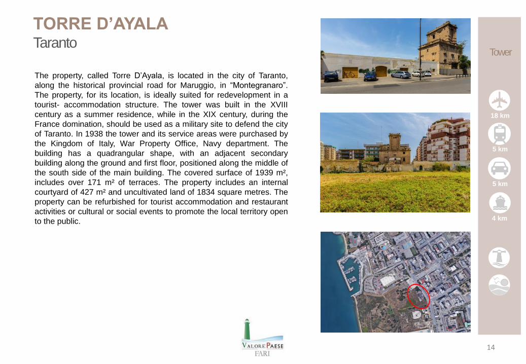
TORRE D’AYALA Taranto
Tower
13
5 km
TORRE D’AYALA Taranto
18 km
4 km
5 km
5 km
Tower
14
The property, called Torre D’Ayala, is located in the city of Taranto,
along the historical provincial road for Maruggio, in “Montegranaro”.
The property, for its location, is ideally suited for redevelopment in a
tourist- accommodation structure. The tower was built in the XVIII
century as a summer residence, while in the XIX century, during the
France domination, should be used as a military site to defend the city
of Taranto. In 1938 the tower and its service areas were purchased by
the Kingdom of Italy, War Property Office, Navy department. The
building has a quadrangular shape, with an adjacent secondary
building along the ground and first floor, positioned along the middle of
the south side of the main building. The covered surface of 1939 m²,
includes over 171 m² of terraces. The property includes an internal
courtyard of 427 m² and uncultivated land of 1834 square metres. The
property can be refurbished for tourist accommodation and restaurant
activities or cultural or social events to promote the local territory open
to the public.

Laguna di Venezia, Fronte Ponte della Libertà, Venezia (VE)
6 km
1 km
1 km
3 km
DESTINATION Region: Veneto
Province: Venezia
Area: coastal
LOCATION Location: extra-urban
BUILDING Ownership: State – Managed by Agenzia del
Demanio
Bid: redevelopment long lease up to 50 years
Period of construction: 11th century
Land area: 12.921 m²
Gross area: 745 m²
Historical-artistic protection: yes
Permitted intended use: touristic activities, hotels,
restaurants, cultural initiatives, territorial social
employment for public use
ISOLA DI SAN SECONDO Venezia
Island
15

6 km
1 km
1 km
3 km
ISOLA DI SAN SECONDO Venezia
The Island of San Secondo is in the part of the Venetian lagoon near the
rail bridge in the direction of San Giuliano. Already used during the 11th
century as a place of worship and monastery, the island has hosted over
the centuries diverse religious buildings, and their vicissitudes have
marked the architectural history of small settlements, leaving many
historical testimonials until the Napoleonic government that with decree
made the Domenican religious people, last occupants if the island, move
away. In 1847 a small fortress was built according to typical Austrian
criteria that transforms de facto the area in a military district replacing the
pre-existing church and protecting the banks with an artificial shore in
store. A small dock has also been built to guarantee safe berthing in the
central part of the property, that is made up of three ammunition
warehouses and a tank. The wall implant is still visible with the tri-lobal
plan, notwithstanding that for decades it was unused and not taken care
of. While waiting for a restoration and enhancement activity, the Municipal
administration has disposed for the future of the property the compatibility
both with residential and touristic-recreational functions, in the maximum
respect of the eighteenth century buildings as the provisions of safeguard
foreseen by the Ministry of Cultural Heritage lay down (pursuant to
Legislative Decree n°42/2004).
6 km
1 km
1 km
3 km
Island
16

Laguna di Venezia, Loc. Ca’ Roman, 30126 Venezia (VE)
30 km
2 km
25 km
30 km
DESTINATION Region: Veneto
Province: Venezia
Area: coastal
LOCATION Location: extra-urban
BUILDING Ownership: State – Managed by Agenzia del Demanio
Bid: redevelopment long lease up to 50 years
Period of construction: 5th century
Land area: 1.810 m2
Gross area: 252 m2
Historical-artistic protection: yes
Permitted intended use: tourist and cultural
accomodation, services, housing
ISOLA OTTAGONO DI CA’ ROMAN Venezia
Island
17

ISOLA OTTAGONO DI CA’ ROMAN Venezia
30 km
2 km
25 km
30 km
Island
18
The Ottagono di Ca' Roman is an island of the lagoon of Venice
situated in front of the Ca’ Roman area, at Pellestrina. The island is
part of the fortification system that the Republic of Venice built against
the Turkish menace around half of the 1400s, then modified during the
Austrian domination and used as a fortress until the Second World
War. The real-estate portfolio, due to its characteristics and its
location, is adequate for touristic, recreational and residential use. The
Ottagono di Ca’ Roman is part of the complex of lagoon fortifications
realized by the Republic of Venice to defend itself from the menace of
invasion on behalf of the Ottoman Empire. Probably completed in its
present form in 1571, it was built on a pre-existent military property
made of rocks and pile houses, modified under the Austrian
domination and used for military purposes until the Second World War.
The real-estate portfolio is made up of an island that is basically of
octagonal shape complete with fortified walls and bunker, on which two
small armouries are present that today have almost collapsed. The
confinement of the island is composed of a thick wall placed on a base
made of Istrian Stone. On the three northern sides a basement bunker
is present, realized in brick, with a vaulted ceiling and made up of
holes that look onto the lagoon water. For the entire surface, a
residential use is foreseen as well as for group facilities, in conformity
with the landscape tools that are in force in the Municipality of Venice.
For the entire outdoor surface the realization of areas destined for
accessibility, for services and other equipment is foreseen.

Sea and relax - The circuit Itinerary with a strong historical and naturalistic value, mainly coastal, focused on the discovery of sea culture. Types of dwelling: coastal and lighthouses.
Nature dwelling A prestigious building set in a context of high environmental and natural value. Arch type: military, civil, religious, industrial, palace, castle, villa, farm.
Coastal residence and lighthouses Constructed in a strong coastal landscape and linked to the culture of the sea. Arch type: military, civil, religious, industrial, palace, villa, tower lighthouse and coastal building.
Island Small island entirely devoted to dwelling. Arch type: island.
19
Recommended