p NAMIBIA UNIVERSITY OF SCIENCE AND TECHNOLOGY
FACULTY OF NATURAL RESOURCES AND SPATIAL SCIENCES
DEPARTMENT OF ARCHITECTURE AND SPATIAL PLANNING
QUALIFICATION: Bachelor of Town and Regional Planning
QUALIFICATION CODE: O7BTAR LEVEL: 6
COURSE CODE: PLP6215 COURSE NAME: Principles and Guidelines for Layout
Planning
SESSION: November 2019 PAPER: THEORY
DURATION: 3 HOURS MARKS: TOTAL 100
FIRST OPPORTUNITY EXAMINATION QUESTION PAPER
EXAMINER(S) | Mr. Jacques Korrubel / 207 2683 / [email protected]
MODERATOR: | MS. Kristy Asino / 207 2244 / [email protected]
INSTRUCTIONS
Answer ALL the questions.
Write clearly and neatly.
Number the answers clearly.
PWN b
The addition of sketches to answers is recommended
PERMISSIBLE MATERIALS
1. Calculator, ruler, pencil and eraser
THIS QUESTION PAPER CONSISTS OF 5 PAGES (Including this front page)

Principles and Guidelines for Layout Planning PLP621S
Question 1
The picture below illustrates one of the generic forms of Hard Open Spaces within urban settlements.
ye Sy ts SF
a oh Nn pi ui
oth : Thai i
ne
'
j a7 A Harbor Boulevard _at-Fifth Street looking north “y i
(a) Name this generic form of Hard Open Spaces. (1)
(b) List the categories of qualitative and quantitative design guidelines that could be used
to improve the design of this generic form of Hard Open Spaces. (5)
[6]
Question 2
In order to compile a base map of an area that will be subjected to the planning and designs of
layouts, certain land use planning control and management documents must be consulted.
(a) Name these land use planning control and management documents. (3)
(b) Highlight the information contained in these documents that will assist planners in
the design and planning of layouts. (10)
[13]
First Opportunity Question Paper Page 2 of 5 November 2019
Principles and Guidelines for Layout Planning PLP621S
Question 3
The configuration of junctions within movement networks results in certain networks being
classified as either “open” or “closed” movement networks.
(a) List the generic movement networks from the most open network to the one that
is seen as a totally closed network. (5)
(b) Provide sketches of the movement networks listed in 3.(a) above to illustrate their
level of openness or closeness. (5)
[10]
Question 4
The placement of public institutions and recreational facilities inside or in between
neighbourhoods are guided by the structural design principle of “accommodating sameness and
diversity”. In what way would you apply this structural design principle in your neighbourhood
design?
[6]
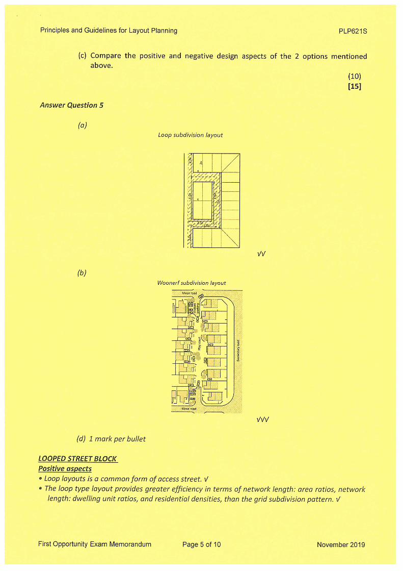
Question 5
When land is subdivided town planners can use various generic street block subdivision options.
(a) Provide a detailed sketch of the Looped street block option. (2)
(b) Provide a detailed sketch of the Woon Erf street block option. (3)
(c) Compare the positive and negative design aspects of the 2 options mentioned
above.
(10) [15]
Question 6
The installation of a sewer network is critical for the safeguarding of residential developments in a
settlement. Describe what layout implications a storm water management service will have on the
design of a settlement.
[8]
First Opportunity Question Paper Page 3 of 5 November 2019

Principles and Guidelines for Layout Planning PLP621S
Question 7
Parramatta Transport Interchange A) bus services Key a ree r= mo compas Kies & Rice
pal #2 eax] cect 7.786. OS ie er + -* Signalised Crossing ream m, 1, ot 00,601,623, LIFTS STAIRS AND pte ar sume er, | Sea ae lll Pedestrian Cressing
a Commercial manga, (eae Bat 546, S47, 550, Pe zi TO AULPATrOns pc Commerce iy Seman ge shan fi Pececvian Access > Ae Ts
bowen | POATFORM 1 ’ oo MIGHTRDE Disabled Access
TZWILIAI "| Escauatan access GQ Busse ARGYLE & AM yy | Escal ut Services Siacersa Weeniien ere areal TO ALL PLATFORMS = = ™ a
TEOMA? ation 5| UNDERGROUND El ee | TS ConchSenices 5 PEDESTRIAN Access | -< MQ ba Coss La in BETWEEN PARRAMATTA [oo ast 21. pie i STATION AND ARGYLE < Ore (Cte EEE eee fat Tati tank A STATION STREETS S45, $46,547, 603", 700,705, soz, set, $04 $46,547, a ap ~ S05, 510 mopsencese $80,600,601, 708.708. 711, rears tien he 1, orntonen 7
Me 06, 808.808 G79, 57, = : aces a7, Bauer's b
0,811 a m
Valentine Macquarie uns iM Tower = Plaza vei or mat oot Kiss & RIO. Gra Coach Sunde ro Sahil
ee Sen ae Wy NIGHTRIDE Att Tp al burs depart oom te é ‘SS PY Taxi Rank Na, N70 Nighesate orous at ronhs AY and B2
tte aN od tO a. Train tickets are available for purchase in the Eastern and Western concourses of Parramaatia Station.
Sa, x The illustration above depicts a public transport interchange. The locality of such a transport
interchange is guided by certain structural principles of settlement design.
(a) Identify the specific structural principle. (1)
(b) Provide a sketch, inclusive of a proper legend, illustrating this structural principle. (6)
(c) Explain the theory / methodology behind this structural principle to achieve structure and
order within human settlements. (6)
[13]
Question 8
Specific locational guidelines / rules exist for the planning and design of soft open spaces. Provide
the specific locational guidelines for the following generic forms of soft open spaces:
(a) Formal parks (3)
(b) Sport fields (3)
(c) Urban agriculture (4) [10]
First Opportunity Question Paper Page 4 of 5 November 2019
Principles and Guidelines for Layout Planning PLP621S
Question 9
In order to compile a base map of an area that will be subjected to the planning and designs of
layouts, certain cadastral information documents must be consulted which focus purely on the
physical characteristics of an area. List the information contained in following documents that
could assist a planner with their layout designs.
(a) Topographical maps (5)
(b) Aerial photos (3)
(c) Orthophotos (3)
(d) Geographical survey maps (3)
[14]
Question 10
If an urban settlement is monitored and evaluated in terms of its performance qualities and it
seems to promote higher population densities which foster specialisation and diversification of
economic activities, it can be concluded that one of the performance qualities are well
established.
(a) Name the specific performance quality described above. (1)
(b) Provide evidence of other outcomes of applying this performance quality in the
design of urban settlements (4)
[5]
END Total [100]
First Opportunity Question Paper Page 5 of 5 November 2019

p NAMIBIA UNIVERSITY OF SCIENCE AND TECHNOLOGY
FACULTY OF NATURAL RESOURCES AND SPATIAL SCIENCES
DEPARTMENT OF ARCHITECTURE AND SPATIAL PLANNING
QUALIFICATION: Bachelor of Town and Regional Planning
QUALIFICATION CODE: 07BTAR LEVEL: 6
COURSE NAME: Principles and Guidelines for Layout
Planning
SESSION: November 2019 | PAPER: THEORY
DURATION: 3 Hours — MARKS: Total 100
COURSE CODE: PLP621S
FIRST OPPORTUNITY EXAMINATION MEMORANDUM
_EXAMINER(S) | Mr. Jacques Korrubel / 207 2683 / [email protected] MODERATOR: Ms. Kristy Asino / 207 2244 / [email protected]
INSTRUCTIONS
1. The model answers are used as guidelines only.
2. The information presented by the students will be evaluated on merit.
THIS MEMORANDUM CONSISTS OF 10 PAGES (Including this front page)

Principles and Guidelines for Layout Planning PLP621S
(a) Name these land use planning control and management documents. (3)
(b) Highlight the information contained in these documents that will assist planners in
the design and planning of layouts. (10)
[13] Answer Question 2:
(a) Policy Areas and Policy Plans V
Town Planning Schemes V
Structure Plans V
Policy Areas and Policy Plans
o Future land use changes V
o Land use and building restrictions in certain areas V
Town Planning Schemes
o Land use and building control measures and regulations V
o Erf zonings and building lines V
o Movement network reserves V
o Demarcation of policy areas V
Structure Plans
o Long term development direction and scenarios V
o Major new land uses and developments expected V
o Future bulk infrastructure developments V
o Locality of new park, open spaces & recreational areas V
Question 3
The configuration of junctions within movement networks results in certain networks being
classified as either “open” or “closed” movement networks.
(a) List the generic movement networks from the most open network to the one that
is seen as a totally closed network. (5)
(b) Provide sketches of the movement networks listed in 3.(a) above to illustrate their
level of openness or closeness. (5)
[10] Answer Question 3
(a) (must be in correct order)
e Rectangular, multidirectional grid network V
e Distorted rectangular, multidirectional grid network V
e Radial multi directional network V
e Looped, hierarchical network V
e Branched hierarchical network V
First Opportunity Exam Memorandum Page 3 of 10 November 2019
Principles and Guidelines for Layout Planning PLP621S
(c) Compare the positive and negative design aspects of the 2 options mentioned above.
(10) [15]
Answer Question 5
(a) Loop subdivision layout
SSN
SENS
SAN RIAN
BS RS HS
PO ARS
LY
Woonerf subdivision layout
Minor road LY
(d) 1 mark per bullet
LOOPED STREET BLOCK
Positive aspects
¢ Loop layouts is a common form of access street. V
e The loop type layout provides greater efficiency in terms of network length: area ratios, network
length: dwelling unit ratios, and residential densities, than the grid subdivision pattern. V
First Opportunity Exam Memorandum Page 5 of 10 November 2019

Principles and Guidelines for Layout Planning PLP621S
Bus Services
aT (ad
700, 705, 205.
ruven? Parramatta Tae AOR “Station
‘Wightsate wroes af roska AZ ond 82
Train tickets are available for purchase in the Eastern and Western coacourses of Parramatta Station.
The illustration above depicts a public transport interchange. The locality of such a transport
interchange is guided by certain structural principles of settlement design.
(a) Identify the specific structural principle. (1)
(b) Provide a sketch, inclusive of a proper legend, illustrating this structural principle. (6)
(c) Explain the theory / methodology behind this structural principle to achieve structure and
order within human settlements. (6)
[13]
Answer Question 7
(a) The structural principle of reinforcement V
<1 5 to2km |
LEGEND
A. Road-based public transport and private vehicles on high order limited-access routes: bus, taxi and private
vehicles.
B. Heavy rail-based public transport: train. C. Light rail-based and road-based public transport as well as private vehicles: tram, bus, taxi, private vehicles.
1. First order centre. All modes of transportation.
2. Second order centre. Mixed transportation: train, bus, taxi, private vehicle, walk.
(b) 3. Local order centre. Local transportation: taxi, private vehicle, bicycle, walk.
First Opportunity Exam Memorandum Page 7 of 10 November 2019

Principles and Guidelines for Layout Planning PLP621S
(c) 1 mark per bullet
e Located next to sources of irrigation water, in the form of rivers, storm water
retention ponds and oxidation pondsV
Located close to low income residential area to limit travel expensesV
Located close to local marketsV
Located within under-utilized land such as servitudesV
Question 9
In order to compile a base map of an area that will be subjected to the planning and designs of
layouts, certain cadastral information documents must be consulted which focus purely on the
physical characteristics of an area. List the information contained in following documents that
could assist a planner with their layout designs.
(a) Topographical maps
(b) Aerial photos
(c) Orthophotos
(d) Geographical survey maps
Answer Question 9:
(a) Topographical maps
Bulk infrastructure and public facilities V
Natural features and land marks V
Contours V
LO or UTM coordinate system & trig beacons V
Data to calculate gradient and conduct a slope analysis V
(b) Aerial photos
Image of real life, up to date picture of physical developments V
Provides for stereoscopic analysis of terrain V
Identifiable land uses and structures and land use & density surveys V
(c) Orthophotos
Provides scale correct mosaic of aerial photos V
Contour lines V
Baseline information for draft conceptual designs V
(d) Geographical survey maps
Geological conditions and classifications V
Soil and mineral classifications V
First Opportunity Exam Memorandum Page 9 of 10 November 2019

November 2019
PLP621S
Principles and Guidelines for Layout Planning
Included:
Moderator’s report
Ist Opportunity question paper
1$* Opportunity Memorandum
Recommended