ENSO’s Modulation of Water Vapor Transport over the Pacific–NorthAmerican Region
HYE-MI KIM
School of Marine and Atmospheric Sciences, Stony Brook University, Stony Brook, New York
MICHAEL A. ALEXANDER
NOAA/Earth System Research Laboratory, Boulder, Colorado
(Manuscript received 23 October 2014, in final form 6 February 2015)
ABSTRACT
The vertically integrated water vapor transport (IVT) over the Pacific–North American sector during three
phases of ENSO in boreal winter (December–February) is investigated using IVT values calculated from the
Climate Forecast System Reanalysis (CFSR) during 1979–2010. The shift of the location and sign of sea
surface temperature (SST) anomalies in the tropical Pacific Ocean leads to different atmospheric responses
and thereby changes the seasonal mean moisture transport into North America. During eastern Pacific El
Niño (EPEN) events, large positive IVT anomalies extend northeastward from the subtropical Pacific into thenorthwestern United States following the anomalous cyclonic flow around a deeper Aleutian low, while asouthward shift of the cyclonic circulation during central Pacific El Niño (CPEN) events induces the transportof moisture into the southwestern United States. In addition, moisture from the eastern tropical Pacific istransported from the deep tropical eastern Pacific into Mexico and the southwestern United States duringCPEN. During La Niña (NINA), the seasonal mean IVT anomaly is opposite to that of two El Niño phases.Analyses of 6-hourly IVT anomalies indicate that there is strongmoisture transport from theNorth Pacific intothe northwestern and southwestern United States during EPEN and CPEN, respectively. The IVT is maxi-mized on the southeastern side of a low located over the eastern North Pacific, where the low is weaker butlocated farther south and closer to shore during CPEN than during EPEN. Moisture enters the southwesternUnited States from the eastern tropical Pacific duringNINA via anticyclonic circulation associated with a ridgeover the southern United States.
1. Introduction
Heavywinter precipitation in thewesternUnited States
is significantly affected by long narrow bands of water
vapor transport from the tropical/subtropical North Pa-
cific into midlatitudes. Often these water vapor plumes
originate near Hawaii and are known colloquially as the
‘‘PineappleExpress’’ (e.g., Lackmann andGyakum1999).
The more general case of strong tropical–extratropical
water vapor transport was termed ‘‘tropospheric rivers’’
by Newell et al. (1992) and then ‘‘atmospheric rivers’’
(ARs) by Zhu and Newell (1998). ARs generally occur
ahead of cold fronts associated with winter storms. The
maximum number of ARs occurs over the northeastern
Pacific Ocean and after landfall they induce nearly twice
as much precipitation as non-AR storms in the western
United States (Zhu andNewell 1998; Neiman et al. 2008;
Waliser et al. 2012). The critical role of ARs in hydro-
meteorological extremes, such as the total amount of
precipitation, streamflow, and mountain snowpack in the
western United States, has been extensively explored
while the AR–precipitation relationship heavily depends
on the definition of an AR (Dettinger 2004; Ralph et al.
2006; Dettinger et al. 2011; Neiman et al. 2011; Warner
et al. 2012; Guan et al. 2012, 2013).
While ARs provide a useful framework for storm-
based moisture transport, the definition of an AR is
subjective; that is, it is based on an arbitrary length, width,
and magnitude of a plume of the vertically integrated
water vapor (IWV) or integrated water vapor transport
(IVT). Therefore, depending on the definition, one can
Corresponding author address: Hye-Mi Kim, School of Marine
and Atmospheric Sciences, Stony Brook University, Stony Brook,
NY 11794.
E-mail: [email protected]
3846 JOURNAL OF CL IMATE VOLUME 28
DOI: 10.1175/JCLI-D-14-00725.1
� 2015 American Meteorological Society

get very different measures of ARs and their overall
impact on precipitation. For example, Rutz et al. (2014)
compared ARs defined using both IVT and IWV and
found sizable differences in frequency and duration of
events, especially in the inland penetration of moisture.
In addition, non-AR processes, such as cutoff lows or
cases where the moisture comes from the extratropics as
opposed to the subtropics, can also lead to precipitation
in the western North America. Therefore, in this study,
we do not identify ARs, but rather examine the IVT and
its impact on precipitation directly.
While the variability of water vapor transport and
ARs have been studied extensively on synoptic time
scales, only a few recent studies have explored the link
between the water vapor transport and large-scale cli-
mate variability on subseasonal-to-interannual time
scales. Jiang and Deng (2011) and Jiang et al. (2014)
linked East Asian cold surges with subsequent AR ac-
tivity over the eastern North Pacific and western North
America. Guan et al. (2012) found a strong connection
between AR landfalls in the Sierra Nevada and the
Madden–Julian oscillation (MJO; Madden and Julian
1972), especially when the MJO-driven convection is
located over the tropical western Pacific. Guan et al.
(2013) examined the influence of the Arctic Oscillation
(AO) and Pacific–North American (PNA) mode on
water vapor transport and the Sierra Nevada snowpack.
The coexistence of the negative phases of AO and PNA
induces favorable condition for southwesterly winds
impinging on the Sierra Nevada, enhancing the water
vapor transport, snowfall, and the mountain snowpack
(Guan et al. 2013).
El Niño–Southern Oscillation (ENSO), which results
from large-scale ocean–atmosphere interaction in the
tropical Pacific, influences the global climate via changes
in the atmospheric circulation, especially over the PNA
region (e.g., Ropelewski and Halpert 1987). The pre-
cipitation amount over the North Pacific and United
States varies between the warm (El Niño) and cold (LaNiña) phases of ENSO, while the teleconnection be-tween ENSO and U.S. precipitation varies with time(van Oldenborgh and Burgers 2005; Mo 2010). Given
that ENSO modulates both the large-scale circulation
and the precipitation amount, it is natural to ask how the
moisture transport from tropical and extratropical Pa-
cific to North America would be affected by ENSO
variability. The connection between ENSO and mois-
ture transport, however, has received limited attention.
Dettinger (2004) and Bao et al. (2006) hypothesized that
the neutral ENSO phase is the most favorable condition
for the direct entrainment of tropical water vapor into
the west coast of North America, while the warm phase
of ENSO results in an unfavorable condition for water
vapor transport by strengthening the subtropical ridge.
In contrast, the results of Guan et al. (2013) suggest that
the warm phase of ENSO is more favorable for stronger
ARs than the cold phase of ENSO. However, while
Guan et al. (2013) examined the influence of ENSO on
ARs, they focused on the impact on California rather
than the whole North American coast and limited their
analysis to a brief recent period (1998–2011). Moreover,
the different types of ENSOmay impact where the ARs
and associated moisture transport reach North America
and penetrate into the interior. Therefore, we investigate
the impact of different types of ENSO events onmoisture
transport over the North Pacific and western North
America during a 32-yr period.
Recent studies have suggested that the warm phase of
ENSO can be distinguished into two distinct types based
on the spatial distribution of SST anomalies in the
tropical Pacific Ocean (Ashok et al. 2007; Kao and Yu
2009; Kug et al. 2009, and many others). In eastern Pa-
cific (EP) El Niño years, or canonical El Niño events, theSST anomaly is maximized near the coast of SouthAmerica to about 1508W,whereas in central Pacific (CP)
El Niño years the SST anomaly maximum is locatedfarther west, near the date line. This CP-type El Niño hasoccurred more frequently in the recent decade (Kug
et al. 2009; Yeh et al. 2009; Lee and McPhaden 2010).
While it is still controversial as to whether there are two
distinct forms of El Niño or a continuum of warm ENSOstates (Newman et al. 2011a,b; Johnson 2013; Capotondi
et al. 2015), the shift in the location of SST anomalies
leads to different atmospheric responses, which have
significantly different impacts on North American cli-
mate (Barsugli and Sardeshmukh 2002; Mo 2010; Yu
et al. 2012; Yu and Zou 2013). While EP El Niño forcingexcites a wave train emanating from the tropical Pacificinto the southern United States, which projects stronglyon the tropical Northern Hemisphere pattern, CP ElNiño excites a wave train resembling the PNA pattern(Mo 2010; Yu et al. 2012). In conjunction with these
large scale-circulation changes, the jet steam and storm
track shift south in CP relative to EP Niño events,thereby increasing the precipitation in the southwesternUnited States (Mo 2010; Yu and Zou 2013).
In this study, we will examine how the three ENSO
categories, EP El Niño (EPEN), CP El Niño (CPEN),and La Niña (NINA) modulate the large-scale atmo-spheric circulation variability, and thereby change thewater vapor transport into western North America. Im-proved understanding of the influence of ENSO on thewater vapor transportmay enhance seasonal prediction ofheavy precipitation and floods in the western UnitedStates. The paper is organized as follows: the data aredescribed in section 2; the seasonal and variations at 6-h
1 MAY 2015 K IM AND ALEXANDER 3847

and longer time scales of water vapor transport and their
associated circulation fields during the three ENSO
phases are examined in sections 3 and 4, respectively.
The results are summarized in section 5.
2. Data
IVT is defined as
IVT51
g
ð300hPaPsfc
qVdp ,
where g is the gravitational acceleration, V is the vector
wind, p is the pressure, and q is the specific humidity.
The water vapor transport is vertically integrated from
the surface to 300hPa with 6-hourly data over a portion
of the Northern Hemisphere (108–758N, 1608E–608W).
The specific humidity, wind, and geopotential height
fields are obtained from National Oceanic and Atmo-
spheric Administration (NOAA) Climate Forecast
System Reanalysis (CFSR; Saha et al. 2010). The CFSR
is the product of a coupled ocean–atmosphere–land
system, where the resolution of the spectral atmospheric
model is T382 (;40km) with 64 vertical levels. The
resolution of CFSR is finer than NCEP reanalysis ver-
sions 1 and 2 used in many previous AR studies. The
analysis fields are archived on a 0.58 latitude and longi-
tude grid at 6-h intervals from January 1979 to Decem-
ber 2010. SST data are obtained from monthly NOAA
Optimum Interpolation SST version 2 (Reynolds et al.
2002) and the precipitation from the Global Pre-
cipitation Climatology Project (GPCP) version 2.2
(Adler et al. 2003).
We focus on the boreal winter season fromDecember
to February (DJF). ENSO phases are classified in three
categories. EP El Niño winters (four seasons: 1982/83,1986/87, 1997/98, and 2006/07, hereafter EPEN) and CPEl Niño winters (four seasons: 1994/95, 2002/03, 2004/05,and 2009/10, hereafter CPEN) are selected based on theclassification in Yu and Zou (2013), who identified the
EP andCPElNiño years by themajority consensus fromvarious EP/CP index classification methods. Unlike ElNiño events, La Niña events are less distinctive in termsof spatial structure (Kug et al. 2009; Kug and Ham 2011)
and thus are not separated into different phases.
Therefore, La Niña winters are selected based on theNiño-3.4 index (four seasons: 1988/89, 1998/99,1999/2000, and 2007/08, hereafter NINA). The 19 yearsthat are not in the EPEN, CPEN, or NINA categoriesare selected as neutral years. A bootstrap technique isapplied to determine statistical significance of the com-posite anomalies. For each ENSO event, a compositeanomaly is constructed with 4 years chosen at random
from among the 31 years of data and then this process isrepeated 10 000 times to obtain a probability distribu-
tion at the 90% level.
3. Modulation of seasonal water vapor transport byENSO
Composite maps of the boreal winter SST anomaly
and 500-hPa geopotential height (Z500) anomalies
during the three ENSO categories are shown in Fig. 1.
Contours indicate statistical significance of the Z500
anomalies at the 90% level. Themaximum SST anomaly
FIG. 1. Composite of seasonal mean (DJF) SST anomaly
(K; shading) and 500-hPa geopotential height (Z500) anom-
aly (m; contour) for (a) EPEN, (b) CPEN, and (c) NINA. The
Z500 contour interval is 10 m. Solid contours are positive,
dashed contours are negative, and the zero contours are
omitted. Green contours show statistical significance at the
90% level for Z500 obtained by a bootstrap method.
3848 JOURNAL OF CL IMATE VOLUME 28
in CPEN (Fig. 1b) is reduced in magnitude and shifted
westward toward the central equatorial Pacific Ocean
relative to EPEN events (Fig. 1a), similar to results in
previous studies (Kug et al. 2009; Yeh et al. 2009; Lee
and McPhaden 2010; Yu et al. 2012; Yu and Zou 2013).
NINA years show a broad negative SST anomaly ex-
tending from 1508E to the South American coast. The
corresponding large-scale atmospheric circulation
anomalies in three ENSO categories exhibit distinct
characteristics. In both El Niño phases, a low pressureanomaly occurs over the North Pacific Ocean associatedwith an eastward shift and an intensification of theAleutian low. This deep trough is centered near 508N,
1508W for EPEN, whereas the low is shifted to the
southwest, centered near 378N, 1608W, and is reduced in
amplitude for CPEN. The opposite to both El Niñophases, with an anomalous high over the eastern NorthPacific, occurs during La Niña events (Fig. 1; also see
Yeh et al. 2009; Yu et al. 2012). While the atmospheric
response pattern toNINA forcing is the opposite to both
types of El Niño events, the pattern more closely re-sembles the inverse of CPEN than EPEN. As describedearlier, La Niña events are less variable in longitude,since the SST anomalies during cold events are alreadyshifted to the west relative to conventional El Niñoevents (Kug et al. 2009; Kug and Ham 2011).
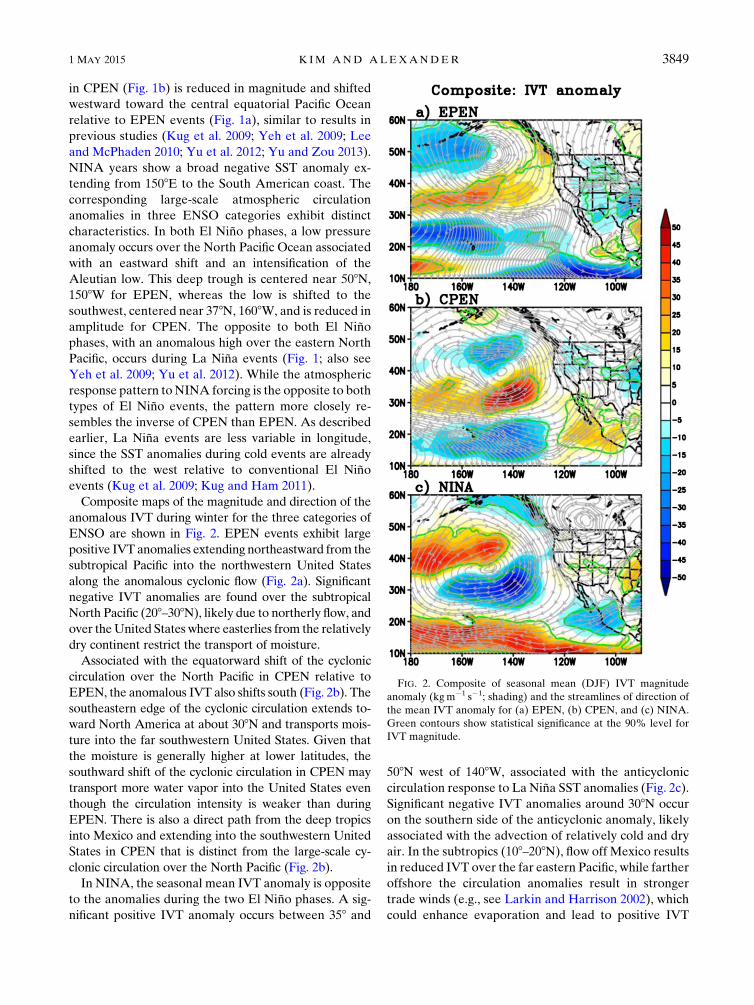
Composite maps of the magnitude and direction of the
anomalous IVT during winter for the three categories of
ENSO are shown in Fig. 2. EPEN events exhibit large
positive IVT anomalies extending northeastward from the
subtropical Pacific into the northwestern United States
along the anomalous cyclonic flow (Fig. 2a). Significant
negative IVT anomalies are found over the subtropical
North Pacific (208–308N), likely due to northerly flow, and
over theUnited States where easterlies from the relatively
dry continent restrict the transport of moisture.
Associated with the equatorward shift of the cyclonic
circulation over the North Pacific in CPEN relative to
EPEN, the anomalous IVT also shifts south (Fig. 2b). The
southeastern edge of the cyclonic circulation extends to-
ward North America at about 308N and transports mois-
ture into the far southwestern United States. Given that
the moisture is generally higher at lower latitudes, the
southward shift of the cyclonic circulation in CPEN may
transport more water vapor into the United States even
though the circulation intensity is weaker than during
EPEN. There is also a direct path from the deep tropics
into Mexico and extending into the southwestern United
States in CPEN that is distinct from the large-scale cy-
clonic circulation over the North Pacific (Fig. 2b).
In NINA, the seasonal mean IVT anomaly is opposite
to the anomalies during the two El Niño phases. A sig-nificant positive IVT anomaly occurs between 358 and
508N west of 1408W, associated with the anticyclonic
circulation response to La Niña SST anomalies (Fig. 2c).Significant negative IVT anomalies around 308N occur
on the southern side of the anticyclonic anomaly, likely
associated with the advection of relatively cold and dry
air. In the subtropics (108–208N), flow off Mexico results
in reduced IVT over the far eastern Pacific, while farther
offshore the circulation anomalies result in stronger
trade winds (e.g., see Larkin and Harrison 2002), which
could enhance evaporation and lead to positive IVT
FIG. 2. Composite of seasonal mean (DJF) IVT magnitude
anomaly (kgm21 s21; shading) and the streamlines of direction of
the mean IVT anomaly for (a) EPEN, (b) CPEN, and (c) NINA.
Green contours show statistical significance at the 90% level for
IVT magnitude.
1 MAY 2015 K IM AND ALEXANDER 3849

anomalies. Weak positive IVT anomalies occur over
most of the western United States associated with
northerly flow.
The land-only precipitation anomalies during the
three ENSO categories are shown in Fig. 3. The north-
westernUnited States and southwestern Canada (region
A: 408–588N, 1308–1208W; precipitation averaged only
over land within the purple box in Fig. 3) experience
enhanced precipitation relative to climatology in EPEN,
but reduced precipitation in CPEN (Fig. 3b), which is
consistent with the results from Yu and Zou (2013).
However, the enhanced precipitation in region A for
EPEN mainly results from two super El Niños (1982/83and 1997/98), while the moderate El Niño cases (1986/87and 2009/10) are near normal (Yu and Zou 2013), as
discussed further in section 5. During NINA events,
the precipitation in region A is slightly above normal
(Fig. 3c). The precipitation anomaly is 0.81mmday21 for
EPEN, 20.56mmday21 for CPEN, and 0.24mmday21
for NINA in regionA (Fig. 4). The positive precipitation
anomaly averaged over the southwestern United States
(region B: 208–408N, 1228–1088W; black box in Fig. 3) is
the greatest for CPEN among the ENSO categories with
values of 0.18mmday21 for EPEN, 0.47mmday21 for
CPEN, and 20.31mmday21 for NINA (Fig. 4). For
CPEN, the precipitation anomaly is positive over Cal-
ifornia, Arizona, and Mexico, where the IVT anomaly is
also positive. In EPEN, the precipitation anomaly is
slightly positive in region B despite a negative IVT
anomaly. However, while IVT is critical for bringing
moisture to the western United States in winter, pre-
cipitation is directly related to moisture flux convergence
($ � IVT).
4. Modulation of 6-h IVT and height variability byENSO
Next, we investigate the characteristics of IVT vari-
ability based on anomalies obtained by subtracting the
long-term (1979–2010) monthly mean from the in-
stantaneous 6-h values during DJF. The IVT variance
over the full record exhibits a zonal band of enhanced
variance in central North Pacific with a domainmaximum
at approximately 328N, 1808 that extends toward the
northwestern United States (Fig. 5a). The high variance
primarily results from the passage of midlatitude cyclones
(see, e.g., Newman et al. 2012) and their alternating re-
gions of enhanced (reduced) moisture transport on the
eastern (western) side of cold fronts. Figures 5b–d show
the 6-h IVT variance in each ENSO category divided by
the total variance (Fig. 5a), where the significance of the
change in the ENSO–total variance ratio is evaluated
using an F test and only significant values are shaded. The
FIG. 3. Composite of seasonal mean (DJF) precipitation anomaly
(mmday21) averaged only over the land areawithin the purple (region
A) andblack (regionB)boxes for (a)EPEN, (b)CPEN, and (c)NINA.
Aqua contours show statistical significance at the 90% level.
3850 JOURNAL OF CL IMATE VOLUME 28

IVT variability differs between the three ENSO cate-
gories. Relative to the total variance, the variance during
EPEN (Fig. 5b) is greater over central Mexico (green/
blue shading) and smaller over the subtropics and the
western half of theUnited States. For CPEN (Fig. 5c), the
variability is stronger over most of Mexico and the adja-
cent Pacific Ocean. The CPEN IVT variance is reduced
over much of the North Pacific west of about 1208Wwith
the exception of a narrow band that extends from ap-
proximately 258N, 1808 to the Washington coast (;478N,
1248W). During NINA winters the variance is enhanced
around 408N over the central North Pacific Ocean and
reduced across the all longitudes from approximately 208to 308N (Fig. 5d). The variability is also slightly greater
(weaker) over portions of the southwestern (northwestern)
United States.
We analyze the leading patterns of 6-h IVT variability
and associated 500-hPa height anomalies based on em-
pirical orthogonal function (EOF) analysis that is ap-
plied to 6-h IVT anomalies for the total period and for
each of three ENSO categories. Given the wide range in
IVT variability as a function of location, (e.g., it is much
greater over the ocean than over land), we first nor-
malize the anomalies by dividing them by the local
standard deviation of the total 6-h IVT before comput-
ing the EOFs. We note that the eigenvectors (EOF
patterns) are nearly identical between ENSO phases if
the EOF analysis is performed using nonnormalized
IVT anomalies (not shown). To emphasize the high IVT
variability over western North America, we also com-
puted EOFs using IVT values only over land. While this
raises the percent variance explained by the leading
EOFs and enhances the anomaly magnitude in specific
geographic locations (Alexander et al. 2015), the pat-
terns are not clearly distinguishable between the three
ENSO phases (not shown).
The leading EOF for the full period and the three
ENSOphases (Fig. 6) explains approximately 10% of the
variance for EPEN and NINA, approximately 15% for
CPEN, and approximately 12% for neutral years. The
percentage variance explained is relatively low, since we
use the 6-hourly anomalies with the biggest amplitude
over the ocean, leading to patterns that are not tightly tied
to specific geographic locations.While the state of ENSO
influences the location and strength of winter storms and
the large-scale moisture field, the overall IVT variability
is still dominated by internal atmospheric processes as-
sociated with moving extratropical cyclones.
The second mode explains only a small amount of
variance and is not distinguishable from the lower-order
EOFs; therefore, we will only focus on the first mode.
For the neutral years (Fig. 6a), the leading eigenvector is
characterized by anomalies of one sign (positive for this
phase of the EOF) that extends northeastward from the
Hawaiian Islands to the southwestern United States,
with a maximum over the far eastern Pacific. There is a
much weaker anomaly of the opposite sign to the north-
west. While the EOF by itself does not convey the sign
and magnitude of the pattern associated with the EOF,
the principal component (PC) does. The probability dis-
tribution of the leading PC (the time series of the phase
and amplitude of the corresponding EOF), as indicated
by a histogram of the first PC (PC1) values, is shown in
Fig. 7. The distribution of PC1 for the neutral period is
FIG. 4. Seasonalmean (DJF) precipitation anomaly (mmday21) averaged over regionsA andB
for EPEN (solid bar), CPEN (vertical stripe), and NINA (stippled bar).
1 MAY 2015 K IM AND ALEXANDER 3851

positively skewed (skewness is 0.69), indicating that very
large positive IVT anomalies are more common than
large negative values over the southwestern United
States.
For EPEN, the first EOF (EOF1) pattern is similar to
that in the neutral years, but the maximum is shifted to
the north and west near 358N, 1358W, and higher values
extend into the northwestern rather than the southwest-
ern United States (Fig. 6b). Anomalies of the opposite
sign are found over the northwestern and southeastern
corners of the domain. While the skewness of PC1 for
EPEN is smaller than in the other ENSOphases, it is still
positively skewed (skewness is 0.16), indicating that
large positive IVT anomalies extending from the sub-
tropical Pacific to the western United States are more
common than large negative values in this region (Fig. 7).
The EOF1 IVT pattern during CPEN has a pronounced
dipole with a northern band that extends from the sub-
tropics to the northwestern United States and a southern
center located in the vicinity of Baja California (Fig. 6c).
PC1 is positively skewed (Fig. 7; skewness is 0.26), in-
dicating that large positive values are more common over
Mexico and the southern United States than large
negative values. For NINA, the EOF1 of IVT also
exhibits a dipole with one center over California, Ari-
zona, and NewMexico, and the opposite sign anomalies
extending over the North Pacific Ocean from approxi-
mately 308N, 1708W to 508N, 1408W. The NINA PC1
values are also positively skewed (skewness is 0.21).
The IVT and 500-hPa height anomalies are examined
using composite analysis of 6-hourly databased on the
leading PC obtained from different ENSO phases. The
composite averages are computed using the non-
normalized values at the times when PC1 is greater than
positive two standard deviations for each of the ENSO
phases. The IVT and Z500 anomaly composites are
shown in Fig. 8. In neutral years (Fig. 8a), the composite
IVT anomaly patterns are similar to the corresponding
leading EOF, where the low pressure center is located
just off the coast of California with a maximum around
388N, 1408W. This trough exhibits a southwest–northeast
tilt and the associated cyclonic circulation transports
moisture from the subtropics to Baja California to nearly
all of the U.S. West Coast.
Unlike the other periods, the moisture source appears
to be primarily extratropical for EPEN (Fig. 8b), with a
FIG. 5. (a) Total variance of the IVT computed by 6-h values during DJF from 1979 to 2010 and the ratio of
variance for the 6-hourly IVT between (b) EPEN, (c) CPEN, and (d) NINA and the total variance. Shaded area
indicates where the ratio of variance is statistically significant at the 99% level by an F test.
3852 JOURNAL OF CL IMATE VOLUME 28

positive IVT anomaly extending from approximately
308N, 1608W in the Pacific to the northwesternU.S. coast.
The anomalous height pattern exhibits a very deep zon-
ally elongated trough centered at approximately 418N,
1558W, with a strong gradient along the eastern edge of
the trough that parallels the northwestern U.S. coast,
which is similar to the seasonal mean EPEN pattern
(Fig. 1a). The strong low pressure anomaly induces strong
moisture transport from the North Pacific toward the
northwestern United States with large amount of trans-
port into coastal Oregon but a modest amount on inland
penetration of moisture (Fig. 8b). In EPEN winter, this
circulation pattern occurs frequently and thus could re-
sult in enhanced seasonal precipitation in the north-
western United States (Fig. 3a).
For CPEN, a large positive IVT anomaly extends from
the subtropical eastern Pacific Ocean across Baja Cal-
ifornia and Mexico and into the southwestern United
States (Fig. 8c). The associated low pressure anomaly is
shifted southeastward compared to EPEN and is located
just off the California coast, where the cyclonic circula-
tion induces a large amount of water vapor transport into
the southwestern United States. The strong negative IVT
anomaly over the northeastern PacificOcean is found along
the strong gradient between the ridge centered at approxi-
mately 508N, 1408W and a trough centered at approxi-
mately 308N, 1258W, where the associated northeasterly
FIG. 6. Eigenvectors of the first EOFmode for 6-hourly IVT anomaly for (a) neutral years, (b) EPEN, (c) CPEN,
and (d) NINA. Numbers indicate the percentage of variance of 6-hourly IVT anomalies in each ENSO phases. IVT
anomalies are normalized by the total IVT daily standard deviation.
FIG. 7. Probability of EOF PC1 normalized value for neutral
(black), EPEN (red), CPEN (green), and NINA (blue) phases.
Numbers in parentheses indicate the skewness of the probability
for each phase.
1 MAY 2015 K IM AND ALEXANDER 3853

flow transports colder/dryer air, some coming from
North America, over the Pacific Ocean. Frequent oc-
currence of this pattern would result in heavy seasonal
precipitation over the southwestern United States and a
deficit in the northwestern United States and British
Columbia (Fig. 3b).
For NINA, the dominant anomalous circulation is
distinctly different from the patterns during both El
Niño phases and the neutral years (Fig. 8d). For NINA,
there are two high pressure anomalies, one over the
southern United States and one over the North Pacific
Ocean, with low pressure anomalies over the subtropics
and northwestern United States. Moisture enters the
southwestern United States via the anticyclonic circu-
lation on the far western side of the ridge centered over
Texas. The flow associated with the strong anticyclone
over the North Pacific and cyclonic anomaly over the
Pacific Northwest transports relatively cold/dry air from
higher latitudes resulting in negative IVT anomalies
from Canada to the central Pacific.
5. Summary and discussion
The change in the location and sign of SST anomalies
in the tropical Pacific Ocean associated with different
phases of ENSO alter the large-scale atmospheric state,
and thus have different impacts on the climate over the
Pacific–North American region. In this study, we in-
vestigate how the three phases of ENSO (i.e., eastern
Pacific and central Pacific El Niños as well as La Niña;EPEN, CPEN, and NINA, respectively) modulate theatmospheric circulation and thereby change the watervapor transport into western North America.In EPEN, large positive seasonal IVT anomalies ex-
tend northeastward from the subtropical Pacific into the
northwestern United States following the anomalous
FIG. 8. EOF PC-based composites of 6-h 500-hPa height (m; contour interval is 30m) and IVT (kgm21 s21;
shading) anomalies associated with the leading IVT EOF modes in each ENSO phase: (a) neutral, (b) EPEN,
(c) CPEN, and (d) NINA.
3854 JOURNAL OF CL IMATE VOLUME 28
cyclonic flow around an anomalously deepAleutian low.
In CPEN, a southward shift of the cyclonic circulation
over the North Pacific, which extends toward California,
induces moisture transport into the southwestern United
States. There is also a second IVT pathway into North
America during CPEN; that is, moisture from the eastern
tropical Pacific is transported acrossMexico and into the
southwestern United States. For NINA, the opposite
circulation arises with an anticyclonic anomaly over the
North Pacific and significant negative IVT anomalies
at approximately 308N on the southern side of this
anticyclone.
The characteristics of the 6-h IVT anomalies during
different ENSO phases have been explored by EOF and
composite analyses. For EPEN, anomalous height pat-
tern exhibits a very deep zonally elongated trough cen-
tered at approximately 408N, 1508W, which induces
strong moisture transport from the North Pacific to the
northwestern U.S. coast but with a modest amount on
inland penetration of moisture. For CPEN, the low
pressure anomaly is shifted southeastward compared to
EPEN and is located just off the California coast, where
the cyclonic circulation induces a large amount of water
vapor transport into the southwestern United States.
For NINA, moisture enters the southwestern United
States via anticyclonic circulation.
The water vapor transport associated with ARs is
responsible for heavy snowfall and flooding events in
western NorthAmerica during winter. It is also themain
source of water for the western United States (Ralph
and Dettinger 2011), providing 25%–50% of Cal-
ifornia’s water supply (Guan et al. 2013; Dettinger et al.
2011). A recent study by Alexander et al. (2015) found
that duringwinter, moist air parcels from the Pacific take
distinct pathways through gaps in the Cascades, Sierra
Nevada, and peninsular mountains of Baja California,
leading to extreme precipitation events in the U.S. In-
termountain West. Our results indicate that CPEN
events may enhance heavy precipitation in the south-
western states such as Arizona and NewMexico, but the
overall influence of ENSO on the moisture transport
into the U.S. Intermountain West and its predictability
should be explored in greater detail.
In this study, we have used a high-resolution re-
analysis that began in 1979, which includes satellite data.
While this greatly improves the representation of ARs
and IVT relative to coarse-resolution but longer re-
analyses, it limits the composite analyses to just four
cases for each ENSO phase. In addition, ENSO-related
precipitation anomalies vary widely from episode to ep-
isode (e.g., Ropelewski and Halpert 1987). For example,
the western United States was extremely dry during the
1976/77 El Niño but anomalously wet during the strong
1982/83 and 1997/98 El Niño events. Thus, the impact ofvariations in ENSO on water vapor transport and pre-cipitation over the Pacific–NorthAmerican region should
be investigated further using longer datasets, where
possible, and by model experiments.
Acknowledgments. The constructive and valuable
comments of two reviewers are greatly appreciated. Kim
was supported by the Korea Meteorological Administra-
tion Research and Development Program under Grant
APCC2013-3141.Alexanderwas supported by grants from
the Bureau of Reclamation. We thank James D. Scott for
providing the IVT data and Drs. Kathy Pegion (GMU)
and Klaus Wolter (NOAA/ESRL) for their insightful
suggestions.
REFERENCES
Adler, R. F., andCoauthors, 2003: The version 2Global Precipitation
Climatology Project (GPCP) monthly precipitation analysis
(1979–present). J. Hydrometeor., 4, 1147–1167, doi:10.1175/
1525-7541(2003)004,1147:TVGPCP.2.0.CO;2.
Alexander, M. A., J. D. Scott, D. Swales, M. Hughes, K. Mahoney,
J. J. Barsugli, and C. Smith, 2015: Moisture pathways into
the U.S. Intermountain West associated with heavy
winter precipitation events. J. Hydrometeor., doi:10.1175/
JHM-D-14-0139.1, in press.
Ashok, K., S. K. Behera, S. A. Rao, H. Weng, and T. Yamagata,
2007: El Niño Modoki and its possible teleconnection.J. Geophys. Res., 112, C11007, doi:10.1029/2006JC003798.
Bao, J.-W., S. A. Michelson, P. J. Neiman, F. M. Ralph, and J. M.
Wilczak, 2006: Interpretation of enhanced integrated water
vapor bands associated with extratropical cyclones: Their
formation and connection to tropical moisture. Mon. Wea.
Rev., 134, 1063–1080, doi:10.1175/MWR3123.1.
Barsugli, J. J., and P. Sardeshmukh, 2002: Global atmospheric
sensitivity to tropical SST anomalies throughout the Indo-
Pacific basin. J. Climate, 15, 3427–3442, doi:10.1175/
1520-0442(2002)015,3427:GASTTS.2.0.CO;2.
Capotondi, A., and Coauthors, 2015: Understanding ENSO diversity.
Bull. Amer. Meteor. Soc., doi:10.1175/BAMS-D-13-00117.1, in
press.
Dettinger, M. D., 2004: Fifty-two years of ‘‘pineapple-express’’
storms across the west coast of North America, PIER Energy-
Related Environ. Res. Rep. CEC-500–2005-004, 15 pp.
——, F. M. Ralph, T. Das, P. J. Neiman, and D. R. Cayan, 2011:
Atmospheric rivers, floods, and the water resources of Cal-
ifornia. Water, 3, 445–478, doi:10.3390/w3020445.
Guan, B., D. E.Waliser, N. P.Molotch, E. J. Fetzer, and P. J. Neiman,
2012: Does the Madden–Julian oscillation influence wintertime
atmospheric rivers and snowpack in the Sierra Nevada? Mon.
Wea. Rev., 140, 325–342, doi:10.1175/MWR-D-11-00087.1.
——, N. P. Molotch, D. E. Waliser, E. J. Fetzer, and P. J. Neiman,
2013: The 2010/2011 snow season in California’s Sierra Ne-
vada: Role of atmospheric rivers and modes of large-scale
variability. Water Resour. Res., 49, 6731–6743, doi:10.1002/
wrcr.20537.
Jiang, T., and Y. Deng, 2011: Downstream modulation of North
Pacific atmospheric river activity by East Asian cold surges.
Geophys. Res. Lett., 38, L20807, doi:10.1029/2011GL049462.
1 MAY 2015 K IM AND ALEXANDER 3855
——, K. J. Evans, Y. Deng, and X. Dong, 2014: Intermediate fre-
quency atmospheric disturbances: A dynamical bridge connect-
ing western U.S. extreme precipitation with East Asian cold
surges. J. Geophys. Res. Atmos., 119, 3723–3735, doi:10.1002/2013JD021209.
Johnson, N. C., 2013: Howmany ENSO flavors can we distinguish?
J. Climate, 26, 4816–4827, doi:10.1175/JCLI-D-12-00649.1.
Kao, H.-Y., and J.-Y. Yu, 2009: Contrasting eastern-Pacific and
central-Pacific types of ENSO. J. Climate, 22, 615–632,
doi:10.1175/2008JCLI2309.1.
Kug, J.-S., and Y.-G. Ham, 2011: Are there two types of La Niñaevents? Geophys. Res. Lett., 38, L16704, doi:10.1029/
2011GL048237.
——, F.-F. Jin, and S.-I. An, 2009: Two types of El Niño events:Cold tongue El Niño and warm pool El Niño. J. Climate, 22,1499–1515, doi:10.1175/2008JCLI2624.1.
Lackmann, G. M., and J. R. Gyakum, 1999: Heavy cold-season pre-
cipitation in the northwestern United States: Synoptic climatol-
ogy and an analysis of the flood of 17–18 January 1986. Wea.
Forecasting, 14, 687–700, doi:10.1175/1520-0434(1999)014,0687:
HCSPIT.2.0.CO;2.
Larkin, N. K., andD. E. Harrison, 2002: ENSOwarm (El Niño) andcold (La Niña) event life cycles: Ocean surface anomalypatterns, their symmetries, asymmetries, and implications.J. Climate, 15, 1118–1140, doi:10.1175/1520-0442(2002)015,1118:
EWENOA.2.0.CO;2.
Lee, T., and M. J. McPhaden, 2010: Increasing intensity of El Niñoin the central-equatorial Pacific. Geophys. Res. Lett., 37,
L14603, doi:10.1029/2010GL044007.
Madden, R. A., and P. R. Julian, 1972: Description of global-scale
circulation cells in the tropics with a 40–50 day period. J. Atmos.
Sci., 29, 1109–1123, doi:10.1175/1520-0469(1972)029,1109:
DOGSCC.2.0.CO;2.
Mo, K., 2010: Interdecadal modulation of the impact of ENSO on
precipitation and temperature over theUnited States. J. Climate,
23, 3639–3656, doi:10.1175/2010JCLI3553.1.
Neiman, P. J., F. M. Ralph, G. A. Wick, J. D. Lundquist, andM. D.
Dettinger, 2008: Meteorological characteristics and overland
precipitation impacts of atmospheric rivers affecting the
West Coast of North America based on eight years of SSM/I
satellite observations. J. Hydrometeor., 9, 22–47, doi:10.1175/2007JHM855.1.
——, L. J. Schick, F. M. Ralph, M. Hughes, and G. A. Wick, 2011:
Flooding in western Washington: The connection to atmo-
spheric rivers. J. Hydrometeor., 12, 1337–1358, doi:10.1175/
2011JHM1358.1.
Newell, R. E., N. E. Newell, Y. Zhu, and C. Scott, 1992: Tropo-
spheric rivers? A pilot study. Geophys. Res. Lett., 19, 2401–
2404, doi:10.1029/92GL02916.
Newman, M., M. A. Alexander, and J. D. Scott, 2011a: An em-
pirical model of tropical ocean dynamics. Climate Dyn., 37,
1823–1841, doi:10.1007/s00382-011-1034-0.
——, S.-I. Shin, and M. A. Alexander, 2011b: Natural variation in
ENSO flavors. Geophys. Res. Lett., 38, L14705, doi:10.1029/
2011GL047658.
——, G. N. Kiladis, K. M. Weickmann, F. M. Ralph, and P. D.
Sardeshmukh, 2012: Relative contributions of synoptic and
low-frequency eddies to time-mean atmospheric moisture
transport, including the role of atmospheric rivers. J. Climate,
25, 7341–7361, doi:10.1175/JCLI-D-11-00665.1.
Ralph, F. M., and M. D. Dettinger, 2011: Storms, floods and the
science of atmospheric rivers. Eos, Trans. Amer. Geophys.
Union, 92, 265–266, doi:10.1029/2011EO320001.
——, P. J. Neiman, G. A. Wick, S. I. Gutman, M. D. Dettinger,
D. R. Cayan, and A. B. White, 2006: Flooding on California’s
Russian River: Role of atmospheric rivers. Geophys. Res.
Lett., 33, L13801, doi:10.1029/2006GL026689.
Reynolds, R. W., N. A. Rayner, T. M. Smith, D. C. Stokes, and
W. Wang, 2002: An improved in situ and satellite SST anal-
ysis for climate. J. Climate, 15, 1609–1625, doi:10.1175/
1520-0442(2002)015,1609:AIISAS.2.0.CO;2.
Ropelewski, C. F., and M. S. Halpert, 1987: Global and regional
scale precipitation patterns associated with the El Niño/SouthernOscillation. Mon. Wea. Rev., 115, 1606–1626, doi:10.1175/
1520-0493(1987)115,1606:GARSPP.2.0.CO;2.
Rutz, J. J., W. J. Steenburgh, and F.M. Ralph, 2014: Climatological
characteristics of atmospheric rivers and their inland pene-
tration over the western United States. Mon. Wea. Rev., 142,905–921, doi:10.1175/MWR-D-13-00168.1.
Saha, S., and Coauthors, 2010: The NCEP Climate Forecast System
Reanalysis.Bull. Amer.Meteor. Soc., 91, 1015–1057, doi:10.1175/2010BAMS3001.1.
vanOldenborgh, G. J., andG. Burgers, 2005: Searching for decadal
variations in ENSO precipitation teleconnections. Geophys.
Res. Lett., 32, L15701, doi:10.1029/2005GL023110.
Waliser, D. E., B. Guan, J.-L. Li, and J. Kim, 2012: Addendum to
‘‘Simulating cold season snowpack: Impacts of snow albedo
and multi-layer snow physics’’: Waliser, D., J. Kim, Y. Xue,
Y. Chao, A. Eldering, R. Fovell, A. Hall, Q. Li, K. N. Liou,
J. McWilliams, S. Kapnick, R. Vasic, F. De Sale, and Y. Yu
(2011), Climatic Change, 109 (Suppl 1): S95–S117, doi:10.1007/
s10584-011-0312-5. Climate Change, 114, 399–400, doi:10.1007/s10584-012-0531-4.
Warner, M. D., C. F. Mass, and E. P. Salathé, 2012: Wintertime
extreme precipitation events along the Pacific Northwest
coast: Climatology and synoptic evolution. Mon. Wea. Rev.,
140, 2021–2043, doi:10.1175/MWR-D-11-00197.1.
Yeh, S.-W., J. S. Kug, B. Dewitte, M.-H. Kwon, B. Kirtman, and
F.-F. Jin, 2009: Recent changes in El Niño and its projectionunder global warming. Nature, 461, 511–515, doi:10.1038/
nature08316.
Yu, J.-Y., andY. Zou, 2013: The enhanced drying effect of Central-
Pacific El Niño on US winter. Environ. Res. Lett., 8, 014019,doi:10.1088/1748-9326/8/1/014019.
——, ——, S. T. Kim, and T. Lee, 2012: The changing impact of El
Niño on US winter temperatures. Geophys. Res. Lett., 39,
L15702, doi:10.1029/2012GL052483.
Zhu, Y., and R. Newell, 1998: A proposed algorithm for moisture
fluxes from atmospheric rivers.Mon. Wea. Rev., 126, 725–735,
doi:10.1175/1520-0493(1998)126,0725:APAFMF.2.0.CO;2.
3856 JOURNAL OF CL IMATE VOLUME 28
Recommended