INTERNATIONAL HYDROGRAPHIC ORGANIZATION
ELECTRONIC NAVIGATIONAL CHARTS
(ENCs)
“PRODUCTION, MAINTENANCE AND
DISTRIBUTION GUIDANCE”
A guide to the requirements and processes necessary
to produce, maintain and distribute ENCs
Publication S-65
Edition 2.0.0, April 2012
The International Hydrographic Bureau acknowledges the assistance of the United
Kingdom Hydrographic Office in the preparation of this publication.
© Copyright International Hydrographic Organization [2012]
This work is copyright. Apart from any use permitted in accordance with the Berne Convention for the Protection of Literary and Artistic Works (1886), and except in the circumstances described below, no part may be translated, reproduced by any process, adapted, communicated or commercially exploited without prior written permission from the International Hydrographic Bureau (IHB). Copyright in some of the material in this publication may be owned by another party and permission for the translation and/or reproduction of that material must be obtained from the owner.
This document or partial material from this document may be translated, reproduced or distributed for general information, on no more than a cost recovery basis. Copies may not be sold or distributed for profit or gain without prior written agreement of the IHB and any other copyright holders.
In the event that this document or partial material from this document is reproduced, translated or distributed under the terms described above, the following statements are to be included:
“Material from IHO publication [reference to extract: Title, Edition] is reproduced with the permission of the International Hydrographic Bureau (IHB) (Permission No ……./…) acting for the International Hydrographic Organization (IHO), which does not accept responsibility for the correctness of the material as reproduced: in case of doubt, the IHO’s authentic text shall prevail. The incorporation of material sourced from IHO shall not be construed as constituting an endorsement by IHO of this product.”
“This [document/publication] is a translation of IHO [document/publication] [name]. The IHO has not checked this translation and therefore takes no responsibility for its accuracy. In case of doubt the source version of [name] in [language] should be consulted.”
The IHO Logo or other identifiers shall not be used in any derived product without prior written permission from the IHB.
i
CONTENTS
Introduction ........................................................................................ 1
What is an ENC? .................................................................................. 3
Hydrographic Office Responsibilities For Producing ENCs ................... 4
ENC Production and Distribution Guidance…………………………………….7
STAGE 1 – Design Production Process ............................................... 7
STEP 1 – Production Method .............................................................. 7
STEP 2 – A Quality System ................................................................ 8
STAGE 2 – Define ENC Production Requirement ................................. 9
STEP 1 – Identify Requirements ......................................................... 9
STEP 2 – Produce Production Plan ....................................................... 9
STAGE 3 – Acquire Production System ............................................. 13
STEP 1 – Identify Requirement ......................................................... 13
STEP 2 – Invitation to Tender .......................................................... 13
STEP 3 – System Installation and Testing .......................................... 13
STEP 4 – Live Running .................................................................... 13
STAGE 4 – Obtain and Train Staff ..................................................... 14
STEP 1 – Staffing Levels .................................................................. 14
STEP 2 – Determine Skill Levels ....................................................... 14
STEP 3 – Identify Training Provider ................................................... 15
STAGE 5 – Prepare Specifications for Data Capture ......................... 16
STEP 1 – Published Specifications ..................................................... 16
STEP 2 – Data Capture and Product Specifications .............................. 16
STAGE 6 – Capture Data for New Cells ............................................. 17
STEP 1 – Optionally, place external capture contract ........................... 17
STEP 2 – Capture data .................................................................... 17
STAGE 7 – Edge Match Data ............................................................. 18
STEP 1 –National data ..................................................................... 18
STEP 2 – Between Nations ............................................................... 18
STAGE 8 – Verify and Validate Data ................................................. 20
STEP 1 – Production Systems and Procedures .................................... 20
STEP 2 – Verification ...................................................................... 20
STEP 3 – Validation ........................................................................ 20
STAGE 9 – Maintain ENCs ................................................................. 21
STEP 1 – Establish mechanism for ENC updating ................................. 21
ii
STEP 2 – Notice to Mariners (Updates) .............................................. 21
STEP 3 – New Editions or Notice to Mariners (NM) Blocks ..................... 21
STEP 4 – ENC Re-issues .................................................................. 21
STEP 5 – Distribution of ENC Data .................................................... 22
STAGE 10 – Distribute ENC Data ........................................................ 23
STEP 1 – Identify Distribution Mechanism .......................................... 23
STEP 2 – Sign Agreement ................................................................ 25
STEP 3 – Distribution Format ........................................................... 25
Glossary of Terms ............................................................................. 27
Introduction
Purpose and Scope
This document provides a high level guide to the production,
maintenance and distribution of Electronic Navigational Charts (ENCs).
It offers a framework to inform hydrographic offices of the processes
and requirements necessary to produce, maintain and distribute ENCs.
It provides references to documentation which can support each stage
of the process. It is not intended to serve as a technical reference
manual but to enable hydrographic offices to gain an overview of ENC
production processes, and the requirements and procedures that need to
be in place to set up an ENC production facility.
References
Standards and Conventions
A IHO S-52, “Specifications for Chart Content and Display Aspects of ECDIS”
B IHO S-57, “IHO Transfer Standard for Digital Hydrographic Data”
C IHO S-58, “Recommended ENC Validation Checks”
D IHO S-62, “ENC Producer Codes”
E IHO S-63, “IHO Data Protection Scheme”
F IHO M-3, “Resolutions of the IHO”, Resolution 1/1997, Principles of
the Worldwide Electronic Navigational Chart Database (WEND).
G IHO S-4, “Regulations of the IHO for International (INT) Charts and
Chart Specifications of the IHO”
H IHO S-8, FIG/IHO/ICA „Standards of Competence for Nautical
Cartographers‟
I IMO Resolutions MSC.232 (82) and A.817 (19), as amended by
MSC.64 (67) and MSC.86 (70), “Performance Standards for
Electronic Chart Display and Information Systems (ECDIS)”
J IMO Convention on the Safety of Life at Sea (SOLAS), 2009
K IHO S-66, “Facts about electronic charts and carriage requirements”
Indicative Documentation
L UKHO ENC Product Specification
M UKHO ENC Data Capture Specification
N UKHO ENC Training Documentation and Job Descriptions
O UKHO Quality Procedures for the production of ENCs
P Guidelines for the Implementation of the WEND Principles
The UKHO can make References L & M and the overview elements of References N & O available on request;
due to their complexity more detailed elements of the latter pair would typically form part of the
documentation provided as part of an overall training/support package and would be considered on an individual basis.
In addition, various HOs have established their own specifications; certain of them are available.
2
Abbreviations
ENC Electronic Navigational Chart
ECDIS Electronic Chart Display and Information System
HO Hydrographic Office
IHO International Hydrographic Organization
IMO International Maritime Organization
QMS Quality Management System
RENC Regional ENC Coordinating Centre
SOLAS Convention on the Safety of Life at Sea
WEND Worldwide ENC Database
3
What is an ENC?
Digitised Data
Electronic Navigational Charts (ENCs) consist of digitised data conforming to
the IHO‟s S-57 ENC Product Specification that records all the relevant charted
features necessary for safe navigation, such as coastlines, bathymetry, buoys, lights, etc. The basic unit of geographic coverage (analogous to a paper chart)
is termed a cell.
An Electronic Chart Display and Information System (ECDIS) will convert the
ENC and its updates into its own native System ENC (SENC) format. The SENC
format is optimised by the ECDIS manufacture for the correct and efficient display of the ENC information.
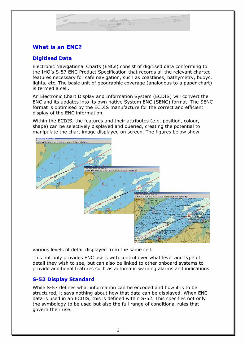
Within the ECDIS, the features and their attributes (e.g. position, colour,
shape) can be selectively displayed and queried, creating the potential to
manipulate the chart image displayed on screen. The figures below show
various levels of detail displayed from the same cell:
This not only provides ENC users with control over what level and type of
detail they wish to see, but can also be linked to other onboard systems to
provide additional features such as automatic warning alarms and indications.
S-52 Display Standard
While S-57 defines what information can be encoded and how it is to be structured, it says nothing about how that data can be displayed. When ENC
data is used in an ECDIS, this is defined within S-52. This specifies not only
the symbology to be used but also the full range of conditional rules that
govern their use.
4
Official Vector Charts
ENCs are official vector-based electronic charts designed to meet the relevant chart carriage requirements of the Safety of Life At Sea (SOLAS) convention.
When displayed within certain parameters, and using a type approved ECDIS,
ENCs fully satisfy SOLAS chart carriage requirements, and so can be used as
the primary means of navigation.
Relevant Regulations
The SOLAS convention of the International Maritime Organization (IMO) includes a number of pertinent requirements:
That nations publish nautical information necessary for safe navigation;
this includes systematic updating with all necessary safety-critical
information
That ships shall carry nautical charts and that use of an ECDIS meets this
requirement. It also notes that such charts (paper or electronic) shall be “issued by or on behalf of a Government authorized hydrographic office or
other relevant government institution”; in other words they must be
„official charts‟.
The IMO‟s ECDIS Performance Standard further mandates that “The chart
information to be used in ECDIS should be the latest edition of that originated by a government authorized hydrographic office, and conform to IHO
standards.”
In order to be a legal equivalent of paper charts, the ECDIS must be type-
approved in accordance with Standard 61174 of the International
Electrotechnical Commission (IEC).
Hydrographic Office Responsibilities For Producing ENCs
The responsibilities of Hydrographic Offices (HOs) for the production and
distribution of ENCs are defined in the WEND (Worldwide Electronic Navigational Chart Database) principles. (M-3, Resolutions of the IHO). These
note that :
“The purpose of WEND is to ensure a world-wide consistent level of
high-quality, updated official ENCs through integrated services that
support chart carriage requirements of SOLAS Chapter V, and the requirements of the IMO Performance Standards for ECDIS.”
HOs are responsible for:
The preparation and provision of digital data and its subsequent updating
for waters of national jurisdiction.
Ensuring that, mariners, anywhere in the world, can obtain fully updated
ENCs for all shipping routes and ports across the world and that their ENC data are available to users through integrated services.
Assuring the high quality of its ENC services through the use of a Quality
Management System that is certified by a relevant body as conforming to a
suitable recognised standard; typically this will be ISO 9001:2000.
5
Ensuring compliance with all relevant IHO and IMO standards and criteria (including IHO S-57, IHO S-52, or their replacements).
Providing timely updates to the ENC for the mariner; these should be at
least as frequent as those provided by the nation for correction of paper
charting.
Reference is made throughout this document to the relevant WEND principles that support some of the stages of the ENC production processes.
For full details of the WEND principles refer to M-3 - Resolutions of the IHO,
Resolution 1/1997, Principles of the Worldwide Electronic Navigational Chart
Database (WEND).
Note should also be taken of the 'Guidelines for the Implementation of the WEND Principles'1 agreed by the WEND Committee in 2008 and available on
the IHO Website.
Useful References: S-66 - Facts about electronic charts and carriage
requirements2; (Plus those documents listed above).
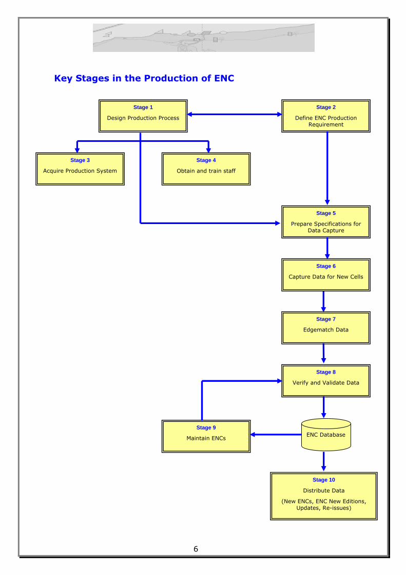
Flow Chart
A flow chart detailing each stage of the process is shown overleaf.
1 Reference P
2 Reference K
6
Key Stages in the Production of ENC
Stage 1
Design Production Process
Stage 3
Acquire Production System
Stage 4
Obtain and train staff
staff
Stage 2
Define ENC Production Requirement
Stage 5
Prepare Specifications for Data Capture
Stage 6
Capture Data for New Cells
Stage 7
Edgematch Data
Stage 9
Maintain ENCs
Stage 8
Verify and Validate Data
Stage 10
Distribute Data
(New ENCs, ENC New Editions, Updates, Re-issues)
ENC Database
7
ENC PRODUCTION AND DISTRIBUTION GUIDANCE
STAGE 1 – Design Production Process
SSTTEEPP 11 –– PPrroodduuccttiioonn MMeetthhoodd
Before the production process can be designed, it has to be decided which
source material will be used for the ENCs.
ENCs can be encoded directly from original survey material, databased
information, from existing paper charts or a combination of each.
The decision as to which source material will be used will depend on
several factors:
The quality and format (i.e. digital or analogue) of existing survey
data. For example it may be more efficient and prudent to produce
ENCs only from surveys completed to modern surveying standards.
The availability of accurate transformations for existing information to WGS-84 where required.
The existence of, or facilities to produce, rectified raster images of
existing charts.
Once it has been decided which source material will be used, a production
process needs to be designed and a Quality Management System (QMS) for ENC developed to interface with existing production processes.
Any production process will be dependent on whether the Data Capture is
to be carried out „in house‟ or under contract – see Stages 5 & 6. This
decision must be based on the in house production capacity, number of
cells to be captured, required timescales, available staff and IT resources, and funding. Each has its own advantages and disadvantages. These
include:
In house capture should provide a more flexible solution but may
require a longer lead time for staff training and may have resourcing
issues where a large team is needed for initial capture and a much smaller team to maintain the service thereafter.
Contracting out the work should reduce the costs of basic capture,
however the time necessary to put the contract in place should not be
underestimated nor the effort required to support it; also final
validation needs to be carried out by the HO taking responsibility for
the product.
Options such as using external resources to provide an initial „bulk load‟ -
see Stage 2 - with all further capture and maintenance carried out in-house
should be considered.
Consideration should be given to ensure that the publication of ENCs and
updates is co-incident with the publication of the equivalent paper chart information.
8
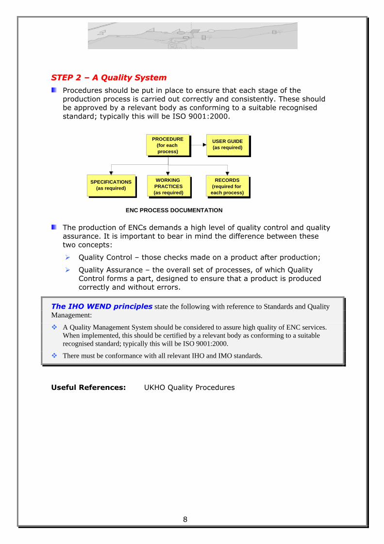
SSTTEEPP 22 –– AA QQuuaalliittyy SSyysstteemm
Procedures should be put in place to ensure that each stage of the production process is carried out correctly and consistently. These should
be approved by a relevant body as conforming to a suitable recognised
standard; typically this will be ISO 9001:2000.
The production of ENCs demands a high level of quality control and quality
assurance. It is important to bear in mind the difference between these two concepts:
Quality Control – those checks made on a product after production;
Quality Assurance – the overall set of processes, of which Quality
Control forms a part, designed to ensure that a product is produced
correctly and without errors.
The IHO WEND principles state the following with reference to Standards and Quality
Management:
A Quality Management System should be considered to assure high quality of ENC services.
When implemented, this should be certified by a relevant body as conforming to a suitable
recognised standard; typically this will be ISO 9001:2000.
There must be conformance with all relevant IHO and IMO standards.
Useful References: UKHO Quality Procedures
PROCEDURE
(for each
process)
SPECIFICATIONS
(as required)
WORKING
PRACTICES
(as required)
RECORDS
(required for
each process)
USER GUIDE
(as required)
ENC PROCESS DOCUMENTATION
9
STAGE 2 – Define ENC Production Requirement
SSTTEEPP 11 –– IIddeennttiiffyy RReeqquuiirreemmeennttss
While each nation has the responsibility for ENCs in its own waters, many
aspects of the overall service to the mariner will be improved through their
working within the relevant Regional Hydrographic Commission (RHC). This will expedite the completion of small scale coverage and the agreement of
cell boundaries between nations. The WEND Task Group recommended
that RHCs should:
Identify key shipping routes and ports within their regions
Identify charts covering these routes and ports to be captured as ENCs
Identify producer nations for the ENCs
Arrange for their production
Wherever possible ENCs should be based on INT charts and the producer
nations for the ENCs should be the same as the producer nations for the
corresponding INT charts.
If ENCs are to display correctly in an ECDIS it is especially important that
there is no overlap of data within the same navigational purpose band. The ENC Product Specification3 makes it clear that such overlap must not occur.
See also S-57 Appendix B.1, Annex A – Use of the Object Catalogue for
ENC, clause 2.1.8.
In addition to the agreement of boundaries, it is important that neighbouring countries agree, where possible, factors contributing to
consistent ENC data encoding such as assignment of ENCs to navigational
purpose, use of SCAMIN, and contour interval to provide a seamless depiction (see Stage 7, Step 2). The final assignment of ENCs to
navigational purposes and the values used for individual SCAMIN
attribution should preferably be done through consultation with all ENC
Producer States within a Regional Hydrographic Commission as
appropriate, in order to maintain consistency across national or regional boundaries.
SSTTEEPP 22 –– PPrroodduuccee PPrroodduuccttiioonn PPllaann
A national production plan then needs to be compiled to define:
which geographic areas are to be captured – note that this relates to
actual areas of data coverage rather than the rectangular cell limits.
which navigational purposes are to be populated for each area
how the areas are to be divided into cells for each navigational purpose
the order of capture; e.g. larger scale cells first
The production plan will be dependent on some of the following factors:
3 Reference B, Appendix B.1
10
The reason for the requirement – Defence / SOLAS
Priority given to major ports and traffic routes, based on volumes of
goods and number of passengers
Liaison with bordering countries to maximise production, improve
efficiency and coverage, and to ensure cross-border consistency
Design considerations outlined below.

11
The IHO WEND principles also state the following with reference to responsibility and
ownership.
SOLAS Chapter V, Regulation 9, requires Contracting Governments to ensure that
hydrographic data are available in a suitable manner in order to satisfy the needs of safe
navigation. Once the carriage of ECDIS becomes mandatory, there will be a consequential
requirement to ensure that such data, as agreed by IMO, are available in a form suitable for use
in ECDIS.
It is expected that Member States, for waters of national jurisdiction, will have mature supply
systems for ENCs and their subsequent updating in place by the earliest date for mandatory
carriage of ECDIS.
By the dates established by IMO , Member States will strive to either:
a Provide the necessary ENC coverage, or
b Agree with other States to produce the necessary ENC coverage on their behalf.
IHO will address overall coverage on a regional basis through Regional Hydrographic
Commissions.
The INT chart system is a useful basis for initial area selection for producing ENCs.
Responsibilities for providing digital data outside areas of national jurisdictions must be
established.
In producing ENCs, Member States are to take due account of the rights of the owners of
source data and if paper chart coverage has been published by another Member State, the rights
of that State.
Responsibility for the production of ENCs can be delegated in whole or in part by a country to
another country, which then becomes the producing country in the considered area.
When the limits of waters of national jurisdiction between two neighbouring countries are not
established, or it is more convenient to establish boundaries other than established national
boundaries, producing countries are to define the boundaries for ENC production within a
technical arrangement. These limits would be for cartographic convenience only and shall not
be construed as having any significance or status regarding political or other jurisdictional
boundaries.
In international waters, the INT chart producer nation shall be assumed to be the producer of
the corresponding ENC. Where the offshore limits of waters under national jurisdiction have
not yet been established, the clause above should apply.
In areas where the paper INT charts overlap, neighbouring producer nations should agree a
common limit of ENC production in the overlapping areas. Cartographic boundaries should be
as simple as possible, for example: a succession of straight segments and turning points
corresponding to such things as meridians, parallels, or chart limits. Where different producer
nations are responsible for INT coverage of the same area at different scales, those nations
should agree on a suitable set of boundaries so as to provide the user with the most coherent
service possible.
Useful Reference: Guidelines for the Implementation of the WEND
Principles
12
Cell Schema Design Considerations
LLiimmiittss ooff EENNCC CCeellllss
The HO has to decide how the limits of the planned ENC cells should be
defined. The limits can be based on the existing limits of paper charts, or
be defined by a rectangular grid.
The ENC Production Specification, S-57 Appendix B.1, states that “the
geographic extent of the cell must be chosen by the ENC producer to
ensure that the resulting dataset file contains no more than 5 megabytes
of data. Subject to this consideration, the cell size must not be too small in
order to avoid the creation of an excessive number of cells.”
It also states that “cells must be rectangular”. Within this, the actual data
coverage can be any shape.
CCoommppiillaattiioonn SSccaalleess
It is recommended that the compilation scales for ENCs are based upon
standard radar ranges as described in the Use of the Object Catalogue for
ENC, S-57 Appendix B.1, Annex A, clause 2.2.6.
NNaavviiggaattiioonnaall PPuurrppoosseess
Dependent on its intended navigational purpose an ENC is assigned to one of the 6 navigational purposes defined in S-57:
Overview
General
Coastal
Approach
Harbour
Berthing
S-57 Edition 3.1 does not define minimum and maximum compilation
scales for each navigational purpose.
13
STAGE 3 – Acquire Production System
SSTTEEPP 11 –– IIddeennttiiffyy RReeqquuiirreemmeenntt
The capacity and capability of the production system required will depend
on the production plan (see Stage 2) and on the extent to which data
capture will be contracted out.
In the broadest terms there are two types of production software:
Those which populate and maintain a database of ENC objects,
attributes and attribute values in a format which is compatible with
IHO Transfer Standard for Digital Hydrographic Data, S-57 (ENC
Product Specification);
Those which create individual flat files each forming a single ENC cell.
A Statement of Requirement (SOR) should be written to set out clearly the
requirements of any contract. The SOR should include Key User
Requirements, capability of the system, the number of workstations
required, any support requirements, and any interfaces with other existing production systems. The contract could include hardware as well as
software or just the latter for installation on existing infrastructure. See
also Stage 4 regarding the potential for including training provision as part
of this contract
SSTTEEPP 22 –– IInnvviittaattiioonn ttoo TTeennddeerr
Once the required production capacity is known (see Stage 2) then an
invitation to tender should be sent out to those companies identified as being capable of supplying a suitable system.
The tenders rendered can then be evaluated against the criteria defined in
the initial invitation.
The contract can then be awarded to the selected company following the
evaluation.
SSTTEEPP 33 –– SSyysstteemm IInnssttaallllaattiioonn aanndd TTeessttiinngg
Before acceptance, the system needs to be installed and tested to ensure
that all contractual requirements have been met.
SSTTEEPP 44 –– LLiivvee RRuunnnniinngg
When the supplier has demonstrated that the system performs in
accordance with the specifications it can be contractually accepted and
transferred to live running.
14
STAGE 4 – Obtain and Train Staff
SSTTEEPP 11 –– SSttaaffffiinngg LLeevveellss
Staffing levels need to be defined for the production of new ENC cells and
the maintenance of existing cells. The staff requirement will be based on
whether the decision is to contract out the data capture or capture data in-house, on the number of cells planned, and the proposed targets to
achieve those plans.
To assist with this planning the following provide some guidelines on the
approximate timescales (based on UKHO ENC production) for the
production and maintenance of cells, from initial preparation to final publication. These are based on production of ENC from paper charts with
updates matching the paper chart Notice to Mariners service:
Production of New Cells = approximately 5 weeks of an operator‟s time
for a full paper chart equivalent.
Production of New Editions = approximately 5 weeks.
Production of Updates = approximately 1 hour per update.
Information from other HOs indicates that these figures may vary
considerably depending on the complexity of the area, the verification and
validation processes adopted and the experience of the staff involved.
Australia‟s experience is that if highly detailed ENCs are compiled from source material such as hydrographic data, rather than from existing
paper charts, substantial additional time will need to be allowed. This will
depend on the extents of the cells, area of data coverage, depth contour
interval adopted and how complex the source data is. As an example, one
degree square ENC cells in the Great Barrier Reef where the seabed is
quite complex, compiled from source surveys showing one metre depth contours and depth areas, with a navigational purpose of 4, took about 26
weeks to produce, including checking and validation. Such cells often
approach the maximum size of 5 MB after optimisation and grouping of
soundings has been carried out.
SSTTEEPP 22 –– DDeetteerrmmiinnee SSkkiillll LLeevveellss
The training needs depend on whether existing staff are to be re-trained or new staff recruited for ENC production.
A Skills Analysis and Training Needs Analysis should be employed to
determine the skills required for the job and the skill levels of the staff.
Commercial companies can assist with this task. Where appropriate,
reference should be made to Publication S-8; FIG/IHO/ICA „Standards of
Competence for Nautical Cartographers‟.
The following training may be required:
Chart Awareness Training, especially regarding navigational marks
ENC/S-57 Awareness training
Quality Assurance training, including quality control aspects
15
Production System Training
ECDIS training – for displaying ENCs to assess portrayal
SSTTEEPP 33 –– IIddeennttiiffyy TTrraaiinniinngg PPrroovviiddeerr
Once the requirement for training has been identified, the training provider
needs to be determined. For Production System training, the system
provider in most cases will provide the initial training and this needs to be
specified within that contract. For Chart Awareness, QA and ENC/S-57 training, this could be provided internally by existing staff, or externally.
Courses that are available internationally are listed in IHO Publication C-47,
“Training Courses in Hydrography and Nautical Cartography”.
The IHO WEND principles state that:
Member States’ HOs are strongly recommended to provide, upon request, training and advice
to HOs that require it to develop their own national ENC provision.
Useful References: S-8 FIG/IHO/ICA „Standards of Competence for
Nautical Cartographers‟
UKHO ENC Training Documentation;
UKHO Job Descriptions;
C-47 IHO Training Courses;
Guidelines for the Implementation of the WEND
Principles
16
STAGE 5 – Prepare Specifications for Data Capture
SSTTEEPP 11 –– PPuubblliisshheedd SSppeecciiffiiccaattiioonnss
The IHO Transfer Standard for Digital Hydrographic Data, S-57, defines the
content, structure and format of the data for ENC. Appendix B1 of the
standard contains the Product Specification for ENC.
Reference should be made to Appendix A (Object Catalogue) and Annex A
to Appendix B1 (Use of the Object Catalogue for ENC), of S-57, which
define how charted objects should be encoded for ENCs.
It should also be noted that S-57 is maintained by Maintenance Documents
and any clarifications within these documents apply to ENCs complying with S-57 Edition 3.1 together with any Supplements that are extant.
TSMAD, the IHO group responsible for maintaining and developing S-57,
also produces ENC Encoding Bulletins and Frequently Asked Questions
(FAQ) about ENC encoding issues. These are all available on the IHO
website. TSMAD welcomes additional queries from member states or HOs about ENC encoding issues.
All of these sources need to be searched when collating specifications
relating to ENC data capture.
SSTTEEPP 22 –– DDaattaa CCaappttuurree aanndd PPrroodduucctt SSppeecciiffiiccaattiioonnss
The S-57 standard, although comprehensive, leaves it to HOs to decide
what should be the content of the ENCs, what the limits of the cells should
be, and which navigational purposes the cells should belong to.
Supplementary Data Capture and Product Specifications should be
produced to clarify the content and construction of ENC cells and the
capture of ENC data, in addition to the recommended and mandatory
requirements of S-57. As well as clarifications regarding content, these
should include elements such as accuracy requirements and file naming conventions for cells and associated text and picture files.
Size of data sets should be optimized and only necessary data should be
included. This will facilitate remote distribution services.
Ensure consistency with neighbours wherever possible.
The IHO WEND Principles state that:
There must be conformance with all relevant IHO and IMO standards.
Useful References: UKHO Data Capture Specification;
UKHO ENC Product Specification;
(Plus those documents listed above).
17
STAGE 6 – Capture Data for New Cells
SSTTEEPP 11 –– OOppttiioonnaallllyy,, ppllaaccee eexxtteerrnnaall ccaappttuurree ccoonnttrraacctt
If it has been decided that new cells are to be captured externally, a
suitable contract needs to be agreed. This requires:
Definition of a suitable Statement of Requirements.
Identification of companies able to carry out the work; this can include
a requirement that they be ISO9001:2000 certified.
Issuing of Invitations to Tender, including possible production of sample
cell.
Evaluation of Tenders.
Selection of the contractor.
Alternatively, other Hydrographic Offices may be able to offer production
capacity, either on a commercial basis or as part of a wider bilateral
agreement.
SSTTEEPP 22 –– CCaappttuurree ddaattaa
In order to facilitate capture, a „package‟ should be created for each cell containing all the necessary source information (For example, where
capture is from paper charts: Raster Files; List of Lights; Overlays for
clarification etc) for populating the cell.
Depending on form of data capture used:
The package will be sent (via a secure route) to external contractor or
HO; for facilitating this aspect, consideration should be given to sending such data in batches.
A suitably trained in-house operator will be tasked.
The data must be captured in compliance with the recommended and
mandatory requirements of S-57 and in accordance with any HO
clarification or Data Capture Specifications.
Useful References: UKHO Data Capture Specifications;
UKHO Quality Procedures
18
STAGE 7 – Edge Match Data
SSTTEEPP 11 ––NNaattiioonnaall ddaattaa
Once a New Cell has been captured, or a New Edition of an ENC produced,
it is important that the data on the cell border is aligned and matched with
the corresponding data in any adjoining cells particularly of the same navigational purpose.
When editing data on the border of cells to match adjoining data, it is
important that the data is edited so that depth contours, depth areas etc.
are adjusted on the side of safety.
Editing should also only be done within a specific tolerance so that the accuracy of the data is not impaired to too great a degree.
SSTTEEPP 22 –– BBeettwweeeenn NNaattiioonnss
In areas which include neighbouring producer nations, HOs should co-
operate to agree on cell boundaries. It is recommended that where
advantageous, nations agree data boundaries within a technical
arrangement based on cartographic convenience and benefit to the mariner.
Suitable communications with neighbouring nations should be put in place
to ensure data consistency across cell boundaries. These will include
exchange mechanisms to allow access to each other‟s ENCs. Issues of ENC
consistency across cell boundaries that should be addressed include:
ENC cell compilation scales and application of the SCAMIN attribute.
COMF value used.
Overlaps and gaps between data limits (buffer zone).
Data content (including depth contour interval) and alignment.
Truncated areas and boundary limits.
For further information, refer to S-57 Appendix B.1, Annex A – Use of the Object Catalogue for ENC.
The IHO WEND principles state:
Member States are encouraged to work together on data capture and data management.
ENC duplication should be avoided. A single ENC producing country should exist in any
given area.
Responsibility for the production of ENC can be delegated in whole or in part by a country to
another country, which then becomes the producing country in the considered area.
When the limits of waters of national jurisdiction between two neighbouring countries are not
established, or it is more convenient to establish boundaries other than established national
boundaries, producing countries are to define the boundaries for ENC production within a
technical arrangement. These limits would be for cartographic convenience only and shall not
be construed as having any significance or status regarding political or other jurisdictional
boundaries.
19
In areas where the paper INT charts overlap, neighbouring producer nations should agree a
common limit of ENC production in the overlapping areas. Cartographic boundaries should be
as simple as possible, for example: a succession of straight segments and turning points
corresponding to such things as meridians, parallels, or chart limits. Where different producer
nations are responsible for INT coverage of the same area at different scales, those nations
should agree on a suitable set of boundaries so as to provide the user with the most coherent
service possible.
Useful Reference: Guidelines for the Implementation of the WEND
Principles
20
STAGE 8 – Verify and Validate Data
SSTTEEPP 11 –– PPrroodduuccttiioonn SSyysstteemmss aanndd PPrroocceedduurreess
Thorough verification and validation procedures need to be in place to
verify and validate ENC cells for content and accuracy, ensuring
consistency with the IHO Data Transfer Standard S-57 Edition 3.1 together with any Supplements that are extant.
SSTTEEPP 22 –– VVeerriiffiiccaattiioonn
Cells need to be checked for content and capture accuracy. Typically this will
take the form of a 100% check of the vector data against the source
information so as to ensure that no charted objects or attributes have been
omitted from the cell or captured in an incorrect position.
SSTTEEPP 33 –– VVaalliiddaattiioonn
Validation software should be used to perform checks on the completed ENC cell. This is to ensure that an ENC is compliant with the S-57 ENC Product
Specification. The minimum checks are defined within S-58.
The validation process used should include software provided by a different
supplier to that used for production. Some HOs use more than one
validation software package as each tends to pick up different warnings and errors.
The IHO WEND principles state:
The Member State responsible for originating the data is also responsible for its validation in
terms of content, conformance to standards and consistency across cell boundaries.
Member States should recognize their potential exposure to legal liability for ENCs.
A list of companies supplying ENC Validation Tools is maintained on the IHO
website (www.iho.int > External Stakeholders Liaison > List of External
Stakeholders > External Stakeholders‟ contact list > Search on „ENC
Compilation Checking Software‟).
Useful Reference: Guidelines for the Implementation of the WEND
Principles
21
STAGE 9 – Maintain ENCs
SSTTEEPP 11 –– EEssttaabblliisshh mmeecchhaanniissmm ffoorr EENNCC uuppddaattiinngg
Once an ENC cell has been produced and made available to the end user,
then that data has to be maintained.
The overall Quality Management System must include mechanisms for ENC updating designed to meet the needs of the mariner regarding safety of
navigation.
The processes for updating the paper chart are described in Part B-600 of
S-4. The general principles of these processes apply equally to paper and
electronic charts. The processes for updating the paper chart will need to have its equivalent in any updating process for the ENC.
The processes for updating the paper chart and its equivalent for the ENC
should be synchronised; however, if paper chart production cycles are
lengthy, the option of issuing ENC Updates and New Editions earlier should be
considered together with any wider implications.
The IHO WEND principles state:
It is expected that Member States, for waters of national jurisdiction, will have mature supply
systems for ENCs and their subsequent updating in place by the earliest date for mandatory
carriage of ECDIS.
SSTTEEPP 22 –– NNoottiiccee ttoo MMaarriinneerrss ((UUppddaatteess))
ENC Cells require updating to include details published in paper chart
Notices to Mariners. These are in two forms: Chart Correcting Notice to
Mariners (NM), and Temporary and Preliminary Notice to Mariners (T&P NM – see S-4, clauses B-631, B-633 and B-634; and S-57 Appendix B.1,
Annex A – Use of the Object Catalogue for ENC, clause 2.6). Updating must
be completed within a rigid timescale for ENC cells that have been issued
to customers.
ENC Updates must be produced to provide the ECDIS user with an updated SENC. As a guide, an ENC Update should not exceed 50 Kilobytes in size as
legacy ECDIS have issues with loading larger update files.
ENC Updates must be produced which fully replicate the corrections to the
equivalent paper chart(s), and distributed at the same frequency, e.g.
weekly.
SSTTEEPP 33 –– NNeeww EEddiittiioonnss oorr NNoottiiccee ttoo MMaarriinneerrss ((NNMM)) BBlloocckkss
New Editions of the equivalent paper charts or paper chart NM blocks will require an ENC New Edition or an ENC Update. To optimize data
transmission, updates are preferred where practical. Note: If it is reported
from users that it is not possible to load an ENC Update properly, a New
Edition should be created.
22
SSTTEEPP 44 –– EENNCC RRee--iissssuueess
Where it is considered that the number of updates to be applied to a base cell becomes too large, it is recommended that a Re-issue of the ENC be
produced. A Re-issue of an ENC will optimise data transmission and avoid
the machine intensive task of installing an overly large number of updates
for new users of ENC services. It is at the data producer‟s discretion as to
what constitutes a large number of updates, but as a guide this may be considered to be between 20 and 50 , and other factors, e.g. the size of
the updates, should also be considered. Existing users will not be effected
by the publication of a Re-issue (i.e. will not be required to load the Re-
issue), and both new and existing users will update their SENC from the
time of the Re-issue through subsequent updates or New Editions.
SSTTEEPP 55 –– DDiissttrriibbuuttiioonn ooff EENNCC DDaattaa
The timely distribution of ENC data can be on CD-ROM, through the Internet, over SATCOM, or by landline communication. However, see Stage
10 regarding wider distribution principles.
The IHO WEND principles also state the following with reference to Updating of ENCs:
Technically and economically effective solutions for updating are to be established conforming
to the relevant IHO standards. The updating of ENCs should be at least as frequent as that
provided by the nation for correction of paper charting.
National HOs providing source data are responsible for advising the issuing HO of update
information in a timely manner.
23
STAGE 10 – Distribute ENC Data
SSTTEEPP 11 –– IIddeennttiiffyy DDiissttrriibbuuttiioonn MMeecchhaanniissmm
The distribution mechanism must provide the user with up to date ENC
data, from the issuing HO to the user, in a timely manner to support safe
navigation. A considerable reduction of time should be possible by taking advantage of digital and telecommunication technologies. These
technologies must not compromise the service continuity and the data
integrity.
The distribution mechanism must ensure data integrity and data
protection. IHO S-57 Appendix B.1 (ENC Product Specification) identifies the file integrity checks that must be carried with the exchange of
unencrypted ENCs. The IHO Data Protection Scheme (S-63) should be used
for ENC distribution to end users. See also step 3 Distribution Format.
A Quality Management System should be established for the overall
distribution process.
The distribution mechanism must provide new users with the latest ENC
base cells (New Cell, New Edition or Re-issue) together with all updates
applying to them.
The distribution mechanism must provide existing users with regular
updates, e.g. ENC New Editions, Re-issues or Updates, to ensure that the ECDIS SENC is maintained up to date. In the case of remote supply, data
transmission can be optimized by sending only the additional ENC data
necessary to bring the SENC up to date.
The distribution mechanism should issue information about the current
status of all ENCs in service (latest edition and update number), cancelled
ENCs, and where appropriate, replaced ENCs.
The distribution mechanism may use various methods of delivering ENC
data, depending on the media and channels as well as validation
procedures required to secure correctness. The methods should provide the
update information to the SENC in the most effective way.
Methods of delivery may include the use of physical media or remotely using telecom (on line), on land or at sea.
The distribution mechanism must make Updates available to users at
regular intervals adequate to support safe navigation and known in
advance by end users, e.g. Thursday every week.
As a minimum, all ENC data must be made available on CDROM. On-demand and remote services via telecom should also be made available
and a nil message should be supplied if no additional update information is
available. These services should ensure that service continuity and data
integrity is not in conflict with data installed using conventional methods,
e.g. CDROM.
Fully-automatic updating (i.e. the update data reaches the EDCIS directly without any human intervention) may exist. To ensure the integrity of the
broadcast update, effective safe transmission mechanisms and/or error
detection methods should be employed.
24
Updating of the ENC should be accomplished in a user-friendly way by the mariner without the need for assistance of the distributor or manufacturer.
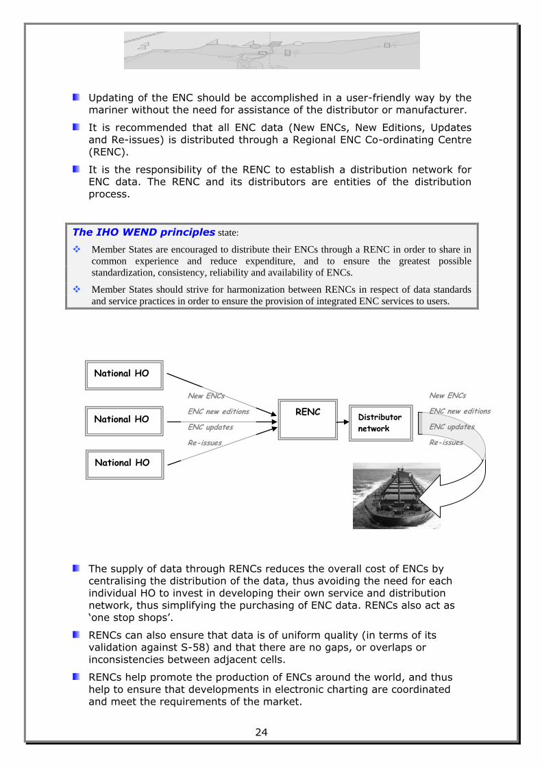
It is recommended that all ENC data (New ENCs, New Editions, Updates
and Re-issues) is distributed through a Regional ENC Co-ordinating Centre
(RENC).
It is the responsibility of the RENC to establish a distribution network for ENC data. The RENC and its distributors are entities of the distribution
process.
The IHO WEND principles state:
Member States are encouraged to distribute their ENCs through a RENC in order to share in
common experience and reduce expenditure, and to ensure the greatest possible
standardization, consistency, reliability and availability of ENCs.
Member States should strive for harmonization between RENCs in respect of data standards
and service practices in order to ensure the provision of integrated ENC services to users.
The supply of data through RENCs reduces the overall cost of ENCs by centralising the distribution of the data, thus avoiding the need for each
individual HO to invest in developing their own service and distribution
network, thus simplifying the purchasing of ENC data. RENCs also act as
„one stop shops‟.
RENCs can also ensure that data is of uniform quality (in terms of its validation against S-58) and that there are no gaps, or overlaps or
inconsistencies between adjacent cells.
RENCs help promote the production of ENCs around the world, and thus
help to ensure that developments in electronic charting are coordinated
and meet the requirements of the market.
National HO
National HO
National HO
RENC Distributor
network
New ENCs
ENC new editions
ENC updates
Re-issues
New ENCs
ENC new editions
ENC updates
Re-issues
25
SSTTEEPP 22 –– SSiiggnn AAggrreeeemmeenntt
Whatever distribution mechanism is adopted, where an outside organisation such as a RENC is involved, the rights and responsibilities of
each partner should be detailed in a signed agreement.
SSTTEEPP 33 –– DDiissttrriibbuuttiioonn FFoorrmmaatt
Distribution through a RENC is not mandatory. If data is not distributed
through a RENC, a security system should be applied to protect the
integrity of the data, prove authenticity, and prevent unauthorised copying. Reference should be made to S-63 (IHO Data Protection Scheme).
In addition to standard S-57 (either S-63 encrypted or unencrypted) ENCs
can also be distributed directly in the SENC format proprietary to an ECDIS
manufacturer. The SENC update mechanism should not be inferior to the
ENC - ECDIS update mechanism.
The IHO WEND principles also state that:
Member States will strive to ensure that, mariners, anywhere in the world, can obtain fully
updated ENCs for all shipping routes and ports across the world.
Member States will strive to ensure that their ENC data are available to users through
integrated services, each accessible to any ECDIS user (i.e., providing data in S-57 form), in
addition to any national distribution or system-specific SENC delivery.
A Member State responsible for any subsequent integration of a country’s data into a wider
service is responsible for validating the results of that integration.
Methods to be adopted should ensure that data bear a stamp or seal of approval of the issuing
HO.
Member States should work together so that the IHO Data Protection Scheme (S-63) is used
for ENC distribution to end users, to ensure data integrity, to safeguard national copyright in
ENC data, to protect the mariner from falsified products, and to ensure traceability.
When an encryption mechanism is employed to protect data, a failure of contractual
obligations by the user should not result in a complete termination of the service. This is to
assure that the safety of the vessel is not compromised.
In order to promote the use of ENCs in ECDIS, Member States are to strive for the greatest
possible user-friendliness of their services, and facilitate integrated services to the mariner.
In addition, the WEND Committee endorsed the following definition of integrated services:
“A variety of end-user services where each service is selling all its ENC data, regardless of
source, to the end user within a single service proposition embracing format, data protection
scheme and updating mechanism, packaged in a single exchange set.”
Useful Reference: Guidelines for the Implementation of the WEND
Principles
26
Page intentionally left blank
27
Glossary of Terms
Terms and Abbreviations relating to ENC/ECDIS
The following definitions have been principally taken from the Glossary of ECDIS
related terms (IHO S-32, Appendix 1, 2007). Reference has also been made to „The Electronic Chart‟, Chapter 16, Glossary (Hecht, Berking, Büttgenbach, Jonas,
Alexander).
AIS
An automatic communication and identification system intended to improve the
safety of navigation by assisting in the efficient operation of vessel traffic services (VTS), ship reporting, ship-to-ship and ship-to-shore operations.
A transponder is an example of an AIS. AIS information may be displayed on an ECDIS.
area
The 2-dimensional geometric primitive of an object that specifies location.
ARPA (Automatic Radar Plotting Aid)
A system wherein radar targets are automatically acquired and tracked and collision situations computer assessed and warnings given.
attribute
A characteristic of an object. Attributes are either qualitative or quantitative.
Attributes required for ECDIS are defined in Appendix A of S-57, IHO Object Catalogue.
C-47
IHO Capacity Building Publication 47, titled “Training Courses in Hydrography
and Nautical Cartography”
cartographic object
Feature object which contains information about the cartographic
representation (including text of real world entities).
The ENC Product Specification prohibits the use of cartographic objects in
ENCs.
cell
The basic unit for the distribution of ENC data covering a defined geographical area bounded by two meridians and two parallels, the content of which must
not exceed 5 Mbytes, and which is intended for a particular navigational
purpose.
chain
A sequence of one or more edges.
28
chain node
Data structure in which the geometry is described in terms of edges, isolated
nodes and connected nodes. Edges and connected nodes are topologically linked. Nodes are explicitly coded in the data structure. Areas are defined by
the sequence of edges that comprise their boundaries. Lines are comprised of edges. Point feature objects may only be referred to as isolated nodes.
CHRIS (Committee on Hydrographic Requirements for Information Systems)
A Committee of the IHO tasked with promoting and coordinating the
development of official digital products and services. CHRIS has now been superseded by the Hydrographic Services and Standards Committee (HSSC).
collection object
A feature object which describes the relationship between other objects. An example of a collection object in S-57 is "aggregation" which is used, for
example, to group together the different objects which together constitute a Traffic Separation Scheme.
compilation
In cartography, the selection, assembly, and graphic presentation of all
relevant information required for the preparation of a new map/chart or a new edition thereof. Such information may be derived from other maps/charts,
aerial photographs, surveys, new data, and other sources.
compilation scale
The scale at which the ENC data was compiled.
Note that the consistency recommendations (Ref I) indicate that compilation scale should be considered as the optimal scale for display for that ENC.
connected node
A node referred to as a beginning and/or end node by one or more edge.
Connected nodes are defined only in the chain-node, planar graph and full topology data structures.
data model
A conceptual specification of the sets of components and the relationships among the components pertaining to the specific phenomena defined by the
model reality. A data model is independent of specific systems or data structures. The S-57 data model defines real world entities as a combination of
descriptive and spatial characteristics. These characteristics are defined in terms of feature objects and spatial objects and the relationship between
them.
data set
A logical grouping of S-57 data to which the S-57 data set descriptive records
apply. The data set descriptive records contain meta data. The use of data set descriptive records is product specific and is, therefore, defined by a product
specification. If the data set descriptive records are repeated for each file in an exchange set, an instance of a file containing the data set descriptive records is
called a data set. If the data set descriptive records are encoded generally for the whole exchange set, the exchange set is referred to as a data set.
29
data structure
A computer interpretable format used for storing, accessing, transferring and
archiving data.
datum (vertical)
Any level surface (e.g. mean sea level) taken as a surface of reference from which to reckon elevations.
display category
The ECDIS Performance Standards establish three categories for SENC objects:
display base: The level of information which cannot be removed from the display. It consists of information that is
required at all times in all geographic areas and all
circumstances.
standard display: The level of SENC information that is shown when
a chart is first displayed on ECDIS. It is the recommended minimum level of display for safe
navigation.
all other information: displayed individually (by class) on demand.
edge
A one-dimensional spatial object, located by two or more coordinate pairs (or
two connected nodes). An edge must reference a connected node at both ends
and must not reference any other nodes.
electronic chart
Very broad term to describe the data, the software, and the electronic system, capable of displaying chart information. An electronic chart may or may not be
equivalent to the paper chart required by SOLAS.
Electronic Chart Display and Information System (ECDIS)
A navigation information system which with adequate back-up arrangements can be accepted as complying with the up-to-date chart required by regulation
V/20 of the 1974 SOLAS Convention, by displaying selected information from a
System Electronic Navigational Chart (SENC) with positional information from navigation sensors to assist the mariner in route planning and route
monitoring, and if required display additional navigation-related information.
Electronic Chart Systems (ECS)
Generic term for equipment which displays chart data but which is not intended to comply with the IMO Performance Standards for ECDIS, and is not intended
to satisfy the SOLAS Chapter V requirement to carry a navigational chart.
Electronic Navigational Chart (ENC)
The data base, standardized as to content, structure and format, issued for use
with ECDIS on the authority of government authorized hydrographic offices. The ENC contains all the chart information necessary for safe navigation and
may contain supplementary information in addition to that contained in the paper chart (eg sailing directions) which may be considered necessary for safe
navigation.
30
ENC Product Specification
Appendix B1 of S-57 which specifies the content, structure and other
mandatory aspects of an ENC.
exchange set
The set of files representing a complete, single purpose (i.e. product specific) data transfer. The ENC Product Specification defines an exchange set which
contains one Catalogue file and at least one data set file.
face
A two dimensional spatial object. A face is a continuous area defined by a loop of one or more edges which bound it. A face may contain interior holes,
defined by closing loops of edges. These interior boundaries must be within the
outer boundary. No boundary may cross itself or touch itself other than at the beginning/end node. None of the boundaries may touch or cross any other
boundary. Faces are defined only in the full topology data structure.
feature
Representation of a real world phenomenon. For example, a particular cardinal buoy represented through a symbol on a chart.
feature object
An object which contains the non-locational information about real world
entities. Feature objects are defined in Appendix A of S-57, IHO Object
Catalogue.
feature record
A feature record is the implemented term used in the S-57 data structure for a feature object (i.e. a feature object as defined in the data model is encoded as
a feature record in the data structure). There are four types of feature records: geo, meta, collection and cartographic.
geo object
A feature object which carries the descriptive characteristics of a real world
entity. The positional information is provided through the spatial object.
Geographic Information System (GIS)
A computer based system for handling and integrating data from a variety of
sources which is directly or indirectly spatially referenced to Earth.
geometric primitive
One of the three basic geometric units of representation: point, line and area.
Global Maritime Distress and Safety System (GMDSS)
A global communications service based upon automated systems, both satellite based and terrestrial, to provide distress alerting and promulgation of maritime
safety information to mariners. This system has been developed by IMO
through the SOLAS Convention.
Global Navigation Satellite System (GNSS)
A world-wide position, time and velocity radio determination system comprising space, ground and user segments of which GPS and GLONASS are
components.
31
GLONASS (Global Navigation Satellite System)
A space-based, radio-positioning, navigation and time-transfer system
operated by the Government of the Russian Federation. GLONASS to which differential corrections have been applied is known as Differential GLONASS
(DGLONASS).
GPS (Global Positioning System)
A space-based, radio-positioning, navigation and time-transfer system operated by the United States Government. GPS to which differential
corrections have been applied is known as Differential GPS (DGPS).
HSSC (Hydrographic Services and Standards Committee)
The technical steering committee of the IHO tasked, among other things, with
promoting and coordinating the development of official digital products and services.
International Electrotechnical Commission (IEC)
A worldwide non-governmental organization for standardization comprising all
national electrotechnical committees (IEC National Committees). The object of the IEC is to promote international cooperation on all questions concerning
standardization in the electrical and electronic fields. Committee 80, Working Group 7 of IEC is responsible for developing the Performance Requirements for
ECDIS to be published as document IEC 61174.
International Hydrographic Organization (IHO)
The IHO is an intergovernmental consultative and technical organization that
was established in 1921 to support the safety of navigation and the protection of the marine environment. The object of the organization is to bring about:
(a) The co-ordination of the activities of national hydrographic offices;
(b) The greatest possible uniformity in nautical charts and documents;
(c) The adoption of reliable and efficient methods of carrying out and exploiting hydrographic surveys;
(d) The development of the sciences in the field of hydrography and the
techniques employed in descriptive oceanography.
International Maritime Organization (IMO)
The specialized agency of the United Nations responsible for measures to improve the safety of international shipping and to prevent marine pollution
from ships.
isolated node
An isolated zero-dimensional spatial object that represents the geometric location of a point feature. An isolated node is never used as a beginning or
end node.
line
The one-dimensional geometric primitive of an object that specifies location.
meta object
A feature object which contains information about other objects. For example
compilation scale or vertical datum.
32
navigational purpose
The specific purpose for which a cell has been compiled. There are six such
purposes, namely berthing, harbour, approach, coastal, general and overview.
node
A zero-dimensional spatial object, located by a coordinate pair. A node is either isolated or connected.
Notice to Mariners (NtM)
A periodical notice issued by maritime administrations, or other competent
authorities, regarding changes in aids to navigation, dangers to navigation, important new soundings, and, in general, all such information as affects
nautical charts, sailing directions, light lists and other nautical publications.
object
An identifiable set of information. An object may have attributes and may be
related to other objects. Also see spatial object and feature object.
Object Catalogue
The Object Catalogue is the feature schema for S-57. Its primary function is to provide a description of real world entities. It contains a list of feature object
classes (each relating to a real world entity), attributes and allowable attribute values.
object class
A generic description of objects which have the same characteristics.
Examples of object classes in S-57 are "buoy, cardinal" and "caution area".
own ship's safety contour
The contour related to the own ship selected by the mariner from the contours
provided for in the SENC, to be used by ECDIS to distinguish on the display between the safe and the unsafe water, and for generating anti-grounding
alarms.
Performance Standards for ECDIS
Minimum performance requirements for ECDIS, adopted by IMO 5 December
2006 as MSC resolution and published as Annex to IMO Resolution MSC.232(82).
planar graph
A 2-dimensional data structure in which the geometry is described in terms of
nodes and edges which are topologically linked. A special case of a chain-node data structure in which edges must not cross. Connected nodes are formed at
all points where edges meet.
point
The 0-dimensional geometric primitive of an object that specifies location.
polygon
A non-self intersecting, closed chain defining the boundary of an area.
33
product specification
A defined subset of the entire specification combined with rules, tailored to the
intended usage of the transfer data. See ENC product specification.
Presentation Library
A set of mostly digital specifications, composed of symbol libraries, colour schemes, look-up tables and rules, linking every object class and attribute of
the SENC to the appropriate presentation of the ECDIS display. Published by IHO as Annex A to S-52.
raster
A regular array with information pertaining to each element (pixel) or group of
elements.
Regional ENC Coordinating Centre (RENC)
An organizational entity where IHO Member States have established
cooperation amongst each other to guarantee a world-wide consistent level of high quality data, and for bringing about coordinated services with official ENCs
and updates to them
Regional Hydrographic Commission (RHC)
A body created under IHO Resolution T 1.3 composed of representatives from member states‟ hydrographic services within a defined geographic area
(typically an INT charting area), meeting at regular intervals to discuss mutual
hydrographic and chart production issues.
Re-issue
A re-issue of an ENC includes all the updates applied to the ENC up to the date of the reissue. A re-issue does not contain any new information additional to
that previously issued by updates. The update sequence is not interrupted by a re-issue. After a re-issue, subsequent updates may be incorporated into the
SENC created from this reissue or to the SENC created from the original ENC and kept continuously updated.
S-4
IHO Publication S-4, titled ”Regulations of the IHO for International (INT) Charts and Chart Specifications of the IHO”.
S-8
IHO Publication S-8, titled ”FIG/IHO/ICA Standards of Competence for Nautical
Cartographers”.
S-52
IHO Publication S-52, titled "Specifications for chart content and display aspects of ECDIS".
S-57
IHO Publication S-57, titled “IHO Transfer Standard for Digital Hydrographic Data”. S-57 is The international transfer standard for digital hydrographic data.
The major components of S-57 Edition 3.1 are; Theoretical Data Model, Data
Structure, Object Catalogue, ENC Product Specification, Use of the Object Catalogue for ENC.
34
S-58
IHO Publication S-58, titled “IHO Recommended ENC Validation Checks”. S-58
specifies the checks that, as a minimum, producers of ENC validation tools should include in their validation software.
S-62
IHO Publication S-62, titled “ENC Producer Codes”. S-62 provides a list of
Agency Codes for all producers of ENCs, in particular Hydrographic Offices.
S-63
IHO Publication S-63, titled “IHO Data Protection Scheme”. S-63 describes the IHO ENC security scheme and provides test data. It is intended for use by all
those ECDIS manufacturers and data distributors participating in an ENC
service with data encrypted.
S-66
IHO Publication S-66, titled “Facts about electronic charts and carriage requirements”. S-66 provides a high level guide to the production,
maintenance and distribution of Electronic Navigational Charts (ENCs).
S-100
IHO Publication S-100, titled “IHO Universal Hydrographic Data Model”. S-100 is a new standard that will eventually supersede S-57. It complies with the ISO
19100 series of geographic standards and will support a greater variety of
hydrographic-related digital data sources, products, and customers than S-57.
safety depth
The depth defined by the mariner, e.g. the ship's draft plus underkeel clearance, to be used by the ECDIS to emphasize soundings on the display
equal to or less than this value.
SOLAS (Safety Of Life At Sea)
International Convention for the Safety of Life at Sea developed by IMO. The contracting governments undertake to promulgate all laws, decrees, orders
and regulations and to take all other steps which may be necessary to give the
present Convention full and complete effect, so as to ensure that, from the point of view of safety of life, a ship is fit for the service for which it is
intended.
spaghetti data
A data structure in which all lines and points are unrelated to each other (i.e. no topological relationships exist in the data structure). This data structure is
not permitted for ENC.
spatial object
An object which contains locational information about real world entities. For
example, in S-57 the location of a buoy or the boundary of a caution area.
System Electronic Navigational Chart (SENC)
A data base resulting from the transformation of the ENC by ECDIS for appropriate use, updates to the ENC by appropriate means and other data
added by the mariner. It is this data base that is actually accessed by ECDIS for the display generation and other navigational functions, and is equivalent to
an up-to-date paper chart. The SENC may also contain information from other sources.
35
topology
The set of properties of geometric forms (such as connectivity, neighbourhood)
which is defined with the data model remaining invariant when subject to a continuous transformation.
The level of topology chosen for the ENC allows for colour fill, activation of area warnings, e.g. depth area warnings, cautionary areas. The different levels of
topology are described in the S-57 Data Model.
Transfer Standard Maintenance and Applications Development Working
Group (TSMAD)
An HSSC working group that is responsible for the maintenance of digital data
standards including S-57 and S-100 to satisfy new hydrographic requirements.
update
Either short for update information or, as a verb, applying the update
mechanism. An ENC Update (official update) is a data set produced for changing an existing ENC in the ECDIS SENC (automatic updating). An ENC
Update must conform to the ER application profile of S-57.
Use of the Object Catalogue
Annex A of S-57 Appendix B.1 describing how to encode information relevant to a specific navigational purpose. Must be used in conjunction with the ENC
Product Specification.
Use of the Object Catalogue is maintained by means of new editions, published as required by the Transfer Standard Maintenance and Applications
Development Working Group. The contents of a new edition do not invalidate the contents of the previous edition.
vector
Direct connection between two points, either given as two sets of coordinates
(points), or by direction and distance from one given set of coordinates, or a point in a vector space defined by one set of coordinates relative to the origin
of a coordinate system.
WEND (World-wide Electronic Navigational chart Database)
A common, worldwide network of ENC datasets based on IHO standards
designed specifically to meet the needs of international maritime traffic using ECDIS which conform to the IHO Performance Standards for ECDIS.
World Geodetic System (WGS)
A global geodetic reference system developed by the USA for satellite position
fixing and recommended by IHO for hydrographic and cartographic use.
Published by the
International Hydrographic Bureau 4, Quai Antoine 1er
B.P 445 - MC 98011 MONACO Cedex Principauté de Monaco
Telefax: (+377) 93 10 81 40 E-mail: [email protected]
Web http://www.iho.int
World-Wide Navigational Warning System (WWNWS)
A service established for the purpose of coordinating the transmission of radio navigational warnings in geographical areas using coastal and satellite
communication services.
Recommended


![IHO S-100: The New IHO Hydrographic Geospatial … hydrographic review may 2009 →iho s-100) iho s-100 [] .Published in: International Hydrographic Review · 2009Authors: Robert Ward](https://img.pdfslide.us/doc/110x75/5ae4a48c7f8b9a495c8ed661/iho-s-100-the-new-iho-hydrographic-geospatial-hydrographic-review-may-2009.jpg)