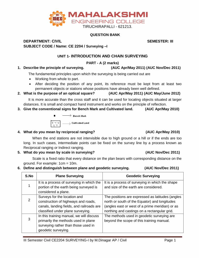
III Semester Civil CE2204 SURVEYING-I by M.Dinagar AP / Civil Page 1
MAHALAKSHMI ENGINEERING COLLEGE
TIRUCHIRAPALLI - 621213.
QUESTION BANK
DEPARTMENT: CIVIL SEMESTER: III
SUBJECT CODE / Name: CE 2204 / Surveying –I
UNIT 1- INTRODUCTION AND CHAIN SURVEYING
PART - A (2 marks)
1. Describe the principle of surveying. (AUC Apr/May 2011) (AUC Nov/Dec 2011)
The fundamental principles upon which the surveying is being carried out are
Working from whole to part.
After deciding the position of any point, its reference must be kept from at least two
permanent objects or stations whose positions have already been well defined.
2. What is the purpose of an optical square? (AUC Apr/May 2011) (AUC May/June 2012)
It is more accurate than the cross staff and it can be used for locating objects situated at larger
distances. It is small and compact hand instrument and works on the principle of reflection.
3. Give the conventional signs for Bench Mark and Cultivated land. (AUC Apr/May 2010)
4. What do you mean by reciprocal ranging? (AUC Apr/May 2010)
When the end stations are not intervisible due to high ground or a hill or if the ends are too
long. In such cases, intermediate points can be fixed on the survey line by a process known as
Reciprocal ranging or Indirect ranging.
5. What do you mean by scale in surveying? (AUC Nov/Dec 2011)
Scale is a fixed ratio that every distance on the plan bears with corresponding distance on the
ground. For example: 1cm = 10m.
6. Define and distinguish between plane and geodetic surveying. (AUC Nov/Dec 2011)
S.No Plane Surveying Geodetic Surveying
1 It is a process of surveying in which the
portion of the earth being surveyed is
considered a plane.
It is a process of surveying in which the shape
and size of the earth are considered.
2 Surveys for the location and
construction of highways and roads,
canals, landing fields, and railroads are
classified under plane surveying.
The positions are expressed as latitudes (angles
north or south of the Equator) and longitudes
(angles east or west of a prime meridian) or as
northing and castings on a rectangular grid.
3 In this training manual, we will discuss
primarily the methods used in plane
surveying rather than those used in
geodetic surveying.
The methods used in geodetic surveying are
beyond the scope of this training manual.
III Semester Civil CE2204 SURVEYING-I by M.Dinagar AP / Civil Page 2
7. Define conditioned triangles. (AUC Nov/Dec 2010)
The accuracy of a triangulation system, in which any error in angular measurement has a
minimum effect upon the computed lengths, is known as well-conditioned triangle.
8. Explain the range of reciprocal ranging. (AUC May/June 2013)
The vision ranging and line ranger can be adopted only when the end stations are inter-
visible. The line of sight between two stations is obstructed by natural or man-made objects or not
clearly visible. Under such conditions, indirect or reciprocal ranging is applicable.
9. What do you mean by plane surveying? (AUC May/June 2013)
Plane surveying is a process of surveying in which the portion of the earth being surveyed is
considered a plane. In this training manual, we used in plane surveying rather than those used in
geodetic surveying.
10. What is meant by geodetic surveying? (AUC Nov/Dec 2012)
Geodetic surveying is a process of surveying in which the shape and size of the earth are
considered. The methods used in geodetic surveying are beyond the scope of this training manual.
11. What do you require indirect ranging? (AUC Nov/Dec 2012)
Two intermediate points C1 and D1 are selected which are not along the line of sight AB
(survey line). Stations C1 and D1 are approximately in line such that line C1 D1 is approximately
paralleled to AB. C1 is so situated that both D1 and B are visible from it, while from D1 both A and C1
can be sighted.
12. Name the different methods adopted in scale of a plan/map. (AUC May/June 2012)
Plain Scale
Diagonal Scale
Vernier Scale
Scale of chords
13. What are arrows? (AUC Nov/Dec 2009)
Arrows are also called marking or chaining pins, and are used to mark the end of each chain
during the process of chaining.
14. What is plumb Bob? (AUC Nov/Dec 2009)
Plumb Bob is used to locate points directly below or above another point. It is also used for
accurately centering of compass or level or theodolite over a station mark, and for testing the
verticality of ranging poles.
15. Define surveying.
Surveying is defined as the science of making measurements of the earth specifically the
surface of the earth.
16. What are the works of a surveyor in office?
In office work, converting field measurements (also called reducing) involves the process of
computing, adjusting, and applying a standard rule to numerical values.
17. What are the types of corrections to be applied?
Correction for Length.
Correction for Temperature.
Correction for Pull.
Correction for Sag.
Correction for Slope.
III Semester Civil CE2204 SURVEYING-I by M.Dinagar AP / Civil Page 3
18. What are the instruments used in chain surveying?
a) Instruments used for measuring distances
Chain
Tape
b) Instruments used for marking survey stations
Ranging rod
Offset rod
Laths and whites
Pegs
c) Instruments used for setting right angles
Cross staff
Optical square
d) Other instruments:
Arrow
Plumb bob
19. What are the different types of errors in linear measurement?
a) Instrumental errors
b) Observational errors
Gross Errors
Systematic Errors
Accidental or random errors
20. What is meant by direct ranging?
When intermediate ranging rods are fixed on a straight line by direct observation from end
stations, the process is known as Direct ranging.
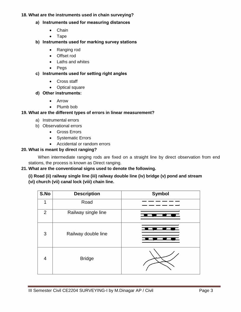
21. What are the conventional signs used to denote the following.
(i) Road (ii) railway single line (iii) railway double line (iv) bridge (v) pond and stream
(vi) church (vii) canal lock (viii) chain line.
S.No Description Symbol
1 Road
2 Railway single line
3
Railway double line
4
Bridge
III Semester Civil CE2204 SURVEYING-I by M.Dinagar AP / Civil Page 4
5
Pond and stream
6
Church
7
Canal lock
8 Chain line
PART - B (16 marks)
1. Write short notes on
a) An Engineers chain.
b) Cross staff. (AUC Apr/May 2011)
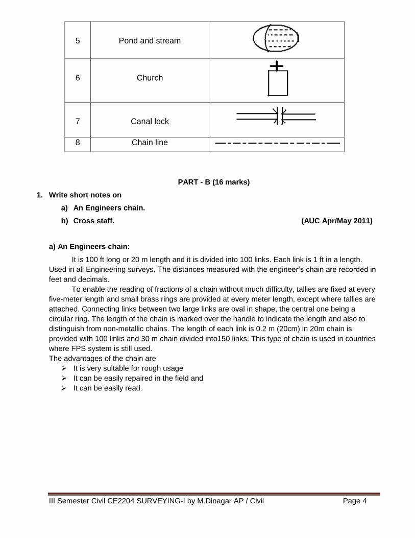
a) An Engineers chain:
It is 100 ft long or 20 m length and it is divided into 100 links. Each link is 1 ft in a length.
Used in all Engineering surveys. The distances measured with the engineer’s chain are recorded in
feet and decimals.
To enable the reading of fractions of a chain without much difficulty, tallies are fixed at every
five-meter length and small brass rings are provided at every meter length, except where tallies are
attached. Connecting links between two large links are oval in shape, the central one being a
circular ring. The length of the chain is marked over the handle to indicate the length and also to
distinguish from non-metallic chains. The length of each link is 0.2 m (20cm) in 20m chain is
provided with 100 links and 30 m chain divided into150 links. This type of chain is used in countries
where FPS system is still used.
The advantages of the chain are
It is very suitable for rough usage
It can be easily repaired in the field and
It can be easily read.
III Semester Civil CE2204 SURVEYING-I by M.Dinagar AP / Civil Page 5
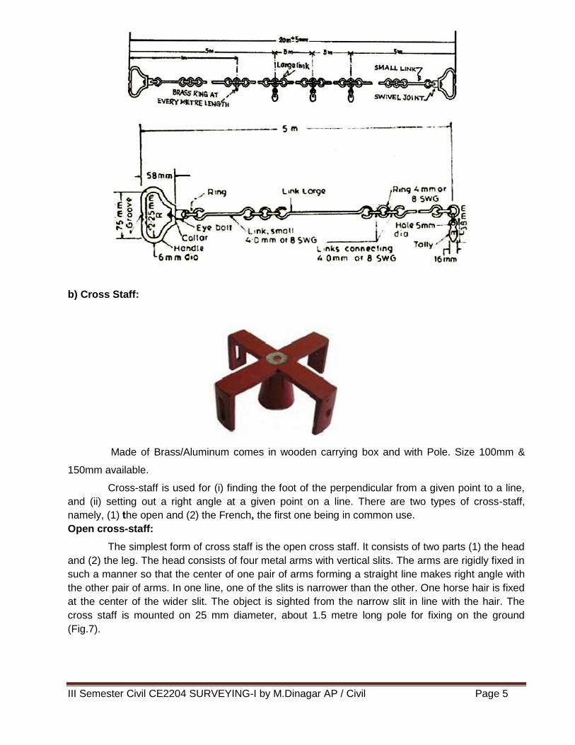
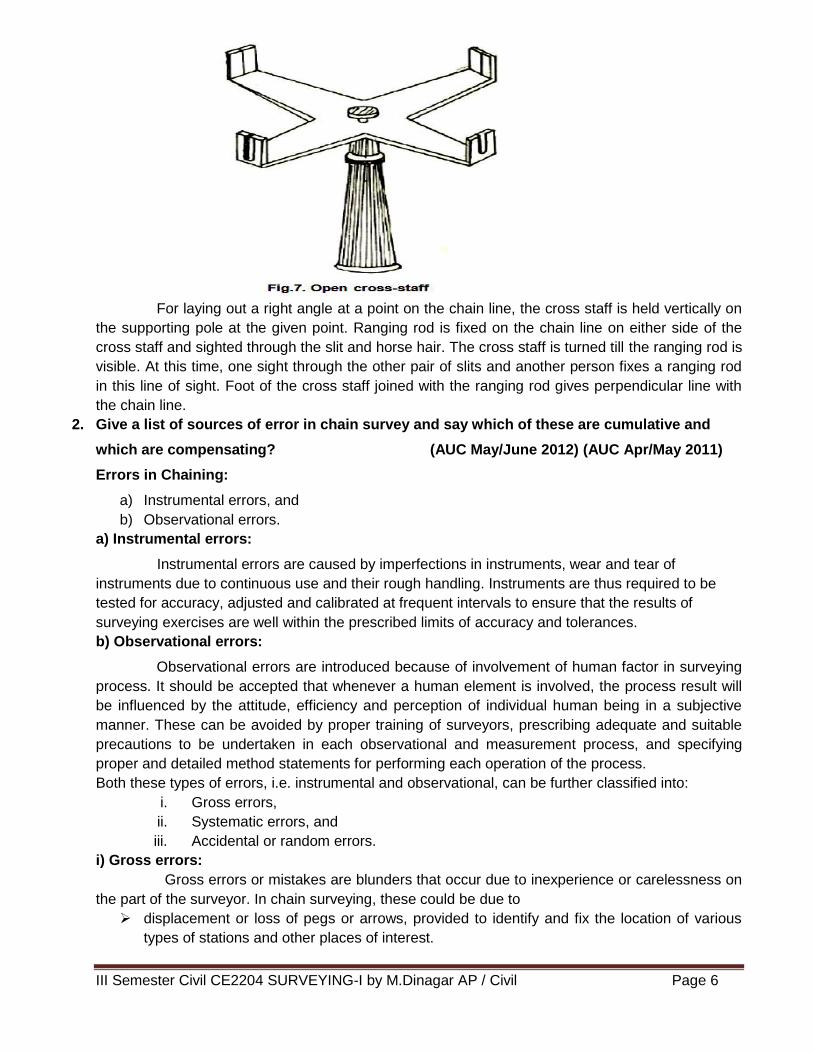
b) Cross Staff:
Made of Brass/Aluminum comes in wooden carrying box and with Pole. Size 100mm &
150mm available.
Cross-staff is used for (i) finding the foot of the perpendicular from a given point to a line,
and (ii) setting out a right angle at a given point on a line. There are two types of cross-staff,
namely, (1) the open and (2) the French, the first one being in common use.
Open cross-staff:
The simplest form of cross staff is the open cross staff. It consists of two parts (1) the head
and (2) the leg. The head consists of four metal arms with vertical slits. The arms are rigidly fixed in
such a manner so that the center of one pair of arms forming a straight line makes right angle with
the other pair of arms. In one line, one of the slits is narrower than the other. One horse hair is fixed
at the center of the wider slit. The object is sighted from the narrow slit in line with the hair. The
cross staff is mounted on 25 mm diameter, about 1.5 metre long pole for fixing on the ground
(Fig.7).
III Semester Civil CE2204 SURVEYING-I by M.Dinagar AP / Civil Page 6
For laying out a right angle at a point on the chain line, the cross staff is held vertically on
the supporting pole at the given point. Ranging rod is fixed on the chain line on either side of the
cross staff and sighted through the slit and horse hair. The cross staff is turned till the ranging rod is
visible. At this time, one sight through the other pair of slits and another person fixes a ranging rod
in this line of sight. Foot of the cross staff joined with the ranging rod gives perpendicular line with
the chain line.
2. Give a list of sources of error in chain survey and say which of these are cumulative and
which are compensating? (AUC May/June 2012) (AUC Apr/May 2011)
Errors in Chaining:
a) Instrumental errors, and
b) Observational errors.
a) Instrumental errors:
Instrumental errors are caused by imperfections in instruments, wear and tear of
instruments due to continuous use and their rough handling. Instruments are thus required to be
tested for accuracy, adjusted and calibrated at frequent intervals to ensure that the results of
surveying exercises are well within the prescribed limits of accuracy and tolerances.
b) Observational errors:
Observational errors are introduced because of involvement of human factor in surveying
process. It should be accepted that whenever a human element is involved, the process result will
be influenced by the attitude, efficiency and perception of individual human being in a subjective
manner. These can be avoided by proper training of surveyors, prescribing adequate and suitable
precautions to be undertaken in each observational and measurement process, and specifying
proper and detailed method statements for performing each operation of the process.
Both these types of errors, i.e. instrumental and observational, can be further classified into:
i. Gross errors,
ii. Systematic errors, and
iii. Accidental or random errors.
i) Gross errors:
Gross errors or mistakes are blunders that occur due to inexperience or carelessness on
the part of the surveyor. In chain surveying, these could be due to
displacement or loss of pegs or arrows, provided to identify and fix the location of various
types of stations and other places of interest.
III Semester Civil CE2204 SURVEYING-I by M.Dinagar AP / Civil Page 7
reading the chain or tape in a wrong manner or using an instrument in an incorrect way, and
Wrong recoding of measurements in the record book, e.g. field book.
There is no room for gross errors or blunders in the surveying processes. If gross errors are
detected, the entire surveying process and measurements are required to be repeated afresh,
resulting in substantial loss of time and resources. Such errors can be avoided by proper training
and testing of surveyors, adopting standard procedures, even to the minute details and carrying out
the survey work with utmost care.
ii) Systematic errors:
Systematic errors follow some specific pattern according to some mathematical or physical
law. The error could be cumulative, i.e. occurring in the same direction and tends to accumulate
affecting the accuracy of measurements to a great extent. In the context of chain surveying, these
could be due to:
Erroneous length of chain or tape (+ve or –ve),
Erroneous ranging,
Links in chain not straight (local bends) due to rough handling or twisting of metallic tapes,
Non-horizontally of chain/tape over rough ground terrain,
Sag in chain or tape, when it is stretched across a depression in ground,
Variation in temperature and/or dampness, and
Variation in pull applied during measurement.
These errors could be identified and adjusted and can be modeled. Suitable corrections can
be applied to the measurements for obtaining greater accuracy. Following are some of the
important corrections applied to measurements using chain or tape:
Correction for Erroneous Length of Chain/Tape:
The chain surveying depends only on linear measurement of distances. For traversing only
the errors in distance measurements are of importance and significance. Measuring devise either
chain or tape can either be longer or shorter than the designated length. The measured distance
will be smaller than the actual if the length of chain is longer than the designated length. It will be
larger than the actual if the chain is shorter than the designated length. The actual measured
distance can be corrected by the following formula:
True or Correct Distance =
L
L' X measured distance
where, L′ = Actual incorrect length of chain, and
L = Designated length of chain.
Correction for Temperature:
Correction for temperature is applied if the temperature in the field is more than the
temperature at which the tape/chain was standardized. This correction (Ct) is given by the following
formula:
Ct α (Tm To) L
Where, α = Coefficient of thermal expansion,
Tm = Mean temperature in the field during measurement,
To = Standard temperature for the tape, and
L = Measured distance.
III Semester Civil CE2204 SURVEYING-I by M.Dinagar AP / Civil Page 8
Correction for Pull:
CP =
AE
PoPL
Where, P = Pull applied during measurements (kg or N),
Po = Standard pull,
L = Measured length,
A = Cross-sectional area of the tape (cm2 or mm2), and
E = Young’s modulus of elasticity (kg/cm2 or N/mm2).
Correction for Sag:
Correction for sag is applied when the tape is stretched on supports between two points, it
takes the form of a horizontal catenary. The horizontal distance will be less than the distance along
the curve. The difference between horizontal distance and the measured length along catenary is
called sag correction and it is always negative.
CS =
2
2 224
L wL
n P
When unit weight is given,
CS =
2
2 224
L W
n P
Where, L = the length of the tape (in m) suspended between the supports,
P = Pull applied in kg or N, and
w = Weight of the tape in kg or N per m run.
W = Total weight of tape in kg
n = Number of spans
iii) Random or Accidental Errors:
Random or Accidental errors can occur due to lack of perfection of human eye and or
human behavior. Even the best and efficient surveyor can have fatigue effect after working for long
duration in strenuous environment causing observational errors. The random errors cannot be
eliminated entirely, whatever precautions are undertaken. These may, however, occur in either
direction and hence, tend to compensate and, thus, are not serious in nature. These normally follow
the law of chance and, thus, can be analysed with the help of probability theory. Using suitable
probability distribution functions, these errors can then be adjusted, distributed among various
measurements and accounted for. Each surveying method or process can be assigned a reliability
factor (or risk factor) for accuracy depending on the analysis of probability behavior.
III Semester Civil CE2204 SURVEYING-I by M.Dinagar AP / Civil Page 9
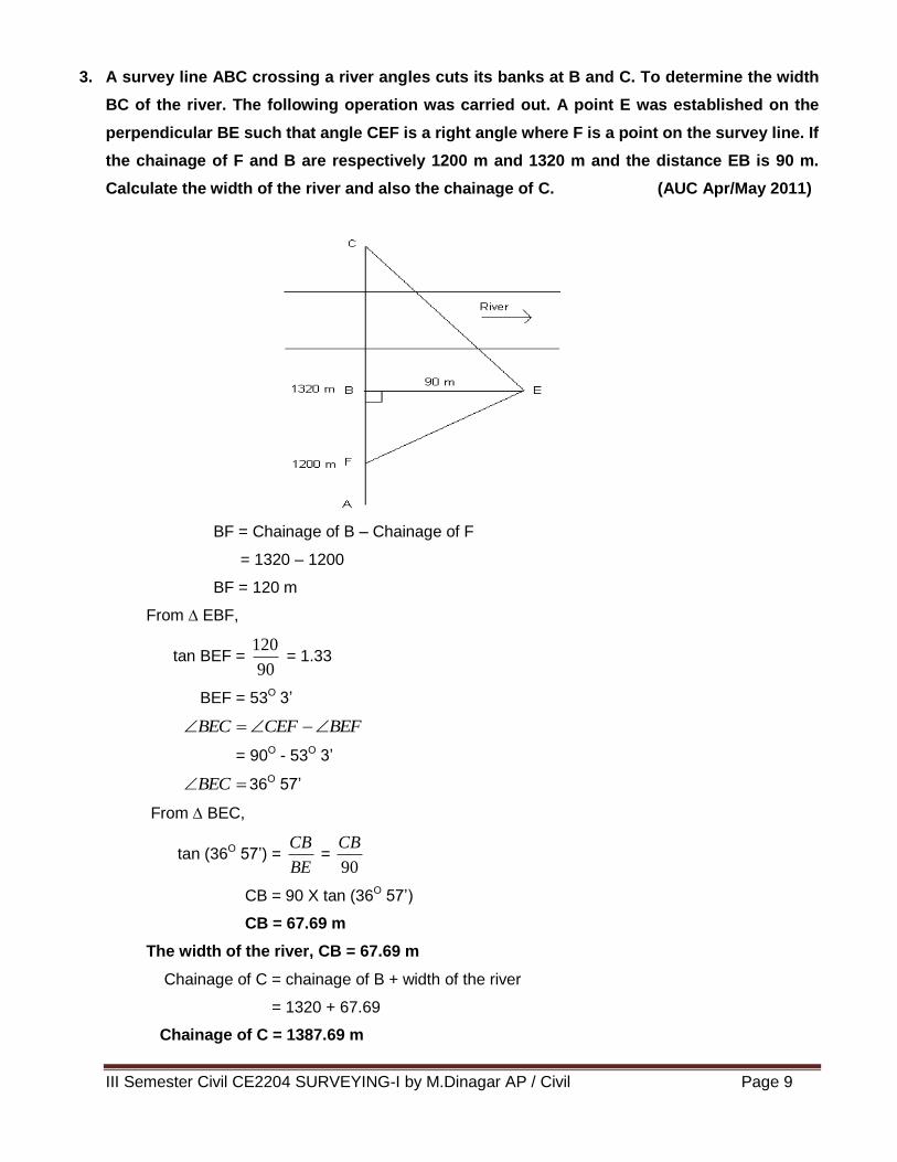
3. A survey line ABC crossing a river angles cuts its banks at B and C. To determine the width
BC of the river. The following operation was carried out. A point E was established on the
perpendicular BE such that angle CEF is a right angle where F is a point on the survey line. If
the chainage of F and B are respectively 1200 m and 1320 m and the distance EB is 90 m.
Calculate the width of the river and also the chainage of C. (AUC Apr/May 2011)
BF = Chainage of B – Chainage of F
= 1320 – 1200
BF = 120 m
From ∆ EBF,
tan BEF = 90
120 = 1.33
BEF = 53O 3’
BEFCEFBEC
= 90O - 53O 3’
BEC 36O 57’
From ∆ BEC,
tan (36O 57’) = BE
CB =
90
CB
CB = 90 X tan (36O 57’)
CB = 67.69 m
The width of the river, CB = 67.69 m
Chainage of C = chainage of B + width of the river
= 1320 + 67.69
Chainage of C = 1387.69 m
III Semester Civil CE2204 SURVEYING-I by M.Dinagar AP / Civil Page 10
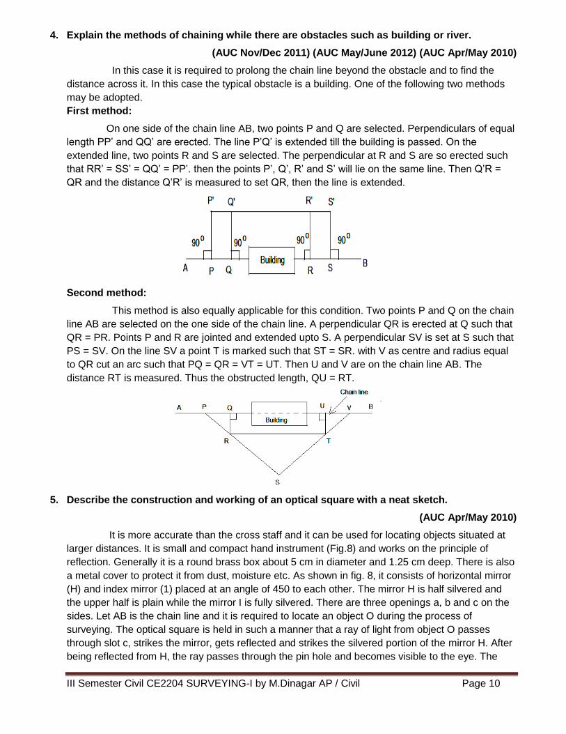
4. Explain the methods of chaining while there are obstacles such as building or river.
(AUC Nov/Dec 2011) (AUC May/June 2012) (AUC Apr/May 2010)
In this case it is required to prolong the chain line beyond the obstacle and to find the
distance across it. In this case the typical obstacle is a building. One of the following two methods
may be adopted.
First method:
On one side of the chain line AB, two points P and Q are selected. Perpendiculars of equal
length PP’ and QQ’ are erected. The line P’Q’ is extended till the building is passed. On the
extended line, two points R and S are selected. The perpendicular at R and S are so erected such
that RR’ = SS’ = QQ’ = PP’. then the points P’, Q’, R’ and S’ will lie on the same line. Then Q’R =
QR and the distance Q’R’ is measured to set QR, then the line is extended.
Second method:
This method is also equally applicable for this condition. Two points P and Q on the chain
line AB are selected on the one side of the chain line. A perpendicular QR is erected at Q such that
QR = PR. Points P and R are jointed and extended upto S. A perpendicular SV is set at S such that
PS = SV. On the line SV a point T is marked such that ST = SR. with V as centre and radius equal
to QR cut an arc such that PQ = QR = VT = UT. Then U and V are on the chain line AB. The
distance RT is measured. Thus the obstructed length, QU = RT.
5. Describe the construction and working of an optical square with a neat sketch.
(AUC Apr/May 2010)
It is more accurate than the cross staff and it can be used for locating objects situated at
larger distances. It is small and compact hand instrument (Fig.8) and works on the principle of
reflection. Generally it is a round brass box about 5 cm in diameter and 1.25 cm deep. There is also
a metal cover to protect it from dust, moisture etc. As shown in fig. 8, it consists of horizontal mirror
(H) and index mirror (1) placed at an angle of 450 to each other. The mirror H is half silvered and
the upper half is plain while the mirror I is fully silvered. There are three openings a, b and c on the
sides. Let AB is the chain line and it is required to locate an object O during the process of
surveying. The optical square is held in such a manner that a ray of light from object O passes
through slot c, strikes the mirror, gets reflected and strikes the silvered portion of the mirror H. After
being reflected from H, the ray passes through the pin hole and becomes visible to the eye. The
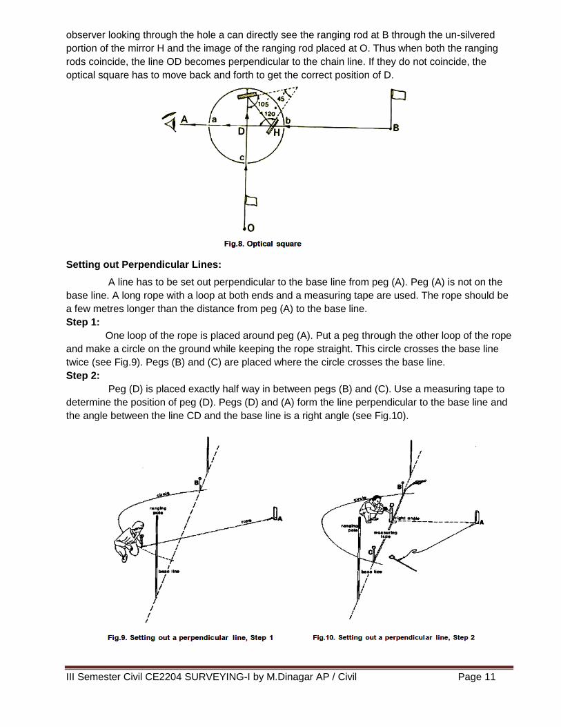
III Semester Civil CE2204 SURVEYING-I by M.Dinagar AP / Civil Page 11
observer looking through the hole a can directly see the ranging rod at B through the un-silvered
portion of the mirror H and the image of the ranging rod placed at O. Thus when both the ranging
rods coincide, the line OD becomes perpendicular to the chain line. If they do not coincide, the
optical square has to move back and forth to get the correct position of D.
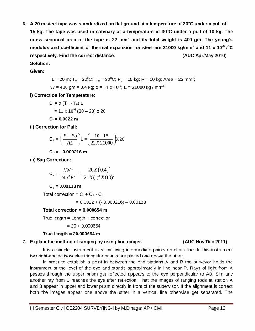
Setting out Perpendicular Lines:
A line has to be set out perpendicular to the base line from peg (A). Peg (A) is not on the
base line. A long rope with a loop at both ends and a measuring tape are used. The rope should be
a few metres longer than the distance from peg (A) to the base line.
Step 1:
One loop of the rope is placed around peg (A). Put a peg through the other loop of the rope
and make a circle on the ground while keeping the rope straight. This circle crosses the base line
twice (see Fig.9). Pegs (B) and (C) are placed where the circle crosses the base line.
Step 2:
Peg (D) is placed exactly half way in between pegs (B) and (C). Use a measuring tape to
determine the position of peg (D). Pegs (D) and (A) form the line perpendicular to the base line and
the angle between the line CD and the base line is a right angle (see Fig.10).
III Semester Civil CE2204 SURVEYING-I by M.Dinagar AP / Civil Page 12
6. A 20 m steel tape was standardized on flat ground at a temperature of 20oC under a pull of
15 kg. The tape was used in catenary at a temperature of 30oC under a pull of 10 kg. The
cross sectional area of the tape is 22 mm2 and its total weight is 400 gm. The young’s
modulus and coefficient of thermal expansion for steel are 21000 kg/mm2 and 11 x 10-6 /oC
respectively. Find the correct distance. (AUC Apr/May 2010)
Solution:
Given:
L = 20 m; T0 = 20oC; Tm = 30oC; Po = 15 kg; P = 10 kg; Area = 22 mm2;
W = 400 gm = 0.4 kg; α = 11 x 10-6; E = 21000 kg / mm2
i) Correction for Temperature:
Ct = α (Tm - T0) L
= 11 x 10-6 (30 – 20) x 20
Ct = 0.0022 m
ii) Correction for Pull:
CP =
AE
PoPL =
10 15
22 21000X
X 20
CP = - 0.000216 m
iii) Sag Correction:
Cs = 22
2
24 Pn
LW =
2
2 2
20 0.4
24 (1) (10)
X
X X
Cs = 0.00133 m
Total correction = Ct + CP - Cs
= 0.0022 + (- 0.000216) – 0.00133
Total correction = 0.000654 m
True length = Length + correction
= 20 + 0.000654
True length = 20.000654 m
7. Explain the method of ranging by using line ranger. (AUC Nov/Dec 2011)
It is a simple instrument used for fixing intermediate points on chain line. In this instrument
two right-angled isosceles triangular prisms are placed one above the other.
In order to establish a point in between the end stations A and B the surveyor holds the
instrument at the level of the eye and stands approximately in line near P. Rays of light from A
passes through the upper prism get reflected appears to the eye perpendicular to AB. Similarly
another ray from B reaches the eye after reflection. That the images of ranging rods at station A
and B appear in upper and lower prism directly in front of the supervisor. If the alignment is correct
both the images appear one above the other in a vertical line otherwise get separated. The
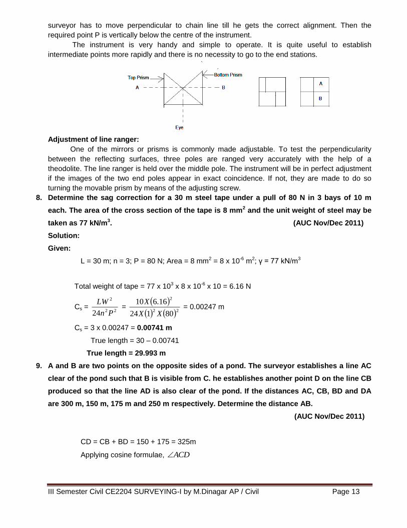
III Semester Civil CE2204 SURVEYING-I by M.Dinagar AP / Civil Page 13
surveyor has to move perpendicular to chain line till he gets the correct alignment. Then the
required point P is vertically below the centre of the instrument.
The instrument is very handy and simple to operate. It is quite useful to establish
intermediate points more rapidly and there is no necessity to go to the end stations.
Adjustment of line ranger:
One of the mirrors or prisms is commonly made adjustable. To test the perpendicularity
between the reflecting surfaces, three poles are ranged very accurately with the help of a
theodolite. The line ranger is held over the middle pole. The instrument will be in perfect adjustment
if the images of the two end poles appear in exact coincidence. If not, they are made to do so
turning the movable prism by means of the adjusting screw.
8. Determine the sag correction for a 30 m steel tape under a pull of 80 N in 3 bays of 10 m
each. The area of the cross section of the tape is 8 mm2 and the unit weight of steel may be
taken as 77 kN/m3. (AUC Nov/Dec 2011)
Solution:
Given:
L = 30 m; n = 3; P = 80 N; Area = 8 mm2 = 8 x 10⁻⁶ m2; γ = 77 kN/m3
Total weight of tape = 77 x 103 x 8 x 10-6 x 10 = 6.16 N
Cs = 22
2
24 Pn
LW =
22
2
80124
16.610
XX
X = 0.00247 m
Cs = 3 x 0.00247 = 0.00741 m
True length = 30 – 0.00741
True length = 29.993 m
9. A and B are two points on the opposite sides of a pond. The surveyor establishes a line AC
clear of the pond such that B is visible from C. he establishes another point D on the line CB
produced so that the line AD is also clear of the pond. If the distances AC, CB, BD and DA
are 300 m, 150 m, 175 m and 250 m respectively. Determine the distance AB.
(AUC Nov/Dec 2011)
CD = CB + BD = 150 + 175 = 325m
Applying cosine formulae, ACD
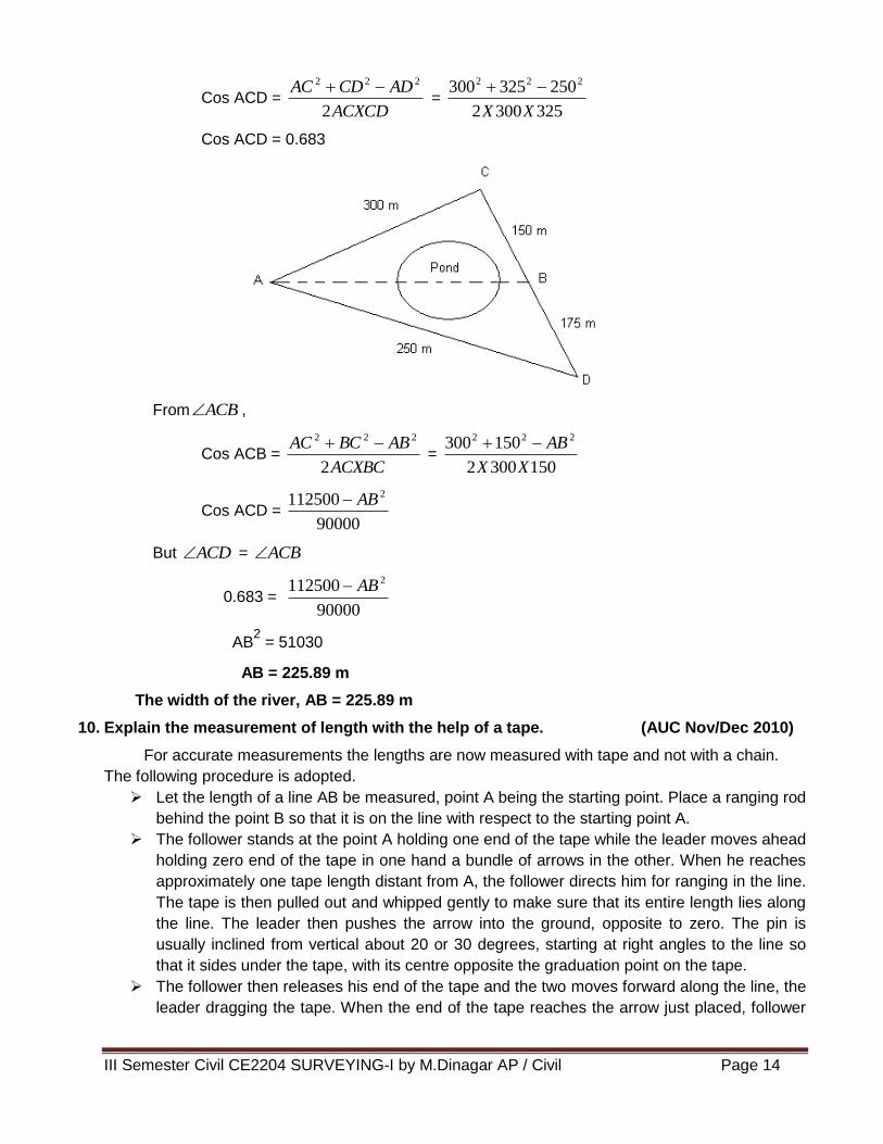
III Semester Civil CE2204 SURVEYING-I by M.Dinagar AP / Civil Page 14
Cos ACD = ACXCD
ADCDAC
2
222 =
3253002
250325300 222
XX
Cos ACD = 0.683
From ACB ,
Cos ACB = ACXBC
ABBCAC
2
222 =
1503002
150300 222
XX
AB
Cos ACD = 90000
112500 2AB
But ACD = ACB
0.683 = 90000
112500 2AB
AB2 = 51030
AB = 225.89 m
The width of the river, AB = 225.89 m
10. Explain the measurement of length with the help of a tape. (AUC Nov/Dec 2010)
For accurate measurements the lengths are now measured with tape and not with a chain.
The following procedure is adopted.
Let the length of a line AB be measured, point A being the starting point. Place a ranging rod
behind the point B so that it is on the line with respect to the starting point A.
The follower stands at the point A holding one end of the tape while the leader moves ahead
holding zero end of the tape in one hand a bundle of arrows in the other. When he reaches
approximately one tape length distant from A, the follower directs him for ranging in the line.
The tape is then pulled out and whipped gently to make sure that its entire length lies along
the line. The leader then pushes the arrow into the ground, opposite to zero. The pin is
usually inclined from vertical about 20 or 30 degrees, starting at right angles to the line so
that it sides under the tape, with its centre opposite the graduation point on the tape.
The follower then releases his end of the tape and the two moves forward along the line, the
leader dragging the tape. When the end of the tape reaches the arrow just placed, follower
III Semester Civil CE2204 SURVEYING-I by M.Dinagar AP / Civil Page 15
calls out “tape”. He then picks up the end of the tape and lines the leader in and the
procedure is repeated as in step 2.
When the second arrow has been established by the leader, the follower picks up the first
arrow and both the persons move ahead as described in step 3. The procedure is repeated
until ten tape lengths have been measured. the surveyor records the transfer of arrows in
the field book.
At the end of the line, at B, the last measurement will generally be a partial tape length from
the last arrow set to the end point of the line. The leader holds the end of the tape at B while
the follower pulls the tape back till it becomes taut and then reads against the arrow.
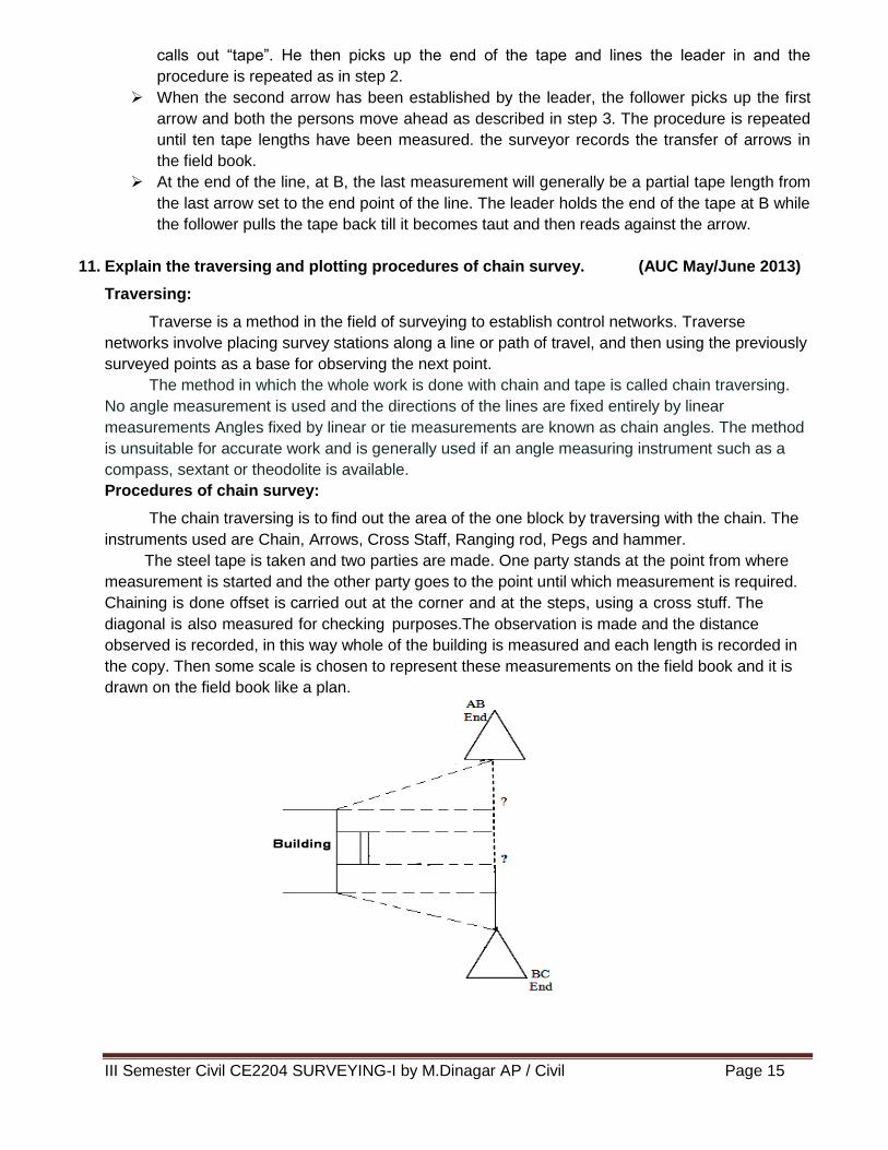
11. Explain the traversing and plotting procedures of chain survey. (AUC May/June 2013)
Traversing:
Traverse is a method in the field of surveying to establish control networks. Traverse
networks involve placing survey stations along a line or path of travel, and then using the previously
surveyed points as a base for observing the next point.
The method in which the whole work is done with chain and tape is called chain traversing.
No angle measurement is used and the directions of the lines are fixed entirely by linear
measurements Angles fixed by linear or tie measurements are known as chain angles. The method
is unsuitable for accurate work and is generally used if an angle measuring instrument such as a
compass, sextant or theodolite is available.
Procedures of chain survey:
The chain traversing is to find out the area of the one block by traversing with the chain. The
instruments used are Chain, Arrows, Cross Staff, Ranging rod, Pegs and hammer.
The steel tape is taken and two parties are made. One party stands at the point from where
measurement is started and the other party goes to the point until which measurement is required.
Chaining is done offset is carried out at the corner and at the steps, using a cross stuff. The
diagonal is also measured for checking purposes.The observation is made and the distance
observed is recorded, in this way whole of the building is measured and each length is recorded in
the copy. Then some scale is chosen to represent these measurements on the field book and it is
drawn on the field book like a plan.
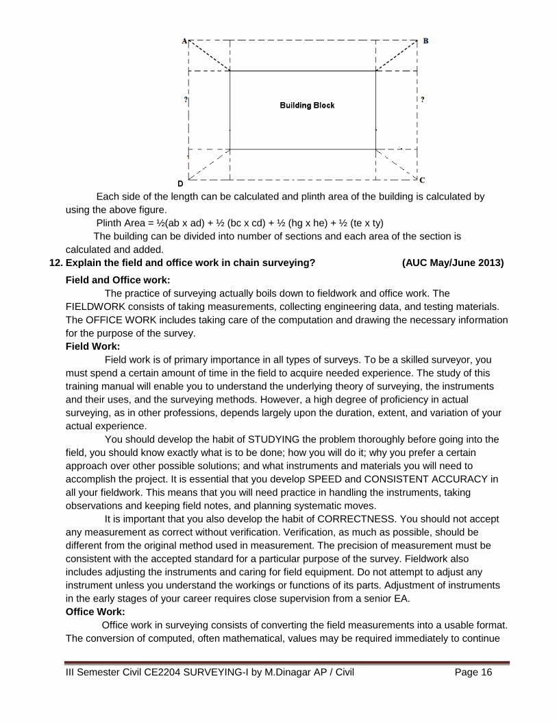
III Semester Civil CE2204 SURVEYING-I by M.Dinagar AP / Civil Page 16
Each side of the length can be calculated and plinth area of the building is calculated by
using the above figure.
Plinth Area = ½(ab x ad) + ½ (bc x cd) + ½ (hg x he) + ½ (te x ty)
The building can be divided into number of sections and each area of the section is
calculated and added.
12. Explain the field and office work in chain surveying? (AUC May/June 2013)
Field and Office work:
The practice of surveying actually boils down to fieldwork and office work. The
FIELDWORK consists of taking measurements, collecting engineering data, and testing materials.
The OFFICE WORK includes taking care of the computation and drawing the necessary information
for the purpose of the survey.
Field Work:
Field work is of primary importance in all types of surveys. To be a skilled surveyor, you
must spend a certain amount of time in the field to acquire needed experience. The study of this
training manual will enable you to understand the underlying theory of surveying, the instruments
and their uses, and the surveying methods. However, a high degree of proficiency in actual
surveying, as in other professions, depends largely upon the duration, extent, and variation of your
actual experience.
You should develop the habit of STUDYING the problem thoroughly before going into the
field, you should know exactly what is to be done; how you will do it; why you prefer a certain
approach over other possible solutions; and what instruments and materials you will need to
accomplish the project. It is essential that you develop SPEED and CONSISTENT ACCURACY in
all your fieldwork. This means that you will need practice in handling the instruments, taking
observations and keeping field notes, and planning systematic moves.
It is important that you also develop the habit of CORRECTNESS. You should not accept
any measurement as correct without verification. Verification, as much as possible, should be
different from the original method used in measurement. The precision of measurement must be
consistent with the accepted standard for a particular purpose of the survey. Fieldwork also
includes adjusting the instruments and caring for field equipment. Do not attempt to adjust any
instrument unless you understand the workings or functions of its parts. Adjustment of instruments
in the early stages of your career requires close supervision from a senior EA.
Office Work:
Office work in surveying consists of converting the field measurements into a usable format.
The conversion of computed, often mathematical, values may be required immediately to continue
III Semester Civil CE2204 SURVEYING-I by M.Dinagar AP / Civil Page 17
the work, or it may be delayed until a series of field measurements is completed. Although these
operations are performed in the field during lapses between measurements, they can also be
considered office work. Such operations are normally done to save time. Special equipment, such
as calculators, conversion tables, and some drafting equipment is used in most office work. In office
work, converting field measurements (also called reducing) involves the process of computing,
adjusting, and applying a standard rule to numerical values.
13. Explain how you will conduct chain survey to measure a land parcel in agriculture field.
(AUC May/June 2013)
Using chaining and ranging the distance between two points can be measured.The instruments required
are chain, arrows, ranging rods, pegs and hammers.
Procedures:
First mark a straight line of a standard length on a flat firm ground. The two end points A and B are
selected on a survey line which is to be measured. A ranging rod is erected at the point B, while
the surveyor stands with another rod at point A. A rod is established at a point in line with AB at a
distance not greater than one chain length from A. The surveyor at A then signals the assistant to
move transverse to the chain line till he is line with A and B. Similarly other intermediate points can
be established. Then by using chain, the distance is measured. To find the pacing length, we
should walk along the chain line and it is found from pacing length.
Pacing length = Distance between the points/No of steps
The distance between two points = (No of arrow x Nominal length +Fractional length) m
The distance between two points can be calculated and also same procedure is used to find
the other side of the line. The finally land parcel of agricultural field is measured.
Precautions: Surface should be smooth and even.
Surveyor must walk in straight line.
Measuring tape must be kept straight and horizontal.
Ranging should be performed for measurements greater than tape length.
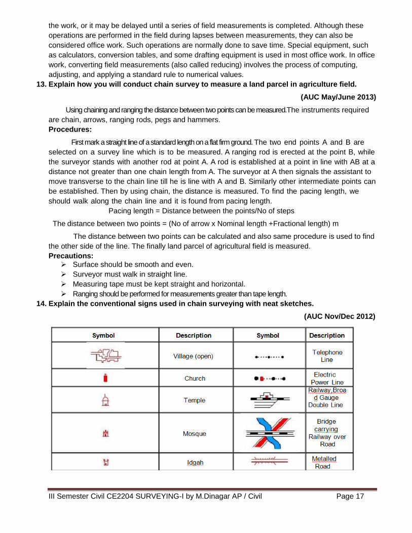
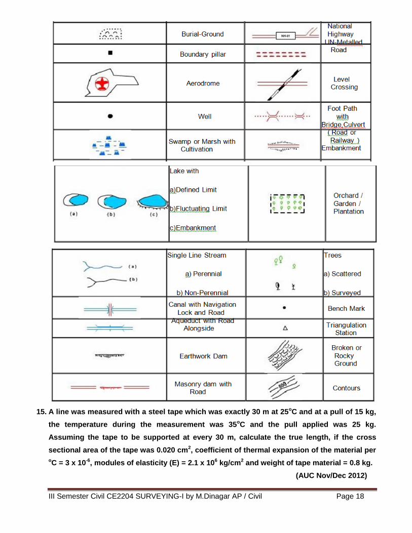
14. Explain the conventional signs used in chain surveying with neat sketches.
(AUC Nov/Dec 2012)
III Semester Civil CE2204 SURVEYING-I by M.Dinagar AP / Civil Page 18
15. A line was measured with a steel tape which was exactly 30 m at 25oC and at a pull of 15 kg,
the temperature during the measurement was 35oC and the pull applied was 25 kg.
Assuming the tape to be supported at every 30 m, calculate the true length, if the cross
sectional area of the tape was 0.020 cm2, coefficient of thermal expansion of the material per
oC = 3 x 10⁻⁶, modules of elasticity (E) = 2.1 x 10⁶ kg/cm2 and weight of tape material = 0.8 kg.
(AUC Nov/Dec 2012)
III Semester Civil CE2204 SURVEYING-I by M.Dinagar AP / Civil Page 19
Solution:
Given:
L = 30 m; T0 = 25oC; Tm = 35oC; Po = 15 kg; P = 25 kg; Area = 0.020 cm2;
W = 0.8 kg; α = 3 x 10⁻⁶; E = 2.1 x 10⁶ kg / cm2
i) Correction for Temperature:
Ct = α (Tm - T0) L
= 3 x 10⁻⁶ (35 – 25) x 30
Ct = 0.0009 m
iii) Correction for Pull:
CP =
AE
LPoP =
6101.202.0
301525
XX
X
CP = 0.00714 m
iv) Sag Correction:
Cs = 22
2
24 Pn
LW =
22
2
25124
8.030
XX
X
Cs = 0.00128 m
Total correction = Ct + CP - Cs
= 0.0009 + 0.00714 – 0.00128
Total correction = 0.00676 m
True length = Length + correction
= 20 + 0.00676
True length = 20.00676 m
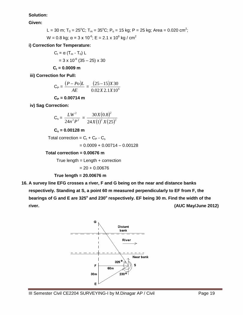
16. A survey line EFG crosses a river, F and G being on the near and distance banks
respectively. Standing at S, a point 60 m measured perpendicularly to EF from F, the
bearings of G and E are 325o and 230o respectively. EF being 30 m. Find the width of the
river. (AUC May/June 2012)
III Semester Civil CE2204 SURVEYING-I by M.Dinagar AP / Civil Page 20
In Δ FSE, FE = 30 m and FS = 60 m
tan ESF = 60
30
ESF = 26O 34’
ESG = 325O – 230O = 95O
FSG = 95O – 26O 34’ = 68O 26’
Now from Δ FSG,
FG = FS tan (68O 26’)
= 60 X tan (68O 26’)
Width of the river, FG = 151.8 m
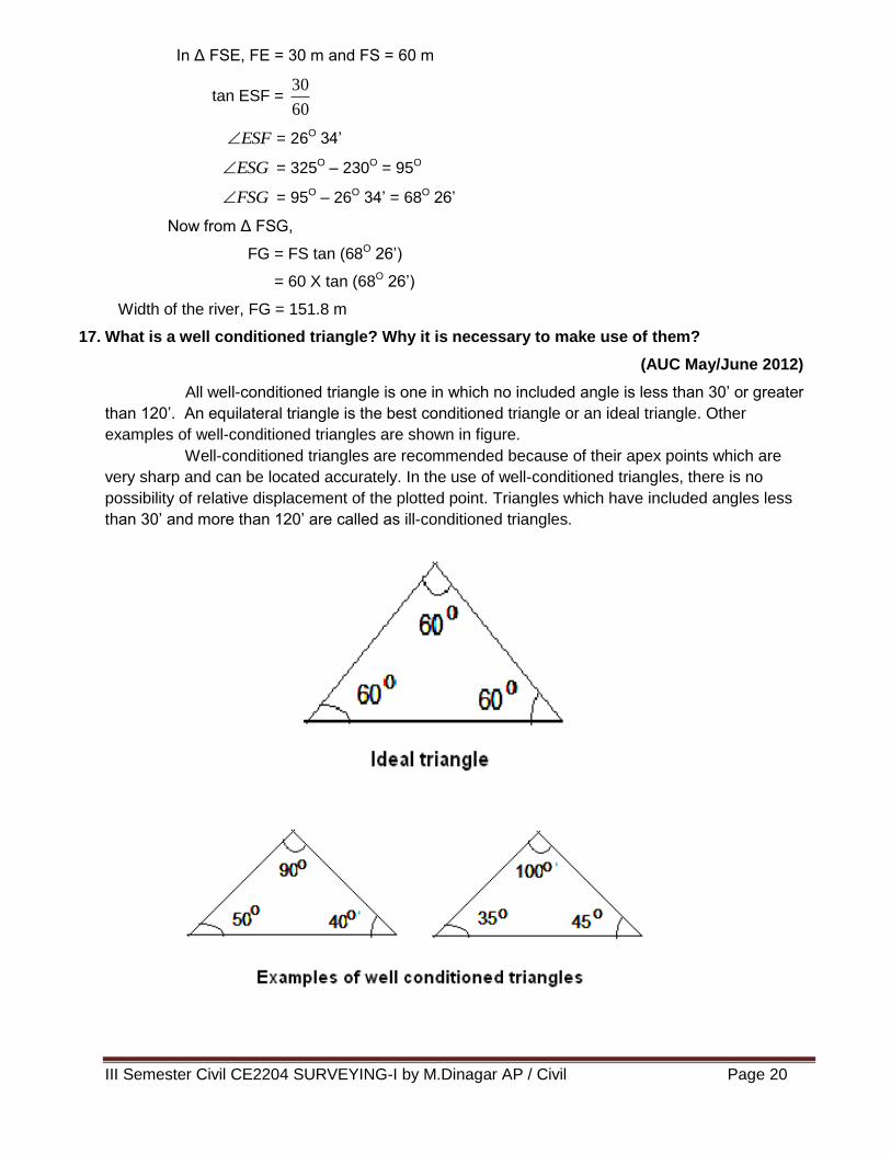
17. What is a well conditioned triangle? Why it is necessary to make use of them?
(AUC May/June 2012)
All well-conditioned triangle is one in which no included angle is less than 30’ or greater
than 120’. An equilateral triangle is the best conditioned triangle or an ideal triangle. Other
examples of well-conditioned triangles are shown in figure.
Well-conditioned triangles are recommended because of their apex points which are
very sharp and can be located accurately. In the use of well-conditioned triangles, there is no
possibility of relative displacement of the plotted point. Triangles which have included angles less
than 30’ and more than 120’ are called as ill-conditioned triangles.
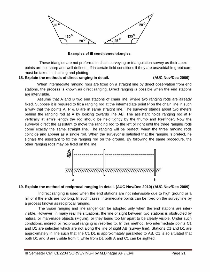
III Semester Civil CE2204 SURVEYING-I by M.Dinagar AP / Civil Page 21
These triangles are not preferred in chain surveying or triangulation survey as their apex
points are not sharp and well defined. If in certain field conditions if they are unavoidable great care
must be taken in chaining and plotting.
18. Explain the methods of direct ranging in detail. (AUC Nov/Dec 2009)
When intermediate ranging rods are fixed on a straight line by direct observation from end
stations, the process is known as direct ranging. Direct ranging is possible when the end stations
are intervisible.
Assume that A and B two end stations of chain line, where two ranging rods are already
fixed. Suppose it is required to fix a ranging rod at the intermediate point P on the chain line in such
a way that the points A, P & B are in same straight line. The surveyor stands about two meters
behind the ranging rod at A by looking towards line AB. The assistant holds ranging rod at P
vertically at arm’s length the rod should be held tightly by the thumb and forefinger. Now the
surveyor direct the assistant to move the ranging rod to the left or right until the three ranging rods
come exactly the same straight line. The ranging will be perfect, when the three ranging rods
coincide and appear as a single rod. When the surveyor is satisfied that the ranging is prefect, he
signals the assistant to fix the ranging rod on the ground. By following the same procedure, the
other ranging rods may be fixed on the line.
19. Explain the method of reciprocal ranging in detail. (AUC Nov/Dec 2010) (AUC Nov/Dec 2009)
Indirect ranging is used when the end stations are not intervisible due to high ground or a
hill or if the ends are too long. In such cases, intermediate points can be fixed on the survey line by
a process known as reciprocal ranging.
The vision ranging and line ranger can be adopted only when the end stations are inter-
visible. However, in many real life situations, the line of sight between two stations is obstructed by
natural or man-made objects (Figure), or they being too far apart to be clearly visible. Under such
conditions, indirect or reciprocal ranging is resorted to. In this method, two intermediate points C1
and D1 are selected which are not along the line of sight AB (survey line). Stations C1 and D1 are
approximately in line such that line C1 D1 is approximately paralleled to AB. C1 is so situated that
both D1 and B are visible from it, while from D1 both A and C1 can be sighted.
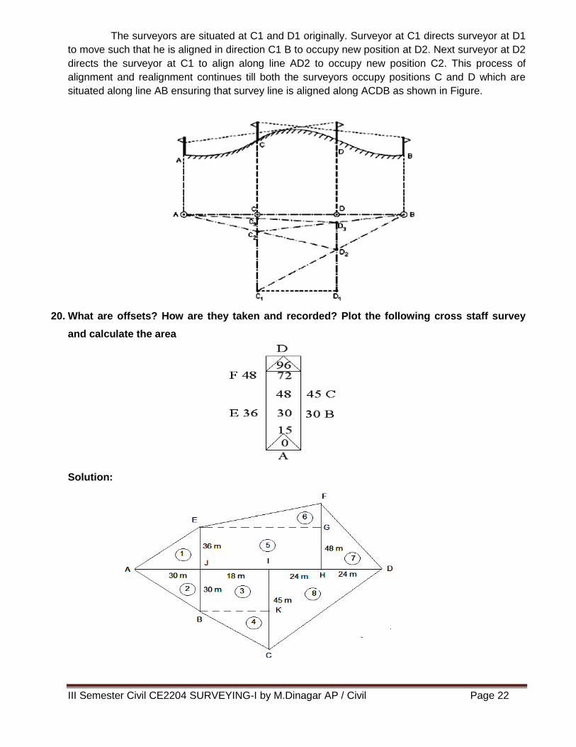
III Semester Civil CE2204 SURVEYING-I by M.Dinagar AP / Civil Page 22
The surveyors are situated at C1 and D1 originally. Surveyor at C1 directs surveyor at D1
to move such that he is aligned in direction C1 B to occupy new position at D2. Next surveyor at D2
directs the surveyor at C1 to align along line AD2 to occupy new position C2. This process of
alignment and realignment continues till both the surveyors occupy positions C and D which are
situated along line AB ensuring that survey line is aligned along ACDB as shown in Figure.
20. What are offsets? How are they taken and recorded? Plot the following cross staff survey
and calculate the area
Solution:
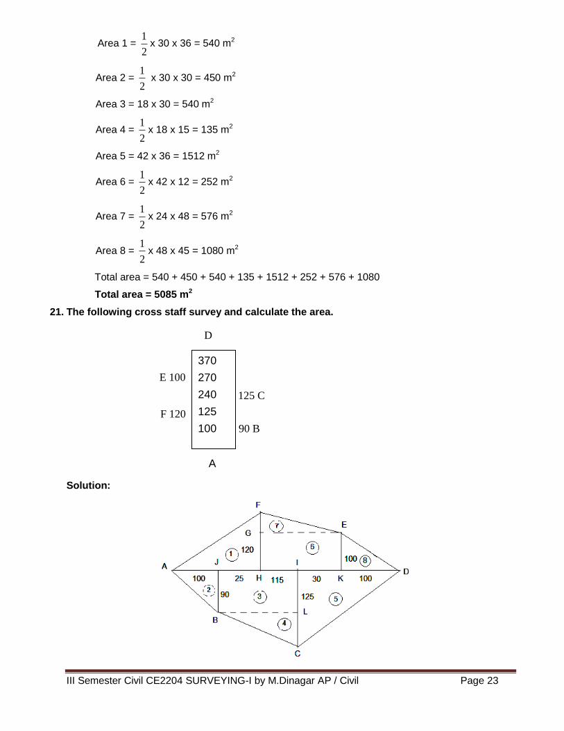
III Semester Civil CE2204 SURVEYING-I by M.Dinagar AP / Civil Page 23
Area 1 = 2
1x 30 x 36 = 540 m2
Area 2 = 2
1 x 30 x 30 = 450 m2
Area 3 = 18 x 30 = 540 m2
Area 4 = 2
1x 18 x 15 = 135 m2
Area 5 = 42 x 36 = 1512 m2
Area 6 = 2
1x 42 x 12 = 252 m2
Area 7 = 2
1x 24 x 48 = 576 m2
Area 8 = 2
1x 48 x 45 = 1080 m2
Total area = 540 + 450 + 540 + 135 + 1512 + 252 + 576 + 1080
Total area = 5085 m2
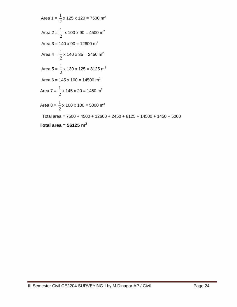
21. The following cross staff survey and calculate the area.
Solution:
370
270
240
125
100
0
E 100
125 C
90 B
F 120
D
A
III Semester Civil CE2204 SURVEYING-I by M.Dinagar AP / Civil Page 24
Area 1 = 2
1x 125 x 120 = 7500 m2
Area 2 = 2
1 x 100 x 90 = 4500 m2
Area 3 = 140 x 90 = 12600 m2
Area 4 = 2
1x 140 x 35 = 2450 m2
Area 5 = 2
1x 130 x 125 = 8125 m2
Area 6 = 145 x 100 = 14500 m2
Area 7 = 2
1x 145 x 20 = 1450 m2
Area 8 = 2
1x 100 x 100 = 5000 m2
Total area = 7500 + 4500 + 12600 + 2450 + 8125 + 14500 + 1450 + 5000
Total area = 56125 m2
Recommended