National Aeronautics and Space Administration
ac
tivity
bo
ok
let
Earth Dayis everyday at NASA

Earth Day is everyday at NASA
NASA’s Fleet of Earth Observing Satellites
Terra GRACE
Aura
ICESat
SORCEAqua
ACRIMSAT
Landsat 7

ac
tivity
bo
ok
let
TRMM
ICESat
EO-1
OSTM/Jason-2
CloudSat
CALIPSO
QuikSCAT
Jason-1

NASA
NASA seeks to understand Earth’s systems and their
response to natural and anthropogenic (human-made)
changes. A fleet of satellites in NASA’s Earth Observing
System (EOS) gives scientists the global, long-term
measurements they need to connect the atmosphere (air),
lithosphere (land), hydrosphere (water), cryosphere (snow/
ice), and biosphere (life) as a single system.
NASA works with many other partners from government,
industry, academia, and international space agencies on
the 15 satellite missions that make up the Earth Observing
System. Each of these satellites gathers a unique set of
measurements for studying Earth. By combining these
measurements, NASA researchers and partners improve
weather forecasts, understand natural disasters, manage
agriculture and forests, and predict how climate will change.
In celebration of Earth Day, NASA invites you to learn more
about the agency’s commitment to understanding our
changing planet by completing the activities in this booklet.
2
Earth Day is everyday at NASA

ac
tivity
bo
ok
let
3
NASA’s Fleet of Earth Observing Satellites
(listed by launch date)
TRMM—Tropical Rainfall Monitoring Mission
TRMM is a joint mission between NASA and the Japan Aerospace Exploration Agency (JAXA). It was designed to monitor and study tropical rainfall and the associated release of energy that helps to power the global atmospheric circulation, shaping both weather and climate around the globe. For more information please visit http://nasascience.nasa.gov/missions/trmm
Landsat 7—Mapping Earth’s Surface
Landsat 7, launched on April 15, 1999, is the latest satellite in the series of Landsat satellites that have been collecting images of Earth’s surface for more than 35 years. A joint initiative of the U.S. Geological Survey (USGS) and NASA, Landsat 7 provides images useful for people working in agriculture, geology, forestry, education, and mapping. For more information please visit http://nasascience.nasa.gov/missions/landsat-7

4
Earth Day is everyday at NASA
QuikSCAT/SeaWinds—Measuring Ocean Winds from Space
NASA’s Quick Scatterometer (QuikSCAT) was launched on June 19, 1999. QuikSCAT’s all-weather, high-resolution measurements of near-surface winds over global oceans are combined with wind data from other instruments to help us better understand global climate change and weather patterns, rain forest vegetation changes, sea ice edge movement and Arctic/Antarctic ice pack changes. For more information please visit http://nasascience.nasa.gov/missions/quikscat
Terra—Measuring the Earth System
NASA’s Terra satellite was launched on December 18, 1999. Terra (previously called EOS AM-1) provided the first global and seasonal measurements of the Earth system—from the atmosphere to the land and ocean, as well as their interactions with solar radiation and with one another. For more information please visit http://nasascience.nasa.gov/missions/terra
ACRIMSAT—Measuring the Sun’s Energy
The Active Cavity Radiometer Irradiance Monitor Satellite (ACRIMSAT) launched on December 20, 1999. ACRIMSAT measures the sun’s total energy output and has shown that the sun’s energy changes on an 11-year cycle. Knowing

ac
tivity
bo
ok
let
5
the amount of energy that the sun delivers to the Earth helps scientists build better models to predict changes in climate. For more information please visit http://nasascience.nasa.gov/missions/acrimsat
EO-1—Earth Observing Mission 1
The EO-1 mission launched on November 21, 2000, as part of the New Millenium Program (NMP). The mission was designed to demonstrate new technologies and strategies for improved Earth observations. For more information please visit http://nasascience.nasa.gov/missions/eo-1
GRACE—Measuring Changes in Earth’s Gravitational Field
The Gravity Recovery and Climate Experiment (GRACE) twin satellites launched on March 17, 2002. As these two satellites fly in formation, they make the most detailed measurements of Earth’s gravity field to date. These new gravity measurements help scientists to measure the changing mass of polar ice caps, observe changes in water resources on land, and understand ocean currents and sea level change. GRACE observations are also useful for understanding the forces that move tectonic plates that often result in earthquakes and volcanic eruptions. For more information please visit http://nasascience.nasa.gov/missions/grace

6
Earth Day is everyday at NASA
Aqua—Measuring Earth’s Water Cycle
NASA’s Aqua satellite was launched on May 4, 2002. Aqua measures all elements of the water cycle (liquid, solid, and vapor forms). It also measures aerosols (airborne particles), vegetation cover on land, microscopic ocean plants called phytoplankton, and temperatures of air, land, and water. Aqua is the first member of the Afternoon Constellation (A-Train)—a group of satellites that fly in formation around Earth. For more information please visit http://nasascience.nasa.gov/missions/aqua
ICESat—Measuring Earth’s Ice Sheets
The Ice, Cloud, and land Elevation Satellite (ICESat), launched on January 12, 2003, is the benchmark EOS mission for measuring ice sheet elevation changes. It also measures properties of polar clouds, aerosol heights, land topography, and vegetation. For more information please visit http://nasascience.nasa.gov/missions/icesat
SORCE—The Solar Radiation and Climate Experiment
SORCE, launched on January 25, 2003, makes state-of-the-art measurements of incoming x-ray, ultraviolet, visible, near-infrared, and total solar radiation. These measurements are important for studying long-term climate change and the effects of solar changes on Earth and humankind. For more information please visit http://nasascience.nasa.gov/missions/sorce

ac
tivity
bo
ok
let
7
Aura—A Mission Dedicated to the Health of Earth’s Atmosphere
On July 15, 2004, NASA launched the Aura satellite. Aura studies Earth’s ozone, air quality, and climate—specifically, the composition, chemistry, and dynamics of the Earth’s upper and lower atmosphere. For more information please visit http://nasascience.nasa.gov/missions/aura
CALIPSO—A Global Perspective of Clouds and Aerosols from Space
The Cloud-Aerosol Lidar and Infrared Pathfinder Satellite Observation (CALIPSO) satellite launched on April 28, 2006. CALIPSO provides scientists with new insight into the role that clouds and atmospheric aerosols play in regulating Earth’s weather, climate, and air quality. For more information please visit http://nasascience.nasa.gov/missions/calipso
CloudSat—Revealing the Inner Secrets of Clouds
CloudSat, launched on April 28, 2006, gives us valuable information on the vertical structure of clouds, the percentage of clouds that produce rain, how much water and ice are in clouds, and how well the atmosphere produces rain from condensation. These data help scientists understand how clouds and aerosols can contribute to atmospheric warming. For more information please visit http://nasascience.nasa.gov/missions/cloudsat
8
Earth Day is everyday at NASA
Jason-1 and OSTM/Jason-2—Ocean Surface Topography Missions
The Ocean Surface Topography Mission on the Jason-2 satellite (OSTM/Jason-2)—launched on June 20, 2008—is a follow-on to the Jason-1 mission (launched December 1, 2001). The Jason missions were launched to extend the measurements of the ocean surface into the 21st century. These measurements increase our understanding of ocean circulation, improve forecasting of climate events such as El Niño, measure global sea-level change, and give offshore industries valuable information about wave height and wind speed. For more information please visit http://nasascience.nasa.gov/missions/jason-1 and http://nasascience.nasa.gov/missions/ostm

ac
tivity
bo
ok
let
9
Activity 1: Match the Mission to Its Measurement
Draw an arrow from each of the three EOS flagship satellites to what it measures. There is more than one correct answer for each.
Terra(morning observations)
Aqua(afternoon observations)
Aura
Aerosols
Ocean temperature
The water cycle
Composition/Chemistry of the atmosphere
Land
Climate
Vegetation cover
Ozone
Phytoplankton
Ocean
Air temperature
Interactions with solar radiation
Air quality
Answers. Terra: Aerosols; Ocean Temperature; The Water Cycle; Composition/Chemistry of the Atmosphere; Land; Climate; Vegetation Cover; Phytoplankton; Ocean; Interactions with solar radiation Aqua: Aerosols; Ocean
Temperature; The Water Cycle; Composition/Chemistry of the Atmosphere; Land; Climate; Vegetation Cover; Phytoplankton; Ocean; Air Temperature; Interactions with solar radiation. Aura: Composition/Chemistry of the
atmosphere; Climate; Ozone; Air quality.

10
Earth Day is everyday at NASA
Activity 2: Crossword Puzzle
Across
3. A visible mass of liquid water droplets suspended in the atmo-sphere above Earth’s surface.
5. The area observed by a satellite as it orbits the Earth.
7. The air surrounding the Earth, described as a series of shells or layers of different characteristics.
9. The totality of water encompass-ing the Earth, comprising all the bodies of water, ice, and water vapor in the atmosphere.
11. An instrument that quantita-tively measures electromagnetic radiation.
Down
1. Made by people or resulting from human activities. Usually used in the context of emissions that are produced as a result of human activities.
2. One millionth of a meter, used to measure wavelengths in the electromagnetic spectrum.
4. The component of the Earth’s surface comprising the rock, soil, and sediments.
6. One of the interrelated com-ponents of the Earth’s system, consisting of frozen water in the form of snow, permanently frozen ground (permafrost), floating ice, and glaciers.
8. A severe tropical storm whose winds exceed 74 mph.
10. A collection of facts, concepts or instructions in a formalized man-ner suitable for communication or processing by human beings or by computer.

ac
tivity
bo
ok
let
11
4
6
2
8
1
3
5
7
9
10
11
Answers. 1. Anthropogenic, 2. Micrometer, 3. Cloud, 4. Lithosphere, 5. Swath, 6. Cryosphere, 7. Atmosphere, 8. Hurricane, 9. Hydrosphere, 10. Data, 11. Radiometer

12
Earth Day is everyday at NASA
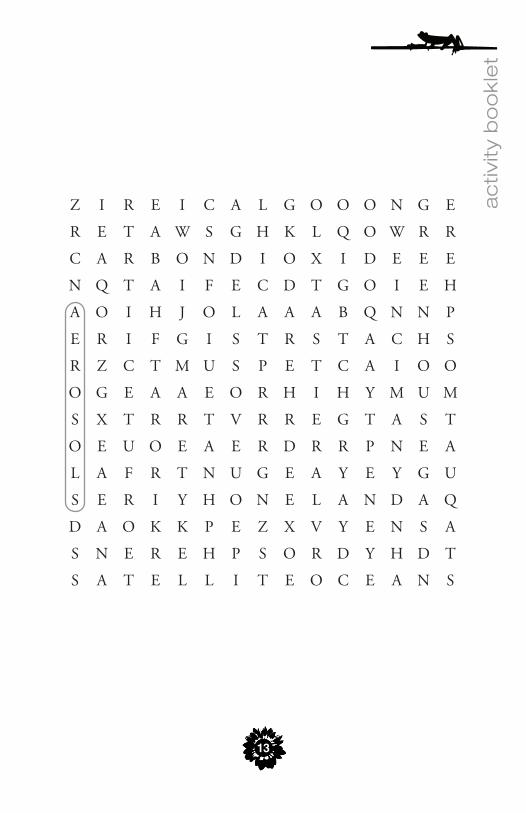
Activity 3: Word Search
✓ AEROSOLSAIRAQUAATMOSPHEREAURABIOSPHERECARBON DIOXIDECLIMATEDATADEFORESTATIONDROUGHTDYNAMICEARTHENERGY
GLACIERGREENHOUSE GASHURRICANEHYDROSPHEREICELANDOBSERVATIONSOCEANSOZONESATELLITETERRAVEGETATIONWATER
ac
tivity
bo
ok
let
13
Z I R E I C A L G O O O N G E
R E T A W S G H K L Q O W R R
C A R B O N D I O X I D E E E
N Q T A I F E C D T G O I E H
A O I H J O L A A A B Q N N P
E R I F G I S T R S T A C H S
R Z C T M U S P E T C A I O O
O G E A A E O R H I H Y M U M
S X T R R T V R R E G T A S T
O E U O E A E R D R R P N E A
L A F R T N U G E A Y E Y G U
S E R I Y H O N E L A N D A Q
D A O K K P E Z X V Y E N S A
S N E R E H P S O R D Y H D T
S A T E L L I T E O C E A N S

14
Earth Day is everyday at NASA
Activity 4: Fill in the Blanks
Choose from the list of words and phrases below to fill in the blanks • terabytes • sunlight • services • TIROS • Earth Sciences Division •
• Earth Observing System • Satellites • space • activities •
NASA recently completed deployment of the 1. , the world’s most advanced and comprehensive capability to measure global climate change.
NASA’s 2. is the largest U.S. federally funded program for studying Earth’s climate and environment.
If we imagine Earth as a vast machine, then 3. is its fuel.
Pioneering the unique vantage point of 4. for studies of Earth was one of the main reasons NASA was created.
In 1960, NASA launched the first weather satellite, named 5. .
measure how clouds interact with sunlight so scientists can 6. estimate how Earth’s energy balance will swing as cloud cover changes.
In a typical year, NASA satellites distribute over 1500 7. of Earth science data—enough to fill a stack of CDs as tall as the Empire State Building.
Observations from NASA’s Earth-observing satellites are used by many 8. agencies to improve the essential services they provide to the nation.
From the vantage point of space we see at continental and planetary 9. scales the vast extent and complexity of human .
Answers. 1. Earth Observing System, 2. Earth Sciences Division, 3. sunlight, 4. space, 5. TIROS, 6. Satellites, 7. terabytes, 8. services, 9. activities

ac
tivity
bo
ok
let
15
Earth Science
Events Calendar
2010
Glory Launch—The Glory mission will increase our under-
standing of the Earth’s energy balance by measuring aerosols
and the total solar irradiance. For more information please
visit http://glory.gsfc.nasa.gov/
Aquarius Launch—The Aquarius mission will enhance the un-
derstanding of the climatic interactions between the global water
cycle and ocean circulation by mapping the spatial and temporal
variations of sea surface salinity. For more information please
visit http://aquarius.nasa.gov/
The National Polar-orbiting Operational Environmental Sat-
ellite System (NPOESS) Preparatory Project (NPP) Launch—
The NPP mission will provide NASA with continuation of a set
of global-change observations initiated by the Earth Observing
System (EOS) Terra, Aqua, and Aura missions. For more infor-
mation please visit http://jointmission.gsfc.nasa.gov/
2012
Landsat Data Continuity Mission (LDCM) Launch— The
LDCM will characterize and monitor land-cover use and change
over time for global climate research, polar studies, land use and
land cover change, and the impacts of natural events as well as
human activities on Earth’s surface. For more information please
visit http://ldcm.nasa.gov/

16
Earth Day is everyday at NASA
The following links provide additional information about NASA’s Earth
Science program
NASA’s Earth Observatory http://earthobservatory.nasa.gov/
NASA Science Mission Directorate - Earth Sciences Division http://nasascience.nasa.gov/earth-science
NASA Earth Science News Features http://www.nasa.gov/topics/earth/index.html
Visible Earth http://visibleearth.nasa.gov/
NASA Earth Observations http://neo.sci.gsfc.nasa.gov/
The Earth Observing System http://eospso.gsfc.nasa.gov/

ac
tivity
bo
ok
let
17
Notes:

National Aeronautics and Space Administration
NASA Headquarters300 E Street SWWashington, DC 20546eos.nasa.gov
www.nasa.gov NP-2009-3-079-GSFC
Recommended