4
DISASTER EARLY WARNING SYSTEM FOR COX'S BAZAR
Prepared for
United Nations Office for Project Services (UNOPS) through Comprehensive Disaster Management Programme (CDMP) under the
Ministry of Food and Disaster Management, Government of the People’s Republic of Bangladesh
Under the Project "Development of a Disaster Preparedness Programme for Earthquake and
Tsunami Hazards in Cox's Bazar Area"
Department of Civil Engineering Bangladesh University of Engineering and Technology (BUET)
Dhaka-1000
5
DISASTER EARLY WARNING SYSTEM FOR COX'S BAZAR
A Report to
Comprehensive Disaster Management Programme (CDMP) Ministry of Food and Disaster Management
Government of the People’s Republic of Bangladesh
Project Director:
Dr. Ashutosh Sutra Dhar Associate Professor, Department of Civil Engineering, BUET
Co-Researcher:
Dr. Mehedi Ahmed Ansary
Professor, Department of Civil Engineering, BUET
Research Assistants:
Rajan Saha A. B. Afifa Imtiaz Kalyani Sutradhar Mahfuza Shamim
June 2008 Department of Civil Engineering
Bangladesh University of Engineering and Technology (BUET) Dhaka-1000
6
Executive Summary Early Warning System is one of the most effective measures for Disaster Preparedness.
Well-functioning of such a system is needed to deliver accurate information dependably and
on-time. It should also be people-centered to empower communities’ preparedness against
natural hazards. Recent series of disasters in Bangladesh and neighboring countries have
posed an added concern on the importance of emergency alerts. In the present research the
existing early warning systems for disasters in Cox’s Bazar district of Bangladesh, especially
the cyclone warning system have been reviewed. A new satellite based warning
dissemination system was then set up across the district. To develop a comprehensive awareness program regarding Earthquake and Tsunami
Hazards, effectiveness of the existing Early Warning Dissemination System of Cyclone
Preparedness Program has been evaluated for its applicability to other natural disasters. Two
sets of questionnaire were developed one for individual level study through Key Information
Interview (KII) and the other for group level evaluation through Rural Rapid Appraisal
(RRA). The Early Warning Dissemination System has been evaluated based on the response
of the local vulnerable groups through these participatory questionnaire surveys. Finally GIS
has been used to determine the location of the existing cyclone shelters, the early warning
systems and their area of coverage. The accessibility of the local people to those shelters was
then examined so that Evacuation Plans for the significant shelter-locations can be prepared. The existing global tsunami warning systems have also been reviewed to identify the key
features of the systems. On the basis of the knowledge accumulated and analyses performed,
the new satellite based early warning system, WorldSpace AREA Solution, has been
procured. Twenty sets of the system have been deployed in Dhaka and Cox’s Bazar on a Pilot
basis. The system is capable of disseminating messages to the community within 10 seconds
after issuing alert. Finally, the technologies and devices proposed for earthquake warning in
some countries has been discussed
7
Acknowledgement
The authors acknowledge the funding of this research project by United Nation Office for
Project Service (UNOPS) through Comprehensive Disaster Management Program (CDMP)
of the Ministry of Disaster Relief and Rehabilitation of Bangladesh Government.
8
TABLE OF CONTENTS
Contents Page No
Executive Summary 4
Acknowledgement 5
Table of Contents 6
List of Figures 8
List of Tables 9
1 Introduction 10
2 Warning System in Bangladesh 11
3 Scope of CPP work 11
4 Warning Equipment and Logistics 12
5 Operational Method 14
6 Signaling System 16
7 Evaluation of Existing Disaster Preparedness System 19
7.1 Overview of Cyclone Shelters 20
7.2 Key Information Interview 22
7.2.1 Development of Questionnaire 22
7.2.2 Participatory Survey 24
7.2.3 Location of the Inhabitants and Shelters 26
7.2.4 Emergency Facilities 30
7.2.5 Live Stock Facilities 30
7.2.6 Early Warning Signals 30
7.2.7 Warning Dissemination System 30
7.2.8 Peoples' Participation in Shelter Management 31
7.2.9 Usefulness of Cyclone Shelters and Effectiveness of Warning Dissemination
32
7.2.10 Applicability to Earthquake and Tsunami Disasters 32
7.3 Rural Rapid Appraisal 32
7.3.1 Development of Questionnaire 33
7.3.2 RRA Data Analysis 35
7.3.3 Local Inhabitants near to the cyclone shelter 37
7.3.4 Initiatives of Local Administration and Other Organization 40
7.3.5 Role of NGO's 41
9
TABLE OF CONTENTS (contd.)
8 Review of Tsunami Warning Systems 41
8.1 Existing Tsunami Warning Systems 42
8.2 Tsunami Warning in Pacific Ocean 43
8.2.1 Pacific Tsunami Warning Centre 43
8.2.2 West Coast and Alaska Tsunami Warning Centre 46
8.2.3 Japan Meteorological Agency 47
8.3 Indian Ocean Tsunami Warning System 50
8.4 Tsunami Warning in North Eastern Atlantic, The Mediterranean and connected seas
51
9 Development of Regional Warning System 52
9.1 Concept of Operations 52
9.2 Community Training 53
9.3 Challenges 53
9.4 Addressable Radio for Emergency Alert (AREA) 55
9.5 Operation 58
9.6 Installation of AREA in Bangladesh 58
10 Earthquake Warning 58
11 Summary 31
REFERENCES 62
APPENDIX A
APPENDIX B
APPENDIX C
10
LIST OF FIGURES Figure 1: CPP Network
Figure 2: BMD's Dissemination Network
Figure 3: Governmental Organizational Chart
Figure 4: Operational Method
Figure 5: CPP Warning System
Figure 6: Volunteer conducting KII
Figure 7: Participants’ response
Figure 8: KII in questionnaire form
Figure 9: Distance of nearest cyclone shelter
Figure 10: Time to reach nearest cyclone shelters
Figure 11: Response of people after getting warning
Figure 12: Volunteer conducting RRA
Figure 13: People’s participation
Figure 14: RRA in paper format
Figure 15: Population near to the cyclone shelter
Figure 16: Warning Dissemination time before cyclone
Figure 17: Understanding the meaning of warning surveyed
Figure 18: Number of roads connecting houses and shelters
Figure 19: Utility of cyclone shelter at the disaster moment
Figure 20: DART Buoy System
Figure 21: Location of DART in the Pacific Ocean
Figure 22: DART Station owners
Figure 23: Observation Network and transmission of Tsunami Warning in Japan
Figure 24: Schematic of WorldSpace Satellite System
Figure 25: AREA –C Configuration
Figure 26: Different Configuration of the AREA solution
Figure 27 Different Types of waves
Figure 28: Earthquake Warning System
11
LIST OF TABLES Table 1: Warning System for Maritime ports
Table 2: Warning system for river ports
Table 3: Meanings of Flag Numbering System
Table 4: Key Information Interview format in Bengali
Table 5: Distribution of Age Groups of People Surveyed
Table 6: Distance of House from Sea shore
Table 7: Distance of the nearest Cyclone Shelter
Table 8: RRA in questionnaire form
Table 9: Population Distribution
Table 10: Role of Local Administration
Table 11: Role of other Organization
Table 12: Role of Govt. Organization
12
1. Introduction Bangladesh is a disaster prone country where many lives are lost and properties are damaged
every year due to natural disasters. The city of Cox's Bazar is located in the south eastern part
of the country which falls in the High Risk Zone for tropical cyclone. Development of a
Cyclone Preparedness Program (CPP) in the country for the area has resulted in a reduction
of loss due to cyclone. However, the earthquake and related tsunami have recently appeared
as additional natural threats to this region.
Natural hazards in Bangladesh are costing millions of Taka in the form of lives lost and
public and private properties destroyed. Many disasters like floods, droughts, cyclones,
earthquakes, tornadoes, struck the country almost every year. In the recent years, earthquakes
and related tsunamis have appeared as most devastating natural disasters in the south and
south-east Asia. Bangladesh also anticipates facing the adverse effects of those disasters. The
country is situated in a moderate earthquake zone. Naturally the country needs to develop a
disaster reduction program as the Nation's commitment to reduce the impacts of hazards and
enhance the safety and economic well being of every individual and community.
Cox's Bazar, located in the south eastern part of Bangladesh, is a strategically and
economically important city of the country. The longest sand beach of the world is located at
Cox's Bazar. However, the area is exposed to most devastating natural disasters of the
country. Cox's Bazar and the nearby area fall in the High Risk Zone for tropical cyclone. The
Multipurpose Cyclone Shelter Program by the Government of Bangladesh in 1993 has
resulted in the development of many cyclone shelters in the area, which has reduced the loss
due to cyclone significantly. However, the earthquake and related tsunamis has recently
appeared as additional threats to this region. Therefore, it is essential to develop an
earthquake and tsunami preparedness program for the region in order to reduce the potential
losses expected from those disasters.
The existing sheltering system and warning mechanism in Cox's Bazar has been evaluated
through participatory methods for their suitability to use for earthquake and tsunami. The
existing shelters were developed in the area as a cyclone preparedness program after the
devastating cyclone in 1991. The Early Warning Dissemination System and the usability of
the cyclone shelters were evaluated on the basis of a questionnaire survey involving the local
community. Aspects of warning mechanism for different types of disaster were then
13
reviewed. Based on the study a satellite based multi hazard warning system has been
introduced in the Cox's Bazar area.
2. Warning System in Bangladesh Bangladesh Meteorological Department (BMD) under the Ministry of Food and Disaster
Management play the key role in generating warning in Bangladesh. Bangladesh
Meteorological Department is responsible for generating warning for all hazards,
disseminating the warning through public media and different preparedness units and to
follow up the warnings at periodic intervals. For dissemination of the warnings BMD uses
existing cyclone warning network. The network was established in 1973 as Cyclone
Preparedness Programme (CPP) which was developed as a joint venture program of
Bangladesh Red Crescent Society (BDRCS) and the Ministry of Food and Disaster
Management and the Government of Bangladesh. CPP (Cyclone Preparedness Programme)
and BMD (Bangladesh Meteorological Department) mainly work together for disaster
warning generation and dissemination of the warning to the root level people in Bangladesh.
3. Scope of CPP work Cyclone preparedness Program was developed with a goal to develop and strengthen the
disaster preparedness response capacity of coastal communities vulnerable to cyclones, to
increase the efficiency of volunteers and officers, and to maintain and strengthen the warning
system ensuring effective response in the event of a cyclone. In order to achieve the goal,
CPP is involved with number of pre-disaster, during disaster and post-disaster activities.
The following main activities of the program are being implemented to fulfill the objectives
of the Cyclone Preparedness program:
1. Disseminate cyclone warning signals issued by the Bangladesh
Meteorological department to the community people.
2. Assist people in taking shelter.
3. Rescue distressed people affected by a cyclone.
4. Provide First Aid to the people injured by a cyclone.
5. Assist in relief and rehabilitation operations.
14
6. Assist in the implementation of the BDRCS Disaster Preparedness
Plan.
7. Assist in participatory community capacity build-up activities.
8. Assist in the co-ordination of disaster management and development
activities.
4. Warning Equipment and logistics
a. Warning Equipment:
As discussed earlier, Bangladesh Meteorological Department is primarily responsible for
generating warnings for hazards which is disseminated to the vulnerable community through
the administrative network of Bangladesh Government along with the infrastructure of the
Bangladesh Red Crescent Society where CPP is a project of the BDRCS. BDRCS and the
CPP units receive messages of warning from BMD through high frequency satellite radio.
The unit Team Leaders of CPP is provided with a transistor radio for receiving the messages.
CPP then disseminate the warning signals among the villagers through megaphones, sirens,
public address equipment, signal lights etc. Signal flags are also provided to each volunteer's
teams where number of flags on a mast indicates the severity of the event.
b. Volunteers' Gears
To facilitate the Volunteers movement in the adverse weather, they are provided with rain
coats, gum boots, hardhats, life jackets and torch lights. Besides these, the first aid and rescue
Volunteers are provided with first aid and rescue kits.
c. Telecommunication Network:
The Cyclone Preparedness Programme operates an extensive network of Radio
communications facilities, in the coastal areas, linked to its Head Quarter (Head Quarter of
BDRCS) at Dhaka. The network consists of a combination of High Frequency and Very High
Frequency radios, which covers most of the high risk cyclone areas.
15
The telecommunication network of the Cyclone Preparedness Programme is composed of
three elements as follows:
a) High Frequency (HF) Transceiver Radio:
- With a main base station located at the Dhaka Headquarter
- To transmit information related to the cyclone and the preparedness.
- Field stations send the progress and effects of the cyclone to the
headquarter
b) Very High Frequency (VHF) Transceivers:
- To receive and transmit messages from HF field stations to Sub-Stations
locate at Union/Islands.
c) Transistor Radio:
- Used by each unit Team leader (2760 teams)
- Receive Meteorological information, cyclone warning signal and special
Weather transmitted by Radio Bangladesh on regular basis.
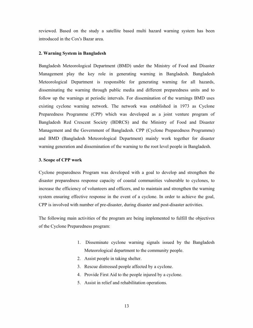
CPP operates a total of 142 Radio stations, among those 64 stations are placed in cyclone
shelters, built by the BDRCS, in the high risk cyclone prone areas (CPP, BDRCS, 2002).
These radio stations are powered by solar panels and also storage battery. 26 stations have
both HF and VHF Radio transceivers operating, and 10 stations where only HF Radio
transceivers operating. Only VHF Radio transceivers are located and in operation in 106
stations. Figure 1 shows CPP Network in Cox's Bazar District.
Figure 1: CPP Network (CPP, BDRCS, 2002)
16
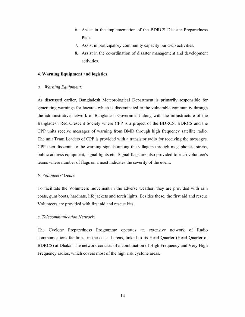
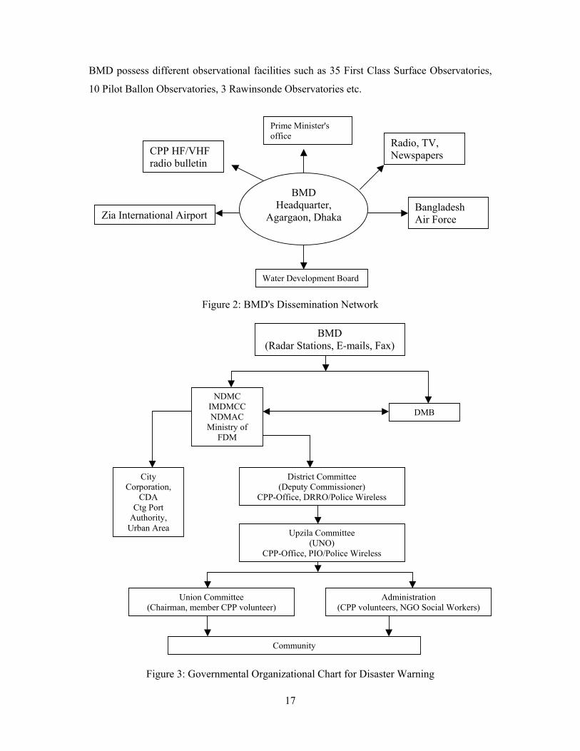
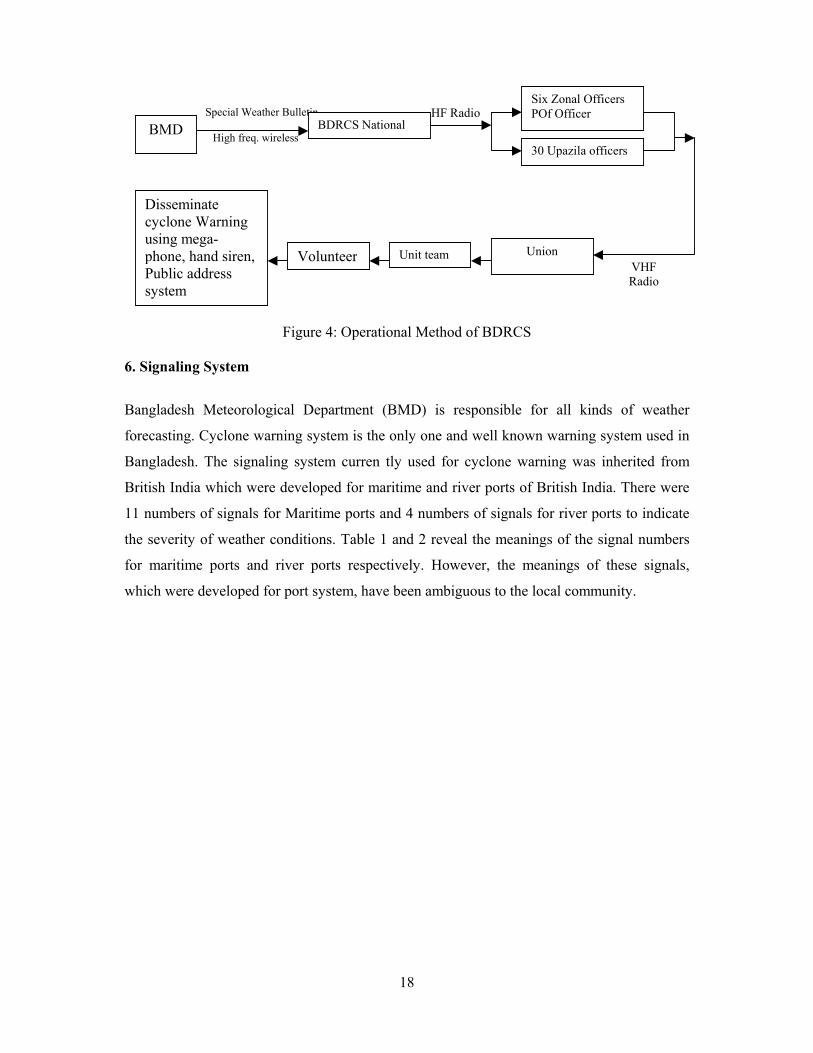
5. Operational Method
BMD monitors hazard around the country round the clock and disseminate warning through
the organizational network of Bangladesh Government and BDRCS. Figure 2 shows the
BMD's dissemination network. Different institution of Bangladesh government is
immediately informed about the disaster. The institutions of the government then participate
on the dissemination through its organization network. Figure 3 shows the organizational
chart of Bangladesh government that reveals how the warning is disseminated to the local
community through the governmental network. Information directly to CPP from BMD also
acts parallel. Figure 4 shows operational method of CPP through BMD. BMD is responsible
for:
- Observing different meteorological parameters both for surface and upper
air all over Bangladesh round the clock.
- Preparing and analyzing all weather charts and to make interpretation on
the basis of analyses.
- Providing weather forecasts for public, farmers, mariners and aviators on
routine basis and also to issue warnings for severe weather phenomena
such as tropical cyclones, tornadoes, nor'swesters, heavy rainfall, etc.
- Maintaining surveillance of weather radars for probing impending tropical
cyclones, nor'swesters and tornadoes.
- exchanging meteorological data, forecasts and warnings to meet national
and international requirements
- Receiving round the clock satellite imageries for timely use in operational
meteorology.
- Extracting maintain quality control, process, archive and publish climatic
data for use of various interested agencies at home and abroad.
- Providing meteorological data, radar echoes and Satellite imageries and
weather forecast for flood forecasting and warning centre.
- Monitoring micro seismic events and earthquake round the clock.
- Conducting special studies required for the policy makers and for the
development of Hydrometeorology and Meteorological sciences in the
region.
17
BMD possess different observational facilities such as 35 First Class Surface Observatories,
10 Pilot Ballon Observatories, 3 Rawinsonde Observatories etc.
Figure 2: BMD's Dissemination Network
Figure 3: Governmental Organizational Chart for Disaster Warning
Prime Minister's office
Water Development Board
Zia International Airport
Radio, TV, Newspapers
Bangladesh Air Force
CPP HF/VHF radio bulletin
BMD Headquarter,
Agargaon, Dhaka
BMD (Radar Stations, E-mails, Fax)
NDMC IMDMCC NDMAC
Ministry of FDM
DMB
City Corporation,
CDA Ctg Port
Authority, Urban Area
District Committee (Deputy Commissioner)
CPP-Office, DRRO/Police Wireless
Community
Union Committee (Chairman, member CPP volunteer)
Administration (CPP volunteers, NGO Social Workers)
District Committee (Deputy Commissioner)
CPP-Office, DRRO/Police Wireless
Upzila Committee (UNO)
CPP-Office, PIO/Police Wireless
18
Figure 4: Operational Method of BDRCS
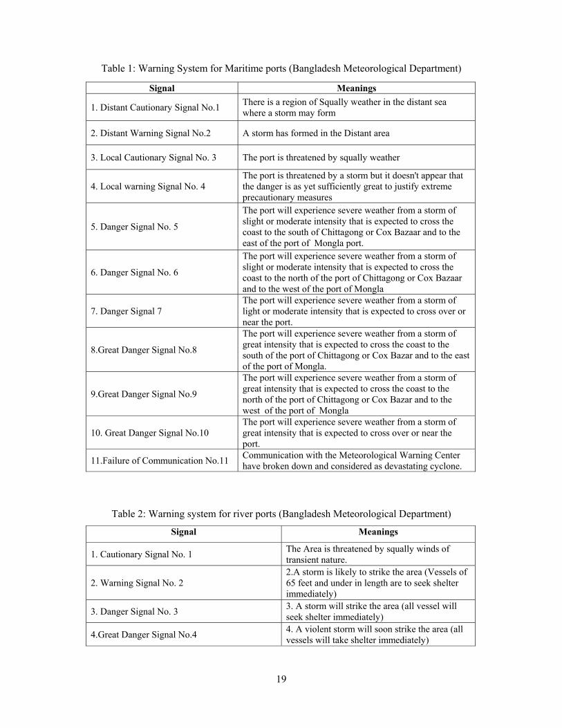
6. Signaling System
Bangladesh Meteorological Department (BMD) is responsible for all kinds of weather
forecasting. Cyclone warning system is the only one and well known warning system used in
Bangladesh. The signaling system curren tly used for cyclone warning was inherited from
British India which were developed for maritime and river ports of British India. There were
11 numbers of signals for Maritime ports and 4 numbers of signals for river ports to indicate
the severity of weather conditions. Table 1 and 2 reveal the meanings of the signal numbers
for maritime ports and river ports respectively. However, the meanings of these signals,
which were developed for port system, have been ambiguous to the local community.
VHF Radio
Special Weather Bulletin
High freq. wireless HF Radio
BMD BDRCS National
Six Zonal Officers POf Officer
30 Upazila officers
Union Unit team Volunteer
Disseminate cyclone Warning using mega-phone, hand siren, Public address system
19
Table 1: Warning System for Maritime ports (Bangladesh Meteorological Department)
Signal Meanings
1. Distant Cautionary Signal No.1 There is a region of Squally weather in the distant sea where a storm may form
2. Distant Warning Signal No.2 A storm has formed in the Distant area
3. Local Cautionary Signal No. 3 The port is threatened by squally weather
4. Local warning Signal No. 4 The port is threatened by a storm but it doesn't appear that the danger is as yet sufficiently great to justify extreme precautionary measures
5. Danger Signal No. 5
The port will experience severe weather from a storm of slight or moderate intensity that is expected to cross the coast to the south of Chittagong or Cox Bazaar and to the east of the port of Mongla port.
6. Danger Signal No. 6
The port will experience severe weather from a storm of slight or moderate intensity that is expected to cross the coast to the north of the port of Chittagong or Cox Bazaar and to the west of the port of Mongla
7. Danger Signal 7 The port will experience severe weather from a storm of light or moderate intensity that is expected to cross over or near the port.
8.Great Danger Signal No.8
The port will experience severe weather from a storm of great intensity that is expected to cross the coast to the south of the port of Chittagong or Cox Bazar and to the east of the port of Mongla.
9.Great Danger Signal No.9
The port will experience severe weather from a storm of great intensity that is expected to cross the coast to the north of the port of Chittagong or Cox Bazar and to the west of the port of Mongla
10. Great Danger Signal No.10 The port will experience severe weather from a storm of great intensity that is expected to cross over or near the port.
11.Failure of Communication No.11 Communication with the Meteorological Warning Center have broken down and considered as devastating cyclone.
Table 2: Warning system for river ports (Bangladesh Meteorological Department)
Signal Meanings
1. Cautionary Signal No. 1 The Area is threatened by squally winds of transient nature.
2. Warning Signal No. 2 2.A storm is likely to strike the area (Vessels of 65 feet and under in length are to seek shelter immediately)
3. Danger Signal No. 3 3. A storm will strike the area (all vessel will seek shelter immediately)
4.Great Danger Signal No.4 4. A violent storm will soon strike the area (all vessels will take shelter immediately)
20
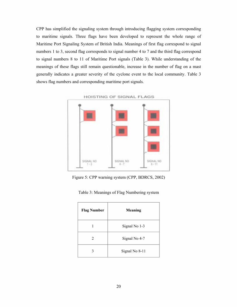
CPP has simplified the signaling system through introducing flagging system corresponding
to maritime signals. Three flags have been developed to represent the whole range of
Maritime Port Signaling System of British India. Meanings of first flag correspond to signal
numbers 1 to 3, second flag corresponds to signal number 4 to 7 and the third flag correspond
to signal numbers 8 to 11 of Maritime Port signals (Table 3). While understanding of the
meanings of these flags still remain questionable, increase in the number of flag on a mast
generally indicates a greater severity of the cyclone event to the local community. Table 3
shows flag numbers and corresponding maritime port signals.
Figure 5: CPP warning system (CPP, BDRCS, 2002)
Table 3: Meanings of Flag Numbering system
Flag Number Meaning
1 Signal No 1-3
2 Signal No 4-7
3 Signal No 8-11
21
7. Evaluation of Existing Disaster Preparedness System Cox’s Bazar is situated in the southeastern part of Bangladesh, beside the Bay of Bengal. It is
a coastal district and famous for its natural beauty and as a tourist place. It was established as
a district in the year 1984. The district consists of 8 Upazilas namely Cox’s Bazar Sadar,
Kutubdia, Maheshkhali, Ramu, Teknaf, Ukhia, Chokoria and Pekua. According to the
parameters of Land based zonation of Coastal Region, all these Upazilas are under Exposed
Coastal Area. One fourth of the district is island and the major ones are Kutubdia,
Maheshkhali, Saint Martin and Shonadia. The district is very much disaster prone. Cyclone,
Tidal Surge, Flash Flood, Earthquake is very common here. From the year 1960 to 1995,
seven major cyclones hit the district. The most devastating cyclone of the last century hit
Cox’s Bazar on November 1970. In 1991, another deadly cyclone hit there. People live on
agricultural work, fishing in the sea, and salt cultivation. Many people are engaged in tourism
and hotel business. The literacy rate in Cox’s Bazar is the least among other coastal districts.
Disaster management preparedness along the coastal belts and in offshore areas is in a poor
shape as there are not enough cyclone shelters in the region. Following cyclones in the 1960s,
a plan was taken to build cyclone shelters for the people living along the coastal region.
Staggering loss of about half a million lives in the calamity on November 12, 1970 fuelled
the demand for the construction of cyclone shelters. Nearly 238 cyclone shelters were built
along the coastal belt between 1972 and 1992. After the cyclone in 1991, in which about
140,000 people were killed, the government constituted a committee to assess the safety
measures of the coastal people. The committee suggested construction of at least 3,500
cyclone shelters in this region to accommodate people during the time of tidal surges,
cyclone, flood and other types of hazards. But 1,841 cyclone shelters have been built so far to
house about 10 per cent of the total coastal population. There are about 1.76 million people
living in Cox’s Bazar District (B.B.S. 2001), vulnerable to cyclones, tidal surges and other
natural calamities. There are 455 cyclone shelters in different places of the district (L.G.E.D.
2003). These are used for sheltering people during the cyclones and are used as schools or
food storage at normal times. They can accommodate 52% of the population. The rest of the
people are left to face the onslaught of hostile weather.
Most of the shelters of the area were built after the 1991 cyclone with the help of Donor
countries and agencies where Saudi Cyclone grant has the prominent share and European
Commission, IFAD grant, World Vision, Japan, BRAC, Red Crescent Society are the other
22
significant contributors. All the shelters belong to the government of Bangladesh except
NGO-owned ones.
The Early Warning Dissemination System and the usability of the cyclone shelters were
evaluated on the basis of a questionnaire survey involving the local community. Two sets of
questionnaire were developed, one for individual level study thru Key Information Interview
(KII) and the other for group level evaluation through Rural Rapid Appraisal (RRA).
7.1 Overview of Cyclone Shelters The existing cyclone shelters are usually two to three storied keeping the Ground Floor
totally open. Stairway is attached within the building. Saudi Grant cyclone building has two
stairways, which facilitates entrance at the time of emergency. There are also attached toilets
but no provision of water supply facility exists in the building.
The physical condition of the shelters is quite good so far as their ages range within 12 to 15
years. There are few cases where cracks, damping, broken doors and windows can also be
seen. As the Shelters are being used mainly as primary schools, the teachers and other staffs
of the school also take care of the building. It has been observed that the buildings with good
outlook attract small children and motivate the parents to send their children to school.
Moreover, strong-looking buildings give mental strength and feeling of safety to the local
people. On an average every shelter is capable of accommodating 1000 to 1200 people at
disaster period. At the crisis moment the crowd that gathers in a shelter makes very unhealthy
condition there. Due to lack of proper ventilation, light, water supply and sanitation facilities
along with lack of sufficient space cause great sufferings.
The problem of access for women is also very important. There is no allocation of separate
space for male and female in any cyclone shelter which is also another major problem as
Cox’s Bazar area is religiously conservative enough to maintain distinction between male and
female. When cyclone shelters are used for exclusively male activities (mosques or
madrasahs in particular) women do not believe themselves to have sanctioned access and will
not enter. Women fear for their safety en route to the shelters. This condition demotivates the
women to take shelter. Again most of the times the women feel very insecure and vulnerable
in the mass where there is also possibility of physical assault. After a devastating cyclone in
1991 which left almost 140,000 people dead, a study carried out by the Red Crescent and
23
other organizations, revealed that 90% of the victims were women and children. Despite the
existence of some cyclone shelters, the communities living around them were not aware of
their purpose or didn't feel it was safe to take refuge in them.
Where the land for the shelter donated, issues of access and ownership of shelter arise which
limit their effectiveness. Social conflicts may erupt when people have to cross land owned by
people inadequately compensated when the land was acquired. The owners of the land where
the shelter was built always has a strong influence and tries to take extra advantages from the
building and obstacle the entrance of general people. Access to shelters is dominated by the
elites and inactive shelter management committees. Minority groups and others may not be
granted entry and at the same time, religious centers of minority groups are often not open to
outsiders. Besides this, people are discriminated on the basis of their economic condition
which sometimes acts as a discouragement for the rich people to take shelter with the general
mass.
The absence of connecting road to the shelter also discourages the families to move to shelter.
On the other hand the evacuation order disseminates in such a time that it becomes difficult to
cross the road and reach the shelter with children and female in a real bad weather.
By the order of Bangladesh government, UNO (Upazila Nirbahi Officer) has the authority of
all these shelters and perform its entire works through Union Disaster Management
Committee. In practice, Union Disaster Management Committee does not play any effective
role in shelter management works.
According to the government order Upazila Disaster Management Committee (UzDMC) has
the responsibility of the entire repair and maintenance works of cyclone shelters. Though
there is a provision of financial support from the authorized Ministry, but in practice they do
not response to the requirements of UzDMC.
24
7.2 Key Information Interview
7.2.1 Development of Questionnaire
Objective of the KII survey was to evaluate the effectiveness of the cyclone shelters from the
view point of individuals of the local community and hence to examine the potentiality of
using those shelters for earthquake and tsunami disasters. For earthquake and tsunami
disasters, major concern is the time to reach the shelter after receiving of the warning, since
the time lag between tsunami appearance and recognition of tsunamigenic earthquake is
expected to be less. Thus, the issues of warning mechanism, time for warning and
evacuation, medium used etc were focused during development of questionnaires.
The questionnaires were developed in such a manner so that they become useful tools to
judge the involvement of the community in sheltering and warning systems of the study area.
To assess the condition of the cyclone shelters, questions of the survey was developed on the
basis of the following considerations,
• Security condition of the shelters
• Sustainability
• Capacity
• Comfortability
• Accessibility
• Connectivity
Table 4 shows a sample questionnaire developed for the participatory survey with the
questions asked.
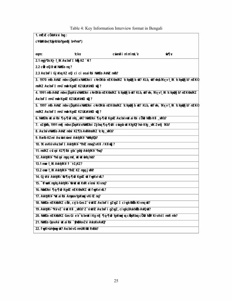
25
Table 4: Key Information Interview format in Bengali 1. mv¶vZ cÖ vbKvixi bvg :
c~Y© wVKvbv (†Uwj‡dvb/†gvevBj b¤^imn*)
eqm : †ckv: cwiev‡ii m`m¨ msL¨v: wk¶v:
2.1 mgy ª DcK~j †_‡K Avcbv‡`I MÖvg KZ ~‡i?
2.2 cÖwZ eQiB wK N~wY©So nq ?
2.3 Avcbv‡`i GjvKvq KZ eQi ci ci eoai‡bi N~wY©So AvNvZ nv‡b?
3. 1970 m‡b AvNvZ nvbv cÖjqsKix N~wY©S‡oii c~‡e© †Kvb mZK© ms‡KZ †c‡qwQ‡jb wK? KLb, wKfv‡e&, †Kv_v †_‡K †c‡qwQ‡jb? mZK©
ms‡KZ Avcbv‡`I m¤ú`nvwb Kgv‡Z KZUzKz Kvh©Ki wQj?
4. 1991 m‡b AvNvZ nvbv cÖjqsKvix N~wY©S‡oi c~‡e© †Kvb mZK© ms‡KZ †c‡qwQ‡jb wK? KLb, wKfv‡e, †Kv_v †_‡K †c‡qwQ‡jb? mZK© ms‡KZ
Avcbv‡`I m¤ú`nvwb Kgv‡Z KZUzKz Kvh©Ki wQj?
5. 1997 m‡b AvNvZ nvbv cÖjqsKvix N~wY©S‡oi c~‡e© †Kvb mZK© ms‡KZ †c‡qwQ‡jb wK? KLb, wKfv‡e, †Kv_v †_‡K †c‡qwQ‡jb? mZK©
ms‡KZ Avcbv‡`I m¤ú`nvwb Kgv‡Z KZUzKz Kvh©Ki wQj?
6. N~wY©S‡o wK ai‡bi ¶q-¶wZ n‡q _v‡K? N~wY©S‡oi ¶q-¶wZ Kgv‡Z Avcbviv wK ai‡bi cÖ ‘wZ MÖnb K‡i _v‡Kb?
7. eZ©gv‡b, 1991 mv‡j nvbv cÖjqsKvix N~wY©S‡oi Zzjbvq ¶q-¶wZi cwigvb wK K‡g‡Q? hw` K‡g _v‡K Zvn‡j †Kb?
8. Avcbviv N~wY©So AvNvZ nvbvi KZ¶b Av‡M ms‡KZ †c‡q _v‡Kb?
9. Rxe‡b KZevi Avcwb/cwievi Avkªq‡K‡› ª wM‡q‡Qb?
10. †K ev Kviv Avcbv‡`I Avkªq‡K‡›`ª †h‡Z mnvqZv K‡i / K‡iwQj?
11. ms‡KZ cvIqvi KZ¶‡bi g‡a¨ gvbyl Avkªq‡K‡› ª hvq?
12. Avkªq‡K‡›`ª hvIqvi mgq mv‡_ wK wK wb‡q hvb?
13.1 evwo †_‡K Avkªq‡K‡›`ªi `~iZ¡ KZ?
13.2 evwo †_‡K Avkªq‡K‡› ª †h‡Z KZ mgq jv‡M?
14. GjvKvi Avkªq‡K›`ªwU ¶q-¶wZ Kgv‡Z wK f~wgKv iv‡L?
15. ¯^vfvweK mg‡q Avkªq‡K›`ªwU wK wK Kv‡R e¨envi Kiv nq?
16. N~wb©S‡oi ¶q-¶wZ Kgv‡Z mZK© ms‡KZ wK f~wgKv iv‡L?
17. Avkªq‡K‡›`ª wK ai‡bi Amyweav †gvKvwejv Ki‡Z nq?
18. N~wY©So mZK©ms‡KZ cÖPvi, cvjb Ges Z`viwK‡Z Avcbv‡`i gZvgZ I civgk© MÖnb Kiv nq wK?
19. Avkªq‡K›`ª Kviv Z`viwK K‡i _v‡Kb? Z`viwK‡Z Avcbv‡`i gZvgZ, civgk©, AskMÖnb Av‡Q wK?
20. N~wY©So mZK©ms‡KZ Ges Gi e¨e¯’vcbv wK iKg n‡j ¶q-¶wZ †gvKvwejvq cÖ‡qvRbxq cÖ¯‘wZ MÖnY Kiv AviI mnR n‡e?
21. N~wY©So Qvov Avi wK ai‡bi `y‡h©vM ev Zvi AvksKv Av‡Q?
22. f~wgK¤ú/mybvwg wK? Avcbviv G m¤ú‡K© wK Rv‡bb?
26
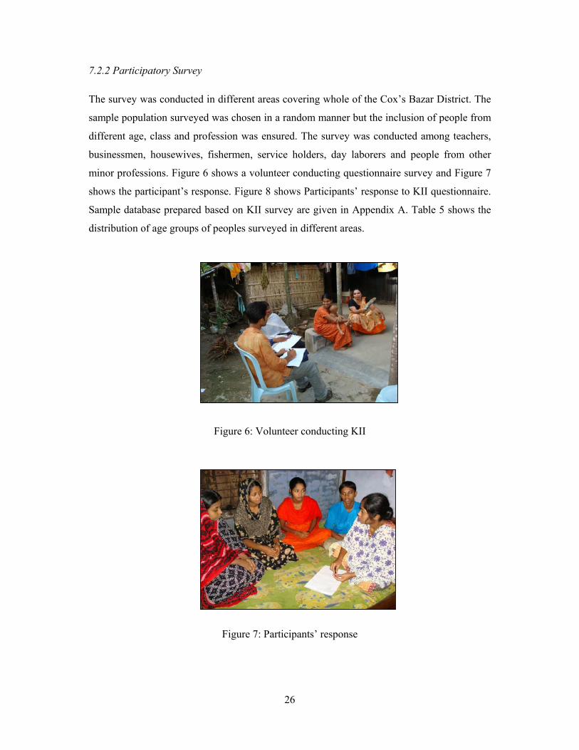
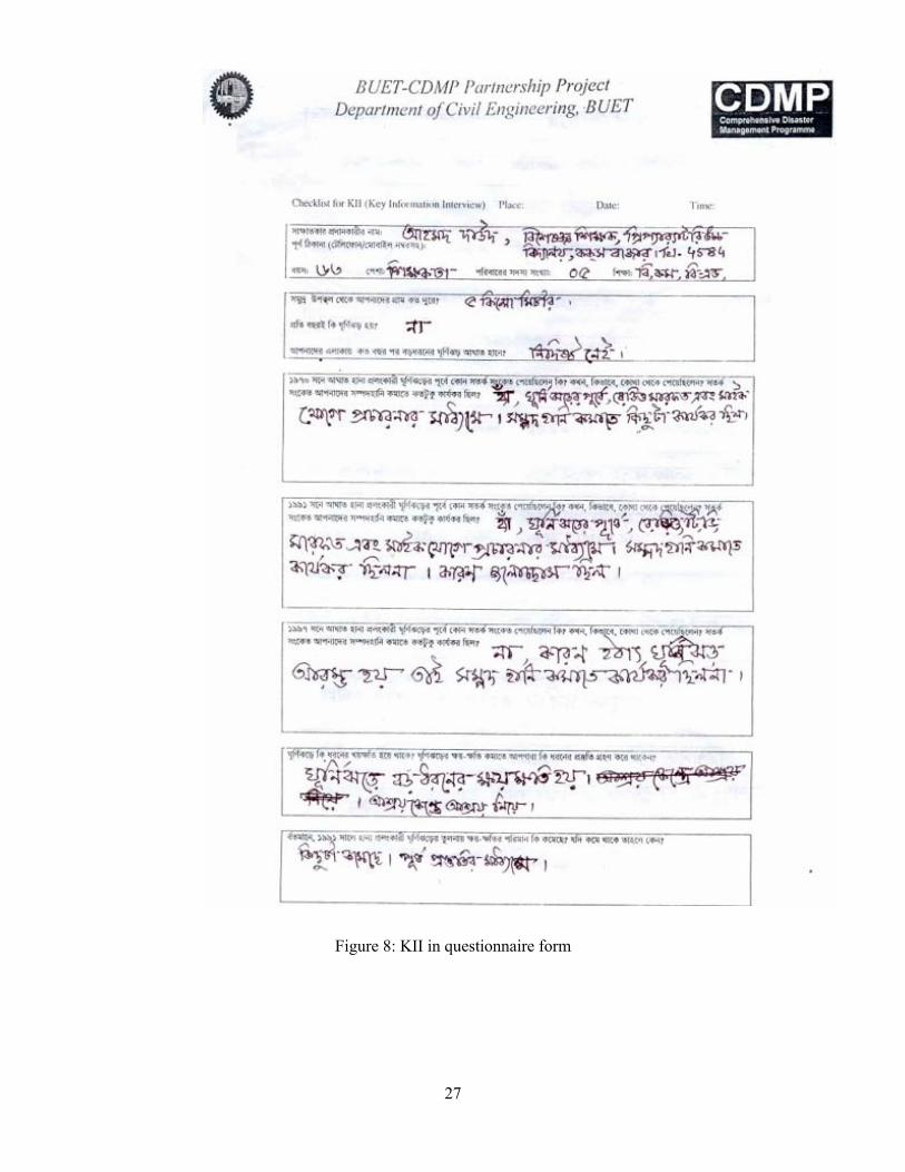
7.2.2 Participatory Survey The survey was conducted in different areas covering whole of the Cox’s Bazar District. The
sample population surveyed was chosen in a random manner but the inclusion of people from
different age, class and profession was ensured. The survey was conducted among teachers,
businessmen, housewives, fishermen, service holders, day laborers and people from other
minor professions. Figure 6 shows a volunteer conducting questionnaire survey and Figure 7
shows the participant’s response. Figure 8 shows Participants’ response to KII questionnaire.
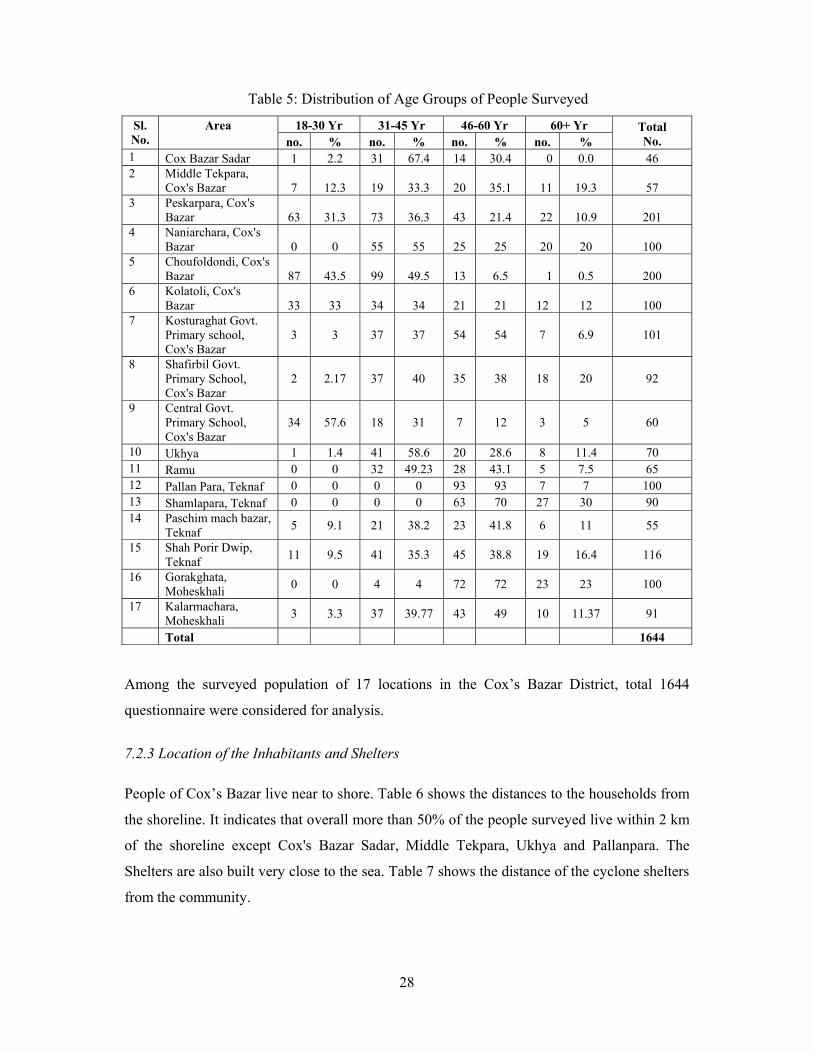
Sample database prepared based on KII survey are given in Appendix A. Table 5 shows the
distribution of age groups of peoples surveyed in different areas.
Figure 6: Volunteer conducting KII
Figure 7: Participants’ response
27
Figure 8: KII in questionnaire form
28
Table 5: Distribution of Age Groups of People Surveyed
18-30 Yr 31-45 Yr 46-60 Yr 60+ Yr Sl. No.
Area no. % no. % no. % no. %
Total No.
1 Cox Bazar Sadar 1 2.2 31 67.4 14 30.4 0 0.0 46 2 Middle Tekpara,
Cox's Bazar 7 12.3 19 33.3 20 35.1 11 19.3 57 3 Peskarpara, Cox's
Bazar 63 31.3 73 36.3 43 21.4 22 10.9 201 4 Naniarchara, Cox's
Bazar 0 0 55 55 25 25 20 20 100 5 Choufoldondi, Cox's
Bazar 87 43.5 99 49.5 13 6.5 1 0.5 200 6 Kolatoli, Cox's
Bazar 33 33 34 34 21 21 12 12 100 7 Kosturaghat Govt.
Primary school, Cox's Bazar
3 3 37 37 54 54 7 6.9 101
8 Shafirbil Govt. Primary School, Cox's Bazar
2 2.17 37 40 35 38 18 20 92
9 Central Govt. Primary School, Cox's Bazar
34 57.6 18 31 7 12 3 5 60
10 Ukhya 1 1.4 41 58.6 20 28.6 8 11.4 70 11 Ramu 0 0 32 49.23 28 43.1 5 7.5 65 12 Pallan Para, Teknaf 0 0 0 0 93 93 7 7 100 13 Shamlapara, Teknaf 0 0 0 0 63 70 27 30 90 14 Paschim mach bazar,
Teknaf 5 9.1 21 38.2 23 41.8 6 11 55
15 Shah Porir Dwip, Teknaf 11 9.5 41 35.3 45 38.8 19 16.4 116
16 Gorakghata, Moheskhali 0 0 4 4 72 72 23 23 100
17 Kalarmachara, Moheskhali 3 3.3 37 39.77 43 49 10 11.37 91
Total 1644 Among the surveyed population of 17 locations in the Cox’s Bazar District, total 1644
questionnaire were considered for analysis.
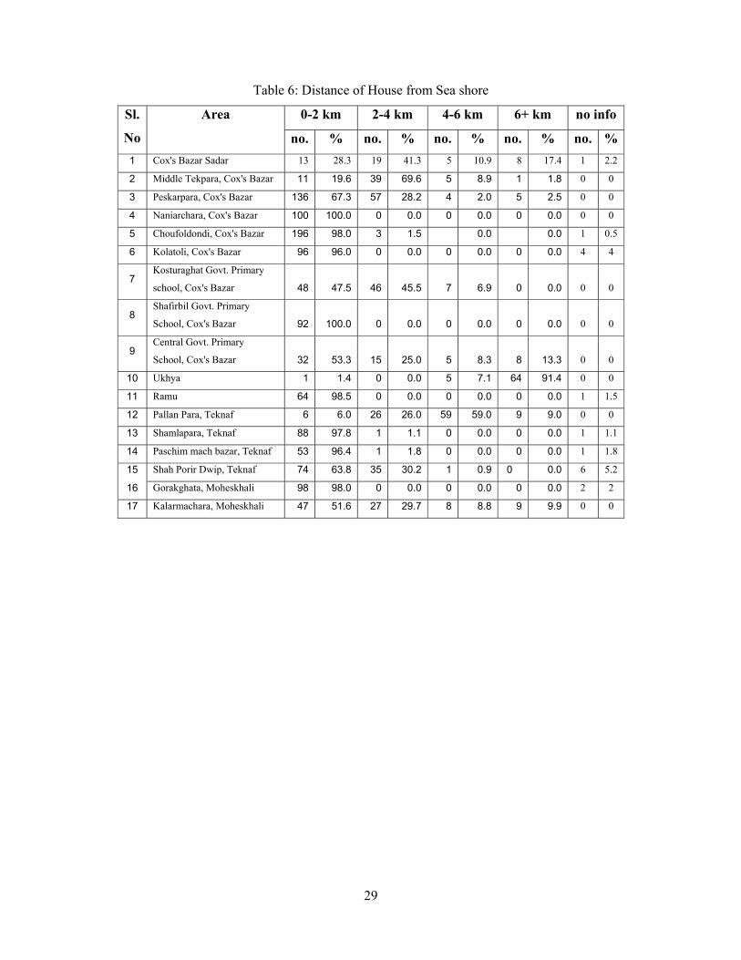
7.2.3 Location of the Inhabitants and Shelters People of Cox’s Bazar live near to shore. Table 6 shows the distances to the households from
the shoreline. It indicates that overall more than 50% of the people surveyed live within 2 km
of the shoreline except Cox's Bazar Sadar, Middle Tekpara, Ukhya and Pallanpara. The
Shelters are also built very close to the sea. Table 7 shows the distance of the cyclone shelters
from the community.
29
Table 6: Distance of House from Sea shore
0-2 km 2-4 km 4-6 km 6+ km no info Sl.
No
Area
no. % no. % no. % no. % no. %1 Cox's Bazar Sadar 13 28.3 19 41.3 5 10.9 8 17.4 1 2.2
2 Middle Tekpara, Cox's Bazar 11 19.6 39 69.6 5 8.9 1 1.8 0 0
3 Peskarpara, Cox's Bazar 136 67.3 57 28.2 4 2.0 5 2.5 0 0
4 Naniarchara, Cox's Bazar 100 100.0 0 0.0 0 0.0 0 0.0 0 0
5 Choufoldondi, Cox's Bazar 196 98.0 3 1.5 0.0 0.0 1 0.5
6 Kolatoli, Cox's Bazar 96 96.0 0 0.0 0 0.0 0 0.0 4 4
7 Kosturaghat Govt. Primary
school, Cox's Bazar 48 47.5 46 45.5 7 6.9 0 0.0 0 0
8 Shafirbil Govt. Primary
School, Cox's Bazar 92 100.0 0 0.0 0 0.0 0 0.0 0 0
9 Central Govt. Primary
School, Cox's Bazar 32 53.3 15 25.0 5 8.3 8 13.3 0 0
10 Ukhya 1 1.4 0 0.0 5 7.1 64 91.4 0 0
11 Ramu 64 98.5 0 0.0 0 0.0 0 0.0 1 1.5
12 Pallan Para, Teknaf 6 6.0 26 26.0 59 59.0 9 9.0 0 0
13 Shamlapara, Teknaf 88 97.8 1 1.1 0 0.0 0 0.0 1 1.1
14 Paschim mach bazar, Teknaf 53 96.4 1 1.8 0 0.0 0 0.0 1 1.8
15 Shah Porir Dwip, Teknaf 74 63.8 35 30.2 1 0.9 0 0.0 6 5.2
16 Gorakghata, Moheskhali 98 98.0 0 0.0 0 0.0 0 0.0 2 2
17 Kalarmachara, Moheskhali 47 51.6 27 29.7 8 8.8 9 9.9 0 0

30
Table 7: Distance of the nearest Cyclone Shelter
0-2 km 2-4 km 4-6 km 6+ km no info Sl.
No
Area
no. % no. % no. % no. % no. %
1 Cox's Bazar Sadar 36 78.3 5 10.9 0 0.0 0 0.0 5 10.9
2 Middle Tekpara, Cox's Bazar 55 96.5 0 0.0 0 0.0 0 0.0 2 3.5
3 Peskarpara, Cox's Bazar 185 92.0 5 2.5 0 0.0 0 0.0 11 5.5
4 Naniarchara, Cox's Bazar 0 0.0 15 15.0 81 81.0 4 4.0 0 0.0
5 Choufoldondi, Cox's Bazar 200 100.0 0.0 0 0.0 0 0.0 0 0.0
6 Kolatoli, Cox's Bazar 85 85.0 15 15.0 0 0.0 0 0.0 0 0
7 Kosturaghat Govt. Primary
school, Cox's Bazar 99 98. 2 2.0 0 0.0 0 0.0 0 0
8 Shafirbil Govt. Primary
School, Cox's Bazar 91 98.9 0 0.0 0 0.0 0 0.0 1 1.1
9 Central Govt. Primary
School, Cox's Bazar 44 73.3 7 11.7 4 6.7 0 0.0 5 8.3
10 Ukhya 67 95.7 0 0.0 0 0.0 0 0.0 3 4.3
11 Ramu 45 69.2 20 30.8 0 0.0 0 0.0 0 0
12 Pallan Para, Teknaf 71 71.0 26 26.0 3 3.0 0 0.0 0 0
13 Shamlapara, Teknaf 90 100.0 0 0.0 0 0.0 0 0.0 0 0
14 Paschim mach bazar, Teknaf 55 100.0 0 0.0 0 0.0 0 0.0 0 0
15 Shah Porir Dwip, Teknaf 90 77.6 6 5.2 0 0.0 0 0.0 20 17.2
16 Gorakghata, Moheskhali 100 100.0 0 0.0 0 0.0 0 0.0 0 0
17 Kalarmachara, Moheskhali 89 97.8 0 0.0 0 0.0 0 0.0 2 2.2
Almost all about 85.3% (as shown in Figure 9) of people responded at as the cyclone shelters
within 2 km from their house. At the time of disaster the way to the shelter becomes very
unsafe for the people. Average distance from one shelter to another is 2 to 3 km.
Figure 9: Distance of nearest cyclone shelter
85.3%
6.1%5.4%
0.2%3.0%
0-2 km
2-4 km
4-6 km
6+ km
no info
31
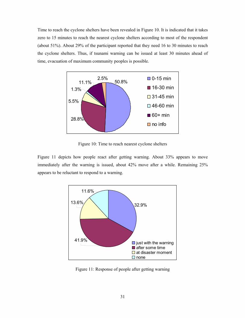
Time to reach the cyclone shelters have been revealed in Figure 10. It is indicated that it takes
zero to 15 minutes to reach the nearest cyclone shelters according to most of the respondent
(about 51%). About 29% of the participant reported that they need 16 to 30 minutes to reach
the cyclone shelters. Thus, if tsunami warning can be issued at least 30 minutes ahead of
time, evacuation of maximum community peoples is possible.
Figure 10: Time to reach nearest cyclone shelters
Figure 11 depicts how people react after getting warning. About 33% appears to move
immediately after the warning is issued, about 42% move after a while. Remaining 25%
appears to be reluctant to respond to a warning.
Figure 11: Response of people after getting warning
2.5%50.8%
28.8%
5.5%
1.3%11.1%
0-15 min
16-30 min
31-45 min
46-60 min
60+ min
no info
11.6%
13.6%
41.9%
32.9%
just with the warningafter some timeat disaster momentnone
32
7.2.4 Emergency Facilities
Government owned shelters have no provision of emergency food, volunteer and first aid
facilities. The NGOs such as World Vision, Gono Shastho Kendro and Red Crescent has
volunteer and first aid facilities. Local people also bring food to the shelter as much as they
can. Nevertheless, government owned cyclone shelters have no practice of preparing
volunteer for emergency period and there is no ongoing programme of that kind of volunteer
preparing activities. Only Red Crescent Society has this kind of activities in each Union level.
In response to the question about the problems of Cyclone Shelter, almost all the surveyed
people stated their sufferings due to lack of sufficient food, water, proper sanitation systems,
emergency medicines and huge congestion along with absence of necessary volunteer
service.
7.2.5 Live Stock Facilities
Most of the cyclone shelters have no livestock facilities. Geographically Cox’s Bazar is a
hilly area, that’s why there is no practice of Killa (high land, above 15 to 20 feet high from
the ground level surrounded by big trees to protect livestock from cyclone and storm surge).
During cyclone people cut off the rope of their cattle and make them free to rescue their lives.
High lands and hills also act as support to protect the livestock.
7.2.6 Early Warning Signals
Most of the cyclone shelters particularly government owned ones have no provision of early
warning and signaling system. In Cox’s Bazar, Red Crescent offers all the responsibility of
early warning and signaling system through hoisting flags. World Vision has the early
warning facilities for their own beneficiary. World Vision in Cox’s Bazar distributed 150
radios to their beneficiaries to disperse immediate information on the possible occurrence of
cyclone.
7.2.7 Warning Dissemination System
Communication and accurate forecasting will be without benefit unless the information can
be conveyed to the people at risk in a timely manner. Warnings are usually disseminated
about 24 hours before the cyclone according to most responded surveyed. The warning in
33
Cox’s Bazar area is broadcasted in formal Bangla language, which is not always
understandable by the coastal people who use local dialect, and most of them are not
educated. The warning system can not distinguish between the possibility of a cyclone
striking Bangladesh and the probability (beyond a reasonable doubt) of and fall, plus the
intensity, likely target, timing and also when to start evacuation. Another challenge of the
warning system is the awareness of the people about the disaster based on which people
respond to a warning. The survey showed that 42.9% people will respond immediately after
receiving of warning while 38.5% move after the disaster take place. However, an immediate
response would be required for earthquake and tsunami disasters.
During the survey a comparative study was made among the cyclones of 1970, 1991 and
1997 to know about the medium and effectiveness of warning dissemination systems. Very
few people could remember about any warning dissemination in 1970. Again, in case of
1991, people stated mainly radio and television where they heard the warning; some people
also mentioned the use of loud speakers and few people could not remember anything about
getting any warning. On the other hand, almost all the people could mention at least one
medium of warning dissemination, in most of the cases even more than one media, regarding
the cyclone of 1997. Along with radio, television, loud speaker, people also mentioned about
the activities of the volunteers and Red Crescent Society and few other NGOs. Another
important matter is that most of the people informed that there is hardly anybody to help them
to reach the cyclone shelter at crisis moments; few volunteers sometimes come forward but
they are not sufficient at all.
7.2.8 People’s participation in ‘Shelter Management’
The government owned shelters are mainly used as educational institutions, particularly
primary schools. School committee has some role in the management of shelters. The NGOs
use their shelters as multipurpose buildings. They also actively manage the shelters. But the
finding of the survey is that the general people are totally unaware of the management of
Shelters. Nobody involve them or they do not participate in the maintenance of the shelters.
Most of the people said that they know nothing about the Shelter Management bodies;
nobody cares about their opinion in this regard even there is no one to tell them about their
responsibilities to maintain and take care of the shelters.
34
7.2.9 Usefulness of Cyclone Shelters and Effectiveness of Warning Dissemination People showed positive attitude towards the effectiveness of Shelters and Warning Systems.
Almost all the people replied that sheltering and warning could ensure more safety and
awareness than previous times and thus contributed significantly in loss reduction. In addition
some people opined that after 1991, no major cyclone has occurred in coastal region; existing
systems might helping in low intensity disaster, but in case of any devastating occurrence it
may not perform at all. That’s why new options and more effectiveness are certainly expected
to be well prepared to fight against inevitable natural disasters. 7.2.10 Applicability to Earthquake and Tsunami Disasters The survey showed that existing sheltering and warning dissemination system is not
sufficient to fight against cyclone in term of warning dissemination system. Moreover they
are not planned on the basis of community requirements. On the other hand, earthquake
occurs without any warning. Thus sheltering system is very important for post disaster rescue
works. If the shelters are not designed considering seismic activities, the shelters themselves
can be vulnerable to earthquake disaster. Tsunami creates high tidal surges and thus causes devastating inundation. Warning system
can play very important role against tsunami disaster since it takes time for water wave to
reach the shore from the source of earthquake. The existing dissemination media can be used
for tsunami but they need to be more effective and quick as the time span of disaster
occurrence is very short. 7.3 Rural Rapid Appraisal Rural Rapid Appraisal (RRA) is suitable for group level evaluation interview. It has been
performed on focus-groups to collect more detailed information on the issues that are of
greatest importance. This technique required the researchers to talk extensively and
informally with rural people and to observe local conditions, while also making use of
secondary information such as administrative records or information from institutions. RRA is a process of learning about rural conditions in an intensive, iterative, and expeditious
manner or any systematic activity designed to draw inferences, conclusions, hypotheses, or
assessments, including the acquisition of new information, during a limited period of time. It
characteristically relies on small multidisciplinary teams that employ a range of
35
methodological tools and techniques specifically selected to enhance understanding of rural
conditions in their natural context, with particular emphasis on tapping the knowledge of
local inhabitants and combining the knowledge with modern scientific expertise but
minimizing prior assumptions. 7.3.1 Development of Questionnaire Objective of this research is to evaluate the effectiveness of the warning system from the
view point of local community and hence to examine the potentiality of using those for
earthquake and tsunami disasters. Two sets of questionnaire were developed for that purpose
according to KII and RRA. By these questionnaires, the existing warning and sheltering
system is evaluated based on the response to the local vulnerable groups. For earthquake and
tsunami disasters, major concern is the time for receiving the warning and the time to reach
the shelter after receiving of the warning, since the time lag between tsunami appearance and
recognition of tsunamigenic earthquake is expected to be less. Thus, the issues of warning
mechanism, time for warning and evacuation, medium used and effectiveness etc. were
focused during development of questionnaires. The questionnaires were developed in such a manner so that they become useful tools to
judge the involvement of the community in the earthquake and tsunami preparedness
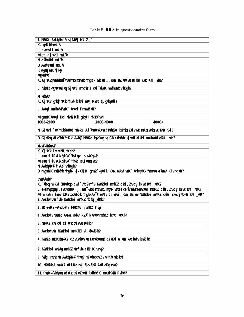
program of the study area. Sample RRA in questionnaire form is shown in Table 8. The
Questions of the survey was developed on the basis of the following considerations, For warning system
• Coverage
• Acceptability
• Warning authority
• Media
• Easily understandable
For shelters
• Connectivity
• Security condition of the shelters
• Sustainability
• Capacity
• Comfortability
36
Table 8: RRA in questionnaire form
1. N~wY©So Avkªq‡K› ª msjMœ GjvKvi Z_¨ K. †gvU RbmsL¨v L. cwiev‡ii msL¨v M. eq¯‹ †jv‡Ki msL¨v N. cÖwZeÜxi msL¨v O. Avw`evwmi msL¨v P. ag©xq msL¨vjNy mvgvwRK K. GjvKvq wewfbœ †¯^”Qv‡mex msMVb †hgb - Gb wR I, K¬ve, BZ¨vw` wK ai‡bi KvR K‡i _v‡K?
L. N~wb©So-‡gvKvwejvq GjvKvi m¤cÖwZ I cvi¯úwiK mn‡hvwMZv †Kgb?
A_©‰bwZK K. GjvKvi gvbyl †Kvb †Kvb †ckvi mv‡_ RwoZ (µgvbymv‡i)
L. Av‡qi mn‡hvMx/weKí Av‡qi Drm wK wK?
M. gvwmK Av‡qi Dci wfwË K‡i gvby‡li †kªYxfvM 1000-2000 2000-4000 4000+
N. GjvKvi `wi`ª Rb‡Mvôxi m‡qi Af¨vm Av‡Q wK? N~wb©So †gŠmy‡g Zviv GB mÂq w`‡q wK KvR K‡i?
O. GjvKvq wK e¨vsK/evRvi Av‡Q? N~wY©So †gvKvwejvq GB cÖwZôvb¸‡jv wK ai‡bi mn‡hvwMZv K‡i _v‡K?
AeKvVv‡gvMZ K. GjvKvi iv¯—v-NvU †Kgb? L. evwo †_‡K Avkªq‡K‡› ª hvIqvi iv¯—v KqwU? M. evwo †_‡K Avkªq‡K‡› ª †h‡Z RUjv nq wK? N. Avkªq‡K‡› ªi Ae ’v †Kgb? O. mvgvwRK cÖwZôvb †hgb-¯‹zj-K‡jR, gmwR`-gw›`i, K¬ve, evRvi weKí Avkªq‡K› ª wnmv‡e e¨envi Kiv nq wK?
cÖvwZôvwbK K. ’vbxq miKvi (BDwbqb cwil`/†cŠimfv) N~wY©S‡oi ms‡KZ cÖPvi, Zv cvj‡b wK K‡i _v‡K? L. e¨emvqx gnj, ivR‰bwZK `j, mvs¯‹…wZK msMVb, mgvR wn‰Zlx e¨w³eM©, N~wY©S‡oi ms‡KZ cÖPvi, Zv cvj‡b wK K‡i _v‡K? M. miKv‡ii †mev`vbKvix cÖwZôvb †hgb-Av¯’v, wk¶v, cïm¤ú`, K…wl, BZ¨vw` N~wY©S‡oi ms‡KZ cÖPvi, Zv cvj‡b wK K‡i _v‡K? 2. Avcbviv wKfv‡e N~wY©S‡oi ms‡KZ †c‡q _v‡Kb?
3. †K ev Kviv Avcbv‡`i N~wY©S‡oi ms‡KZ †`q?
4. Avcbviv N~wY©So AvNvZ nvbvi KZ¶b Av‡M ms‡KZ †c‡q _v‡Kb?
5. ms‡KZ cvIqvi ci Avcbviv wK K‡ib?
6. Avcbviv wK N~wY©S‡oi ms‡K‡Zi A_© †ev‡Sb?
7. N~wY©So mZK© ms‡KZ cZvKv †Kv_vq Dov‡bv nq? cZvKvi A_© wK Avcbviv †ev‡Sb? 8. N~wY©S‡oi AvMvg ms‡KZ wKfv‡e cÖPvi Kiv nq?
9. MÖv‡gi mevB wK Avkªq‡K‡› ª hvq? hviv hvbbv Zviv †Kb hvb bv?
10. N~wY©S‡oi ms‡KZ wK iKg n‡j ¶q-¶wZ Av‡iv Kg n‡e?
11. f~wgK¤ú/mybvwg wK Avcbviv Zv wK Rv‡bb? G m¤ú‡K© wK Rv‡bb?
37
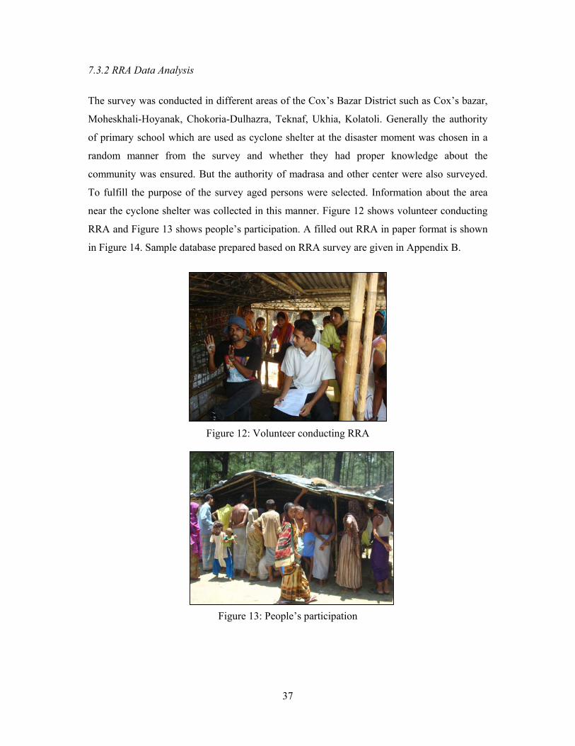
7.3.2 RRA Data Analysis
The survey was conducted in different areas of the Cox’s Bazar District such as Cox’s bazar,
Moheskhali-Hoyanak, Chokoria-Dulhazra, Teknaf, Ukhia, Kolatoli. Generally the authority
of primary school which are used as cyclone shelter at the disaster moment was chosen in a
random manner from the survey and whether they had proper knowledge about the
community was ensured. But the authority of madrasa and other center were also surveyed.
To fulfill the purpose of the survey aged persons were selected. Information about the area
near the cyclone shelter was collected in this manner. Figure 12 shows volunteer conducting
RRA and Figure 13 shows people’s participation. A filled out RRA in paper format is shown
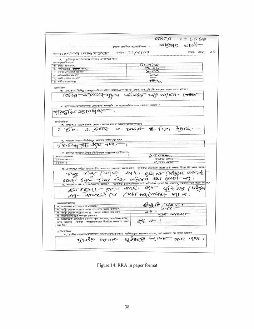
in Figure 14. Sample database prepared based on RRA survey are given in Appendix B.
Figure 12: Volunteer conducting RRA
Figure 13: People’s participation
38
Figure 14: RRA in paper format
39
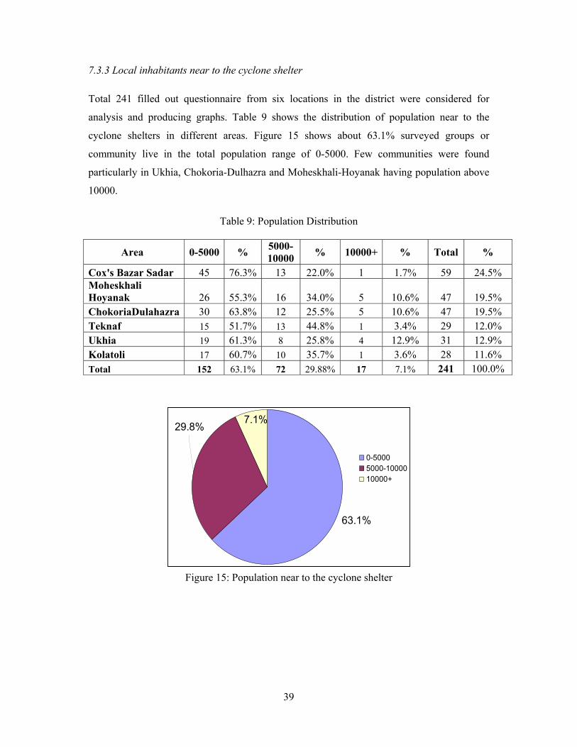
7.3.3 Local inhabitants near to the cyclone shelter Total 241 filled out questionnaire from six locations in the district were considered for
analysis and producing graphs. Table 9 shows the distribution of population near to the
cyclone shelters in different areas. Figure 15 shows about 63.1% surveyed groups or
community live in the total population range of 0-5000. Few communities were found
particularly in Ukhia, Chokoria-Dulhazra and Moheskhali-Hoyanak having population above
10000.
Table 9: Population Distribution
Area 0-5000 % 5000-10000 % 10000+ % Total %
Cox's Bazar Sadar 45 76.3% 13 22.0% 1 1.7% 59 24.5% Moheskhali Hoyanak 26 55.3% 16 34.0% 5 10.6% 47 19.5% ChokoriaDulahazra 30 63.8% 12 25.5% 5 10.6% 47 19.5% Teknaf 15 51.7% 13 44.8% 1 3.4% 29 12.0% Ukhia 19 61.3% 8 25.8% 4 12.9% 31 12.9% Kolatoli 17 60.7% 10 35.7% 1 3.6% 28 11.6% Total 152 63.1% 72 29.88% 17 7.1% 241 100.0%
Figure 15: Population near to the cyclone shelter
7.1%29.8%
63.1%
0-50005000-1000010000+
40
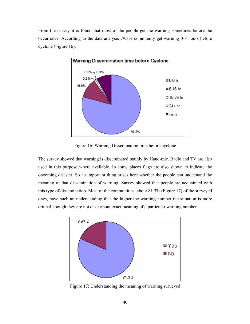
From the survey it is found that most of the people get the warning sometimes before the
occurrence. According to the data analysis 79.3% community get warning 0-8 hours before
cyclone (Figure 16).
Figure 16: Warning Dissemination time before cyclone
The survey showed that warning is disseminated mainly by Hand-mic. Radio and TV are also
used in this purpose where available. In some places flags are also shown to indicate the
oncoming disaster. So an important thing arises here whether the people can understand the
meaning of that dissemination of warning. Survey showed that people are acquainted with
this type of dissemination. Most of the communities, about 81.3% (Figure 17) of the surveyed
ones, have such an understanding that the higher the warning number the situation is more
critical, though they are not clear about exact meaning of a particular warning number.
Figure 17: Understanding the meaning of warning surveyed
41
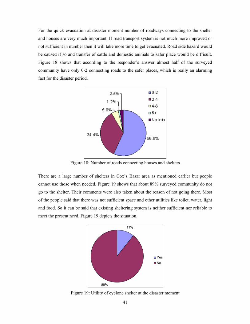
For the quick evacuation at disaster moment number of roadways connecting to the shelter
and houses are very much important. If road transport system is not much more improved or
not sufficient in number then it will take more time to get evacuated. Road side hazard would
be caused if so and transfer of cattle and domestic animals to safer place would be difficult.
Figure 18 shows that according to the responder’s answer almost half of the surveyed
community have only 0-2 connecting roads to the safer places, which is really an alarming
fact for the disaster period.
Figure 18: Number of roads connecting houses and shelters
There are a large number of shelters in Cox’s Bazar area as mentioned earlier but people
cannot use those when needed. Figure 19 shows that about 89% surveyed community do not
go to the shelter. Their comments were also taken about the reason of not going there. Most
of the people said that there was not sufficient space and other utilities like toilet, water, light
and food. So it can be said that existing sheltering system is neither sufficient nor reliable to
meet the present need. Figure 19 depicts the situation.
Figure 19: Utility of cyclone shelter at the disaster moment
11%
89%
YesNo
42
7.3.4. Initiatives of Local Administration and Other Organization
In the coastal area local administration such as Pourosova, Union parishad take some
necessary steps to warn the people. Usually they warn by Mic or using megaphone. Survey
shows that they cannot cover all the area properly. About 19% (Table 10) of the surveyed
groups are out of the coverage of the warning dissemination of the Local Administration.
Table 10: Role of Local Administration
Yes % No % Total % Cox's Bazar Area 51 86.4% 8 13.6% 59 24.5%Moheskhali Hoyanak 42 89.4% 5 10.6% 47 19.5%ChokoriaDulahazra 36 76.6% 11 23.4% 47 19.5%Teknaf 18 62.1% 11 37.9% 29 12.0%Ukhia 25 80.6% 6 19.4% 31 12.9%Kolatoli 24 85.7% 4 14.3% 28 11.6%Total 196 81.3% 45 18.67% 241 100.0%
The contribution of other organizations such as cultural or political parties in warning
dissemination is very poor. Table 11 below shows that 72.61% of the surveyed communities
do not get any help from those organizations.
Table 11: Role of other Organization
Yes % No % Total % Cox's Bazar Area 17 28.8% 42 71.2% 59 24.5%Moheskhali Hoyanak 4 8.5% 43 91.5% 47 19.5%ChokoriaDulahazra 15 31.9% 32 68.1% 47 19.5%Teknaf 6 20.7% 23 79.3% 29 12.0%Ukhia 3 9.7% 28 90.3% 31 12.9%Kolatoli 21 75.0% 7 25.0% 28 11.6%Total 66 27.4% 175 72.61% 241 100.0%
43
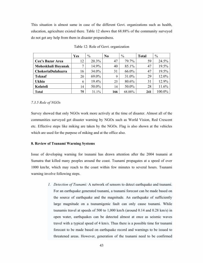
This situation is almost same in case of the different Govt. organizations such as health,
education, agriculture existed there. Table 12 shows that 68.88% of the community surveyed
do not get any help from them in disaster preparedness.
7.3.5 Role of NGOs
Survey showed that only NGOs work more actively at the time of disaster. Almost all of the
communities surveyed get disaster warning by NGOs such as World Vision, Red Crescent
etc. Effective steps like miking are taken by the NGOs. Flag is also shown at the vehicles
which are used for the purpose of miking and at the office also.
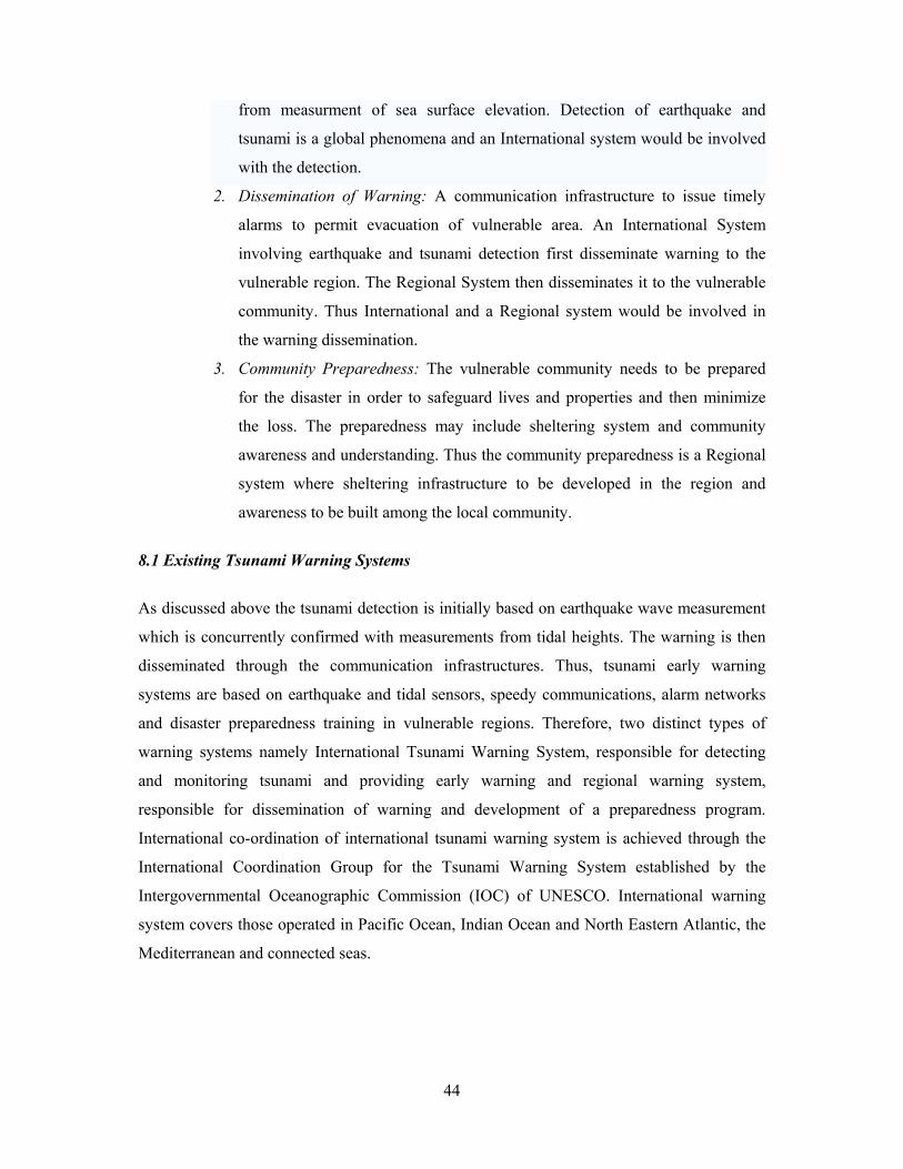
8. Review of Tsunami Warning Systems
Issue of developing warning for tsunami has drawn attention after the 2004 tsunami at
Sumatra that killed many peoples around the coast. Tsunami propagates at a speed of over
1000 km/hr, which may reach to the coast within few minutes to several hours. Tsunami
warning involve following steps.
1. Detection of Tsunami: A network of sensors to detect earthquake and tsunami.
For an earthquake generated tsunami, a tsunami forecast can be made based on
the source of earthquake and the magnitude. An earthquake of sufficiently
large magnitude on a tsunamigenic fault can only cause tsunami. While
tsunamis travel at speeds of 500 to 1,000 km/h (around 0.14 and 0.28 km/s) in
open water, earthquakes can be detected almost at once as seismic waves
travel with a typical speed of 4 km/s. Thus there is a possible time for tsunami
forecast to be made based on earthquake record and warnings to be issued to
threatened areas. However, generation of the tsunami need to be confirmed
Table 12: Role of Govt. organization
Yes % No % Total % Cox's Bazar Area 12 20.3% 47 79.7% 59 24.5%Moheskhali Hoyanak 7 14.9% 40 85.1% 47 19.5%ChokoriaDulahazra 16 34.0% 31 66.0% 47 19.5%Teknaf 20 69.0% 9 31.0% 29 12.0%Ukhia 6 19.4% 25 80.6% 31 12.9%Kolatoli 14 50.0% 14 50.0% 28 11.6%Total 75 31.1% 166 68.88% 241 100.0%
44
from measurment of sea surface elevation. Detection of earthquake and
tsunami is a global phenomena and an International system would be involved
with the detection.
2. Dissemination of Warning: A communication infrastructure to issue timely
alarms to permit evacuation of vulnerable area. An International System
involving earthquake and tsunami detection first disseminate warning to the
vulnerable region. The Regional System then disseminates it to the vulnerable
community. Thus International and a Regional system would be involved in
the warning dissemination.
3. Community Preparedness: The vulnerable community needs to be prepared
for the disaster in order to safeguard lives and properties and then minimize
the loss. The preparedness may include sheltering system and community
awareness and understanding. Thus the community preparedness is a Regional
system where sheltering infrastructure to be developed in the region and
awareness to be built among the local community.
8.1 Existing Tsunami Warning Systems
As discussed above the tsunami detection is initially based on earthquake wave measurement
which is concurrently confirmed with measurements from tidal heights. The warning is then
disseminated through the communication infrastructures. Thus, tsunami early warning
systems are based on earthquake and tidal sensors, speedy communications, alarm networks
and disaster preparedness training in vulnerable regions. Therefore, two distinct types of
warning systems namely International Tsunami Warning System, responsible for detecting
and monitoring tsunami and providing early warning and regional warning system,
responsible for dissemination of warning and development of a preparedness program.
International co-ordination of international tsunami warning system is achieved through the
International Coordination Group for the Tsunami Warning System established by the
Intergovernmental Oceanographic Commission (IOC) of UNESCO. International warning
system covers those operated in Pacific Ocean, Indian Ocean and North Eastern Atlantic, the
Mediterranean and connected seas.
45
8.2 Tsunami Warning in Pacific Ocean
Tsunami warnings for most of the Pacific Ocean are issued by the Pacific Tsunami Warning
Centre (PTWC) and West Coast/Alaska Tsunami Warning Center (WC/ATWC), operated by
the United States's National Oceanic and Atmospheric Administration (NOAA). PTWC,
located in Ewa Beach, Hawaii was established in 1949, following the 1946 Aleutian Island
earthquake and a tsunami that resulted in 165 casualties on Hawaii and Alaska. WC/ATWC
located is in Palmer, Alaska and issues warnings particularly for the west coast of North
America, including Alaska, Canada, and the western coterminous. It was founded in 1967
after the great Alaskan earthquake occurred in Prince William Sound on March 27, 1964.
Both centers use seismic data as its starting point, but then take into account oceanographic
data when calculating possible threats of tsunami. Tide gauges and tsunami detection buoys
in the area of the earthquake are checked to establish if a tsunami wave has formed. The only
early warning system to detect oncoming tsunamis existed in the Pacific region. There is also
a Tsunami Warning Service, established in 1952, and run by the Japan Meteorological
Agency (JMA). In case tsunamis are originated by seismic events far from Japan, JMA takes
a coordinated action with the Pacific Tsunami Warning Center (PTWC) in Hawaii and issues
forecasts for the long-propagating tsunamis. 8.2.1 Pacific Tsunami Warning Centre
The Pacific Tsunami Warning Center (PTWC), operated by NOAA in Ewa Beach, Hawaii,
USA, is a tsunami warning system, overseeing international tsunami prediction and issuing
warnings for the Pacific Ocean area. Area-of-responsibility of the Pacific Tsunami Warning
Center consists of Hawaii, other U.S. interests in the Pacific Basin, countries participating in
the Tsunami Warning System in the Pacific, and on an interim basin Indian Ocean and
Caribbean Sea countries. It serves as the International Tsunami Warning Center for 25
member countries in the Pacific Ocean Basin.
Activities of the earthquake and tsunami warning scheme of the center include locating and
sizing the earthquake; earthquake analysis and review; sea level data analysis to verify the
existence of a tsunami and to calibrate models; and disseminating information to the
appropriate emergency management officials. Seismic data is thus the starting point for
generating the warning. NOAA developed the Deep-ocean Assessment and Reporting of
Tsunamis (DART) system to monitor existence or nonexistence of a tsunami (Figure 20). Six
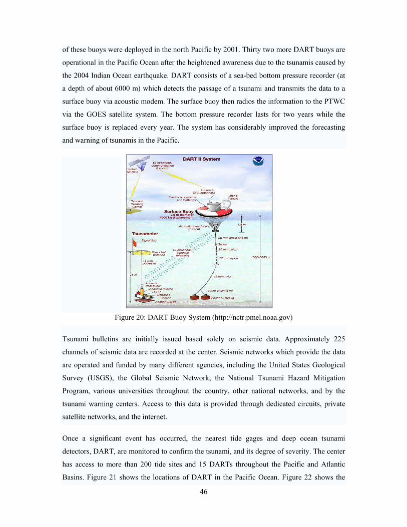
46
of these buoys were deployed in the north Pacific by 2001. Thirty two more DART buoys are
operational in the Pacific Ocean after the heightened awareness due to the tsunamis caused by
the 2004 Indian Ocean earthquake. DART consists of a sea-bed bottom pressure recorder (at
a depth of about 6000 m) which detects the passage of a tsunami and transmits the data to a
surface buoy via acoustic modem. The surface buoy then radios the information to the PTWC
via the GOES satellite system. The bottom pressure recorder lasts for two years while the
surface buoy is replaced every year. The system has considerably improved the forecasting
and warning of tsunamis in the Pacific.
Figure 20: DART Buoy System (http://nctr.pmel.noaa.gov)
Tsunami bulletins are initially issued based solely on seismic data. Approximately 225
channels of seismic data are recorded at the center. Seismic networks which provide the data
are operated and funded by many different agencies, including the United States Geological
Survey (USGS), the Global Seismic Network, the National Tsunami Hazard Mitigation
Program, various universities throughout the country, other national networks, and by the
tsunami warning centers. Access to this data is provided through dedicated circuits, private
satellite networks, and the internet.
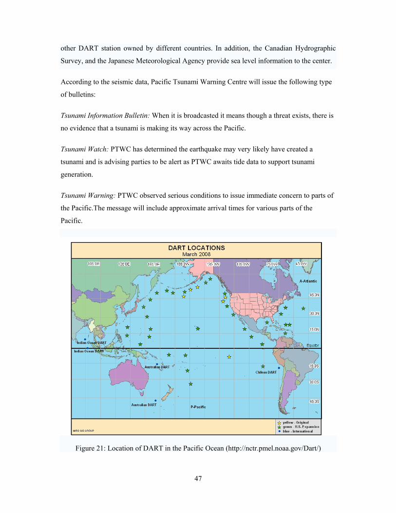
Once a significant event has occurred, the nearest tide gages and deep ocean tsunami
detectors, DART, are monitored to confirm the tsunami, and its degree of severity. The center
has access to more than 200 tide sites and 15 DARTs throughout the Pacific and Atlantic
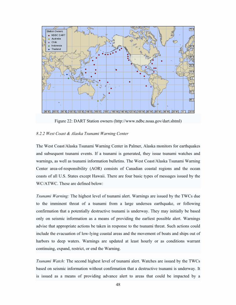
Basins. Figure 21 shows the locations of DART in the Pacific Ocean. Figure 22 shows the
47
other DART station owned by different countries. In addition, the Canadian Hydrographic
Survey, and the Japanese Meteorological Agency provide sea level information to the center.
According to the seismic data, Pacific Tsunami Warning Centre will issue the following type
of bulletins:
Tsunami Information Bulletin: When it is broadcasted it means though a threat exists, there is
no evidence that a tsunami is making its way across the Pacific.
Tsunami Watch: PTWC has determined the earthquake may very likely have created a
tsunami and is advising parties to be alert as PTWC awaits tide data to support tsunami
generation.
Tsunami Warning: PTWC observed serious conditions to issue immediate concern to parts of
the Pacific.The message will include approximate arrival times for various parts of the
Pacific.
Figure 21: Location of DART in the Pacific Ocean (http://nctr.pmel.noaa.gov/Dart/)
48
Figure 22: DART Station owners (http://www.ndbc.noaa.gov/dart.shtml)
8.2.2 West Coast & Alaska Tsunami Warning Center
The West Coast/Alaska Tsunami Warning Center in Palmer, Alaska monitors for earthquakes
and subsequent tsunami events. If a tsunami is generated, they issue tsunami watches and
warnings, as well as tsunami information bulletins. The West Coast/Alaska Tsunami Warning
Center area-of-responsibility (AOR) consists of Canadian coastal regions and the ocean
coasts of all U.S. States except Hawaii. There are four basic types of messages issued by the
WC/ATWC. These are defined below:
Tsunami Warning: The highest level of tsunami alert. Warnings are issued by the TWCs due
to the imminent threat of a tsunami from a large undersea earthquake, or following
confirmation that a potentially destructive tsunami is underway. They may initially be based
only on seismic information as a means of providing the earliest possible alert. Warnings
advise that appropriate actions be taken in response to the tsunami threat. Such actions could
include the evacuation of low-lying coastal areas and the movement of boats and ships out of
harbors to deep waters. Warnings are updated at least hourly or as conditions warrant
continuing, expand, restrict, or end the Warning.
Tsunami Watch: The second highest level of tsunami alert. Watches are issued by the TWCs
based on seismic information without confirmation that a destructive tsunami is underway. It
is issued as a means of providing advance alert to areas that could be impacted by a
49
destructive tsunami. Watches are updated at least hourly to continue them, expand their
coverage, upgrade them to a Warning, or end the alert. A watch for a particular area may be
included in the text of the message that disseminates a Warning for another area.
Tsunami Advisory: The third highest level of tsunami alert. Advisories are issued by the
TWCs to coastal populations within areas not currently in either warning or watch status
when a tsunami warning has been issued for another region of the same ocean. An Advisory
indicates that an area is either outside the current warning and watch regions, or that the
tsunami poses no danger to that area. The Center issuing the Advisory will continue to
monitor the event, issuing updates at least hourly. As conditions warrant, the Advisory will
either be continued, upgraded to a watch or warning, or ended.
Information Statement: A text product issued to inform that an earthquake has occurred and
to advise regarding its potential to generate a tsunami. In most cases, an Information
Statement indicates there is no threat of a destructive tsunami affecting the issuing TWC’s
AOR, and are used to prevent unnecessary evacuations as the earthquake may have been felt
in coastal areas. An Information Statement may, in appropriate situations, caution about the
possibility of a destructive local tsunami. A supplemental Information Statement may be
issued if important additional information is received such as a sea level reading showing a
tsunami signal. An Information Statement may also be upgraded to a watch or warning if
appropriate. Further, the Information Statement may be used to recommend a warning when
protocols agreed to by emergency management authorities within an AOR so specify. 8.2.3 Japan Meteorological Agency
Six regional centres connected up to 300 sensors located across Japan's islands, including
around 80 water-borne sensors, monitor seismic activity round the clock. If an earthquake
looks as if it has the potential to trigger a tsunami, the JMA issues an alert within three
minutes of it being identified. The alerts are broadcast on all radio and TV channels, and if
necessary an evacuation warning is also given. Using data from its seismographs and buoys
in the Indian Ocean, Japan's Meteorological Agency also fax to Sri Lanka and Singapore
information on quakes bigger than magnitude-7 and possible tsunami within 30 minutes of
the initial tremors.The JMA aims to give people in the path of the wave at least 10 minutes'
warning to evacuate the area. Local authorities, central government and disaster relief
organisations also get warnings via special channels so they can respond to a disaster swiftly.
50
JMA's network can predict the height, speed, and destination and arrival time of any tsunami
destined for Japanese shores. JMA's seismological network consists of about 180 seismic
stations. The seismic data are transmitted on a real time basis by the dedicated telephone lines
to the JMA headquarters and centers in each District Observatory. Transmission lines are
connected between neighboring centers to share the earthquake data. This network allows for
continued monitoring and analyzing of earthquakes, even if part of the network would be
damaged by a large earthquake. By using the seismic network and processing computers,
earthquake location and magnitude are determined quickly after detection of the earthquake.
A database of the relationship between earthquake occurrence and tsunami arrival based on
about 100,000 cases of computer simulation is prepared for tsunami forecast around Japan
(the quantitative tsunami forecast system).
When a large earthquake occurs, the database is searched using the location and magnitude of
the earthquake as indices, and the stored heights and arrival times of tsunami along the coasts
are read out, for the issuance of tsunami warning for individual 66 tsunami forecast blocks in
the Japanese coastal area.
In case of an earthquake occurrence, JMA analyzes the earthquake observational data and
quickly issues tsunami warning, if necessary. The warning is automatically transmitted to
disaster management authorities and broadcasting media. The earthquake and tsunami
information including tsunami warning is used as a trigger of evacuation and urgent operation
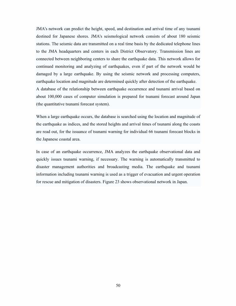
for rescue and mitigation of disasters. Figure 23 shows observational network in Japan.
51
Figure 23: Observation Network and Transmission of Tsunami Warning in Japan
(http://www.jma.go.jp)
52
In case of an earthquake occurrence, JMA analyzes the earthquake observational data and
quickly issues tsunami warning, if necessary. The warning is automatically transmitted to
disaster management authorities and broadcasting media. The earthquake and tsunami
8.3 Indian Ocean Tsunami Warning System (ICG/IOTWS)
The Indian Ocean Tsunami Warning System is a tsunami warning system set up to provide
warning to inhabitants of nations bordering the Indian Ocean of approaching tsunamis. It was
agreed in a United Nations conference held in January 2005 in Kobe, Japan as an initial step
towards an International Early Warning Programme.
The system became active in late June 2006 following the leadership of UNESCO. It consists
of 25 seismographic stations relaying information to 26 national tsunami information centers,
as well as three deep-ocean sensors. However, UNESCO warned that further coordination
between governments and methods of relaying information from the centers to the civilians at
risk are required to make the system effective.
Eighteen months after the tragic tsunami of December 2004, the entire Indian Ocean region
has a warning system capable of receiving and distributing tsunami advisories around the
clock by the end of July 2006. This initial system will be capable of improved and faster
detection of strong, tsunamogenic earthquakes; increased precision in the location of the epi-
and hypocentres of earthquakes; confirmation of the presence of a tsunami wave in the ocean
after a strong earthquake; issuing a ‘tsunami watch’, ‘regional watch’ or a ‘global tsunami
ocean warning’; and calling off ‘tsunami watches’ and ‘regional ‘tsunami watches.”
Twenty-six out of a possible 28 national tsunami information centres, capable of receiving
and distributing tsunami advisories around the clock have been set up in Indian Ocean
countries. The seismographic network has been improved, with 25 new stations being
deployed and linked in real-time to analysis centres. There are also three Deep-ocean
Assessment and Reporting of Tsunamis (DART) sensors. The Commission for the Nuclear-
Test Ban Treaty Organization (CTBTO) is also contributing data from seismographic
stations.
At present, information bulletins are issued from Japan and Hawaii, pending a final decision
on the location of regional centres in the Indian Ocean. This will be facilitated when
important additional contribution including instruments such as deep-sea pressure sensors and
satellites become available in late 2007 and 2008.
53
8.4 Tsunami Warning in North Eastern Atlantic, the Mediterranean and connected Seas
(ICG/NEAMTWS)
Warning systems are also being established in the North East Atlantic, Mediterranean and
Adjoining Seas, and the Caribbean. Protection is also being reinforced in the South West
Pacific and the South China Sea.
Tsunami Warning System (TWS) in Russia was organized in 1958, six years after destructive
tsunami of November 4, 1952. Two departments are responsible for the TWS functioning: 1)
Federal Service for Hydrometeorology and Environment Monitoring and 2) Geophysics
Service of Russia Academy of Science (RAS). Russia Far East TWS consists of three
Regional Services: Sakhalin, Kamchatka and Primorye Services. At the present stage of
development of a science is not obviously possible to predict an earthquake but after one's
occurring to some probability a tsunami generation is predictable.
In Sakhalin Region the TWS consists of Tsunami Warning Center (TWC) and Seismic
Station of RAS Geophysical Service, both located in Yuzno-Sakhalinsk. The TWC's primary
objective is to provide timely tsunami warnings, all clears and information to the people and
organizations and also studying of tsunami phenomenon. The seismic station is responsible
for Tsunami Warning issuance in case of near source quakes when epicentral distance is up to
3000 km from Yuzno-Sakhalinsk while TWC issues warnings based on tsunami information
after occurring of major quakes in the Pacific with distance of more than 3000 km.
Issued Tsunami Warning transmits to Civil Defence and Emergency Regional Headquarters
and to Central Telegraph Station of Yuzno-Sakhalinsk. TWC personnel after an occurred
earthquake computes tsunami arrival times for Sakhalin and Kuril Isls coastal places, then
determines danger ending, issues all clear in all cases.
In accordance with international agreements in case of emergency Sakhalin TWC cooperates
with TWC abroad. Sakhalin TWC prepares for Regional Emergency Commission
information about expected and real conditions after occurred underwater earthquake and
information about intensity and consequences of major quakes occurred on land.
For the period of 1958 - 1998 in Sakhalin and Kuril Isls there were registered 42 tsunami, 34
of them were generated in near-source zone (Kuril-Kamchatka Trench, Japan and Okhotsk
seas) and 8 - in distant regions of the Pacific.
54
Tsunami waves are generated not in all cases of occurring of major earthquakes near coast
but considering that generation probability is high, Tsunami Warning are issued always when
magnitude is greater or equal threshold (for the Kuril-Kamchatka Trenh, Japan and Okhotsk
seas threshold is 7.0).
9. Development of Regional Warning System
It is revealed with reference to the tsunami warning system in Indian Ocean that Information
bulletin on potential hazards are issued to the Indian Ocean countries including Bangladesh
from Japan and Hawaii. However, final decision about the warning and preparation is
pending on the regional countries. Thus development of a regional system for each country
would be required for a disaster preparedness program.
9. 1 Concept of Operations
Anderson (2006) reviewed different aspects of a regional system required to make the
disaster preparedness as effective. Three steps have been identified for an effective disaster
preparedness program of a regional system as follows:
1. Reception and authentication of external hazard event and warning information by
monitors located at the Disaster Risk Management Center and dissemination to
targeted communities specially equipped with Hazard Information technologies.
The activities of Disaster Risk Management Centre are:
• Receiving an Event of Interest (EOI);
• authenticating/Confirming the EOIs with a Center Executive
• constructing a Message for the communities
• Relaying the message to Hazard Information devices in
designated communities
2. Reception and authentication of messages by the Guardians in communities
equipped with hazard information devices and dissemination.
3. Community response according to the message after receiving of the warning
message
55
9.2 Community preparedness
Community preparedness is a very important part of a disaster preparedness programme
where community should understand the message disseminated to them and should be able to
respond according to the message. Following training activities is recommended for a
community for disaster preparedness:
• hazard mapping
• resource mapping
• risk assessment and
• identification of vulnerable households and groups of people in the
community
– Creating awareness of the early warning mechanism in place and the response
activities that need to be undertaken;
– Enabling the identification of appropriate dissemination mechanism to
vulnerable households;
– Enable formulation of a response plan, which includes an evacuation plan with
clear actions, roles and responsibilities and identify resources needed;
– Instill the competency to conduct an evacuation drill which is comprehensive;
– Provide the ability to measure the effectiveness of response plans carried out
as simulations.
9.3 Hazard Information Devices in Srilanka
Five different Information and Communication Technologies (ICTs) were reviewed to
evaluate their suitability in varied settings for “last mile of a national disaster warning
system” for Sri Lanka (Anderson, 2006). The ICTs are shortly discussed below. CDMA Fixed Wireless Phones:
The CDMA fixed wireless phones provide standard dial-tone voice phone services and are
very useful, especially in rural areas that have limited or no wire-line services. They are
relatively fast and dependable, portable and can be easily re-located. Further, usage requires
little or no training. But they are vulnerable to congestion during periods of high intensity of
traffic that may be generated by people’s responses to the disaster.
56
Mobile Telephones-Cell Broadcasting:
Cell broadcasting uses an existing function of cellular networks which allows a text message
to be broadcast to all cellular phones of a particular operator in a given geographical area. It
places a very low load on the network and also impervious to network congestion. It can
support multiple channels for different message types and can be activated remotely by the
network operator.
Addressable Satellite Radio (ASR):
ASR supports a variety of functions including text alerts, both short and extended, audio
broadcasts of unlimited length, geographical, individual and group based message targeting.
Further, because the receivers’ signals are fed from a geostationary satellite, and receivers
can be DC battery operated, ASR can operate independently of local or national
infrastructure. However, programming and loading message content into the system is still
dependent upon having a reliable Internet connection.
VSAT-Internet delivered web/e-mail bulletins:
Internet access delivered to users in remote areas is possible with Very Small Aperture
Terminal (VSAT) technology that uses a satellite connection as a high-speed digital link
between the user and the Internet backbone. VSAT is a relatively robust and reliable
communication link which is available at a reasonable cost.
Amateur Ham Radio:
During the Indian Ocean tsunami that destroyed electricity and communication infrastructure
in the Andamans & the Nicobar islands, amateur ham radio amateurs were the critical link
between the islands and the Indian mainland and helped in the coordination of rescue and
relief operations.
Although CDMA and GSM technologies are available in Bangladesh but they are liable to
challenges, especially due to network jam in emergency situation. Considering the challenges
faced in Srilanka and the suitability for Bangladesh, the system with Addressable Satellite
Radio appeared the most efficient one for deploying in Cox’s Bazar Bangladesh.
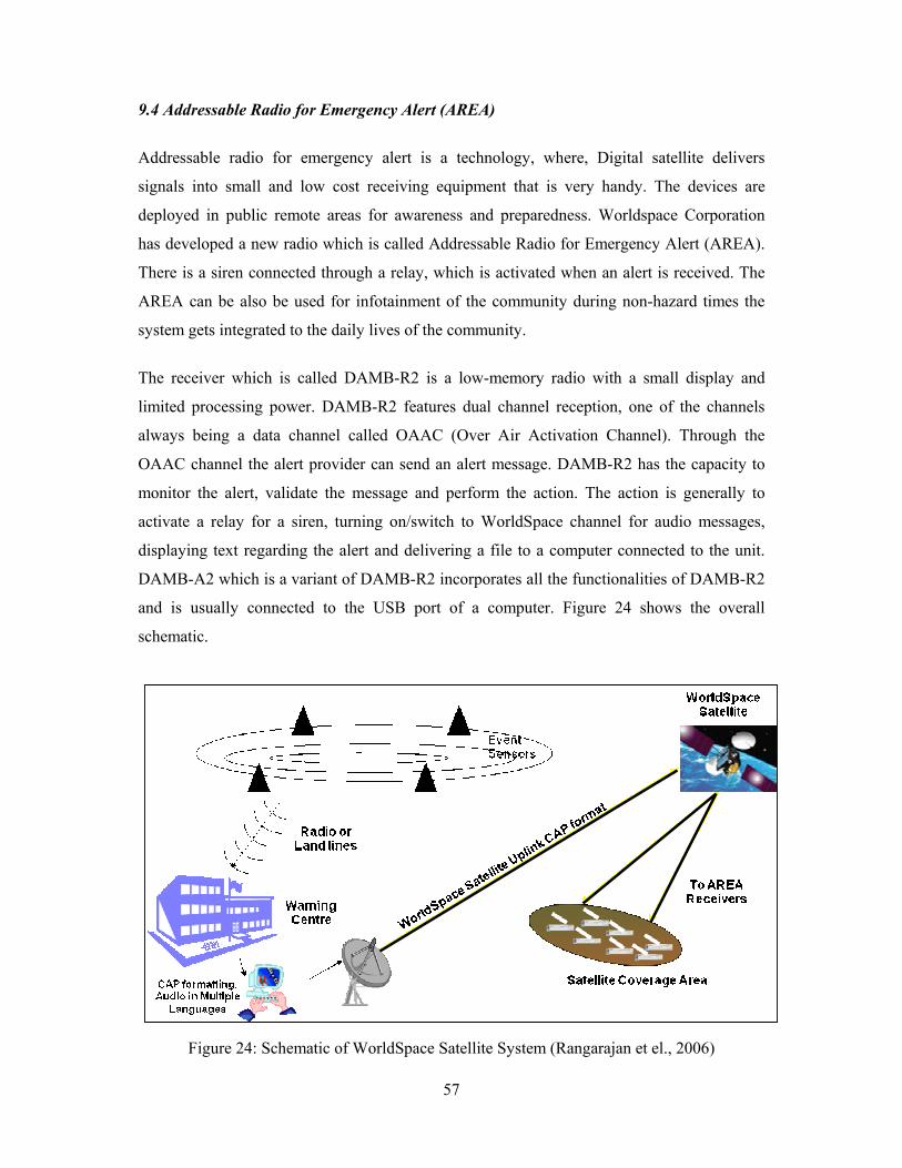
57
9.4 Addressable Radio for Emergency Alert (AREA)
Addressable radio for emergency alert is a technology, where, Digital satellite delivers
signals into small and low cost receiving equipment that is very handy. The devices are
deployed in public remote areas for awareness and preparedness. Worldspace Corporation
has developed a new radio which is called Addressable Radio for Emergency Alert (AREA).
There is a siren connected through a relay, which is activated when an alert is received. The
AREA can be also be used for infotainment of the community during non-hazard times the
system gets integrated to the daily lives of the community.
The receiver which is called DAMB-R2 is a low-memory radio with a small display and
limited processing power. DAMB-R2 features dual channel reception, one of the channels
always being a data channel called OAAC (Over Air Activation Channel). Through the
OAAC channel the alert provider can send an alert message. DAMB-R2 has the capacity to
monitor the alert, validate the message and perform the action. The action is generally to
activate a relay for a siren, turning on/switch to WorldSpace channel for audio messages,
displaying text regarding the alert and delivering a file to a computer connected to the unit.
DAMB-A2 which is a variant of DAMB-R2 incorporates all the functionalities of DAMB-R2
and is usually connected to the USB port of a computer. Figure 24 shows the overall
schematic.
Figure 24: Schematic of WorldSpace Satellite System (Rangarajan et el., 2006)
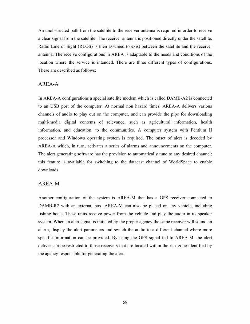
58
An unobstructed path from the satellite to the receiver antenna is required in order to receive
a clear signal from the satellite. The receiver antenna is positioned directly under the satellite.
Radio Line of Sight (RLOS) is then assumed to exist between the satellite and the receiver
antenna. The receive configurations in AREA is adaptable to the needs and conditions of the
location where the service is intended. There are three different types of configurations.
These are described as follows:
AREA-A In AREA-A configurations a special satellite modem which is called DAMB-A2 is connected
to an USB port of the computer. At normal non hazard times, AREA-A delivers various
channels of audio to play out on the computer, and can provide the pipe for downloading
multi-media digital contents of relevance, such as agricultural information, health
information, and education, to the communities. A computer system with Pentium II
processor and Windows operating system is required. The onset of alert is decoded by
AREA-A which, in turn, activates a series of alarms and announcements on the computer.
The alert generating software has the provision to automatically tune to any desired channel;
this feature is available for switching to the datacast channel of WorldSpace to enable
downloads.
AREA-M Another configuration of the system is AREA-M that has a GPS receiver connected to
DAMB-R2 with an external box. AREA-M can also be placed on any vehicle, including
fishing boats. These units receive power from the vehicle and play the audio in its speaker
system. When an alert signal is initiated by the proper agency the same receiver will sound an
alarm, display the alert parameters and switch the audio to a different channel where more
specific information can be provided. By using the GPS signal fed to AREA-M, the alert
deliver can be restricted to those receivers that are located within the risk zone identified by
the agency responsible for generating the alert.
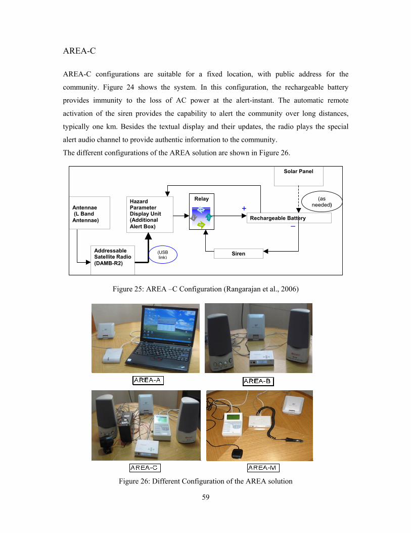
59
AREA-C AREA-C configurations are suitable for a fixed location, with public address for the
community. Figure 24 shows the system. In this configuration, the rechargeable battery
provides immunity to the loss of AC power at the alert-instant. The automatic remote
activation of the siren provides the capability to alert the community over long distances,
typically one km. Besides the textual display and their updates, the radio plays the special
alert audio channel to provide authentic information to the community.
The different configurations of the AREA solution are shown in Figure 26.
Figure 25: AREA –C Configuration (Rangarajan et al., 2006)
Figure 26: Different Configuration of the AREA solution
WorldSpace Antennae (L Band Antennae)
Addressable Satellite Radio (DAMB-R2)
Hazard Parameter Display Unit (Additional Alert Box)
(USB link)
+_
(as needed)
Relay
Solar Panel
Rechargeable Battery
Siren
60
9.5 Operation When an emergency message is to be communicated the authority after due process of
validation start broadcasting messages and feed contents to the AREA C and AREA M
receivers. The radio will automatically switch its channel to a special channel and start
relaying the broadcast message and also display the alert parameters. Once the alert is recognized by the receiver, an audio alarm is generated. In AREA-C
configurations, it closes a relay which activates the siren which can be heard over a radius of
typically 1 km. In contrast, AREA-A provides a computer generated warning signal, while
AREA-M uses a buzz for drawing the attention to the alert. After the cancellation of the
message all AREA receivers will switch back to its original mode. The AREA receiver has a
provision to automatically switch on itself on the special broadcast, even if it is in an off
mode (i.e. music not playing for any reason), and sound the alarm. A User’s Manual for the
receiving and broadcasting of messages has been provided in Appendix C. 9.6 Installation of AREA in Bangladesh For installation of AREA C receivers it was found appropriate and secured place in
Government Administration offices i.e. Upazila administration offices. Eight AREA C
receivers were handed over to the Project Implementation Officer at eight Upazilas of Cox's
Bazar district, one to the District Relief and Rehabilitation officer and another one to the
Chairman of the Saint Martin’s Island. 10. Earthquake Warning Although Seismologists all over the world have agreed that earthquake prediction will not be
available very soon, efforts have been made for developing earthquake warning after
occurrence of earthquake but before reaching the effects to the vulnerable area. In case of an
earthquake energy radiates outward in all direction.
This energy travels through and around the earth as three types of seismic waves defined as
follows:
1. Primary Wave
2. Secondary Wave
3. Surface Wave
Figure 26 shows the waves formed after an earthquake.
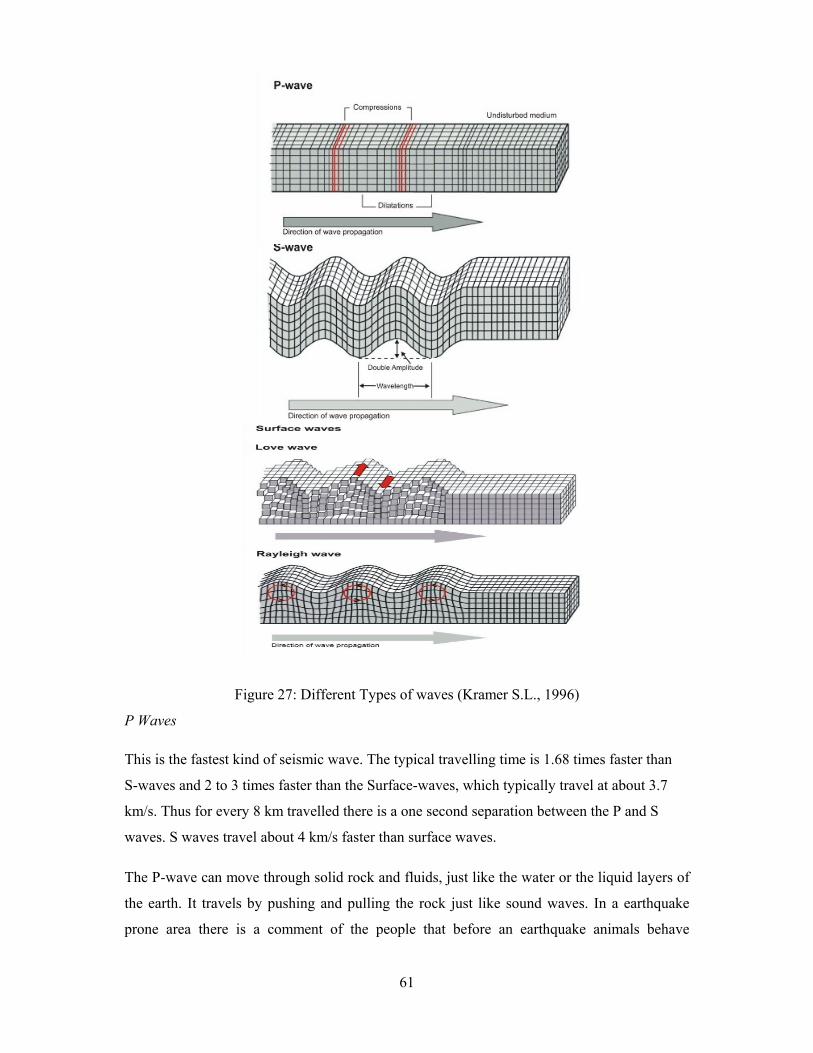
61
Figure 27: Different Types of waves (Kramer S.L., 1996)
P Waves This is the fastest kind of seismic wave. The typical travelling time is 1.68 times faster than
S-waves and 2 to 3 times faster than the Surface-waves, which typically travel at about 3.7
km/s. Thus for every 8 km travelled there is a one second separation between the P and S
waves. S waves travel about 4 km/s faster than surface waves. The P-wave can move through solid rock and fluids, just like the water or the liquid layers of
the earth. It travels by pushing and pulling the rock just like sound waves. In a earthquake
prone area there is a comment of the people that before an earthquake animals behave
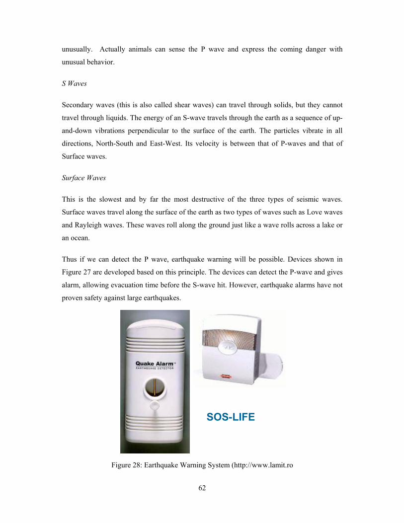
62
unusually. Actually animals can sense the P wave and express the coming danger with
unusual behavior.
S Waves
Secondary waves (this is also called shear waves) can travel through solids, but they cannot
travel through liquids. The energy of an S-wave travels through the earth as a sequence of up-
and-down vibrations perpendicular to the surface of the earth. The particles vibrate in all
directions, North-South and East-West. Its velocity is between that of P-waves and that of
Surface waves.
Surface Waves
This is the slowest and by far the most destructive of the three types of seismic waves.
Surface waves travel along the surface of the earth as two types of waves such as Love waves
and Rayleigh waves. These waves roll along the ground just like a wave rolls across a lake or
an ocean.
Thus if we can detect the P wave, earthquake warning will be possible. Devices shown in
Figure 27 are developed based on this principle. The devices can detect the P-wave and gives
alarm, allowing evacuation time before the S-wave hit. However, earthquake alarms have not
proven safety against large earthquakes.
Figure 28: Earthquake Warning System (http://www.lamit.ro
SOS-LIFE
63
11. Summary
The objective existing Warning Dissemination System and Cyclone Shelters of Cox’s Bazar,
Bangladesh have been evaluated in this project with a goal to develop an effective Regional
Warning Dissemination System for Cox’s Bazar District. The study revealed that even
though the existing cyclone shelters in the country are insufficient to accommodate the huge
population at risk, the shelteres can be used for cyclone and tsunami hazards. Time to reach
to the most of the shelters is 15 to 30 minutes. However attention is required on connectivity,
accessibility and security during disaster period.
The existing early warning dissemination system has been successful in reducing loss of lives
and properties. However, there is a scope for improvement of the system from the view point
of the community. The Flag-based warning is not always understandable to local community.
Education among the communities through training program and revision of warning
messages to include more specific information about the intensity, target area, evacuation
time etc. would be helpful in this regard. A supplementary warning system is expected to
improve the effectiveness and reliability of the system.
Considering the facts, an emergency early warning system, the WorldSpace Satellite System
has been proposed and deployed in the study area on a pilot basis. This system appeared to be
reliable and usable for multi-disaster approach. It is able to disseminate warning in different
forms and the information delivered can be chosen on the basis of the requirement of the
different risk zones. It can disseminate warning to remote areas where other networks of
information transfer often fail.
The findings of the research thus expected to be a milestone on the way to ensure the success
of community preparedness program for disastrous regions of the country and contribute
significantly in reducing losses.

64
LIST OF REFERENCES Anderson, P. (2006). Last of the Mile Hazard Warning System (LM-HWS) ICT Assessment
and Community Simulation Observation report. LirneAsia, Colombo, Srilanka.
Asia tsunami warning system ready, BBC News, 28 June 2006
B.B.S. (2001). Bangladesh Bureau of Statistics, (Udin and Yasmin, 2005)
CPP and BDRCS, (2002). Cyclone Preparedness Program, Bangladesh Red Crescent Society,
2002
http:// www.crisscross.com
http://www.enviortech.org
http://www.jma.go.jp
http://www.noaa.gov
http://nctr.pmel.noaa.gov/Dart/
http://www.ndbc.noaa.gov/dart.shtml
http://www.lamit.ro
Indian Ocean Tsunami Warning System up and running, UNESCOPRESS, 28 June 2006
Kramer, S. L. (1996), Geotechnical Earthquake Engineering, Prentice Hall, Inc., Upper
Saddle River, New Jersey, Chapter-2, Page 19-20
L.G.E.D. (2003). Local Government Engineering Department, (Udin and Yasmin, 2005)
S. Rangarajan, Jerome Soumagne and Jean-Luc Vignaud, 2006. Addressable Radios for
Emergency Alert (AREA): A WorldSpace Solution for Effective Delivery of Alerts
Uddin, A. M. K. and Yasmin, A. (2005), “District Information-Cox’s Bazar”, Water
Resource Ministry, Water Resource Planning Organization, People’s Republic of
Bangladesh Government
UN plans interim tsunami warning system that could be running almost at once, UN News,
31 January 2005
Recommended