1
Spatial and Environmental Surveys Department
Dominika Rogalińska
Delineating Cities and Rural Areas.Polish case study
New York, United Nations Expert Group Meeting on Statistical Methodology for Delineating Cities and Rural Areas, UNHQ28-30.01.2019

2stat.gov.pl
• On January 1, 1999 the new administrative division was introduced in Poland.
The two stage administrative division used since 1975 has been replaced with a three-stage one that consists of voivodeships, counties, and municipalities (communes).
• The new administrative division has been slightly modified since its introduction.
Background – administrative division of Poland
380 counties(Polish: powiat)
16 voivodeships(Polish: województwo)
2477 municipalities(Polish: gmina)
As on 1 January 2019

3stat.gov.pl
The National Official Register of the Territorial Division of the Country (TERYT) which is based on administrative (formal) division of municipalities (Polish: gmina) into:• urban municipalities (including
only cities/towns) – 302 entities (as of 1 January 2018)
• rural municipalities (including only rural areas) – 1548 entities
• urban-rural municipalities (including both cities within their administrative borders and rural areas) – 628 entities
Types of municipalities in Poland
4stat.gov.pl
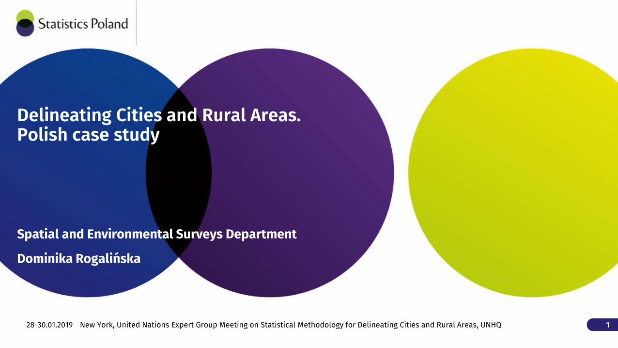
The division based on the National Official Register of the Territorial Division of the Country (TERYT).Urban areas:• areas within administrative
boundaries of cities and towns (i.e. urban municipalities and urban areas of urban-rural municipalities)
Rural areas:• areas outside administrative
boundaries of cities and towns (i.e. rural municipalities and rural parts of urban-rural municipalities)
Urban and rural areas in Poland

5stat.gov.pl
According to the degree of urbanisation (DEGURBA) elaborated by Eurostat there are:• 74 municipalities classified as
„cities”• 527 municipalities classified as
„towns and suburbs”• 1877 municipalities classified as
„rural areas”
Degree of urbanisation (DEGURBA) in Poland

6stat.gov.pl
Comparison: Polish classification v. DEGURBAIn total (as of 2018) there were 1,775 out of 2,477 municipalities in Polish division (71.6%) assigned analogically to the DEGURBA division; 84 municipalities (3.4%) had lower assignment in DEGURBA (by 1 class); assignment of 619 municipalities (25.0%) was overrated in comparison to DEGURBA (597 by 1 class, 22 by 2 classes)

7stat.gov.pl
There is no official definition of "main city" in Poland. For statistical purposes (as well as i.e. in the National Urban Policy) cities are categorized into:• small cities (with less than 20,000
inhabitants – 712 entities), • medium-sized cities (with 20-100
thousand inhabitants – 179 entities) and
• large cities (with over 100,000 inhabitants - 39 cities) is used.
In this manner, large cities might be considered as "main cities".Moreover, capitals of voivodeships (18 cities) also tend to be considered "main cities"
Main cities in Poland

8stat.gov.plAll large cities (and all capitals of voivodeships) are classified in DEGURBA as "cities".
Cities: DEGURBA’s „cities” vs. „large cities”
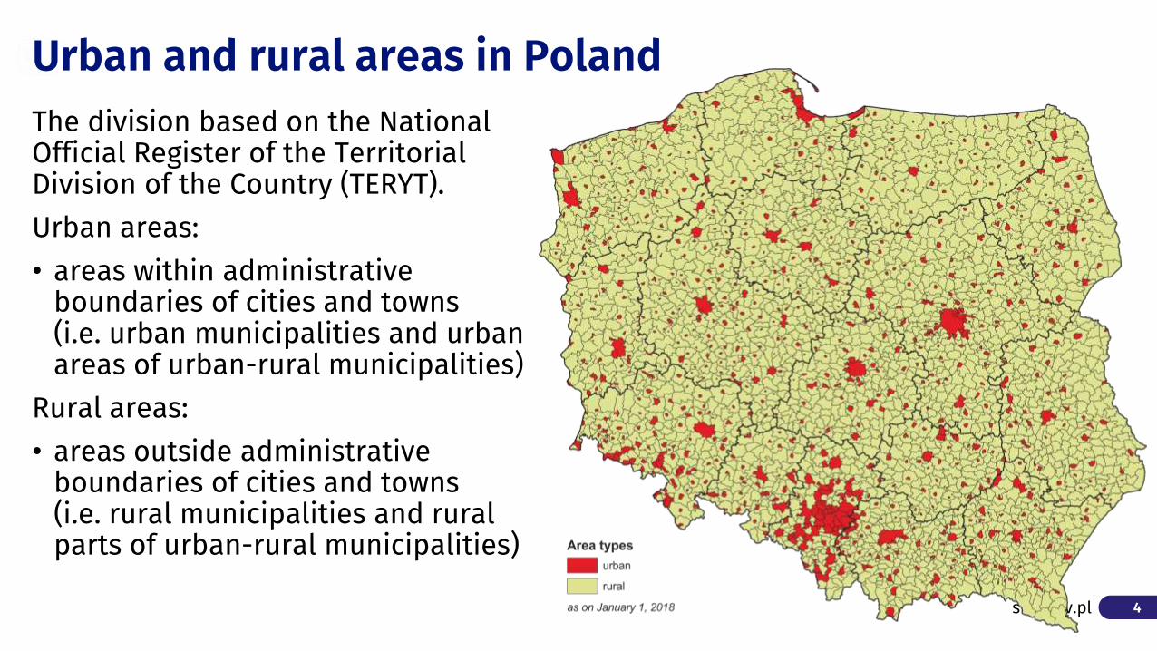
9stat.gov.plTERYT division - 1548 rural municipalitiesDEGURBA – 1877 municipalities are classified as "rural areas";
Rural areas: DEGURBA vs. TERYT

10stat.gov.pl
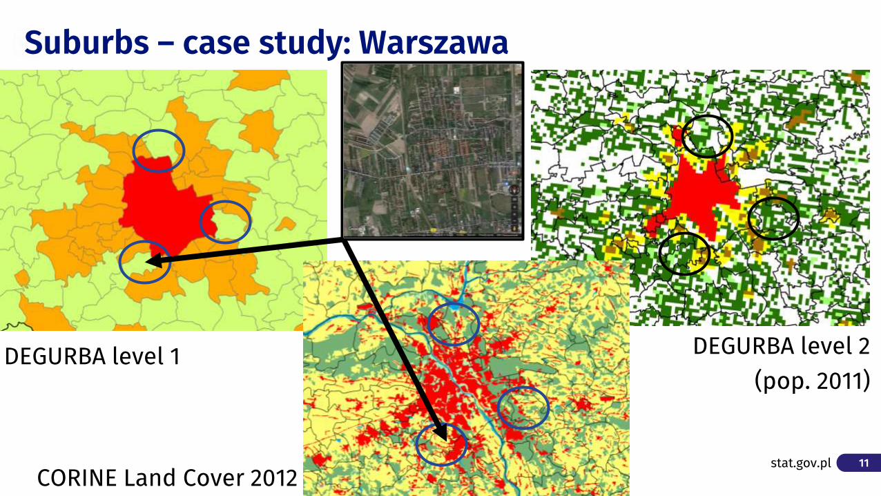
DEGURBA level 2
11stat.gov.pl
DEGURBA level 1
Suburbs – case study: Warszawa
DEGURBA level 2 (pop. 2011)
CORINE Land Cover 2012

12stat.gov.pl
DEGURBA level 1
Suburbs – case study: Wrocław
DEGURBA level 2 (pop. 2011)
CORINE Land Cover 2012

13stat.gov.pl
DEGURBA level 1
Suburbs – case study: Kraków
DEGURBA level 2 (pop. 2011)
CORINE Land Cover 2012

14stat.gov.pl
Population of types of units

15stat.gov.pl
There are 58 Functional Urban Areas in Poland
Functional Urban Areas (FUA)

16stat.gov.pl
There are 24 areas of integrated territorial investments (ITI) in Poland
Areas of integrated territorial investments (ITI)

17stat.gov.pl
Degurba level 2 vs. Degurba level 2 – Łomża example
Degurba model in the GHSL framework (SMOD) Degree of urbanisation level 2 of Europe in the coordinate system ETRS_1989_LAEA.
18stat.gov.pl
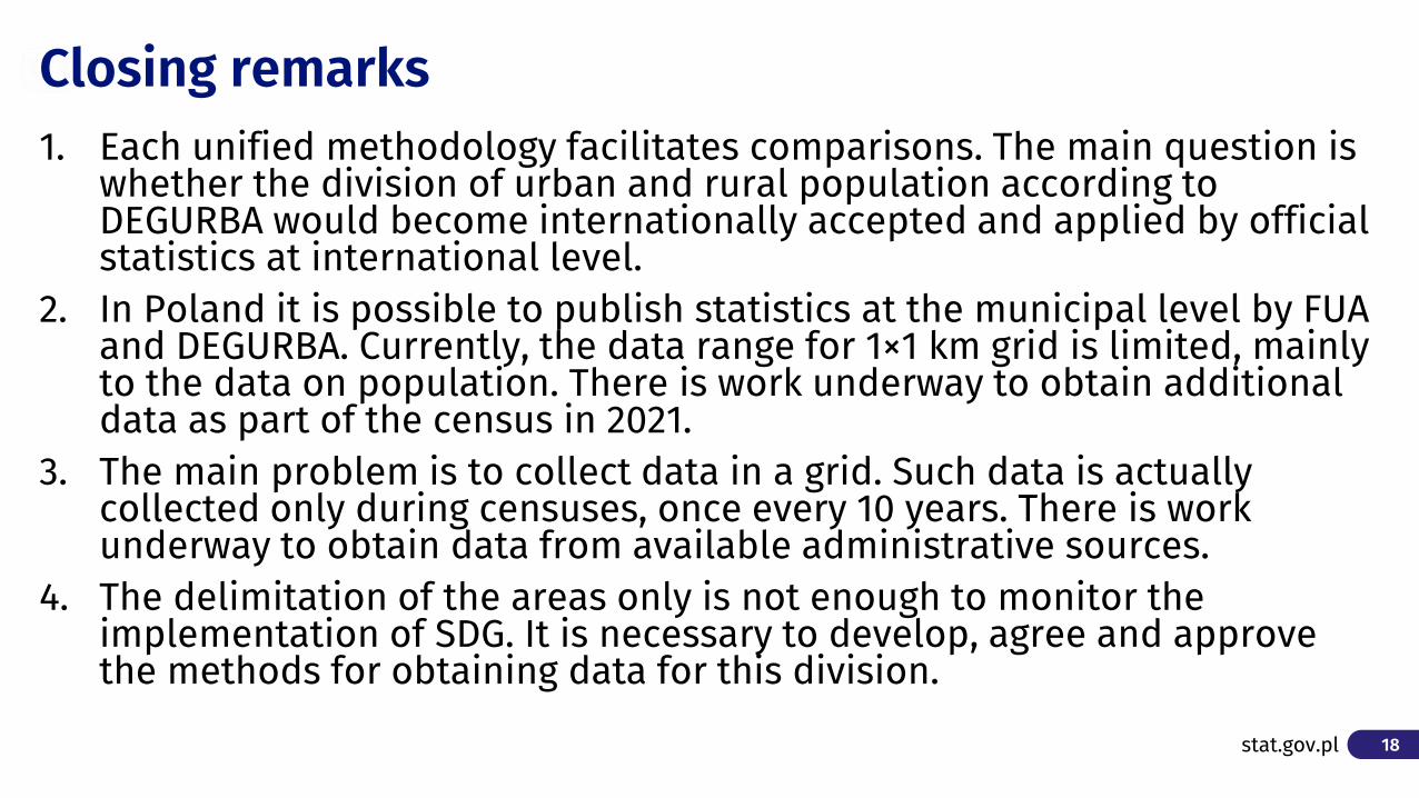
1. Each unified methodology facilitates comparisons. The main question is whether the division of urban and rural population according to DEGURBA would become internationally accepted and applied by official statistics at international level.
2. In Poland it is possible to publish statistics at the municipal level by FUA and DEGURBA. Currently, the data range for 1×1 km grid is limited, mainly to the data on population. There is work underway to obtain additional data as part of the census in 2021.
3. The main problem is to collect data in a grid. Such data is actually collected only during censuses, once every 10 years. There is work underway to obtain data from available administrative sources.
4. The delimitation of the areas only is not enough to monitor the implementation of SDG. It is necessary to develop, agree and approve the methods for obtaining data for this division.
Closing remarks
19stat.gov.pl
Spatial and Environmental Surveys DepartmentDominika Rogalińska
Thank you for your attention
Recommended