Deepwater Horizon Oil Spill (DWHOS)Water Column Technical Working Group
NRDA Spring 2011 Plankton imaging Sampling Cruise Plan
Sampling Vessel: RA ̂Oceanus
January 30, 2011 Revised: March 8, 2011
Prepared by:Deborah French-McCay, Eileen Graham (ASA) and Cabeii Davis (W HOI) on behalf o f the
Trustees Reviewed by:
Dan Hahn. John Quinlan (NOAA) and Amanda Vincent (LA) on behalf o f the Trustees William Graeber, Jeffery Simms (Cardno ENTRIX), Mark Benfield (LSU) on behalf o f BP
Proposed C ruise DatesMarch 1 - April 18, 2 0 II
B a ck grou n d /Ju stifica tionC oncep tual M odel - W a te r C olum n O rganism s
The trustees have developed a preliminary conceptual model o f the DW H release, potential patlnvays and routes o f exposure, and potential receptors. This prelim inary model has informed the trustees ’ decision to pursue the studies outlined in the work plan. By sipping this work plan and agreeing to fund the work outlined, BP is not endorsing the model articulated in the work plan.
Release and PathwayOil released from the broken well head both dispersed at depth and rose through nearly a mile o f water column. T he composition o f the released gas-liquid mixture changed over tim e and space as the result of dilution, changes in pressure, dissolution, and addition o f other constituents such as dispersants, methanol, and anti-foaming additives. O f oil that made it to the water surface, some entrained water forming mousse, was dispersed into the water column naturally and by application o f dispersants, and some was removed mechanically or by in situ burning. Floating oil, oil droplets, flocculated and dissolved com ponents were transported large distances at various levels o f the water column. Oil also picked up sediments, and other particulate material, some o f which became neutrally or slightly negative buoyant, sinking to various depths. The oil dispersed at the wellhead (both via turbulence or by injection o f dispersants) was transported by currents that varied in time and space, yielding a com plex pathway of subsurface oil contamination that affected abyssal, bathy pelagic, and meso-pelagic waters o f the offshore G ulf o f M exico.
Routes o f ExposureFish and invertebrates in the water column are exposed to contaminants by swimming through contam inated water, spending tim e on/in contaminated sediments, taking up contaminants through body surfaces, passing contaminated water over respiratory structures, and ingesting water, oil droplets, contam inated biota, and particulates contaminated with oil as part o f feeding. Additionally, sensitive life stages o f pelagic tlsh and invertebrates come in direct contact w ith floating oil that covers and is mixed
1 II 11 I '
DWH-AR0226821
into the neuston layer {upper ~0.5m) where many em bryos and larvae develop. O ther neustonic organisms exposed to surface oil include many small invertebrates important to the food web. in the water column, organisms are also exposed to suspended oil droplets, which can foul appendages or other body surfaces. Water column organisms have also been exposed to dispersants dissolved in water, on oil droplets and adsorbed to suspended particulate matter. W ater column organisms were also exposed to dissolved and water-borne chemical additives such as methanol and anti-foaming agents.
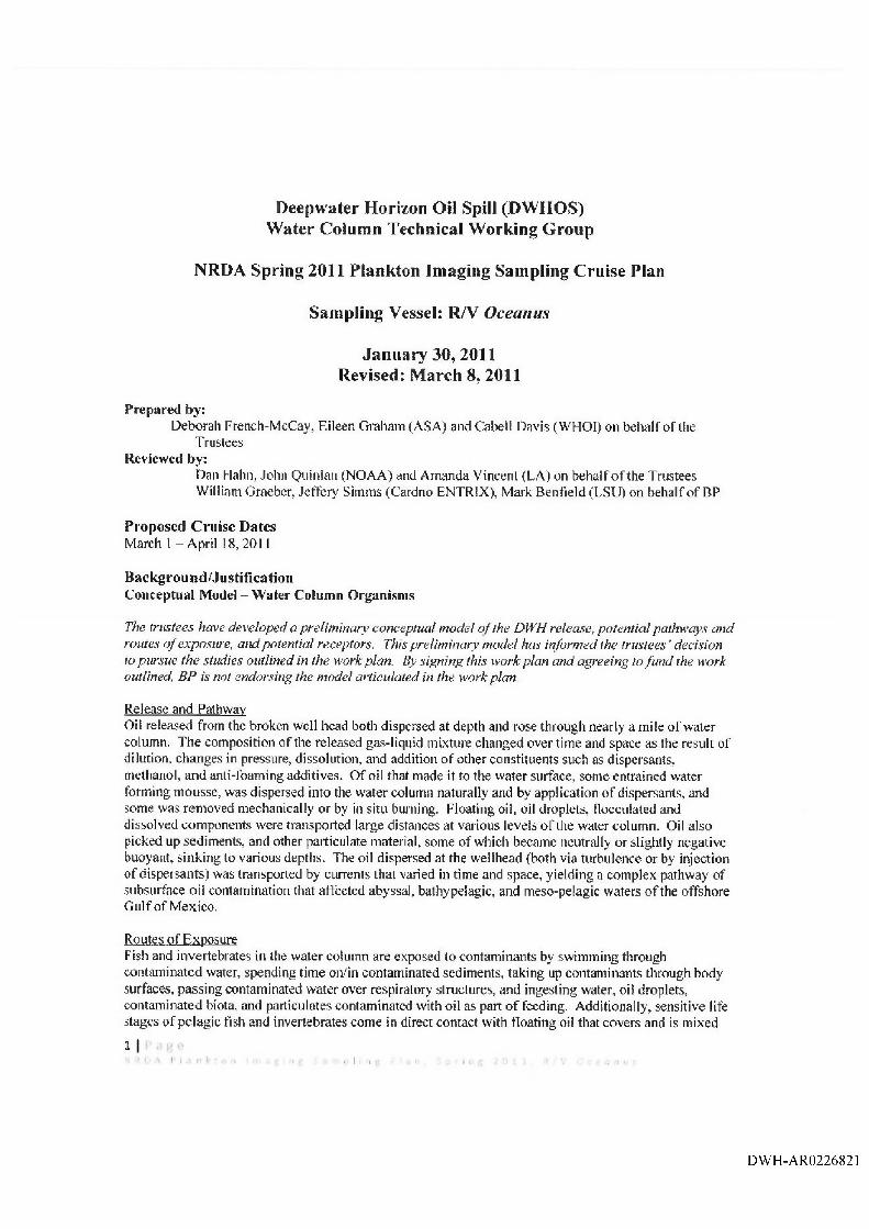
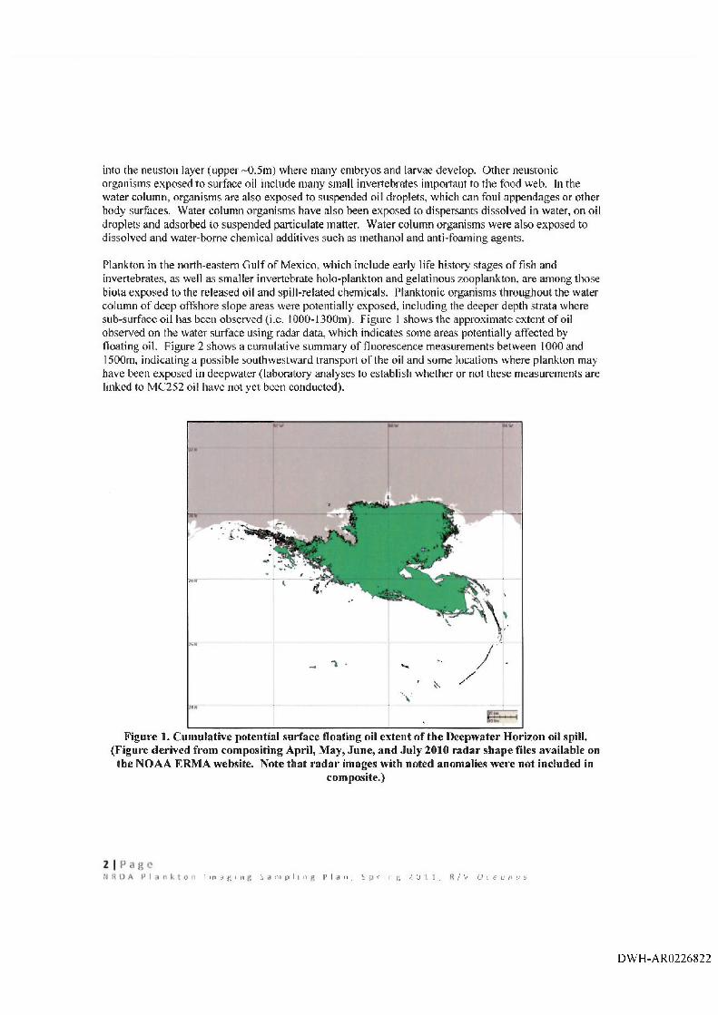
Plankton in the north-eastern G ulf o f Mexico, which include early life history stages o f fish and invertebrates, as well as smaller invertebrate holo-plankton and gelatinous zooplankton, are am ong those biota exposed to the released oil and spill-related chemicals. Planktonic organisms throughout the water column o f deep offshore slope areas were potentially exposed, including the deeper depth strata where sub-surface oil has been observed (i.e. 1000-1300m). Figure 1 shows the approximate extent o f oil observed on the water surface using radar data, which indicates some areas potentially affected by floating oil. Figure 2 shows a cumulative summ ary o f fluorescence measurements between 1000 and 1500m, indicating a possible southwestward transport o f the oil and some locations where plankton may have been exposed in deepwater (laboratory analyses to establish whether or not these measurements are linked to MC252 oil have not yet been conducted).
Figure 1. Cum ulative potential surface floating oil extent of the Deepwater Horizon oil spill. (Figure derived from com positing April, M ay, June, and July 2010 radar shape files available on
the NO AA ERM A website. Note that radar images with noted anomalies were not included incom posite.)
1 i n ^ g i n S n i p I i 11 p | n , S f i n fj ? 0 L 1 , / V O c e ij n u b
DW H-AR0226822
M ap Date: 3 O ctober 2010 A q u a tra c k a F h io ro m e tr> '(L 0 € 0 - ISOO M ete r D e p th s)
Data cumulative from IS Aueu^to 30 September 2010 Deepwater Horizon Response, Gulf of Mexico■rww .. jfvtk rwrt*
t 1, _ ----------------------------U ------ ---------------------------1-------------------vfmv ee KfV HI—--------1----------------------- f-----------------------1---------- ,
Figure 2. Cum uiative sum m ary o f Aquatracka fluorescence m easurements between 1000 and1500m, 15 August to 30 Septem ber 2010.
O b jectives and A pp roachThis plan is part o f a series o f cruises scheduled for the spring o f 2 0 II intended to evaluate the distribution and densities o f ichthyoplankton, other zooplankton and some phytoplankton {> ~50pm ) in G ulf o f M exico waters potentially affected by the Deepwater Horizon Oil Spill (DW HOS) and in surrounding areas. The over-arching plankton plan is to conduct sam pling in each season, utilizing several sam pling methods (e.g. bongo net, neuston net, Multiple Opening/Closing Net and Environmental Sensing System (M OCNESS), and imaging systems). The duration o f the program, with respect to the number o f seasons and years, is to be determined. Because plankton are transported over wide areas, and populations are connected across the northern G ulf o f M exico, sampling plans need to be broad in geographic scope.
Plankton in the upper 200m o f the water column o f the G ulf o f Mexico from Texas to Florida have been sampled by the NMFS/NOAA SEAM AP program over the past 25 years (Attachment 9), The overall NRDA plankton sampling plan takes advantage o f this historical data set and plans for continuation and extension o f the NMFS Southeast Fisheries Science Center (SEFSC) SEAM AP program into deep water areas where the spill took place. The station spacing o f the SEAM AP and NRDA sam pling grids is extensive, but is sparse compared with the high-resolution sampling capabilities o f new optical imaging systems and the high-resolution data needed for initializing and validating coupled biological-physical numerical models o f the pelagic ecosystem. The second generation V ideo Plankton Recorder (VPRII) (Appendix 10) is able to rapidly survey plankton with very high horizontal and vertical spatial resolution, i.e., at the same resolution as the physical and environmental variables (CTD, fluorescence, PAR,
3 I P a g eN H O A P l a n k t o n I m i l g j i l f ! S i i m p l i n g P l i i n , S p r i n i ' 2 0 1 1 , R / V O c e a n u s
DWH-AR0226823
turbidity, dissolved oxygen). This sam pling allows direct comparison o f plankton and their environment over scales from centim eters to 1,000s o f kilom eters (Davis et al„ 1992; Davis and M cGillicuddy, 2006).
A series o f cruises in the fall o f 2010 (aboard Walton Smith and HOS Davis) used the digital autonomous video plankton recorder (DA VPR) to sam ple fragile and other plankton and marine snow in the deeper slope sea from the surface to near bottom. Comparative studies between plankton imaging systems and traditional net-based sampling techniques have been carried out by various investigators (i.e. Broughton and Lough, 2006) and paired M OCNESS-DAVPR sam pling was conducted during January 2011 in joint ship operations aboard the Arctic and Nick Skansi. These two types o f sampling systems have been found to be comparable in quantifying hardy plankton that can withstand net sampling. Fragile organisms and particles such as smalt gelatinous organisms (including many larvae) and marine snow are easily identified and quantified using imaging systems, whereas these delicate groups are destroyed or damaged beyond recognition in net samples.
The primary objective o f the proposed Spring 2 0 11 R/V Oceanus plankton imaging sam pling cruise is to collect high-resolution data on plankton and marine snow together with environmental variables using the VPRII, A high-speed survey o f the shelf and slope waters o f the northern G ulf o f M exico will be conducted, with the transect lines running through the standard SEAM AP stations and extending beyond them into the slope and offshore areas (Figure 3), It is expected that the proposed sam pling will help enable quantification o f some characteristics o f the plankton communities, such as occurrence, abundance, biomass, and vertical distribution o f plankton and marine snow; together with ocean temperature, salinity, chlorophyll fluorescence, PAR, and turbidity in the G ulf o f Mexico. This sam pling will allow direct comparison o f data from traditional samplers used in the SEAMAP surveys and the current NRDA MOCNESS surveys with optical imaging o f the VPRII. The VPRII sampling will extend the spatial resolution o f the present sam pling and will allow quantification o f fragile plankton and marine snow in the upper water column. It will also allow for comparison between deeper DAVPR sam pling to provide a more complete assessment o f the water column (i.e. the VPRII is depth limited and the DAVPR cannot sam ple the region as efficiently; com bined the data sets may be able to provide a complete representation o f plankton and marine snow in the water column). The VPRII may be towed at higher tow speeds (i.e. 10-12 knots) than the DAVPR (2-4 knots), and so it was selected to perform semi-synoptic sampling over a w ide area. It is expected that the sampling data may be used to help inform estimates o f plankton com munity characteristics including abundance, distribution and biomass input data for the injury assessment. The descriptions o f the analyses for those estimates are beyond the scope o f this sampling plan.
This plan, the Spring 2011 R/V Oceanus plankton imaging sampling plan, describes the sampling effort for March 8 - April 9, 2011. The cruise plan covers March 1 - April 1 8 ,2 0 11 to account for the eight day transit to/from W oods Hole Oceanographic Institute, Massachusetts.
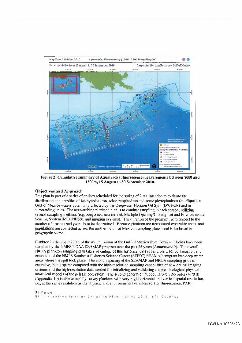
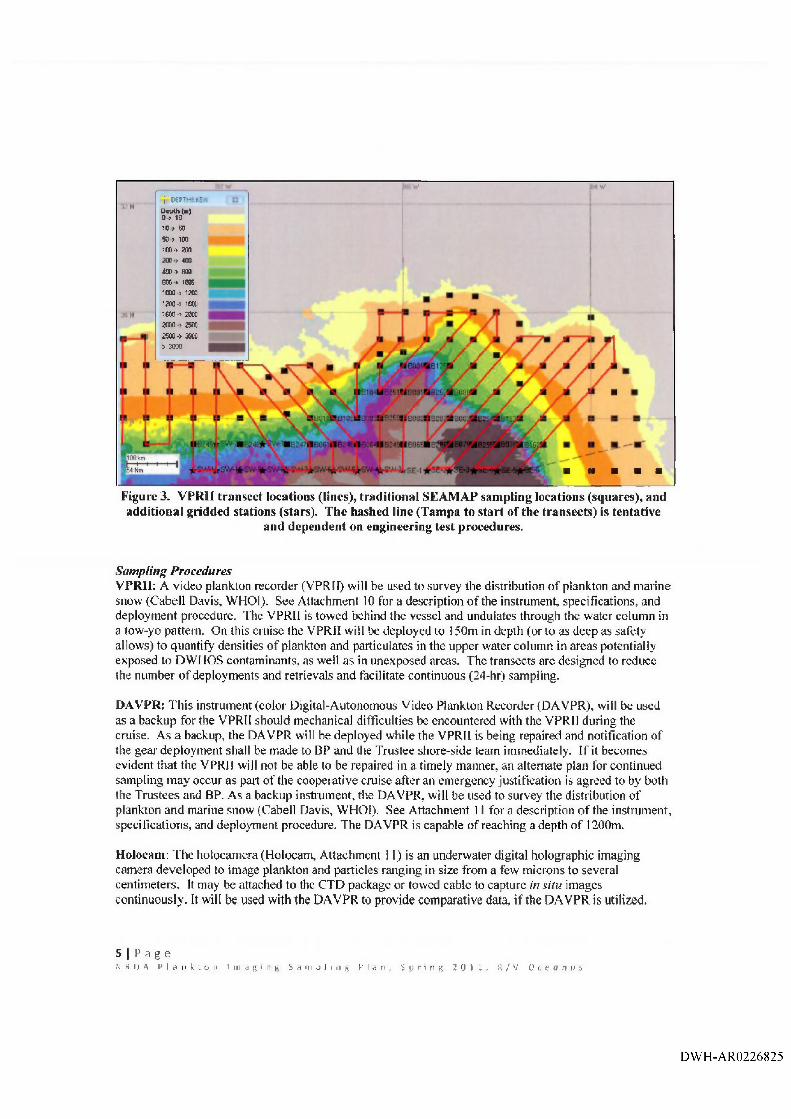
M ethodology Sampling TrattsectsThe VPRII will be towed along continuous transects that run roughly perpendicular to the depth contours o f the continental slope and through SEAM AP gridded stations (Figure 3). Specific locations o f the transects may be adjusted slightly for logistical or safety reasons
4 |
DW H-AR0226824
f 'j DfPTujyC
Depth (■)D > IQ10 > 5050 > 100im-> 200
400 ■> 800800 > inn1 (^ 0 12001200 o 10» L _ n1COO’> 20002000 25002500 -> 3000> 3000
LFigure 3. VPRII transect locations (lines), traditional SEAM AP sam pling locations (squares), and additional gridded stations (stars). The hashed line (Tampa to start o f the transects) is tentative
and dependent on engineering test procedures.
Sampling ProceduresV PR II; A video plankton recorder (VPRII) will be used to survey the distribution o f plankton and m arine snow (Cabell Davis, WHOI), See Attachment 10 for a description o f the instrument, specifications, and deployment procedure. The VPRII is towed behind the vessel and undulates through the water column in a tow-yo pattern. On this cruise the VPRII will be deployed to 150m in depth (or to as deep as safety allows) to quantify densities o f plankton and particulates in the upper water column in areas potentially exposed to DW HOS contaminants, as well as in unexposed areas. The transects are designed to reduce the number o f deployments and retrievals and facilitate continuous (24-hr) sampling.
DA VPR: T his instrument (color Digital-Autonomous Video Plankton Recorder (DAVPR), will be used as a backup for the VPRII should mechanical difficulties be encountered with the VPR 11 during the cruise. As a backup, the DAVPR will be deployed while the VPRII is being repaired and notification of the gear deployment shall be made to BP and the Trustee shore-side team immediately. If it becomes evident that the VPRII will not be able to be repaired in a timely manner, an alternate plan for continued sampling may occur as part o f the cooperative cruise after an emergency justification is agreed to by both the Trustees and BP. A s a backup instrument, the DAVPR, will be used to survey the distribution o f plankton and marine snow (Cabell Davis, WHOI). See Attachment 11 for a description o f the instrument, specifications, and deployment procedure. The DAVPR is capable o f reaching a depth o f 1200m.
Holocam: The holocamera (Holocam, Attachment 1 1) is an underwater digital holographic imaging camera developed to image plankton and particles ranging in size from a few microns to several centimeters. It may be attached to the CTD package or towed cable to capture in situ images continuously. It will be used with the DAVPR to provide comparative data, i f the DAVPR is utilized.
5 I P a g e.N H n A P l a n k t o n 1 i n a R I II {J S a ni p J i 11 g P l a n , S p r i n g 2 0 1 1 , R / V 0 r; e p p s
DWH-AR0226825
CTD: The VPRII has Seabird CTD, fliiorometer, optical backscatter, and photosyntheticaliy active radiation (PA R) sensors internally mounted to record environmental characteristic concurrently with the images. The DAVPR does not and therefore will be mounted on the Seabird SB E911 + CTD profiling package to collect high-resolution water characterization data. The following sensors are to be deployed with this package, as logistically feasible: chlorophyll fluorometer, transm issometer, PAR, dissolved oxygen, and salinity, temperature, and depth information.
R etention o f M ateria ls: All materials associated with the collection or analysis o f samples under these protocols or pursuant to any approved work plan, except those consumed as a consequence o f tiie applicable sam pling or analytical process, must be retained unless and until approval is given for their disposal in accordance with the retention requirem ents set forth in paragraph 14 o f Pretrial Order # I (issued A ugust 10, 2010) and any other applicable Court Orders governing tangible items that are or may be issued in MDL No. 2179 IN RE: Oil Spill by the Oil Rig "DEEPW ATER HORIZON" (E.D. LA 2010). Such approval to dispose must be given by a person authorized to direct such action on behalf o f the state or federal agency whose employees or contractors are in possession or control o f such materials.
D ata M anagem ent an d T ru s tee O versigh t: All profile, acoustic, and other electronic data will be saved to an on-board computer, and all data shall be migrated to a dedicated hard drive. The data will be controlled and managed by the trustees under project protocols, including Chain-of-Custody tracking o f the hard drive. The hard drive will be duplicated in full immediately following the cruise, and the duplicate hard drive will be provided to Cardno ENTRIX on behalf o f BP. The original hard drive shall be kept in a secure facility in trustee custody.
Under the direction o f the Chief Scientist, a NOAA Data M anager on board each vessel will summarize sampling activities and scientific observations throughout the day and email a daily report to a designated list o f recipients and NOAA NRDA (dwhnrdaW C@ gmail.com) by midnight each day o f the cruise.
In addition, Cardno ENTRIX will use an internal data management system to store, manage and process data from all study elements. This system will accom modate all chemistry and quality assurance data in formats com patible with BP’s centralized database. A data management plan will be prepared to document the systems and procedures that will be used to ensure that data quality and data integrity are maintained throughout data management processes (Attachment 7).
L ogisticsVessel;Operations will be completed on the R/V Oceanus. This vessel will be utilized because the VPRII system requires a specialized winch and cable with fairing in order to sample at high speeds. This system has been used on the Oceanus many times and the full unit (VPRII, winch, cable) can be transported onboard the Oceanus to the sampling locations.
Cruise Schedule:T a b le 1. P roposed schedu le for R /V O ceanus V PR cru ise
2 /26-2 /28/2011 S etup and test sam pling system s on R /V O ceanus3/1/2011 R/V O ceanus d eparts W H O I3/7/2011 R/V O ceanus A rrives T am pa, FL3/8/2011 F inal m o b iliza tio n on O ceanus T am pa, FL3/9/2011 R/V O ceanus D eparts T am pa, FL3/19/2011 R/V O ceanu s A rriv e s P anam a C ity , FL3/19/2011 P ersonnel exchange
6 I
DW H-AR0226826
3/19/2011 R /V O ceanus D eparts P anam a C ity , FL4/8/2011 R /V O ceanus A rriv es G alveston , T X4/10/2011 R/V O ceanus D eparts G alveston , T X4/18/2011 R /V O ceanus a rriv es W HOI
Personnel fo r R/V Oceanus:WHOI Contractors;
Dr. Cabell Davis, C hief Scientist Fredrik Thwaites, VPR Engineer Phil Alatalo, VPR Technician TBD, Research Assistant
NRDA Contractors:VPR Technician (Leg 1: Kate Lingoni, Leg 2: Fred Marin) D ata M anager (Dade Moeller)
Cardno ENTRIX Employees;2 (Observers, one on each cruise leg)
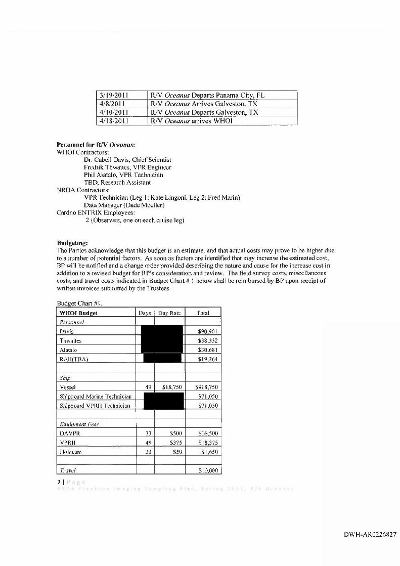
Budgeting;The Patties acknow ledge that this budget is an estimate, and that actual costs may prove to be higher due to a number o f potential factors. As soon as factors are identified that may increase the estimated cost, BP will be notified and a change order provided describing the nature and cause for the increase cost in addition to a revised budget for BP’s consideration and review. The field survey costs, miscellaneous costs, and travel costs indicated in Budget Chart # 1 below shall be reimbursed by BP upon receipt o f written invoices submitted by the Trustees.
Budget Chart #1.W HOI Budget Days 13ay Rate Total
Personnel
Davis $90,901
Thwaites $38,332
Alatalo $30,681
RAIl(TBA) $19,264
Ship
Vessel 49 $18,750 $918,750
Shipboard Marine Technician $71,050
Shipboard VPRII Technician $71,050
Equipment Fees
DAVPR 33 $500 $16,500
VPRII 49 $375 $18,375
Holocam 33 $50 $1,650
Travel $10,000
7 |I • 1
DW H-AR0226827
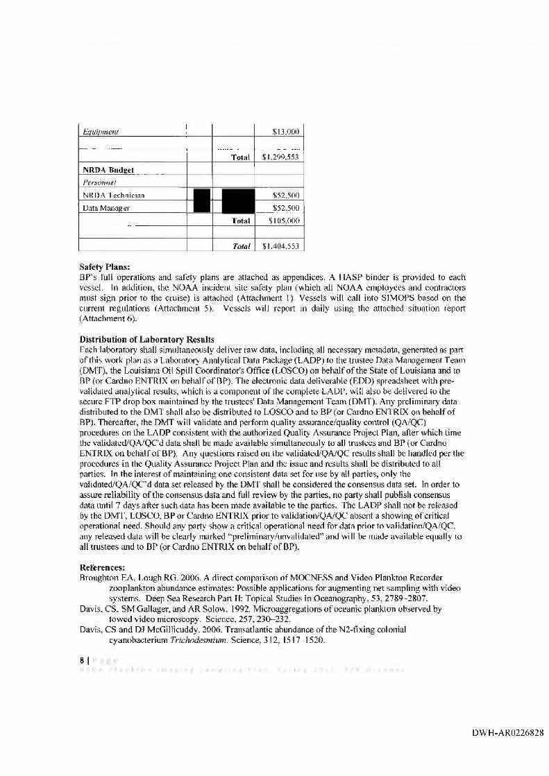
Equipment £13,000
Total $1,299,553
NRDA Budget
Personnel
NRDA Technician £52,500
Data Manager $52,500
Total $105,000
Total $1,404,553
Safety P lans:BP’s fuii operations and safety plans are attached as appendices. A HASP binder is provided to each vessel. In addition, the NOAA incident site safety plan (which all NOAA em ployees and contractors must sign prior to the cruise) is attached (Attachment I). Vessels will call into SIMOPS based on the current regulations (Attachment 5), Vessels will report in daily using the attached situation report (Attachment 6).
Distribution o f Laboratory RestiltsEach laboratory shall simultaneously deliver raw data, including all necessary metadata, generated as part o f this work plan as a Laboratory Analytical Data Package (LADP) to the trustee Data M anagement Team (DMT), the Louisiana Oil Spill Coordinator's Office (LOSCO) on behalf o f the State o f Louisiana and to BP (or Cardno ENTRIX on behalf o f BP). The electronic data deliverable (EDD) spreadsheet with prevalidated analytical results, which is a com ponent o f the complete LADP, will also be delivered to the secure FTP drop box maintained by the trustees' Data Management Team (DMT). Any preliminary data distributed to the DM T shall also be distributed to LOSCO and to BP (or Cardno ENTRIX on behalf o f BP). Thereafter, the DMT will validate and perforin quality assurance/quality control (QA/QC) procedures on the LADP consistent with the authorized Quality Assurance Project Plan, after which time the validated/QA/QC'd data shall be made available simultaneously to all tnistees and BP (or Cardno ENTRIX on behalf o f BP). Any questions raised on the validated/QA/QC results shall be handled per the procedures in the Quality Assurance Project Plan and the issue and results shall be distributed to all parties. In the interest o f maintaining one consistent data set for use by all parties, only the validafed/QA/QC’d data set released by the DM 'f shall be considered the consensus data set. In order to assure reliability o f the consensus data and full review by the parties, no party shall publish consensus data until 7 days after such data has been made available to the parties. The LADP shall not be released by the D M T, LOSCO, BP or Cardno ENTRIX prior to validation/QA/QC absent a showing o f critical operational need. Should any party show a critical operational need for data prior to validation/QA/QC, any released data will be clearly marked “■preliminary/unvalidated” and will be made available equally to all trustees and to BP (or Cardno ENTRIX on behalf o f BP).
R eferences:Broughton EA, Lough RG. 2006. A direct com parison o f MOCNESS and Video Plankton Recorder
zooplankton abundance estimates: Possible applications for augmenting net sampling with video system s. Deep Sea Research Part II: Topical Studies in Oceanography, 53, 2789-2807,
Davis, CS, SM Gallager, and AR Solow. 1992. M icroaggregations o f oceanic plankton observed by tow ed video microscopy. Science, 257 ,230-232 ,
Davis, CS and DJ McGillicuddy. 2006. Transatlantic abundance o f the N 2-fixing colonial cyanobacterium Trichodesmium. Science, 312, 1517—1520.
8 |
DWH-AR0226828
A ttachm en ts:Attachment 1 . NRDA_Ops_Safety_Plaii_08DEC2010Attachment 2. MC252 HSSE Incident Reporting Final 02 May 10 rev 1Attachment 3. CSA-Davis HSE Plan Rev 005_Final Attachment 4. Transfer o f Personnel and Material at Sea 070510 Attachment 5. NRDA SIMOPS Procedures 111710 Attachment 6. DW H Vessel Daily SitRep Attachment 7. MC252 Analytical QAP V 2 .1Attachment 8. NRDA_Field_Sampler_Data_M anagement_Protocol_ 10_23_2010 Attachment 9. Historical Plankton D ata_2010A ugl7 Attachment 10. CDavis-VPRll-201 !Jan30 Attachment 11. COavis-VPR Holop-aphy-2010Dec9
DW H-AR0226829
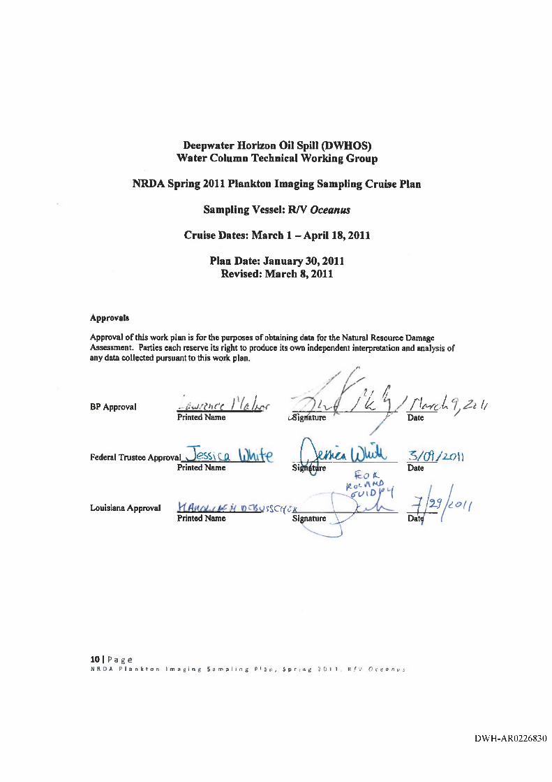
Deepwater Horizon Oil Spill (DWHOS)Water Column Technical Working Group
NRDA Spring 2011 Plankton Imaging Sampling Cruise Plan
Sampling Vessel: RA ̂Oceanus
Cruise Dates: March 1 - April 18,2011
Plan Date: January 30,2011 Revised: March 8,2011
Approvals
Approval o f this work plan is for the purposes of obtaining data for the Natural Resource Damage Assessment. Parties each reserve its right to produce its own independent interpretation and analysis of any data collected pursuant to this work plan,
/ ̂ ̂ / jBP Approval J k , r w i 1/
Printed Name vSigifeture A Date
Federal Trustee Approval JfiSSxCJX J V ito 5/c^yzonPrinted Name Si^atpre ^ Date
ILlg.r/L
Louisiana Approval sSO((Ti________ V ^ ^ j ' ^Printed Name Signature \ y ' Data
10 I P a g eN R D A P t a n k t o n I m a g i n g S a m p l i n g P l a n , S p r i n g 2 0 1 1 r / V O c e o n i j j
DW H-AR0226830
Recommended