Towards We-Government: Collective and participative approaches for
addressing local policy challenges
Grant Agreement number: 693514
Deliverable
D3.3
First release of WeGovNow
platform prototype
Project co-funded by the European Commission within H2020-EURO-2014-2015/H2020-EURO-6-2015
Dissemination Level
PU Public
PP Restricted to other programme participants (including the Commission Services
RE Restricted to a group specified by the consortium (including the Commission Services
CO Confidential, only for members of the consortium (including the Commission Services)

D3.3 First release of WeGovNow platform prototype
2
Author List
Organisation Name Contact Information
UniTo Alessio Antonini [email protected]
UniTo Liliana Ardissono [email protected]
LiquidFeedback Jan Behrens [email protected]
UniTo Guido Boella [email protected]
UniTo Luigi Di Caro [email protected]
Infalia Elena Dougia [email protected]
UCL Carles Boils Gisbert [email protected]
MfC Louise Francis [email protected]
LiquidFeedback Axel Kistner [email protected]
Empirica Lutz Kubitschke [email protected]
PoliTo Luigi La Riccia [email protected]
UniTo Maurizio Lucenteforte [email protected]
UniTo Lucia Lupi [email protected]
UniTo Roberto Micalizio [email protected]
Infalia Alexandros Mokkas [email protected]
LiquidFeedback Andreas Nitsche [email protected]
UniTo Giovanna Petrone [email protected]
UniTo Adriano Savoca [email protected]
UniTo Claudio Schifanella [email protected]
UniTo Marino Segnan [email protected]
LiquidFeedback Björn Swierczek [email protected]
Infalia Ioannis Tsampoulatidis [email protected]
PoliTo Angioletta Voghera [email protected]
D3.3 First release of WeGovNow platform prototype
3
Status, Abstract, Keywords, Statement of originality
Dissemination level: Public
Deliverable No. 3.3
Leading Partner UniTo
Participating Partners LiquidFeedback, Infalia, UCL, Mapping for
Change
Contractual date of delivery: 31 Apr 2017
Actual date of delivery: 20 May 2017
Work Package: WP3 – Agile Development of the
WeGovNow platform
Type: Report
Approval Status: Final
Version: 1.0
Abstract
This document describes the first release of WeGovNow platform prototype
Keywords
Prototype, Platform, Functionalities
Statement of originality
The information in this document reflects only the author’s views and the
European Community is not liable for any use that may be made of the information
contained therein. The information in this document is provided as is and no
guarantee or warranty is given that the information is fit for any purpose. The user
thereof uses the information at its sole risk and liability.
D3.3 First release of WeGovNow platform prototype
4
History
Version Date Reason Revised by
1.0 20.04.2017 Creation of the initial document structure
Alessio Antonini
26.04.2017 Structure of contributions Alessio Antonini
02.05.2017 LandingPage, new structure, general description of prototype
Alessio Antonini
5.05.2017 GeoKey / CommunityMap Carles Boils Gisbert, Alessio Antonini
5.05.2017 OntoMap
Liliana Ardissono, Adriano Savoca, Angioletta Voghera, Luigi La Riccia, Alessio Antonini
8.05.2017 Integration status and documentation
Alessio Antonini
8.05.2017 Style service, introduction Alessio Antonini
8.05.2017 InputMap Alessio Antonini
8.05.2017 FirstLife Alessio Antonini, Lucia Lupi
8.05.2017 Revision of GeoKey / CommunityMap section
Carles Boils Gisbert, Alessio Antonini
9.05.2017 NavigationBar, Accessibility Settings, User Settings
Alessio Antonini
9.05.2017 FirstLife guides and applicative scenarios
Alessio Antonini, Lucia Lupi
9.05.2017 UWUM section Alessio Antonini
9.05.2017 Introduction to Guides and Resources
Alessio Antonini
10.05.2017 Revision of GeoKey / CommunityMap section
Carles Boils Gisbert, Louise Francis
10.05.2017 Revisions Ch.1-2 Louise Francis, Alessio Antonini
10.5.2017 UWUM integration, Authentication Server, Style Service endpoint
Alessio Antonini
14.05.2017 LiquidFeedback sections Axel Kistner, Andreas Nitsche
15.05.2017 Integration of LiquidFeedback and Authentication Server contributions
Alessio Antonini
15.05.2017 Fix GeoKey and Community Map screenshots
Alessio Antonini
V1.1 15.05.2017 Section 5 future development, ongoing components moved to section 5
Alessio Antonini
15.05.2017 AreaViewer Alessio Antonini
D3.3 First release of WeGovNow platform prototype
5
Version Date Reason Revised by
15.05.2017 Exhibit 1: table of components, modules, features
Alessio Antonini
15.05.2017 LiquidFeedback examples, section 2.4
Axel Kistner, Andreas Nitsche
15.05.2017 Seamless integration, section 1.2
Alessio Antonini
16.05.2017 Finalising and fine tuning IMC and TMP section
Ioannis Tsampoulatidis, Elena Dougia, Alexandros Mokkas
16.05.2017 Fix of captions, exhibits and references
Alessio Antonini
18.05.2017 Proof reading Claudio Schifanella
V1.2 18.05.2017
New introduction, restructuring of the introduction (current section 2), headings
Lutz Kubitschke
18.05.2017 Formatting, new table of contents, headings, references
Alessio Antonini
18.05.2017 Executive summary Lutz Kubitschke
D3.3 First release of WeGovNow platform prototype
6
Contents
Executive Summary ......................................................................................................... 7
1. Introduction ............................................................................................................. 10
2. Overview of the integration work achieved so far .................................................... 12
3. Description of existing components integrated into the platform prototype (v1) .... 15
3.1. GeoKey & CommunityMap ......................................................................................... 15 3.2. FirstLife ....................................................................................................................... 16 3.3. ImproveMyCity ........................................................................................................... 17 3.4. LiquidFeedback ........................................................................................................... 19
4. Level of integration achieved in relation to existing and newly developed
components ............................................................................................................. 22
4.1. LandingPage ................................................................................................................ 24 4.2. Authentication Server ................................................................................................. 25 4.3. GeoKey and Community Maps ................................................................................... 27 4.4. FirstLife ....................................................................................................................... 32 4.5. ImproveMyCity ........................................................................................................... 34 4.6. LiquidFeedback ........................................................................................................... 38
5. Description of platform services ............................................................................... 40
6. Ongoing development work ..................................................................................... 55
6.1. User Management ...................................................................................................... 55 6.2. Accessibility Settings ................................................................................................... 56 6.3. AreaViewer ................................................................................................................. 57 6.4. Trusted Marketplace .................................................................................................. 58
Annexes ........................................................................................................................ 61

D3.3 First release of WeGovNow platform prototype
7
Executive Summary
In a nutshell, WeGovNow strives for integrating a set of innovative software
applications into a unified citizen engagement platform. In doing so the project aims
at overcoming current limitations of existing digital tools for citizen reporting, e-
participation, and communication between the citizen and the public administration.
To this end, a number of civic engagement applications that have already existed
prior to the project are to be integrated into a single online platform together with
software components to be newly developed.
With a view to facilitating the utilisation of the WeGovNow platform within different
local contexts, individual implementation instances are to be configurable in a
modular manner. Also, the new WeGovNow engagement platform is to be
principally extendable with further applications which potentially may be desired to
be added in future implementation instances. Such a multi-faceted set of basic
requirements poses a number of challenges for the design of the WeGovNow
platform, in particular when it comes to
the development cycle and design process which is to involve a variety of
stakeholders at the three pilot cities participating in WeGovNow,
and the achievement of a coherent user experiences across a diverse range of software components to be integrated into a single online platform, including existing ones and newly developed ones.
Against this background, a multi staged development approach has been adopted for
the purposes of WeGovNow. As graphically summarised in the schema below, four
main phases can be discerned, starting with a thorough consolidation of the initial
platform architecture (D3.1) and the development of suitable testing protocols
(D3.2) to be utilised throughout the subsequent development phases.
WeGovNow platform development phases.
This was followed by basic integration work (Phase II) mainly focussing on the
seamless interoperation of those software components that have already existed
prior to WeGovnow, e.g. in terms of a unified user management solution. The
Platform architecture & testing protocol
development
Basic component integration
Iterative prototype refinement &
extension
Platform piloting under day to day
conditions
consolidated platform architecture (D3.1)
&testing protocols
(D3.2)
v1 platform prototype
(D3.3)
pilot platform
(D3.5)
v2 platform prototype
(D3.4)
Phase I Phase II Phase III Phase IV
D3.3 First release of WeGovNow platform prototype
8
current report (D3.3) presents a paper based description of the 1st version prototype
of the WeGovNow platform as an outcome of this development phase.
During the next development phase (Phase III), the current prototype version will be
further developed in an iterative manner within experimental settings, thereby
involving a diverse range of stakeholders in three cities participating in the project.
This will yield the final version of the fully tested platform which is then to be piloted
under everyday conditions with large numbers of users (Phase IV).
The first release of the WeGovNow prototype platform is provided as a “working”
environment for:
- Development purposes (https://dev.wegovnow.eu)
- Testing and presentation purposes (https://sandbox.wegovnow.eu)
To support the involvement of stakeholders at the three WeGovNow pilot sites
during the next stage of platform development (Phase III) dedicated prototype
implementation instances are provided to each of the three sites:
- San Donà di Piave (https://sandona.wegovnow.eu)
- Southwark (https://southwark.wegovnow.eu)
- Torino (https://torino.wegovnow.eu)
From a development angle, the WeGovNow platform prototype - as it currently
stands - provides an environment of various internal services (core features)
required to run a WeGovNow instance, including smooth interoperation of various
stand-alone web components (WeGovNow components) integrated into the overall
platform.
A local WeGovNow implementation instance can be configured to use any
combination of modular components, enabling cross-component features according
to the combination of active components.
From the perspective of the end users, the current version of the prototype platform
provides a number of functionalities through the integration of components that
have existed prior to WeGovNow already, including:
- Map-based social networking functionalities realised by means of integrating
FirstLife;
- Citizen reporting functionalities realised through the integration of
ImproveMyCity;
- Opinion formation and voting functionalities realised through the integration
of LiquidFeedback.
- Community mapping functionalities realised by means of integrating
Community Map and GeoKey
When it comes to interface integration in particular, the approach adopted for the
purposes of WeGovNow can be characterised as a gradual convergence toward a
well-documented design framework (Material Design https://material.io/), a
D3.3 First release of WeGovNow platform prototype
9
repository to collect common solutions to shared design issues, and a set of features
supporting the propagation of user setups, customisations and elements among
WeGovNow components. This approach provides a pragmatic solution to the need
for providing a coherent user experience across the platform while at the same time
taking into account that changing the interface design of existing components is
much more complex and resource consuming (and thus costly) when compared with
newly developed components. Also, the design approach adopted for the purpose of
WeGovNow helps in keeping the platform as open as possible towards additional
components that may be desired to be integrated after the ending of the project
duration.
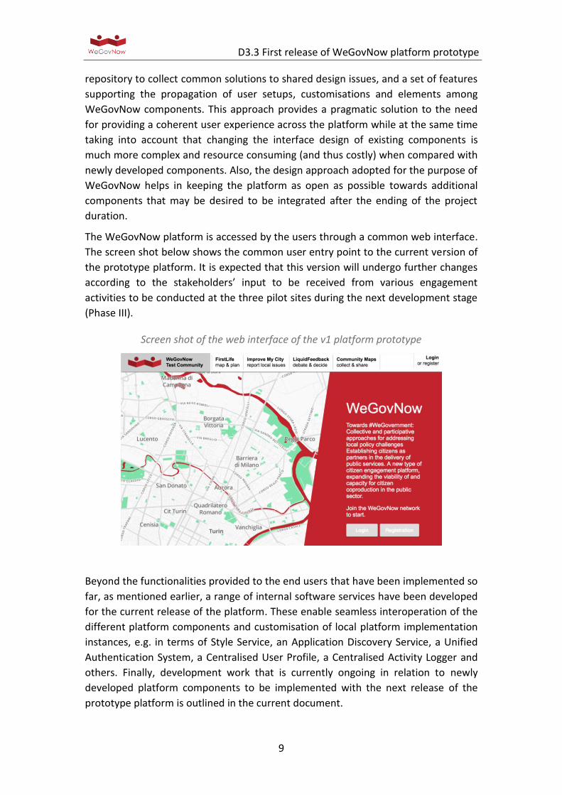
The WeGovNow platform is accessed by the users through a common web interface.
The screen shot below shows the common user entry point to the current version of
the prototype platform. It is expected that this version will undergo further changes
according to the stakeholders’ input to be received from various engagement
activities to be conducted at the three pilot sites during the next development stage
(Phase III).
Screen shot of the web interface of the v1 platform prototype
Beyond the functionalities provided to the end users that have been implemented so
far, as mentioned earlier, a range of internal software services have been developed
for the current release of the platform. These enable seamless interoperation of the
different platform components and customisation of local platform implementation
instances, e.g. in terms of Style Service, an Application Discovery Service, a Unified
Authentication System, a Centralised User Profile, a Centralised Activity Logger and
others. Finally, development work that is currently ongoing in relation to newly
developed platform components to be implemented with the next release of the
prototype platform is outlined in the current document.
D3.3 First release of WeGovNow platform prototype
10
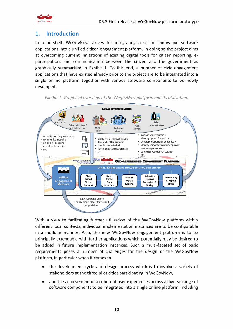
1. Introduction
In a nutshell, WeGovNow strives for integrating a set of innovative software
applications into a unified citizen engagement platform. In doing so the project aims
at overcoming current limitations of existing digital tools for citizen reporting, e-
participation, and communication between the citizen and the government as
graphically summarised in Exhibit 1. To this end, a number of civic engagement
applications that have existed already prior to the project are to be integrated into a
single online platform together with various software components to be newly
developed.
Exhibit 1: Graphical overview of the WegovNow platform and its utilisation.
With a view to facilitating further utilisation of the WeGovNow platform within
different local contexts, individual implementation instances are to be configurable
in a modular manner. Also, the new WeGovNow engagement platform is to be
principally extendable with further applications which potentially may be desired to
be added in future implementation instances. Such a multi-faceted set of basic
requirements poses a number of challenges for the design of the WeGovNow
platform, in particular when it comes to
the development cycle and design process which is to involve a variety of
stakeholders at the three pilot cities participating in WeGovNow,
and the achievement of a coherent user experiences across a diverse range of software components to be integrated into a single online platform, including
• capacity building measures• community mapping • on-site inspections• round table events• etc.
• swap resources/items• identify option for action• develop proposition collectively • identify minority/minority opinions
in a transparent way• co-create /co-deliver services• etc.
• raise / map / discuss issues• demand / offer support • look for like minded• communicate electronically• etc.
Offline
Engagement
Methods
GEO-REFERENCED ENGAGEMENT PLATFORM
Map-based Citizen
Network
Trusted Match Making
Collective Opinion
Formation & Voting
Digital Engagement Infrastructure Components
e.g. encourage online engagement, place formalised
propositions
LOCAL STAKEHOLDERS
Individual citizens
Third Sector
Citizen initiatives / self-help groups
Local Businesses
Public services
Public administration
Open Public Data
Interface
Community Mapping
Space
D3.3 First release of WeGovNow platform prototype
11
those that have existed prior WeGovNow already and those that are newly being developed within the project.
Against this background, a multi staged development approach has been adopted for
the purposes of WeGovNow. As graphically summarised in Exhibit 2, four main
phases can be discerned, starting with a thorough consolidation of the initial
platform architecture (D3.1) and the development of suitable testing protocols
(D3.2) to be utilised throughout the subsequent development phases.
This was followed by basic integration work (Phase II) mainly focussing on the
seamless interoperation of those software components that already existed prior to
WeGovnow, e.g. in terms of a unified user management solution. The current report
(D3.3) presents a paper based description of the 1st version prototype of the
WeGovNow platform as an outcome of this development phase.
Exhibit 2: WeGovNow platform development phases.
During the next development phase (Phase III), the current prototype version will be
further developed in an iterative manner within experimental settings, thereby
involving a diverse range of stakeholders in three cities participating in the project.
This will yield the final version of the fully tested platform which is then to be piloted
under everyday conditions with large numbers of users (Phase IV).
The following Chapter 2 of this report provides an overview of the integration work
achieved so far. This is followed by a description of the functionalities provided by
the current version of the WeGovNow platform prototype through the integration of
existing software components into the overall platform (Chapter 3). This is followed
by a description of the level of integration achieved so far when it comes to both,
components that have existed prior WeGovNow already and those components that
are specifically being developed for the purposes of WeGovNow (Chapter 4).
Moreover, core platform features implemented as internal software services with
the current prototype release are described (Chapter 5). Finally, ongoing
development work feeding into the next version of the platform prototype is
outlined (Chapter 6). To support a better understanding of the some of the
Platform architecture & testing protocol
development
Basic component integration
Iterative prototype refinement &
extension
Platform piloting under day to day
conditions
consolidated platform architecture (D3.1)
&testing protocols
(D3.2)
v1 platform prototype
(D3.3)
pilot platform
(D3.5)
v2 platform prototype
(D3.4)
Phase I Phase II Phase III Phase IV
D3.3 First release of WeGovNow platform prototype
12
information provided throughout the main body of this report, supportive material is
provided in the annex.
2. Overview of the integration work achieved so far
As mentioned above, the first release of the WeGovNow platform prototype (v1
prototype) largely results from the integration of existing software solutions into the
overall platform according to an architectural model developed during the start-up
phase of the project (D3.1), under the premise of building a seamless environment
specifically for:
1) user authentication
2) component navigation
The first prototype enables users to log in from any component and navigate
through the platform, keeping a user authentication session via “auto login”
functionality implemented by each component.
From the perspective of integrating the various software components, the first
prototype enables to use the individual components’ APIs by means of an UWUM
OAuth 2.0 token, generated by users’ authentication. The first prototype enables the
implementation of functionalities within the WeGovNow ecosystem, based on the
following patterns:
1. data integration (JSON/GeoJSON document exchange)
2. inclusion of dynamic html snippet
3. feature integration (HTML/CSS/JavaScript module integration)
4. integrated data based on the common logging system
For development purposes, the first platform prototype is provided in terms of two
technical “working” environments: one for development purposes and another one
for testing purposes. The development environment is meant to be constantly
updated with the alfa version of the software, it is specifically required to test the
communication between components and to perform integration tests. The testing
environment (sandbox) hosts the beta version of the software. The sandbox is meant
to enable usability and accessibility testing procedures (D3.2), to support
engagement activities, to extract content for producing communication material,
and to produce user guides. Both “working” environments - i.e. the development
and testing/presentation implementation instances - are accessible through the web:
- Development (https://dev.wegovnow.eu)
- Testing and presentations (https://sandbox.wegovnow.eu)
To support the involvement of stakeholders at the three pilot sites during the next
stage of platform development (Phase III) dedicated prototype implementation
instances are provided to each of the three trial sites:
D3.3 First release of WeGovNow platform prototype
13
- San Donà di Piave (https://sandona.wegovnow.eu)
- Southwark (https://southwark.wegovnow.eu)
- Torino (https://torino.wegovnow.eu)
From a development angle, the WeGovNow platform prototype as it currently stands
provides an environment of services (core features) required to run a WeGovNow
instance, including a set of stand-alone web components (WeGovNow components)
integrated into the overall platform. A local WeGovNow implementation instance
can be configured to use any combination of modular components, enabling cross-
component features according to the combination of active components.
Within the context of WeGovNow, the integration challenge concerns multiple
levels, i.e. integration of data, functionalities and interfaces. Each of the individual
software applications that have been integrated into the overall platform so far has
its inner coherence in terms of data, functionalities and interfaces. However, in
terms of WeGovNow platform components they must be harmonised with a view to
add value beyond their implementation as standalone solutions. The full
harmonisation of all three layers - data, functionalities and interfaces - will finally be
the result of the next stage of WeGovNow platform development work strand (Phase
III). During this phase, development work will be informed by ongoing use case
consolidation work (WP2) pursued at each of the three pilot cities, thereby involving
a variety of stake holders that are envisaged to utilise the WeGovNow platform for
their purposes (Exhibit 1).
From the perspective of the end users, the current version of the platform prototype
provides the following functionalities:
- Map-based social networking functionalities realised by means of integrating
FirstLife. A documentation is available at: o http://tutorials.firstlife.org/
(Italian)
- Citizen reporting functionalities realised by the integration of ImproveMyCity.
A documentation is available at:
o https://www.youtube.com/embed/CyHArXYCqnA?rel=0 (English)
o http://www.improve-my-city.com/features (English)
o https://wegovnow.improve-my-city.com/handbook (English)
- Opinion formation and voting functionalities realised by the integration of
LiquidFeedback. A documentation is available at:
o http://liquidfeedback.org/ (English)
o http://www.interaktive-demokratie.org/files/downloads/LF-
Information-Kit-EN.pdf (English)
o http://principles.liquidfeedback.org/ (English)
o http://dev.liquidfeedback.org/trac/lf/ (English)
D3.3 First release of WeGovNow platform prototype
14
- Community mapping functionalities realised by means of integrating
o Community Map. A documentation is available at:
http://help.communitymaps.org.uk/ (English, Italian)
o GeoKey. A documentation is available at: http://geokey.org.uk/docs/
(English)
When it comes to interface integration in particular, the approach adopted for the
purposes of WeGovNow can be characterised as a gradual convergence toward a
well-documented design framework (Material Design https://material.io/), a
repository to collect the solutions to shared design issues, and a set of features to
support the propagation of user setups, customisations and elements among
individual WeGovNow components.
Adopting a common design standard (Material Design) as a goal to be achieved by
the end of the prototype development phase and continuous collaboration in
addressing common issues can be seen as the operational approach towards
software integration adopted for the purposes of WeGovNow. This approach is a
pragmatic solution to the need of providing a coherent platform in a development
context within which changing the design of existing components is costly, time
consuming and not as straight forward as for new components. Approaching the
interface integration as a path and not as a requisite also enables the WeGovNow
platform to remain principally open towards developers and companies who may be
interested in contributing further platform components in the future, thereby
avoiding unreasonable demands such as to re-design existing software as mandatory
condition.
At the same time, WeGovNow provides many services to support the integration of
platform components, and the choice of Material Design was not at least made due
to the availability of extensive documentations, examples and frameworks based
material supporting to the development of material interfaces in the most popular
web languages and frameworks.
D3.3 First release of WeGovNow platform prototype
15
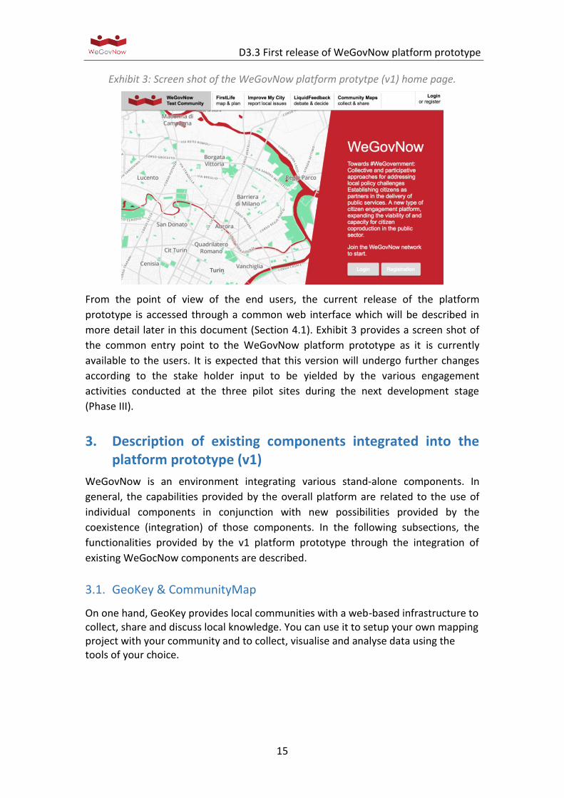
Exhibit 3: Screen shot of the WeGovNow platform protytpe (v1) home page.
From the point of view of the end users, the current release of the platform
prototype is accessed through a common web interface which will be described in
more detail later in this document (Section 4.1). Exhibit 3 provides a screen shot of
the common entry point to the WeGovNow platform prototype as it is currently
available to the users. It is expected that this version will undergo further changes
according to the stake holder input to be yielded by the various engagement
activities conducted at the three pilot sites during the next development stage
(Phase III).
3. Description of existing components integrated into the platform prototype (v1)
WeGovNow is an environment integrating various stand-alone components. In
general, the capabilities provided by the overall platform are related to the use of
individual components in conjunction with new possibilities provided by the
coexistence (integration) of those components. In the following subsections, the
functionalities provided by the v1 platform prototype through the integration of
existing WeGocNow components are described.
3.1. GeoKey & CommunityMap
On one hand, GeoKey provides local communities with a web-based infrastructure to collect, share and discuss local knowledge. You can use it to setup your own mapping project with your community and to collect, visualise and analyse data using the tools of your choice.
D3.3 First release of WeGovNow platform prototype
16
Key Features
Setup up your data structures: You decide what data your community should collect by setting up categories and attributes.
Decide who can access, contribute and moderate data: Use user groups and data groupings — a predefined subset of all data contributed to the project — to define, which users can access, contribute and moderate data.
Add photos, videos and audio files to your contributions: Enrich your contributions by uploading photos and videos to each of your contributions.
Discuss: Comments on each contribution allow you and your community to discuss observations you have made, offer suggestions and links to other web-based material.
Connect your app using our API: Use our public REST API to build and connect applications for data collection, analysis and visualisation.
On the other hand, we have the web-map based application, CommunityMaps. This
application allows users to collect new data, visualize the existing data, discuss and
attach media to the contributions added to the projects previously created on
GeoKey using the public REST API.
One real example could be that one municipality wants to do a survey to know
where the inaccessible wheelchair local businesses are in the neighbourhood. The
municipality will define the data structure on GeoKey (e.g. defining the name of
business and type of business, selection criteria to assess the level of access etc.).
Southwark will decide who can contribute to the project as well.
Once the municipality makes the project live, any citizen will be able to add contributions and comments to any of the contributions on the project. Indeed, users will be able to attach media files such as audio, video and pictures.
GeoKey has different extension which allow project administrators to export data. In this example, the municipality will be able to download the data in different formats (GeoJSON, KML or CSV), to upload data to existing projects, and additional functions which you can find on ExCiteS Group repository (https://github.com/ExCiteS/).
3.2. FirstLife
FirstLife is newest software among the existing component of WeGovNow, and at
current time is yet to be widely adopted outside pilots and projects. The maturity
level of FirstLife is therefore inferior to others and it is only currently being finalised
as service.
FirstLife addresses the need of a coordination/collaboration platform for urban
activities and urban services. One of the strong aspects of FirstLife is to provide a
working environment shared among the heterogeneous urban actors, such as
D3.3 First release of WeGovNow platform prototype
17
institutions, organisations, charities, privates, etc. Moreover, FirstLife supports the
self-organisation of citizens and informal groups.
Mapping, organization and documentation of distributed events
FirstLife supports a set of users’ actions on distributed entities, such as events.
Users can add events on the map, linking them through a set of tags allowing to
search for all the elements connected to a specific topic (for example: the name of a
festival used as tag provide the possibility to create automatically a tag-map) or
grouping all the events in an “initiative” that is a relation among entities. Different
users can add new events on the map and decide to link them to a specific initiative,
or contribute in describing and sharing real-time updates about planned, on-going or
past events by adding a post in the entity card.
Users can create groups and sub-groups to manage in a light way coordination
activities among the organizers and other people involved in the events (supporters,
public, places owners, etc.). News and posts can be shared within each group, but
keeping the information public for all the platform users.
Users can add stories to each event or group, sharing their experience about a
specific event of the initiative in general, building a live and collaborative report of
the events.
Users can easily retrieve all contents related to a specific initiative by selecting a
period of interest on the timeline in the main interface and using FirstLife as an
interactive archive of city activities.
Create groups to organize joint activities in multiple places
Citizen organizations operating in one or more neighbourhood of the city can create
groups to coordinate and document the activities related to a specific project, such
as managing a few urban gardens, with their schedules of gardening activities.
Each group can contain a list of places with their cards, events, news and stories.
Each member of the group can add new content to the group (events or news) and
visualize the map of the group.
General users, not members of the group, can explore the group content and choose
to follow the group and receive notification about updates and new-shared content.
3.3. ImproveMyCity
Direct citizen-government communication & collaboration
ImproveMyCity enables residents to directly report, to their public administration,
everyday local issues about their neighbourhood such as; discarded trash bins, faulty
D3.3 First release of WeGovNow platform prototype
18
streetlights, and broken tiles on sidewalks, illegal advertising boards, but also ideas
and suggestions.
The reported issues are automatically transmitted to the appropriate department in
public administration to schedule their settlement more quickly and more efficient
comparing to the tradition paperwork based procedures. Reporting is feasible
through a friendly web based frontend that adopts a map-based visualisation, which
makes reporting a user-friendly and intriguing process. The management and routing
of incoming issues is performed through a backend administration infrastructure
that serves as an integrated management system with easy to use interfaces.
Key features frontend
Accurately positioned issues: By offering a map to facilitate citizens in
determining the exact location of their issue with geocoding and reverse
geocoding support
Categorised on issue nature: By urging citizens to select one of the pre-
specified categories reflecting the municipality departments and its internal
organisation
Easily submit new issues: By asking citizens to provide only the information
necessary to locate and resolve the issue, such as title, description, location
and category
Photo enabled: By allowing to attach one or more images on the spot for
describing the issue, easily with drag ‘n drop
Commented and voted: By offering the mechanisms to post comments or
vote for issues that have been submitted by other citizens
Filtering and search: By allowing to see only your own issues, or issues of
specific categories or specific status or a combination of them
Key features backend (concerns the Municipality employees and administrators)
Browse effectively: Issues are presented on the city map, as an ordered list
but also in a single-issue page displaying the full set of submitted details. Only
assigned issues are visible according to the user group that each officer
belongs
Track pending issues: Issues are automatically routed not only to the
appropriate department but also to the inbox of the responsible officer.
Detailed rules defined who gets notification and on what action
Provide direct feedback: Provide written feedback to the citizens giving non-
standard explanations for each specific case with a very friendly user
interface that guides officers to take action
Distributed responsibilities: Assign one or more officers per category and/or
user group and split the administration effort across the municipality
departments
D3.3 First release of WeGovNow platform prototype
19
Monitor progress: Resolve issues and inform citizens by email automatically
or through a progress indication bar (Open - Acknowledged - Closed, etc.)
Tailored to each authority/Municipality: Fully customize the system in terms
of user rights, number and nature of categories, notification rules and
localization settings. The hierarchy of the Municipality can be projected to
the application no matter the complexity.
A typical example would be:
A citizen, on her way to work, realised that the pedestrian crossing lights next to the
primary school are not synchronised correctly and more over they do not let enough
time for children to cross the street safely. The citizen does not have time to go in
person to the municipal police to submit an official complain, and she is afraid that
this action will be very time consuming and very bureaucratic. Still she really needs
to inform the officials about the issue because it is not an obvious problem and
maybe no one else noticed that already. She realised the problem after many times
of observing the children and the lights in that specific crossroad. Using
ImproveMyCity to report the issue is very easy. She spots the road by typing the
address and she fine tune the marker by zooming and drag to the correct place on
map. She also uploads a photo of the pedestrian crossing and selects the Municipal
Police category from the available ones. She submits the issue and immediately
receives an informative email that her issue submitted successfully.
On the other hand, the Municipality employees who are set to get notifications
when a new issue is submitted to their department, are aware of the new post. They
read about it and unmoderated since it concerns a real problem and the status of the
issue is set to acknowledged. The issue is now publicly available for other citizens to
see thus promoting transparency. Moments later, the issue receives 15 upvotes and
2 comments by other citizens in the neighbourhood saying that they also are aware
of the problem but they didn’t know where to report about. It proved to be an issue
that concerned a lot of people but left unreported for months. All these votes,
eventually speed up the process of having the issue fixed in the next 2 days already.
The status of the issue has changed in every step so that the citizens are aware of
the progress. The problem is solved and anyone could see how fast the Municipality
responded.
3.4. LiquidFeedback
LiquidFeedback allows for opinion formation on a given issue with a discussion
(deliberation) phase before the actual voting.
Citizens can start initiatives (proposals) and seek support among their fellow citizens.
Other citizens can suggest improvements or start alternative initiatives. Considering
nobody has enough time and knowledge for every issue, votes can be dynamically
D3.3 First release of WeGovNow platform prototype
20
delegated by topic. Delegations are transitive and can be revoked at any time. Liquid
Democracy is sometimes referred to as »Delegated« or »Proxy Voting«.
LiquidFeedback doesn't rely on a request commission and doesn't need a moderator.
Instead, all participants gain equal rights in a scalable structured discussion process
where it is ensured that minorities gain a fair share of representation and that even
individuals may put up their proposals for discussion. The system is designed in such
way that noisy minorities won't harm other minorities in the discussion process.
Predefined rules and timings ensure that plans on decision processes are made
public in time. Decisions are made by recorded vote only, and all voting-relevant
data in LiquidFeedback is made available to all participants in both human– and
machine–readable form. This enables a transparent decision-making process and
ensures that participants can verify the voting procedure.
LiquidFeedback doesn't ask predefined questions but encourages participants to
suggest alternatives. A sophisticated voting system is facilitated to allow participants
to express their opinions without necessity of tactical considerations. Its
mathematical properties avoid vote–splitting and allow that similar proposals don't
harm each other.
A typical example would be:
A citizen (initiator 1) suggests to allow BBQ in a given park and creates a new
initiative in the dedicated subject area for this park. As there are no other initiatives
on this matter, a new issue is automatically created. Other citizens support the idea.
One citizen writes a suggestion and asks to consider the fire danger and to restrict
the BBQ use to suitable areas. Some citizens share the concern and support the
suggestion. Initiator 1 accepts the suggestions and uses the input map to mark areas
in the park he thinks may be suitable.
Another citizen (initiator 2) likes the general idea but comes up with an alternative
initiative. She suggests a picnic area with tables, benches and fixed fire places. She
suggests a specific location in the park and marks it on the map. The alternative soon
becomes as popular as the original initiative.
Another citizen suggests another location because that location would be closer to
existing public restrooms. However, initiator 2, does not like the idea and therefore
does not accept the suggestion. As a consequence, the citizen (now initiator 3) starts
another alternative initiative and marks the proposed location on the map.
Over the next weeks all initiatives in this issue undergo a process of improvements
by considering and eventually accepting suggestions. Citizens can support more than
one initiative.
Only a few days before the foreseen discussion phase ends, a citizen (initiator 4)
adds another alternative basically combining initiative 2 and 3 by suggesting picnic
areas in both places.

D3.3 First release of WeGovNow platform prototype
21
Finally, all initiatives with the necessary support, e.g. 10 percent of the people
interested in the issue, become voting options. The citizens can vote using a
preferential order, starting with their favorite initiative. This way citizens can agree
to a second choice without fearing this could harm their favorite. Likewise, citizens
are not encouraged to tactical voting, e.g. exclusively voting in favor of the second
choice just because they think their favorite has no chances.
LiquidFeedback’s preferential voting (Clone Proof Schwartz Sequential Dropping)
determines a collective preference.
D3.3 First release of WeGovNow platform prototype
22
4. Level of integration achieved in relation to existing and newly developed components
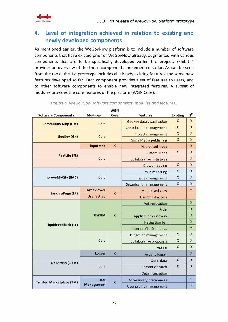
As mentioned earlier, the WeGovNow platform is to include a number of software
components that have existed prior of WeGovNow already, augmented with various
components that are to be specifically developed within the project. Exhibit 4
provides an overview of the those components implemented so far. As can be seen
from the table, the 1st prototype includes all already existing features and some new
features developed so far. Each component provides a set of features to users, and
to other software components to enable new integrated features. A subset of
modules provides the core features of the platform (WGN Core).
Exhibit 4. WeGovNow software components, modules and features..
Software Components Modules WGN Core Features Existing 1
st
Community Map (CM) Core GeoKey data visualisation X X
Contribution management X X
GeoKey (GK) Core Project management X X
SocialMedia publishing X X
FirstLife (FL)
InputMap X Map-based input X
Core
Custom Maps X X
Collaborative Initiatives X
Crowdmapping X X
ImproveMyCity (IMC) Core
Issue reporting X X
Issue management X X
Organisation management X X
LandingPage (LP) AreaViewer
X Map-based view
~
User's Area User's fast access
LiquidFeedback (LF)
UWUM X
Authentication X
Style X
Application discovery X
Navigation bar X
User profile & settings ~
Core
Delegation management X X
Collaborative proposals X X
Voting X X
OnToMap (OTM)
Logger X Activity logger X
Core
Open data X X
Semantic search X X
Data integration
Trusted Marketplace (TM) User
Management X
Accessibility preferences ~
User profile management ~
D3.3 First release of WeGovNow platform prototype
23
Core
Activity timeline
Reputation mechanism
Offer & Demands
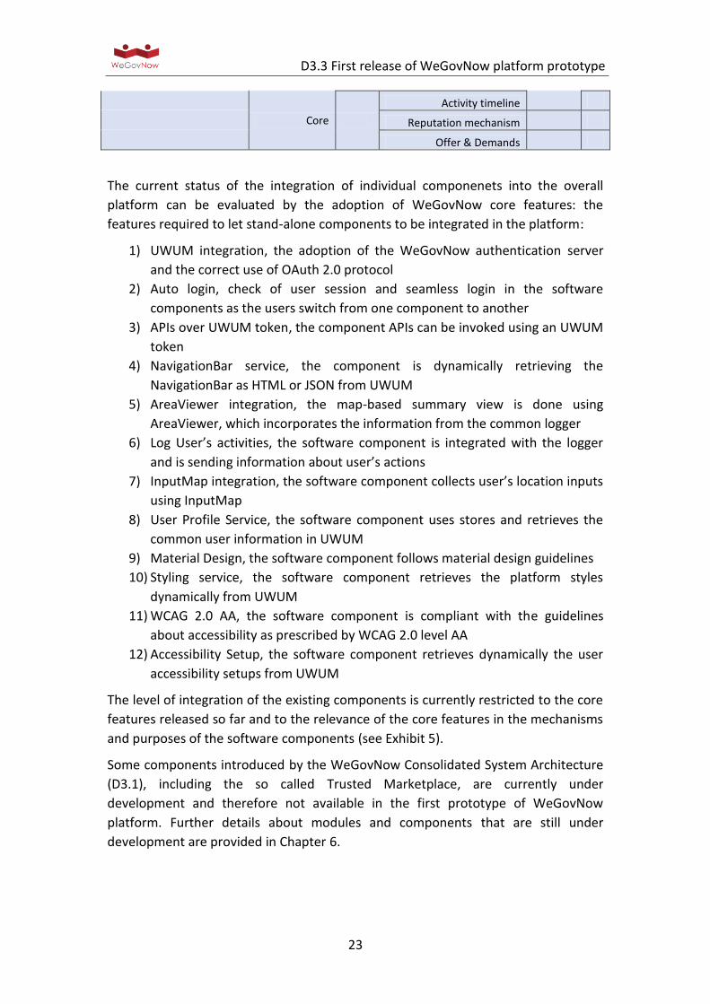
The current status of the integration of individual componenets into the overall
platform can be evaluated by the adoption of WeGovNow core features: the
features required to let stand-alone components to be integrated in the platform:
1) UWUM integration, the adoption of the WeGovNow authentication server
and the correct use of OAuth 2.0 protocol
2) Auto login, check of user session and seamless login in the software
components as the users switch from one component to another
3) APIs over UWUM token, the component APIs can be invoked using an UWUM
token
4) NavigationBar service, the component is dynamically retrieving the
NavigationBar as HTML or JSON from UWUM
5) AreaViewer integration, the map-based summary view is done using
AreaViewer, which incorporates the information from the common logger
6) Log User’s activities, the software component is integrated with the logger
and is sending information about user’s actions
7) InputMap integration, the software component collects user’s location inputs
using InputMap
8) User Profile Service, the software component uses stores and retrieves the
common user information in UWUM
9) Material Design, the software component follows material design guidelines
10) Styling service, the software component retrieves the platform styles
dynamically from UWUM
11) WCAG 2.0 AA, the software component is compliant with the guidelines
about accessibility as prescribed by WCAG 2.0 level AA
12) Accessibility Setup, the software component retrieves dynamically the user
accessibility setups from UWUM
The level of integration of the existing components is currently restricted to the core
features released so far and to the relevance of the core features in the mechanisms
and purposes of the software components (see Exhibit 5).
Some components introduced by the WeGovNow Consolidated System Architecture
(D3.1), including the so called Trusted Marketplace, are currently under
development and therefore not available in the first prototype of WeGovNow
platform. Further details about modules and components that are still under
development are provided in Chapter 6.
D3.3 First release of WeGovNow platform prototype
24
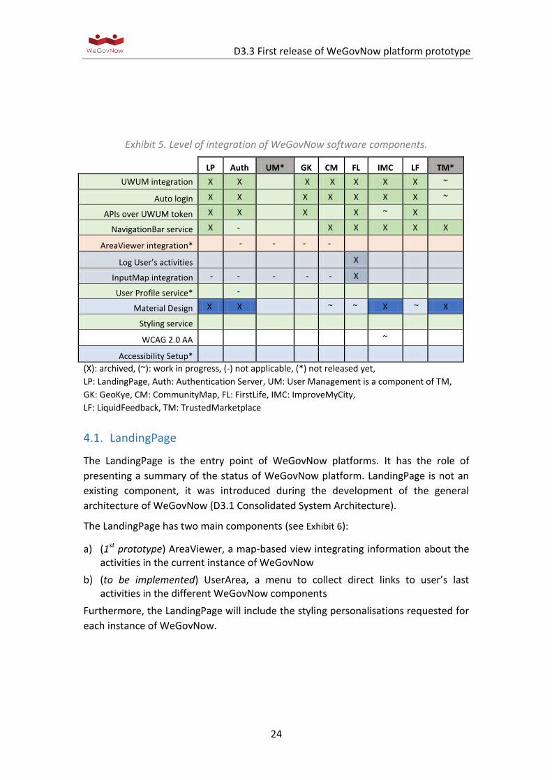
Exhibit 5. Level of integration of WeGovNow software components.
LP Auth UM* GK CM FL IMC LF TM*
UWUM integration X X X X X X X ~
Auto login X X X X X X X ~
APIs over UWUM token X X X X ~ X
NavigationBar service X - X X X X X
AreaViewer integration* - - - -
Log User’s activities X
InputMap integration - - - - - X
User Profile service* -
Material Design X X ~ ~ X ~ X
Styling service
WCAG 2.0 AA ~
Accessibility Setup*
(X): archived, (~): work in progress, (-) not applicable, (*) not released yet,
LP: LandingPage, Auth: Authentication Server, UM: User Management is a component of TM,
GK: GeoKye, CM: CommunityMap, FL: FirstLife, IMC: ImproveMyCity,
LF: LiquidFeedback, TM: TrustedMarketplace
4.1. LandingPage
The LandingPage is the entry point of WeGovNow platforms. It has the role of
presenting a summary of the status of WeGovNow platform. LandingPage is not an
existing component, it was introduced during the development of the general
architecture of WeGovNow (D3.1 Consolidated System Architecture).
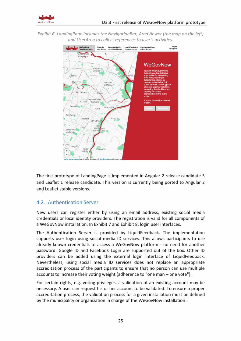
The LandingPage has two main components (see Exhibit 6):
a) (1st prototype) AreaViewer, a map-based view integrating information about the activities in the current instance of WeGovNow
b) (to be implemented) UserArea, a menu to collect direct links to user’s last activities in the different WeGovNow components
Furthermore, the LandingPage will include the styling personalisations requested for
each instance of WeGovNow.
D3.3 First release of WeGovNow platform prototype
25
Exhibit 6. LandingPage includes the NavigationBar, AreaViewer (the map on the left) and UserArea to collect references to user’s activities.
The first prototype of LandingPage is implemented in Angular 2 release candidate 5
and Leaflet 1 release candidate. This version is currently being ported to Angular 2
and Leaflet stable versions.
4.2. Authentication Server
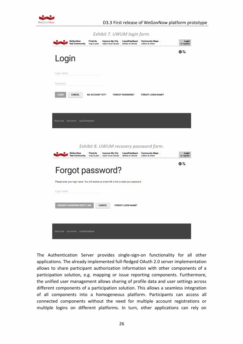
New users can register either by using an email address, existing social media credentials or local identity providers. The registration is valid for all components of a WeGovNow installation. In Exhibit 7 and Exhibit 8, login user interfaces.
The Authentication Server is provided by LiquidFeedback. The implementation supports user login using social media ID services. This allows participants to use already known credentials to access a WeGovNow platform - no need for another password. Google ID and Facebook Login are supported out of the box. Other ID providers can be added using the external login interface of LiquidFeedback. Nevertheless, using social media ID services does not replace an appropriate accreditation process of the participants to ensure that no person can use multiple accounts to increase their voting weight (adherence to "one man – one vote").
For certain rights, e.g. voting privileges, a validation of an existing account may be necessary. A user can request his or her account to be validated. To ensure a proper accreditation process, the validation process for a given installation must be defined by the municipality or organization in charge of the WeGovNow installation.
D3.3 First release of WeGovNow platform prototype
26
Exhibit 7. UWUM login form.
Exhibit 8. UWUM recovery password form.
The Authentication Server provides single-sign-on functionality for all other
applications. The already implemented full-fledged OAuth 2.0 server implementation
allows to share participant authorization information with other components of a
participation solution, e.g. mapping or issue reporting components. Furthermore,
the unified user management allows sharing of profile data and user settings across
different components of a participation solution. This allows a seamless integration
of all components into a homogeneous platform. Participants can access all
connected components without the need for multiple account registrations or
multiple logins on different platforms. In turn, other applications can rely on
D3.3 First release of WeGovNow platform prototype
27
LiquidFeedback as an identity provider, including a check whether an internet user
has voting privileges in a given setup.
A full description of the implementation can be found in LiquidFeedsback's Work
report on Unified WeGovNow User Management (UWUM) development.
4.3. GeoKey and Community Maps
GeoKey provides a database-driven backend storage, together with a custom API
that allows two main tasks namely interaction with data (data creation, editing,
deleting) and the creation of projects which group data together. The latter is
accessed via a web-based project management interface. In addition to this
functionality, an API is also provided for user management, which is again enabled
via a web-based frontend. The GeoKey architecture allows the data store to be
accessed by any frontend application from the WeGovNow suite (web or mobile
based) which can be customised making use of the provided APIs.
A flexible and stylish participatory mapping frontend, Community Maps can visualise
data, compare information, and encourage conversation about the places which
matter. Designed using the latest web development technologies, Community Maps
offers a fast, reliable and intuitive interface. The display is clear, professional, and
engaging for all screen types.
The Community Maps tools have been developed to make use of the GeoKey public
REST API and separation between GeoKey and Community Maps allows to have one
user interface for project management (more technical) and another for data
collection/visualisation (intuitive and easy to use). This method hides complexity of
the technology behind the minimalistic and modern approach for end-user
interaction. All information within Community Maps is stored on GeoKey, where the
API enables storage and retrieval of e data via secure SSL connection.
GeoKey is a web based platform for participatory mapping. GeoKey is the connecting
point between data collection on the one hand and data utilisation through the
analysis and visualization on the other hand.
GeoKey
GeoKey is a web based platform for participatory mapping. GeoKey is the connecting
point between data collection on the one hand and data utilisation through the
analysis and visualization on the other hand.
GeoKey allows project administrators (in WGN this relates primarily to
municipalities) to generate their own projects and define the data on different
categories. The type of data will differ depending the category and the type of data
(fields) should be predefined by the admins. The existing type of fields in GeoKey are:
D3.3 First release of WeGovNow platform prototype
28
Text Numeric Date / Date & time / Time Selectbox Multiple select box
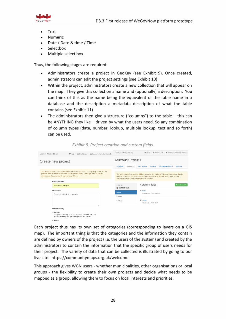
Thus, the following stages are required:
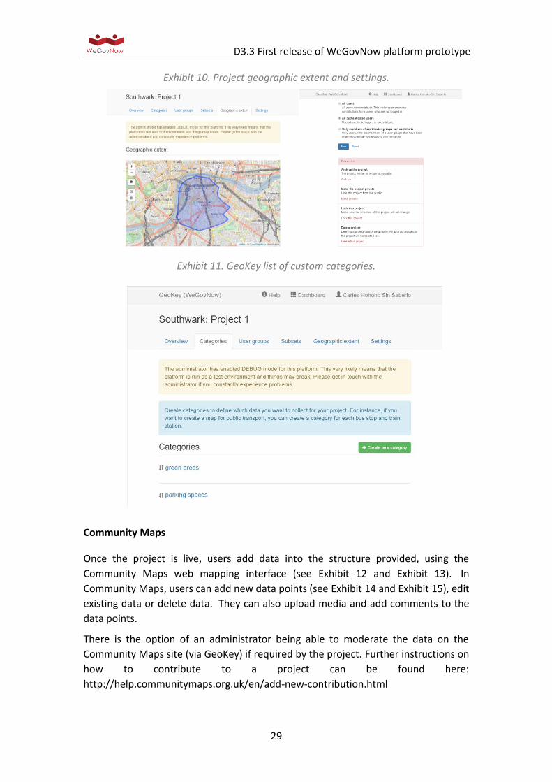
Administrators create a project in GeoKey (see Exhibit 9). Once created,
administrators can edit the project settings (see Exhibit 10)
Within the project, administrators create a new collection that will appear on
the map. They give this collection a name and (optionally) a description. You
can think of this as the name being the equivalent of the table name in a
database and the description a metadata description of what the table
contains (see Exhibit 11)
The administrators then give a structure (“columns”) to the table – this can
be ANYTHING they like – driven by what the users need. So any combination
of column types (date, number, lookup, multiple lookup, text and so forth)
can be used.
Exhibit 9. Project creation and custom fields.
Each project thus has its own set of categories (corresponding to layers on a GIS
map). The important thing is that the categories and the information they contain
are defined by owners of the project (i.e. the users of the system) and created by the
administrators to contain the information that the specific group of users needs for
their project. The variety of data that can be collected is illustrated by going to our
live site: https://communitymaps.org.uk/welcome
This approach gives WGN users - whether municipalities, other organisations or local
groups - the flexibility to create their own projects and decide what needs to be
mapped as a group, allowing them to focus on local interests and priorities.
D3.3 First release of WeGovNow platform prototype
29
Exhibit 10. Project geographic extent and settings.
Exhibit 11. GeoKey list of custom categories.
Community Maps
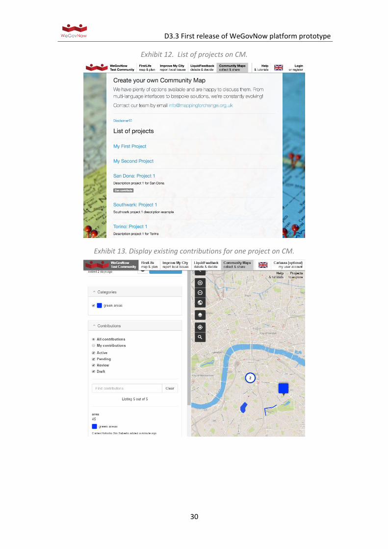
Once the project is live, users add data into the structure provided, using the
Community Maps web mapping interface (see Exhibit 12 and Exhibit 13). In
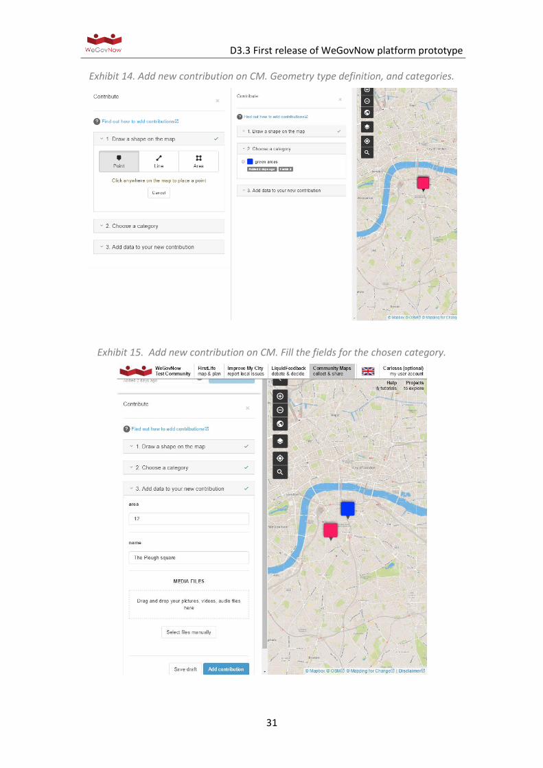
Community Maps, users can add new data points (see Exhibit 14 and Exhibit 15), edit
existing data or delete data. They can also upload media and add comments to the
data points.
There is the option of an administrator being able to moderate the data on the
Community Maps site (via GeoKey) if required by the project. Further instructions on
how to contribute to a project can be found here:
http://help.communitymaps.org.uk/en/add-new-contribution.html
D3.3 First release of WeGovNow platform prototype
30
Exhibit 12. List of projects on CM.
Exhibit 13. Display existing contributions for one project on CM.
D3.3 First release of WeGovNow platform prototype
31
Exhibit 14. Add new contribution on CM. Geometry type definition, and categories.
Exhibit 15. Add new contribution on CM. Fill the fields for the chosen category.

D3.3 First release of WeGovNow platform prototype
32
4.4. FirstLife
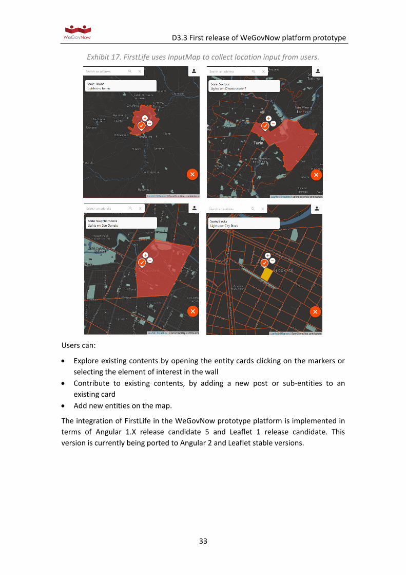
FirstLife is a map-based solution (see Exhibit 16) enabling users to interact with five
types of entities: places, events, news, stories, and groups.
Each entity is an aggregation of geo-referenced contents related to a specific
geographical unit or area (see Exhibit 17), at multiple scale: building, city block,
neighbourhood, district, city, etc.
Exhibit 16. FirstLife map-based view: pie charts representing clusters of markers.
D3.3 First release of WeGovNow platform prototype
33
Exhibit 17. FirstLife uses InputMap to collect location input from users.
Users can:
Explore existing contents by opening the entity cards clicking on the markers or
selecting the element of interest in the wall
Contribute to existing contents, by adding a new post or sub-entities to an
existing card
Add new entities on the map.
The integration of FirstLife in the WeGovNow prototype platform is implemented in
terms of Angular 1.X release candidate 5 and Leaflet 1 release candidate. This
version is currently being ported to Angular 2 and Leaflet stable versions.
D3.3 First release of WeGovNow platform prototype
34
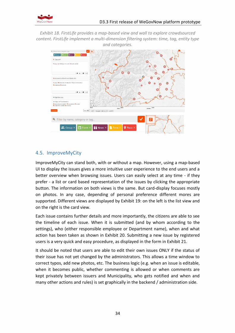
Exhibit 18. FirstLife provides a map-based view and wall to explore crowdsourced content. FirstLife implement a multi-dimension filtering system: time, tag, entity type
and categories.
4.5. ImproveMyCity
ImproveMyCity can stand both, with or without a map. However, using a map-based
UI to display the issues gives a more intuitive user experience to the end users and a
better overview when browsing issues. Users can easily select at any time - if they
prefer - a list or card based representation of the issues by clicking the appropriate
button. The information on both views is the same. But card-display focuses mostly
on photos. In any case, depending of personal preference different mores are
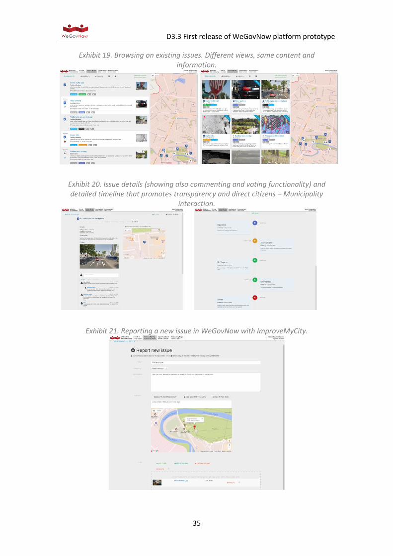
supported. Different views are displayed by Exhibit 19: on the left is the list view and
on the right is the card view.
Each issue contains further details and more importantly, the citizens are able to see
the timeline of each issue. When it is submitted (and by whom according to the
settings), who (either responsible employee or Department name), when and what
action has been taken as shown in Exhibit 20. Submitting a new issue by registered
users is a very quick and easy procedure, as displayed in the form in Exhibit 21.
It should be noted that users are able to edit their own issues ONLY if the status of
their issue has not yet changed by the administrators. This allows a time window to
correct typos, add new photos, etc. The business logic (e.g. when an issue is editable,
when it becomes public, whether commenting is allowed or when comments are
kept privately between issuers and Municipality, who gets notified and when and
many other actions and rules) is set graphically in the backend / administration side.
D3.3 First release of WeGovNow platform prototype
35
Exhibit 19. Browsing on existing issues. Different views, same content and information.
Exhibit 20. Issue details (showing also commenting and voting functionality) and detailed timeline that promotes transparency and direct citizens – Municipality
interaction.
Exhibit 21. Reporting a new issue in WeGovNow with ImproveMyCity.
D3.3 First release of WeGovNow platform prototype
36
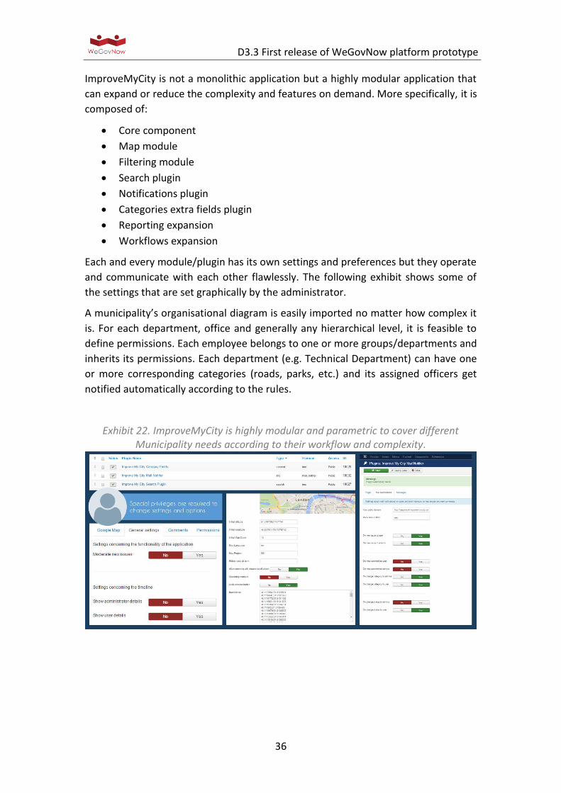
ImproveMyCity is not a monolithic application but a highly modular application that
can expand or reduce the complexity and features on demand. More specifically, it is
composed of:
Core component
Map module
Filtering module
Search plugin
Notifications plugin
Categories extra fields plugin
Reporting expansion
Workflows expansion
Each and every module/plugin has its own settings and preferences but they operate
and communicate with each other flawlessly. The following exhibit shows some of
the settings that are set graphically by the administrator.
A municipality’s organisational diagram is easily imported no matter how complex it
is. For each department, office and generally any hierarchical level, it is feasible to
define permissions. Each employee belongs to one or more groups/departments and
inherits its permissions. Each department (e.g. Technical Department) can have one
or more corresponding categories (roads, parks, etc.) and its assigned officers get
notified automatically according to the rules.
Exhibit 22. ImproveMyCity is highly modular and parametric to cover different Municipality needs according to their workflow and complexity.
D3.3 First release of WeGovNow platform prototype
37
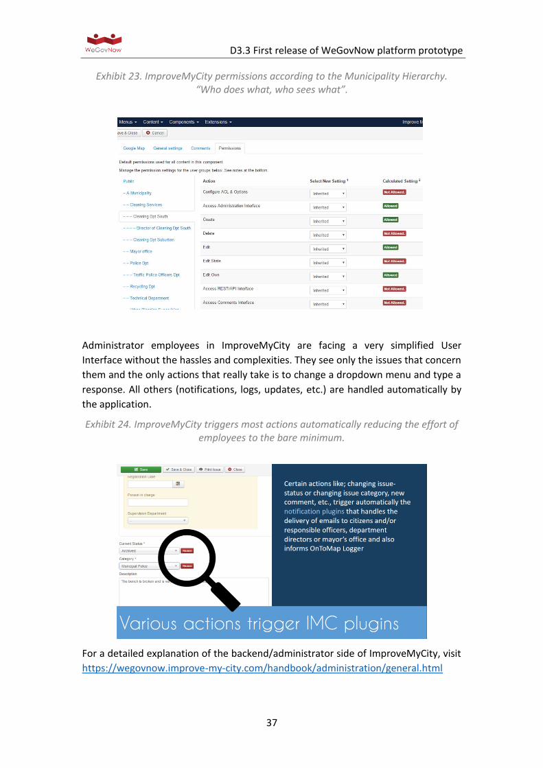
Exhibit 23. ImproveMyCity permissions according to the Municipality Hierarchy. “Who does what, who sees what”.
Administrator employees in ImproveMyCity are facing a very simplified User
Interface without the hassles and complexities. They see only the issues that concern
them and the only actions that really take is to change a dropdown menu and type a
response. All others (notifications, logs, updates, etc.) are handled automatically by
the application.
Exhibit 24. ImproveMyCity triggers most actions automatically reducing the effort of employees to the bare minimum.
For a detailed explanation of the backend/administrator side of ImproveMyCity, visit
https://wegovnow.improve-my-city.com/handbook/administration/general.html
D3.3 First release of WeGovNow platform prototype
38
4.6. LiquidFeedback
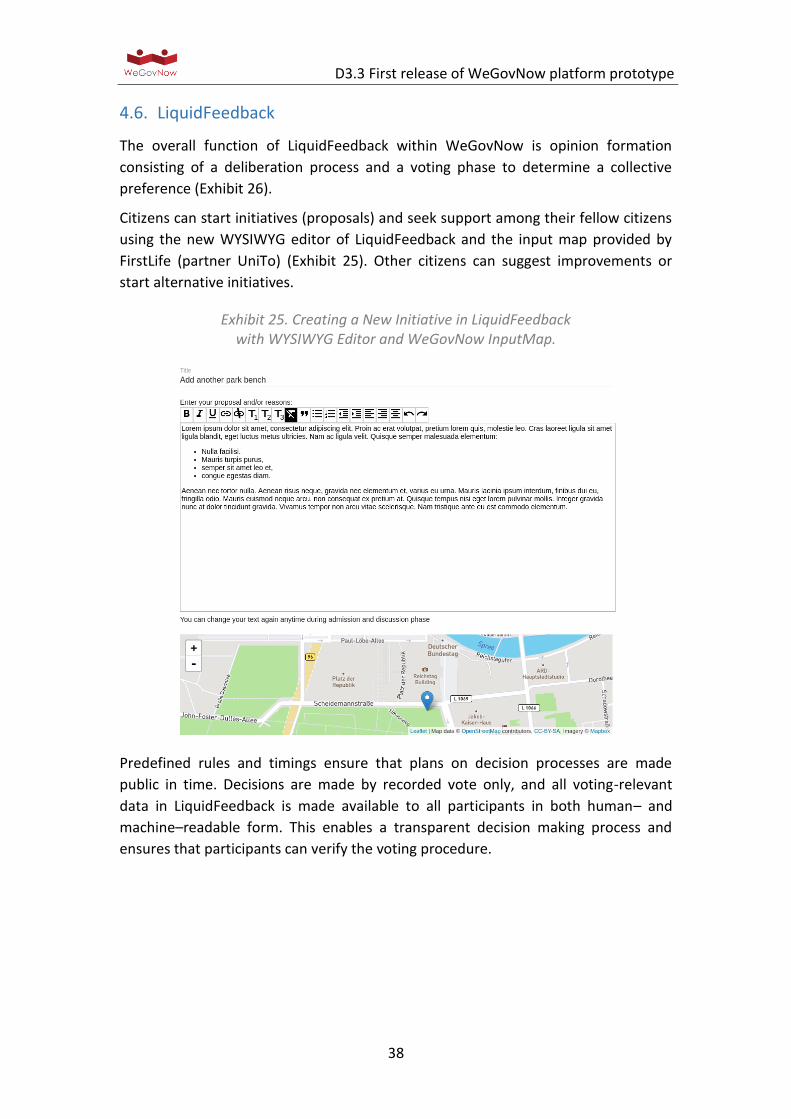
The overall function of LiquidFeedback within WeGovNow is opinion formation
consisting of a deliberation process and a voting phase to determine a collective
preference (Exhibit 26).
Citizens can start initiatives (proposals) and seek support among their fellow citizens
using the new WYSIWYG editor of LiquidFeedback and the input map provided by
FirstLife (partner UniTo) (Exhibit 25). Other citizens can suggest improvements or
start alternative initiatives.
Exhibit 25. Creating a New Initiative in LiquidFeedback with WYSIWYG Editor and WeGovNow InputMap.
Predefined rules and timings ensure that plans on decision processes are made
public in time. Decisions are made by recorded vote only, and all voting-relevant
data in LiquidFeedback is made available to all participants in both human– and
machine–readable form. This enables a transparent decision making process and
ensures that participants can verify the voting procedure.

D3.3 First release of WeGovNow platform prototype
39
Exhibit 26. The LiquidFeedback proposition development process.
In the context of WeGovNow, LiquidFeedback already added geospatial functionality
and published a core update as a prerequisite for the integration (see “Work report
on pgLatLon in Appendix 6.5, an alternative to PostGIS”and “Second work report on
extending the LiquidFeedback Core” in the appendix). The adoption of material
design is in progress.

D3.3 First release of WeGovNow platform prototype
40
5. Description of platform services
The core features of WeGovNow are meant to support the integration between
components. A set of core features is provided by an extension of stand-alone
components, while other core features required the definition of new modules. In
this regard, as indicated in Exhibit 4 and Exhibit 5, the first prototype of WeGovNow
does not include some new core features which are currently being developed.
The WeGovNow core thus provides features essential for realising the seamless
integration of individual WeGovNow components:
Unified Authentication System: it provides Functionalities concerning user registration, also using mainstream social networks accounts, and single sign-on.
Application Discovery Service: it is an API service providing the list and details of currently available components in a WeGovNow instance.
Style Service: it is an API service providing WeGovNow style sheets dynamically to the components, it is used to retrieve the instance personalisation such as colours, fonts, etc.
NavigationBar: it is an API service providing the description or the HTML source of WeGovNow navigation bar, including the button tabs to the current available components and the reference to the user profile.
Centralised User Profile: it provides a user profile data store accessible to all registered WeGovNow components to store, retrieve and share user profile information, it consents to keep user information updated across the platform.
Accessibility Settings: it is a wizard to collect and edit cross-platform user’s profile setups about accessibility (see section 6.2).
Centralised Activity Logger: it provides centralised data logging within the WeGovNow platform and data integration aimed at integrating the knowledge about users and about geographical data shared in the platform.
InputMap: it is an embeddable web map to collect spatial input (point based references) and references to existing entities in OntoMap.
AreaViewer: it is an embeddable web map to visualise summary information extracted from OntoMap (see section 6.3).
Linked Open Data and Crowdsourced Data endpoint: it is a semantic endpoint to retrieve the linked open data generated from the open data of the municipalities and the user activities within a WeGovNow instance.
As mentioned earlier, the core features are provided by existing and new
components specifically developed for WeGovNow.

D3.3 First release of WeGovNow platform prototype
41
Exhibit 27: WeGovNow core features provide the environment to integrate modular components accordingly to the specific needs of each WeGovNow instance.
Core features are used by modular components (see Exhibit 27) to:
Establish connections with other WeGovNow components
Provide cross-component features
Unify the appearance to the rest of a WeGovNow instance
Synchronise components
As any other modular component, core features themselves are optional as far as
their non-essential functionalities are concerned: if a core feature is not fully enabled
in a specific instance of WeGovNow, only its critical functionalities will be available.
In the following subsections, the WeGovNow core is described in more detail.
Authentication Server
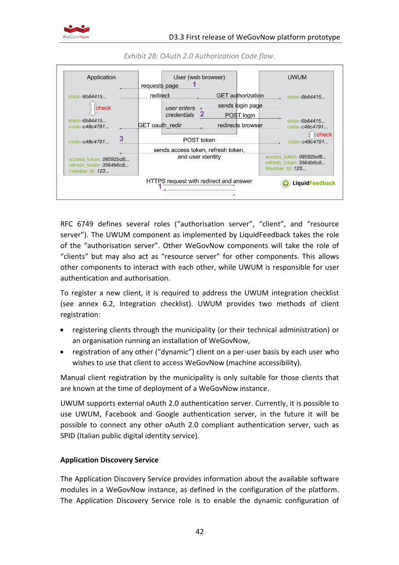
For reasons of interoperability and security, WeGovNow aims to create an
implementation that is fully compliant with the OAuth 2.0 Authorization Framework
as described in RFC 6749, but extended in such way that it allows for secure user
authentication following the OAuth 2.0 Authorization Code flow (see Exhibit 28).
Special security considerations were taken into account, for instance client identity
verification (through X.509 certificates) to repel authorisation code substitution
attacks. For further security considerations refer to Consolidated System
Architecture D3.1, section 2 and section 5.
D3.3 First release of WeGovNow platform prototype
42
Exhibit 28: OAuth 2.0 Authorization Code flow.
RFC 6749 defines several roles (“authorisation server”, “client”, and “resource
server”). The UWUM component as implemented by LiquidFeedback takes the role
of the “authorisation server”. Other WeGovNow components will take the role of
“clients” but may also act as “resource server” for other components. This allows
other components to interact with each other, while UWUM is responsible for user
authentication and authorisation.
To register a new client, it is required to address the UWUM integration checklist
(see annex 6.2, Integration checklist). UWUM provides two methods of client
registration:
registering clients through the municipality (or their technical administration) or
an organisation running an installation of WeGovNow,
registration of any other (“dynamic”) client on a per-user basis by each user who
wishes to use that client to access WeGovNow (machine accessibility).
Manual client registration by the municipality is only suitable for those clients that
are known at the time of deployment of a WeGovNow instance.
UWUM supports external oAuth 2.0 authentication server. Currently, it is possible to
use UWUM, Facebook and Google authentication server, in the future it will be
possible to connect any other oAuth 2.0 compliant authentication server, such as
SPID (Italian public digital identity service).
Application Discovery Service
The Application Discovery Service provides information about the available software
modules in a WeGovNow instance, as defined in the configuration of the platform.
The Application Discovery Service role is to enable the dynamic configuration of
D3.3 First release of WeGovNow platform prototype
43
active WeGovNow software components: to enable cross-components features
accordingly to the availability of other services, to provide navigation active
components can “discovery” other enabled components:
1) To enable of the dynamic configuration of WeGovNow software components,
2) To provide dynamic
New components can be included in a WGN instance and in WGN environment in
general following the Integration Checklist (see Annex 6.6).
The Application Discovery Service is available via a REST API endpoint for
authenticated clients. For technical details and future development of the
Application Discovery Service see Annex 2 to D3.1 WeGovNow Consolidated
Architecture,.
Style Service
An instance of WeGovNow includes style personalisation, for instance colours of a
municipality, fonts, icons, etc. The style service was introduced as part of UWUM
(Unified WeGovNow User Management) specifically to provide the style
personalisation of the current instance of WeGovNow.
The Style Service is ready but yet to be usable. The endpoint will be effectively
released as soon there will be developed a “css stylesheet” for WeGovNow including
fonts, colours, and all custom setups available in the platform configuration.
For technical details and further development of the Style Service see Annex 2 to
D3.1 WeGovNow Consolidated System Architecture.
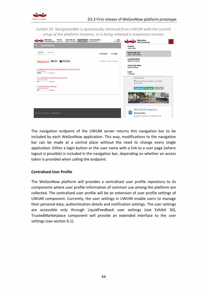
NavigationBar
To integrate all WeGovNow applications in such way that they look and feel like a
single application, all WeGovNow applications share a common WeGovNow
navigation bar (see Exhibit 29).
D3.3 First release of WeGovNow platform prototype
44
Exhibit 29. NavigationBar is dynamically retrieved from UWUM with the current setup of the platform instance. In is being released a responsive version.
The navigation endpoint of the UWUM server returns this navigation bar to be
included by each WeGovNow application. This way, modifications to the navigation
bar can be made at a central place without the need to change every single
application. Either a login button or the user name with a link to a user page (where
logout is possible) is included in the navigation bar, depending on whether an access
token is provided when calling the endpoint.
Centralised User Profile
The WeGovNow platform will provides a centralised user profile repository to its
components where user profile information of common use among the platform are
collected. The centralised user profile will be an extension of user profile settings of
UWUM component. Currently, the user settings in UWUM enable users to manage
their personal data, authentication details and notification settings. The user settings
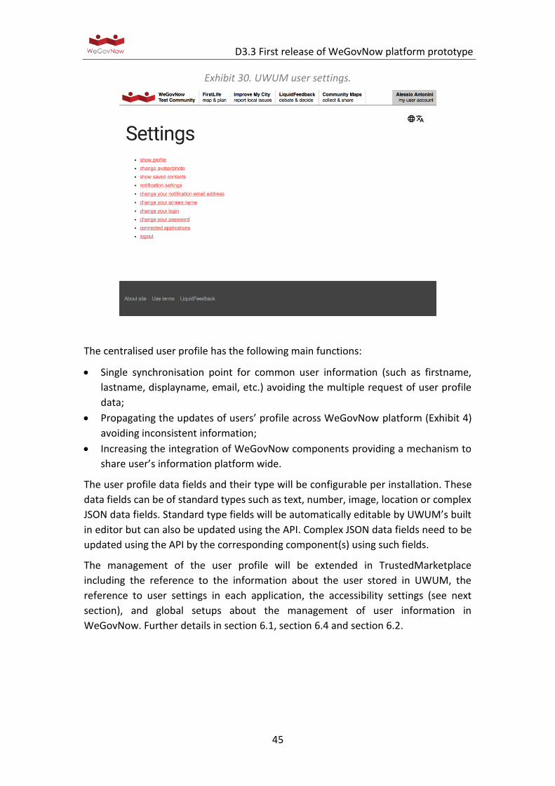
are accessible only through LiquidFeedback user settings (see Exhibit 30),
TrustedMarketplace component will provide an extended interface to the user
settings (see section 6.1).
D3.3 First release of WeGovNow platform prototype
45
Exhibit 30. UWUM user settings.
The centralised user profile has the following main functions:
Single synchronisation point for common user information (such as firstname,
lastname, displayname, email, etc.) avoiding the multiple request of user profile
data;
Propagating the updates of users’ profile across WeGovNow platform (Exhibit 4)
avoiding inconsistent information;
Increasing the integration of WeGovNow components providing a mechanism to
share user’s information platform wide.
The user profile data fields and their type will be configurable per installation. These
data fields can be of standard types such as text, number, image, location or complex
JSON data fields. Standard type fields will be automatically editable by UWUM’s built
in editor but can also be updated using the API. Complex JSON data fields need to be
updated using the API by the corresponding component(s) using such fields.
The management of the user profile will be extended in TrustedMarketplace
including the reference to the information about the user stored in UWUM, the
reference to user settings in each application, the accessibility settings (see next
section), and global setups about the management of user information in
WeGovNow. Further details in section 6.1, section 6.4 and section 6.2.
D3.3 First release of WeGovNow platform prototype
46
Linked Open Data and Crowdsourced endpoint
The OnToMap endpoint supports data integration within the WeGovNow platform.
The idea is that of having a single point of access to the geographical information
available in an instance of the platform, in a unified format and representation
language that enables the applications to retrieve and present shared data
regardless of their origin. Specifically:
1. OnToMap supports the integration of heterogeneous Open Data sources,
which are stored into the platform in a Linked Data format supporting the
semantic exploration of information (see below). Up to now, we have
acquired a portion of the Open Data from Torino and San Dona’ Di Piave
cities. In the next future, the Open Data from Southwark will be added.
Moreover, we are working at the integration of data from OpenStreetMap1,
in order to complement the data provided by the cities (e.g., in the cases in
which the Open Data is partial).
2. OnToMap supports the integration of data shared within the platform by the
WeGovNow applications, which can publish the users’ activities concerning
the creation, revision, etc., of data items through the OnToMap Logger. As
this type of information is based on the observation of events concerning
user activities, it is stored in a log as a set of events mapped to the common
terminology provided by OnToMap. This aspect is described in the section
about the OnToMap Logger.
The integration of heterogeneous data and their representation in a common format
is based on a semantic knowledge representation layer that reconciles data
representational and conceptual heterogeneity.
Exhibit 31. OnToMap architecture.
The OnToMap Ontology (see Exhibit 31) is a knowledge representation layer that
makes it possible to:
1 https://www.openstreetmap.org
D3.3 First release of WeGovNow platform prototype
47
Integrate heterogeneous Open Data and manage it as Linked Data. As reported in
http://linkeddata.org/, “Linked Data” is about using the Web to connect related
data that wasn't previously linked, or using the Web to lower the barriers to
linking data currently linked using other methods."
Provide a dictionary, shared in the platform, for mapping the concepts used in
the domain conceptualizations adopted by the WeGovNow applications to a
unified terminology for cross-application data sharing.
Describe semantic relations among information items to express spatial relations,
different levels of abstraction in the description of entities and thematic
relations. This approach enables a semantic and geospatial exploration of the
information space.
The OnToMap Ontology is defined using the OWL Web Ontology Language
(https://www.w3.org/OWL/).
The latest version of the OnToMap Ontology can be downloaded in OWL format at
the following URL: http://ontomap.eu/ontology/. The ontology includes about 100
concepts.
The following Exhibit 32 shows a portion of the current version of the OnToMap
ontology, focusing on concept “SchemaThing”, the root of the taxonomy concerning
geographical information.
“SchemaThing” specifies the main data structure for geographical information items.
It is related to concept “Revision”, in order to comply with the possibility of having
multiple versions of data, modified at different times by different users, and to
concept “Provenance” in order to support the retrieval of the provenance of the
current version of data. In turn, each revision of a geographical data item is related
to its own provenance, so that the revision history of data can be reconstructed.
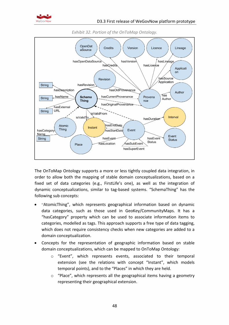
D3.3 First release of WeGovNow platform prototype
48
Exhibit 32. Portion of the OnToMap Ontology.
The OnToMap Ontology supports a more or less tightly coupled data integration, in
order to allow both the mapping of stable domain conceptualizations, based on a
fixed set of data categories (e.g., FirstLife’s one), as well as the integration of
dynamic conceptualizations, similar to tag-based systems. “SchemaThing” has the
following sub concepts:
“AtomicThing”, which represents geographical information based on dynamic
data categories, such as those used in GeoKey/CommunityMaps. It has a
“hasCategory” property which can be used to associate information items to
categories, modelled as tags. This approach supports a free type of data tagging,
which does not require consistency checks when new categories are added to a
domain conceptualization.
Concepts for the representation of geographic information based on stable
domain conceptualizations, which can be mapped to OnToMap Ontology:
o “Event”, which represents events, associated to their temporal
extension (see the relations with concept “Instant”, which models
temporal points), and to the “Places” in which they are held.
o “Place”, which represents all the geographical items having a geometry
representing their geographical extension.
D3.3 First release of WeGovNow platform prototype
49
Regarding this work, POLITO has collected, analysed and prepared for acquisition in
OnToMap the Open Data provided by the cities of Torino and San Dona’ di Piave, and
is doing the same work with the Open Data from Southwark. UNITO has carried out
the design and development of the Software (OWL ontology, OnToMap component).
Representation and storage of Open Data
The Open Data integrated in OnToMap is mapped to the ontology concepts and it is
represented as Linked Data, as RDF (Resource Description Framework2) triples. This
makes it possible to exploit standard tools for browsing the ontology and for
retrieving geographical information items.
As shown in Exhibit 31, OnToMap stores Linked Data in the Open Data Store: this is a
triple store, i.e., a specialized tool for managing and querying RDF datasets. The
current implementation of OnToMap exploits the Parliament triple store3, which
supports GeoSPARQL queries4.
OnToMap exploits the Apache Jena ontology API5 to perform GeoSPARQL queries on
ontology concepts. The result of a query is a set of RDF triples representing
geographical information items. This set of triples is translated to an external
GeoJSON format to make data directly usable by WeGovNow applications for map-
based presentation.
The mappings between the data categories defined in the Open Data Sources and
the ontology concepts are aimed at translating external data items to sets of RDF
triples to be loaded in OnToMap Open Data Store. As Open Data sources typically
use standard data representations, open source mapping tools can be found for
doing this work without defining ad-hoc software. For instance, for mapping shape
files to RDF data we use GeoTriples (https://github.com/LinkedEOData/GeoTriples)
Data retrieval API
The interaction between OnToMap and the other WeGovNow applications,
regarding data retrieval and semantic data representation, is managed through the
OnToMap Logger API specified at https://ontomap.eu/, which returns results as a
JSON object.
The API can be used to navigate the common data structure defined by the
OnToMap Ontology and to retrieve the Open Data provided by the OnToMap Open
Data Store, as well as the data crowdsourced by WeGovNow applications, in the
unified terminology and format provided by the OnToMap Ontology. Specifically:
2 https://www.w3.org/RDF/
3 http://parliament.semwebcentral.org/
4 http://www.opengeospatial.org/standards/geosparql
5 https://jena.apache.org/documentation/ontology/
D3.3 First release of WeGovNow platform prototype
50
The API supports the exploration of the concepts and relations stored in the
OnToMap Ontology. It makes it possible to retrieve the root concept of the
ontology, the list of concepts, the concepts related to a specific concept C, and so
forth.
The API can also be used to retrieve information about the instances of a concept
C, which can be expressed either in the terminology of the WeGovNow
application (in which case OnToMap translates C to the corresponding concept of
the OnToMap Ontology), or directly in the OnToMap Ontology format.
Depending on the filters used in the query, the retrieved instances can belong to
the Open Data and/or to the data crowdsourced by the WeGovNow applications.
The API supports filtering instances by geographical area and/or temporal
validity, and/or data source (e.g., Open Data belonging to a certain source,
crowdsourced data). The geographical information items returned by the API are,
by default, the most recent versions of the data available to OnToMap, and they
are represented as GeoJSON “Features”6.
The data retrieval API is fully developed. Currently, we are carrying out experiments
with a subset of the WeGovNow applications to test the interaction between
applications in the overall WeGovNow platform.
User’s activity logger
The OnToMap Logger has been developed by UNITO. The OnToMap Logger is a
centralised collector of the history of actions performed by WeGovNow users by
interacting with the WeGovNow applications. The goal is that of achieving a unified
perspective on user behaviour and of providing a unified view on the data shared in
the WeGovNow platform, including the Open Data managed by OnToMap, in order
to enable WeGovNow applications to retrieve information collected about
geographical objects, initiatives, issues, and so forth. The OnToMap Logger enables
WeGovNow applications to push streams of events to be logged, and to retrieve
filtered log information; e.g., the activities performed by a certain user in all the
WeGovNow applications on a certain date.
6 See http://geojson.org/geojson-spec.html#feature-objects.
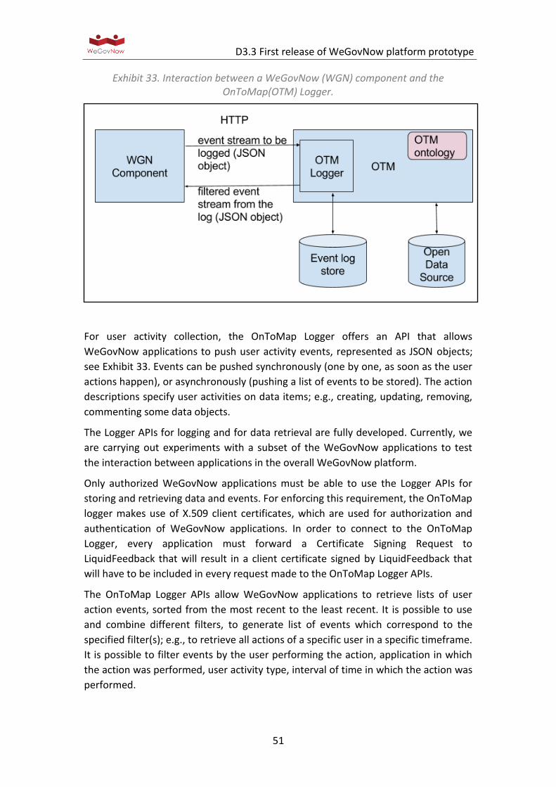
D3.3 First release of WeGovNow platform prototype
51
Exhibit 33. Interaction between a WeGovNow (WGN) component and the OnToMap(OTM) Logger.
For user activity collection, the OnToMap Logger offers an API that allows
WeGovNow applications to push user activity events, represented as JSON objects;
see Exhibit 33. Events can be pushed synchronously (one by one, as soon as the user
actions happen), or asynchronously (pushing a list of events to be stored). The action
descriptions specify user activities on data items; e.g., creating, updating, removing,
commenting some data objects.
The Logger APIs for logging and for data retrieval are fully developed. Currently, we
are carrying out experiments with a subset of the WeGovNow applications to test
the interaction between applications in the overall WeGovNow platform.
Only authorized WeGovNow applications must be able to use the Logger APIs for
storing and retrieving data and events. For enforcing this requirement, the OnToMap
logger makes use of X.509 client certificates, which are used for authorization and
authentication of WeGovNow applications. In order to connect to the OnToMap
Logger, every application must forward a Certificate Signing Request to
LiquidFeedback that will result in a client certificate signed by LiquidFeedback that
will have to be included in every request made to the OnToMap Logger APIs.
The OnToMap Logger APIs allow WeGovNow applications to retrieve lists of user
action events, sorted from the most recent to the least recent. It is possible to use
and combine different filters, to generate list of events which correspond to the
specified filter(s); e.g., to retrieve all actions of a specific user in a specific timeframe.
It is possible to filter events by the user performing the action, application in which
the action was performed, user activity type, interval of time in which the action was
performed.

D3.3 First release of WeGovNow platform prototype
52
Since, as previously described, the OnToMap Logger is also used to provide a unified
view on the data shared among the WeGovNow applications by users; it is possible
to filter the event data by some properties of the shared data items associated with
the events. This results in the Data Retrieval APIs described in the previous section.
Moreover, in addition to the previously cited filters, it is possible to filter the event
data by geographical area in which the shared data items are located, the concept of
which the shared data items are instances and the unique identifier associated with
every shared data item.
The OnToMap Logger documentation can be found at the following URL:
https://ontomap.eu/. This documentation reports the specification of the APIs, and
examples of usage with sample results.
In the following we report an example showing the invocation of the Logger API with
a very small set of sample results (in GeoJSON format): the query concerns the
instances of Park, with their descriptions and geometries, as collected by a
WeGovNow app denoted as App1. Obviously, more complex queries could be
performed, e.g., to specify the bounding box for retrieving instances, and other
parameters. See Appendix «Logger Endpoint»
InputMap
For the sake of integration, the entities within WeGovNow components need to be
interconnected. To create deeplinks and cross component references, we adopted as
solution based on the explicit input of users, a common component InputMap
(https://gitlab.dev.di.unito.it/firstlife/inputmap). InputMap is web-map meant to
collect user inputs about location, as a traditional web map, and about existing
entities.
The output of InputMap are (see Exhibit 34):
Latitude and Longitude
Zoom level, current zoom of the map
AreaId, identifier of the selected area (if applicable)
TileId, hash encode of tile
OSM Id, identifier of the geographical entity (if applicable)
Name of the geographical entity
Type of the geographical entity
InputMap can be used even when there are not geographical sources available. The
extra information about zoom level in combination with latitude and logitude can be
used to infer the reference later on, as new geographical sources are available. Tile
id is specifically meant to provide a reference to an area, to support the area-based
aggregation provided by AreaViewer.
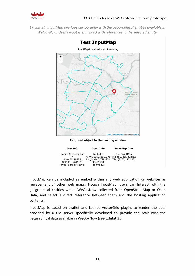
D3.3 First release of WeGovNow platform prototype
53
Exhibit 34. InputMap overlaps cartography with the geographical entities available in WeGovNow. User's input is enhanced with references to the selected entity.
InputMap can be included as embed within any web application or websites as
replacement of other web maps. Trough InputMap, users can interact with the
geographical entities within WeGovNow collected from OpenStreetMap or Open
Data, and select a direct reference between them and the hosting application
contents.
InputMap is based on Leaflet and Leaflet VectorGrid plugin, to render the data
provided by a tile server specifically developed to provide the scale-wise the
geographical data available in WeGovNow (see Exhibit 35).
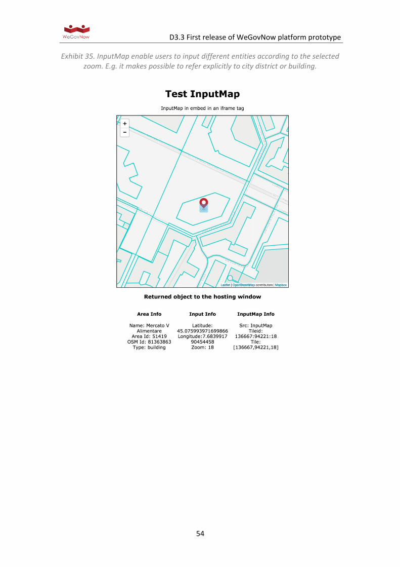
D3.3 First release of WeGovNow platform prototype
54
Exhibit 35. InputMap enable users to input different entities according to the selected zoom. E.g. it makes possible to refer explicitly to city district or building.

D3.3 First release of WeGovNow platform prototype
55
6. Ongoing development work
During the definition of The WeGovNow Consolidated System Architecture
(deliverable D3.1), the technical teams of WeGovNow identified unexpected
requirements for introducing new features to support the integration of WeGovNow
components. Moreover, the current WeGovNow components are not all at the same
stage of development: CommunityMap/GeoKey, LiquidFeedback, ImproveMyCity are
mature software adopted in several scenarios, FirstLife was at prototype stage,
adopted in pilot projects, and Trusted Marketplace is a completely new component
to be developed during WeGovNow project.
In the following subsections, further information is provided on those modules and
components which are currently under development. These are expected to be
released before the final version of WeGovNow platform.
6.1. User Management
User Management is a component introduced as extension of Trusted Marketplace
(TM) to provide a single entry-point to user’s preferences and data across
WeGovNow platform. User Management will extend the profile settings in UWUM
(see Exhibit 36), including the possibility to edit all information stored in UWUM
about the user by all WeGovNow components.
Exhibit 36. Mock-up of the User Profile Management page, extending the UWUM profile settings.
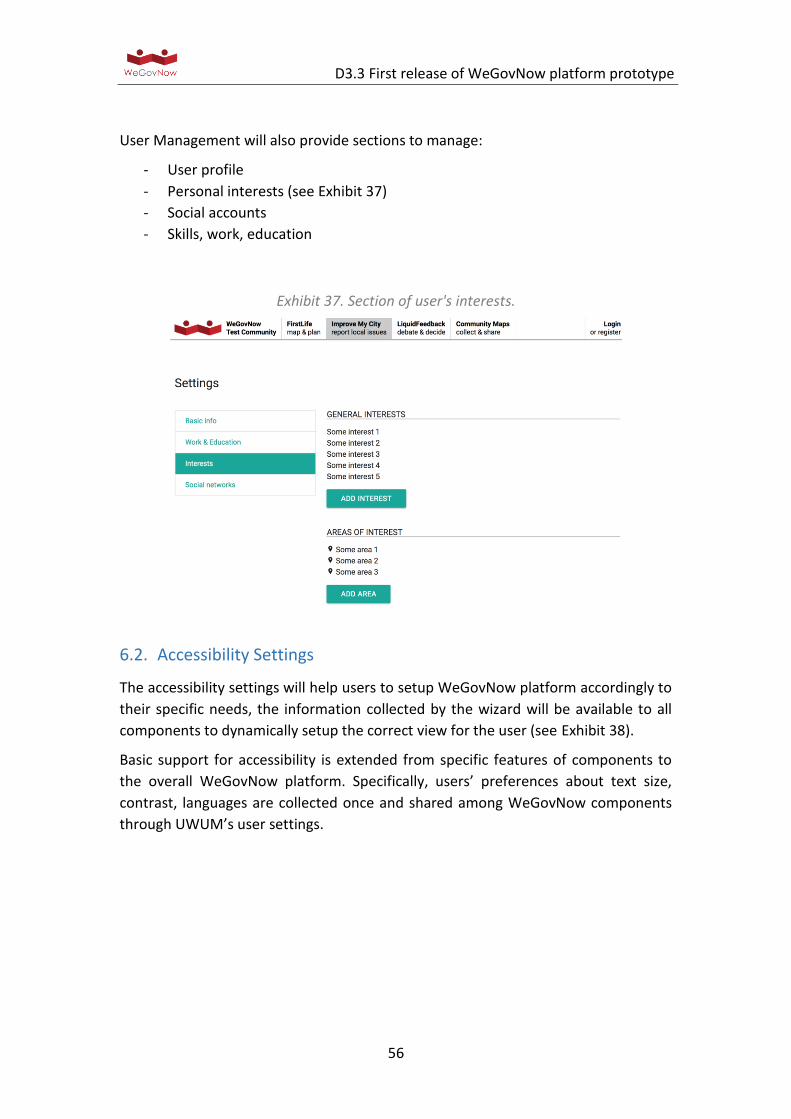
D3.3 First release of WeGovNow platform prototype
56
User Management will also provide sections to manage:
- User profile
- Personal interests (see Exhibit 37)
- Social accounts
- Skills, work, education
Exhibit 37. Section of user's interests.
6.2. Accessibility Settings
The accessibility settings will help users to setup WeGovNow platform accordingly to
their specific needs, the information collected by the wizard will be available to all
components to dynamically setup the correct view for the user (see Exhibit 38).
Basic support for accessibility is extended from specific features of components to
the overall WeGovNow platform. Specifically, users’ preferences about text size,
contrast, languages are collected once and shared among WeGovNow components
through UWUM’s user settings.
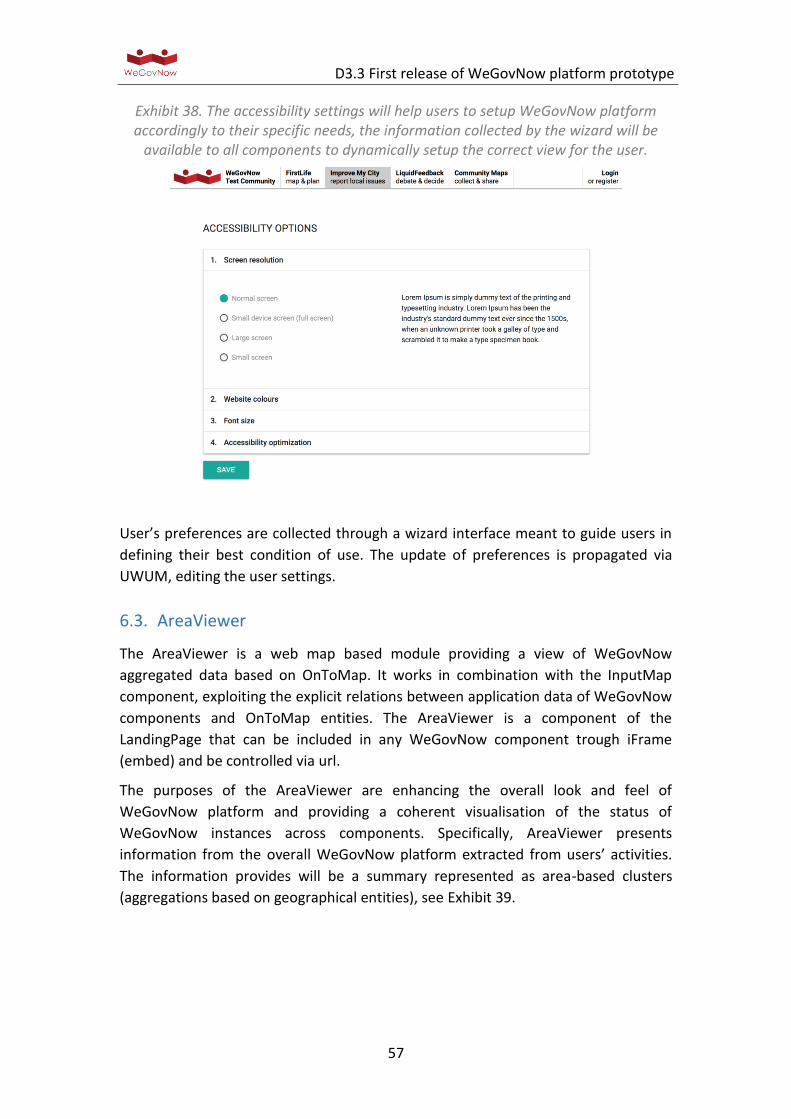
D3.3 First release of WeGovNow platform prototype
57
Exhibit 38. The accessibility settings will help users to setup WeGovNow platform accordingly to their specific needs, the information collected by the wizard will be
available to all components to dynamically setup the correct view for the user.
User’s preferences are collected through a wizard interface meant to guide users in
defining their best condition of use. The update of preferences is propagated via
UWUM, editing the user settings.
6.3. AreaViewer
The AreaViewer is a web map based module providing a view of WeGovNow
aggregated data based on OnToMap. It works in combination with the InputMap
component, exploiting the explicit relations between application data of WeGovNow
components and OnToMap entities. The AreaViewer is a component of the
LandingPage that can be included in any WeGovNow component trough iFrame
(embed) and be controlled via url.
The purposes of the AreaViewer are enhancing the overall look and feel of
WeGovNow platform and providing a coherent visualisation of the status of
WeGovNow instances across components. Specifically, AreaViewer presents
information from the overall WeGovNow platform extracted from users’ activities.
The information provides will be a summary represented as area-based clusters
(aggregations based on geographical entities), see Exhibit 39.
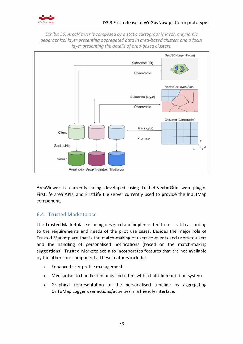
D3.3 First release of WeGovNow platform prototype
58
Exhibit 39. AreaViewer is composed by a static cartographic layer, a dynamic geographical layer presenting aggregated data in area-based clusters and a focus
layer presenting the details of area-based clusters.
AreaViewer is currently being developed using Leaflet.VectorGrid web plugin,
FirstLife area APIs, and FirstLife tile server currently used to provide the InputMap
component.
6.4. Trusted Marketplace
The Trusted Marketplace is being designed and implemented from scratch according
to the requirements and needs of the pilot use cases. Besides the major role of
Trusted Marketplace that is the match-making of users-to-events and users-to-users
and the handling of personalised notifications (based on the match-making
suggestions), Trusted Marketplace also incorporates features that are not available
by the other core components. These features include:
Enhanced user profile management
Mechanism to handle demands and offers with a built-in reputation system.
Graphical representation of the personalised timeline by aggregating
OnToMap Logger user actions/activities in a friendly interface.
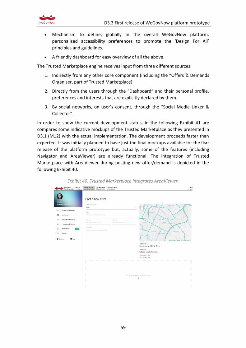
D3.3 First release of WeGovNow platform prototype
59
Mechanism to define, globally in the overall WeGovNow platform,
personalised accessibility preferences to promote the ‘Design For All’
principles and guidelines.
A friendly dashboard for easy overview of all the above.
The Trusted Marketplace engine receives input from three different sources.
1. Indirectly from any other core component (including the “Offers & Demands
Organiser, part of Trusted Marketplace)
2. Directly from the users through the “Dashboard” and their personal profile,
preferences and interests that are explicitly declared by them.
3. By social networks, on user’s consent, through the “Social Media Linker &
Collector”.
In order to show the current development status, in the following Exhibit 41 are
compares some indicative mockups of the Trusted Marketplace as they presented in
D3.1 (M12) with the actual implementation. The development proceeds faster than
expected. It was initially planned to have just the final mockups available for the fisrt
release of the platform prototype but, actually, some of the features (including
Navigator and AreaViewer) are already functional. The integration of Trusted
Marketplace with AreaViewer during posting new offer/demand is depicted in the
following Exhibit 40.
Exhibit 40. Trusted Marketplace integrates AreaViewer.
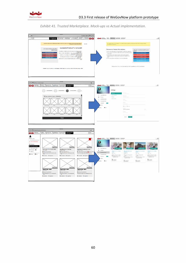
D3.3 First release of WeGovNow platform prototype
60
Exhibit 41. Trusted Marketplace. Mock-ups vs Actual implementation.

D3.3 First release of WeGovNow platform prototype
61
Annexes
List of Annexes:
1. Logger Endpoint
2. UWUM integration
3. LiquidFeedback work report
4. UWUM work report
5. PgLatLon work report
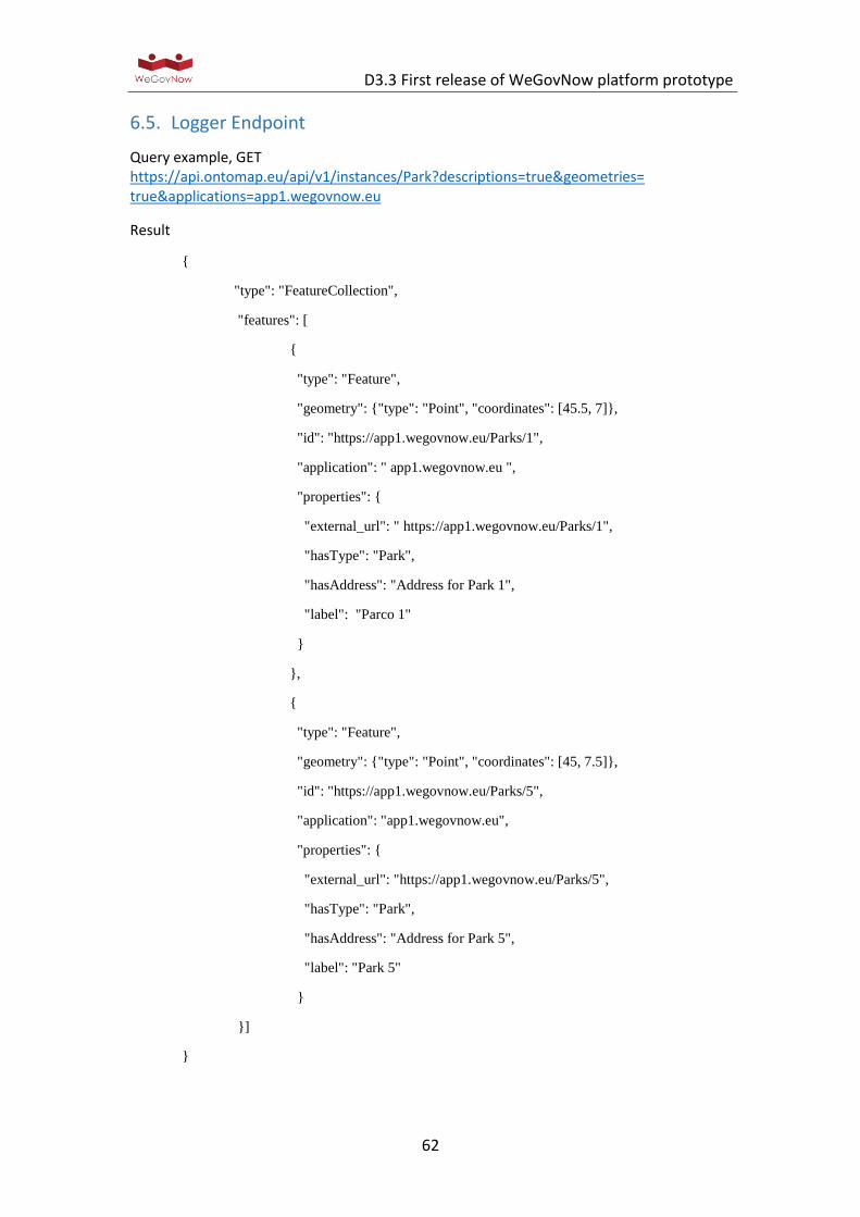
D3.3 First release of WeGovNow platform prototype
62
6.5. Logger Endpoint
Query example, GET https://api.ontomap.eu/api/v1/instances/Park?descriptions=true&geometries=true&applications=app1.wegovnow.eu
Result
{
"type": "FeatureCollection",
"features": [
{
"type": "Feature",
"geometry": {"type": "Point", "coordinates": [45.5, 7]},
"id": "https://app1.wegovnow.eu/Parks/1",
"application": " app1.wegovnow.eu ",
"properties": {
"external_url": " https://app1.wegovnow.eu/Parks/1",
"hasType": "Park",
"hasAddress": "Address for Park 1",
"label": "Parco 1"
}
},
{
"type": "Feature",
"geometry": {"type": "Point", "coordinates": [45, 7.5]},
"id": "https://app1.wegovnow.eu/Parks/5",
"application": "app1.wegovnow.eu",
"properties": {
"external_url": "https://app1.wegovnow.eu/Parks/5",
"hasType": "Park",
"hasAddress": "Address for Park 5",
"label": "Park 5"
}
}]
}
D3.3 First release of WeGovNow platform prototype
63
6.6. UWUM Integration
UWUM API endpoints
The UWUM endpoints for OAuth2 and the integration framework are available at the
following URLs:
https://wegovnow.liquidfeedback.com/api/1/authorization
https://wegovnow.liquidfeedback.com/api/1/token
https://wegovnow.liquidfeedback.com/api/1/validate
https://wegovnow.liquidfeedback.com/api/1/navigation
https://wegovnow.liquidfeedback.com/api/1/style
https://wegovnow.liquidfeedback.com/api/1/client
UWUM scopes
Currently the following access scopes can be granted through UWUM (based on the
access levels of LiquidFeedback):
- “authentication” authenticate the current user by reading its
o static ID (id)
o current screen name (name)
- “identification” identify the current user by reading its unique ident string
(identification). Automatically implies scope "authentication"
- “notify_email” read the notification email address of the current user
(notify_email)
- “read_contents” read any user generated content (w/o authorship, ratings
and votes)
- “read_authors” read the author names of user generated content (author's
static ID and screen name)
- “read_ratings” read rating scores by other users
- “read_identities” read the identities of other users (identification)
- “read_profiles” read the profiles of other users (e.g. phone number, self-
description)
- “post” post new content
- “rate” rate user generated content (e.g. thumbs up/down, "+1", support an
initiative, rate a suggestion)
- “vote” finally vote for/against user generated content in a decision (i.e. vote
on an issue)
- “profile” read profile data of current user (e.g. phone number, self-
description, ...)
D3.3 First release of WeGovNow platform prototype
64
- “settings” read current user's settings (e.g. notification settings, display
contrast, ...)
- “update_name” modify user's screen name (name)
- “update_notify_email” modify user's notification email address (notify_email)
- “update_profile” modify profile data (e.g. phone number, self-description, ...)
- “update_settings” modify user settings (e.g. notification settings, display
contrast, ...)
Any of these scopes can be suffixed with "_detached" to request the scope for usage
without the need for the user to be logged in. This should only be used when it is
really needed.
X.509 certificate for client identification
To create a trustworthy relationship between applications using UWUM and the
central UWUM component, we will use X.509 certificates. Therefor, any official
WeGovNow client is required to provide a valid X.509 certificate with each request
made to the central UWUM service. For this purpose we kindly ask all technical
partners to provide X.509 certificate signing requests to be signed by
the UWUM Certificate Authority.
For more information on X.509 certificates and signing requests, please refer to the
documentation of your preferred TLS software such as LibreSSL or OpenSSL.
Integration Checklist
We will support all technical partners during UWUM integration. We defined a
number of steps we like to take together with every technical partner. In the
following list, the term "client application" refers to the application to be integrated
with UWUM:
1. Availability of application via IPv4. The client application is available via a defined URL using IPv4.
2. Availability of application via IPv6. The client application is also available using IPv6.
3. Serving via HTTPS. The client application service is encrypted via HTTPS.
4. Publicly trusted X.509 certificate for end users. The client application server provides a publicly trusted X.509 certificate.
5. OAuth2 redirection endpoint defined. The URL of the OAuth2 redirection endpoint of the client application has been determined and submitted to LiquidFeedback (FlexiGuided GmbH).
D3.3 First release of WeGovNow platform prototype
65
6. Certificate signing request for UWUM. A private key for accessing the UWUM API has been created. A corresponding certificate signing request (CSR) has been submitted to LiquidFeedback (FlexiGuided GmbH).
7. Certificate signed by UWUM Certificate Authority. A signed certificate for the client application has been sent back to the technical partner.
8. Successful X.509 secured connection. The client application has successfully established a secured connection with the UWUM server, e.g. using LiquidFeedback's /info API endpoint.
9. Authorization endpoint access. The client application can redirect an end user to the UWUM authorization endpoint.
10. Authorization endpoint error response handling. The client application is capable of receiving authorization errors through its OAuth2 endpoint.
11. Authorization endpoint error display. The client application is able to display authorization error messages (see 10) to the end user.
12. Successful authorization request and user identification. The client application made a successful authorization request, received a UWUM access token, and determined the end user ID.
13. Using access token for API calls to other components. The client application has successfully performed a LiquidFeedback API call (e.g. to the /info API endpoint) using a previously obtained UWUM access token.
14. Accepting access token from other components. The client application (acting as resource server) provides at least one API call which accepts a UWUM access token for authorization.
15. Access token verification. The client application (acting as resource server) is capable of verifying the validity and scope of a UWUM access token passed from another component (see 14).
16. Access token verification errors. The client application (acting as resource server) is capable of handling error responses during validation of UWUM tokens (see 15).
17. Accepting access tokens as "Authorization" header. In conformance with RFC 6750 (Bearer Token Usage), the client application (acting as resource server) accepts UWUM access tokens through the HTTP request header field "Authorization".
18. Cross-origin resource sharing (CORS). The client application (acting as resource server) allows cross-origin resource sharing (CORS). See also https://www.w3.org/TR/cors/.
D3.3 First release of WeGovNow platform prototype
66
19. HTTP Strict Transport Security (HSTS). The client application ensures secure access by using HTTP Strict Transport Security (HSTS) according to RFC 6797.
20. Cross-application navigation. The UWUM navigation bar has been successfully integrated into the client application.
Usage of scopes / screen name
When acting as WeGovNow UWUM client without data exchange with other
WeGovNow applications, you will only need to request the "authentication" or the
"identification" scope to be able to identify the user. These scopes allow to retrieve
some user related information (i.e. numerical ID, identification string, screen name)
to identify the user. When using the "authentication" or the "identification" scope,
the response of the /api/1/token endpoint can optionally include an additional data
structure providing member information. To request this optional "member" data
structure, you need to set the parameter "include_member" to 1 or "true". Using the
"identification" scope with the parameter "include_member" set to true, the
response to the /api/1/token endpoint could look like as follows:
{
"access_token": "UFYPzKrz7JHIKATI",
"expires_in": 3600,
"refresh_token": "5QM8OL7AbdabXusG",
"token_type": "bearer",
"member_id": 123,
"member": {
"id": 123,
"name": "Johnny",
"identification": "John Doe"
}
}
The field "id" of the "member" object contains the static numerical ID of the user
(equal to "member_id", i.e. redundant), the field "name" contains the screen name
chosen by the user, the field "identification" contains the identification string set by
the authority which identified the user as unique and eligible to use the WeGovNow
application. In future, there may be more fields according to the upcoming
specification of the /api/1/member endpoint of LiquidFeedback.
The parameter "include_member" can also be used at the /api/1/validate and the
/api/1/info endpoints.
D3.3 First release of WeGovNow platform prototype
67
When acting as WeGovNow application using user related data or services of other
WeGovNow applications, you will need to request the appropriate scopes from
UWUM for the types of actions you want to perform with other WeGovNow
applications (e.g. if you want to post new content to other applications, request the
scope "post"; if you want to rate content in other applications request the scope
"rate"; ...)
When acting as WeGovNow resource server (i.e. when offering user related data or
services to other WeGovNow applications) you need to check (via the /api/1/validate
endpoint) the scopes of the access token you received from the requesting
application (e.g. if another application tries to post content for a user, check for
scope "post"; if another application tries to rate content, check for the scope "rate").
Handling of updated user related data / user's email addresses
When a WeGovNow application wants to send notification emails to users, it is not
adequate to retrieve the email address only once from UWUM as the notification
email can be changed by the user at any time. Such a change needs to be reflected
by all applications using this email address. Therefore, an application needs to
retrieve the current notification email address *directly* before using it, in fact again
before every usage.
For that purpose, the newly introduced API endpoint GET /api/1/notify_email can be
used (using an access token with the "notify_email" scope). To be able to retrieve
the email address while the user is not currently logged in, it will be neccessary to
request the "notify_email_detached" scope when identifying the user and to store
the received refresh token permanently. The suffix "_detached" requests a scope for
detached usage, i.e. for usage even after the user logs out. Please note, when
exchanging a refresh token for an access token after the user has been logged out,
you must explicitly request the "*_detached" scope(s) you need, e.g.
"notify_email_detached" using the scope parameter of the /api/1/token endpoint.
Similar situations can occur related to other member properties stored in one
application but used in another one, e.g. the screen name. But these seem not to be
as critical as to avoid using an outdated email address. Such properties could be
cached for a limited time before retrieving them again from the application storing
this property.
Sustainability, unregistered third-party clients and the future
Following these rules, even a complete new (non-registered, third-party) application
can easily make use of the WeGovNow infrastructure. The application can request
certain scopes from UWUM (which can be granted or declined by the user) and use
D3.3 First release of WeGovNow platform prototype
68
the appropriate services of all other WeGovNow applications. Using the upcoming
application and service discovery, this is also possible vice versa.
Scopes vs. User Privileges
NB: The scope does NOT grant a privilege to a user, it just means an application can
trigger an action within the scope *if* the user is authorized to perform the action.
Example voting: an application needs the scope "vote" to cast a vote on behalf of the
user but casting a vote will only work if the user has the necessary voting privileges.
You can think of this as a matrix of scopes and user privileges or (alternatively) as a
logical AND conjunction. Scopes control that an application does not misuse user
privileges: while the trusted WeGovNow applications can request certain scopes
without user interaction, a non-trusted third-party application/client would trigger a
request for a confirmation by the user "Do you want to allow application X to cast
votes on your behalf? [yes, one time / yes, permanently]" (compare to permissions
for third party Twitter/Facebook clients and Android permissions).

Appendix 6.3 LiquidFeedback work report
Second work report on extending theLiquidFeedback Core
Jan Behrens, Andreas Nitsche, Bjorn Swierczek
April 19, 2017
© 2017 FlexiGuided GmbH, Berlin
1 Overview on tasks
1.1 Open tasks listed in work report from June 6, 2016
The first work report on extending the LiquidFeedback Core (dated June 6,2016)1 listed the following three remaining tasks:
1. Adjustment of the background counting program (“lf update”) to reflectthe implemented changes for the new issue admission process.
2. Improvements to geospatial indexing and radial searches.
3. A complete dependency and license review of all WeGovNow software com-ponents.
The first task of adjusting the background counting program “lf update”has been completed (see section 3). As for the second task, the geospatial in-dexing method has been completely revised with publication of pgLatLon (see“Work report on ‘pgLatLon’, an alternative to PostGIS”2 from August 19, 2016).pgLatLon’s geospatial index also contains support for radial searches using Post-greSQL’s GiST interface. These and other features are also documented inpgLatLon’s online documentation, which can be downloaded at its project page3.The results of the third task (dependency and license review) have already beendocumented in Deliverable D1.2 (“Consolidated conceptual & methodologicalframework v2”) and will not be part of this work report.
1included as Appendix 3.5 to Deliverable D3.1, pages 171 through 1902included as Appendix 7.1 to Deliverable D3.1, pages 212 through 2273http://www.public-software-group.org/pgLatLon
1/10
2nd Work Report on LF Core Extension LiquidFeedback / FlexiGuided GmbH
1.2 Additional tasks
1.2.1 Further adjustments to LiquidFeedback’s issue admission mech-anism
At the time of writing the previous work report (June 6, 2016), LiquidFeedback’sdraft for an issue admission mechanism not depending on “subject area mem-bership”4 was based on admitting the most supported issue within a given timeframe. Apart from difficulties with visualization, further considerations revealedthat such an approach lacks the ability to respond to dynamic changes in theactivity of the participants or their demand to discuss several issues at once whileno issues are being discussed at other times.
Nonetheless, LiquidFeedback’s previous issue admission system is unsuitablefor integration with WeGovNow (due to the “subject area memberships” thatare infeasible in the context of WeGovNow). Therefore, the new issue admissionsystem has been modified further, including necessary changes to the Liquid-Feedback Core. The final issue admission system is described in section 2 of thiswork report.
1.2.2 Adding necessary data structures for the Unified WeGovNowUser Management (UWUM)
The necessary data structures for UWUM had to be added to the LiquidFeedbackCore. The main work on the Core has already been done by end of August 2016,when the UWUM work report5 was published. Section 5 below will give a list ofall UWUM related modifications to the LiquidFeedback Core.
1.2.3 Event logging
As part of LiquidFeedback’s API implementation, data structures and triggershad to be created in the LiquidFeedback Core SQL schema. A list of all loggedevents is given in section 4.
1.2.4 Providing update capabilities for LiquidFeedback 3
LiquidFeedback provides a smooth upgrade path from version 1.0.0 through themost recent published version 3.2.2. Automatic SQL scripts convert the databaseof one LiquidFeedback version to the next higher version. This enables users of
4See section 2.1 of the first work report on extending the LiquidFeedback Core.5included as Appendix 2.1.2 to Deliverable D3.1, pages 124 through 151
2/10
2nd Work Report on LF Core Extension LiquidFeedback / FlexiGuided GmbH
LiquidFeedback (e.g. municipalities or organizations using the software) to ben-efit from future updates. In order to keep this upgrade path intact, all modi-fications to the LiquidFeedback Core database schema were condensed into anupgrade file (“update script”) that may be executed on a LiquidFeedback v3.2.2database, which then gets automatically updated to incorporate all changes madefor WeGovNow. The work done to create the update script is discussed in sec-tion 6.
2 Modifications to LiquidFeedback’s issue admis-sion system
Until LiquidFeedback version 3.2.2, user generated issues required to pass a cer-tain supporter quorum in order to be further discussed. The quorum (e.g. 10%)used a reference population that was determined through so-called “member-ships” in subject areas.6 While this approach is limited in regard to scalability,7
it also does not integrate well with the architecture of WeGovNow and potentiallyother integrated systems developed in the future.
After considering different approaches, including the approaches described in[8] and [9], a simple yet powerful mechanism was created to control the admissionof issues for the discussion phase in LiquidFeedback, which will be described inthe following three subsections.
2.1 Issue quorum based on active participants
The first measure to modify the issue admission mechanism is to base the existingsupporter quorum on a population that is not calculated based on the “member-
6See section 4.9 (pages 71 and 72) in “The Principles of LiquidFeedback”, ISBN 978–3–00–044795–2.
7A minority exceeding the supporter quorum may create a flood of issues, see “TheEvolution of Proportional Representation in LiquidFeedback” in “The Liquid Democ-racy Journal on electronic participation, collective moderation, and voting systems”,Issue 1. ISSN 2198–9532. http://www.liquid-democracy-journal.org/issue/1/
The_Liquid_Democracy_Journal-Issue001-04-The_evolution_of_proportional_
representation_in_LiquidFeedback.html8“A Finite Discourse Space for an Infinite Number Of Participants” in “The Liquid
Democracy Journal on electronic participation, collective moderation, and voting systems”,Issue 4. ISSN 2198–9532. http://www.liquid-democracy-journal.org/issue/4/
The_Liquid_Democracy_Journal-Issue004-02-A_Finite_Discourse_Space_for_an_
Infinite_Number_of_Participants.html9“LiquidFeedback 2.x discontinued, LiquidFeedback 3.1 released, LiquidFeedback 4 devel-
opment started”, December 14, 2015, on the LiquidFeedback developer mailinglist. http:
//dev.liquidfeedback.org/pipermail/main/2015-December/000532.html
3/10
2nd Work Report on LF Core Extension LiquidFeedback / FlexiGuided GmbH
ship” in subject areas (as described in [6]), but rather on all active participants10.This avoids the need of users to decide (and declare through LiquidFeedback’suser interface) in which subject areas they plan to engage in.
Naturally, using the total count of active participants as reference for thesupporter quorum results in a higher barrier for new initiatives. Therefore, theissue quorum should be set to a very low value (or may even be entirely disabled)to also allow small minorities to engage in the proposition development and de-cision making process of LiquidFeedback. At the same time, additional measuresare required to ensure managability for the participants when also possibly verysmall minorities are able to influence the agenda. These measures are describedin the next subsection 2.2.
2.2 Issue limiter
The newly developed LiquidFeedback issue limiter ensures that the number ofopen issues11 in a subject area does not grow unboundedly by using the number ofopen issues as a feedback for dynamically adjusting the supporter count requiredfor admission of a new issue. For considerations on democratic fairness of suchan approach, especially in regard to protection of minorities, refer to [8].
The basic principle is that increasing the number of open issues by a givenabsolute count increases the required supporter count by a certain (constant)factor. In turn, issues that are closed (e.g. because of finally having been votedupon) reduce the required suppoter count by the same factor. This results inan exponential correlation between the number of open issues and the currentlyrequired supporter count to let a new issue pass to discussion phase.
Using S to denote the required supporter count, B0 to denote the desiredsupporter count when no issues are open, and n as the number of open issues,the relation can (simplified) be described as follows:
S = B0 · f n1
with f1 ∈ R+ being a configurable factor. In order to simplify configuration, theformula can also be expressed as:
S = BN · fnN−1
N
with an arbitrary N ∈ N, fN = f N1 , and BN = B0 · fN . In this case, S is
the actual required supporter count, BN is the required supporter count if N
10This includes all participants which (a) are eligible to vote in a given unit and (b) havelogged in recently, i.e. within a configurable time in the recent past.
11In this context, we use the term “open issues” to refer to all issues that have been acceptedfor discussion but not been closed yet, i.e. all issues that are in discussion, verification, or votingphase.
4/10
2nd Work Report on LF Core Extension LiquidFeedback / FlexiGuided GmbH
issues were open, and fN is a factor (or divisor) by which the supporter count ismodified if N more (or less, respectively) issues are open.
The variables BN , fN , and N correspond to the following new columns ofthe area (subject area) table in the LiquidFeedback Core SQL schema12:
BN quorum standard
fN quorum factor
N quorum issues
The described approach doesn’t yet take into account that different issuesmay have different runtimes. Counterintuitively, open issues that have a shorterruntime should be weighted more (i.e. a shorter runtime of an open issue shouldincrease the required supporter count) because an equillibrium of N open issuesthat have a short runtime require more interactions of the participants than Nopen issues with a longer runtime.
Taking different runtimes into account, the number S of required supporterscalculates as follows:
S = BN · fn∗N
−1
N
with
n∗ =∑i
(diD
)−a
where di is the total runtime of an issue i after admission for discussion phase(i.e. discussion time + verification time + voting time), D is a reference runtime(e.g. runtime of a default policy), and a ∈ [0, 1] is an exponent selecting howmuch the runtimes of different issues are taken into account.
While the exponential relationship between open issues and the required sup-porter count doesn’t need to take the total number of active participants intoaccount, the implementation of the issue limiter still allows to use a relative basequorum (QN) instead of an absolute number of required supporters (BN). Inthis case, BN = QN ·M , where M is the total number of active10 participants.
LiquidFeedback’s SQL schema12 names all the configurable variables as fol-lows:
BN quorum standard (if quorum den is NULL)fN quorum factor
N quorum issues
D quorum time
a quorum exponent
QN quorum standard divided by quorum den
12Refer to the definition of the area table in the LiquidFeedback Core SQLschema file: http://www.public-software-group.org/mercurial/liquid_feedback_
core/file/5855ff9e5c8f/core.sql#l636
5/10
2nd Work Report on LF Core Extension LiquidFeedback / FlexiGuided GmbH
Refer to the LiquidFeedback Core SQL schema file (particularly the defini-tion of the “area quorum” view on lines 3164 through 3200)13 for the actualimplementation.
2.3 Resulting quorum
An issue passing from admission to discussion phase must fulfill both the demandsstated in subsection 2.1 and subsection 2.2. Therefore, the required supportercount is always the maximum of the issue quorum (using the total number ofactive participants as a reference) and the supporter count determined by theissue limiter as described in subsection 2.2.
3 Vote and supporter counting
As already noted in subsection 1.1, LiquidFeedback’s background counting pro-gram (“lf update”) had to be adjusted to reflect the implemented changesfor the new issue admission process. In addition to work on this program, thesnapshot mechanism14 needed further changes to be capable of documenting theset of active10 participants at a particular point in time (the number of activeparticipants is required by the issue admission system described in section 2 ofthis work report).
4 Event logging
The LiquidFeedback Core has been extended to additionally log the followingevents:
• suggestion removed: A suggestion has been deleted.
• member activated: A participant has activated his or her account for thefirst time.
• member removed: An account has been permanently disabled or removed.
• member active: The “active” status of a participant changed. (A par-ticipant is marked inactive when he or she hasn’t log in for a configurablelength of time.)
13http://www.public-software-group.org/mercurial/liquid_feedback_core/
file/5855ff9e5c8f/core.sql#l316414See section 5.3 (pages 116 and 117) in “The Principles of LiquidFeedback”, ISBN 978–
3–00–044795–2.
6/10
2nd Work Report on LF Core Extension LiquidFeedback / FlexiGuided GmbH
• member name updated: A participant changed his or her screen name.
• member profile updated: A participant updated his or her profile.
• member image updated: A participant updated his or her images.
• interest: A participant added or removed interest in an issue.
• initiator: A participant was added to or removed from the list of initia-tors of an initiative.
• support: A participant supported an initiative or removed his or her sup-port.
• support updated: A participant updated his or her supported revision tothe most recent revision of an initiative.
• suggestion rated: A suggestion has been rated by a participant.
• delegation: A delegation has been set or removed.
• contact: A contact has been published or unpublished.
These events complement the previously existing events:
• issue state changed: An issue passed from admission phase to discus-sion phase, from discussion phase to verification phase, from verificationphase to voting phase, or got closed.
• initiative created in new issue: A new issue was created.
• initiative created in existing issue: A new initiative was createdin an existing issue.
• initiative revoked: An initiator revoked his or her initiative.
• new draft created: The initiative text has been updated.
• suggestion created: A new suggestion for an initiative was added.
The above logging functionality has been implemented using triggers. Due toother existing triggers (including referential triggers), special care had to be takenin regard to the trigger firing order. PostgreSQL fires triggers in the followingorder:
7/10
2nd Work Report on LF Core Extension LiquidFeedback / FlexiGuided GmbH
1. BEFORE (regular trigger)
2. BEFORE (constraint trigger)
3. AFTER (constraint trigger)
4. AFTER (regular trigger)
Implementing the above event logging triggers as regular AFTER triggers solvedconflicts with other triggers. However, additional checks had to be implementedin some event logging triggers to avoid event logging due to referential cascades;e.g. deletion of old issues should not cause logging of revoked delegations forthose issues.15
5 UWUM
The following tables16 have been added to the LiquidFeedback Core SQL schemain order to store UWUM related data:
• system application: to store OAuth 2.0 clients known to the operatorof a LiquidFeedback/WeGovNow platform
• system application redirect uri: to store additional (non-default)redirect URIs for the OAuth 2.0 flow
• dynamic application scope: to store dynamically registered OAuth 2.0clients with their scope
• member application: to store privileges granted by participants to par-ticular OAuth 2.0 clients
• token: to store issued OAuth 2.0 tokens and authorization codes
• token scope: to temporarily store additional sets of scopes for autho-rization codes when multiple different scopes were requested during theAuthorization Code flow17
15For an example, refer to the TG OP='DELETE' part of the write event delegation()
trigger in the LiquidFeedback Core SQL schema file on lines 2372 through 2428, which requiresthat the corresponding organizational unit, subject area, or issue has not been deleted by thetime of execution of the logging trigger (in which case the deletion was not a user action butthe consequence of a referential constraint with ON DELETE CASCADE clause).
16See lines 356 through 483 of the LiquidFeedback Core SQL schema: http:
//www.public-software-group.org/mercurial/liquid_feedback_core/file/
5855ff9e5c8f/core.sql#l35617an extension to the OAuth 2.0 standard; refer to subsection 2.13 of the UWUM work
report5
8/10
2nd Work Report on LF Core Extension LiquidFeedback / FlexiGuided GmbH
Additional triggers18 ensure that tokens are automatically invalidated and/orreduced in regard to their OAuth 2.0 scope when a participant logs out.19
Apart from the automatically generated PRIMARY KEY and UNIQUE in-dices,20 additional indices were created where applicable to speed up databaseoperations.
6 Update capabilities from LiquidFeedback 3
In order to enable users of previous LiquidFeedback versions to incorporate theimplmented features, an update script has been created that converts a Liquid-Feedback 3.2.2 database to the new format.
Because certain internal structures of LiquidFeedback were modified (such asthe snapshot system or parts of the session management), the process of creatingthe update script had to be reviewed manually (with the help of automatic “diff”tools). The resulting update script21 has a size of more than 140 kilobytes andcontains:
• 98 “ALTER TABLE” statements, consisting of
– 29 “ALTER TABLE ... ADD COLUMN” statements,
– 18 “ALTER TABLE ... DROP COLUMN” statements,
– 1 “ALTER TABLE ... ALTER COLUMN” statement,
– 30 “ALTER TABLE ... ADD CONSTRAINT”22 statements,
– 14 “ALTER TABLE ... DROP CONSTRAINT” statements,
– 4 “ALTER TABLE ... RENAME TO” statements,
– 2 “ALTER TABLE DISABLE/ENABLE TRIGGER” statements,
• 15 “CREATE TABLE” statements,
• 8 “DROP TABLE” statements,
18See lines 2509 through 2584 of the LiquidFeedback Core SQL schema:http://www.public-software-group.org/mercurial/liquid_feedback_core/file/
5855ff9e5c8f/core.sql#l250919See also subsection 2.9 on binding the lifetime of access and refresh tokens to a user’s
web session by default in the UWUM work report5.20Note that PostgreSQL automatically creates indices for all PRIMARY KEY and UNIQUE
constraints in a table, but not on columns covered by FOREIGN KEY constraints.21http://www.public-software-group.org/mercurial/liquid_feedback_core/
file/5855ff9e5c8f/update/core-update.v3.2.2-v4.0.0.sql22including ADD PRIMARY KEY, ADD FOREIGN KEY, and ADD UNIQUE statements
9/10

2nd Work Report on LF Core Extension LiquidFeedback / FlexiGuided GmbH
• 25 “CREATE INDEX” statements,
• 3 “DROP INDEX” statements,
• 22 “CREATE (OR REPLACE) VIEW” statements,
• 9 “DROP VIEW” statements,
• 4 “CREATE (OR REPLACE) RULE” statements,
• 35 “CREATE (OR REPLACE) FUNCTION” statements,
• and 145 “COMMENT ON” statements.
7 Publication of results
The developed changesets (including the update script as mentioned in section 6)have been submitted to the Public Software Group e. V on March 30, 2017 andwere published by the Public Software Group in the source code repository ofLiquidFeedback Core23 under the terms of the MIT-License24 on March 30, 2017.
© 2017 FlexiGuided GmbH, Berlin
23http://www.public-software-group.org/mercurial/liquid_feedback_core/
rev/5855ff9e5c8f24http://www.public-software-group.org/mercurial/liquid_feedback_core/
file/d88fd3ae32d2/LICENSE
10/10

Appendix 6.4 UWUM work report
Work report on Unified WeGovNow UserManagement (UWUM) development
Jan Behrens, Axel Kistner, Andreas Nitsche, Bjorn Swierczek
2016-12-12
© 2016 FlexiGuided GmbH, Berlin
1 Presentation of UWUM in Berlin
A first draft of UWUM has been presented in the kick-off meeting “ConnectingThe Bits” on April 14, 2016 in Berlin. The overall idea was to build a single-sign-on (SSO) solution on OAuth 2.0’s Authorization Code1 flow.
For access tokens, the use of bearer tokens2 was proposed. Furthermore,it was agreed on that TLS is to be used to secure all communication betweenUWUM and other components.
In addition to single-sign-on, UWUM’s capabilities were planned to include:
• a style endpoint, which allows applications to retrieve style information(e.g. a color scheme),
• a navigation endpoint, which allows applications to incorporate a commonnagivation bar into their user interfaces, and
• a service discovery endpoint, which allows applications to retrieve a list ofother applications within the system and their capabilities/protocols.
This way, WeGovNow is designed to be a modular system that may be extendedwith different services which are all connected through UWUM.
It was agreed that UWUM will be implemented by LiquidFeedback such thatit is possible to use synergetic effects between the necessary creation of an APIfor LiquidFeedback and the newly created features required by UWUM.
1See https://tools.ietf.org/html/rfc6749#section-1.3.1 for a short overview onthe Authorization Code flow and https://tools.ietf.org/html/rfc6749#section-4.1
for a detailed description.2https://tools.ietf.org/html/rfc6750
1/27
UWUM Work Report LiquidFeedback / FlexiGuided GmbH
2 Authentication and Authorization
For reasons of interoperability and security, we aimed to create an implementationthat is fully compliant with RFC 6749.3 In this section, the extensions necessaryin addition to that document will be explained below. All functionality has beenimplemented by the time of publishing this work report except where otherwisenoted.
2.1 Roles
RFC 6749 defines several roles in subsection 1.1.4 The UWUM component asimplemented by LiquidFeedback takes the role of the “authorization server”.Other WeGovNow components will take the role of “clients” but may also actas “resource server” for other components.
2.2 Choice of protocol flow
UWUM requires the Authorization Code flow1 for secure user authentication, i.e.when used for single-sign-on (SSO). (Note that subsection 10.16 in RFC 6749explains why the Implicit flow5 as defined by OAuth 2.0 is not suitable for secureuser authentication.6)
The Implicit flow5 is still supported for clients which only require authorizationbut do not rely on secure user authentication (e.g. pure JavaScript clients whichaccess other components but do not store themselves any resources which wouldneed to be protected by SSO).
2.3 Types of clients
RFC 6749 distinguishes between “confidential clients” (which are capable ofsecure client authentication, e.g. by maintaining confidentiality of their clientcredentials) and “public clients” (which are incapable of secure client authenti-cation). UWUM requires all clients which use OAuth 2.0’s Authorization Code1
flow (and thus receive long-lasting refresh tokens) to be capable of secure au-thentication; i.e. every use of the token endpoint (see subsections 2.7 and 2.8)will require client authentication (except when an access token scope downgrade
3https://tools.ietf.org/html/rfc67494https://tools.ietf.org/html/rfc6749#section-1.15See https://tools.ietf.org/html/rfc6749#section-1.3.2 for a short overview on
the Implicit flow and https://tools.ietf.org/html/rfc6749#section-4.2 for a detaileddescription.
6https://tools.ietf.org/html/rfc6749#section-10.16
2/27
UWUM Work Report LiquidFeedback / FlexiGuided GmbH
is performed, see subsection 2.14). The use of “public clients” is only supportedfor those clients which utilize the Implicit5 flow because these clients will nothandle any long-lasting tokens.
2.4 Client registration
Client registration is mentioned in section 2 of RFC 6749, even though thestandard explicitly states that “the means through which the client registers withthe authorization server are beyond the scope of [the] specification”.56 UWUMprovides two methods of client registration:
• registering clients through the municipality (or their technical administra-tion) or an organization running a particular installation of WeGovNow,
• registration of any other (“dynamic”) client on a per-user basis by each userwho wishes to use that client to access WeGovNow (machine accessibility).
These two registration methods are described in the following two subsectionsrespectively.
2.4.1 Clients approved by the municipality
Clients approved by the municipality authenticate through TLS (X.509) certifi-cates which are signed by the municipality or a certificate authority acting ontheir behalf. For example, the operator of the UWUM server could issue a cer-tificate to the operator of each respective client. Furthermore, the operator ofthe UWUM server configures a list of automatically granted access scopes7 forthe particular client (not every client has the same automatically granted accessscopes, e.g. some clients might not require voting rights). Any other access scopemay be granted on a per-user basis by the respective end-user or be disallowedby the municipality for a particular client (through white or black lists).
This results in the following information being stored per client:
• name of client,
• OAuth 2.0 client identifier (client id),
• redirect URI(s)8,
• common name (CN) of the TLS certificate,
7https://tools.ietf.org/html/rfc6749#section-3.38See https://tools.ietf.org/html/rfc6749#section-3.1.2 for redirection URIs.
One redirect URI is the default redirect URI, other redirect URIs may be selected through theredirect uri parameter, see: https://tools.ietf.org/html/rfc6749#section-4.1.1
3/27

UWUM Work Report LiquidFeedback / FlexiGuided GmbH
• automatically granted scopes7,
• white list of scopes (optional),
• black list of scopes (optional, i.e. may be empty).
2.4.2 Dynamic clients
For the sake of machine accessibility, it would be nice to allow unregisteredclients. Unfortunately, OAuth 2.0 requires some sort of client registration (atleast) for the following security reasons:
• allowing capability to authenticate a client,9 in order
– to avoid refresh token abuse by a third party in case of accidentiallyexposed refresh tokens,10
– to avoid authorization code abuse (which could expose access and re-fresh tokens to a malicious 3rd party) in case of exposed authorizationcodes,11
• restriction of choice of the redirect URI12, in order
– to avoid redirection URI manipulation,13
– to avoid open redirector attacks.14
In order to be able to provide an open platform, however, it should still bepossible to use clients which have not been explicitly approved by the operatorof the WeGovNow platform. Assuming there will be more than one WeGovNowinstallation (e.g. run by different municipalities, each operating their own system),this is necessary in order to enable third parties to provide generic clients thatcan be used by any WeGovNow platform, even those not known to the operatorof the client.
Consequently, registration of these clients should happen dynamically withoutfurther human interaction.15 This requires to automatically establish a channel
9See https://tools.ietf.org/html/rfc6749#section-2.3 and https://tools.
ietf.org/html/rfc6749#section-10.110https://tools.ietf.org/html/rfc6749#section-10.411https://tools.ietf.org/html/rfc6749#section-10.512https://tools.ietf.org/html/rfc6749#section-3.1.213https://tools.ietf.org/html/rfc6749#section-10.614https://tools.ietf.org/html/rfc6749#section-10.1515We assume that every user of WeGovNow is legally entitled to use any client of his or her
choice to access his or her data and to perform actions. In cases where a particular operatorof LiquidFeedback (e.g. a municipality) wants to decline this right, the use of dynamic clientscould be disabled.
4/27
UWUM Work Report LiquidFeedback / FlexiGuided GmbH
of trust between the client and the UWUM server through secure authentication.UWUM relies on the following mechanism to archive secure authentication of adynamic client:
• a dynamic client is only referenced by its domain, and
• at the choice of each client, registration is performed either
– by adding a certain entry to the domain’s DNS zone16 or
– temporarily through a REST API call to the UWUM server with aclient-side TLS (X.509) certificate issued to the respective domainand signed by a publicly trusted certificate authority (e.g. “Let’s En-crypt”)17.
Taking into account that it cannot be outruled that TLS certificates couldaccidentially be exposed to a malicious 3rd party and considering that there mightbe at least one publicly trusted CA which is vulnerable to a state-level attack,18
we restrict the redirection URI12 to the following static path on the web server’sroot level:
/liquidfeedback client redirection endpoint
This repels any attempts of “authorization code redirection URI manipulation”as explaiend in subsection 10.6 of section 10 (“Security considerations”) ofRFC 6749 (“The OAuth 2.0 Authorization Framework”)13 even in cases wheredynamic client registration could be forged.
Any client that cannot follow the above redirection URI convention must beregistered by the municipality or organization running a particular installation ofWeGovNow (see subsection 2.4.1).
As an additional security mechanism, the dynamic registration is always donefor a set of access token scopes7 to be used with a particular OAuth 2.0 flow.Thus a client’s redirection endpoint registered for the Authorization Code flowcannot be used by the Implicit flow or vice versa unless the registration is broad-ened accordingly.
16A TXT DNS resource record needs to be added to the subdomain“ liquidfeedback client” of the respective domain which must include a so-calledmagic string (namely “dynamic client v1”) as first entry.
17The operator of LiquidFeedback is therefore required to decide on a list of trusted CA’s.Many operating systems already ship with such a list of root certificates.
18Note that similar security considerations also apply to DNS and the risk of DNS cachepoisoning or similar attack vectors. This could, however, be fixed by DNSSEC such that futureversions of UWUM might lift the described restrictions for domains which are cryptographicallysecured.
5/27
UWUM Work Report LiquidFeedback / FlexiGuided GmbH
The operator (e.g. a municipality) may still decide to disallow the use ofnon-approved (dynamic) clients completely. This would, however, limit machineaccessibility and render the platform less open for extensions and unforseen usecases. An appropriate configuration option will be provided which can also beused to limit the access token scope of dynamic clients (using a white or blacklist).
Unless dynamic clients are entirely disabled, an additional security warningwill be displayed to the user when authorizing such a client. The user will berequested to verify that:
• the client domain is trustworthy,
• the client domain is used to host a legit application to access LiquidFeed-back,
• the spelling of the domain name (whose client is going to be authorized)is correct,
• the granted scope of access (access token scope) is intended by the user.
Clients which want to avoid these warnings must be approved by the munici-pality or organization that is operating the LiquidFeedback system (see subsec-tion 2.4.1).
2.5 Access token types
As previously mentioned, bearer tokens2 as defined in RFC 6750 will be used asaccess tokens. Therefore, the access token type (“token type”)19 returned byUWUM is always set to “bearer”.
2.6 Access token scopes
The following set of generic20 access token scopes7 has been specified:
authentication: Authenticate the current user by reading its unique static IDand current screen name.
19https://tools.ietf.org/html/rfc6749#section-7.120Application specific scopes could be introduced if they turn out to be necessary in the
future. It would also be thinkable for dynamic clients acting as a resource server to provide aset of application specific scopes as part of their registration. Further security analysis wouldbe required for such an extension. See also subsection 5.8 for considerations on generic versusapplication specific scopes.
6/27
UWUM Work Report LiquidFeedback / FlexiGuided GmbH
identification: Identify the current user by reading its unique identificationstring. Automatically implies scope “authentication”.
notify email: Read the notification e-mail address of the current user.
read contents: Read any user generated content (without authorship, ratingsand votes).
read authors: Read the author names of user generated content (author’sstatic ID and screen name).
read ratings: Read ratings (see scope “rate” below) by other users.
read identities: Read the identities (identification strings) of other users.
read profiles: Read the profiles of other users (e.g. phone number, self-description, etc).
post: Post new content.
rate: Rate user generated content (e.g. thumbs up/down, “+1”, support aninitiative, rate a suggestion).
vote: Finally vote for/against user generated content in a decision (e.g. vote onan issue in LiquidFeedback)
profile: Read profile data of current user (e.g. phone number, self-description,etc).
settings: Read current user’s settings (e.g. notification settings, display con-trast, etc).
update name: Modify user’s screen name.
update notify email: Modify user’s notification e-mail address.
update profile: Modify profile data (e.g. phone number, self-description, etc).
update settings: Modify user settings (e.g. notification settings, display con-trast, etc).
Note that any of these scopes can also be suffixed with “ detached” to requestthe scope for usage also when the user is not logged in (which will be explainedin subsection 2.9).
7/27
UWUM Work Report LiquidFeedback / FlexiGuided GmbH
2.7 User authentication (single-sign-on)
OAuth 2.0 by itself is not suitable for user authentication. Both the AuthorizationCode flow1 and the Implicit flow5 can be extended to provice user authentica-tion and thus allow to implement a single-sign-on (SSO) system. Because theImplicit flow would require additional security mechanisms to be implemented atclient side (where bad implementations result in security vulnerabilities),6 UWUMextends the Authorization Code flow for the purpose of implementing an SSOsolution as described in the following.
In order to protect against authorization code substitution attacks, the UWUMserver checks the OAuth 2.0 client identity before accepting an authorizationcode.21 This is both a requirement stated in subsection 4.1.3 of RFC 6749(“The OAuth 2.0 Authorization Framework”)22 and a recommended counter-measure to avoid authorization code substitution attacks in subsection 4.4.1.13of RFC 6819 (“OAuth 2.0 Threat Model and Security Considerations”)23.
The Access Token Response24 of the OAuth 2.0 Authorization Code flowgets extended with the field “member id” which returns the LiquidFeedbackmember ID of the signed-in user. OAuth 2.0 clients not aware of this extensionare requested to ignore this field as stated in subsection 5.1 of RFC 6749.25
Nonetheless, these clients may still pass the returned access token to the validateendpoint (see next section) in order to determine the member id of the user whohas logged in.
2.8 Endpoints
RFC 6749 defines two endpoint URIs at the authorization server side: the “autho-rization endpoint”26 and the “token endpoint”27. These are defined as follows:
• https://server name/api/1/authorization (GET)
• https://server name/api/1/token (POST)28
Note that a base path may be appended to the server name component if appli-cable.
21Note that, if the client is authenticating with the UWUM server, the client id parametercan be ommitted by the client when accessing the token endpoint (see next footnote).
22https://tools.ietf.org/html/rfc6749#section-4.1.323https://tools.ietf.org/html/rfc6819#section-4.4.1.1324https://tools.ietf.org/html/rfc6749#section-4.1.425https://tools.ietf.org/html/rfc6749#section-5.126https://tools.ietf.org/html/rfc6749#section-3.127https://tools.ietf.org/html/rfc6749#section-3.228The server name for the token endpoint may differ for those requests where TLS client
certificates are used. See subsection 5.2 for explanation.
8/27
UWUM Work Report LiquidFeedback / FlexiGuided GmbH
RFC 6749 does not specify any method for a resource server to “ensure thatan access token presented to it by a given client was issued to that client by theauthorization server”.29 Therefore, an additional validation endpoint has to bespecified:
• https://server name/api/1/validate (POST)
The validation endpoint does not require any parameters except the access token(bearer token) to be passed using the mechanisms described in section 2 ofRFC 6750.30 It returns a JSON object with the following fields:
– scope: a space separated list of scopes7 associated with the access token(with any “ detached” suffix stripped off, see next subsection 2.9),
– member id: an integer set to the id of the user who logged in,
– logged in: a boolean set to false if the user has meanwhile logged out.
Note that the scope of an access token may change when the user logs out. Thisis explained in the following subsection 2.9. Subsection 2.12 will pick up theissue of user logout again.
There may be situations where an OAuth 2.0 client wants to check whethera user is currently logged in without actually forcing the user’s web browserto perform a login if no user was logged in. To provide this functionality, a4th endpoint (also out of scope of the OAuth 2.0 specification) is added at theauthorization server side:
• https://server name/api/1/session (POST)
This “session” endpoint can be accessed directly by a user’s web browser (througha script performing a CORS31 HTTP request with credentials). Its usage isfurther explained in subsection 2.10.
2.9 Binding lifetime of access and refresh tokens to a usersweb session by default
Access tokens have an expiry time after which they will be invalidated.32 Inaddition to the maximum access token lifetime returned in the Access TokenResponse,24 UWUM additionally limits the lifetime of both access tokens and
29See section 10.3 of the RFC: https://tools.ietf.org/html/rfc6749#section-10.330https://tools.ietf.org/html/rfc6750#section-231Cross-origin resource sharing, see https://www.w3.org/TR/cors/32https://tools.ietf.org/html/rfc6749#section-5.1
9/27
UWUM Work Report LiquidFeedback / FlexiGuided GmbH
refresh tokens to the user’s web session at the LiquidFeedback (UWUM) serverby default (i.e. if the user logs out, the access tokens and refresh tokens will beimmediately invalidated).
Some clients, however, require access longer than the user’s login session. Forthis purpose, access token scopes7 with the suffix “ detached” may be requested(e.g. “vote detached” instead of “vote”). Whether an application may requestthese scopes (as well as which scopes may be requested for detached access)depends on the configuration for the particular client, or – in case of dynamicclients – on the configuration for all dynamic clients. An access or refresh tokenthat contains only detached scopes will not be invalidated on user logout. Accesstokens, however, will still be invalidated when their expiry time (as denoted by the“expires in” field in the Access Token Response24) has elapsed, in which casea refresh token must be used to obtain a new access token. Access and refreshtokens which contain both detached and non-detached scopes will only havetheir non-detached scopes removed on user logout instead of being invalidatedcompletely.
Other than the behavior described above, the “ detached” scopes behave asany other scope for the authorization26 and token27 endpoint. Only the validationendpoint (“api/1/validate”) will strip the suffix “ detached” from the scopefield in its response because it doesn’t matter for a validating resource serverwhether a scope has been granted detached from a web session or not.33
Even if the token lifetime is bound to the web session (i.e. when only non-detached scopes are requested), a user’s logged in web browser may still auto-matically re-authorize the client whenever he or she is logged in at UWUM andvisits the client’s website. If such a client was authorized by the user, the per-mission can be revoked by the user at any time using a designated configurationdialog provided by the UWUM server.
2.10 Checking user login without triggering a login
An interactive UWUM client application may want to determine whether a useris logged in without actually triggering a login. OAuth 2.0 does not provide sucha mechnaism on its own.34 UWUM therefore provides an additional “session”endpoint (https://server name/api/1/session, see subsection 2.8) to allow
33Neither RFC 6749 nor RFC 6750 are violated because the authorization and token endpointtreat detached scopes like any other scope and a validation endpoint is not covered by theseRFCs.
34Also, extending the authorization endpoint by accepting a “prompt” parameter as done byOpenID Connect is not feasible for user-registered clients because non-logged-in users couldbe redirected to malicious clients registered by other users, making the system susceptible toopen redirector phishing attacks. See subsection 5.5
10/27
UWUM Work Report LiquidFeedback / FlexiGuided GmbH
web applications to gather information about the current login status of a userwithout actually triggering any (interactive) login or permission grant procedure.This endpoint is directly accessed by the user’s web browser through an XML-HttpRequest (XHR) call while setting the “withCredentials” option of theXMLHttpRequest object to true.
The call does not need any parameters and should not have any additionalrequest headers set35. It returns a JSON object with the “member id” attributeset to the ID of the current user (or to null if there is no logged-in user orif a user-registered client is not authorized to obtain the login status). Sincethe request is done by the user’s web browser, the answer is not authoritativefor the UWUM client and must only be used as a hint. A returned user IDMUST still be confirmed via the regular OAuth 2.0 procedure using theauthorization endpoint! In this case, the authorization endpoint will not showa login window (because the user is already logged in).36
2.11 Caching the login state
A successful user authentication could be cached in the session store of theUWUM client (usually at the web server side in conjunction with a cookie).This, however, can create confusion for the user because he or she might showup as being logged into the system after having logged out or vice versa. Apossible solution is to use the “session” endpoint as discussed in the previoussubsection 2.10 through a JavaScript which then notifies the server side of theUWUM client by redirecting the web browser if a reconfirmation of the user’slogin status is necessary.
In either case, UWUM clients should reconfirm that the user has not loggedout at least immediately before any state changing request (e.g. posting, rating,voting, etc.) by using the validation endpoint (see subsection 2.8). This checkcannot be done directy by the web browser due to security reasons (as alsoexplained in the previous subsection 2.10).
35Not setting additional request headers avoids CORS pre-flight requests, see https://www.w3.org/TR/2014/REC-cors-20140116/#cross-origin-request-with-preflight-0
36There is a chance for a race-condition if the user simultaneously logs out. This could besolved by returning an authorization code through a CORS call. However, implementation ofsuch a protocol is out of scope for WeGovNow and would require further security analysis.
11/27
UWUM Work Report LiquidFeedback / FlexiGuided GmbH
2.12 Logout
2.12.1 Checking for logout
As explained in subsection 2.9, an access or refresh token is automatically inval-idated on logout if only non-detached scopes have been requested. For all othercases, the “logged in” boolean field returned by the validation endpoint (seesubsection 2.8) may be used to detect a logout by the user.
The “session” endpoint (as further explained in subsection 2.10) may alsobe used to check whether a user might have logged out (without consumingmuch resources on the server-side of the UWUM client).37 Note, however, thata request from the web browser to the session endpoint is not suitable for theUWUM client application to validate that a user is really logged in or to securelyconfirm that his or her session has really ended (see subsection 2.10).
2.12.2 Performing logout
Depending on design criteria, logout could be performed either
• through a direct link in the UWUM navigation bar or
• through a link in the UWUM navigation bar which leads to a user pagewhere there is a second link for the actual logout procedure.
Technical implementation requirements differ for these two cases. In the firstcase, the logout is performed in the context of any UWUM client; while in thesecond case, the final logout link or button can be displayed in the context ofa web page returned by the UWUM server (which is a different origin). Due toprotection against cross-site-request-forgery (CSRF), an appropriate access tokenor dedicated logout token would need to be part of the link in the first case (thecase of using a direct link for logout). In this case, an appropriate OAuth 2.0access token scope would need to be added to avoid unwanted exposure of thelogout token (or an access token with respective scope).
A decision on this issue has not been taken yet; user interface design con-siderations and technical security considerations should determine which of thediscussed two approaches is more suitable. Also refer to subsection 5.10, whichdiscusses certain design limitations due to privilege separation.
37A future extension of UWUM could also allow UWUM clients (or their JavaScript compo-nents at the web browser side) to issue a request which is held open by the UWUM server fora set amount of time in order to allow pushing a change of the user’s login status just-in-time(see also subsection 5.4).
12/27
UWUM Work Report LiquidFeedback / FlexiGuided GmbH
2.13 Requesting several access token scopes at once
To avoid unnecessary delays, a client may (as an extension to RFC 6749) requestseveral access token scopes7 (i.e. sets of access ranges) at once by using theparameters “scope1”, “scope2”, etc. in the Authorization Request. The corre-sponding result parameter “access token” will have “1”, “2”, etc. appendedto its name (e.g. “access token1” etc.). Note that counting must start with “1”.It is, however, allowed to include an optional non-numbered “scope” parameterin addition to “scope1”, “scope2”, etc. The result parameters “token type”and “expires in” are never numbered or duplicated due to size limitations inthe Implicit flow (maximum URL length) but always relate to all returned accesstokens.
The described behavior of this subsection is not part of OAuth 2.0. Usingthis extension is entirely optional for the client.
2.14 Downgrading access token scopes
As an extension to RFC 6749, the token endpoint has been extended in sucha way that it can be used to downgrade access token scopes. This feature isimportant for meta-APIs because according to RFC 6749, the only way to obtaina new access token without the user’s web browser is to provide a refresh token tothe token endpoint.38 Refresh tokens, however, are bound to a particular clientand must not be shared by the client with any other party but the authorizationserver.39
A meta-API might receive an access token with a broader scope7 than thescope necessary for calls made by the meta-API provider to another resourceserver. Using a greater scope than necessary for calls to resource servers, however,weakens the overall security of the system. In order to allow meta-API providersto downgrade the scope prior to using the access token, the token endpoint27
accepts the string “access token” as value for the “grant type” parameter,which will tell the UWUM server that an access token (and not an authorizationcode or refresh token) is being presented to receive a new access token with adowngraded scope. The access token has to be provided according to the rulesstated in section 2 of RFC 6750,30 and one or more scopes must be requestedthrough the “scope”, “scope1”, etc. parameters (see subsection 2.13 for detailson requesting several scopes at once). Client authentication is not required. Theold access token with the broader scope will not be invalidated and may stillbe used in future requests (e.g. to receive another access token with a differentscope).
38https://tools.ietf.org/html/rfc6749#section-639https://tools.ietf.org/html/rfc6749#section-10.4
13/27
UWUM Work Report LiquidFeedback / FlexiGuided GmbH
For security reasons, downgrading an access token scope will never extendthe token lifetime, i.e. the returned access token will have the same remainingmaximum lifetime than the access token presented to the token endpoint.40
2.15 Additional measures to prevent refresh token abuse
Conforming with section 10.4 of RFC 6749,41 the UWUM server (LiquidFeed-back) ensures that refresh tokens are bound to the client they have been issuedto. As also suggested in subsection 10.4 of RFC 6749, further means to restrictrefresh token abuse are implemented. Refresh tokens are replaced periodicallyand using a refresh token invalidates the corresponding scope7 of all other previ-ously issued refresh tokens, with the exception that refresh tokens which are stillbound to a logged in user are unaffected.42 An additional grace period avoidsproblems due to race conditions or aborted connections. This approach is sim-ilar to the example given in subsection 10.4 of RFC 6749 while being resistantagainst accidental race-conditions or connection aborts and allowing for a moreflexible usage (e.g. different subsystems of the same client may store differentrefresh tokens indepenently).
2.16 Required CORS support for resource servers
Because RFC 6750 requires bearer tokens2 to be accepted through the HTTPheader “Authorization”,43 and because the “Authorization” header is not inthe list of “simple response headers” as defined by the W3C recommendation oncross-origin resource sharing,44 it is inevitable for all resource servers to supportcross-origin resource sharing (CORS) with the respective “Access-Control-Allow-Headers” option45 set to be able to fulfill the requirements of RFC 6750.Every UWUM component acting as a resource server should therefore enable andconfigure CORS accordingly. See https://www.w3.org/TR/cors/ for details.
40This is the reason why client authentication would not grant any extra security here andthusly can be omitted.
41https://tools.ietf.org/html/rfc6749#section-10.442This is implemented by downgrading “ detached” scopes to their corresponding non-
detached scopes.43https://tools.ietf.org/html/rfc6750#section-2.144https://www.w3.org/TR/cors/#terminology45https://www.w3.org/TR/cors/#access-control-allow-headers-response-header
14/27
UWUM Work Report LiquidFeedback / FlexiGuided GmbH
2.17 HSTS
We recommend to use HTTP Strict Transport Security (HSTS)46 for all WeGov-Now components to increase security.
3 Additional endpoints for integration
Beyond user authentication and authorization, three more API endpoints arebeing defined for backend and UI integration:
• a “navigation” endpoint to incorporate a navigation bar,
• a “style” endpoint to retrieve style information, and
• a “client” endpoint for applicaton and service discovery.
Prototypes for the navigation and style endpoint have been implemented; theclient endpoint for application and service discovery is currently only a stub.
3.1 Navigation endpoint
In order to integrate all WeGovNow applications in such a way that they lookand feel like a single application, all WeGovNow applications share a commonnavigation bar. The “navigation” endpoint of the UWUM server returns thisnavigation bar to be included by each WeGovNow application. This way, modi-fications to the navigation bar can made at a central place without the need tochange every single application.
Either a login button or the user name with a link to a user page (wherelogout is possible) is included in the navigation bar, depending on whether anaccess token is provided when calling the endpoint.47 For the login button, analternative URL may be provided by the caller of the navigation endpoint. Thislogin URL may either be the authorization endpoint of the UWUM server withan appropriate “state” HTTP GET parameter included (note that the valuemust be percent-encoded48) or an URL provided by the UWUM client whichinitiates the OAuth 2.0 authorization and authentication procedure as describedin section 2 of this document. Alternatively a unique placeholder (e.g. a GUID)
46https://tools.ietf.org/html/rfc679747Also a dynamic popup menu is thinkable. However, issues with JavaScript and privi-
lege separation in case of animated submenus according to Material Design require furtherconsideration. Refer to subsection 5.10 in that matter.
48https://tools.ietf.org/html/rfc3986#section-2.1
15/27

UWUM Work Report LiquidFeedback / FlexiGuided GmbH
can be passed as login URL to allow caching of the rendered navigation bar andreplacing the login URL locally at the UWUM client.49
Whether a structured JSON document or a pre-rendered HTML snippet isreturned can be selected by another parameter passed to the navigation endpoint.A pre-rendered HTML snipped may be either returned encapsulated in a JSONresponse or raw for usage with the HTML5 include tag.
When the “client id” parameter is provided to the navigation endpoint,the corresponding client tab gets highlighted (or marked as active in case of thestructured JSON document response).
It is planned to collapse the navigation bar on small screens. This featuremight interfere with application specific menus; refer to subsection 5.12 for thatmatter.
3.2 Style endpoint
The style endpoint provides basic color definitions for a primary and an accentcolor as 8-bit RGB triplet to be able to customize the unified visual look ofall WeGovNow applications for a particular installation by central configuration.Additional colors can be derived from these two base colors. If the UWUMserver gets configured with colors from the Material Design color palette, thecorresponding Material Design color name of the primary and the accent color isalso provided.
3.3 Endpoint for application and service discovery
The endpoint “client” is supposed to return a list of all system applicationsand, if an access token is provided, a list of all registered dynamic clients for thecorresponding user. Implementation of this endpoint will require storing the baseURL of all system applications at the UWUM server.
Further discussion with OntoMap is required for specification and implemen-tation of this endpoint.
4 Test platform
A test platform has been created in mid September to start integration with theother consortium partners.
49Note that the characters “<”, “>”, “&”, as well as the quotation mark character should beavoided in a placeholder string because these characters would get HTML entity encoded asdescribed in subsection 8.1.4 of the HTML5 standard, see: https://www.w3.org/TR/html5/syntax.html#character-references
16/27
UWUM Work Report LiquidFeedback / FlexiGuided GmbH
4.1 Benchmarks
The following benchmarks for integration have been defined, whose fulfillmentshave been published in the weekly status reports.
Client URLs established A client application (resource server and/or relyingparty) has been installed and its base URL and redirection endpoint50 hasbeen communicated to the consortium.
SSL key and certificate for end-users A private key and a publicly trustedSSL certificate has been created for the end-user web interface and SSLconnections to that interface have been successfully tested.
Certificate signing request (CSR) for UWUM API A private key for ac-cessing the UWUM API and a corresponding certificate signing request(CSR) has been created and submitted to FlexiGuided GmbH (LiquidFeed-back).
SSL certificate for UWUM API A signed certificate for the UWUM API clientkey has been sent back to the consortium member and their client appli-cation has successfully established a secured connection with the UWUMserver.
Authorization endpoint accessed The client application can redirect an end-user to the UWUM authorization endpoint.51
Authorization endpoint error response handling The client application is ca-pable of receiving authorization errors52 through its redirection endpoint50
and displaying it to the end-user.
Access token request (including end-user identification) The client appli-cation has successfully received an authorization code and identified theend-user through an access token request.53
Access token request error handling The client application is capable of prop-erly processing errors during the access token request.54
Using access tokens for API calls to other components The client appli-cation has successfully used an access token to perform a LiquidFeedbackAPI call.
50https://tools.ietf.org/html/rfc6749#section-3.1.251https://tools.ietf.org/html/rfc6749#section-4.1.152https://tools.ietf.org/html/rfc6749#section-4.1.2.153https://tools.ietf.org/html/rfc6749#section-4.1.354https://tools.ietf.org/html/rfc6749#section-5.2
17/27
UWUM Work Report LiquidFeedback / FlexiGuided GmbH
Access token verification The client application is capable of verifying thevalidity and scope of an access token.
Accepting access tokens from other components The client application pro-vides at least one API call where an access token is used for authorization.
Accepting access tokens as “Authorization” header In conformance withRFC 6750 (Bearer Token Usage), the client application (resource server)accepts access tokens through the authorization request header field.55
Cross-origin resource sharing The client application allows cross-origin re-source sharing (CORS) as described in subsection 2.16 of this document.
Cross-application navigation The UWUM navigation bar has been success-fully integrated into the client application.
IPv6 IPv6 capabilities have been tested.
5 Technical challenges
In this section, we will describe obstacles encountered during implementation andduring integration with the consortium partners as well as respective solutions.
5.1 Third party clients (non-registered clients vs. dynamicregistration)
OAuth 2.0 demands client registration but does not specify how such clientregistration is to be implemented.
“Before initiating the protocol, the client registers with the autho-rization server. The means through which the client registers withthe authorization server are beyond the scope of this specificationbut typically involve end-user interaction with an HTML registrationform.”56
Manual client registration, however, is only suitable for a service-centeredapproach where a software provides only a single service (e.g. Facebook, Google,Twitter, etc). An open source solution, however, could be installed at severalsites by different service providers. It is therefore not sufficient to register a client
55https://tools.ietf.org/html/rfc6750#section-2.156Ed. D. Hardt: The OAuth 2.0 Authorization Framework, October 2012. Section 2 (Client
Registration), https://tools.ietf.org/html/rfc6749#section-2
18/27
UWUM Work Report LiquidFeedback / FlexiGuided GmbH
at a single service provider if this client shall be usable for any service providerusing the UWUM server software.
One possible solution would be the creation of a central (i.e. world-wide)UWUM client registry. Such central client registry, however, could be a singlepoint of failure and would empower a central authority to control usage of theUWUM protocol (e.g. it would be possible to block certain clients). We considerthis approach contrary to the concepts of open source and open data.
Therefore, we implemented a dynamic client registration protocol that keepsimplementational complexity at a minimum while providing good security prop-erties which outperforms many other solutions for client registration due to re-quiring direct access to the DNS zone of the domain (for adding a TXT record)or credentials (a publicly trusted TLS certificate with corresponding key) thatshould be accessible only by the domain owner. Dynamic client registration isdescribed in subsection 2.4.2 of this document.
5.2 TLS client side certificates and web browser behavior
Web server software often offers three different settings for handling TLS clientcertificates:
• client-side certificates disabled,
• optional client-side certificate,
• mandatory client-side certificate.
Often these settings can be made only on a per-domain basis (i.e. for each virtualhost). Furthermore, enabling client-side certificates (even if set to “optional”)will cause web browsers to show up a dialoge when accessing pages on thatdomain.
For these reasons, a separate hostname has to be used for API endpointswhen a TLS client-side certificate is to be provided (which affects the token end-point27). The UWUM server will have to provide a configuration endpoint wheredynamic clients may retrieve a deviant domain for the token endpoint; and dy-namic UWUM clients (see subsection 2.4.2) will have to query this configurationendpoint prior to using the token endpoint).
5.3 Multi-domain certificates
TLS certificates may be issued for more than one domain using the “SubjectAlternative Name” (SAN) extension. The current implementation of Liquid-Feedback, however, relies on an HTTP reverse proxy to include the distinguished
19/27
UWUM Work Report LiquidFeedback / FlexiGuided GmbH
name (DN)57 of the certificate in a designated HTTP header. Some reverse proxysoftware, namely “NGINX” which is recommended for use with LiquidFeedback,does not properly support transmitting a domain list from the SAN extension. Incase of “NGINX”, header line folding58 is used to pass multiple domain namesfrom a TLS certificate to the respective backend (e.g. LiquidFeedback). Headerline folding, however, has recently been deprecated by RFC 7230,59 and it is notsupported by LiquidFeedback (and not even by “NGINX” for incoming requests).The problem of header line folding in the context of multi-domain TLS certifi-cates has also been discussed in the “NGINX” issue tracker under ticket #857.60
The issue is currently not classified as bug61 and it is unclear when a patch willbe incorporated into the software.
For the technical difficulties explained above, we refrained from supportingmulti-domain certificates at this stage. In case of UWUM clients approved by themunicipality or operator of LiquidFeedback, this shouldn’t be a problem anywaybecause the certificate authority will be under the control of the operator, suchthat it is easy to create a certificate using the DN/CN property. For dynamicallyregistered clients, an alternative mechanism using DNS TXT records is available(see subsection 2.4.2).
If multi-domain certificates are supported in the future, it is vital that thetoken endpoint requires the “client id” parameter to be set for all clients au-thenticating with such a multi-domain certificate. This way, code substitutionattacks23 can be repelled. (Note that RFC 6749 requires the “client id” pa-rameter to be set only if the client is not authenticating with the authorizationserver;22 but this does not work for multi-domain certificates.)
5.4 Outdated logins
While a successful OAuth 2.0 authorization procedure (using the AuthorizationCode flow1) can be used to confirm that a user is logged in at the particular timeof the Access Token Response24, an UWUM client obviously can’t assume thatthe login will be still valid at any later time.
UWUM currently provides two methods to check if a user has logged out;these are explained in subsection 2.12.1 of this work report. Considerations in re-gard to purposeful caching of the user’s login status are found in subsection 2.11.
Even if no caching of the login status is performed, there is still the possibilitythat a user opens WeGovNow with two different browser windows or browser tabs.
57The DN contains a single domain as CN (common name).58https://tools.ietf.org/html/rfc2616#section-2.259https://tools.ietf.org/html/rfc7230#appendix-A.260https://trac.nginx.org/nginx/ticket/85761https://trac.nginx.org/nginx/ticket/857#comment:2
20/27
UWUM Work Report LiquidFeedback / FlexiGuided GmbH
He or she might then log out in one window and afterwards switch to the otherwindow where the logout has not been noticed yet, which creates confusion forthe user. A possible solution is to regularly check if the user has logged out byutilizing the cross-origin-resource-sharing (CORS) XML-HttpRequest (XHR) asexplained in subsection 2.10.
Regular requests to detect logouts, however, cause unnecessary resource con-sumption for all involved components. A better approach would be to have apermanent TCP connection between the web browser and the UWUM server (oralternatively between the UWUM client and the UWUM server if at the sametime there is a permanent connection between the web browser and the UWUMclient). There are different technologies thinkable for this approach. One methodis to keep an XML-HttpRequest open for a set amount of time during which theserver is capable of sending a message directly to the web browser. (The requesthas to be repeated after timeout or after a message has been received, whicheverhappens first.) Another technique would be to use WebSockets. None of theseadditional techniques have been implemented yet.
5.5 Susceptibility to open redirector phishing attacks whenallowing login checks through web browser redirection
Subsection 2.10 mentioned that an interactive UWUM client application maywant to determine whether a user is logged in without actually triggering a login.OAuth 2.0 does not provide such a mechnaism on its own, and our researchconcluded that any form of redirection-based mechanism for providing this func-tionality62 would be susceptible to open redirector phishing attacks as describedin subsection 4.2.4 of RFC 6819 (“OAuth 2.0 Threat Model and Security Consid-erations”)63 as long as third parties are capable of registering a malicious clientwith a corresponding redirection URI12 that is under the control of the thirdparty.
The previously mentioned subsection of the threat model and security con-siderations document (RFC 6819) suggests client registration with redirect URIregistration (and avoiding redirects to any non-registered redirect URI)64 as onlycountermeasure for this threat. However, this countermeasure only works whenmanual client registration (and manual approval through the operator of theUWUM server) is mandatory. It particularly fails if dynamic client registration(e.g. as described in subsections 2.4.2 and 5.1 of this work report) is allowed.
62e.g. accepting a “prompt” parameter as done by OpenID Connect, see http://openid.
net/specs/openid-connect-core-1_0.html#AuthRequest63https://tools.ietf.org/html/rfc6819#section-4.2.464https://tools.ietf.org/html/rfc6819#section-5.2.3.5
21/27
UWUM Work Report LiquidFeedback / FlexiGuided GmbH
Luckily, the technique of cross-origin resource sharing (CORS) allowed for thedevelopment of an alternative to the redirect-based approach. Subsection 2.10explains the mechanism.
5.6 Handling of updated user related data (e.g. user’s e-mail addresses)
When a WeGovNow application wants to send notification e-mails to users, itis not adequate to retrieve the e-mail address only once from UWUM as thenotification e-mail can be changed by the user at any time. Such a changeneeds to be reflected by all applications using this e-mail address. Thereforean application needs to retrieve the current notification e-mail address directlybefore using it, in fact again before every usage.
For that purpose, another API endpoint /api/1/notify email (GET) canbe used (using an access token with the “notify email” scope). To be ableto retrieve the e-mail address while the user is not currently logged in, it will benecessary to request the “notify email detached” scope when identifying theuser and to store the received refresh token permanently. The suffix “ detached”requests a scope for detached usage, i.e. for usage even after the user logs out.65
Similar situations can occur related to other member properties stored in oneapplication but used in another one, e.g. the screen name. But these seem not tobe as critical as to avoid using an outdated e-mail address. Such properties couldbe cached for a limited time before retrieving them again from the applicationstoring this property.
5.7 Race conditions with refresh token rotation
As suggested in subsection 10.4 of RFC 6749,41 refresh token rotation is employedto provide better security properties (e.g. in case of exposed refresh tokens andclient certificates, or in case of the existence of a single compromized certificateauthority which would render authentication of dynamic clients insecure).
Unfortunately, RFC 6749 does not specify how old refresh tokens are invali-dated. Section 6 of RFC 6749 only says that66
• the authorization server MAY issue a new refresh token, in which case
• the client MUST discard the old refresh token and replace it with the newrefresh token, and
65Note that when exchanging a refresh token for an access token after the user has beenlogged out, an UWUM client must also explicitly request the ”* detached” scope(s) it needs,e.g. “notify email detached” using the scope parameter of the /api/1/token endpoint.
66https://tools.ietf.org/html/rfc6749#section-6
22/27
UWUM Work Report LiquidFeedback / FlexiGuided GmbH
• the authorization server MAY revoke the old refresh token.
Always revoking the old refresh token after transmission can have a bad effecton system stability, considering that responses might be interrupted. Further-more, multiple backends of an UWUM client could simultaneously access thetoken endpoint. Such legit accesses by two legit backends of the same clientwould need to be distinguished from accesses by a legit client and a maliciousthird party who obtained a copy of a refresh token.
Subsection 2.15 explains the mechanisms employed by the UWUM server tomitigate the risk of refresh token abuse while solving the problems stated above.
5.8 Creating a set of suitable access token scopes
A useful set of access token scopes7 is a vital aspect of privilege separation. Froma security point of view, scopes should be as fine-graded as possible, particularlythere should be different scopes for different applications (e.g. an applicationthat wishes to rate user contributions in application X does not need an accesstoken that allows to rate user contributions in application Y). Extensibility, on theother hand, would be complicated if access token scopes always refer to a singleapplication (i.e. a single resource server in this context). Furthermore, it is a goalthat the WeGovNow platform looks and feels like a single integrated application.When users grant access scopes to third party clients, such application-basedscopes would be difficult to understand for the user, which by itself can have badinfluence on the overall system security.
We therefore decided to provide a set of generic access token scopes as listedin subsection 2.6. For future extensions, see footnote 20.
5.9 Misconceptions regarding scopes vs. user privileges
Scopes must not be mistaken for user privileges. I.e. a scope does not grant aprivilege to a user; it just means an application can trigger an action within thescope if the user is authorized to perform the action. For example, an applicationneeds the scope “vote” to cast a vote on behalf of the user but casting a votewill only work if the user has the necessary voting privileges.
Programmers of UWUM clients must keep these differences in mind andexecute an action only if both the scope and the users privileges are sufficent forthe respective action.
23/27

UWUM Work Report LiquidFeedback / FlexiGuided GmbH
5.10 JavaScript integration and privilege separation
Dynamically sharing JavaScript code between UWUM clients or between theUWUM server and an UWUM client violates privilege separation because it wouldenable one component to execute code in the security context of another origin.For example, one application ‘A’ could send a harmful JavaScript to be includedin a web page returned by another application ‘B’ which then discloses the sessioncookie for application ‘B’ to application ‘A’.
For this reason, the common navigation bar as returned by the navigationendpoint (see subsection 3.1) currently does not include any JavaScript code.UWUM clients may therefore even consider to sanitize the returned HTML codein such a way that any JavaScript is removed or rejected.
Interface design decisions, however, might suggest to use JavaScript for thenavigation bar. Material design, for example, requires popup-menus to be ani-mated, which cannot be done with CSS alone. Another reason for JavaScriptmight be dynamic modifications of the navigation bar (e.g. collapsing the nav-igation bar to a menu icon) depending on the screen size or the device of theuser. Also other integration techniques might suggest the use of JavaScript.
An alternative to dynamically provided JavaScripts by the UWUM serverwould be a common library to be included locally by each WeGovNow component.Whenever this library is updated, administrators of each component can lookover it before incorporating it. While this approach provides proper privilegeseparation, its downside would be the administrative overhead.
At least in regard to the navigation bar, it would eventually need to be decidedwhether
• there will be no JavaScript used by the navigation bar,
• the UWUM server will dynamically return JavaScript code for the naviga-tion bar, or
• each WeGovNow component needs to include a pre-distributed JavaScript.
5.11 Logout through navigation bar
The common WeGovNow navigation bar (as returned by the “navigation”endpoint, see subsection 3.1) should also include a possibility to logout. Due toprotection against cross-site-request-forgery (CSRF) and because the navigationbar will be included in responses from different web servers (different “origins”),a simple logout link does not work. Subsection 2.12.2 deals with different ap-proaches to this problem.
24/27
UWUM Work Report LiquidFeedback / FlexiGuided GmbH
5.12 Collapsing navigation bar and application menu
In case of mobile devices, it may be desirable to collapse the navigation bar toa single menu icon displayed in the corner of the screen. Despite the technicalproblems in regard to JavaScript (which are discussed in subsection 5.10), thereis also a challenge in regard to a potentially existent second menu bar which isprovided by the particular application currently selected.
It could be difficult for the user if two menu icons are being displayed (i.e. ameta-menu, which covers the entries of the navigation bar, and an applicationspecific menu). A potential solution could be to combine both menus into a singleone. In this case, however, the considerations of subsection 5.10 still apply.
5.13 UWUM clients without user interface
In addition to UWUM clients having a user interface, there are also WeGovNowapplications thinkable which do not have any (end-)user interface. This includesboth meta-API providers as well as other service components. In the context ofWeGovNow, one meta-API provider could be OntoMap.
The current UWUM specification enables the development of meta-APIs be-cause access tokens are not bound to a particular UWUM client and can bedowngraded in regard to their access token scope (of which the latter is impor-tant for security, see subsection 2.14). Thus, a meta-API can simply require itscallers to provide a valid access token which then can either be used directly ordowngraded for further requests performed by the meta-API provider to otherresource servers.
Nonetheless, the mechanisms described in this work report still require priv-ileges that are bound to a particular user. For UWUM clients requiring accessprivileges that are not tied to a particular user (e.g. clients which aggregate dataof all users and publish that information), the Client Credentials Grant67 shouldbe implemented.
5.14 Client authentication for resource servers
While UWUM enables (a) its clients to authenticate users and (b) resource serversto verify user authorization (both explained in section 2), it does not enableresource servers to authenticate clients. Such client authentication might berequired by applications that want to establish a trusted channel to anotherapplication independently of user authorization.68
67https://tools.ietf.org/html/rfc6749#section-4.468An example could be OntoMap logging actions executed at other applications (which are
then reported to OntoMap by the respective application with client authentication enabled).
25/27

UWUM Work Report LiquidFeedback / FlexiGuided GmbH
Unfortunately, neither OAuth 2.0 nor UWUM enable applications to verifythe identity of another application. Even if OAuth 2.0 uses client authenticationfor a variety of reasons69 for the authorization endpoint26, it doesn’t provide suchan authentication method to other applications. Extending the OAuth 2.0 workflow in this matter (e.g. by returning the client id when an access token ispresented to the validation endpoint70) would rise some issues:
• Tieing an access token (a bearer token2 in case of UWUM) to a particularclient does not make sense in case of applications that behave both asan OAuth 2.0 resource server and as a client (e.g. meta-API providersor applications which provide an API and have to perform further APIcalls to complete a requested action). Also, client impersonation wouldbe possible. To give an example: if a received access token is tied to aparticular client A, and if application A uses this access token to perform anaction at application B, then application B would be able to impersonateapplication A. Furthermore, application B couldn’t use the access token toauthenticate as application B when performing further requests at the APIof another application C.
• Using a custom scope to identify the origin of a request (e.g. a scope“I am appX”) would also enable client impersonation (e.g. any applica-tion who receives an access token with the scope “I am appX” couldthen impersonate application X). An alternative could be to use scopesthat reflect better the particular action to be performed, e.g. a scope“write appXs log at appY”. It is self-evident that this would increasethe number of scopes drastically (possibly quadradically), which, in turn,might create a maintenance/configuration mess. Other than that, thereis another problem with using scopes for client authentication: followingRFC 6750, there can only be one bearer token per request.2 If a clientneeds to use a received access token for an API call at another compo-nent, then this access token could not be used to authenticate that clientbecause it won’t have the necessary scope. One possible solution couldbe to allow adding scopes to an existing access token or extend RFC 6750in such a way that multiple access tokens could be used per request. Allthose solutions, however, go far beyond OAuth 2.0 and would require extraimplementation work for all consortium partners. In the end, the createdsolution wouldn’t be OAuth 2.0 anymore.
69See beginning of subsection 2.4.2 of this report.70See subsection2.8 for an explanation of the validation endpoint.
26/27

UWUM Work Report LiquidFeedback / FlexiGuided GmbH
The straight-forward way of authenticating clients is to use the existing mech-anism already employed by all UWUM clients: TLS client-side certificates. This,however, requires TLS client certificate checking by each resource server thatneeds to authenticate other clients.
© 2016 FlexiGuided GmbH, Berlin
27/27

Appendix 6.4 PgLatLon work report
Work report on “pgLatLon”,an alternative to PostGIS
Jan Behrens, Andreas Nitsche
2016-08-19
© 2016 FlexiGuided GmbH, Berlin
1 Previous work
As explained in our work report dated June 6, 2016, one created extension forthe LiquidFeedback backend (“LiquidFeedback Core”) was the feature of geo-tagging user input as well as allowing geographic searches (geospatial indexing).A common solution for geospatial data processing with PostgreSQL is PostGIS(see http://postgis.net/). Using PostGIS to fulfill that task, however, wasruled out because of the following reasons:
• PostGIS would introduce a long chain of software dependencies.
• Many of PostGIS’ features were unnecessary for LiquidFeedback’s needs.At the same time, the number of functions that actually support the WGS-84 spheroid is very limited in PostGIS.
• Viral/incompatible licensing.
Therefore, a lightweight alternative for database indexing and distance measure-ment (based on a 2-dimensional Taylor series approximation1 and PostgreSQL’sexisting geometric data types2) was implemented. The associated results havebeen published on May 29, 2016 under the terms of the MIT-License.3
1See page 11 of work report June 6, 2016.2See pages 11 through 13 of work report June 6, 2016.3See subsection 2.2.13 of work report June 6, 2016.
1/15
Work Report on “pgLatLon” LiquidFeedback / FlexiGuided GmbH
1.1 Limitations of the implementation as of June 6, 2016
1. While the implementation as of June 6, 2016 was sufficient for local geospa-tial data processing, it wasn’t capable of performing correct calculationsfor large-area applications (e.g. spanning multiple continents).4
2. A particular side-effect of the Taylor-based approach were reversal-symmetryanomalies that could confuse the user of a system when comparing differentviews on the same dataset.5
3. Another drawback was the necessity to include a certain syntax in allgeospatial queries (see lines 318 through 339, lines 524 through 544, andlines 606 through 625 in the patched core.sql file6).
4. Nearest neighbor searches could only be performed iteratively.7
As we will show in this document, all previous limitations could meanwhile belifted by implementing a GiST-based index using fractal curves.
1.2 Ideas presented in the work report June 6, 2016
The work report of June 6, 2016 already contained an outlook in regard topossible improvements on page 20:
Keeping future applications in mind, it would be beneficial to im-prove the implemented methods for geospatial indexing and radialsearches by providing an alternative formula for distance calculationon the WGS-84 ellipsoid that could serve as a compromise betweenthe complexity of Vincenty’s formulae and the simplicity of localTaylor approximation. Utilizing the nearest neighbor search capa-bilities of PostgreSQLs GiST indexing framework would be anotherimprovement.
4Examples for the accuracy have been given in subsection 2.2.8 of work report June 6, 2016and will be revisited in this work report, subsection 2.1.4
5See subsection 2.2.9 of work report June 6, 2016.6http://www.public-software-group.org/mercurial/liquid_feedback_core/
file/3e28fd842354/core.sql7See subsection 2.2.11 of work report June 6, 2016.
2/15
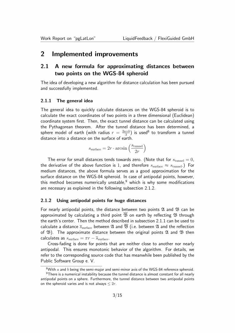
Work Report on “pgLatLon” LiquidFeedback / FlexiGuided GmbH
2 Implemented improvements
2.1 A new formula for approximating distances betweentwo points on the WGS-84 spheroid
The idea of developing a new algorithm for distance calculation has been pursuedand successfully implemented.
2.1.1 The general idea
The general idea to quickly calculate distances on the WGS-84 spheroid is tocalculate the exact coordinates of two points in a three dimensional (Euclidean)coordinate system first. Then, the exact tunnel distance can be calculated usingthe Pythagorean theorem. After the tunnel distance has been determined, asphere model of earth (with radius r = 2a+b
3) is used8 to transform a tunnel
distance into a distance on the surface of earth.
ssurface = 2r · arcsin(stunnel
2r
)The error for small distances tends towards zero. (Note that for stunnel = 0,
the derivative of the above function is 1, and therefore ssurface ≈ stunnel.) Formedium distances, the above formula serves as a good approximation for thesurface distance on the WGS-84 spheroid. In case of antipodal points, however,this method becomes numerically unstable,9 which is why some modificationsare necessary as explained in the following subsection 2.1.2.
2.1.2 Using antipodal points for huge distances
For nearly antipodal points, the distance between two points A and B can beapproximated by calculating a third point B on earth by reflecting B throughthe earth’s center. Then the method described in subsection 2.1.1 can be used tocalculate a distance ssurface between A and B (i.e. between A and the reflectionof B). The approximate distance between the original points A and B thencalculates as ssurface = πr − ssurface.
Cross-fading is done for points that are neither close to another nor nearlyantipodal. This ensures monotonic behavior of the algorithm. For details, werefer to the corresponding source code that has meanwhile been published by thePublic Software Group e. V.
8With a and b being the semi-major and semi-minor axis of the WGS-84 reference spheroid.9There is a numerical instability because the tunnel distance is almost constant for all nearly
antipodal points on a sphere. Furthermore, the tunnel distance between two antipodal pointson the spheroid varies and is not always ≤ 2r.
3/15
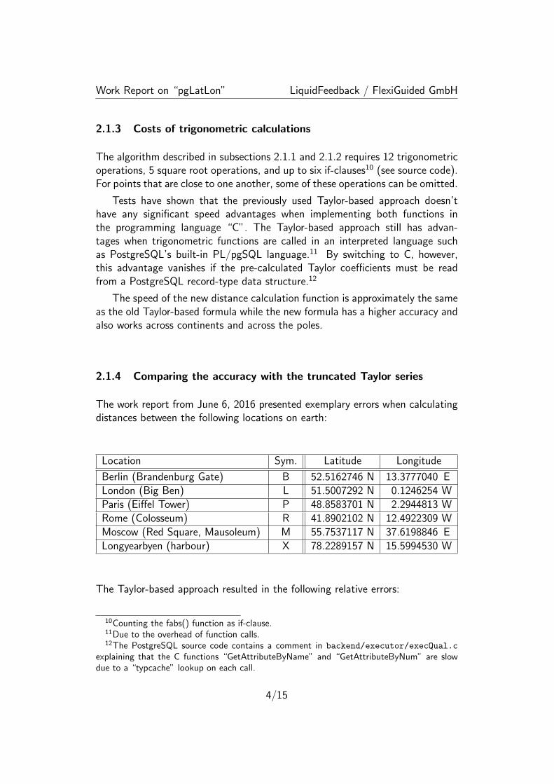
Work Report on “pgLatLon” LiquidFeedback / FlexiGuided GmbH
2.1.3 Costs of trigonometric calculations
The algorithm described in subsections 2.1.1 and 2.1.2 requires 12 trigonometricoperations, 5 square root operations, and up to six if-clauses10 (see source code).For points that are close to one another, some of these operations can be omitted.
Tests have shown that the previously used Taylor-based approach doesn’thave any significant speed advantages when implementing both functions inthe programming language “C”. The Taylor-based approach still has advan-tages when trigonometric functions are called in an interpreted language suchas PostgreSQL’s built-in PL/pgSQL language.11 By switching to C, however,this advantage vanishes if the pre-calculated Taylor coefficients must be readfrom a PostgreSQL record-type data structure.12
The speed of the new distance calculation function is approximately the sameas the old Taylor-based formula while the new formula has a higher accuracy andalso works across continents and across the poles.
2.1.4 Comparing the accuracy with the truncated Taylor series
The work report from June 6, 2016 presented exemplary errors when calculatingdistances between the following locations on earth:
Location Sym. Latitude Longitude
Berlin (Brandenburg Gate) B 52.5162746 N 13.3777040 ELondon (Big Ben) L 51.5007292 N 0.1246254 WParis (Eiffel Tower) P 48.8583701 N 2.2944813 WRome (Colosseum) R 41.8902102 N 12.4922309 WMoscow (Red Square, Mausoleum) M 55.7537117 N 37.6198846 ELongyearbyen (harbour) X 78.2289157 N 15.5994530 W
The Taylor-based approach resulted in the following relative errors:
10Counting the fabs() function as if-clause.11Due to the overhead of function calls.12The PostgreSQL source code contains a comment in backend/executor/execQual.c
explaining that the C functions “GetAttributeByName” and “GetAttributeByNum” are slowdue to a “typcache” lookup on each call.
4/15
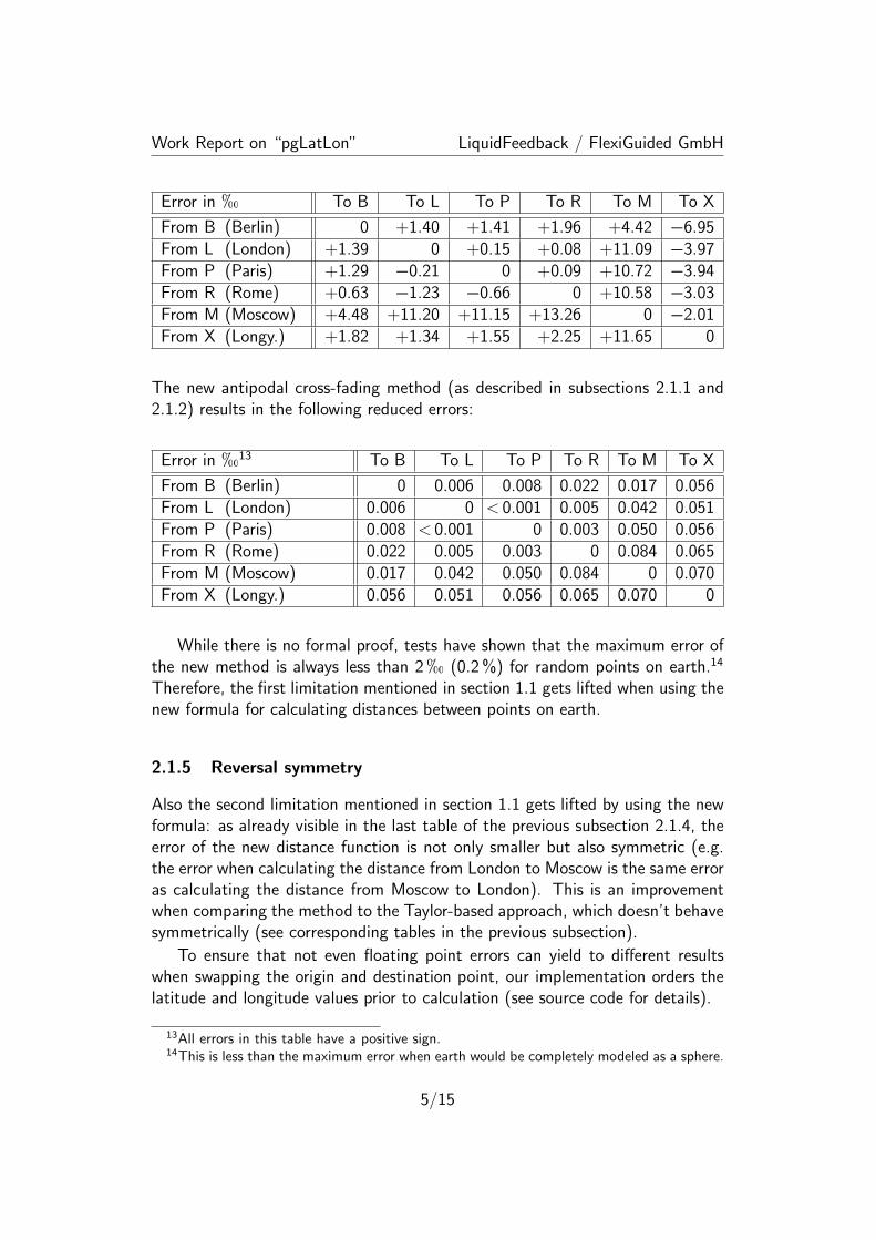
Work Report on “pgLatLon” LiquidFeedback / FlexiGuided GmbH
Error in h To B To L To P To R To M To X
From B (Berlin) 0 +1.40 +1.41 +1.96 +4.42 −6.95From L (London) +1.39 0 +0.15 +0.08 +11.09 −3.97From P (Paris) +1.29 −0.21 0 +0.09 +10.72 −3.94From R (Rome) +0.63 −1.23 −0.66 0 +10.58 −3.03From M (Moscow) +4.48 +11.20 +11.15 +13.26 0 −2.01From X (Longy.) +1.82 +1.34 +1.55 +2.25 +11.65 0
The new antipodal cross-fading method (as described in subsections 2.1.1 and2.1.2) results in the following reduced errors:
Error in h13 To B To L To P To R To M To X
From B (Berlin) 0 0.006 0.008 0.022 0.017 0.056From L (London) 0.006 0 < 0.001 0.005 0.042 0.051From P (Paris) 0.008 < 0.001 0 0.003 0.050 0.056From R (Rome) 0.022 0.005 0.003 0 0.084 0.065From M (Moscow) 0.017 0.042 0.050 0.084 0 0.070From X (Longy.) 0.056 0.051 0.056 0.065 0.070 0
While there is no formal proof, tests have shown that the maximum error ofthe new method is always less than 2h (0.2%) for random points on earth.14
Therefore, the first limitation mentioned in section 1.1 gets lifted when using thenew formula for calculating distances between points on earth.
2.1.5 Reversal symmetry
Also the second limitation mentioned in section 1.1 gets lifted by using the newformula: as already visible in the last table of the previous subsection 2.1.4, theerror of the new distance function is not only smaller but also symmetric (e.g.the error when calculating the distance from London to Moscow is the same erroras calculating the distance from Moscow to London). This is an improvementwhen comparing the method to the Taylor-based approach, which doesn’t behavesymmetrically (see corresponding tables in the previous subsection).
To ensure that not even floating point errors can yield to different resultswhen swapping the origin and destination point, our implementation orders thelatitude and longitude values prior to calculation (see source code for details).
13All errors in this table have a positive sign.14This is less than the maximum error when earth would be completely modeled as a sphere.
5/15

Work Report on “pgLatLon” LiquidFeedback / FlexiGuided GmbH
2.2 Utilizing PostgreSQL’s Generalized Search Tree (GiST)framework
While the improvements described in section 2.1 can lift the first and secondlimitation mentioned in section 1.1, a mere formula for calculating distancescannot improve the syntax constraints (third issue) or allow nearest neighborsearches without the incremental workaround (fourth issue in secion 1.1).
For these reasons, we considered using the GiST interface of PostgreSQL toprovide an integrated solution for geospatial indexing.15
2.2.1 A short introduction to GiST
For the remainder of this section 2.2, we assert that the reader be familiar withthe general strucuture of GiST indices. A short introduction to GiST can befound at the following URLs:
• http://gist.cs.berkeley.edu/
• http://db.cs.berkeley.edu/papers/vldb95-gist.pdf
• https://www.postgresql.org/docs/9.5/static/gist-intro.html
An implementation of a nearest neighbor search capable GiST index in Post-greSQL requires the implementation of the following 8 support functions: “con-sistent”, “union”, “compress”, “decompress”, “penalty”, “picksplit”, “same”,“distance”.16 The structure of the index differs depending on the particularimplementations chosen for these functions.
After discussing the key structure for keys stored in the index (based on aspace-filling fractal curve) in subsection 2.2.2, a short overview on the partic-ular implementation of each of the 8 GiST support functions will be given insubsection 2.2.3.
2.2.2 Using a space-filling curve
While both PostgreSQL and PostGIS use GiST-based R-tree indices for geometric(and, in case of PostGIS, geographical) data types, an R-tree based implemen-tation didn’t appear to be the best choice for geospatial indexing.17 Instead, we
15This was already proposed in section 3.3 (“Remaining tasks”) of work report June 6, 2016as well as footnote 45 on page 16 of the same document.
16https://www.postgresql.org/docs/9.5/static/gist-extensibility.html17An R-tree usually has overlapping nodes and requires to store bounding boxes for each
node. For these two reasons, additional working memory would be consumed which, in turn,can be a problem for caching indices on huge datasets in main memory.
6/15
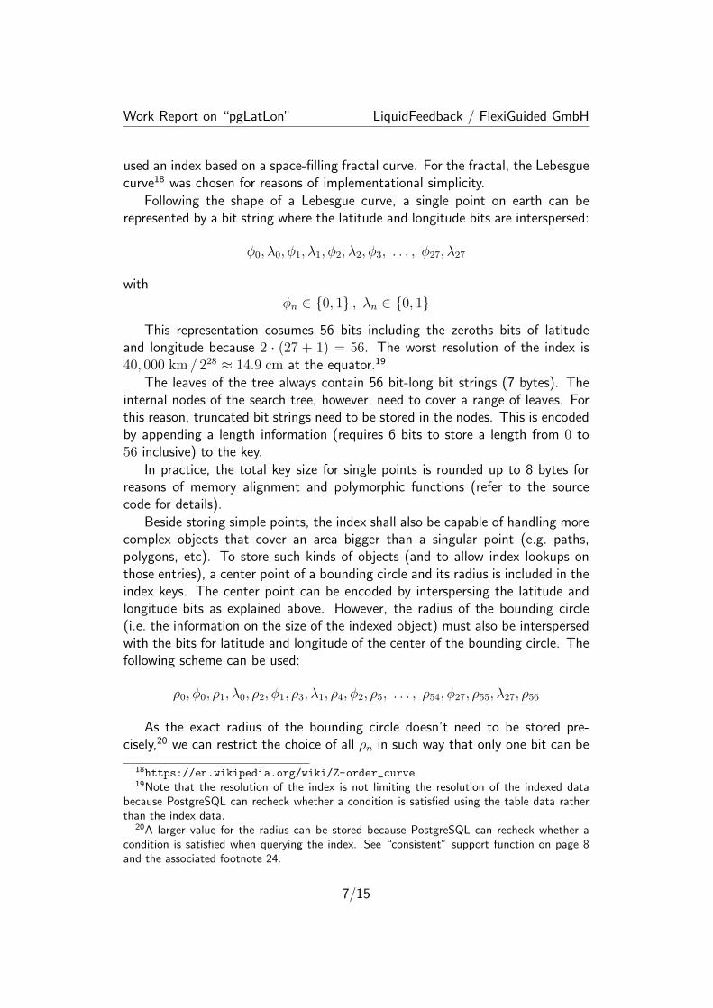
Work Report on “pgLatLon” LiquidFeedback / FlexiGuided GmbH
used an index based on a space-filling fractal curve. For the fractal, the Lebesguecurve18 was chosen for reasons of implementational simplicity.
Following the shape of a Lebesgue curve, a single point on earth can berepresented by a bit string where the latitude and longitude bits are interspersed:
ϕ0, λ0, ϕ1, λ1, ϕ2, λ2, ϕ3, . . . , ϕ27, λ27
with
ϕn ∈ {0, 1} , λn ∈ {0, 1}
This representation cosumes 56 bits including the zeroths bits of latitudeand longitude because 2 · (27 + 1) = 56. The worst resolution of the index is40, 000 km / 228 ≈ 14.9 cm at the equator.19
The leaves of the tree always contain 56 bit-long bit strings (7 bytes). Theinternal nodes of the search tree, however, need to cover a range of leaves. Forthis reason, truncated bit strings need to be stored in the nodes. This is encodedby appending a length information (requires 6 bits to store a length from 0 to56 inclusive) to the key.
In practice, the total key size for single points is rounded up to 8 bytes forreasons of memory alignment and polymorphic functions (refer to the sourcecode for details).
Beside storing simple points, the index shall also be capable of handling morecomplex objects that cover an area bigger than a singular point (e.g. paths,polygons, etc). To store such kinds of objects (and to allow index lookups onthose entries), a center point of a bounding circle and its radius is included in theindex keys. The center point can be encoded by interspersing the latitude andlongitude bits as explained above. However, the radius of the bounding circle(i.e. the information on the size of the indexed object) must also be interspersedwith the bits for latitude and longitude of the center of the bounding circle. Thefollowing scheme can be used:
ρ0, ϕ0, ρ1, λ0, ρ2, ϕ1, ρ3, λ1, ρ4, ϕ2, ρ5, . . . , ρ54, ϕ27, ρ55, λ27, ρ56
As the exact radius of the bounding circle doesn’t need to be stored pre-cisely,20 we can restrict the choice of all ρn in such way that only one bit can be
18https://en.wikipedia.org/wiki/Z-order_curve19Note that the resolution of the index is not limiting the resolution of the indexed data
because PostgreSQL can recheck whether a condition is satisfied using the table data ratherthan the index data.
20A larger value for the radius can be stored because PostgreSQL can recheck whether acondition is satisfied when querying the index. See “consistent” support function on page 8and the associated footnote 24.
7/15
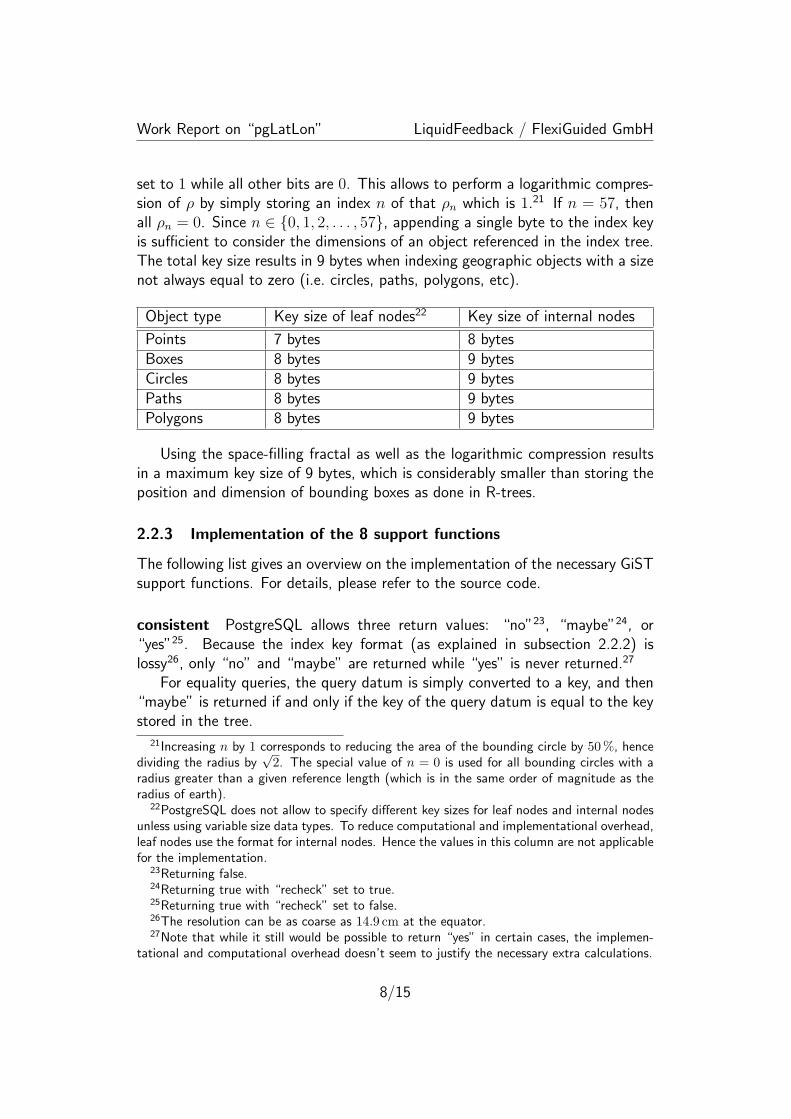
Work Report on “pgLatLon” LiquidFeedback / FlexiGuided GmbH
set to 1 while all other bits are 0. This allows to perform a logarithmic compres-sion of ρ by simply storing an index n of that ρn which is 1.21 If n = 57, thenall ρn = 0. Since n ∈ {0, 1, 2, . . . , 57}, appending a single byte to the index keyis sufficient to consider the dimensions of an object referenced in the index tree.The total key size results in 9 bytes when indexing geographic objects with a sizenot always equal to zero (i.e. circles, paths, polygons, etc).
Object type Key size of leaf nodes22 Key size of internal nodes
Points 7 bytes 8 bytesBoxes 8 bytes 9 bytesCircles 8 bytes 9 bytesPaths 8 bytes 9 bytesPolygons 8 bytes 9 bytes
Using the space-filling fractal as well as the logarithmic compression resultsin a maximum key size of 9 bytes, which is considerably smaller than storing theposition and dimension of bounding boxes as done in R-trees.
2.2.3 Implementation of the 8 support functions
The following list gives an overview on the implementation of the necessary GiSTsupport functions. For details, please refer to the source code.
consistent PostgreSQL allows three return values: “no”23, “maybe”24, or“yes”25. Because the index key format (as explained in subsection 2.2.2) islossy26, only “no” and “maybe” are returned while “yes” is never returned.27
For equality queries, the query datum is simply converted to a key, and then“maybe” is returned if and only if the key of the query datum is equal to the keystored in the tree.
21Increasing n by 1 corresponds to reducing the area of the bounding circle by 50%, hencedividing the radius by
√2. The special value of n = 0 is used for all bounding circles with a
radius greater than a given reference length (which is in the same order of magnitude as theradius of earth).
22PostgreSQL does not allow to specify different key sizes for leaf nodes and internal nodesunless using variable size data types. To reduce computational and implementational overhead,leaf nodes use the format for internal nodes. Hence the values in this column are not applicablefor the implementation.
23Returning false.24Returning true with “recheck” set to true.25Returning true with “recheck” set to false.26The resolution can be as coarse as 14.9 cm at the equator.27Note that while it still would be possible to return “yes” in certain cases, the implemen-
tational and computational overhead doesn’t seem to justify the necessary extra calculations.
8/15
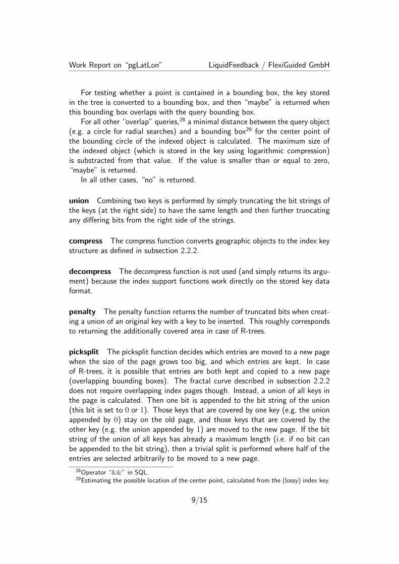
Work Report on “pgLatLon” LiquidFeedback / FlexiGuided GmbH
For testing whether a point is contained in a bounding box, the key storedin the tree is converted to a bounding box, and then “maybe” is returned whenthis bounding box overlaps with the query bounding box.
For all other “overlap” queries,28 a minimal distance between the query object(e.g. a circle for radial searches) and a bounding box29 for the center point ofthe bounding circle of the indexed object is calculated. The maximum size ofthe indexed object (which is stored in the key using logarithmic compression)is substracted from that value. If the value is smaller than or equal to zero,“maybe” is returned.
In all other cases, “no” is returned.
union Combining two keys is performed by simply truncating the bit strings ofthe keys (at the right side) to have the same length and then further truncatingany differing bits from the right side of the strings.
compress The compress function converts geographic objects to the index keystructure as defined in subsection 2.2.2.
decompress The decompress function is not used (and simply returns its argu-ment) because the index support functions work directly on the stored key dataformat.
penalty The penalty function returns the number of truncated bits when creat-ing a union of an original key with a key to be inserted. This roughly correspondsto returning the additionally covered area in case of R-trees.
picksplit The picksplit function decides which entries are moved to a new pagewhen the size of the page grows too big, and which entries are kept. In caseof R-trees, it is possible that entries are both kept and copied to a new page(overlapping bounding boxes). The fractal curve described in subsection 2.2.2does not require overlapping index pages though. Instead, a union of all keys inthe page is calculated. Then one bit is appended to the bit string of the union(this bit is set to 0 or 1). Those keys that are covered by one key (e.g. the unionappended by 0) stay on the old page, and those keys that are covered by theother key (e.g. the union appended by 1) are moved to the new page. If the bitstring of the union of all keys has already a maximum length (i.e. if no bit canbe appended to the bit string), then a trivial split is performed where half of theentries are selected arbitrarily to be moved to a new page.
28Operator “&&” in SQL.29Estimating the possible location of the center point, calculated from the (lossy) index key.
9/15
Work Report on “pgLatLon” LiquidFeedback / FlexiGuided GmbH
same The “same” support function simply tests two keys for equality. In ourimplementation, this check can be performed binary (using memcmp) becauseall unused bits are always initialized.
distance The distance function returns a minimal distance between the queryobject and the bounding box29 of the center point of the bounding circle ofthe indexed object. Then the maximum size of the indexed object (which isstored using logarithmic compression) is substracted. (This is basically the samemechanism described for the “consistent” function.)
The result is sanitized in such way that only zero or positive finite values arereturned because PostgreSQL internally uses −∞ and +∞ for other purposes,such as handling NULL values.30
2.2.4 Handling empty objects
Special considerations have been taken to handle empty objects in the index(objects which do not contain any point and thus do not overlap with any othergeographic object or even themselves). These could be circles with a negativeradius or a set of polygons that is empty.
In order to process empty objects (which are distrinct from NULL), the “com-press” function must return a special key (the “empty key”) that is not matchingany location on earth. Furthermore, another special key (the “universal key”)covering both empty and non-empty geographic objects must be returned by the“union” function when combining keys of empty and non-empty objects.
The two special keys “empty key” and “universal key” are implemented with-out additional space consumption by storing a magic value in the byte that isnormally storing the logarithmically compressed object size. For the details ofthe implementation, refer to the source code.
2.3 Adding new data types and necessary operators
In addition to providing the previously explained key format and associated GiSTsupport functions, actual implementations for the desired operators had to becreated. Most importantly, that is:
• the overlap operator (&&),
• the distance operator (<->).
For most other operators such as the “contains” (@>)31 and the “contained in”
30https://www.postgresql.org/docs/9.5/static/gist-extensibility.html
warns about returning ±∞.31In older PostgreSQL versions: ~ (still used by PostGIS).
10/15
Work Report on “pgLatLon” LiquidFeedback / FlexiGuided GmbH
(<@)32 operator, the same index strategy as used for the overlap operator (&&) canbe applied.33 Only the operator functions (and necessary geometric operations)would need to be implemented for adding these operators.
The following data types have been implemented:
• epoint: a point on earth,
• ebox: a latitude/longitude range (e.g. describing a viewport for a map),
• ecircle: a filled circle (used in conjunction with the distance operator forradial searches with fixed radius),
• ecluster: a collection of points, paths, (filled) polygons, and outlines(i.e. closed paths / non-filled polygons).
Particularly for polygons, certain geometric algorithms had to be implementedsuch as a “point in polygon” algorithm based on ray tracing34 or geometric pro-jections to determine the shortest distance between two polygons or a pointand a polygon. As a result, the distance operator <-> works with high preci-sion and does not use bounding boxes for an approximation of the distance toclusters/polygons. (Note: PostGIS, in contrast, uses inaccurate bounding boxeshere.)
Currently not all combinations of operators and/or data types are imple-mented. This is ongoing work; for details refer to the published reference docu-mentation.
2.4 Treatment of the poles and the 180th meridian
The distance calculation algorithm as explained in section 2.1 works properly bothat the poles and the 180th meridian. The new algorithm automatically considersshortest paths crossing the north or south pole when calculating distances (e.g.between Iceland and Alaska). No special handling is required here.
The fractal index as explained in section 2.2 has a slight drop of performancenear the poles because of the singularity in the coordinate system (at the polesall possible longitudes from −180 to +180 degrees are covered). The accuracy,however, is not affected by the index.
Whenever clusters are used (which may contain paths, polygons, or outlinesof polygons), there is a drop in accuracy next to the poles that depends on
32In older PostgreSQL versions: @ (still used by PostGIS).33If an object is contained in another object, those two objects always overlap.34https://en.wikipedia.org/wiki/Point_in_polygon
11/15
Work Report on “pgLatLon” LiquidFeedback / FlexiGuided GmbH
the maximum distance between the vertices of the polygon. This is becauseprojections are performed in Euclidean space.
In order to avoid ambiguities in regard to eastern/western orientation of edgesof paths, polygons, or outlines of polygons, each entry in a cluster may only covera longitude range of less than 180 degrees. Areas that cover a wider longituderange are still possible by splitting them into multiple polygons.
3 Comparison with PostGIS
As PostGIS is only available under the terms of a viral license that is incompatiblewith certain other open source licenses,35 using PostGIS is not an option for theLiquidFeedback project.36 However, we will compare our created solution withPostGIS for informational reasons.
3.1 Constraints in PostGIS when treating the earth as aspheroid
PostGIS does not support global coordinates for a wide range of functions. Toname a few examples:
• The ST Overlaps function is not defined for the geographic data type.
• The <-> operator returns true distances only between values of the geom-etry data type (which doesn’t work globally) but uses “sphere distance”for the geography data type (which can describe global coordinates).
• The && operator uses bounding boxes for determining whether two ob-jects overlap (i.e. the operator may return true even if two objects do notoverlap). This is an even bigger error than just modeling earth as a sphere.
Our created extension, in contrast, always uses spheroid coordinates for alloperations.37 Distances are measured in such way that all local operations honorthe flattening of earth, even if the data type and/or table column stores globalcoordinates. Only for long-range distances, the error can grow up to 0.2%, whichis still better than modeling earth as a sphere.
35Refer to page 9 of work report June 6, 2016.36LiquidFeedback aims to provide users and developers maximum freedom and accessibility to
the source code also when combining it with any other software components. The GNU GeneralPublic License is contrary to these goals. See also: http://www.public-software-group.org/licenses
37The only exception is when internally performing projections on a polygon, path, or outlinein order to determine the shortest distance to a cluster (see section 2.4). The error, however,approaches zero in most practical cases.
12/15

Work Report on “pgLatLon” LiquidFeedback / FlexiGuided GmbH
3.2 OpenGIS “Simple Features Specification for SQL”
PostGIS provides many functions such as ST Distance, ST MakePoint, etc. asdefined in standards by the OpenGIS consortium as well as ISO 19125. Imple-menting these functions as well as data storage formats that follow the OpenGISgeometry class hierarchy is possible but a matter of time and resources (see alsofollowing section 4.2 on compatibility considerations regarding additional datastorage formats). It should be noted that PostGIS does not properly implementmany of the functions when using spheroid coordinates that work across sev-eral continents, i.e. globally. This has already been elaborated in the previoussubsection 3.1.
4 Compatibility considerations
4.1 Standard compliance
GIS standards may be followed on the SQL level or on the level of data repre-sentation when querying a database through REST API calls.
As already mentioned in section 3.2, extending our geospatial extension forPostgreSQL to include functions such as ST Distance, ST MakePoint, and as-sociated data types on the SQL level is possible but a matter of time and resources(and budget).
Beside these economic concerns, it is currently not planned in the WeGovNowconsortium to provide any form of SQL interface to third party components.Instead, a REST based API has been proposed (and is already implemented byGeoKey, for example). Therefore, compatibility must be ensured on the levelof data representation when querying WeGovNow software components throughREST API calls.
As we will see in the following section 4.2 on additional data storage formats,PostgreSQL enables a programmer to include any desirable data format withlittle overhead. Therefore, it is easily possible to make a REST API interfacestandard compliant with any kind of geospatial data exchange format includingthose which follow the OpenGIS geometry class hierarchy or any other schemelike GeoJSON (which is used by UCL’s GeoKey).
4.2 Additional data storage formats
It is desirable to also support more complex geographic data formats such asGeoJSON or XML based documents, which may contain meta data. Whenever
13/15
Work Report on “pgLatLon” LiquidFeedback / FlexiGuided GmbH
needed, these formats can be stored directly in a corresponding JSONB, XML38,or even TEXT table column.39 All spatial indexing functions and operators aspresented in section 2 of this paper, may still be used for these data formats evenif the data types do not support lossless round-trip conversions. This is possiblebecause PostgreSQL supports indexes on expressions (see chapter 11.7 of thePostgreSQL 9.5 manual40). An application simply needs to provide a one-waymapping function from the stored geographic data type to one of the data typessupported by the index.
4.3 Using a different spheroid
Also other reference spheroids than WGS-84 are thinkable by adjusting the corre-sponding constants in the C code. However, as the WeGovNow project dependson a compatible standard for coordinates anyway, it would be advisable to useWGS-84 as a common standard.
5 Publication of results
The developed software has been submitted to the Public Software Group e. V onAugust 18, 2016 and was published by the Public Software Group in the sourcecode repository of LiquidFeedback Core41 under the terms of the MIT-License42
on August 18, 2016.
The source code has been modularized so that it is easy for other consortiumpartners to incorporate it, if desired. All previous work on LiquidFeedback inregard to spatial data was adjusted in order to use the new geospatial indexingmodule.
38Support for the XML data type requires PostgreSQL to be compiled with the“--with-libxml” configuration option.
39Such data types may be extended by adding validity checks using so-called “domains”.See PostgreSQL’s documentation on the CREATE DOMAIN command: https://www.
postgresql.org/docs/9.5/static/sql-createdomain.html.40https://www.postgresql.org/docs/9.5/static/indexes-expressional.html41http://www.public-software-group.org/mercurial/liquid_feedback_core/
rev/96ee2db56bec42http://www.public-software-group.org/mercurial/liquid_feedback_core/
file/96ee2db56bec/LICENSE
14/15
Work Report on “pgLatLon” LiquidFeedback / FlexiGuided GmbH
6 Conclusion & Outlook
It has been shown that PostGIS’ spatial indexing functions can be replaced bya more lightweight approach within reasonable time. Previous limitations (seesection 1.1) could be lifted. A usable implementation has been published as opensource software under a permissive (non-viral) license.
While certain data representation formats are not yet supported by the newextension, these could easily be integrated with the current implementation (referto section 4 for that matter).43
© 2016 FlexiGuided GmbH, Berlin
43Note, however, that other data structures (such as bezier curves etc.) would require furtherdata type implementations.
15/15
Recommended