CRUISE REPORT
FOR
MMS CRUISE CAMP 1-3, LEG 4
MMS CRUISE CAMP 2-1, 2-2
CALIFORNIA OCS PHASE II MONITORING PROGRAM
AUGUST 21, 1987
Performed for
U. S. Department of the Interior MINERALS MANAGEMENT SERVICE
Pacific OCS Office
1340 West Sixth Street Los Angeles, California 90017
by
Mr. James F. Campbell BATTELLE OCEAN SCIENCES
Ventura Operations 1431 Spinnaker Drive
Ventura, California, 93001
Mr. Dane Hardin KINNETIC LABORATORIES, INCORPORATED . Santa Cruz, California 95061
Dr. David Cacchione UNITED STATES GEOLOGICAL SURVEY
Menlo Park, CA 94025

TABLE OF CONTENTS
Page
1.0 INTRODUCTION 1
Z.O CRUISE REPORT, MMS CRUISE CAMP 1-3, 1EG 4 y' v,
2.1 Objectives 2
2.2 Cruise Participants 2
2.3 Activities 2
3.0 CRUISE REPORT, MMS CRUISE CAMP 2-1
3.1 Introduction 6
3.2 Objectives 6
3.3 Results 6
3.4 Activities 8
3.5 Navigation , . . . 9
3.6 Grab Sampling 9
3.7 Cruise Participants 10
3.8 Acknowledgements 10
4.0 CRUISE REPORT, MMS CRUISE CAMP 2-2
4.1 Objectives 15
4.2 Activities 15
APPENDIX A - REPORT OF OBSERVATIONS/SAMPLES COLLECTED BY OCEANOGRAPHIC PROGRAMS (ROSCOP)
LIST OF FIGURES AND TABLE
Figure 3-1. Area of Study and Station Locations with Cruise Track Indicated for MMS California Cruise CAMP 2-1, M/V Aloha July 23-28, 1987 7
Table 3-1. Summary of Samples Collected on MMS Cruise CAMP 2-1 6
Table 3-2. Reference Coordinates for Soft-Bottom Life-History Stations . 11
Table 3.3. Summary of Sample Positions on Cruise CAMP 2-1 (M/V Aloha). . 12
i
CRUISE REPORT FOR
MMS CRUISE CAMP 1-3, LEG 4 MMS CRUISE CAMP 2-1 MMS CRUISE CAMP 2-2
1.0 INTRODUCTION
During July, 1987, there were three cruises performed for the California OCS Phase II Monitoring Program (MMS Contract No. 14-12-0001-30262). This program is designed to monitor potential environmental changes at a series of regional stations and at two arrays of site-specific stations near oil production platforms in the western Santa Barbara Channel and Santa Maria Basin region of the California OCS. Platform Hidalgo (Lease P-0450) off Point Argue!lo has been selected for hard-bottom, site-specific monitoring, and Platform Julius (Lease P-04G9) off Point Sal has been selected for soft-bottom, site-specific monitoring. Specific objectives of the program are:
1. To detect and measure potential long-term (or short-term) changes in the marine environment adjacent to oil and gas platforms; and
2. To determine whether changes observed in the marine environment during the monitoring period are caused by drilling-related activities or are a product of natural processes.
To accomplish these objectives, we are looking closely for potential biological changes and concomitant chemical or physical changes that can be linked to specific drilling events. An overall objective of the July cruises was to provide critical pre-drilling baseline data to help make these kinds of correlations and inferences.
The first cruise, CAMP 1-3, LEG 4 (Hard-Bottom Photosurveys/Search and Recovery Cruise) was the final leg of Cruise CAMP 1-3, May 1987. This cruise was per-formed to complete unfinished work which was the result of adverse weather conditions and equipment failures encountered on Cruise CAMP 1-3, LEG 3 in May, 1987. Cruise CAMP 2-1 (Soft-Bottom Life-History Cruise) was the first cruise of the second year for the California OCS Phase II Monitoring Program. The primary objective of this cruise was to collect benthic infauna samples for life-history analysis
-
. Cruise CAMP 2-2 (Sediment-Transport Instrument-Retrieval Cruise) had a primary objective to recover moored instruments (GEOPROBEs and current meters) which were deployed in the Platform Julius Study Area during May, 1987.
The Cruise Chief Scientists; Mr. Dane Hardin, Mr. James Campbell and Dr. David Cacchione have submitted reports (attached) of cruise activities.
International Underwater Contractor's M/V Aloha was the support vessel for each of the July cruises. The.cruises were scheduled as follows:
CAMP 1-3, LEG 4 Hard-Bottom Photosurveys/Search and Recovery Cruise 13-23 July, 1987
CAMP 2-1 Soft-Bottom Life-History Cruise 23-28 July, 1987
CAMP 2-2 Sediment-Transport Instrument-Retrieval Cruise 28-31 July, 1987
3.0 CRUISE PLAN MMS CRUISE CAMP 2-1
Soft-Bottom Life-History Cruise 23-28 July, 1987
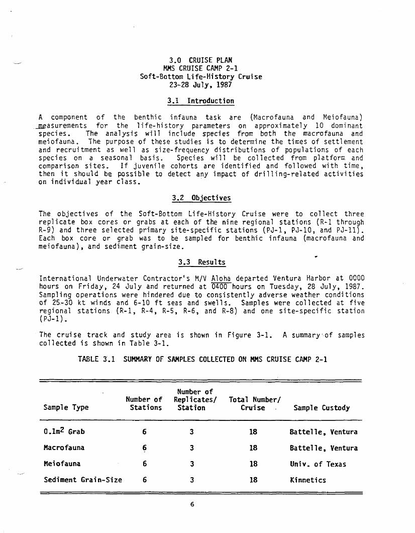
3.1 Introduction
A component of the benthic infauna task are (Macrofauna and Meiofauna) .measurements for the life-history parameters on approximately 10 dominant species. The analysis will include species from both the macrofa-una and meiofauna. The purpose of these studies is to determine the times of settlement and recruitment as well as size-frequency distributions of populations of each species on a seasonal basis. Species will be collected from platform and comparison sites. If juvenile cohorts are identified and followed with time, then it should be possible to detect any impact of drilling-related activities on individual year class.
3.2 Objectives
The objectives of the Soft-Bottom Life-History Cruise were to collect three replicate box cores or grabs at each of the nine regional stations (R-l through R-9) and three selected primary site-specific stations (PJ-1, PJ-10, and PJ-11). Each box core or grab was to be sampled for benthic infauna (macrofauna and meiofauna), and sediment grain-size.
3.3 Results
International Underwater Contractor's M/V Aloha departed Ventura Harbor at 0000 hours on Friday, 24 July and returned at 0400 hours on Tuesday, 28 July, 1987. Sampling operations were hindered due to consistently adverse weather conditions of 25.-30 kt winds and 6-10 ft seas and swells. Samples were collected at five regional stations (R-l, R-4, R-5, R-6, and R-8) and one site-specific station (PJ-1).
The cruise track and study area is shown in Figure 3-1. A summary •-of samples collected is shown in Table 3-1.
TABLE 3.1 SUMMARY OF SAMPLES COLLECTED ON MMS CRUISE CAMP 2-1
Sample Type Number of Stations
Number of Replicates/ Station
Total Number/ Crui se Sample Custody
0.1m2
Grab 6 3 18 Battel!e, Ventura
Macrofauna 6 3 18 Battelle, Ventura
Meiofauna 6 3 18 Univ. of Texas
Sediment Grain-Size 6 3 18 Kinnetics
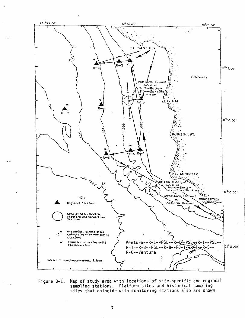
Figure 3-i. Map of study area with locations of site-specific and regional sampling stations. Platform sites and historical sampling sites that coincide with monitoring stations also are shown.
7
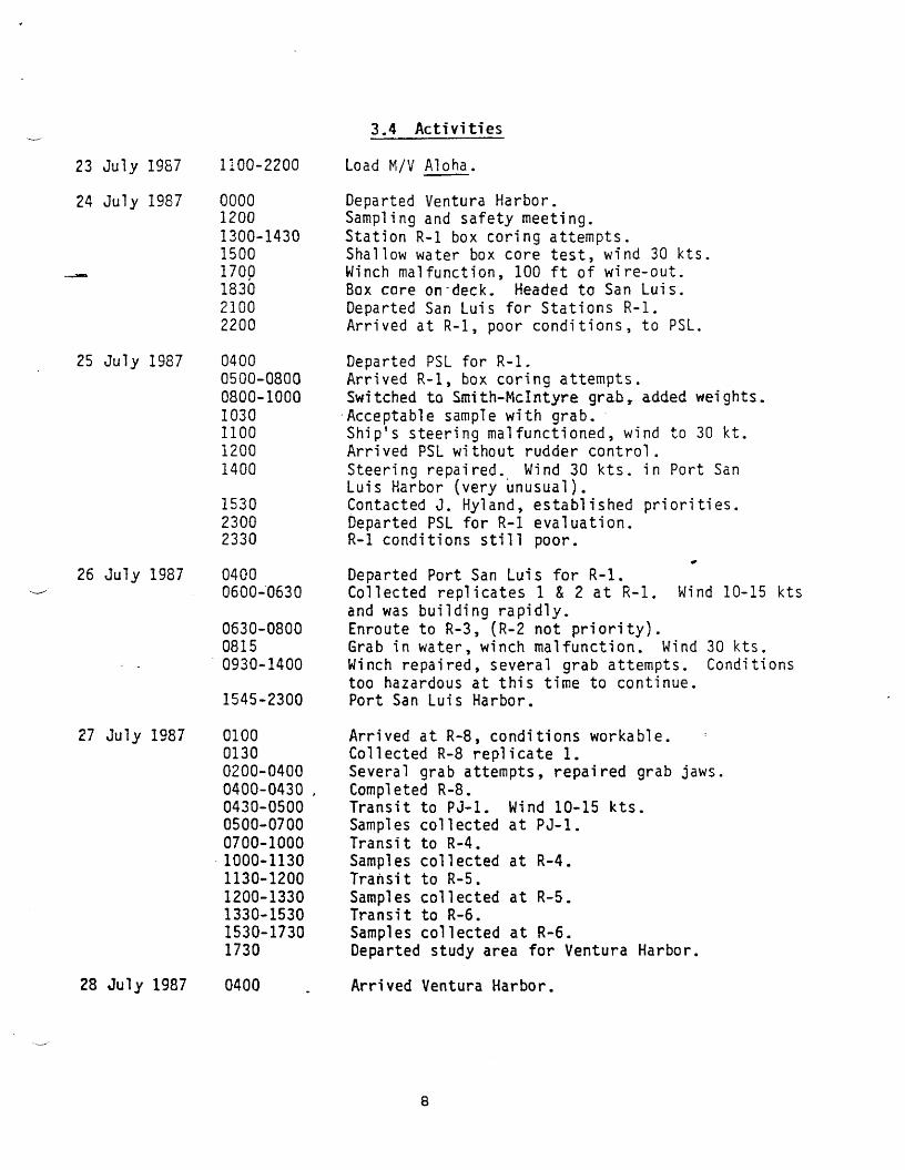
3.4 Activities
23 July 1987
24 July 1987
25 July 1987
26 July 1987
27 July 1987
1100-2200 Load M/V Aloha.
0000 Departed Ventura Harbor. 1200 Sampling and safety meeting. 1300-1430 Station R-l box coring attempts. 1500 Shallow water box core test, wind 30 kts. 1700 Winch malfunction, 100 ft of wire-out. 1830 Box core on'deck. Headed to San Luis. 2100 Departed San Luis for Stations R-l. 2200 Arrived at R-l, poor conditions, to PSL.
0400 Departed PSL for R-l. 0500-0800 Arrived R-l, box coring attempts. 0800-1000 Switched to Smith-Mclntyre grab, added weights. 1030 Acceptable sample with grab. 1100 Ship's steering malfunctioned, wind to 30 kt. 1200 Arrived PSL without rudder control. 1400 Steering repaired. Wind 30 kts. in Port San
Luis Harbor (very unusual). 1530 Contacted J. Hyland, established priorities. 2300 Departed PSL for R-l evaluation. 2330 R-l conditions still poor.
*
0400 Departed Port San Luis for R-l. 0600-0630 Collected replicates 1 & 2 at R-l. Wind 10-15 kts
and was building rapidly. 0630-0800 Enroute to R-3, (R-2 not priority). 0815 Grab in water, winch malfunction. Wind 30 kts. 0930-1400 Winch repaired, several grab attempts. Conditions
too hazardous at this time to continue. 1545-2300 Port San Luis Harbor.
0100 Arrived at R-8, conditions workable. 0130 Collected R-8 replicate 1. 0200-0400 Several grab attempts, repaired grab jaws. 0400-0430 , Completed R-8. 0430-0500 Transit to PJ-1. Wind 10-15 kts. 0500-0700 Samples collected at PJ-1. 0700-1000 Transit to R-4. 1000-1130 Samples collected at R-4. 1130-1200 Transit to R-5. 1200-1330 Samples collected at R-5. 1330-1530 Transit to R-6. 1530-1730 Samples collected at R-6. 1730 Departed study area for Ventura Harbor.
28 July 1987 0400 Arrived Ventura Harbor.
8
3.5 Navigation
The Northstar 7000 LORAN-C receiver was the primary navigational aid for Cruise CAMP 2-1. A navigation software package developed by Mr. Andy Eliason of Eliason Data Services was used to integrate an Apple lie microcomputer and Epson printer with the LORAN. The navigation data recorder logged time, date, latitude/longitude, LORAN time delays, samples collected, and general comments. The ship's position was displayed digitally on a monitor, while simultaneously recording on disk and printout. The system provided information on the ship's real-time position as well as navigation tracks to and from various waypoints.
All LORAN time delays were in the 9940 Group Repetition Interval (GRI) using the X and Y secondary stations, the 27-K and 41-K lines, respectively. All station navigation was based on LORAN time delays established in conjunction with the Mini ranger System on previous cruises. The latitude and longitude coordinates listed in this report are the products of the Northstar algorithm. The latitudes and longitudes from the Northstar are offset from geodetic coordinates and should not be used for station navigation purposes.
Station depths listed in this report are reference depths, as station depth was not recorded during this cruise.
Time was recorded in Pacific Daylight Time (PDT) during this cruise.
Station reference coordinates are listed in Table 3.2. A summary of sample positions is shown in Table 3.3.
3.6 Grab Sampling
A O.ltnZ Gray-O'Hara Box Core was intended as the primary sampling equipment for Cruise CAMP 2-1. However, due to adverse weather conditions, repeated attempts with the box core proved unsuccessful. The Smi th-McIntyre Grab was the appropriate instrument for rough sea conditions. All samples were collected using the O.lm^ Smith-McIntyre Grab.
Three replicate grabs were collected at five regional stations (R-l, R-4, R-5, R-6, and R-8) and one site-specific station (PJ-1). Each grab was first subsampled for meiofauna by inserting a single 2-cm diameter core tube into the sediment. The upper 4-cm fraction was processed and preserved. The intended meiofauna sampling method was to collect a sample to the 10-cm depth, however, since the closing action of the grab jaws tends to disturb the lower layers of the sample, Dr. Paul Montagna chose to limit the meiofauna sample depth to 4-cm in order to maintain a representative sample.
Following the collection of the meiofauna sample, two 3-cm diameter x 2-cm depth sediment plugs were removed from the grab for the purpose of sediment grain-size analysis. The remaining fraction of the sample was transferred to elutriating buckets and processed with filtered seawater through a 0.3-m mesh sieve. The residual was rinsed into 16-oz glass jars and preserved with approximately 10-percent formalin.
9
3.7 Cruise Participants
Battel!e Ocean Sciences, Ventura Operations
James Campbell Elaine Byers Janet Kennedy Valerie Eikelmann
University of Texas, Port Aransas
Dr. Paul Montagrra John Kern -Richard Kalke Eileen Lampp
3.8 Acknowledgements
Many thanks to all members of the scientific party for their perserverance and hard work resulting in a safe and senri-successful cruise. Our thanks to the crew of the M/V Aloha for keeping us on station and keeping the winch on-line.
10
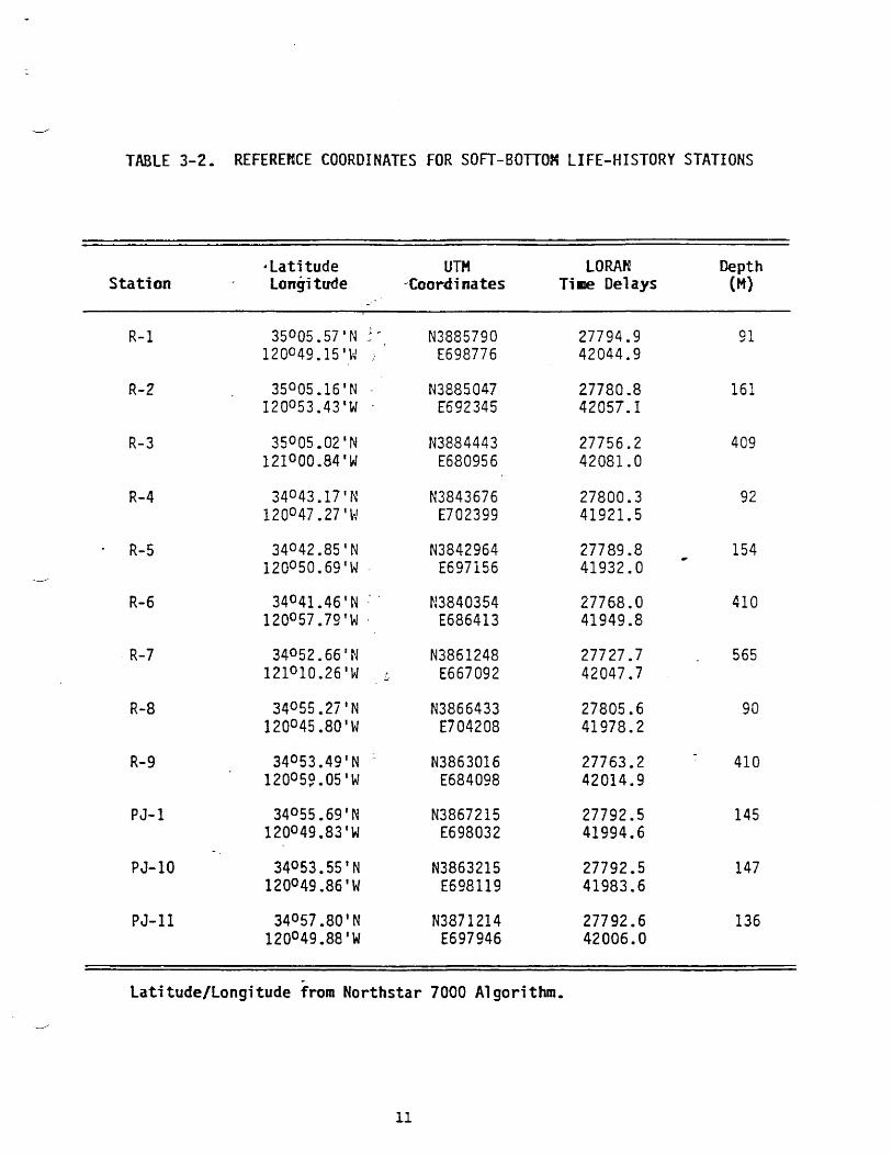
TABLE 3-2. REFERENCE COORDINATES FOR SOFT-BOTTOM LIFE-HISTORY STATIONS
'Latitude UTM LORAN Depth Station Longitude Coordinates Time Delays (M)
R-l 35°05.57 1
N N3885790 27794.9 91 120°49.15'W ) ' E698776 42044.9
R-2 35°05.16'N - N3885047 27780.8 161 120°53.43'W • E692345 42057.1
R-3 35°05.02'N N3884443 27756.2 409 12I°00.84'W E680956 42081.0
R-4 34°43.17'N N3843676 27800.3 92 120°47.27'W E702399 41921.5
• R-5 34°42.851
N N3842964 27789.8 154 120°50.69'W E697156 41932.0
R-6 34°41.461
N ' N3840354 27768.0 410 120°57.79'W • E686413 41949.8
R-7 34052.66'N N3861248 27727.7 565 121°10.26'W .
£ E667092 42047.7
R-8 34055.27'N N3866433 27805.6 90 120°45,80'W E704208 41978.2
R-9 34°53.49'N :
N3863016 27763.2 410 120059.05'W E684098 42014.9
PJ-1 34055.69'N N3867215 27792.5 145 120°49.83'W E698032 41994.6
PJ-10 34053.55'N N3863215 27792.5 147 120°49.86'W E698119 41983.6
PJ-11 34057.80'N N3871214 27792.6 136 120°49.88'W E697946 42006.0
Latitude/Longitude from Northstar 7000 Algorithm.
11
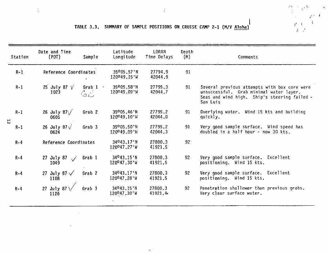
TABLE 3.3. SUMMARY OF SAMPLE POSITIONS ON.CRUISE CAMP 2-1 (M/V Aloha)
Station Date and Time
(POT) Sample Latitude Longi tude
LORAN Time Delays
Depth
(M) Comments
R-l Reference Coordinates 35°05.57 120049.15
'N 'W
27794.9 42044.9
91
R-l 25 July 87 / 1023
Grab 1 -
Co D
35°05.58 120049.09
'N •w
27795.3 42044.7
91 Several previous attempts with box core were unsuccessful. Grab minimal water layer. Seas and wind high. Ship's steering failed -San Luis
R-l
M
26 July B 7 [ / 0605
Grab 2 35°05.46 120°49.10
'N 'W
27795.2 42044.0
91 Overlying water. Wind 15 kts and building quickly.
W R-l 26 July 87 v/
0624 Grab 3 35°05.50
1
120°49.091 'N •w
27795.2 42044.3
91 Very good sample surface. Wind speed has doubled in a half hour - now 30 kts.
R-4 R e f e r e n c e Coordinates 34°43.17' 120°47.27'
'N
'W
27800.3 41921.5
92
R-4 27 July 87 y 1049
Grab 1 34°43.151
120°47.30' N W
27800.3 41921.5
92 Very good sample surface. Excellent positioning. Wind 15 kts.
R-4 27 July 87 y / 1108
/
Grab 2 34°43.171
120°47.28' N W
27800.3 41921.5
92 Very good sample surface. Excellent positioning. Wind 15 kts.
R-4 27 July 87 \ / 1126
Grab 3 34°43.15 * N 120°47.30'W
27800.3 41921.4*
92 Penetration shallower than previous grabs. Very clear surface water.
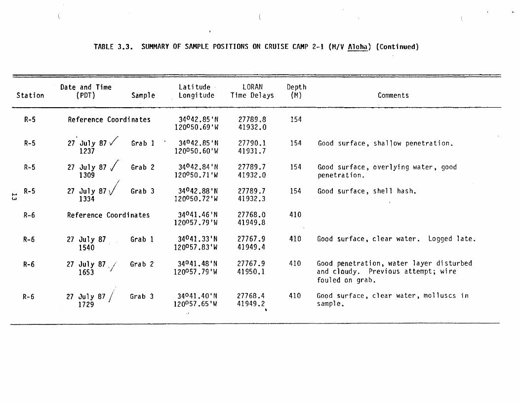
TABLE 3.3. SUMMARY OF SAMPLE POSITIONS ON CRUISE CAMP 2-1 (M/V Aloha) (Continued)
Station Date and Time
(PDT) Sample Latitude Longitude
LORAN Time Delays
Depth (M) Comments
R-5 Reference Coordinates 34°42.85'N i20°50.69'w
27789.8 41932.0
154
R-5 27 July 87 / 1237
Grab 1 34°42.85'N 120°50.60
1
W 27790.1 41931.7
154 Good surface, shallow penetration.
R-5 27 July 87 / 1309
/
Grab 2 34°42.84'N 120°50.71'W
27789.7 41932.0
154 Good surface, overlying water, good penetration.
M R
"5
tJ
27 July 8 7 / 1334
Grab 3 34°42.88'N 120°50.72'W
27789.7 41932.3
154 Good surface, shell hash.
R-6 Reference Coordinates 34°41.46'N 120°57.79' W
27768.0 41949.8
410
R-6 27 July 87 1540
Grab 1 34°41.33'N 120°57,83'W
27767.9 41949.4
410 Good surface, clear water. Logged late.
R-6 27 July 87 / 1653
7 Grab 2 34°41.48'N
120°57.79'W 27767.9 41950.1
410 Good penetration, water layer disturbed and cloudy. Previous attempt; wire fouled on grab.
R-6 27 July 87 / 1729
Grab 3 34°41.401
N 120°57.65'W
27768.4 41949.2
s
410 Good surface, clear water, molluscs in sample.
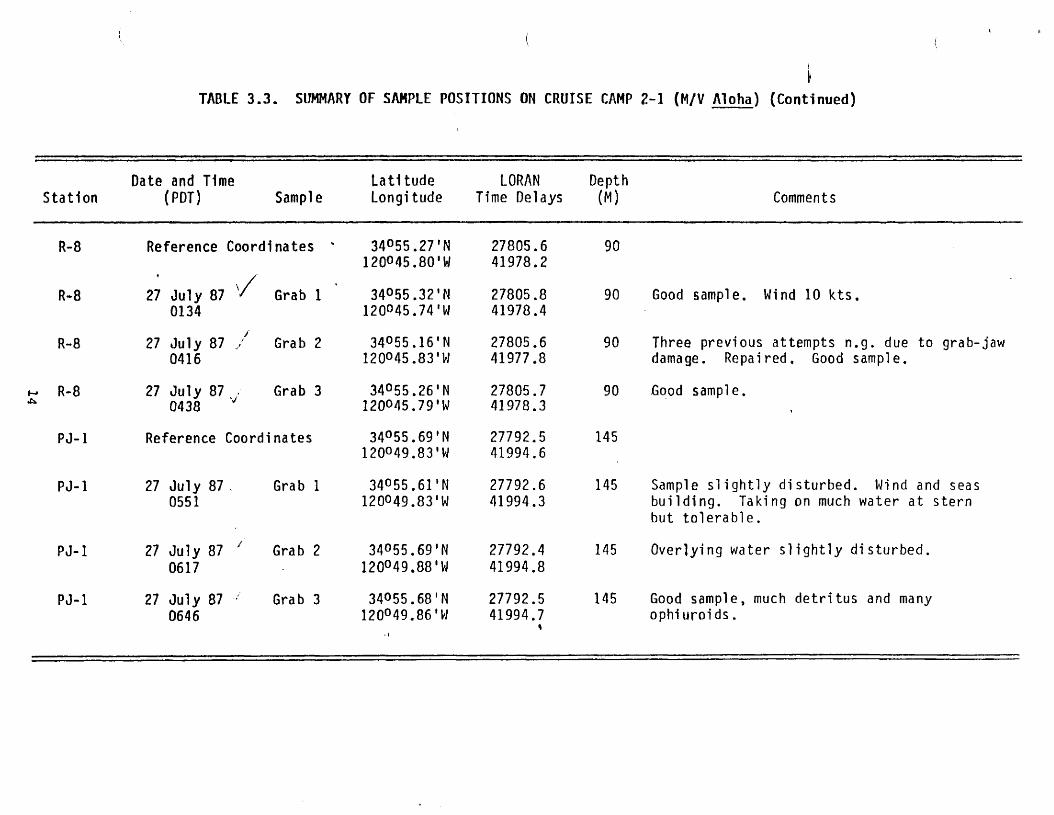
I TABLE 3.3. SUMMARY OF SAMPLE POSITIONS ON CRUISE CAMP 2-1 (M/V Aloha) (Continued)
Station Date and Time
(PDT) Sample Latitude Longitude
LORAN Time Delays
Depth (M) Comments
R-8 Reference Coordinates *
» s
34°55.27*N 120O45.80'W
27805.6 41978.2
90
R-8 27 July 87 0134
Grab 1 34055.32'N 120O45.74'W
27805.8 41978.4
90 Good sample. Wind 10 kts.
R-8 27 July 87 / 0416
Grab 2 34055.16'N 120O45.83'W
27805.6 41977.8
90 Three previous attempts n.g. due to grab-jaw damage. Repaired. Good sample.
- R-8 27 July 87 . 0438
y Grab 3 34055.26'N
120045.79'W 27805.7 41978.3
90 Good sample.
PJ-1 Reference Coordinates 34055.69'N 120049.83'W
27792.5 41994.6
145
PJ-1 27 July 87 . 0551
Grab 1 34055.61f
N 120O49.83'W
27792.6 41994.3
145 Sample slightly disturbed. Wind and seas building. Taking on much water at stern but tolerable.
PJ-1 27 July 87 7
0617
Grab 2 34055.69 'N 120°49.88'W
27792.4 41994.8
145 Overlying water slightly disturbed.
PJ-1 27 July 87 0646
Grab 3 34055.68'N 120°49.86'W
27792.5 41994.7
145 Good sample, much detritus and many ophiuroids.
M J K M ArrKUVCU; UMa MU. — C A ritxc^ : IZ—JI-/V
NOAA F O R M 2 4 - 2 3 ( 1 - 7 6 )
U. S- DEPARTMENT OF COMMERCE N A T I O N A L O C E A N I C AND A T M O S P H E R I C A D M I N I S T R A T I O N
N AXIOM A JWe! g fe ^ V A T O ^
OCEANOGRAPHY - GENERAL CRUISE INVENTORY (ROSCOP-II)
A 0 0 D A T A C E N T E R
A 4 0 R E F E R E N C E NUMSEf
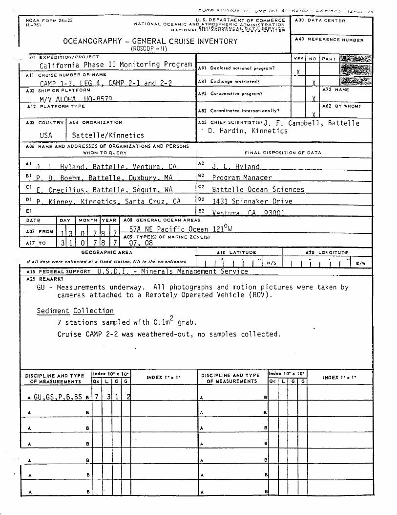
^ >01 E X P E D I T I O N / P R O J E C T California Phase II Monitoring Program
YES NO P A R T H f W ^ ^ >01 E X P E D I T I O N / P R O J E C T California Phase II Monitoring Program A91 Declared national program?
X A l l C R U I S E N U M B E R OR N A M E TAMP 1-3. 1 FG 4. CAMP 2-1 and 2-2
A91 Declared national program? X A l l C R U I S E N U M B E R OR N A M E
TAMP 1-3. 1 FG 4. CAMP 2-1 and 2-2 A81 Exchange restricted? X A02 S H I P OR P L A T F O R M
M/V Al HHA H O - ^ 7 q A92 Co-operative program?
X
A72 N A M E
A12 P L A T F O R M T Y P E A82 Ce-erdineted internat ional ly? X
A62 BY WHOM7
A03 C O U N T R Y
USA
A 04 O R G A N I Z A T I O N
BattelTe/Kinnetics
AOS CHIEF SCIENTISTS) j, p. Campbell, Battel 1 e
" D. Hardin, Kinnetics
A06 NAME AND ADDRESSES OF ORGANIZATIONS AND PERSONS WHOM TO Q U E R Y F I N A L D I S P O S I T I O N OF D A T A
A 1
,1. 1. Hvlanrl. Rat.t.pllp. Vpntura. CA A 2
J. L. Hvland B 1
P. D. Rophm. Battel!e. Duxburv. MA 9 2
Proaram Manaaer C 1
E. Crecilius. Battelle, Sequim, WA C 2
Battelle Ocean Sciences 0 1
P. Kinnpv. Kinnptirs. Santa Cruz. CA 0 2
1431 Spinnaker Drive
El E 2
Vpntura. CA 93001 DATE
A07 F R O M
AT7 T O
DAY M O N T H Y E A R
JL
AOS G E N E R A L O C E A N AREAS
B7A NE Pacific Ocean 121°W A09 TYPE(S) OF MARINE ZONE{Sl 07, 08
GEOGRAPHIC AREA If all date were collected at a fixed station, f i l l in the co-ordinates
A10 L A T I T U D E
N / S
A10 L O N G I T U D E
E /W A I 5 F E D E R A L S U P P O R T U.S.D.I. - Minerals Management Service A25 REMARKS
GU - Measurements underway. All photographs and motion pictures were taken by cameras attached to a Remotely Operated Vehicle (ROV).
Sediment Collection 2
7 stations sampled with 0.1m grab.
Cruise CAMP 2-2 was weathered-out, no samples collected.
DISCIPLINE AND TYPE Inde x 10* x 10' INDEX l ' x l * DISCIPLINE AND TYPE Index 10* x 10* I NDEX R x R OF MEASUREMENTS Qc L G G INDEX l ' x l * OF MEASUREMENTS Qc L G G I NDEX R x R
A GU,GS,P,B,BS B 7 3 1 2 A B
A B A B
A B A B
A B -
A B
A B A B
A B A B
A B A B
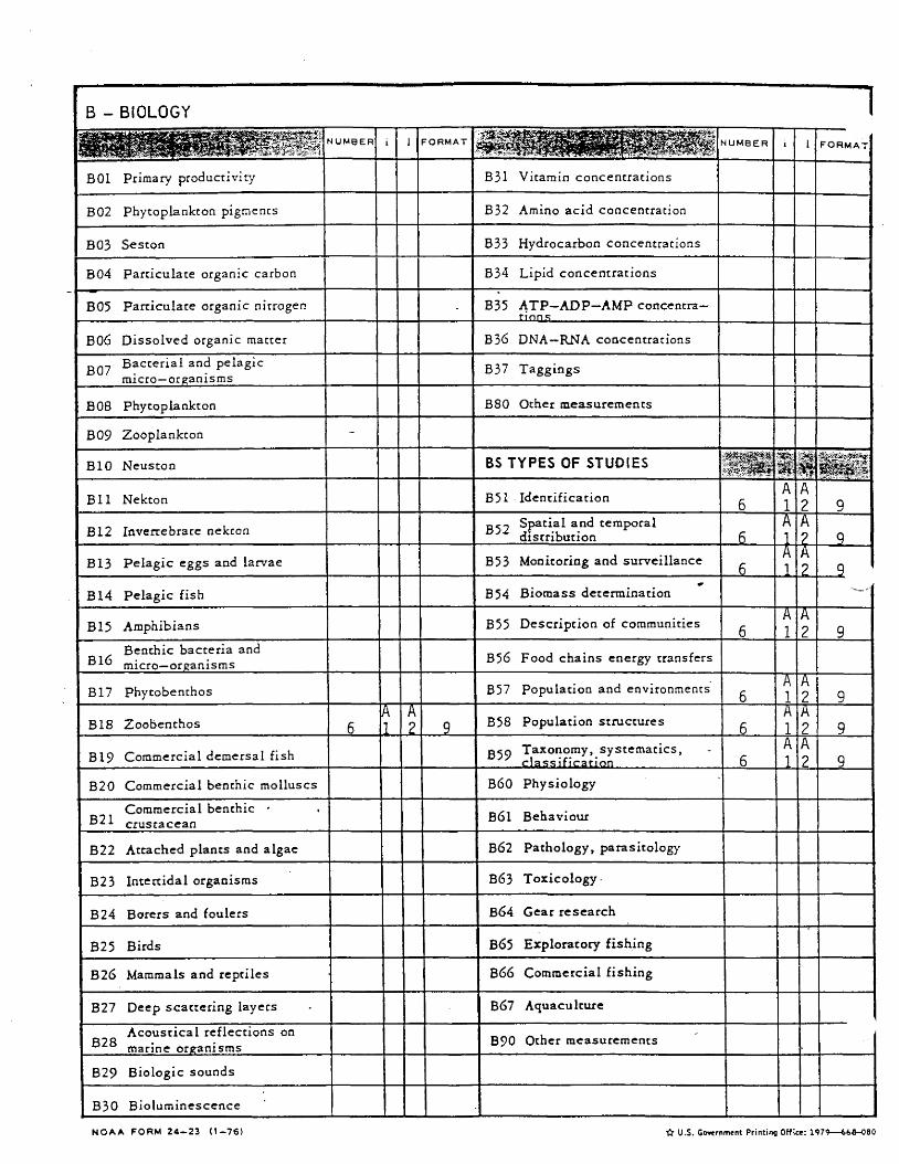
B - BIOLOGY 1
N U M B E R i i F O R M A T D U M B E R T 1 F O R M A T
B01 Primary productivity B31 Vitamin concentrations
B02 Phytoplankton pigmencs B32 Amino acid concentration
B03 Seston B33 Hydrocarbon concentrations
B04 Particulate organic carbon B34 Lipid concentrations
B05 Particulate organic nitrogen - B35 ATP—ADP—AMP concentre-H O N S
B06 Dissolved organic matter B36 DNA—RNA concentrations
gg^ Bacterial and pelagic micro—organisms
B37 Taggings
B08 Phytoplankton B80 Other measurements
B09 Zooplankton -
BIO Neuston BS TYPES OF STUDIES
B l l Nekton B51 Identification 6
A
1 A
2 9
B12 Invenebrace nekton Spatial and temporal distribution 6
A
1 A
2 9
B13 Pelagic eggs and larvae B53 Monitoring and surveillance A
1 A ?
9
B14 Pelagic fish *
B54 Biomass determination
B15 Amphibians B55 Description of communities 6
A
1 A
2 9
Benthic bacteria and micro—organisms B56 Food chains energy transfers
B17 Phytobenthos B57 Population and environments 6
A
1 A
2 9
B18 Zoobenthos 6
A
1
A
2 9 B58 Population structures
6
A
1 A
2 9
B19 Commercial demersal fish 059 Taxonomy, systematics,
classification 6
A
I
A
2 9
B20 Commercial benthic molluscs B60 Physiology
Commercial benthic • B21 crustacean B6l Behaviour
B22 Attached plants and algae B62 Pathology, parasitology
B23 Intertidal organisms B63 Toxicology
B24 Borers and foulers B64 Gear research
B25 Birds B(55 Exploratory fishing
B26 Mammals and reptiles B66 Commercial fishing
B27 Deep scattering layers B67 Aquaculcure
Acoustical reflections on B28
marine organisms B90 Other measurements
B29 Biologic sounds
B30 Bioluminescence
N O A A F O R M 2 4 - 2 3 ( 1 - 7 6 ) •(l U.S. Government Printing Office: 1"979—6i8-060
G - GEOLOGY GEOPHYSICS G - GEOLOGY GEOPHYSICS (Commued)
GS TYPES OF STUDIES N U M B E R I 1 F O R M A T
GL MEASUREMENTS MADE AT
A SPECIFIC LOCATION N U M B E R i i - O R M A T
Physical analysis of sediments 7
0
1
A 2 9
GL MEASUREMENTS MADE AT
A SPECIFIC LOCATION N U M B E R i i
G32 Chemical analysis of sediments G01 Dredge
G32 Chemical analysis of sediments G01 Dredge
G33 Paleothermy G02 Grab
G33 Paleothermy G02 Grab
G34 P a l e o m a £ n e t ^ s r n an<^ rock magnetism G03 Core rock (no. of caresj
G34 P a l e o m a £ n e t ^ s r n an<^ rock magnetism G03 Core rock (no. of caresj
G35 Paleontology G04 Core—soft bottom (no. of cores;
G35 Paleontology G04 Core—soft bottom (no. of cores;
G36 Geothermy G05 Sampling by divers
G36 Geothermy G05 Sampling by divers
G37 GeochronoLogv G06 Sampling by submersible -
G37 GeochronoLogv G06 Sampling by submersible
G38 Mineral and fossil resources G07 Drilling
G38 Mineral and fossil resources G07 Drilling
G39 Licteral zone studies G08 Bottom photography
G39 Licteral zone studies G08 Bottom photography
G90 Other measurements Sea floor temperature (< 7 m from bottomj
G90 Other measurements Sea floor temperature (< 7 m from bottomj
D - DYNAMICS Accoustical properties of the sea floor
D - DYNAMICS
Engineering properties of G i l the sea floor
Current meters D01 (no. of stat.)
Magnetic properties of the G12 s e a floor
Current meters (Average D02 duration of measurement days)
Gravimetric properties of th e S € a floor
Currents measured from D 0 3 ship drift
G14 Radioactivity measurements D04 GEK
G70 Other measurements DOS Drifters (number)
D06 Swallow floats (number)
D07 Drift cards (no. released)
GU MEASUREMENTS UNDERWAY _ * v-
v.,
~ a
1 ;<1f. * t
D08 Bottom drifters (no. released) GU MEASUREMENTS UNDERWAY _ * v-
v.,
~ a
1 ;<1f. * t
D09 Tidal observation (duration) Motion picture of sea floor (No. of nautical miles) -j ^ 9
D
1
A 1 A
D09 Tidal observation (duration) Motion picture of sea floor (No. of nautical miles) -j ^ 9
D
1
A 1 A _ Sea and swell
(no. of observations) Bathymetry-wide beam fno. of nautical miles)
_ Sea and swell (no. of observations) Bathymetry-wide beam
fno. of nautical miles)
D90 Other measurements Bathymetry-narrow beam (no. of nautical miles)
D90 Other measurements Bathymetry-narrow beam (no. of nautical miles) Side scan sonor
G24 (no. of nautical miles) Side scan sonor
G24 (no. of nautical miles)
M - METEOROLOGY. Q25 Seismic reflection (no. of nautical miles) M - METEOROLOGY.
G26 Seismic refraction (no. of nautical miles) MQ1 Upper air observations
G27 Gravimetry M02 Incident radiation
G28 Magnetism M03 Air—sea interface studies
G29 Other measurements M04 Ice observations
Bottom Photographs 9
0
1
A ? 8
Occasional standard measurements
u fw Systematic standard M measurements
M90 Other measurements
H - HYDROGRAPHY
HS SURFACE NUMBER i F O R M A T HC CHEMICAL N U M B E R i i F O R M A T
Continuous temperature recording
H26 Silicates
H02 Continuous salinity recording H27 Alkalinity
Discrete temperature H03 measurements H28 pH
Discrete salinity H04 measurements H29 Chlorinity
NEAR SEA FLOOR ( < 10 nr) «* " -ITi ** ' C H30 Trace elemencs
Continuous temperature H05 recording H31 Radioactivity
H06 Continuous salinity recording H32 Isotopes
Discrete temperature measurements
H33 Dissolved gases
Discrete salinity H08 measurements
K90 Other measurements
HP PHYSICAL "V. »
H 0 C ) Classical oceanographic stations
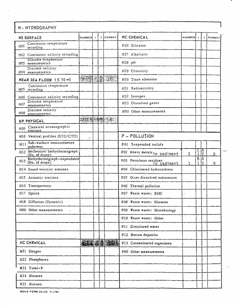
H10 Vertical profiles (STD/CTD) P - POLLUTION PU j Sub—surface measurements
underway P01 Suspended solids
HI2 Mechanical bathythermograph (No. of drops)
P02 Heavy metals i n s e d i m e n t 1 c 1
A 2 9
u , Bathythermograph—expendable (No. of drops)
P03 Petroleum residues i n sediment 1
B 1 ro
>
9 HI4 Sound velocity stations P04 Chlorinated hydrocarbons
H15 Acoustic stations P05 Otiier dissolved substances
H16 Transparency P06 Thermal pollution
H17 Optics P07 Waste water; BOD -
H18 Diffusion (Dynamic) P08 Waste water: Nitrates
H80 Other measurements P09 Waste water: Microbiology
P10 Waste water: Other
P l l Discolored water
PI2 Bottom deposits
HC CHEMICAL ISPsl
i t m
M m m b i P13 Contaminated organisms
H21 Oxygen P90 Other measurements
H22 Phosphates
H23 Total—P
H24 Nitrates
H25 Nitrites
N O A A F O R M 2 4 - 2 3 ( 1 - 7 6 )
CRUISE REPORT
FOR
MMS CRUISE CAMP 1-3, LEG 4
MMS CRUISE CAMP 2-1, 2-2
CALIFORNIA OCS PHASE II MONITORING PROGRAM
AUGUST 21, 1987
Performed for
U. S. Department of the Interior MINERALS MANAGEMENT SERVICE
Pacific OCS Office
1340 West Sixth Street Los Angeles, California 90017
by
Mr. James F. Campbell BATTELLE OCEAN SCIENCES
Ventura Operations 1431 Spinnaker Drive
Ventura, California, 93001
Mr. Dane Hardin KINNETIC LABORATORIES, INCORPORATED . Santa Cruz, California 95061
Dr. David Cacchione UNITED STATES GEOLOGICAL SURVEY
Menlo Park, CA 94025
TABLE OF CONTENTS
Page
1.0 INTRODUCTION 1
Z.O CRUISE REPORT, MMS CRUISE CAMP 1-3, 1EG 4
2.1 Objectives v j y
2.2 Cruise Participants 2
2.3 Activities 2
3.0 CRUISE REPORT, MMS CRUISE CAMP 2-1
3.1 Introduction 6
3.2 Objectives 6
3.3 Results 6
3.4 Activities 8
3.5 Navigation , . . . 9
3.6 Grab Sampling 9
3.7 Cruise Participants 10
3.8 Acknowledgements 10
4.0 CRUISE REPORT, MMS CRUISE CAMP 2-2
4.1 Objectives 15
4.2 Activities 15
APPENDIX A - REPORT OF OBSERVATIONS/SAMPLES COLLECTED BY OCEANOGRAPHIC PROGRAMS (ROSCOP)
LIST OF FIGURES AND TABLE
Figure 3-1. Area of Study and Station Locations with Cruise Track Indicated for MMS California Cruise CAMP 2-1, M/V Aloha July 23-28, 1987 7
Table 3-1. Summary of Samples Collected on MMS Cruise CAMP 2-1 6
Table 3-2. Reference Coordinates for Soft-Bottom Life-History Stations . 11
Table 3.3. Surranary of Sample Positions on Cruise CAMP 2-1 (M/V Aloha). . 12
i
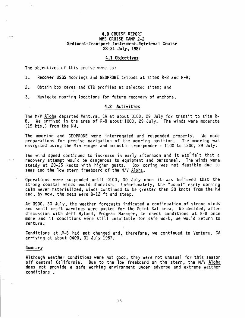
4.0 CRUISE REPORT MMS CRUISE CAMP 2-2
Sediment-Transport Instrument-Retrieval Cruise 28-31 July, 1987
4.1 Objectives
The objectives of this cruise were to:
1 . Recover USGS moorings and GEOPROBE tripods at sites R-8 and R-9;
2. Obtain box ceres and CTD profiles at selected sites; and
3. Navigate mooring locations for future recovery of anchors.
4.2 Activities
The M/V Aloha departed Ventura, CA at about 0100, 29 July for transit to site R-8 . We arrived in the area of R-8 about 1000, 29 July. The winds were moderate (15 kts.) from the NW.
The mooring and GEOPROBE were interrogated and responded properly. We made preparations for precise navigation of the mooring position. The mooring was navigated using the Miniranger and acoustic transponder - 1100 to 1300, 29 July.
The wind speed continued to increase in early afternoon and it was'felt that a recovery attempt would be dangerous to equipment and personnel. The winds were steady at 20-25 knots with higher gusts. Box coring was not feasible due to seas and the low stern freeboard of the M/V Aloha.
Operations were suspended until 0100, 30 July when it was believed that the strong coastal winds would diminish. Unfortunately, the "usual" early morning calm never materialized; winds continued to be greater than 20 knots from the NW and, by now, the seas were 8-12 ft and steep.
At 0900, 30 July, the weather forecasts indicated a continuation of strong winds and small craft warnings were posted for the Point Sal area. We decided, after discussion with Jeff Hyland, Program Manager, to check conditions at R-8 once more and if conditions were still unsuitable for safe work, we would return to Ventura.
Conditions at K-8 had not changed and, therefore, we continued to Ventura, CA arriving at about 0400, 31 July 1987.
Summary
Although weather conditions were not good, they were not unusual for this season off central California. Due to the low freeboard on the stern, the M/V Aloha does not provide a safe working environment under adverse and extreme weather conditions .
15
CRUISE REPORT FOR
MMS CRUISE CAMP 1-3, LEG 4 MMS CRUISE CAMP 2-1 MMS CRUISE CAMP 2-2
1.0 INTRODUCTION
During July, 1987, there were three cruises performed for the California OCS Phase II Monitoring Program (MMS Contract No. 14-12-0001-30262). This program is designed to monitor potential environmental changes at a series of regional stations and at two arrays of site-specific stations near oil production platforms in the western Santa Barbara Channel and Santa Maria Basin region of the California OCS. Platform Hidalgo (Lease P-0450) off Point Arguello has been selected for hard-bottom, site-specific monitoring, and Platform Julius {Lease P-0409) off Point Sal has been selected for soft-bottom, site-specific monitoring. Specific objectives of the program are:
1. To detect and measure potential long-term (or short-term) changes in the marine environment adjacent to oil and gas platforms; and
2. To determine whether changes observed in the marine environment during the monitoring period are caused by drilling-related activities or are a product of natural processes.
To accomplish these objectives, we are looking closely for potential biological changes and concomitant chemical or physical changes that can be linked to specific drilling events. An overall objective of the July cruises was to provide critical pre-drilling baseline data to help make these kinds of correlations and inferences.
The first cruise, CAMP 1-3, LEG 4 (Hard-Bottom Photosurveys/Search and Recovery Cruise) was the final leg of Cruise CAMP 1-3, May 1987. This cruise was per-formed to complete unfinished work which was the result of adverse weather conditions and equipment failures encountered on Cruise CAMP 1-3, LEG 3 in May, 1987. Cruise CAMP 2-1 (Soft-Bottom Life-History Cruise) was the first cruise of the second year for the California OCS Phase II Monitoring Program. The primary objective of this cruise was to collect benthic infauna samples for life-history analysis*. Cruise CAMP 2-2 (Sediment-Transport Instrument-Retrieval Cruise) had a primary objective to recover moored instruments (GEOPROBEs and current meters) which were deployed in the Platform Julius Study Area during May, 1987.
The Cruise Chief Scientists; Mr. Dane Hardin, Mr. James Campbell and Dr. David Cacchione have submitted reports (attached) of cruise activities.
International Underwater Contractor's M/V Aloha was the support vessel for each of the July cruises. The.cruises were scheduled as follows:
CAMP 1-3, LEG 4 Hard-Bottom Photosurveys/Search and Recovery Cruise
13-23 July, 1987 CAMP 2-1 Soft-Bottom Life-History Cruise
23-28 July, 1987 CAMP 2-2 Sediment-Transport Instrument-Retrieval Cruise
28-31 July, 1987
Recommended