1
Joint Recommendation regarding the protection of sandbanks slightly covered by seawater all the
time and reef features within the Inner Dowsing, Race Bank and North Ridge Site of Community
Importance under the Habitats Directive 92/43/EEC of 21 May 1992 under Articles 11 and 18 of
Regulation (EU) No 1380/2013 of the European Parliament and of the Council of 11 December
2013 on the Common Fisheries Policy (the Basic Regulation).
Contents
Recommendation
1 Introduction……………………………………………………………………………………………… 6
2 The Recommendations to be Implemented……………………………………………… 6
3 Control and enforcement of the proposed fisheries management measures.9
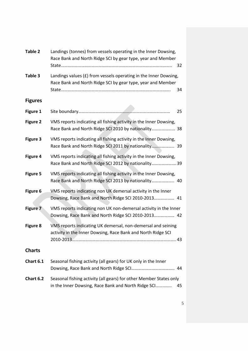
Tables
Table 1 Gear types prohibited in the closed areas of the site……………….. 7
Table 2 Coordinates of the site boundary…………………………………… …… 8
Table 3 Coordinates of proposed closure for all demersal trawl, dredge
and seine gears…… …………………………………………………………….. 8
Table 4 Coordinates of proposed closure for demersal trawl and dredge
only…………………………………………………………………………………… 9
Supporting Documentation
1 Introduction………………………………………………………………………………………. 11
1.1 General remarks…………………………………………………………………………………….. 11
1.2 Overall aim of the present proposal…......................................................... 12
1.3 Recommendation to be implemented…………………………………………………….. 13
2 Legal framework ……………………………………………………………………………….. 16
2.1 Common Fisheries Policy…………………………………………………………………………. 16
2.2 Fisheries Access to the Inner Dowsing, Race Bank and North Ridge SCI…… 17
2
2.3 Designation of the Inner Dowsing, Race Bank and North Ridge SCI……….. 17
3 Process……………………………………………………………………………………………… 18
3.1 Stakeholder workshop……………………………………………………………………………. 18
3.2 Involvement of the North Sea Advisory Council…………………………………….. 18
3.3 Rationale for measures………………………………………………………………………….. 18
3.4 Principles…………………………………………………………………………………………………… 21
3.5 Proposal scope…………………………………………………………………………………………… 22
Tables
Table 1 Gear types prohibited in the closed areas of the site………….. 13
Table 2 Coordinates of the site boundary………………………………………. 14
Table 3 Coordinates of proposed closure for all demersal trawl, dredge
and seine gears……………………………………………………………………. 14
Table 4 Coordinates of proposed closure for demersal trawl and dredge
only……………………………………………………………………………………… 15
Figures
Figure 1 Inner Dowsing, Race Bank and North Ridge SCI site map, including
proposals for areas to be managed as Annex I features……….. 16
List of Annexes:
Annex A – Overview of the 11 information items in the Commission’s guidelines from
2008……………………………………………………………………………………………………………………… 23
Annex B – Map of the UK marine Natura 2000 network………………………………………… 52
Annex C – Map and Coordinates for Inner Dowsing, Race Bank and North Ridge SCI reporting
zone with increased reporting………………………………………………………………………………. 53
Annex D – References…………………………………………………………………………………………… 55
3
Annex A – Overview of the 11 information items in the
Commission’s guidelines from 2008
1 Comprehensive description of the natural features including distribution
within the site……………………………………………………………………………………. 23
2 Scientific rationale for the site’s selection in accordance with the information
provided in the Natura 2000 data form. Intrisic value of its features. Specific
conservation objectives……………………………………………………………………… 24
2.1 Conservation objectives………………………………………………………………………………….. 24
3 Basis for the spatial extent of the site boundaries………………………………. 25
4 Threats to the long-term natural distribution, structure and functions of the
habitats and the long-term survival of associated species from different types
of fishing gear. List of other human activities in the area that could damage
the habitats………………………………………………………………………………………….. 25
4.1 All mobile demersal gears (including scallop dredges, beam trawls, otter trawls
and seines)…………………………………………………………………………………………………….. 26
4.2 All demersal static gears (including gillnets, trammel nets, longlines, pots and
traps)……………………………………………………………………………………………………………… 27
4.3 Other human activities……………………………………………………………………………….. 27
5 Fleet activity in the area and in the region, distribution of fleets (by nation,
gear and species) and information on target and bycatch species over 4 years
from 2010 to 2013 inclusive ……………………………………………………………………. 28
5.1 Validity of data……………………………………………………………………………………………. 28
5.1.1 Data analysis……………………………………………………………………………………………… 29
5.1.2 Data limitations…………………………………………………………………………………………… 30
5.2 Fleet activity by State…………………………………………………………………………………….. 30
5.3 Fleet activity by gear (fishing days, effort)……………………………………………………… 31
5.4 Landings values…………………………………………………………………………………………….. 31
4
5.5 Annual variation in fishing activity…………………………………………………………………. 36
5.6 Fleet activity by gear group – geographical distribution………………………………… 40
5.7 By-catch………………………………………………………………………………………………………… 43
6 Seasonal trends in fisheries over four years 2010-2013 inclusive……………. 44
7 Proposed fisheries management measures…………………………………………….. 46
7.1 Options for fisheries management measures……………………………………………….. 46
7.2 Proposed management option………………………………………………………………………. 47
7.3 Other fisheries measures which apply to the site…………………………………………… 47
8 Control measures envisaged by the Member State, possible ecological and
control buffer zones to ensure site protection and or effective control and
monitoring measures………………………………………………………………………………….. 48
8.1 Measures envisaged by Member State for Control, Enforcement and Compliance
…………………………………………………………………………………………………………………………… 48
8.1.1 Surface and aerial surveillance………………………………………………………………….. 48
8.1.2 Increased Reporting zone……………………………………………………………………………. 48
8.2 Vessel position monitoring……………………………………………………………………………. 49
8.3 Key provisions to include a EC regulation to manage the Inner Dowsing, Race
Bank and North Ridge SCI…………………………………………………………………………………… 49
9 Measures to monitor and assess the maintenance and/or recovery of the
features within the site…………………………………………………………………………….. 50
10 Coordination with neighbouring Member States as appropriate…………. 51
11 Evaluation of possible displacement of fishing effort and impact on new
areas……………………………………………………………………………………………………….. 51
Tables
Table 1 Number of vessels and pings (0-6 knots) associated with Inner
Dowsing, Race Bank and North Ridge SCI by year and Member
State…………………………………………………………………………………….. 30
5
Table 2 Landings (tonnes) from vessels operating in the Inner Dowsing,
Race Bank and North Ridge SCI by gear type, year and Member
State…………………………………………………………………………………….. 32
Table 3 Landings values (£) from vessels operating in the Inner Dowsing,
Race Bank and North Ridge SCI by gear type, year and Member
State……………………………………………………………………………………. 34
Figures
Figure 1 Site boundary……………………………………………………………………… 25
Figure 2 VMS reports indicating all fishing activity in the Inner Dowsing,
Race Bank and North Ridge SCI 2010 by nationality………………… 38
Figure 3 VMS reports indicating all fishing activity in the Inner Dowsing,
Race Bank and North Ridge SCI 2011 by nationality……………….. 39
Figure 4 VMS reports indicating all fishing activity in the Inner Dowsing,
Race Bank and North Ridge SCI 2012 by nationality…………………. 39
Figure 5 VMS reports indicating all fishing activity in the Inner Dowsing,
Race Bank and North Ridge SCI 2013 by nationality……………….. 40
Figure 6 VMS reports indicating non UK demersal activity in the Inner
Dowsing, Race Bank and North Ridge SCI 2010-2013……………… 41
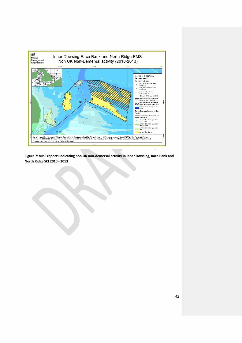
Figure 7 VMS reports indicating non UK non-demersal activity in the Inner
Dowsing, Race Bank and North Ridge SCI 2010-2013……………… 42
Figure 8 VMS reports indicating UK demersal, non-demersal and seining
activity in the Inner Dowsing, Race Bank and North Ridge SCI
2010-2013……………………………………………………………………………….. 43
Charts
Chart 6.1 Seasonal fishing activity (all gears) for UK only in the Inner
Dowsing, Race Bank and North Ridge SCI……………………………….. 44
Chart 6.2 Seasonal fishing activity (all gears) for other Member States only
in the Inner Dowsing, Race Bank and North Ridge SCI………….. 45
6
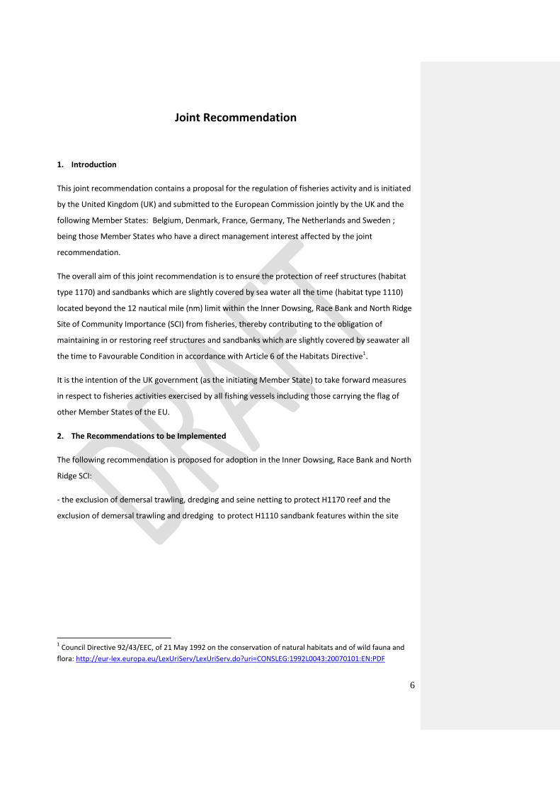
Joint Recommendation
1. Introduction
This joint recommendation contains a proposal for the regulation of fisheries activity and is initiated
by the United Kingdom (UK) and submitted to the European Commission jointly by the UK and the
following Member States: Belgium, Denmark, France, Germany, The Netherlands and Sweden ;
being those Member States who have a direct management interest affected by the joint
recommendation.
The overall aim of this joint recommendation is to ensure the protection of reef structures (habitat
type 1170) and sandbanks which are slightly covered by sea water all the time (habitat type 1110)
located beyond the 12 nautical mile (nm) limit within the Inner Dowsing, Race Bank and North Ridge
Site of Community Importance (SCI) from fisheries, thereby contributing to the obligation of
maintaining in or restoring reef structures and sandbanks which are slightly covered by seawater all
the time to Favourable Condition in accordance with Article 6 of the Habitats Directive1.
It is the intention of the UK government (as the initiating Member State) to take forward measures
in respect to fisheries activities exercised by all fishing vessels including those carrying the flag of
other Member States of the EU.
2. The Recommendations to be Implemented
The following recommendation is proposed for adoption in the Inner Dowsing, Race Bank and North
Ridge SCI:
- the exclusion of demersal trawling, dredging and seine netting to protect H1170 reef and the
exclusion of demersal trawling and dredging to protect H1110 sandbank features within the site
1 Council Directive 92/43/EEC, of 21 May 1992 on the conservation of natural habitats and of wild fauna and
flora: http://eur-lex.europa.eu/LexUriServ/LexUriServ.do?uri=CONSLEG:1992L0043:20070101:EN:PDF
7
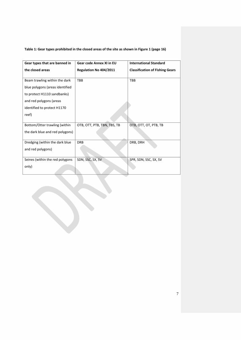
Table 1: Gear types prohibited in the closed areas of the site as shown in Figure 1 (page 16)
Gear types that are banned in
the closed areas
Gear code Annex XI in EU
Regulation No 404/2011
International Standard
Classification of Fishing Gears
Beam trawling within the dark
blue polygons (areas identified
to protect H1110 sandbanks)
and red polygons (areas
identified to protect H1170
reef)
TBB TBB
Bottom/Otter trawling (within
the dark blue and red polygons)
OTB, OTT, PTB, TBN, TBS, TB OTB, OTT, OT, PTB, TB
Dredging (within the dark blue
and red polygons)
DRB DRB, DRH
Seines (within the red polygons
only)
SDN, SSC, SX, SV SPR, SDN, SSC, SX, SV
8
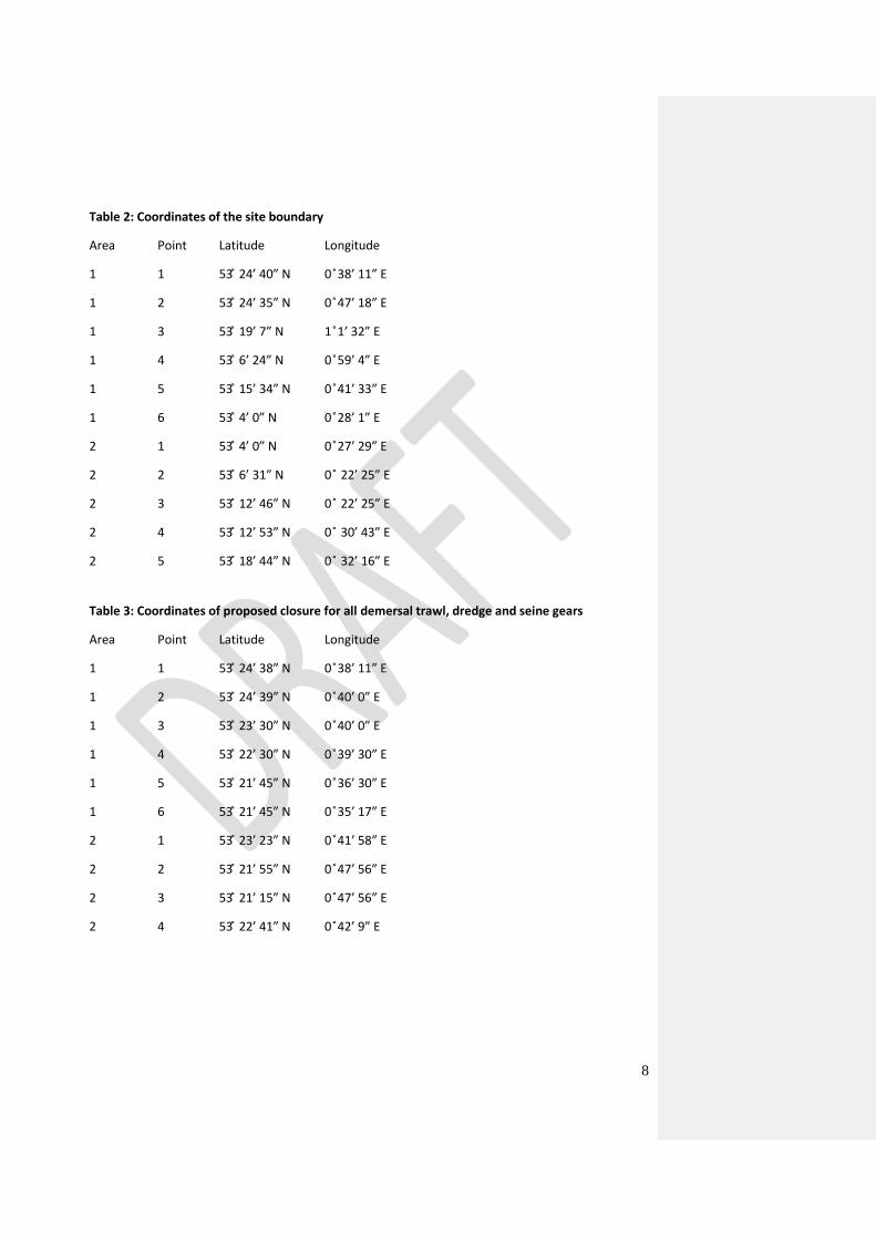
Table 2: Coordinates of the site boundary
Area Point Latitude Longitude
1 1 53 ̊ 24’ 40” N 0 ̊38’ 11” E
1 2 53 ̊ 24’ 35” N 0 ̊47’ 18” E
1 3 53 ̊ 19’ 7” N 1 ̊1’ 32” E
1 4 53 ̊ 6’ 24” N 0 ̊59’ 4” E
1 5 53 ̊ 15’ 34” N 0 ̊41’ 33” E
1 6 53 ̊ 4’ 0” N 0 ̊28’ 1” E
2 1 53 ̊ 4’ 0” N 0 ̊27’ 29” E
2 2 53 ̊ 6’ 31” N 0 ̊ 22’ 25” E
2 3 53 ̊ 12’ 46” N 0 ̊ 22’ 25” E
2 4 53 ̊ 12’ 53” N 0 ̊ 30’ 43” E
2 5 53 ̊ 18’ 44” N 0 ̊ 32’ 16” E
Table 3: Coordinates of proposed closure for all demersal trawl, dredge and seine gears
Area Point Latitude Longitude
1 1 53 ̊ 24’ 38” N 0 ̊38’ 11” E
1 2 53 ̊ 24’ 39” N 0 ̊40’ 0” E
1 3 53 ̊ 23’ 30” N 0 ̊40’ 0” E
1 4 53 ̊ 22’ 30” N 0 ̊39’ 30” E
1 5 53 ̊ 21’ 45” N 0 ̊36’ 30” E
1 6 53 ̊ 21’ 45” N 0 ̊35’ 17” E
2 1 53 ̊ 23’ 23” N 0 ̊41’ 58” E
2 2 53 ̊ 21’ 55” N 0 ̊47’ 56” E
2 3 53 ̊ 21’ 15” N 0 ̊47’ 56” E
2 4 53 ̊ 22’ 41” N 0 ̊42’ 9” E
9
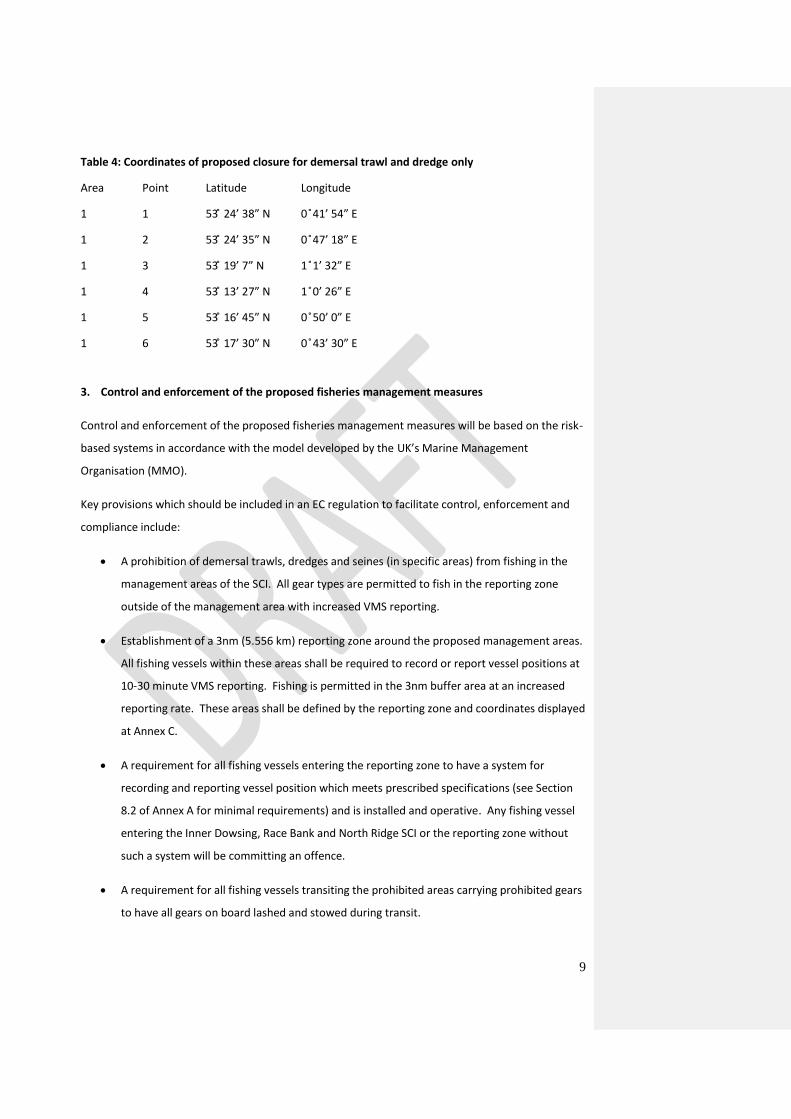
Table 4: Coordinates of proposed closure for demersal trawl and dredge only
Area Point Latitude Longitude
1 1 53 ̊ 24’ 38” N 0 ̊41’ 54” E
1 2 53 ̊ 24’ 35” N 0 ̊47’ 18” E
1 3 53 ̊ 19’ 7” N 1 ̊1’ 32” E
1 4 53 ̊ 13’ 27” N 1 ̊0’ 26” E
1 5 53 ̊ 16’ 45” N 0 ̊50’ 0” E
1 6 53 ̊ 17’ 30” N 0 ̊43’ 30” E
3. Control and enforcement of the proposed fisheries management measures
Control and enforcement of the proposed fisheries management measures will be based on the risk-
based systems in accordance with the model developed by the UK’s Marine Management
Organisation (MMO).
Key provisions which should be included in an EC regulation to facilitate control, enforcement and
compliance include:
A prohibition of demersal trawls, dredges and seines (in specific areas) from fishing in the
management areas of the SCI. All gear types are permitted to fish in the reporting zone
outside of the management area with increased VMS reporting.
Establishment of a 3nm (5.556 km) reporting zone around the proposed management areas.
All fishing vessels within these areas shall be required to record or report vessel positions at
10-30 minute VMS reporting. Fishing is permitted in the 3nm buffer area at an increased
reporting rate. These areas shall be defined by the reporting zone and coordinates displayed
at Annex C.
A requirement for all fishing vessels entering the reporting zone to have a system for
recording and reporting vessel position which meets prescribed specifications (see Section
8.2 of Annex A for minimal requirements) and is installed and operative. Any fishing vessel
entering the Inner Dowsing, Race Bank and North Ridge SCI or the reporting zone without
such a system will be committing an offence.
A requirement for all fishing vessels transiting the prohibited areas carrying prohibited gears
to have all gears on board lashed and stowed during transit.
10
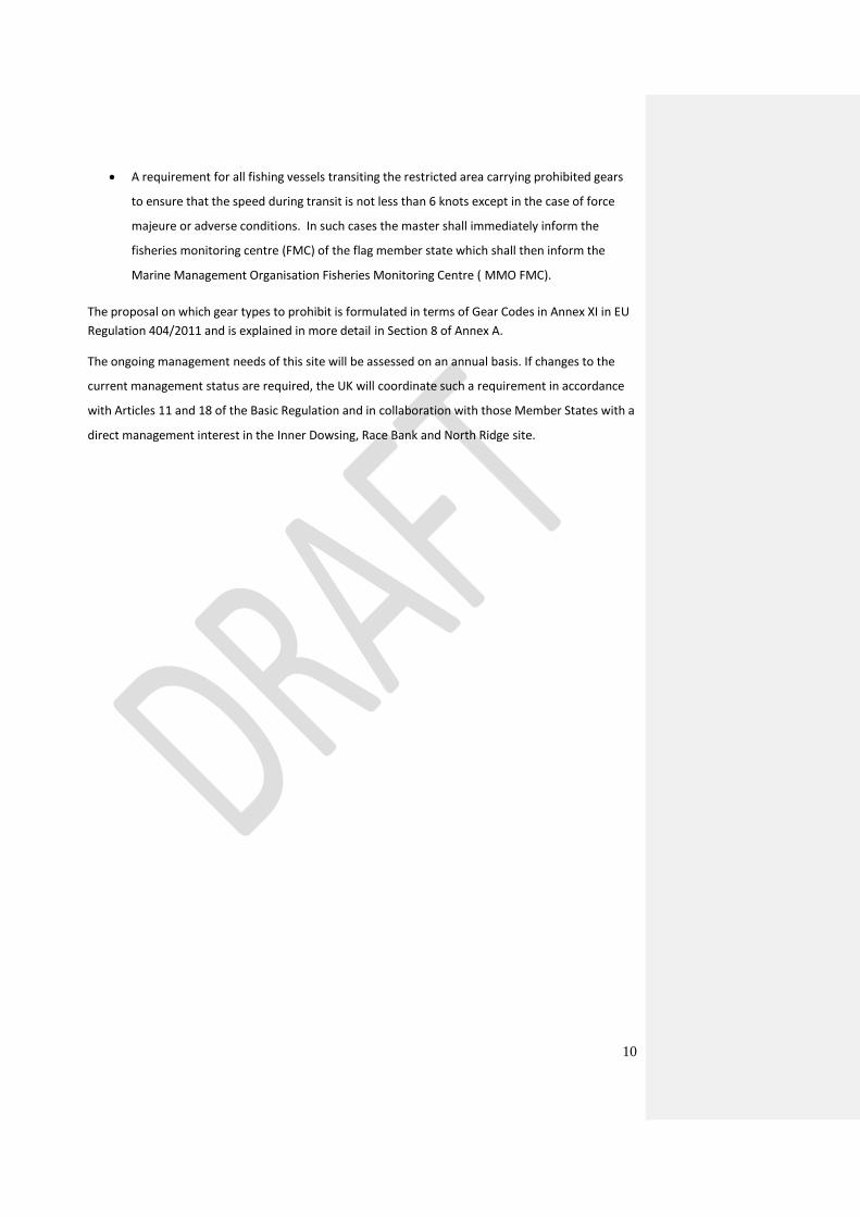
A requirement for all fishing vessels transiting the restricted area carrying prohibited gears
to ensure that the speed during transit is not less than 6 knots except in the case of force
majeure or adverse conditions. In such cases the master shall immediately inform the
fisheries monitoring centre (FMC) of the flag member state which shall then inform the
Marine Management Organisation Fisheries Monitoring Centre ( MMO FMC).
The proposal on which gear types to prohibit is formulated in terms of Gear Codes in Annex XI in EU
Regulation 404/2011 and is explained in more detail in Section 8 of Annex A.
The ongoing management needs of this site will be assessed on an annual basis. If changes to the
current management status are required, the UK will coordinate such a requirement in accordance
with Articles 11 and 18 of the Basic Regulation and in collaboration with those Member States with a
direct management interest in the Inner Dowsing, Race Bank and North Ridge site.
11
Joint Recommendation regarding the protection of sandbanks slightly covered by sea water all the
time and reef features within the Inner Dowsing, Race Bank and North Ridge Site of Community
Importance under the Habitats Directive 92/43/EEC of 21 May 1992 under Articles 11 and 18 of
Regulation (EU) No 1380/2013 of the European Parliament and of the Council of 11 December
2013 on the Common Fisheries Policy (the Basic Regulation).
Supporting Documentation
1. Introduction
1.1 General Remarks
The Inner Dowsing, Race Bank and North Ridge site was submitted to the European Commission as a
possible Special Area of Conservation (SAC) in August 2010 and approved by the Commission as a
Site of Community Importance (SCI) in November 2011.
This SCI crosses the 0-12nm area and extends into the offshore region. There is no Member State
historic access to the 6-12nm area of this site. For the 0-12 nm area, the UK’s MMO and the relevant
Inshore Fisheries Conservation Authority (IFCA) will identify appropriate management measures if
required. Management measures discussed within in this document relate only to features located
beyond the 12 nm limit.
Under Article 6 of the Habitats Directive, Member States have a duty to take appropriate steps to
avoid the deterioration of natural habitats for which SACs have been designated. Commercial fishing
has been identified as an activity which could adversely impact the integrity of the site’s features
and as such require being assessed and, if necessary, managed to reduce its impact. Inner Dowsing,
Race Bank and North Ridge SCI is currently assessed as being in unfavourable condition for both
habitat types 1170 and 1110 and has a conservation objective to maintain or restore these habitats
to a favourable condition.
The overall aim of this joint recommendation is to avoid deterioration and, where appropriate,
permit recovery in the condition of reef structures and sandbanks which are slightly covered by sea
water all the time from fishing activities that could damage the features, thereby contributing to the
obligation of restoring and maintaining these habitat types to favourable condition in accordance
with Article 6 of the Habitats Directive.
As the proposed management area of the Inner Dowsing, Race Bank and North Ridge site falls
beyond 12 nm of the UK coastline, all Member States have access to this part of the site. The UK,
The Netherlands, France and Belgium are currently the only Member States with an active fishing
12
interest in the site, however Germany, Sweden and Denmark all have an interest. It is the intention
of the UK government (as the initiating Member State) to take forward measures in respect to
fisheries activities exercised by all vessels including fishing vessels carrying the flag of other Member
States of the EU.
1.2 Overall aim of the present proposal
The overall aim of the present proposal is to ensure adequate protection of designated reef and
sandbank structures from fishing activities and thereby to contribute to the obligation of achieving
or maintaining favourable conservation status for the habitat types 1170 and 1110 in accordance
with Article 6(2) of the Habitats Directive; which states that Member States shall take appropriate
steps to avoid the deterioration of natural habitats for which the areas have been designated.
The Conservation Objective for the Inner Dowsing, Race Bank and North Ridge SCI is to maintain or
restore the habitat 1110 sandbanks which are slightly covered by seawater all the time in Favourable
Condition, and the habitat 1170 reef in Favourable Condition. According to advice provided by the
Joint Nature Conservation Committee (JNCC), the UK Government’s statutory scientific advisor for
offshore habitats, where fishing using demersal trawls or dredges overlaps with the feature it may
pose a risk to achieving the conservation objectives for the site. Management measures may focus
on the removal of pressures (in order to reduce the risk of not achieving the conservation objectives
to the lowest possible level), or the reduction of pressures (in order to reduce the risk of not
achieving the conservation objectives).
The UK is proposing to restrict fishing activity with demersal towed gears within areas of the site
where such activity could pose a risk to the restoration of the sites to favourable conservation
status. Where there is uncertainty regarding the impacts of fishing on the features, an “adaptive
management” approach is proposed, which would allow the site to move towards its conservation
objectives while providing the opportunity to improve our understanding of the impacts and
subsequently adapt management accordingly.
The content of the proposed fisheries management measures is explained in more detail in section
1.3 below.
The proposal has been reviewed by CEFAS (see section 3.4).
13
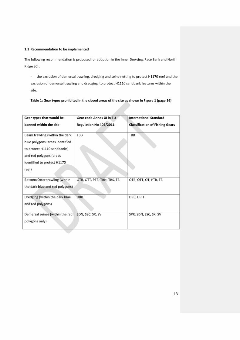
1.3 Recommendation to be implemented
The following recommendation is proposed for adoption in the Inner Dowsing, Race Bank and North
Ridge SCI :
- the exclusion of demersal trawling, dredging and seine netting to protect H1170 reef and the
exclusion of demersal trawling and dredging to protect H1110 sandbank features within the
site.
Table 1: Gear types prohibited in the closed areas of the site as shown in Figure 1 (page 16)
Gear types that would be
banned within the site
Gear code Annex XI in EU
Regulation No 404/2011
International Standard
Classification of Fishing Gears
Beam trawling (within the dark
blue polygons (areas identified
to protect H1110 sandbanks)
and red polygons (areas
identified to protect H1170
reef)
TBB TBB
Bottom/Otter trawling (within
the dark blue and red polygons)
OTB, OTT, PTB, TBN, TBS, TB OTB, OTT, OT, PTB, TB
Dredging (within the dark blue
and red polygons)
DRB DRB, DRH
Demersal seines (within the red
polygons only)
SDN, SSC, SX, SV SPR, SDN, SSC, SX, SV
14
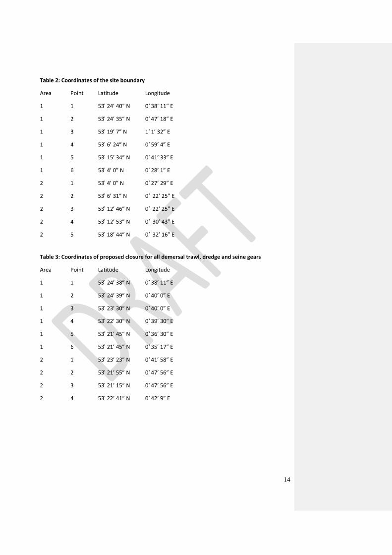
Table 2: Coordinates of the site boundary
Area Point Latitude Longitude
1 1 53 ̊ 24’ 40” N 0 ̊38’ 11” E
1 2 53 ̊ 24’ 35” N 0 ̊47’ 18” E
1 3 53 ̊ 19’ 7” N 1 ̊1’ 32” E
1 4 53 ̊ 6’ 24” N 0 ̊59’ 4” E
1 5 53 ̊ 15’ 34” N 0 ̊41’ 33” E
1 6 53 ̊ 4’ 0” N 0 ̊28’ 1” E
2 1 53 ̊ 4’ 0” N 0 ̊27’ 29” E
2 2 53 ̊ 6’ 31” N 0 ̊ 22’ 25” E
2 3 53 ̊ 12’ 46” N 0 ̊ 22’ 25” E
2 4 53 ̊ 12’ 53” N 0 ̊ 30’ 43” E
2 5 53 ̊ 18’ 44” N 0 ̊ 32’ 16” E
Table 3: Coordinates of proposed closure for all demersal trawl, dredge and seine gears
Area Point Latitude Longitude
1 1 53 ̊ 24’ 38” N 0 ̊38’ 11” E
1 2 53 ̊ 24’ 39” N 0 ̊40’ 0” E
1 3 53 ̊ 23’ 30” N 0 ̊40’ 0” E
1 4 53 ̊ 22’ 30” N 0 ̊39’ 30” E
1 5 53 ̊ 21’ 45” N 0 ̊36’ 30” E
1 6 53 ̊ 21’ 45” N 0 ̊35’ 17” E
2 1 53 ̊ 23’ 23” N 0 ̊41’ 58” E
2 2 53 ̊ 21’ 55” N 0 ̊47’ 56” E
2 3 53 ̊ 21’ 15” N 0 ̊47’ 56” E
2 4 53 ̊ 22’ 41” N 0 ̊42’ 9” E
15
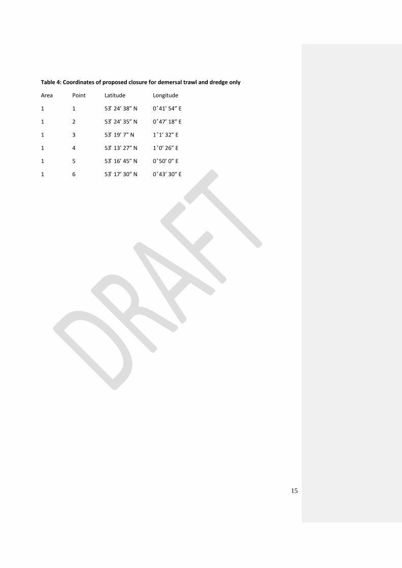
Table 4: Coordinates of proposed closure for demersal trawl and dredge only
Area Point Latitude Longitude
1 1 53 ̊ 24’ 38” N 0 ̊41’ 54” E
1 2 53 ̊ 24’ 35” N 0 ̊47’ 18” E
1 3 53 ̊ 19’ 7” N 1 ̊1’ 32” E
1 4 53 ̊ 13’ 27” N 1 ̊0’ 26” E
1 5 53 ̊ 16’ 45” N 0 ̊50’ 0” E
1 6 53 ̊ 17’ 30” N 0 ̊43’ 30” E
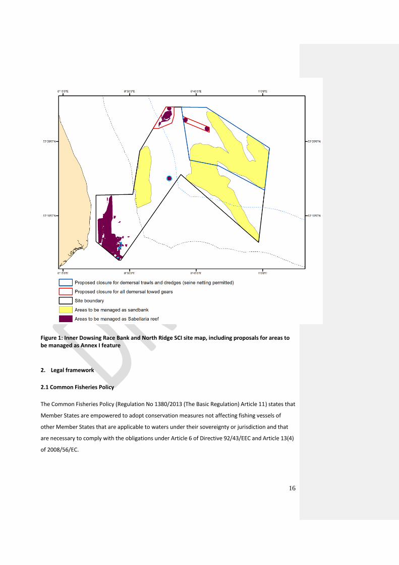
16
Figure 1: Inner Dowsing Race Bank and North Ridge SCI site map, including proposals for areas to be managed as Annex I feature
2. Legal framework
2.1 Common Fisheries Policy
The Common Fisheries Policy (Regulation No 1380/2013 (The Basic Regulation) Article 11) states that
Member States are empowered to adopt conservation measures not affecting fishing vessels of
other Member States that are applicable to waters under their sovereignty or jurisdiction and that
are necessary to comply with the obligations under Article 6 of Directive 92/43/EEC and Article 13(4)
of 2008/56/EC.
17
Where a Member State (“initiating Member State”) considers that measures need to be adopted for
the purpose of complying with the obligations referred to above, and other Member States have a
direct management interest in the fishery to be affected by such measures, the European
Commission shall be empowered to adopt such measures, upon request, by means of delegated
acts. For this purpose cooperation between Member States having a direct management interest is
foreseen with a view to formulating a joint recommendation in agreement on draft fisheries
management measures to be forwarded to the Commission.
The initiating Member State shall provide the Commission and the other Member States having a
direct management interest with relevant information on the measures required, including their
rationale, scientific evidence in support and details on their practical implementation and
enforcement. Member States shall consult the relevant Advisory Councils.
The initiating Member State and the other Member States having a direct management interest may
submit a joint recommendation within six months from the provision of sufficient information. The
Commission shall adopt the measures, taking into account any available scientific advice, within
three months from receipt of a complete request (Reg 1380/2013, Articles 11 and 18).
The following chapters describe how the UK, as the initiating Member State, has taken the
Commission’s criteria for decision making into account, as well as the requirements for regional
coordination in line with the new Basic Regulation.
2.2 Fisheries Access to the Inner Dowsing, Race Bank and North Ridge SCI
In accordance with the Basic Regulation the following Member States operate demersal towed gears
within the proposed management zone: UK, The Netherlands, France and Belgium.
2.3 Designation of the Inner Dowsing, Race Bank and North Ridge SCI
The Offshore Marine Conservation (Natural Habitats, &c.) Regulations 2007 (SI 2007/1842)2, as
amended, provide the legal basis for the designation of Natura 2000 sites in offshore waters and
areas of the extended continental shelf in the UK. In accordance with Regulation 7 of the above
Regulations, the Inner Dowsing, Race Bank and North Ridge site was submitted to the European
Commission as a Candidate Special Area of Conservation (cSAC) in August 2010 and adopted by the
Commission as a SCI in November 2011. In accordance with Article 4(4) of the Habitats Directive,
2 http://www.legislation.gov.uk/uksi/2007/1842/contents/made
18
Member States have a maximum of six years from the site being adopted as a SCI to implement the
necessary management measures and formally designate the site as a SAC.
3. Process
This chapter describes the process from when the initiative to protect sandbank and reef structures
from fisheries activities at Inner Dowsing, Race Bank and North Ridge SCI were commenced at a
fisheries management workshop held in The Hague in August 2014 by the Department for
Environment Food and Rural Affairs (Defra) until the submission of fisheries management measures
in the form of ‘A Joint Recommendation’ by the UK, The Netherlands, France and Belgium to the
European Commission.
3.1 Stakeholder workshop
Two workshops were held in the Netherlands and the UK in August 2014 and May 2015, with the
intention of allowing stakeholder input to management measures. The meetings were attended by
representatives of the Dutch, French, Belgian and UK fishing industries and environmental Non-
Governmental Organisations (NGOs).
Participants were provided with a fisheries management options paper for the site, which discussed
the risk to achievement of the conservation objectives associated with a range of management
options, and they were invited to contribute to the process of developing appropriate management
measures to achieve the conservation objectives while complying with the principals of
proportionality and non-discrimination.
While it was not possible to achieve agreement on management measures during these meetings,
stakeholder views were recorded (meeting minutes are available in a separate annex) and taken into
consideration in subsequent drafting of measures.
3.2 Involvement of the North Sea Advisory Council (to be completed)
3.3 Rationale for measures
Impacts of mobile demersal gears (including scallop dredges, beam trawls, otter trawls and
seines)
Reefs (1170)
Demersal towed gears have the potential to effect the long term natural distribution of the
Sabellaria spinulosa reefs and the structure and function of their associated biological communities.
Loss of Sabellaria spinulosa reefs in the North East Atlantic has been attributed to the long-term
19
effects of various fishing practices, predominantly that of demersal towed gear (Jones et al, 2000;
Holt et al. 1998). Trawls break apart S. spinulosa tubes, resulting in direct mortality of the worms and
a reduction of the structure and complexity of the habitat, which may no longer support associated
animals and plants (UK Biodiversity Action Plan, 2000).
Consequently, it is concluded that use of any mobile demersal gear (including seine netting) would
result in an unacceptable risk to the conservation objectives for these features. This is consistent
with the UK Government’s precautionary approach to take a “remove risk” option for reefs as set
out in Section 7 of Annex A.
Sandbanks which are slightly covered by sea water all the time (1110)
Whilst it is unlikely that demersal towed gear can affect the long-term natural distribution of
sandbanks, there is evidence to indicate that the use of demersal towed gears can impact the
structure and function of the habitat and the long term survival of its associated species.
The extent to which mobile gear impacts on sand and gravel communities can vary considerably,
according to the type of gear, the intensity of fishing and the sediment composition. Trawling and
dredging tend to cause increased mortality of fragile and long lived species and favour opportunistic,
disturbance-tolerant species (Bergman & Van Santbrink, 2000; Eleftheriou & Robertson, 1992). Some
particularly sensitive species may disappear entirely (Bergman & Van Santbrink, 2000). The net result
is benthic communities modified to varying degrees relative to the un-impacted state (Bergman &
Van Santbrink, 2000; Kaiser et al. 2006).
In higher energy locations, for example the sandy bank tops or wave and/or tide exposed areas the
associated fauna tend to be well adapted to disturbance and as a result are more tolerant of fishing-
related disturbance (Dernie et al. 2003; Hiddink et al. 2006). The habitat may be maintained in a
modified state; however modification is likely to be low relative to natural variation. In lower energy
locations, such as muddy sands and sand in deep water, or on the flanks and towards troughs
between banks, sediments tend to be more stable and their associated fauna less tolerant of
disturbance (Kaiser et al. 2006; Hiddink et al. 2006). The habitat may be maintained in a modified
state with reduced abundance of fragile, long lived species.
Considering the degree of uncertainty regarding the impacts of trawling and dredging and the level
at which their effects would be considered unacceptable, it was decided to implement an “adaptive
management” approach, whereby a proportion of the feature will be closed to these gears and
subsequently monitored to improve our understanding of impacts and inform future management.
20
This is consistent with the UK Government’s precautionary approach to take a “reduce risk” option
for sandbank features as set out in Section 7 of Annex A.
Demersal seines (Danish and Scottish seines) lack the heavy penetrating gear components of other
demersal trawls, such as otter doors and trawl shoes (Suuronen et al. 2012; Donaldson et al 2010),
so the risk of impact to the sandbank feature is considered likely to be lower. In this case, the risk to
the achievement of the conservation objective for the feature sandbanks slightly covered by
seawater is considered to be sufficiently low that no additional management is considered
necessary. However, if monitoring indicates impacts from these gears, it may be necessary to impose
some degree of management in the future.
Impacts of static demersal gears (including gillnets, trammel nets, longlines, pots and traps)
Reefs (1170)
It is unlikely that demersal static gears at moderate levels of fishing effort will have a significant
effect on the long-term natural distribution of Sabellaria reefs, or on the structure and function of
their associated biological communities. Sensitivity of Sabellaria reefs to static gears is low to
medium depending on fishing intensity (Hall et al. 2008; Tillin et al. 2010). However, effects at high
levels of fishing intensity are uncertain and it is possible in some circumstances that damage to reef
structures could exceed their capacity to recover. We have little evidence to define what ‘high’
activity levels are.
The risk to the achievement of the conservation objective is considered to be sufficiently low that no
additional management is considered necessary for demersal static gears. However, if monitoring
indicates impacts from these gears, it may be necessary to introduce some degree of management
in the future.
Sandbanks which are slightly covered by sea water all the time (1110)
Demersal static gears are considered unlikely to have a significant effect on the long term natural
distribution of sandbanks, or on the structure and function of their associated biological
communities at any level.
The risk to the achievement of the conservation objective is considered to be sufficiently low that no
additional management is considered necessary for demersal static gears. However, if monitoring
21
indicates impacts from these gears, it may be necessary to introduce some degree of management
in the future.
Information on fishing activity can be found at section 5 of Annex A.
3.4 Principles
The UK Government is responsible for ensuring favourable conservation status of designated marine
habitats and species in its respective Natura 2000 network and for taking appropriate steps to avoid
the deterioration of natural habitats as well as disturbance of the species for which the Natura 2000
site has been designated.
Based on scientific advice from JNCC and Natural England concerning the level of risk associated with
a range of management options, the UK has decided to protect reef structures (H1170) and
sandbanks slightly covered by sea water all the time (H1110) from physical disturbances due to
demersal towed gear.
When formulating the present proposal, the following principles have been focal points:
1. Sound scientific basis
This proposal for fisheries management measures is based on scientific evidence and advice, and
takes all relevant information into account. JNCC has provided scientific advice in relation to the
principles and methods pursued in the present proposal. The proposal has also been reviewed by
CEFAS. The advice from CEFAS was that the proposed approach is considered to be consistent with
ensuring favourable conservation status of designated marine habitats and species in its respective
Natura 2000 network and for taking appropriate steps to avoid the deterioration of natural habitats
as well as disturbance of the species for which the Natura 2000 site has been designated whilst at
the same time minimising the effect on the fishing industry.
2. Stakeholder involvement
An important element of the process of formulating fisheries management measures has been the
involvement of stakeholders. This has been outlined in further detail in sections 3.1 and 3.2.
22
3. Transparency
In this proposal the UK has been transparent on the data being used, the steps being taken and the
methodology used, as well as the involvement of stakeholders.
4. Proportionality
An approach was sought that would deliver a regulatory proposal that delivers a key contribution to
the achievement of the conservation objectives while minimising the effect on the fishing industry. A
key safeguard in the process to deliver such an outcome was to follow the European Commission
guidance in this regard, which described a proportional approach towards balancing sustainable
exploitation of resources and the need to conserve important habitats, including a precautionary
approach to fisheries management.
5. Non discrimination
The proposal will need to ensure that measures are not applied in a discriminatory manner. A
coordinated approach between Member States is the only way of ensuring non discrimination for
fleets affected by the proposed measures. Ultimately, a proposal is presented to the European
Commission for regulation in the framework of the Common Fisheries Policy, ensuring a level playing
field for the fishing sector affected.
3.5 Proposal scope
The proposed management boundary for a closure to demersal trawls and dredges covers
approximately 30% of the site and approximately 51% of the H1110 sandbank feature within the site
(approximately 61% of the H1110 sandbank feature in the offshore part of the site).
The proposed management boundaries for a closure to demersal trawls, dredges and seines covers
approximately 3% of the site and approximately 15% of the H1170 reef feature within the site (100%
of the H1170 reef feature in the offshore part of the site).
List of Annexes:
Annex A – Overview of the 11 information items in the Commission’s guidelines from 2008
Annex B – Map of UK marine Natura 2000 network
Annex C – Map and Coordinates for Inner Dowsing, Race Bank and North Ridge SCI reporting zone
with increased reporting
Annex D – References
23
Annex A – Overview of the 11 information items in the Commission’s guidelines from 2008
The Commission has issued guidance on a consistent approach to requests for fisheries management
measures under the Common Fisheries Policy3. Accordingly, this document provides the scientific
and technical information required to support a formal request to the Commission for fisheries
regulation under the Common fisheries Policy.
1 Comprehensive description of the natural features including distribution within the site
The Inner Dowsing, Race Bank and North Ridge site is located off the south Lincolnshire coast. The
site occupies the Wash Approaches. Water depths are generally shallow and mostly less than 30m.
The area encompasses a wide range of sandbank types and biogenic reef formed by ross worm
Sabellaria spinulosa. These features lie almost entirely on the glacial till of the Bolders Bank
Formation, which forms much of the seabed topography.
The group of banks within the Wash Approaches are made up of fine to medium sands derived from
coastal erosion processes following the last glacial retreat and marine inundation. Individual banks
have been delineated using a slope analysis methodology (Klein, 2006) and a precautionary margin
of 500m has been added to each bank to account for uncertainty in feature extent and the potential
for bank migration and/or oscillation. The tops of the banks are characterised by low diversity
communities dominated by polychaete worms and mobile amphipod crustaceans. The trough areas
between the banks are composed of mixed and gravelly sands, predominantly as veneers over
glacial till. In these areas, diverse mosaics of biotopes occur, which are dominated by a number of
nemertean worm and polychaete species.
Sabellaria spinulosa reef is an ephemeral feature, and thus presents a challenge to precisely map its
location at any instance in time. Biogenic reefs formed by Sabellaria spinulosa allow colonisation by
other species not otherwise associated with adjacent, lower sediment habitats. Areas of Sabellaria
reef support attached epifauna such as byrozoans, hydroids, sponges and anemones. Additional
fauna also includes polychaetes, squat lobsters, crabs, the common lobster Homarus gammarus and
notable the commercially exploitable pink shrimp Pandalus montagui. As certain types of ground
truthing data provide information on reef presence but not extent, a 500m margin has been
included as part of the feature for point and polyline records, as shown in Figure 1. This is considered
appropriate to account for uncertainty in reef extent.
3 http://ec.europa.eu/environment/nature/natura2000/marine/docs/fish_measures.pdf
24
2 Scientific rationale for the site’s selection in accordance with the information provided in
the Natura 2000 data form. Intrinsic value of its features. Specific conservation objectives
The Inner Dowsing, Race Bank and North Ridge sites lies off the Lincolnshire coast and contains a
wide range of sandbank types (banks bordering channels, linear relict banks, sinusoidal banks with
distinctive subsidiary banks) and associated channels not fully represented in other UK Natura 2000
sites. The site holds a significant position at the entrance to the Wash and is important with respect
to tidal flows and sediment transport processes into the Wash and along the Norfolk coast.
Topographically, the sublittoral sandbanks conform well to the Annex I definition, and within the site
there are examples of banks composed of different sediment types. The banks are largely composed
of gravelly sand with areas of sandier and muddier sediments also present. The biological diversity at
the site is considered to incorporate a large number of the biological communities associated with
Annex I sandbanks.
Sabellaria spinulosa reef habitat represents biogenic reef in an open, tide-swept situation on sand
and gravelly sand habitat. The interest features are located in full salinity waters, with coastal
influences. Despite the widespread occurrence of the species Spinulosa sabellaria, there are few
known areas of well developed biogenic reef formed by the species in UK waters. Reef data within
the site comes from a variety of sources, with varying degrees of associated confidence. Additionally,
the dynamic nature of Sabellaria presents challenges to precisely mapping its location. Therefore
reef locations shown in Figure 1 represent best judgement on those parts of the site that should be
managed as Annex I reef feature.
2.1 Conservation objectives
Conservation objectives set out the desired state for the protected features of an MPA. The
conservation objectives for the protected features of the Inner Dowsing, Race Bank and North Ridge
cSAC/SCI have been set based on knowledge of the condition of the protected features at the time
of writing.
The conservation objectives for the protected features of the MPA are:
Subject to natural change, maintain or restore the sandbanks in favourable condition, in particular
the sub-features:
Gravelly muddy sand communities
Dynamic sand communities
Subject to natural change, maintain or restore the reefs in favourable condition.
25
3 Basis for the spatial extent of the site boundaries
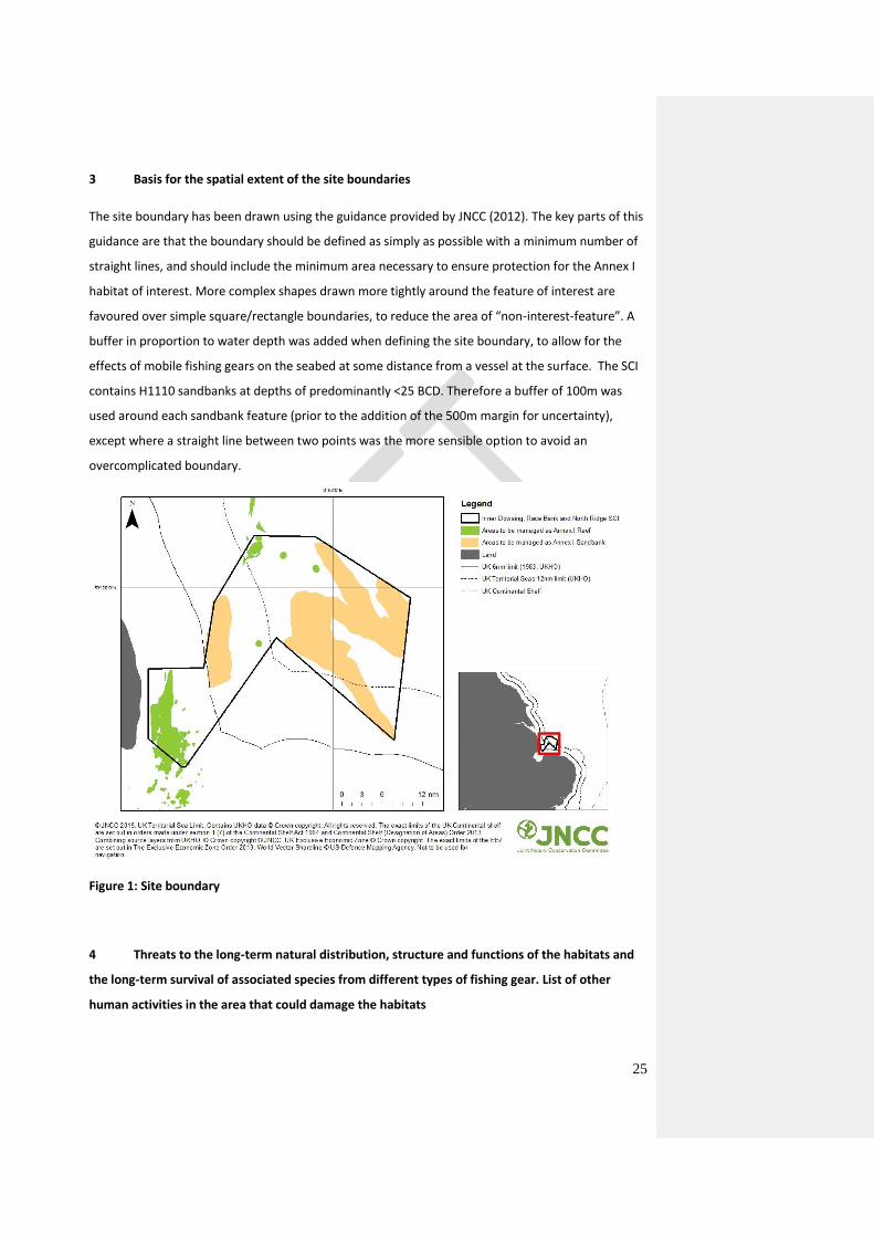
The site boundary has been drawn using the guidance provided by JNCC (2012). The key parts of this
guidance are that the boundary should be defined as simply as possible with a minimum number of
straight lines, and should include the minimum area necessary to ensure protection for the Annex I
habitat of interest. More complex shapes drawn more tightly around the feature of interest are
favoured over simple square/rectangle boundaries, to reduce the area of “non-interest-feature”. A
buffer in proportion to water depth was added when defining the site boundary, to allow for the
effects of mobile fishing gears on the seabed at some distance from a vessel at the surface. The SCI
contains H1110 sandbanks at depths of predominantly <25 BCD. Therefore a buffer of 100m was
used around each sandbank feature (prior to the addition of the 500m margin for uncertainty),
except where a straight line between two points was the more sensible option to avoid an
overcomplicated boundary.
Figure 1: Site boundary
4 Threats to the long-term natural distribution, structure and functions of the habitats and
the long-term survival of associated species from different types of fishing gear. List of other
human activities in the area that could damage the habitats
26
4.1 All mobile demersal gears (including scallop dredges, beam trawls, otter trawls and seines)
Demersal towed gears have the potential to effect the long term natural distribution of the
Sabellaria spinulosa reefs and the structure and function of their associated biological communities.
Loss of Sabellaria spinulosa reefs in the North East Atlantic has been attributed to the long-term
effects of various fishing practices, predominantly that of demersal towed gear (Jones et al, 2000;
Holt at al. 1998). Trawls break apart Sabellaria spinulosa tubes, resulting in direct mortality of the
worms and a reduction of the structure and complexity of the habitat, which may no longer support
associated animals and plants (UK Biodiversity Action Plan, 2000).
Consequently, it is concluded that use of any mobile demersal gear (including seine netting) would
result in an unacceptable risk to the conservation objectives for these features.
Whilst it is unlikely that demersal towed gear can affect the long-term natural distribution of
sandbanks, there is evidence to indicate that the use of demersal towed gears can impact the
structure and function of the habitat and the long term survival of its associated species.
The extent to which mobile gear impacts on sand and gravel communities can vary considerably,
according to the type of gear, the intensity of fishing and the sediment composition. Trawling and
dredging tend to cause increased mortality of fragile and long lived species and favour opportunistic,
disturbance-tolerant species (Bergman & Van Santbrink, 2000; Eleftheriou & Robertson, 1992). Some
particularly sensitive species may disappear entirely (Bergman & Van Santbrink, 2000). The net result
is benthic communities modified to varying degrees relative to the un-impacted state (Bergman &
Van Santbrink, 2000; Kaiser et al. 2006).
In higher energy locations, for example the sandy bank tops or wave and/or tide exposed areas the
associated fauna tend to be well adapted to disturbance and as a result are more tolerant of fishing-
related disturbance (Dernie et al. 2003; Hiddink et al. 2006). The habitat may be maintained in a
modified state; however modification is likely to be low relative to natural variation. In lower energy
locations, such as muddy sands and sand in deep water, or on the flanks and towards troughs
between banks, sediments tend to be more stable and their associated fauna less tolerant of
disturbance (Kaiser et al. 2006; Hiddink et al. 2006). The habitat may be maintained in a modified
state with reduced abundance of fragile, long lived species.
Considering the degree of uncertainty regarding the impacts of trawling and dredging and the level
at which their effects would be considered unacceptable, it was decided to implement an “adaptive
management” approach, whereby a proportion of the feature will be closed to these gears and
subsequently monitored to improve our understanding of impacts and inform future management.
27
Demersal seines (Danish and Scottish seines) lack the heavy penetrating gear components of other
demersal trawls, such as otter doors and trawl shoes (Suuronen et al. 2012; Donaldson et al 2010),
so the risk of impact to the sandbank feature is considered likely to be lower. In this case, the risk to
the achievement of the conservation objective for sandbanks slightly covered by seawater is
considered to be sufficiently low that no additional management is considered necessary. However,
if monitoring indicates impacts from these gears, it may be necessary to impose some degree of
management in the future.
4.2 All demersal static gears (including gillnets, trammel nets, longlines, pots and traps)
It is unlikely that demersal static gears at moderate levels of fishing effort will have a significant
effect on the long-term natural distribution of Sabellaria reefs, or on the structure and function of
their associated biological communities. Sensitivity of Sabellaria reefs to static gears is low to
medium depending on fishing intensity (Hall et al. 2008; Tillin et al. 2010). However, effects at high
levels of fishing intensity are uncertain and it is possible in some circumstances that damage to reef
structures could exceed their capacity to recover.
The risk to the achievement of the conservation objective is considered to be sufficiently low that no
additional management is considered necessary for demersal static gears. However, if monitoring
indicates impacts from these gears, it may be necessary to introduce some degree of management
in the future.
Demersal static gears are considered unlikely to have a significant effect on the long term natural
distribution of sandbanks, or on the structure and function of their associated biological
communities at any level.
The risk to the achievement of the conservation objective is considered to be sufficiently low that no
additional management is considered necessary for demersal static gears. However, if monitoring
indicates impacts from these gears, it may be necessary to introduce some degree of management
in the future.
4.3 Other human activities
The information within this section represents current knowledge of the nature and extent of
activities taking place within or close to the site.
28
Two abandoned, explorative oil wells occur within the site, and four pipelines cross the north of the
MPA. There is also substantial windfarm activity, including Inner Dowsing, Lincs and Lynn wind farms
in the Inner Dowsing sandbank and Lynn Knock area, with a combined capacity of 850 megawatts.
Energy cables connect these wind farms to the Lincolnshire coast. A wind farm has also been
consented in the Race Bank area. Two areas licensed for aggregate extraction overlap with the MPA,
a further area is under application. Existing licensed activities that take place or may take place in
the future within Inner Dowsing, Race Bank and North Ridge SCI will continue to be managed in line
with relevant legislation and application processes by the competent authorities.
There is a low to moderate density of commercial shipping in the site, including cargo vessels,
passenger vessels and port service craft. Under international law, ships have a rite of passage at sea
including in areas designated as MPAs. The pressures associated with shipping activity within Inner
Dowsing, Race Bank and North Ridge SCI are not considered likely to impact the protected features
of the site.
5 Fleet activity in the area and in the region, distribution of fleets (by nation, gear and
species) and information on target and bycatch species over 4 years from 2010 to 2013 inclusive
5.1 Validity of data
In this section relevant fleet statistics for the years 2010-2013 are provided as requested by the
European Commission guidance. The UK, as the initiating Member State, analysed fishing from
Member States active in the Inner Dowsing, Race Bank and North Ridge SCI over a four year period.
This approach is consistent with other management proposal methodologies across Member States.
A four year dataset is considered to be representative of the contemporary fisheries carried out in
the area and thus valid for the purpose of underpinning the current proposal.
Overall, fisheries have been changing since the early 2000s as a result of changes in economic and
regulatory conditions, e.g. fuel prices and engine efficiencies, the introduction of individual
transferable quota (ITQ) systems4 in various forms. Fishing fleets have been reduced in terms of the
number of vessels and fishing effort has decreased. Fishing opportunities are dictated by stock
status, market conditions, fuel prices and technological opportunities as well as quota availability. In
addition, policy decisions on alternative use of marine habitat, sustainable exploration and
environmental policies will influence fishing opportunities.
4 Individual transferable quotas (ITQs) are a type of catch share system, which is a tool used by some
governments to manage fisheries
29
The fisheries system is dynamic and sound judgement is required when using the data. However,
more recent datasets are expected to improve our understanding of the structure of fisheries.
Vessels from four Member States have been present within the relevant area according to VMS
reports or “pings”. However, French vessels routinely report every hour and not every two hours
like all other Member State vessels. The data concerning the number of French vessels will be
accurate but their activity through pings may appear distorted. To maintain consistency across all
vessels and Member States data, the information on French vessels has been displayed how it was
received into the MMO FMC, therefore it has not been altered to reflect possible one hour vessel
pings as this could alter the validity of the data further. To establish which vessels specifically report
at a higher level would require additional processing and information.
To note: Unknown gear classification relates to a specific VMS report which does not have valid
corresponding log book information.
5.1.1 Data analysis
Data presented has been analysed by applying the standard methodology used to identify whether
or not vessels have been fishing in a specified spatial area. VMS reports (“pings”) were used to
indicate vessel fishing activity based on the speed of the vessel as contained within the VMS report.
Each ping was classified as indicative of fishing activity if the speed was greater than or equal to zero
knot and less than or equal to six knots5.
Each speed filtered VMS ping (0-6 knots) received from a vessel in ICES statistical rectangle 35F0 was
extracted from the UK VMS system. Each ping will hold the following information: the vessel
identity (CFR) number; position and speed; and the date and time of that ping. The fishing pings
from the rectangle concerned are then processed in GIS software to identify whether the position
was inside or outside the Inner Dowsing, Race Bank and North Ridge SCI or the proposed
management areas. This provides a proportion of pings falling within the area for the vessels of
each Member State.
This proportion was then applied to landings data to allow estimates of landings value and quantity
derived from within the Inner Dowsing, Race Bank and North Ridge SCI or proposed management
areas by non-UK vessels. Landings values and quantities for UK vessels were derived from UK
statistical data held by the MMO. Landings values and quantities for non-UK vessels were derived
5 Article 50 of Council Regulation (EC) No 1224/2009 : http://eur-
lex.europa.eu/LexUriServ/LexUriServ.do?uri=OJ:L:2009:343:0001:0050:EN:PDF
30
from the Scientific, Technical and Economic Committee for Fisheries (STECF)6 and from the Defra
coordinated data call in the summer of 2015.
5.1.2 Data limitations
The data provided in this section is subject to several limitations:
1. Data are only available from vessels that are required to carry EU VMS (i.e. vessels 15 metres
and above in length). As such their pattern of activity may differ from vessels of less than 15
metres in length.
2. The speed thresholds (0-6 knots) used to make assumptions as to whether a vessel is fishing
or not only provide indications, not definitive proof of fishing and may not be valid for all
gear types.
3. The proportion of activity inside an area is based on the number of pings as opposed to
actual fishing time.
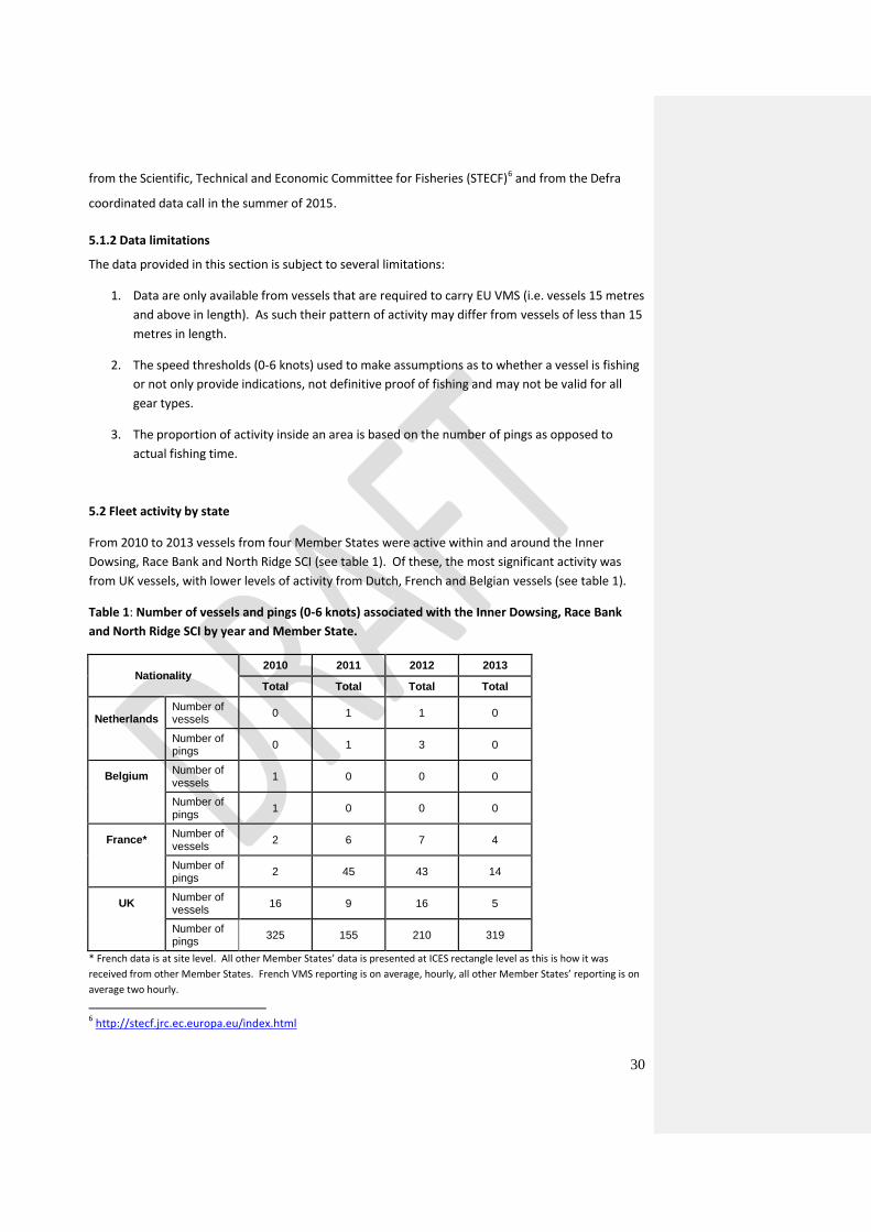
5.2 Fleet activity by state
From 2010 to 2013 vessels from four Member States were active within and around the Inner
Dowsing, Race Bank and North Ridge SCI (see table 1). Of these, the most significant activity was
from UK vessels, with lower levels of activity from Dutch, French and Belgian vessels (see table 1).
Table 1: Number of vessels and pings (0-6 knots) associated with the Inner Dowsing, Race Bank
and North Ridge SCI by year and Member State.
Nationality 2010 2011 2012 2013
Total Total Total Total
Netherlands
Number of vessels
0 1 1 0
Number of pings
0 1 3 0
Belgium Number of vessels
1 0 0 0
Number of pings
1 0 0 0
France* Number of vessels
2 6 7 4
Number of pings
2 45 43 14
UK Number of vessels
16 9 16 5
Number of pings
325 155 210 319
* French data is at site level. All other Member States’ data is presented at ICES rectangle level as this is how it was
received from other Member States. French VMS reporting is on average, hourly, all other Member States’ reporting is on
average two hourly.
6 http://stecf.jrc.ec.europa.eu/index.html

31
5.3 Fleet activity by gear (fishing days, effort)
5.4 Landings values
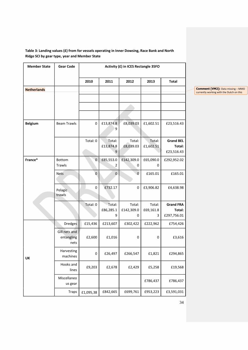
As shown in Tables 2 and 3 the gear groups of major importance in terms of (quantity and value of
landings) include (1) beam trawls directed at demersal fish (flatfish), (2) otter board bottom trawls
for demersal fish, (3) otter board bottom trawls for demersal and semi pelagic fish. Fishing for these
species occurs throughout the mid and southern North Sea.
The fisheries data for 2010 – 2013 inclusive in the Inner Dowsing, Race Bank and North Ridge SCI
involved similar gear types from French and Belgian beam trawls and bottom trawls. The UK fleet
used a variety of gears but predominately dredging, trawls, traps (UK inshore vessels), and
harvesting machines (suction dredges). This is gear information for the whole ICES rectangle 35F0 so
gears used outside of the management boundary and SCI may be included.
32
Table 2: Landings (tonnes) from vessels operating in Inner Dowsing, Race Bank and North Ridge
SCI by gear type, year and Member State
Member State Gear Code Activity (Tonnes) in ICES Rectangle 35FO
2010 2011 2012 2013 Total
Netherlands
Belgium Beam Trawls
(TBB)
0 2.755 2.36 0.495 5.63
Total:
0
Total:
2.755
Total: 2.36 Total:
0.495
Grand BEL
Total:
5.63
France* Bottom
Trawls
0 80.34916 132.73919 66.18575 279.2741
Nets 0 0 0 0.18605 0.18605
Pelagic trawls
0 0.94437 0 3.68916 4.63353
Total:
0
Total:
81.29353
Total:
132.73919
Total:
70.06096
Grand
FRA Total:
284.09368
UK
Dredges 34 263 731 505 1.532
Gill nets and
entangling
nets
1 0 0 0 1
Harvesting
machines 74 214 177 1 466
Hooks and
lines 7 1 1 2 11
Miscellaneous
gear 1.643 1.645
Traps 689 513 488 630 2.319
Comment [VM1]: Data missing – MMO currently working with the Dutch on this
33
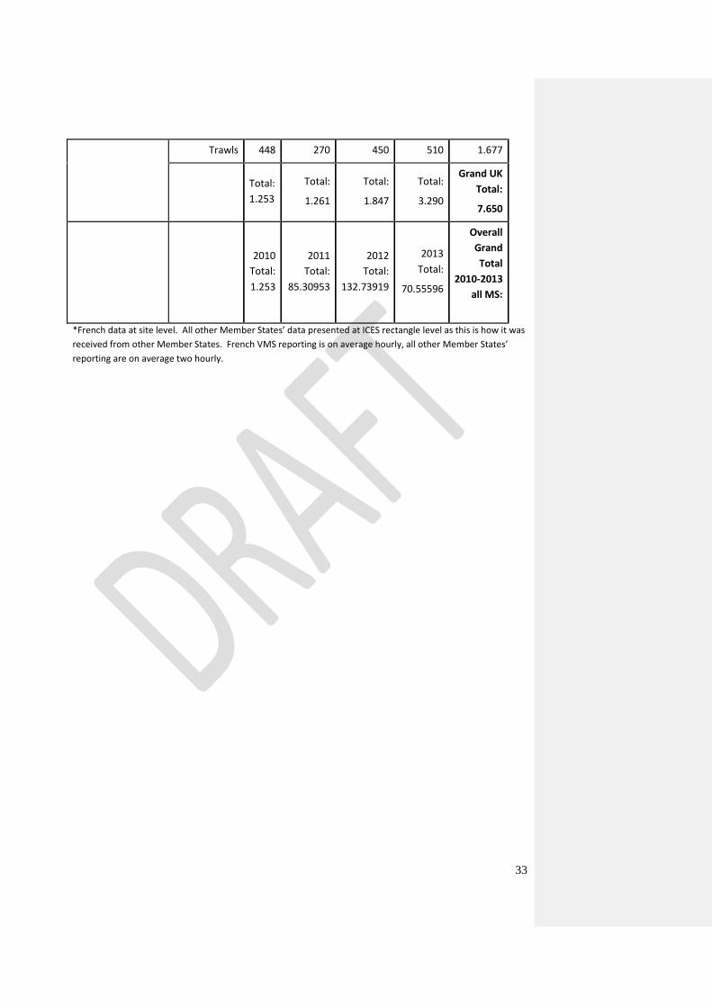
Trawls 448 270 450 510 1.677
Total:
1.253
Total:
1.261
Total:
1.847
Total:
3.290
Grand UK
Total:
7.650
2010
Total:
1.253
2011
Total:
85.30953
2012
Total:
132.73919
2013
Total:
70.55596
Overall
Grand
Total
2010-2013
all MS:
*French data at site level. All other Member States’ data presented at ICES rectangle level as this is how it was
received from other Member States. French VMS reporting is on average hourly, all other Member States’
reporting are on average two hourly.
34
Table 3: Landing values (£) from for vessels operating in Inner Dowsing, Race Bank and North
Ridge SCI by gear type, year and Member State
Member State Gear Code Activity (£) in ICES Rectangle 35FO
2010 2011 2012 2013 Total
Netherlands
Belgium Beam Trawls 0 £13,874.8
9
£8,039.03 £1,602.51 £23,516.43
Total: 0 Total:
£13,874.8
9
Total:
£8,039.03
Total:
£1,602.51
Grand BEL
Total:
£23,516.43
France* Bottom
Trawls
0 £85,553.0
2
£142,309.0
0
£65,090.0
0
£292,952.02
Nets 0 0 0 £165.01 £165.01
Pelagic trawls
0 £732.17 0 £3,906.82 £4,638.98
Total: 0 Total:
£86,285.1
9
Total:
£142,309.0
0
Total:
£69,161.8
3
Grand FRA
Total:
£297,756.01
UK
Dredges £15,436 £213,607 £302,422 £222,962 £754,426
Gill nets and
entangling
nets
£2,600 £1,016 0 0 £3,616
Harvesting
machines 0 £26,497 £266,547 £1,821 £294,865
Hooks and
lines £9,203 £2,678 £2,429 £5,258 £19,568
Miscellaneo
us gear £786,437 £786,437
Traps £1,095,38 £842,665 £699,761 £953,223 £3,591,031
Comment [VM2]: Data missing – MMO currently working with the Dutch on this
35
2
Trawls £897,922 £390,002 £1,116,912 £1,081,49
5 £3,486,330
Total:
£2,020,54
3
Total:
£1,476,46
4
Total:
£2,388,071
Total:
£3,051,19
5
Grand UK
Total:
£8,936,273
Overall
Grand Total
2010-2013
all MS:
£9,257,545.8
7
*France data at site level. All other Member States data is presented at ICES rectangle level as this is how it
was received from other Member States. French VMS reporting is on average hourly, all other Member States’
reporting is on average two hourly
36
5.5 Annual variation in fishing activity
Over the years analysed (2010-2013), the total number of vessels fishing in the Inner Dowsing, Race
Bank and North Ridge SCI were 46 from the UK and 22 from other Member States, making a total of
68. Vessels have been counted more than once if they enter the SCI in separate years. See Table 1
for a breakdown per year.
Numbers of French vessels (between 2 to 7 vessels) has remained fairly stable but low in numbers
over years 2010-2013 with 1 Belgian vessel observed for 1 year and 1 Dutch vessel observed over
two years. French vessels appear to only visit the site during October each year and are not present
at all between December to April.
The UK fishing fleet within the SCI has peaked and troughed twice over the four year period
observed (2010-2013). UK vessels peaked at 16 in years 2010 and 2012 but dropped to 9 vessels in
2011 and 5 in 2013. The reason for this is unknown at this stage.
Fishing effort is indicated by the number of VMS reports at speeds indicative of fishing (from 0 to 6
knots) received by the MMO FMC. Reports are sent by every fishing vessel at 2 hourly intervals, with
the exception of the French VMS activity. This was witnessed at an hourly rate.
Fishing effort within the SCI is considered to be fairly low with the majority of this activity from UK
vessels which peaked at 325 pings in 2011. French vessels in the area travelling between 0-6kts are
also in low numbers and could be contributed to be transiting to a French fishing area just to the
north of the site. French activity appeared to be higher in 2011 and 2012 peaking at 45 pings for
2011 but was significantly lower in 2010 and 2013. Belgian and Dutch activity in the SCI is
considerably low and appears to be rare.
The values (£) and landings (tonnes) effort taken within the SCI vary between each Member State.
UK estimate in total for the four years analysed is 7,650 tonnes with France at 284 tonnes and
Belgium at 5.6 tonnes. The majority of the fishing activity is from the UK fleet (both inshore and
over 15m vessels) and this is also reflected in the values with the UK at £8.9million, France at £297
thousand and Belgium at £23.5 thousand over the four years analysed. The majority of the French
landings and values can be attributed to the fishing activity just north of the site in the Silver Pit as
there are very few French VMS reports from inside the site. The UK values and landings appear to be
very large for this site; this is due to the whole ICES rectangle 35F0 being analysed which also
includes the inshore Wash fishery. The areas of the site which are to be closed to demersal trawls
and dredges, and seines in some areas, has low levels of VMS reports from all UK over 15m vessels
and very low levels from other Member States. The UK inshore fleet do operate in the site but tend
37
to fish outside of the proposed prohibited areas or favour pots and traps over the proposed
prohibited areas to bottom towed gears. Pots and Traps will be allowed to continue in the prohibited
areas.
Danish landings and values data is not displayed as it does not correspond with the SCI site location.
Danish landings and values are attributed to ICES rectangle 35F1 which only covers a very small area
of the site in which there are no reports of Danish vessels reporting. Only Landings and Values from
ICES rectangle 35F0 are displayed as this is where the vast majority of the Inner Dowsing, Race Bank
and North Ridge SCI is. The very small area of the site that enters ICES rectangle 35F1 has very little
to no VMS reports attributed to it; including information from the whole of the ICES rectangle would
therefore skew the results.
There is no historic access to non-UK vessels in the 6nm-12nm area of this SCI. The UK was the only
Member State that reported using seines in the SCI and there was no non-UK seining activity
recorded from 2010-2013.
38
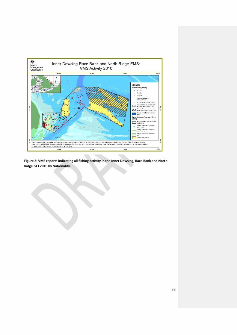
Figure 2: VMS reports indicating all fishing activity in the Inner Dowsing, Race Bank and North
Ridge SCI 2010 by Nationality.
39
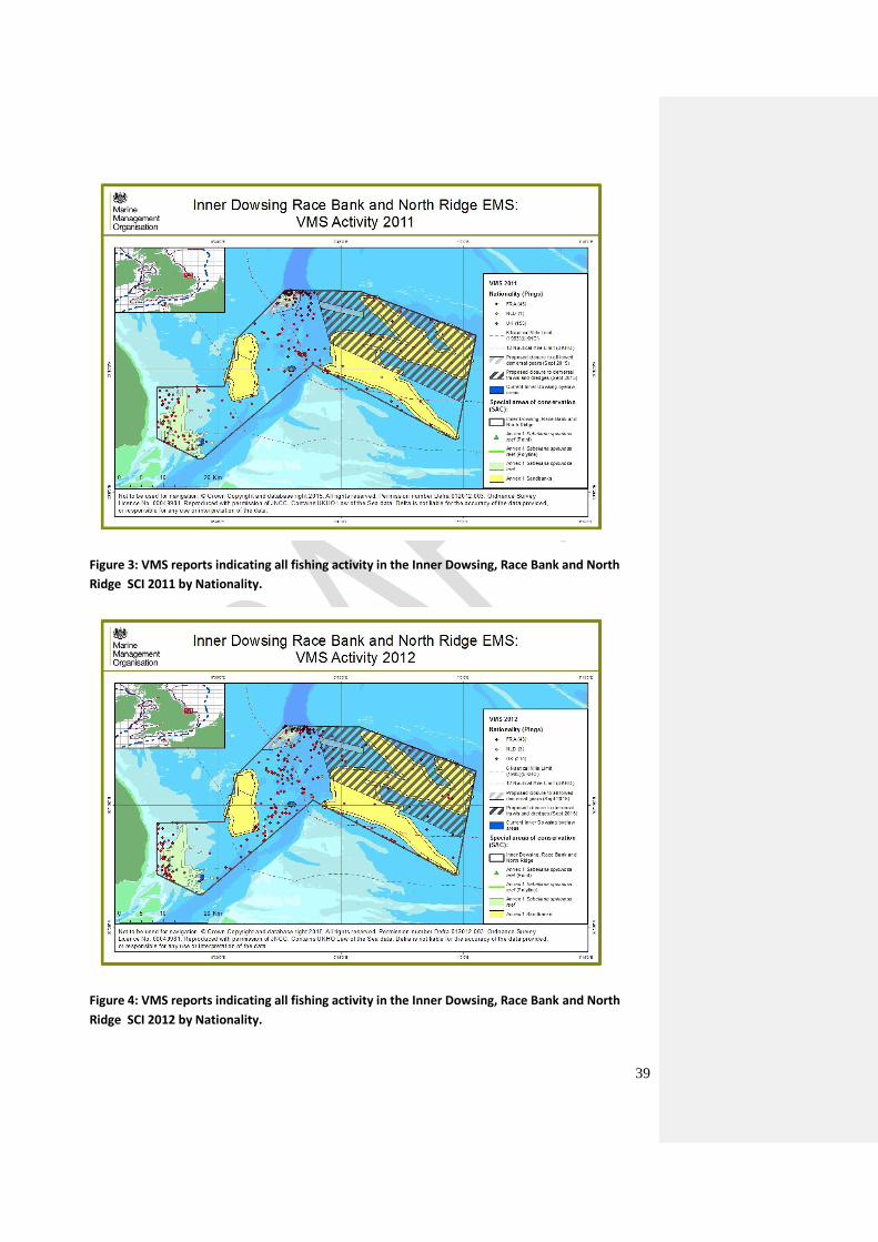
Figure 3: VMS reports indicating all fishing activity in the Inner Dowsing, Race Bank and North
Ridge SCI 2011 by Nationality.
Figure 4: VMS reports indicating all fishing activity in the Inner Dowsing, Race Bank and North
Ridge SCI 2012 by Nationality.
40
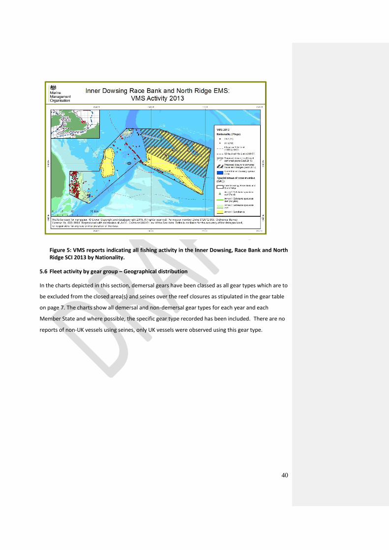
Figure 5: VMS reports indicating all fishing activity in the Inner Dowsing, Race Bank and North Ridge SCI 2013 by Nationality.
5.6 Fleet activity by gear group – Geographical distribution
In the charts depicted in this section, demersal gears have been classed as all gear types which are to
be excluded from the closed area(s) and seines over the reef closures as stipulated in the gear table
on page 7. The charts show all demersal and non-demersal gear types for each year and each
Member State and where possible, the specific gear type recorded has been included. There are no
reports of non-UK vessels using seines, only UK vessels were observed using this gear type.
41
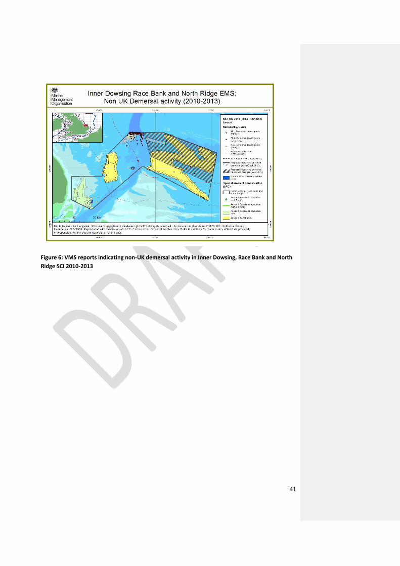
Figure 6: VMS reports indicating non-UK demersal activity in Inner Dowsing, Race Bank and North
Ridge SCI 2010-2013
42
Figure 7: VMS reports indicating non UK non-demersal activity in Inner Dowsing, Race Bank and
North Ridge SCI 2010 - 2013

43
Figure 8: VMS reports indicating UK demersal, non-demersal and seining activity in Inner Dowsing,
Race Bank and North Ridge SCI 2010-2013
5.7 By-catch
The flatfish fisheries (beam and bottom otter board trawl) land a number of other species as by-
catch(e.g. cod, lemon sole). Where these species are landed these are included in the total gross
landing value statistics. Additional species may also be caught as bycatch but are not landed and
there are no current systematic statistics available for these catch components. With the
introduction of Common Fisheries Policy reform, which includes a landing obligation(namely a ban
on the discard of certain species by certain vessels/within certain circumstances), it could become
possible in the future to collate information on bycatch that could contribute to the overall catch
and landings statistics in certain areas. A ban on demersal fish discards was introduced at the end of
2015, following a discard ban on pelagic fish introduced at the end of 2014, with a ban on discarding
all other quota species by 2016.7
7 http://ec.europa.eu/fisheries/reform/docs/discards_en.pdf
44
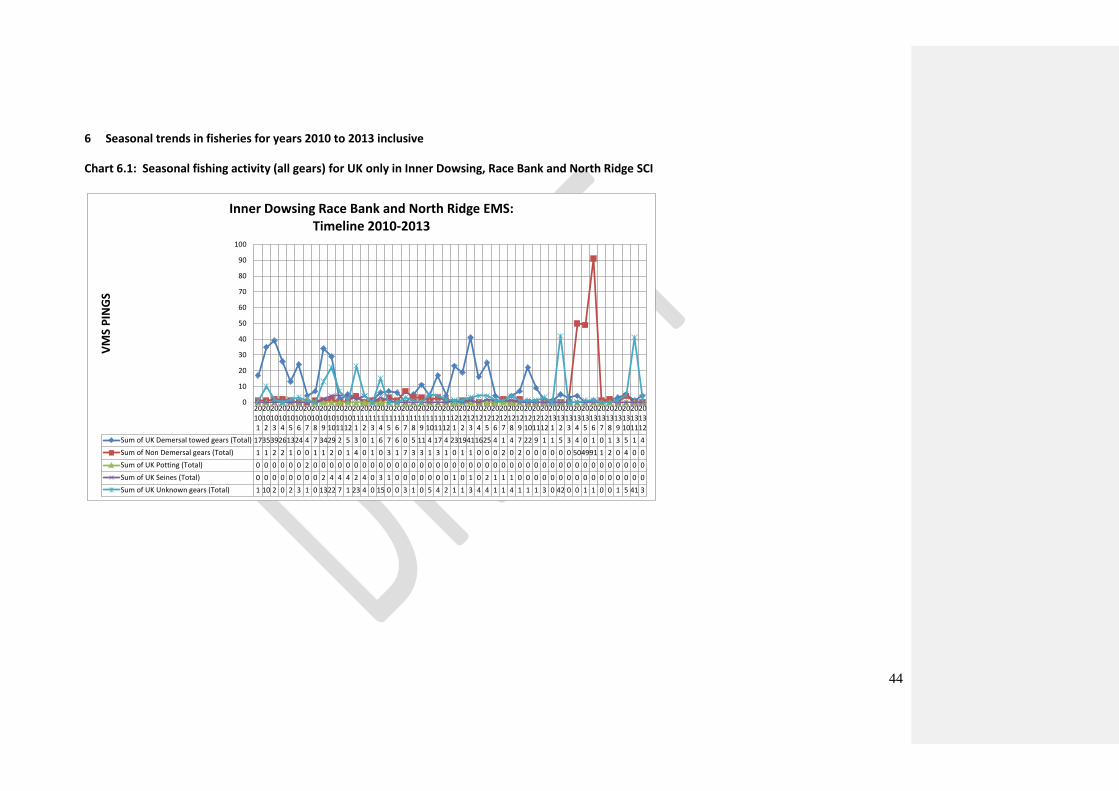
6 Seasonal trends in fisheries for years 2010 to 2013 inclusive
Chart 6.1: Seasonal fishing activity (all gears) for UK only in Inner Dowsing, Race Bank and North Ridge SCI
20101
20102
20103
20104
20105
20106
20107
20108
20109
201010
201011
201012
20111
20112
20113
20114
20115
20116
20117
20118
20119
201110
201111
201112
20121
20122
20123
20124
20125
20126
20127
20128
20129
201210
201211
201212
20131
20132
20133
20134
20135
20136
20137
20138
20139
201310
201311
201312
Sum of UK Demersal towed gears (Total) 173539261324 4 7 3429 2 5 3 0 1 6 7 6 0 5 11 4 17 4 2319411625 4 1 4 7 22 9 1 1 5 3 4 0 1 0 1 3 5 1 4
Sum of Non Demersal gears (Total) 1 1 2 2 1 0 0 1 1 2 0 1 4 0 1 0 3 1 7 3 3 1 3 1 0 1 1 0 0 0 2 0 2 0 0 0 0 0 0 504991 1 2 0 4 0 0
Sum of UK Potting (Total) 0 0 0 0 0 0 2 0 0 0 0 0 0 0 0 0 0 0 0 0 0 0 0 0 0 0 0 0 0 0 0 0 0 0 0 0 0 0 0 0 0 0 0 0 0 0 0 0
Sum of UK Seines (Total) 0 0 0 0 0 0 0 0 2 4 4 4 2 4 0 3 1 0 0 0 0 0 0 0 1 0 1 0 2 1 1 1 0 0 0 0 0 0 0 0 0 0 0 0 0 0 0 0
Sum of UK Unknown gears (Total) 1 10 2 0 2 3 1 0 1322 7 1 23 4 0 15 0 0 3 1 0 5 4 2 1 1 3 4 4 1 1 4 1 1 1 3 0 42 0 0 1 1 0 0 1 5 41 3
0
10
20
30
40
50
60
70
80
90
100
VM
S P
ING
S
Inner Dowsing Race Bank and North Ridge EMS:Timeline 2010-2013

45
Chart 6.2: Seasonal fishing activity (all gears) for OMS only in Inner Dowsing, Race Bank and North
Ridge EMS. To note: OMS activity is very low in this site so it can only be displayed in numerical
form only.
2010 Total
2010
2011 Total
2011
2012 Total
2012
2013 Total
2013
1 2 3 4 5 6 7 8 9 10 11 12 1 2 3 4 5 6 7 8 9 10 11 12 1 2 3 4 5 6 7 8 9 10 11 12 1 2 3 4 5 6 7 8 9 10 11 12
Belgium 0 0 0 0 0 0 1 0 0 0 0 0 1 0 0 0 0 0 0 0 0 0 0 0 0 0 0 0 0 0 0 0 0 0 0 0 0 0 0 0 0 0 0 0 0 0 0 0 0 0 0 0
France 0 0 0 0 0 0 0 2 0 0 0 0 2 0 0 0 0 0 1 1 8 10 18 7 0 45 0 0 0 1 0 0 1 1 5 35 0 0 43 0 0 0 7 0 4 0 9 34 9 0 0 63
Netherlands 0 0 0 0 0 0 0 0 0 0 0 0 0 0 0 0 0 0 0 0 0 1 0 0 0 1 0 0 0 0 0 0 0 3 0 0 0 0 3 0 0 0 0 0 0 0 0 0 0 0 0 0
46
7 Proposed fisheries management measures
7.1 Options for fisheries management measures
A range of management options may be considered, including:
- no additional management required - zoned management - full site prohibition
Activity Management options
Demersal
towed gear
Option 1. No additional management: This option would pose a risk of not
achieving the conservation objectives for sandbanks which are slightly covered by
sea water all the time. The conservation objective for reefs would not be met
under this management option.
Option 2. Reduce/limit pressures: This option would reduce the risk of not
achieving the conservation objectives for the reef and sandbanks which are slightly
covered by sea water all the time.
Appropriate management of reef would include closure of the known extent of the
feature within the sites. Areas to be covered by management restrictions would
include a buffer zone around the known features to reduce any risk of accidental
contact with the feature.
Appropriate management for sandbanks would include closure of a proportion of
the feature’s area to damaging gears, and restrictions on gears that penetrate more
deeply into the sediment. Restrictions could be permanent in some cases or
temporary/adaptive in others. The risks to achieving the conservation objectives
decrease as the size of areas restricting pressure increase.
Option 3. Remove/avoid pressures: This option would reduce the risk of not
achieving the conservation objectives for sandbanks slightly covered by sea water
all the time and reef to the lowest possible levels. Restrictions would be required
for all mobile bottom contact gears within the full extent of the site boundaries.
Demersal
static gear
No additional management: This option is considered unlikely to pose a risk of not
achieving the conservation objectives for sandbanks which are slightly covered by
sea water all the time and reefs. However, if monitoring of condition and fishing
activity showed evidence of detrimental effects as a result of static gear activity in
the future, additional management may be required.
47
7.2 Proposed management option
The exclusion of demersal trawls and dredges in the main management area (in the dark blue
polygon) with two additional sub-zones (in the red polygons) as set out in Figure 1 on page 15
excluding all towed gears including seine netting is the proposed management option, with access to
Silver Pit remaining open for safety navigation reasons.
A buffer zone equal to three times the water depth is applied around the H1170 reef features to
ensure they are protected from accidental incursion from fishing gears.
7.3 Other fisheries measures which apply to the site
There is one MMO byelaw measure within the Inner Dowsing, Race Bank and North Ridge SCI. This
byelaw bans the use of demersal towed fishing gear within three specified areas8. One of these areas
is within the 6-12nm area; there is no other Member State access in the 6-12nm area of the Inner
Dowsing, Race Bank and North Ridge SCI.
8 https://www.gov.uk/government/publications/inner-dowsing-race-bank-and-north-ridge-european-marine-
site-specified-areas-bottom-towed-fishing-gear-byelaw
Reduce/limit pressures: This option would further reduce the risk of not achieving
the conservation objectives for the sandbanks which are slightly covered by sea
water all the time and reef feature. If fishing activity were to rise to levels at which
damage was occurring, appropriate management could include partial closure of
the feature and/or limits on the amount of gear that can be deployed.
48
8 Control measures envisaged by the Member State, possible ecological and control buffer zones to ensure site protection and/or effective control and monitoring measures
8.1 Measures envisaged by Member States for Control, Enforcement and Compliance
The proposed control, enforcement and compliance regime for Inner Dowsing, Race Bank and North
Ridge SCI consists of a combination of at sea surveillance (surface and aerial) and remote monitoring
of vessel position through the establishment of an alert zone (in some form) for the prohibited area
of Inner Dowsing, Race Bank and North Ridge SCI; such a regime would be in line with future control
and enforcement challenges of the Common Fisheries Policy.
8.1.1 Surface and aerial surveillance
Surface and aerial surveillance of Inner Dowsing, Race Bank and North Ridge SCI will be continued
under the existing surveillance plans for the North Sea. These surveillance plans will coordinate the
surface (fisheries protection vessels) and aerial surveillance capacity of the UK.
8.1.2 Increased Reporting Zone
Remote monitoring and surface surveillance will be put in place, targeting Inner Dowsing, Race Bank
and North Ridge SCI in accordance with the MMO’S risk-based MPA management plan.
EU fishing vessels over 12m in length are required to report, through satellite, every two hours.
Reports can be viewed in real time but this reporting frequency would allow vessels to cross the
prohibited area of the SCI without being identified between the two hourly reporting times. The
creation of an increased reporting zone located around the prohibited areas of the site would ensure
that vessels in the vicinity could be identified. Vessels will still be allowed to fish in the increased
reporting zone and increased reporting would provide detailed information on the vessels location in
proximity to the prohibited fishing zone within the site. Vessels will also be allowed to transit the
management area and the increased reporting would allow the MMO FMC to distinguish between
those fishing and those not.
Geofences9 can be set up, using vessel’s VMS devices, which would trigger higher frequency
reporting if a vessel enters the increased reporting zone. It may be possible to increase the
9 A geofence is a spatial virtual barrier. Programs that incorporate geofencing allow an administrator to set up
triggers such as increased reporting so when a device enters (or exits) the boundaries defined by the
administrator it performs the trigger and if required a text message or email alert.
49
frequency of satellite reporting, although this would be very expensive and the cost would be borne
by the fishing vessels.
Fishing will not be prohibited in the reporting zone.
8.2 Vessel position monitoring
Monitoring of vessel position is integral to the preferred control, enforcement and compliance plan.
In order to improve monitoring and compliance, fishing vessels within Inner Dowsing, Race Bank and
North Ridge SCI and the reporting zone should be required to carry a system capable of:
Recording high frequency position reports (up to one report per ten minute interval) when within the prohibited area or reporting zone for the site.
Transmitting position reports via GPRS/GSM 10(when available)
When GPRS/GSM signal is not available: storing positions and forwarding stored reports when the signal is available
Transmitting an email and/or text message alert via GPRS/GSM (when signal available) to the flag state and MMO FMC when a vessel enters the reporting zone for the site.
High frequency reporting would end when a vessel leaves the reporting area for the site.
Mobile network signal is not currently widely available for offshore sites; enforcement action using
this system will therefore be retrospective. An enforcement protocol, based on compliance risk, will
be developed to prioritise deployment of at-sea enforcement capabilities.
In the UK, vessels which are fitted with a VMS+ device can meet all the above system requirements.
The VMS+ device is capable of transmitting increased reporting either through satellite or
GPRS/GSM. There is also development work on another device known as I-VMS (inshore vessel
monitoring system), which although designed primarily for the English inshore fleet (those vessels
under 12m in length), can also meet the above requirements. The requirements proposed will allow
other Member States to report depending on the VMS technology that they currently have available
to them either through GPRS/GSM or satellite.
8.3 Key provisions to include in EC regulation to manage the Inner Dowsing, Race Bank and North Ridge SCI
Key provisions which should be included in a EC regulation to facilitate control enforcement and
compliance include:
10
General Packet Radio System (GPRS) and Global System for Mobile communications (GSM): These are types
of mobile phone technology which meet European telecommunications standards.
50
A prohibition on any demersal trawls and dredges being deployed in the management areas
of the SCI.
Establishment of a 3nm (5.556km) increased reporting zone around the proposed closures.
All fishing vessels within these areas shall be required to record or report vessel positions at
a rate of 10 minute intervals. These areas shall be defined by the coordinates displayed in
Annex C.
A requirement for all fishing vessels entering the increased reporting zone to have a system
for recording and reporting vessel position which meets prescribed specifications (see
Section 8.2 for minimal requirements) and is installed and operative. Any fishing vessel
entering the Inner Dowsing, Race Bank and North Ridge SCI or the reporting zone without
such a system will be committing an offence.
A requirement for all fishing vessels transiting the management area carrying prohibited
gears to have all gears on board lashed and stowed.
A requirement for all fishing vessels transiting the management area carrying prohibited
gears to ensure the speed is not less than six knots during transit except in the case of force
majeure or adverse conditions. In such cases the master shall immediately inform the FMC
of the flag Member State which shall then inform the MMO FMC.
The proposal on which gears to prohibit is formulated in terms of Gear Codes in Annex XI in EU
Regulation 404/2011. In general prohibited gear types are demersal trawls and dredges, and seines
in addition over the closed reef areas. Formulation of the regulation requires clear and precise
definitions which distinguish allowed gear types from prohibited gear types. This includes, for trawls
which can be operated both with and without bottom contact, distinguishing between these
different gear riggings (if such a distinction is not feasible, these gears should be prohibited).
Management measures for the site will be periodically reviewed in line with advancements in
technology, specifically the development of improved remote vessel monitoring and gear in/out
technologies.
9 Measures to monitor and assess the maintenance and/or recovery of the features within the site
JNCC is currently leading a research and development programme to develop an integrated system
of monitoring for marine biodiversity across all UK waters. The programme aims to provide a
coherent framework for biodiversity monitoring to meet the requirements of existing and future
monitoring and assessment obligations including those under the Marine Strategy Framework
Directive, Habitats and Birds Directives and the OSPAR Convention. Monitoring and assessment of
protected sites constituting the UK network of Marine Protected Areas, including Natura 2000 sites,
will be an integral part of this programme. Monitoring within Natura sites in UK offshore waters will
51
be based on the principles outlined in the JNCC’s Common Standards Monitoring Guidance (JNCC
2004).
10 Coordination with neighbouring Member States as appropriate
[To be completed as appropriate following consultation]
11 Evaluation of possible displacement of fishing effort and impact on new areas
Because the SCI will be closed for certain gear types, some displacement is likely to happen, both
within the SCIs and outside the SCI.
Displacement is difficult to quantify, and it is impossible to predict where exactly activities will be
displaced to.
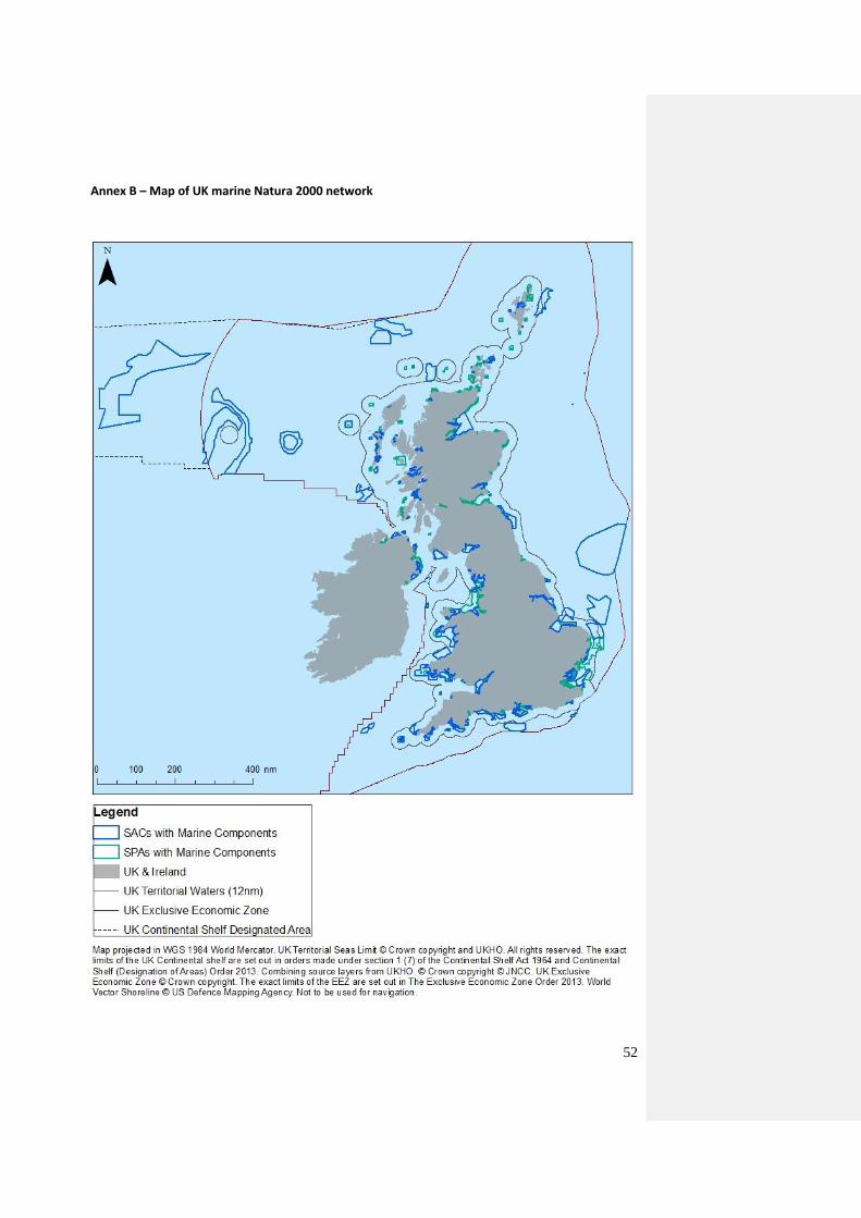
52
Annex B – Map of UK marine Natura 2000 network
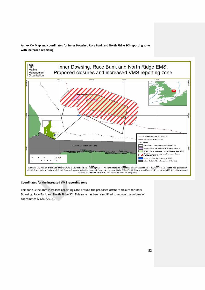
53
Annex C – Map and coordinates for Inner Dowsing, Race Bank and North Ridge SCI reporting zone
with increased reporting
Coordinates for the increased VMS reporting zone
This zone is the 3nm increased reporting zone around the proposed offshore closure for Inner
Dowsing, Race Bank and North Ridge SCI. This zone has been simplified to reduce the volume of
coordinates (21/01/2016).
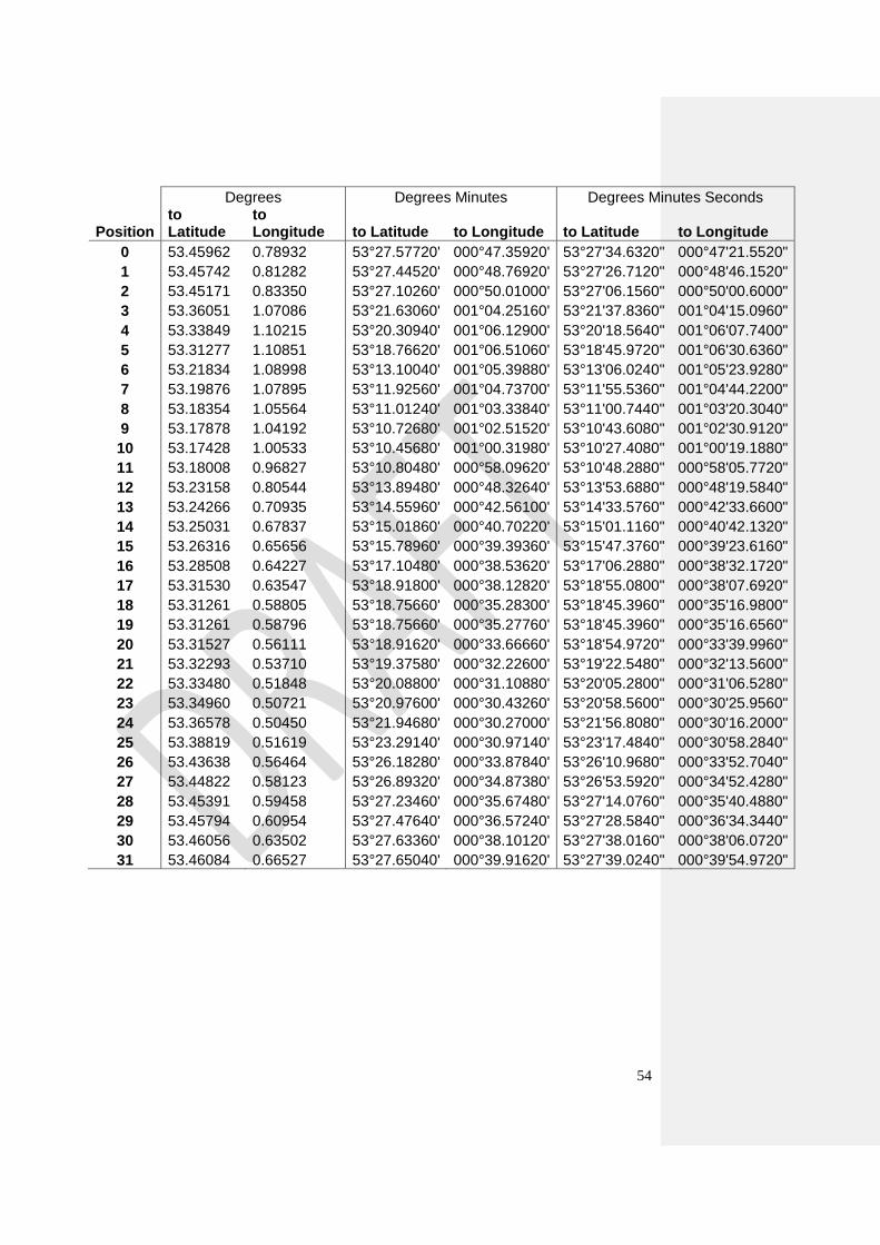
54
Degrees Degrees Minutes Degrees Minutes Seconds
Position to Latitude
to Longitude to Latitude to Longitude to Latitude to Longitude
0 53.45962 0.78932 53°27.57720' 000°47.35920' 53°27'34.6320" 000°47'21.5520"
1 53.45742 0.81282 53°27.44520' 000°48.76920' 53°27'26.7120" 000°48'46.1520"
2 53.45171 0.83350 53°27.10260' 000°50.01000' 53°27'06.1560" 000°50'00.6000"
3 53.36051 1.07086 53°21.63060' 001°04.25160' 53°21'37.8360" 001°04'15.0960"
4 53.33849 1.10215 53°20.30940' 001°06.12900' 53°20'18.5640" 001°06'07.7400"
5 53.31277 1.10851 53°18.76620' 001°06.51060' 53°18'45.9720" 001°06'30.6360"
6 53.21834 1.08998 53°13.10040' 001°05.39880' 53°13'06.0240" 001°05'23.9280"
7 53.19876 1.07895 53°11.92560' 001°04.73700' 53°11'55.5360" 001°04'44.2200"
8 53.18354 1.05564 53°11.01240' 001°03.33840' 53°11'00.7440" 001°03'20.3040"
9 53.17878 1.04192 53°10.72680' 001°02.51520' 53°10'43.6080" 001°02'30.9120"
10 53.17428 1.00533 53°10.45680' 001°00.31980' 53°10'27.4080" 001°00'19.1880"
11 53.18008 0.96827 53°10.80480' 000°58.09620' 53°10'48.2880" 000°58'05.7720"
12 53.23158 0.80544 53°13.89480' 000°48.32640' 53°13'53.6880" 000°48'19.5840"
13 53.24266 0.70935 53°14.55960' 000°42.56100' 53°14'33.5760" 000°42'33.6600"
14 53.25031 0.67837 53°15.01860' 000°40.70220' 53°15'01.1160" 000°40'42.1320"
15 53.26316 0.65656 53°15.78960' 000°39.39360' 53°15'47.3760" 000°39'23.6160"
16 53.28508 0.64227 53°17.10480' 000°38.53620' 53°17'06.2880" 000°38'32.1720"
17 53.31530 0.63547 53°18.91800' 000°38.12820' 53°18'55.0800" 000°38'07.6920"
18 53.31261 0.58805 53°18.75660' 000°35.28300' 53°18'45.3960" 000°35'16.9800"
19 53.31261 0.58796 53°18.75660' 000°35.27760' 53°18'45.3960" 000°35'16.6560"
20 53.31527 0.56111 53°18.91620' 000°33.66660' 53°18'54.9720" 000°33'39.9960"
21 53.32293 0.53710 53°19.37580' 000°32.22600' 53°19'22.5480" 000°32'13.5600"
22 53.33480 0.51848 53°20.08800' 000°31.10880' 53°20'05.2800" 000°31'06.5280"
23 53.34960 0.50721 53°20.97600' 000°30.43260' 53°20'58.5600" 000°30'25.9560"
24 53.36578 0.50450 53°21.94680' 000°30.27000' 53°21'56.8080" 000°30'16.2000"
25 53.38819 0.51619 53°23.29140' 000°30.97140' 53°23'17.4840" 000°30'58.2840"
26 53.43638 0.56464 53°26.18280' 000°33.87840' 53°26'10.9680" 000°33'52.7040"
27 53.44822 0.58123 53°26.89320' 000°34.87380' 53°26'53.5920" 000°34'52.4280"
28 53.45391 0.59458 53°27.23460' 000°35.67480' 53°27'14.0760" 000°35'40.4880"
29 53.45794 0.60954 53°27.47640' 000°36.57240' 53°27'28.5840" 000°36'34.3440"
30 53.46056 0.63502 53°27.63360' 000°38.10120' 53°27'38.0160" 000°38'06.0720"
31 53.46084 0.66527 53°27.65040' 000°39.91620' 53°27'39.0240" 000°39'54.9720"
55
Annex D – References
Bergmann, M.J.N., & Van Santbrink, J.W. (2000). Fishing mortality and populations of megafauna in
sandy sediments. In: Kaiser M.J., & de Groot, S.J. (eds.) Effects of fishing on non-target species and
habitats. Blackwell, Oxford.
Dernie, K.M., Kaiser, M.J., & Warwick, R.M. (2003). Recovery rates of benthic communities following
physical disturbance. Journal of Animal Ecology, 72, 1043 – 1056.
Donaldson, A., Gabriel, C., Harvey, B.J., & Carolsfield, J. (2010). Impacts of fishing gears other than
bottom trawls, dredges, gillnets and longlines on aquatic biodiversity and Vulnerable Marine
Ecosystems. DFO Can. Sci. Advis. Sec. Res. Doc. 2010/011. Vi+84pp.
Eleftheriou, A. and Robertson, M.R. (1992). The effects of experimental scallop dredging on the
fauna and physical environment of a shallow sandy community. Netherlands Journal of Sea Research
30:289-299
Hall, K., Paramor, O.A.L., Robinson, L.A., Winrow-Giffin, A., Frid, C.L.J., Eno, N.C., Dernie, K.M., Sharp,
R.A.M., Wyn, G.C., & Ramsay, K. (2008). Mapping the sensitivity of benthic habitats to fishing in
Welsh waters – development of a protocol. CCW (now Natural Resources Wales) [Policy Research]
Report No: [8/12], 85 pp.
Hiddink, J.G., Jennings, S., Kaiser, M.J., Queirós, A.M., Duplisea, D.E. and Piet G.J. (2006). Cumulative
impacts of seabed trawl disturbance on benthic biomass, production, and species richness in
different habitats. Canadian Journal of Fisheries and Aquatic Science 63: 721–736
Holt, T.J., Rees, E.I., Hawkins, S.J. & Seed, R. (1998). Biogenic reefs (volume IX). An overview of
dynamic and sensitivity characteristics for conservation management of marine SACs. Scottish
Association for Marine Science (UK Marine SACS Project). 170 pp.
JNCC, (2004). Common standards monitoring; introduction to the guidance manual. Peterborough:
JNCC. Available from http://jncc.defra.gov.uk/page-2201
JNCC, (2012). UK guidance on defining boundaries for marine SACs for Annex I habitat sites fully
detached from the coast. Peterborough: JNCC. Available from:
http://jncc.defra.gov.uk/pdf/SACHabBoundaryGuidance_2012Update.pdf
Jones, L.A., Hiscock, K., & Connor, D.W. (2000). Marine habitat review. A summary of ecological
requirements and sensitivity characteristics for the conservation and management of marine SACs.
Peterborough: Joint Nature Conservation Committee. (UK Marine SACs Project report).
Kaiser, M.J., Clarke, K.R., Hinz, H., Austen, M.C.V., Somerfield P.J. & Karakassis, I. (2006). Global
analysis of response and recovery of benthic biota to fishing. Marine Ecology Progress Series, 311, 1–
14.
Klein, A., (2006). Identification of submarine banks in the North Sea and the Baltic Sea with the aid of
TIN modelling. In: VON NORDHEIM, H., BOEDEKER, D. & KRAUSE, J.C. (Eds.). Progress in Marine
Conservation in Europe. Natura 2000 Sites in German Offshore Waters. Springer, Berlin, Heidelberg,
New York, pp. 97-110.
56
OSPAR. (2010). Quality status report 2010. Case reports for the OSPAR list of threatened and/or
declining species and habitats update. Available from:
http://qsr2010.ospar.org/media/assessments/Species/p0010_supplements/CH10_04_Sabellaria_spi
nulosa.pdf
Tillin, H.M., Hull, S.C., & Tyler-Walters, H. (2010). Development of a sensitivity matrix (pressures-
MCZ/MPA features). Report to the Department of the Environment, Food and Rural Affairs from
ABPMer, Southampton and the Marine Life Information Network (MarLIN) Plymouth: Marine
Biological Association o the UK. Defra Contract No: MB102 Task 3a, Report No 22
Suuronen, P., Chopin, F., Glass, C., Løkkeborg, S., Matsushita, Y., Queirolo, D., & Rihan, D. (2012).
Low impact and fuel efficient fishing – looking beyond the horizon. Fisheries Research. 119-120: 135-
146.
UK Biodiversity Action Plan. (2000). UK Biodiversity Group Tranche 2 action plans. Volume V –
maritime species and habitats. Peterborough: English Nature (now Natural England), 242 pp.
Vorberg, R. (2000). Effects of shrimp fisheries on reefs of Sabellaria spinulosa (Polychaeta). ICES
Journal of Marine Science, 57: 1416-1420.
Recommended