Conservation Management Zones of AustraliaSouth Western Australia Temperate Forests
Prepared by the Department of the Environment

Conservation Management Zones of Australia, South Western Australia Temperate Forests
AcknowledgementsThis project and its associated products are the result of collaboration between the Department of the Environment’s Biodiversity Conservation Division and the Environmental Resources Information Network (ERIN). Invaluable input, advice and support were provided by staff and leading researchers from across the Department of Environment (DotE), Department of Agriculture (DoA), the Commonwealth Scientific and Industrial Research Organisation (CSIRO) and the academic community. We would particularly like to thank staff within the Wildlife, Heritage and Marine Division, Parks Australia and the Environment Assessment and Compliance Division of DotE; Nyree Stenekes and Robert Kancans (DoA), Sue McIntyre (CSIRO), Richard Hobbs (University of Western Australia), Michael Hutchinson (ANU); David Lindenmayer and Emma Burns (ANU); and Gilly Llewellyn, Martin Taylor and other staff from the World Wildlife Fund for their generosity and advice.
Special thanks to CSIRO researchers Kristen Williams and Simon Ferrier whose modelling of biodiversity patterns underpinned identification of the Conservation Management Zones of Australia.
Image CreditsFront Cover: Karri Forest at Boranup – PlatoursPage 4: D’Entrecasteaux National Park, near Windy Harbour – Tourism Western AustraliaPage 10: Whale, near Busselton – David AshleyPage 14: Sugarloaf Rock, Cape Naturaliste – Georgina Steytler, www.wildandendangered.com.auPage 15: Numbat (Myrmecobius fasciatus) – Georgina Steytler, www.wildandendangered.com.auPage 16: Red-capped Parrot (Purpureicephalus spurius) – Georgina Steytler, www.wildandendangered.com.auPage 17: Canal Rocks, south of Yallingup – Tourism Western AustraliaPage 18: Red-tailed Phascogale (Phascogale calura) – Babs and Bert Wells (CALM)Page 21: Quokka (Setonix brachyurus), Rottnest Island – Georgina Steytler, www.wildandendangered.com.auPage 23: Baudins Black-Cockatoo (Calyptorhynchus baudinii) – Georgina Steytler, www.wildandendangered.com.auPage 24: Rainbow Bee-Eater (Merops ornatus) – Georgina Steytler, www.wildandendangered.com.auPage 30: Noisy Scrub-bird, Tjimiluk (Atrichornis clamosus) – Allan RosePage 34: Boranup State Forest, Margaret River – Tourism Western AustraliaPage 35: Blue Tinsel Lily (Calectasia cyanea) – Murray FaggPage 36: Eucalyptus open forests with a shrubby understorey (Eucalyptus marginata) – Neil RichesPage 37: Eucalyptus woodlands with a shrubby understorey (Eucalyptus wandoo) – Georgina Steytler, www.wildandendangered.com.auPage 38: Eucalyptus tall open forest with a fine-leaved shrubby understorey (Eucalyptus marginata) – SleepcreatureBack Cover: Karri Forest at Boranup – Platours
© Commonwealth of Australia, 2015.
The Conservation Management Zones of Australia profile is licensed by the Commonwealth of Australia for use under a Creative Commons By Attribution 3.0 Australia licence with the exception of the Coat of Arms of the Commonwealth of Australia, the logo of the agency responsible for publishing the report, content supplied by third parties, and any images depicting people.
For licence conditions see here.

Conservation Management Zones of Australia, South Western Australia Temperate Forests
Contents
Acknowledgement of Traditional Owners and Country ����������������������������������������������2
Introduction ���������������������������������������������������������������������������������������������������������������������������������2
Zone at a glance �������������������������������������������������������������������������������������������������������������������������3
Population characteristics �������������������������������������������������������������������������������������������������������6
Employment, volunteering and incomes ��������������������������������������������������������������������������9
Agriculture, Natural Resource Management practices and sources of NRM advice ��������������������������������������������������������������������������������������������������11
Land tenure, land use, Native Title and Local Government Areas ������������������������� 13
Zone vegetation characteristics����������������������������������������������������������������������������������������� 15
Ramsar and Nationally Important Wetlands�������������������������������������������������������������������17
World and National Heritage ���������������������������������������������������������������������������������������������� 18
Major National Reserve System properties �������������������������������������������������������������������� 19
EPBC Act (1999) threatened ecological communities ������������������������������������������������� 20
EPBC Act (1999) threatened species ��������������������������������������������������������������������������������� 21
EPBC Act (1999) migratory species ������������������������������������������������������������������������������������ 27
Threatened endemic species ���������������������������������������������������������������������������������������������� 29
Invasive species ����������������������������������������������������������������������������������������������������������������������� 32
Vegetation profiles and management recommendations ��������������������������������������� 35

2 / Conservation Management Zones of Australia, South Western Australia Temperate Forests
The Australian Government acknowledges Australia’s Traditional Owners and pays respect to Elders past and present of our nation’s Aboriginal and Torres Strait Islander communities� We honour the deep spiritual, cultural and customary connections of Traditional Owners to the Australian landscape, including Australia’s waterways, land and sea country�
Introduction The 23 Conservation Management Zones of Australia are geographic areas, classified according to their ecological and threat characteristics. The zones are also aligned with the Interim Biogeographic Regionalisation of Australia.
The Conservation Management Zones provide a way of understanding Australia’s natural environment that will assist in long-term conservation planning and help the Australian Government to better design, deliver and report on Natural Resource Management (NRM) investments, including ensuring alignment of national NRM priorities with local action.
The Conservation Management Zones also provide a filter through which to make national environmental and socio-economic data more accessible and comprehensible, and a framework for gathering on-ground knowledge and expertise about the environment. This will improve information flow to the Australian Government about regional NRM requirements, best practice management, emerging NRM issues and knowledge gaps.
The Conservation Management Zones do not represent any change to existing administrative boundaries or governance structures, but aim to support the NRM and wider community to cooperatively manage environmental assets across boundaries, where they share common threats, ecological characteristics and stakeholders.
Each Conservation Management Zone profile contains a standard suite of nationally available ecological and socio-economic information. We hope that this information will enable Australians of all ages and backgrounds to engage with, understand and appreciate Australian landscapes, and support all Australians to manage our natural resources more effectively.
The profile information provides an indicative, high-level stock-take of the environmental and socio-economic landscape and it is not intended to be comprehensive. It should also be noted that, at present, the profiles contain only limited information on aquatic ecosystems, coastal assets and Indigenous land management practices. In future, consultation and comprehensive literature reviews will enable us to provide more complete information.
Acknowledgement of Traditional Owners and Country

3 / Conservation Management Zones of Australia, South Eastern Australia Temperate Woodlands
Zone at a glance
Area of zone: 5,353,845 hectares
% of Australia:
0.70%3.65 people per square kilometre
Population density:
Zone population characteristics
0
50,000
100,000
150,000
200,000
190,194
Tota
l
Engl
ish a
s a
seco
nd
lang
uage
Indi
geno
us
Ove
r 65
Yout
h (1
5–24
)
Num
ber o
f peo
ple
Zone employment characteristics
97.1%
UnemployedEmployed
2.9%
Source: Based on Australian Bureau of Statistics data

4 / Conservation Management Zones of Australia, South Western Australia Temperate Forests
Regional centres Population
Albany 33,650
Bridgetown 1,518
Collie 6,994
Denmark 2,291
Donnybrook 2,236
Dunsborough 1,708
Manjimup 4,172
Margaret River 5,313
Mount Barker 1,794
Perth (outskirts) 62,273
Natural Resource Management (NRM) regions
Southwest Catchments Council Inc WA
South Coast NRM Inc WA
Peel Harvey Catchment Council WA
Perth Region NRM WA
Wheatbelt NRM Council Inc WA
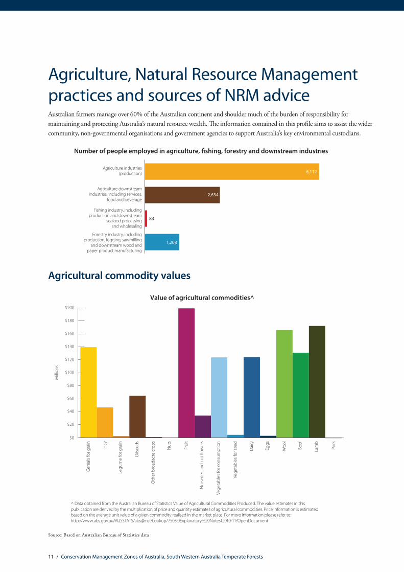
Top five agricultural commodities Value (millions)
Fruit $199
Lamb $172
Wool $165
Cereals for grain $139
Beef $130Total value of agricultural commodities (including other commodities not listed here)
$1,294
Climate characteristics*
Mean annual temperature 15.2 Celsius
Mean Maximum of the Hottest Month 28.4 Celsius
Mean Minimum of the Coldest Month 5.6 Celsius
Mean Annual Rainfall 824.3 mm
Dominant rainfall season Winter
* The figures are interpolated 75-year means (1921 to 1995) representing the period prior to the onset of rapid climatic warming. Cited in: Williams KJ, Belbin L, Austin MP, Stein J, Ferrier S (2012) Which environmental variables should I use in my biodiversity model? International Journal of Geographic Information Sciences 26(11), 2009–2047. (Data derived from Australian Climate surfaces version 2.1 for the ANUCLIM-BIOCLIM package).
For future climate projections please refer to: http://www.climatechangeinaustralia.gov.au/
Source: Based on Australian Bureau of Statistics data
5 / Conservation Management Zones of Australia, South Western Australia Temperate Forests
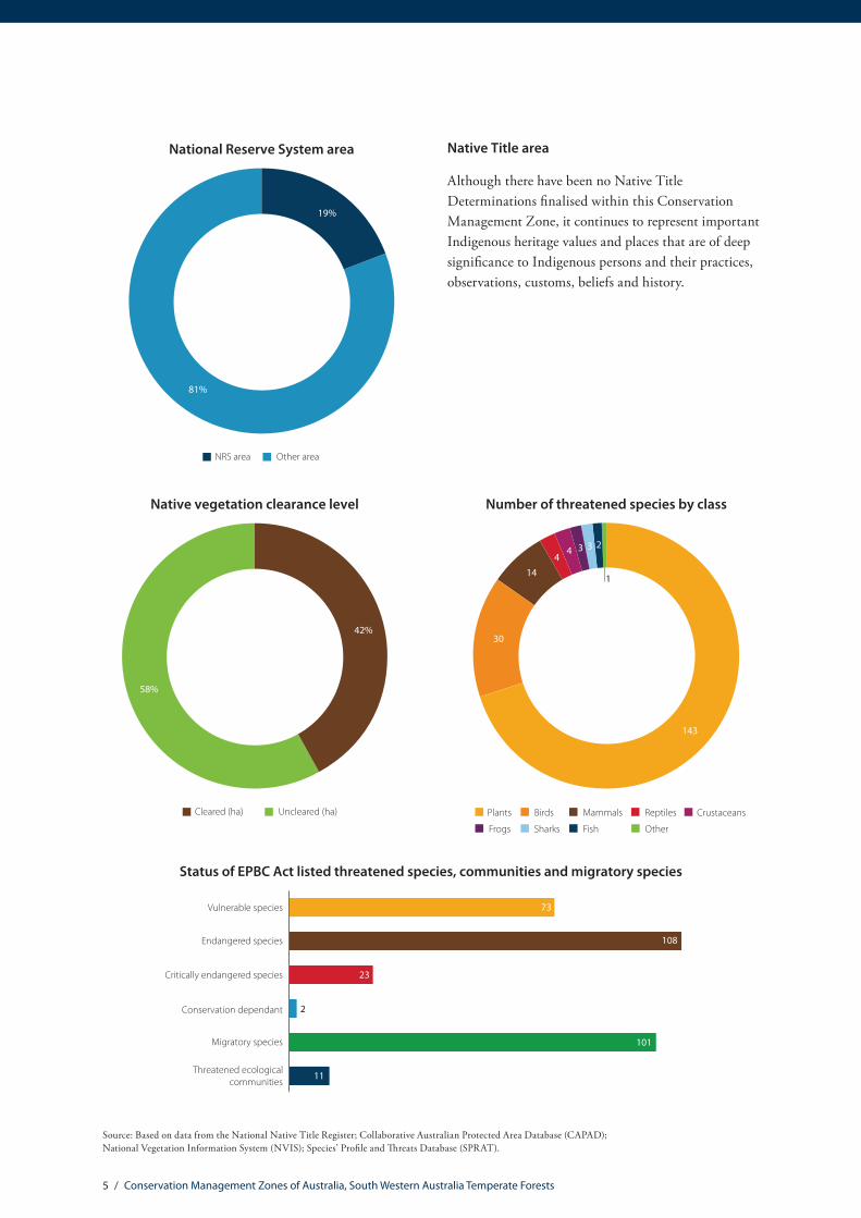
National Reserve System area
81%
19%
Other areaNRS area
Native Title area
Although there have been no Native Title Determinations finalised within this Conservation Management Zone, it continues to represent important Indigenous heritage values and places that are of deep significance to Indigenous persons and their practices, observations, customs, beliefs and history.
Native vegetation clearance level
58%
42%
Uncleared (ha)Cleared (ha)
Number of threatened species by class
143
30
14
4 3
Frogs
CrustaceansBirdsPlants Mammals
Sharks
Reptiles
Fish Other
1
43 2
Status of EPBC Act listed threatened species, communities and migratory species
0 22 44 66 88 110
73
23
2
8
11
Conservation dependant
Critically endangered species
Migratory species
Threatened ecologicalcommunities
Endangered species
Vulnerable species
101
108
Source: Based on data from the National Native Title Register; Collaborative Australian Protected Area Database (CAPAD); National Vegetation Information System (NVIS); Species’ Profile and Threats Database (SPRAT).

6 / Conservation Management Zones of Australia, South Western Australia Temperate Forests
Population
Population by age group
20%
12%
38%
65 years and over40–64 years
15–24 years0–14 years 25–39 years
15%
15%
Indigenous population by age group
33%
21%
22%
22%
65 years and over40–64 years
15–24 years0–14 years 25–39 years
2%
Farmer and farm managers by age group
17%
2%
22%
59%
65 years and over40–64 years
25–39 years15–24 years
Gender of farmers and farm managers
3,413
1,446
FemaleMale
Source: Based on Australian Bureau of Statistics data
Population characteristics
7 / Conservation Management Zones of Australia, South Western Australia Temperate Forests
Source: Based on Australian Bureau of Statistics data
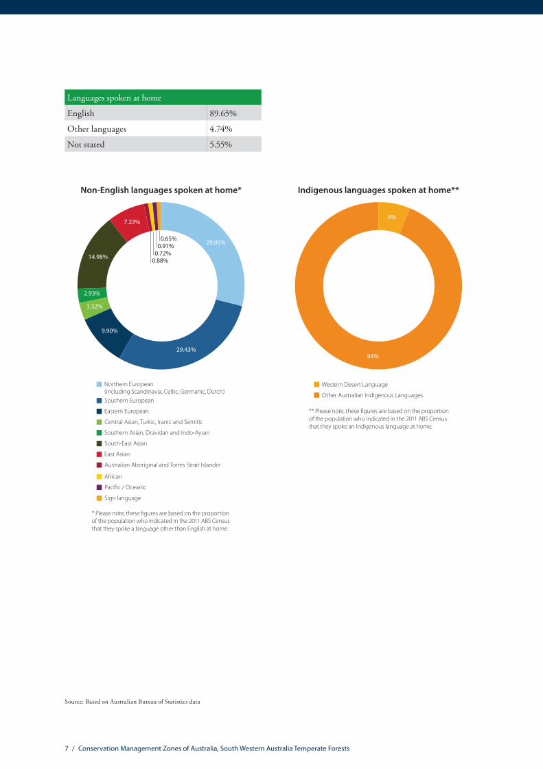
Languages spoken at home
English 89.65%
Other languages 4.74%
Not stated 5.55%
Non-English languages spoken at home*
Northern European (including Scandinavia, Celtic, Germanic, Dutch)Southern European
Eastern European
Central Asian, Turkic, Iranic and Semitic
Southern Asian, Dravidan and Indo-Ayran
South-East Asian
East Asian
Australian Aboriginal and Torres Strait Islander
African
Paci�c / Oceanic
Sign language
7.23%
29.05%
2.93%
9.90%
0.65%0.91%0.72%0.88%
* Please note, these �gures are based on the proportion of the population who indicated in the 2011 ABS Census that they spoke a language other than English at home.
29.43%
3.32%
14.98%
Indigenous languages spoken at home**
6%
94%
Western Desert Language
Other Australian Indigenous Languages
** Please note, these �gures are based on the proportion of the population who indicated in the 2011 ABS Census that they spoke an Indigenous language at home.

8 / Conservation Management Zones of Australia, South Western Australia Temperate Forests
Education
0%
5%
10%
15%
20%
25%
30%
35%
40%
45%
65 years and over40–64 years
25–39 years15–24 years
Highest level of educational attainment – total population
Inad
equa
tely
des
crib
ed/N
ot st
ated
No
Educ
atio
nal A
ttai
nmen
t
Scho
ol Y
ears
10
or b
elow
Scho
ol Y
ears
11
and
12
Cert
i�ca
te L
evel
Bach
elor
Deg
ree/
Adva
nced
Dip
lom
a an
d D
iplo
ma
Post
grad
uate
Deg
ree/
Gra
duat
eD
iplo
ma
& G
radu
ate
Cert
i�ca
te
Highest level of educational attainment – Indigenous community
0%
5%
10%
15%
20%
25%
30%
35%
40%
Inad
equa
tely
des
crib
ed/N
ot st
ated
No
Educ
atio
nal A
ttai
nmen
t
Scho
ol Y
ears
10
or b
elow
Scho
ol Y
ears
11
and
12
Cert
i�ca
te L
evel
Bach
elor
Deg
ree/
Adva
nced
Dip
lom
a an
d D
iplo
ma
Post
grad
uate
Deg
ree/
Gra
duat
eD
iplo
ma
& G
radu
ate
Cert
i�ca
te
65 years and over40–64 years
25–39 years15–24 years
0%
10%
20%
30%
40%
50%
60%
65 years and over40–64 years
25–39 years15–24 years
Highest level of educational attainment – farmers and farm managers
Inad
equa
tely
des
crib
ed/N
ot st
ated
No
Educ
atio
nal A
ttai
nmen
t
Scho
ol Y
ears
10
or b
elow
Scho
ol Y
ears
11
and
12
Cert
i�ca
te L
evel
Bach
elor
Deg
ree/
Adva
nced
Dip
lom
a an
d D
iplo
ma
Post
grad
uate
Deg
ree/
Gra
duat
eD
iplo
ma
& G
radu
ate
Cert
i�ca
te
0
1,000
2,000
3,000
4,000
5,000
6,000
7,000
8,000
9,000
10,000
Post-school quali�cation types*
15–2
4 ye
ars o
ld
25–3
9 ye
ars o
ld
40–6
4 ye
ars o
ld
65 y
ears
an
d ab
ove
Natural and Physical Sciences
Agriculture, Environmental and Related Studies
Health and education
Architecture, building, society and culture and creative arts
Information Technology, Management and Commerce and service industries
* Please note, this table omits quali�cations of mixed �eld, quali�cations that are not adequately described, and information relating to census respondents who have not stated their quali�cation or are not applicable (i.e. Not of age to have post-school quali�cation).
Source: Based on Australian Bureau of Statistics data

9 / Conservation Management Zones of Australia, South Western Australia Temperate Forests
Employment
0%
10%
20%
30%
40%
50%
60%
70%
80%
90%
Employment status of general population*
65 y
ears
and
abov
e
15–2
4 ye
ars o
ld
40–6
4 ye
ars o
ld
25–3
9 ye
ars o
ld
Employed
Unemployed
Not in labour force or not stated
* Please note the % �gures are relative to each of the age groupings of the population. The categories above are aggregates of the following Australian Bureau of Statistics categories: Employed = Employed full-time; Employed part-time; and Employed away from work. Unemployed = Unemployed looking for full-time work; and Unemployed looking for part-time work. Not in the Labour Force or Not Stated = Not in the Labour Force; and Not Stated. Please note the ‘not applicable’ category has been omitted from the analysis. Not applicable applies to the proportion of the population that is not of working age (e.g. 0–15 year olds and retired). ABS 2011 Census Labour Force data has been utilised for this report, as the national quarterly employment �gures are derived from a relatively small sample of the population.
Employment by industry
Agriculture, forestry and sheries
Mining
Manufacturing
Utilities, construction and transport
Health, Social Assistance, Education and training
Public administration and safety
Wholesale and retail trade
Services
Food, accommodation, arts and recreation
Unknown/not stated
8%
16%
9%
18%6%
13%
16%
5%
7% 2%
0%
10%
20%
30%
40%
50%
60%
70%
80%
90%
Employment status of general population*
65 y
ears
and
abov
e
15–2
4 ye
ars o
ld
40–6
4 ye
ars o
ld
25–3
9 ye
ars o
ld
Employed
Unemployed
Not in labour force or not stated
* Please note the % �gures are relative to each of the age groupings of the population. The categories above are aggregates of the following Australian Bureau of Statistics categories: Employed = Employed full-time; Employed part-time; and Employed away from work. Unemployed = Unemployed looking for full-time work; and Unemployed looking for part-time work. Not in the Labour Force or Not Stated = Not in the Labour Force; and Not Stated. Please note the ‘not applicable’ category has been omitted from the analysis. Not applicable applies to the proportion of the population that is not of working age (e.g. 0–15 year olds and retired). ABS 2011 Census Labour Force data has been utilised for this report, as the national quarterly employment �gures are derived from a relatively small sample of the population.
0%
10%
20%
30%
40%
50%
60%
70%
80%
90%
Employment status of Indigenous population*
Indi
geno
us65
yea
rsan
d ab
ove
Indi
geno
us15
–24
year
s old
Indi
geno
us40
–64
year
s old
Indi
geno
us25
–39
year
s old
Employed
Unemployed
Not in labour force or not stated
Source: Based on Australian Bureau of Statistics data
Employment, volunteering and incomes

10 / Conservation Management Zones of Australia, South Western Australia Temperate Forests
Volunteering
0%
10%
20%
30%
40%
50%
60%
70%
80%
Volunteering rates
15–2
4 ye
ars o
ld
25–3
9 ye
ars o
ld
40–6
4 ye
ars o
ld
65 y
ears
an
d ab
ove
Not a volunteer
Volunteer
Not stated or not applicable
Income
Total household income (% of households)*
19.4%
46.9%
13%
5.5%
15.2%
Over $104,000
Under $20,800
Not Stated/Partially Stated
$20,800–64,999 $65,000–$103,999
* Please note these �gures have been derived from the ABS Equivalised Total Household Income (HIED)Census 2011 data. ABS data categories have been aggregated for the purposes of this report. For more information see: http://www.abs.gov.au/websitedbs/censushome.nsf/home/statementsdwellinghied?opendocument&navpos=430
In the 2011–12 �nancial year, persons who earned $67,500 or less were eligible for Low Income Tax O�set. Human Services applied the following de�nitions of “low income” as eligibility criteria for the Low Income Supplement in the 2012–13 �nancial year: Income below $30,000 for singles, $45,000 combined for couples, or $60,000 combined for couples or singles with a dependent child.
Source: Based on Australian Bureau of Statistics data
11 / Conservation Management Zones of Australia, South Western Australia Temperate Forests
Agricultural commodity values
Value of agricultural commodities^
$0
$20
$40
$60
$80
$100
$120
$140
$160
$180
$200
Oth
er b
road
acre
cro
ps
Nut
s
Frui
t
Oils
eeds
Legu
me
for g
rain
Hay
Cere
als f
or g
rain
Eggs
Woo
l
Beef
Lam
b
Pork
Dai
ry
Vege
tabl
es fo
r see
d
Vege
tabl
es fo
r con
sum
ptio
n
Nur
serie
s and
cut
�ow
ers
Mill
ions
^ Data obtained from the Australian Bureau of Statistics Value of Agricultural Commodities Produced. The value estimates in this publication are derived by the multiplication of price and quantity estimates of agricultural commodities. Price information is estimated based on the average unit value of a given commodity realised in the market place. For more information please refer to: http://www.abs.gov.au/AUSSTATS/[email protected]/Lookup/7503.0Explanatory%20Notes12010-11?OpenDocument
Source: Based on Australian Bureau of Statistics data
Agriculture, Natural Resource Management practices and sources of NRM adviceAustralian farmers manage over 60% of the Australian continent and shoulder much of the burden of responsibility for maintaining and protecting Australia’s natural resource wealth. The information contained in this profile aims to assist the wider community, non-governmental organisations and government agencies to support Australia’s key environmental custodians.
Number of people employed in agriculture, �shing, forestry and downstream industries
6,112
2,634
204
79
83Forestry industry, including
production, logging, sawmillingand downstream wood and
paper product manufacturing
Fishing industry, includingproduction and downstream
seafood processingand wholesaling
Agriculture downstreamindustries, including services,
food and beverage
Agriculture industries (production)
1,208
83
12 / Conservation Management Zones of Australia, South Western Australia Temperate Forests
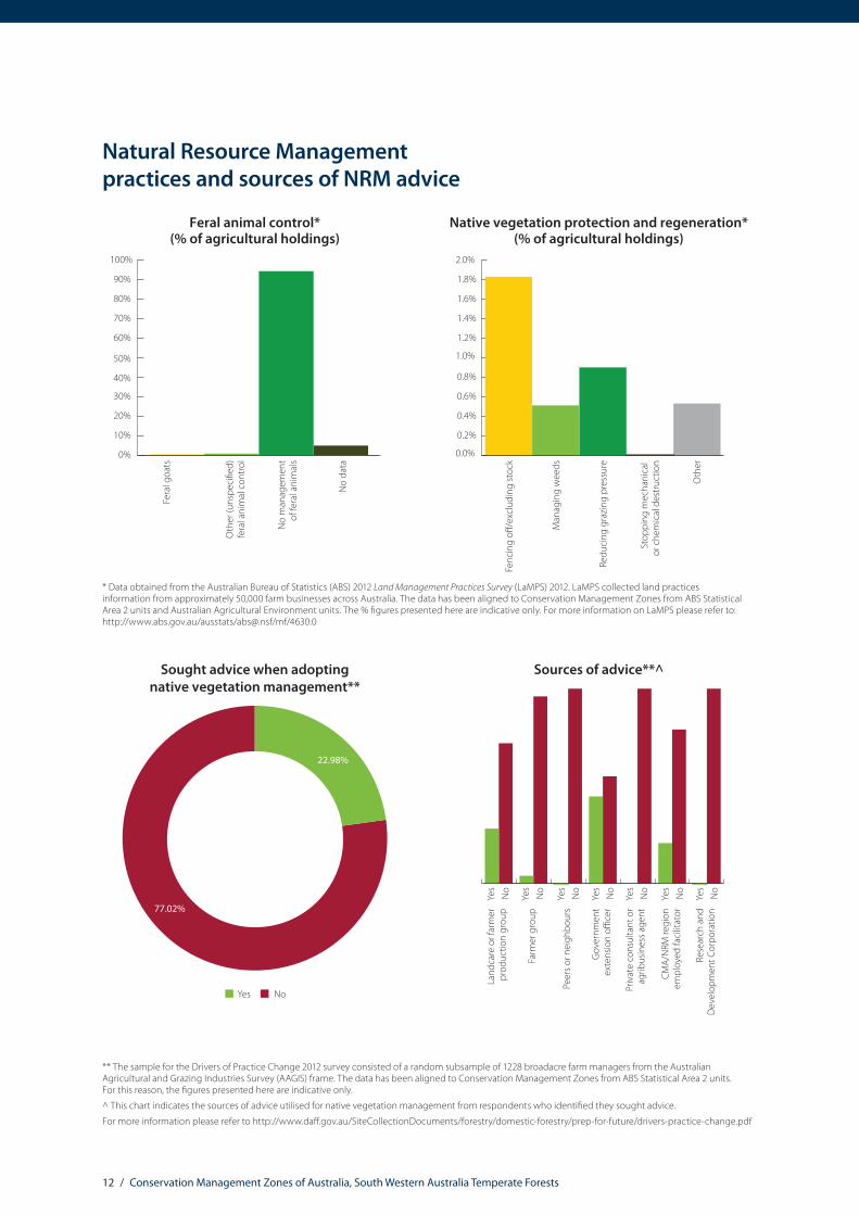
Natural Resource Management practices and sources of NRM advice
0%
10%
20%
30%
40%
50%
60%
70%
80%
90%
100%
Feral animal control*(% of agricultural holdings)
No
man
agem
ent
of fe
ral a
nim
als
Oth
er (u
nspe
ci�e
d)fe
ral a
nim
al c
ontr
ol
Fera
l goa
ts
No
data
0.0%
0.2%
0.4%
0.6%
0.8%
1.0%
1.2%
1.4%
1.6%
1.8%
2.0%
Native vegetation protection and regeneration*(% of agricultural holdings)
Oth
er
Stop
ping
mec
hani
cal
or c
hem
ical
des
truc
tion
Redu
cing
gra
zing
pre
ssur
e
Man
agin
g w
eeds
Fenc
ing
o�/e
xclu
ding
stoc
k
Sought advice when adopting native vegetation management**
77.02%
22.98%
NoYes
Sources of advice**^
Yes
No
Yes
No
Yes
No
Yes
No
Yes
No
Yes
No
Yes
No
Priv
ate
cons
ulta
nt o
rag
ribus
ines
s age
nt
CMA/
NRM
regi
onem
ploy
ed fa
cilit
ator
Rese
arch
and
Dev
elop
men
t Cor
pora
tion
Gov
ernm
ent
exte
nsio
n o�
cer
Peer
s or n
eigh
bour
s
Farm
er g
roup
Land
care
or f
arm
erpr
oduc
tion
grou
p
** The sample for the Drivers of Practice Change 2012 survey consisted of a random subsample of 1228 broadacre farm managers from the Australian Agricultural and Grazing Industries Survey (AAGIS) frame. The data has been aligned to Conservation Management Zones from ABS Statistical Area 2 units. For this reason, the figures presented here are indicative only.
^ This chart indicates the sources of advice utilised for native vegetation management from respondents who identified they sought advice.
For more information please refer to http://www.daff.gov.au/SiteCollectionDocuments/forestry/domestic-forestry/prep-for-future/drivers-practice-change.pdf
* Data obtained from the Australian Bureau of Statistics (ABS) 2012 Land Management Practices Survey (LaMPS) 2012. LaMPS collected land practices information from approximately 50,000 farm businesses across Australia. The data has been aligned to Conservation Management Zones from ABS Statistical Area 2 units and Australian Agricultural Environment units. The % figures presented here are indicative only. For more information on LaMPS please refer to: http://www.abs.gov.au/ausstats/[email protected]/mf/4630.0
13 / Conservation Management Zones of Australia, South Western Australia Temperate Forests
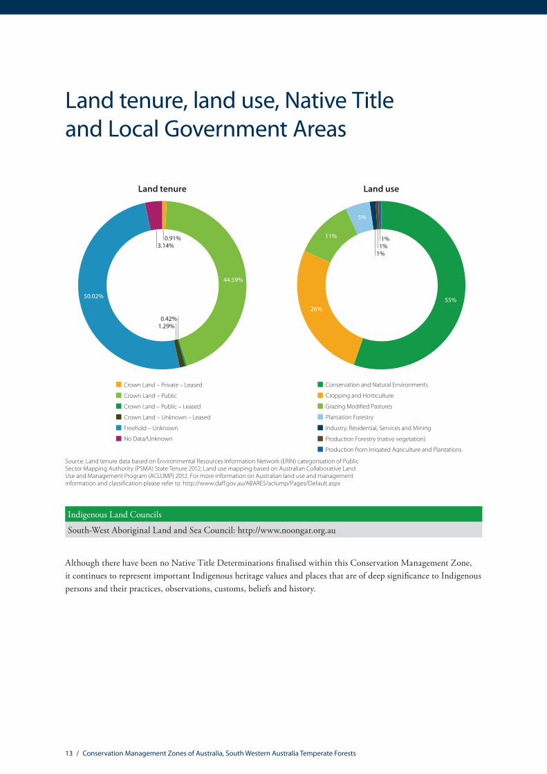
Land tenure, land use, Native Title and Local Government Areas
Land tenure
Crown Land – Private – Leased
Crown Land – Public
Crown Land – Public – Leased
Crown Land – Unknown – Leased
Freehold – Unknown
No Data/Unknown
44.59%
0.91%3.14%
50.02%
1.29%0.42%
Land use
Conservation and Natural Environments
Cropping and Horticulture
Grazing Modi�ed Pastures
Plantation Forestry
Industry, Residential, Services and Mining
Production Forestry (native vegetation)
Production from Irrigated Agriculture and Plantations
55%
11% 1%1%
1%
26%
5%
Source: Land tenure data based on Environmental Resources Information Network (ERIN) categorisation of Public Sector Mapping Authority (PSMA) State Tenure 2012; Land use mapping based on Australian Collaborative Land Use and Management Program (ACLUMP) 2012. For more information on Australian land use and management information and classification please refer to: http://www.daff.gov.au/ABARES/aclump/Pages/Default.aspx
Indigenous Land Councils
South-West Aboriginal Land and Sea Council: http://www.noongar.org.au
Although there have been no Native Title Determinations finalised within this Conservation Management Zone, it continues to represent important Indigenous heritage values and places that are of deep significance to Indigenous persons and their practices, observations, customs, beliefs and history.

14 / Conservation Management Zones of Australia, South Western Australia Temperate Forests
Local Government Areas
City Of Albany WA
City Of Armadale WA
City Of Busselton WA
City Of Gosnells WA
City Of Swan WA
Shire Of Augusta-Margaret River WA
Shire Of Beverley WA
Shire Of Boddington WA
Shire Of Boyup Brook WA
Shire Of Bridgetown-Greenbushes WA
Shire Of Brookton WA
Shire Of Broomehill-Tambellup WA
Shire Of Capel WA
Shire Of Chittering WA
Shire Of Collie WA
Shire Of Cranbrook WA
Shire Of Cuballing WA
Shire Of Dardanup WA
Shire Of Denmark WA
Shire Of Donnybrook-Balingup WA
Shire Of Gingin WA
Shire Of Harvey WA
Local Government Areas
Shire Of Kalamunda WA
Shire Of Katanning WA
Shire Of Kojonup WA
Shire Of Manjimup WA
Shire Of Moora WA
Shire Of Mundaring WA
Shire Of Murray WA
Shire Of Nannup WA
Shire Of Narrogin WA
Shire Of Northam WA
Shire Of Pingelly WA
Shire Of Plantagenet WA
Shire Of Serpentine-Jarrahdale WA
Shire Of Toodyay WA
Shire Of Victoria Plains WA
Shire Of Wagin WA
Shire Of Wandering WA
Shire Of Waroona WA
Shire Of West Arthur WA
Shire Of Williams WA
Shire Of Woodanilling WA
Shire Of York WA

15 / Conservation Management Zones of Australia, South Western Australia Temperate Forests
Zone vegetation characteristics
Major Vegetation Subgroups (MVS) with >1% original distribution within zone
Eucalyptusopen forests with
a shrubby understorey
Eucalyptuswoodlands with a
shrubby understorey
Melaleucaopen forests
and woodlands
Other shrublands Eucalyptus tallopen forest with a
�ne-leaved shrubbyunderstorey
0%
10%
20%
30%
40%
50%
60%
Present day percentage of CMZ areaPre 1750 percentage of CMZ area

16 / Conservation Management Zones of Australia, South Western Australia Temperate Forests
The National Vegetation Information System (NVIS) framework is a nationally consistent vegetation classification system based on vegetation data collected by states and territories. It provides information on the extent and distribution of vegetation types across the Australian landscape.
Two products are used to provide the Zone Vegetation Characteristics graph. A modelled pre-European vegetation distribution (pre-1750), and extant (current extent) vegetation, which is based on contemporary vegetation mapping. The information presented here relates to Major Vegetation Subgroups (MVSs). There are 85 MVS types across Australia, describing the structure and floristic composition of dominant and secondary vegetation stratums (e.g. canopy and mid-storey species). Major Vegetation Subgroups only reflect the dominant vegetation type occurring in an area from a mix of vegetation types. Less-dominant vegetation groups which may also be present are therefore not represented.
It is important to note that the vegetation information is indicative only, as state and territory mapping in Australia is of variable resolution and scale. However, this data is the best available nationally consistent information on vegetation, and the dataset continues to evolve and increase in accuracy.
Analysing this information at Conservation Management Zone, rather than national level provides greater discrimination for decision makers, as clearance levels of vegetation types are not uniform across Australia. For example, eucalypt woodlands with a tussock grass understory is a vegetation type found across Australia. In the Brigalow Woodlands Conservation Management Zone, eucalypt open woodlands with a tussock grass understory originally covered approximately 36% of the zone, but today it only covers only 14.5 % of the zone (58.7% of this vegetation community has been cleared in the Brigalow). In the Northern Australia Tropical Savannah zone, this vegetation type originally occupied 19.6% of the zone. Today, it occupies approximately 19.4% of the zone (only 2.3% of this vegetation type has been cleared). It should be noted that this data only provides an indication of change in extent, and not vegetation condition.
For more information on the National Vegetation Information System (NVIS) please refer to: http://www.environment.gov.au/topics/science-and-research/databases-and-maps/national-vegetation-information-system

17 / Conservation Management Zones of Australia, South Western Australia Temperate Forests
The National Vegetation Information System (NVIS) framework is a nationally consistent vegetation classification system based on vegetation data collected by states and territories. It provides information on the extent and distribution of vegetation types across the Australian landscape.
Two products are used to provide the Zone Vegetation Characteristics graph. A modelled pre-European vegetation distribution (pre-1750), and extant (current extent) vegetation, which is based on contemporary vegetation mapping. The information presented here relates to Major Vegetation Subgroups (MVSs). There are 85 MVS types across Australia, describing the structure and floristic composition of dominant and secondary vegetation stratums (e.g. canopy and mid-storey species). Major Vegetation Subgroups only reflect the dominant vegetation type occurring in an area from a mix of vegetation types. Less-dominant vegetation groups which may also be present are therefore not represented.
It is important to note that the vegetation information is indicative only, as state and territory mapping in Australia is of variable resolution and scale. However, this data is the best available nationally consistent information on vegetation, and the dataset continues to evolve and increase in accuracy.
Analysing this information at Conservation Management Zone, rather than national level provides greater discrimination for decision makers, as clearance levels of vegetation types are not uniform across Australia. For example, eucalypt woodlands with a tussock grass understory is a vegetation type found across Australia. In the Brigalow Woodlands Conservation Management Zone, eucalypt open woodlands with a tussock grass understory originally covered approximately 36% of the zone, but today it only covers only 14.5 % of the zone (58.7% of this vegetation community has been cleared in the Brigalow). In the Northern Australia Tropical Savannah zone, this vegetation type originally occupied 19.6% of the zone. Today, it occupies approximately 19.4% of the zone (only 2.3% of this vegetation type has been cleared). It should be noted that this data only provides an indication of change in extent, and not vegetation condition.
For more information on the National Vegetation Information System (NVIS) please refer to: http://www.environment.gov.au/topics/science-and-research/databases-and-maps/national-vegetation-information-system
Ramsar wetlands Jurisdiction Hectares
Muir-Byenup System WA 10,639
Ramsar and Nationally Important Wetlands
Nationally important wetlands are defined according to the following criteria:1. It is a good example of a wetland type occurring within a biogeographic region in Australia.2. It is a wetland which plays an important ecological or hydrological role in the natural functioning of a major wetland system/complex.3. It is a wetland which is important as the habitat for animal taxa at a vulnerable stage in their life cycles, or provides a refuge when
adverse conditions such as drought prevail.4. The wetland supports 1% or more of the national populations of any native plant or animal taxa.5. The wetland supports native plant or animal taxa or communities which are considered endangered or vulnerable at the national level.6. The wetland is of outstanding historical or cultural significance.Please note, the above are a subset of all the Nationally Important Wetlands found within the Zone. For more information on Nationally Important Wetlands please see: http://www.environment.gov.au/resource/directory-important-wetlands-australia-third-edition
Nationally Important Wetlands Jurisdiction Hectares CriteriaAvon River Valley WA 0.12 6Blackwood River (Lower Reaches) and Tributaries System WA 325.08 1, 3, 4, 5, 6
Broke Inlet System WA 5,118.44 1, 2, 3, 6Byenup Lagoon System WA 10,347.44 1, 2, 3, 4, 5, 6Chittering-Needonga Lakes WA 225.78 1, 2, 3, 4, 6Doggerup Creek System WA 16,052.39 1, 2, 3, 4, 6Gingilup-Jasper Wetland System WA 2,766.05 1, 2, 3, 4, 6Lake Muir WA 3,993.94 1, 2, 3, 4, 5, 6Lake Pleasant View System WA 436.70 1, 3, 6Maringup Lake WA 274.35 1, 2, 4, 6Moates Lake System WA 474.07 1, 3, 4, 6Mt Soho Swamps WA 331.85 4, 6Owingup Swamp System WA 906.70 1, 2, 3, 4, 6Oyster Harbour WA 1,580.50 1, 2, 3, 6Wannamal Lake System WA 177.49 2, 3, 4, 5, 6
For more information on Ramsar please refer to: http://www.environment.gov.au/topics/water/water-our-environment/wetlands/ramsar-convention-wetlands
18 / Conservation Management Zones of Australia, South Western Australia Temperate Forests
Please refer to the Australian Heritage Database for detailed information on listing criteria for these heritage values: http://www.environment.gov.au/topics/heritage/publications-and-resources/australian-heritage-database
For more information on Australia’s world and national heritage please refer to: http://www.environment.gov.au/topics/heritage/about-australias-heritage
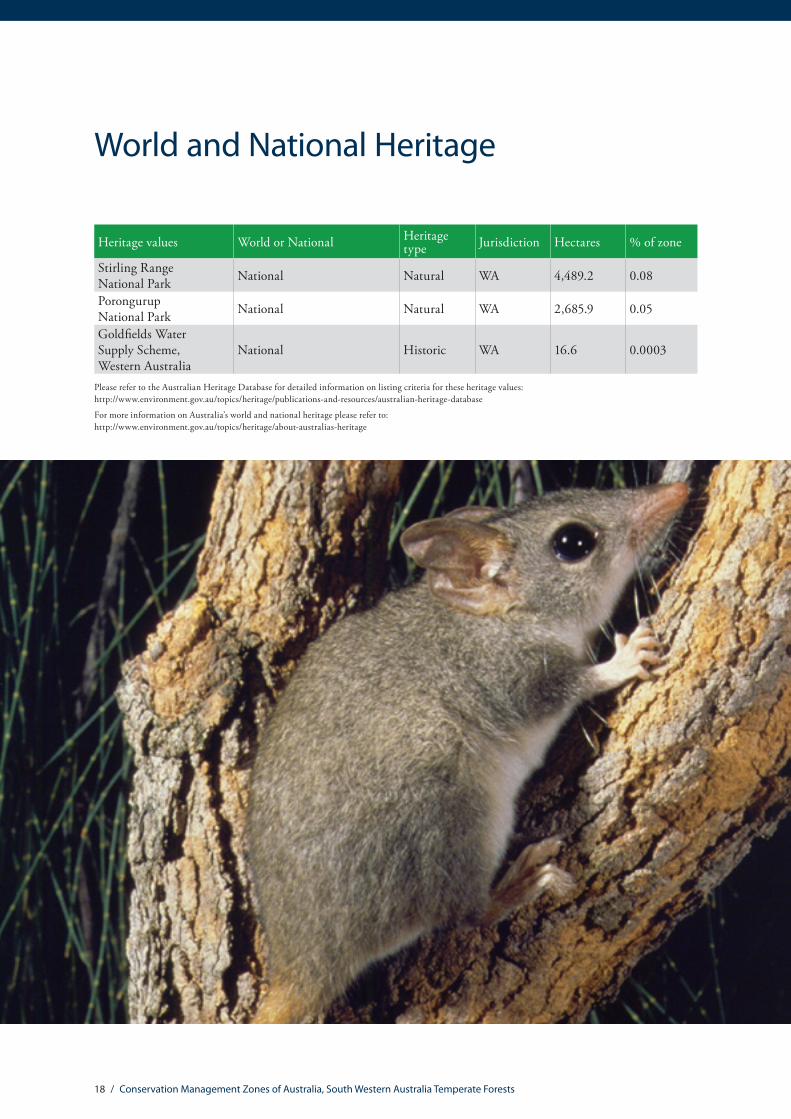
World and National Heritage
Heritage values World or National Heritage type Jurisdiction Hectares % of zone
Stirling Range National Park National Natural WA 4,489.2 0.08
Porongurup National Park National Natural WA 2,685.9 0.05
Goldfields Water Supply Scheme, Western Australia
National Historic WA 16.6 0.0003

19 / Conservation Management Zones of Australia, South Western Australia Temperate Forests
Major National Reserve System properties
Major National Reserve System properties
Name Property type IUCN category Jurisdiction Hectares % of zone
Mt Roe National Park II WA 127,800 2.39
D’Entrecasteaux National Park II WA 118,089 2.21
Tone-Perup Nature Reserve IA WA 55,974 1.05
Shannon National Park II WA 52,622 0.98
Wandoo National Park II WA 46,375 0.87
Mt Frankland South National Park II WA 42,294 0.79
Mt Lindesay National Park II WA 39,573 0.74
Mount Frankland National Park II WA 37,122 0.69
Lane Poole Reserve 5(1)(g) Reserve II WA 29,541 0.55
Mt Frankland North National Park II WA 22,070 0.41
Leeuwin-Naturaliste National Park II WA 21,761 0.41
Greater Kingston National Park II WA 21,114 0.39
Blackwood River National Park II WA 20,487 0.38
Greater Beedelup National Park II WA 19,287 0.36
Milyeannup National Park II WA 18,698 0.35
Wellington National Park II WA 17,431 0.33
Hilliger National Park II WA 16,986 0.32Monadnocks Conservation Park 5(1)(g) Reserve II WA 15,519 0.29
Walpole-Nornalup National Park II WA 14,858 0.28
Greater Hawke National Park II WA 14,008 0.26
The IUCN categories are as follows:
Ia Strict Nature Reserve IUCN protected area management categories classify protected areas according to their management objectives. The categories are recognised by international bodies such as the United Nations and are utilised by many national governments, including the Australian Government, as the global standard for defining and recording protected areas.
Ib Wilderness Area
II National Park
III Natural Monument or Feature
IV Habitat/Species Management Area
V Protected Landscape/ Seascape
VI Protected area with sustainable use of natural resources
Please refer to the IUCN website for further explanation: http://www.iucn.org/about/work/programmes/gpap_home/gpap_quality/gpap_pacategories/
For more information on Australia’s National Reserve System please refer to: http://www.environment.gov.au/topics/land/national-reserve-system
Source: Collaborative Australian Protected Area Database 2012.

20 / Conservation Management Zones of Australia, South Western Australia Temperate Forests
EPBC Act (1999) threatened ecological communitiesThreatened ecological communities
Name Listing status % of total distribution* % of zone**
Aquatic Root Mat Community 1 in Caves of the Leeuwin Naturaliste Ridge Endangered 100 0.005
Aquatic Root Mat Community 2 in Caves of the Leeuwin Naturaliste Ridge Endangered 100 0.005
Aquatic Root Mat Community 3 in Caves of the Leeuwin Naturaliste Ridge Endangered 100 0.005
Aquatic Root Mat Community 4 in Caves of the Leeuwin Naturaliste Ridge Endangered 100 0.005
Scott River Ironstone Association Endangered 100 0.013
Shrublands on southern Swan Coastal Plain ironstones Endangered 36.76 0.002
Shrublands and Woodlands of the eastern Swan Coastal Plain Endangered 22.98 0.002
Claypans of the Swan Coastal Plain Critically Endangered 5.2 0.008
Corymbia calophylla – Kingia australis woodlands on heavy soils of the Swan Coastal Plain Endangered 3 0.001
Proteaceae Dominated Kwongkan Shrublands of the Southeast Coastal Floristic Province of Western Australia Endangered 0.22 0.049
Corymbia calophylla – Xanthorrhoea preissii woodlands and shrublands of the Swan Coastal Plain Endangered 0.09 0.00002
* % of the total national distribution describes the proportion of the total national distribution of the Threatened Ecological Community that is found within the zone.
** % of the total zone area describes the proportion of the zone that the Threatened Ecological Community is likely or known to occur in.
It should be noted that the identification of any given Threatened Ecological Community above does not imply that the Threatened Ecological Community (TEC) is found uniformly across the Conservation Management Zone. Rather, the % of the TEC’s total distribution (*) within the zone is an indication of its importance to that zone in terms of conservation efforts. The % of the zone (**) indicates how rare, or difficult the ecological community may be to find within the zone.
The threatened ecological communities above are listed under The Environment Protection and Biodiversity Conservation Act 1999 (EPBC Act), which is the Australian Government’s principal environmental legislation. For more information, please refer to http://www.environment.gov.au/biodiversity/threatened/communities

21 / Conservation Management Zones of Australia, South Western Australia Temperate Forests
EPBC Act (1999) threatened species
Threatened mammals
Common name Scientific name Status % of total distribution*
% of zone**
Quokka Setonix brachyurus Vulnerable 100 0.02
Gilbert’s Potoroo Potorous gilbertii Critically Endangered 99.97 0.03
Western Ringtail Possum Pseudocheirus occidentalis Vulnerable 75.65 15.30
Woylie Bettongia penicillata ogilbyi Endangered 56.59 7.85
Chuditch, Western Quoll Dasyurus geoffroii Vulnerable 32.2 99.28
Red-tailed Phascogale Phascogale calura Endangered 31.9 7.68
Numbat Myrmecobius fasciatus Vulnerable 21.14 2.18
Black-flanked Rock-wallaby Petrogale lateralis lateralis Vulnerable 9.25 0.66
Dibbler Parantechinus apicalis Endangered 0.64 0.18
Greater Bilby Macrotis lagotis Vulnerable 0.01 0.28
Blue Whale Balaenoptera musculus Endangered n/a n/a
Southern Right Whale Eubalaena australis Endangered n/a n/a
Australian Sea-lion Neophoca cinerea Vulnerable n/a n/a
Humpback Whale Megaptera novaeangliae Vulnerable n/a n/a
22 / Conservation Management Zones of Australia, South Western Australia Temperate Forests
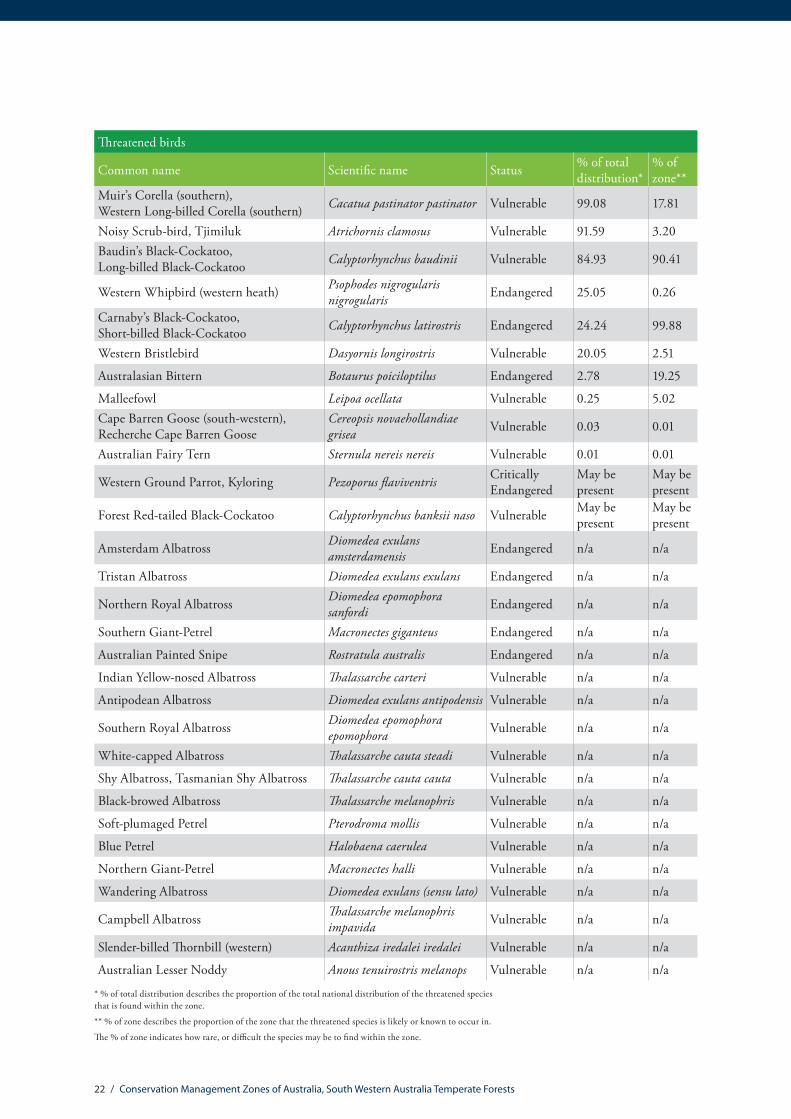
Threatened birds
Common name Scientific name Status % of total distribution*
% of zone**
Muir’s Corella (southern), Western Long-billed Corella (southern) Cacatua pastinator pastinator Vulnerable 99.08 17.81
Noisy Scrub-bird, Tjimiluk Atrichornis clamosus Vulnerable 91.59 3.20Baudin’s Black-Cockatoo, Long-billed Black-Cockatoo Calyptorhynchus baudinii Vulnerable 84.93 90.41
Western Whipbird (western heath) Psophodes nigrogularis nigrogularis Endangered 25.05 0.26
Carnaby’s Black-Cockatoo, Short-billed Black-Cockatoo Calyptorhynchus latirostris Endangered 24.24 99.88
Western Bristlebird Dasyornis longirostris Vulnerable 20.05 2.51
Australasian Bittern Botaurus poiciloptilus Endangered 2.78 19.25
Malleefowl Leipoa ocellata Vulnerable 0.25 5.02Cape Barren Goose (south-western), Recherche Cape Barren Goose
Cereopsis novaehollandiae grisea Vulnerable 0.03 0.01
Australian Fairy Tern Sternula nereis nereis Vulnerable 0.01 0.01
Western Ground Parrot, Kyloring Pezoporus flaviventris Critically Endangered
May be present
May be present
Forest Red-tailed Black-Cockatoo Calyptorhynchus banksii naso Vulnerable May be present
May be present
Amsterdam Albatross Diomedea exulans amsterdamensis Endangered n/a n/a
Tristan Albatross Diomedea exulans exulans Endangered n/a n/a
Northern Royal Albatross Diomedea epomophora sanfordi Endangered n/a n/a
Southern Giant-Petrel Macronectes giganteus Endangered n/a n/a
Australian Painted Snipe Rostratula australis Endangered n/a n/a
Indian Yellow-nosed Albatross Thalassarche carteri Vulnerable n/a n/a
Antipodean Albatross Diomedea exulans antipodensis Vulnerable n/a n/a
Southern Royal Albatross Diomedea epomophora epomophora Vulnerable n/a n/a
White-capped Albatross Thalassarche cauta steadi Vulnerable n/a n/a
Shy Albatross, Tasmanian Shy Albatross Thalassarche cauta cauta Vulnerable n/a n/a
Black-browed Albatross Thalassarche melanophris Vulnerable n/a n/a
Soft-plumaged Petrel Pterodroma mollis Vulnerable n/a n/a
Blue Petrel Halobaena caerulea Vulnerable n/a n/a
Northern Giant-Petrel Macronectes halli Vulnerable n/a n/a
Wandering Albatross Diomedea exulans (sensu lato) Vulnerable n/a n/a
Campbell Albatross Thalassarche melanophris impavida Vulnerable n/a n/a
Slender-billed Thornbill (western) Acanthiza iredalei iredalei Vulnerable n/a n/a
Australian Lesser Noddy Anous tenuirostris melanops Vulnerable n/a n/a
* % of total distribution describes the proportion of the total national distribution of the threatened species that is found within the zone.
** % of zone describes the proportion of the zone that the threatened species is likely or known to occur in.
The % of zone indicates how rare, or difficult the species may be to find within the zone.

23 / Conservation Management Zones of Australia, South Western Australia Temperate Forests
Threatened reptiles
Common Name Scientific name Status % of total distribution*
% of zone**
Loggerhead Turtle Caretta caretta Endangered n/a n/a
Leatherback Turtle, Leathery Turtle, Luth Dermochelys coriacea Endangered n/a n/a
Green Turtle Chelonia mydas Vulnerable n/a n/a
Flatback Turtle Natator depressus Vulnerable n/a n/a

24 / Conservation Management Zones of Australia, South Western Australia Temperate Forests
Other threatened fauna
Common name Scientific name Status % of total distribution*
% of zone**
Hairy Marron, Margaret River Hairy Marron, Margaret River Marron Cherax tenuimanus Critically
Endangered 100 0.004
Margaret River Burrowing Crayfish Engaewa pseudoreducta Critically Endangered 100 0.0002
Spotted Galaxias (western subspecies), Western Spotted Galaxias, Western Trout Galaxias
Galaxias truttaceus hesperius Critically Endangered 100 0.16
Walpole Burrowing Crayfish Engaewa walpolea Endangered 100 0.11
Sunset Frog Spicospina flammocaerulea Endangered 100 1.66
White-bellied Frog, Creek Frog Geocrinia alba Endangered 100 0.40
Balston’s Pygmy Perch Nannatherina balstoni Vulnerable 100 0.10
Orange-bellied Frog Geocrinia vitellina Vulnerable 100 0.06
Dunsborough Burrowing Crayfish Engaewa reducta Critically Endangered 79.41 0.10
Shield-backed Trapdoor Spider, Black Rugose Trapdoor Spider Idiosoma nigrum Vulnerable 0.21 0.28
Grey Nurse Shark (west coast population) Carcharias taurus Vulnerable n/a n/a
Great White Shark Carcharodon carcharias Vulnerable n/a n/a
Whale Shark Rhincodon typus Vulnerable n/a n/a

25 / Conservation Management Zones of Australia, South Western Australia Temperate Forests
Threatened flora
Common Name Scientific name Status % of total distribution*
% of zone**
Hay River Featherflower, Scruffy Verticordia Verticordia apecta Critically
Endangered 100 0.10
Orange Dryandra Banksia aurantia Critically Endangered 100 0.34
Reedia Reedia spathacea Critically Endangered 100 0.76
Boscabel Conostylis Conostylis setigera subsp. dasys Critically Endangered 100 0.01
Giant Spider-orchid Caladenia excelsa Endangered 100 0.12
Scarp Darwinia Darwinia apiculata Endangered 100 0.01
Scarlet Leschenaultia Lechenaultia laricina Endangered 100 0.25
Mountain Villarsia Villarsia calthifolia Endangered 100 0.02
Collie Jacksonia Jacksonia velveta Endangered 100 0.06
Majestic Spider-orchid Caladenia winfieldii Endangered 100 4.19
Trigwell’s Rulingia Rulingia sp. Trigwell Bridge (R.Smith s.n. 20/6/1989) Endangered 100 3.80
Meelup Mallee Eucalyptus phylacis Endangered 100 0.07
Naturaliste Nancy Wurmbea calcicola Endangered 100 0.05
Scott River Boronia Boronia exilis Endangered 100 0.11
Roundleaf Honeysuckle Lambertia orbifolia Endangered 100 0.37
Scott River Darwinia Darwinia ferricola Endangered 100 0.04
Rare Grevillea Grevillea rara Endangered 100 0.02
Southern Shy Featherflower Verticordia fimbrilepis subsp. australis Vulnerable 100 0.01
Fine-leaved Apium, Porongurup CeleryApium prostratum subsp. Porongurup Range (G.J.Keighery 8631)
Vulnerable 100 0.00
None Grevillea brachystylis subsp. australis Vulnerable 100 0.04
Good’s Banksia Banksia goodii Vulnerable 100 0.24
South-Coast Mignonette Orchid Microtis globula Vulnerable 100 0.02
Diels’ Currant Bush Leptomeria dielsiana Vulnerable 100 0.38
Christine’s Spider Orchid Caladenia christineae Vulnerable 100 0.64Harrington’s Spider-orchid, Pink Spider-orchid Caladenia harringtoniae Vulnerable 100 5.96
Zig Zag Grevillea Grevillea flexuosa Vulnerable 99.98 0.13
Augusta Kennedia Kennedia lateritia Endangered 99.92 0.00
Lodge’s Spider-orchid Caladenia lodgeana Critically Endangered 99.9 0.49
Blue Tinsel Lily Calectasia cyanea Critically Endangered 99.84 0.20
Slender Tailflower Anthocercis gracilis Vulnerable 99.79 0.19

26 / Conservation Management Zones of Australia, South Western Australia Temperate Forests
Threatened flora
Common Name Scientific name Status % of total distribution*
% of zone**
Wing-fruited Lasiopetalum Lasiopetalum pterocarpum Endangered 99.61 0.15
Branched Hemigenia Hemigenia ramosissima Critically Endangered 98.55 0.17
Tall Donkey Orchid Diuris drummondii Vulnerable 96.38 4.18
Bindoon Starbush Asterolasia nivea Vulnerable 95.81 0.05
Long-stalked Featherflower Verticordia densiflora var. pedunculata Endangered 94.55 0.21
Cossack Spider-orchid Caladenia dorrienii Endangered 94.33 2.29
Grass Wattle, Chittering Grass Wattle Acacia anomala Vulnerable 93.63 0.05
a shrub Grevillea corrugata Endangered 91.92 2.32
Green Hill Thomasia Thomasia sp. Green Hill (S.Paust 1322) Endangered 90.62 0.05
Dunsborough Spider-orchid Caladenia viridescens Endangered 88.15 0.04Granite Banksia, Albany Banksia, River Banksia Banksia verticillata Vulnerable 88 0.65
Leafless Rock Wattle Acacia aphylla Vulnerable 87.54 0.08
Two Peoples Bay Andersonia Andersonia pinaster Vulnerable 87.31 0.06
Hook-leaf Isopogon Isopogon uncinatus Endangered 84.01 4.34
Cape Spider-orchid Caladenia caesarea subsp. maritima Endangered 83.25 0.01
None Thelymitra manginii K.Dixon & Batty ms. Endangered 82.46 2.48
Whicher Range Dryandra Banksia squarrosa subsp. argillacea Vulnerable 80.45 3.42
* % of total distribution describes the proportion of the total national distribution of the threatened species that is found within the zone.
** % of zone describes the proportion of the zone that the threatened species is likely or known to occur in. The % of zone indicates how rare, or difficult the species may be to find within the zone.
The above species are listed under The Environment Protection and Biodiversity Conservation Act 1999 (EPBC Act), the Australian Government’s principal environmental legislation.
Please note that the list of threatened flora species is not comprehensive. The flora listed here have a significant proportion of their total national distribution within the zone. For more information please refer to: http://www.environment.gov.au/biodiversity/threatened/species or the Species Profiles and Threats Database http://www.environment.gov.au/cgi-bin/sprat/public/sprat.pl

27 / Conservation Management Zones of Australia, South Western Australia Temperate Forests
EPBC Act (1999) migratory species
Migratory birds
Common name Scientific nameAmsterdam Albatross Diomedea amsterdamensisAntipodean Albatross Diomedea antipodensisAsian Dowitcher Limnodromus semipalmatusAustralian Lesser Noddy Anous tenuirostris melanopsBar-tailed Godwit Limosa lapponicaBlack-browed Albatross Thalassarche melanophrisBlack-tailed Godwit Limosa limosaBlack-winged Stilt Himantopus himantopusBlue Petrel Halobaena caeruleaBridled Tern Sterna anaethetusCampbell Albatross Thalassarche impavidaCape Barren Goose (south-western), Recherche Cape Barren Goose
Cereopsis novaehollandiae grisea
Caspian Tern Sterna caspiaCattle Egret Ardea ibisCommon Sandpiper Actitis hypoleucosCrested Tern Sterna bergiiCurlew Sandpiper Calidris ferrugineaDouble-banded Plover Charadrius bicinctusEastern Curlew Numenius madagascariensisFairy Tern Sterna nereisFlesh-footed Shearwater, Fleshy-footed Shearwater Puffinus carneipes
Fork-tailed Swift Apus pacificusGreat Egret, White Egret Ardea alba
Great Knot Calidris tenuirostrisGreat Skua Catharacta skuaGreater Sand Plover, Large Sand Plover Charadrius leschenaultii
Great-winged Petrel Pterodroma macropteraGrey Plover Pluvialis squatarolaGrey-tailed Tattler Heteroscelus brevipesHooded Plover Thinornis rubricollisIndian Yellow-nosed Albatross Thalassarche carteri
Lesser Sand Plover, Mongolian Plover Charadrius mongolus
Little Curlew, Little Whimbrel Numenius minutus
Little Penguin Eudyptula minorLittle Shearwater Puffinus assimilisLong-toed Stint Calidris subminuta
Migratory birds
Common name Scientific nameMarsh Sandpiper, Little Greenshank Tringa stagnatilis
Northern Giant-Petrel Macronectes halliNorthern Royal Albatross Diomedea sanfordi
Oriental Pratincole Glareola maldivarumOsprey Pandion haliaetusPacific Golden Plover Pluvialis fulvaPacific Gull Larus pacificus
Painted Snipe Rostratula benghalensis (sensu lato)
Pectoral Sandpiper Calidris melanotosPin-tailed Snipe Gallinago stenuraRainbow Bee-eater Merops ornatusRed Knot, Knot Calidris canutusRed-capped Plover Charadrius ruficapillus
Red-necked Avocet Recurvirostra novaehollandiae
Red-necked Stint Calidris ruficollisRed-tailed Tropicbird Phaethon rubricaudaRuddy Turnstone Arenaria interpresSanderling Calidris albaSharp-tailed Sandpiper Calidris acuminataShy Albatross, Tasmanian Shy Albatross
Thalassarche cauta (sensu stricto)
Silver Gull Larus novaehollandiaeSoft-plumaged Petrel Pterodroma mollisSooty Tern Sterna fuscataSouthern Giant-Petrel Macronectes giganteusSouthern Royal Albatross
Diomedea epomophora (sensu stricto)
Swinhoe’s Snipe Gallinago megalaTerek Sandpiper Xenus cinereusTristan Albatross Diomedea dabbenena
Wandering Albatross Diomedea exulans (sensu lato)
Whimbrel Numenius phaeopusWhite-bellied Sea-Eagle Haliaeetus leucogaster
White-capped Albatross Thalassarche steadi
White-faced Storm-Petrel Pelagodroma marina
Wood Sandpiper Tringa glareola

28 / Conservation Management Zones of Australia, South Western Australia Temperate Forests
Other migratory species
Common name Scientific name
Australian Sea-lion Neophoca cinerea
Australian Smooth Pipefish, Smooth Pipefish Lissocampus caudalis
Bonyhead Pipefish, Bony-headed Pipefish Nannocampus subosseus
Brushtail Pipefish Leptoichthys fistularius
Common Seadragon, Weedy Seadragon Phyllopteryx taeniolatus
Flatback Turtle Natator depressus
Gale’s Pipefish Campichthys galei
Green Turtle Chelonia mydas
Gunther’s Pipehorse, Indonesian Pipefish Solegnathus lettiensis
Hairy Pipefish Urocampus carinirostris
Javelin Pipefish Lissocampus runa
Leafy Seadragon Phycodurus eques
Leatherback Turtle, Leathery Turtle, Luth Dermochelys coriacea
Loggerhead Turtle Caretta carettaLongsnout Pipefish, Australian Long-snout Pipefish, Long-snouted Pipefish Vanacampus poecilolaemus
Mother-of-pearl Pipefish Vanacampus margaritifer
New Zealand Fur-seal Arctocephalus forsteri
Port Phillip Pipefish Vanacampus phillipi
Prophet’s Pipefish Lissocampus fatiloquus
Pugnose Pipefish, Pug-nosed Pipefish Pugnaso curtirostris
Red Pipefish Notiocampus ruberRhino Pipefish, Macleay’s Crested Pipefish, Ring-back Pipefish Histiogamphelus cristatus
Sawtooth Pipefish Maroubra perserrata
Short-head Seahorse, Short-snouted Seahorse Hippocampus breviceps
Southern Pygmy Pipehorse Acentronura australe
Spotted Pipefish, Gulf Pipefish Stigmatopora argusUpside-down Pipefish, Eastern Upside-down Pipefish, Eastern Upside-down Pipefish Heraldia nocturna
West Australian Seahorse Hippocampus subelongatus
Western Crested Pipefish Mitotichthys meraculus
Western Spiny Seahorse, Narrow-bellied Seahorse Hippocampus angustus
Widebody Pipefish, Wide-bodied Pipefish, Black Pipefish Stigmatopora nigra
For more information please refer to: http://www.environment.gov.au/topics/biodiversity/migratory-species

29 / Conservation Management Zones of Australia, South Western Australia Temperate Forests
Threatened endemic species
Taxonomic group Scientific name Reservation status EPBC Act status IUCN statusCrabs, Yabbies Isopods and Allies Cherax tenuimanus Recorded in reserves Critically
EndangeredCritically Endangered
Crabs, Yabbies Isopods and Allies Engaewa pseudoreducta Not recorded
in reservesCritically Endangered
Critically Endangered
Crabs, Yabbies Isopods and Allies Engaewa reducta Recorded in reserves Critically
Endangered Endangered
Crabs, Yabbies Isopods and Allies Engaewa walpolea Not recorded
in reserves Endangered Endangered
Dragonflies Archiargiolestes pusillissimus Recorded in reserves n/a Near Threatened
Fish Galaxiella munda Recorded in reserves n/a Near Threatened
Fish Galaxiella nigrostriata Recorded in reserves n/a Near Threatened
Fish Lepidogalaxias salamandroides Recorded in reserves n/a Near Threatened
Fish Nannatherina balstoni Recorded in reserves Vulnerable Data Deficient
Frogs Geocrinia alba Recorded in reserves Endangered Critically Endangered
Frogs Geocrinia lutea Recorded in reserves n/a Near Threatened
Frogs Geocrinia vitellina Recorded in reserves Vulnerable Vulnerable
Frogs Spicospina flammocaerulea Recorded in reserves Endangered Vulnerable
Molluscs Glacidorbis occidentalis Recorded in reserves n/a Vulnerable
Molluscs Austroassiminea letha Recorded in reserves n/a Endangered
Plants Caladenia christineae Recorded in reserves Vulnerable n/a
Plants Caladenia dorrienii Recorded in reserves Endangered n/a
Plants Caladenia excelsa Recorded in reserves Endangered n/a
Plants Caladenia harringtoniae Recorded in reserves Vulnerable n/a
Plants Caladenia viridescens Not recorded in reserves Endangered n/a
Plants Caladenia winfieldii Recorded in reserves Endangered n/a
Plants Microtis globula Recorded in reserves Vulnerable n/a
Plants Ornduffia calthifolia Recorded in reserves Endangered n/a
Plants Andersonia pinaster Recorded in reserves Vulnerable n/a
Plants Gastrolobium modestum Not recorded in reserves Vulnerable n/a
Plants Kennedia glabrata Recorded in reserves Vulnerable n/a
Plants Kennedia laterita Recorded in reserves Endangered n/a
Plants Wurmbea calcicola Recorded in reserves Endangered n/a
Plants Lasiopetalum pterocarpum Recorded in reserves Endangered n/a
Plants Pimelea rara Recorded in reserves Vulnerable n/a
Threatened endemic species

30 / Conservation Management Zones of Australia, South Western Australia Temperate Forests
Threatened endemic species
Taxonomic group Scientific name Reservation status EPBC Act status IUCN status
Plants Darwinia ferricola Not recorded in reserves Endangered n/a
Plants Eucalyptus phylacis Recorded in reserves Endangered n/a
Plants Verticordia apecta Recorded in reserves Critically Endangered n/a
Plants Hydatella leptogyne Not recorded in reserves
Critically Endangered n/a
Plants Reedia spathacea Recorded in reserves Critically Endangered n/a
Plants Adenanthos velutinus Not recorded in reserves Endangered n/a
Plants Banksia goodii Recorded in reserves Vulnerable n/a
Plants Grevillea corrugata Recorded in reserves Endangered n/a
Plants Grevillea rara Not recorded in reserves Endangered n/a
Plants Lambertia orbifolia Recorded in reserves Endangered n/a
Plants Asterolasia nivea Recorded in reserves Vulnerable n/a
Plants Boronia exilis Recorded in reserves Endangered n/a
Plants Meziella trifida Recorded in reserves Vulnerable n/a
Reptiles Elapognathus minor Recorded in reserves n/a Near Threatened

31 / Conservation Management Zones of Australia, South Western Australia Temperate Forests
South Western AustraliaTemperate Forests CMZ
Concentrations of unreservedendemic species
Australian Natural HeritageAssessment Tool
Data Sources: - All biodiversity data have been derived from the Australian Natural Heritage Assessment Tool, which includes species location records from Australian museums, Australian herbaria, Birds Australia, CSIRO,state and territory governments and other sources.- Weighted endemism / richness scores are calculated for all species within a specified group with the exception of vascular plants (includes only 75 families) and vertebrates (does not include fish species).For a full list of taxa included in ANHAT see www.environment.gov.au/heritage/index.html
- Drainage and waterbodies have been derived from the GeoscienceAustralia GEODATA TOPO 10M 2002 - Locality data have been derived from the Geoscience AustraliaGEODATA TOPO 10M 2002 data layer
Caveat: While every effort has been made to ensure accuracy andcompleteness, no guarantee is given, nor responsibility taken by theCommonwealth for errors or omissions and the Commonwealth doesnot accept responsibility in respect of any information or advice givenin relation to, or as a consequence of, anything contained herein.
Produced by: The Department of the Environment. © Commonwealth of Australia 2008
0 50 10025Kilometres
Concentration of endemics1
2
3 - 7
8 - 20
SW Australia temperate forests
CMZ Boundaries
Parks and Reserves
The colour grids and numbers are an indication of the location and number of endemic species that have all their known range outside of the National Reserve System. Concentrations of unreserved endemic species may be useful focal areas for private land conservation efforts.
Endemism analyses were provided by the Australian Government Department of Environment Australian Natural Heritage Assessment Tool (ANHAT). The ANHAT database has been compiled from specimens and site records held in state agency wildlife atlases, museum collections, and the work of individual researchers. For more information please refer to: http://www.environment.gov.au/topics/heritage/publications-and-resources/australian-natural-heritage-assessment-tool
Concentrations of unreserved endemic species

32 / Conservation Management Zones of Australia, South Western Australia Temperate Forests
Invasive species
Invasive mammals
Common name Scientific name % of total distribution* % of zone**
Rabbit, European Rabbit Oryctolagus cuniculus 0.98 99.99
Red Fox, Fox Vulpes vulpes 0.87 99.99
Cat, House Cat, Domestic Cat Felis catus 0.7 99.99
House Mouse Mus musculus 1.45 96.00
Pig Sus scrofa 1.43 93.64
Black Rat, Ship Rat Rattus rattus 4.34 90.09
Feral deer species in Australia Feral deer 7.03 50.32
Domestic Dog Canis lupus familiaris 0.9 41.97
Goat Capra hircus 0.8 32.10
Domestic Cattle Bos taurus 0.45 14.17Northern Palm Squirrel, Five-striped Palm Squirrel Funambulus pennantii 60.19 9.12
Brown Rat, Norway Rat Rattus norvegicus 0.01 0.02
Other invasive fauna
Common name Scientific name % of total distribution* % of zone**
Rock Pigeon, Rock Dove, Domestic Pigeon Columba livia 1.95 93.05
Laughing Turtle-dove, Laughing Dove Streptopelia senegalensis 13.38 77.72
Mallard Anas platyrhynchos 3.47 45.91
Common Starling Sturnus vulgaris 1.01 40.88
Spotted Turtle-Dove Streptopelia chinensis 2.25 35.01
Eurasian Tree Sparrow Passer montanus 4.01 20.78
House Sparrow Passer domesticus 0.38 20.78
European Goldfinch Carduelis carduelis 0.54 9.12
Mute Swan Cygnus olor 20.18 0.99
Asian House Gecko Hemidactylus frenatus May be present May be present
Common Myna, Indian Myna Acridotheres tristis May be present May be present
Common Blackbird, Eurasian Blackbird Turdus merula May be present May be present
* % of the total national distribution of the invasive species found within the zone.
** % of the total zone area that the invasive species is likely or known to occur in.

33 / Conservation Management Zones of Australia, South Western Australia Temperate Forests
Invasive flora
Common name Scientific name % of total distribution* % of zone** Bridal Creeper, Bridal Veil Creeper, Smilax, Florist’s Smilax, Smilax Asparagus Asparagus asparagoides 6.52 99.99
Radiata Pine Monterey Pine, Insignis Pine, Wilding Pine Pinus radiata 11.69 99.78
Broom Genista sp. X Genista monspessulana 20.21 99.78
Blackberry, European Blackberry Rubus fruticosus aggregate 5.64 87.70
Bitou Bush, Boneseed Chrysanthemoides monilifera 3.37 35.47
Boneseed Chrysanthemoides monilifera subsp. monilifera 5.6 33.28
Willows except Weeping Willow, Pussy Willow and Sterile Pussy Willow
Salix spp. except S.babylonica, S.x calodendron & S.x reichardtii
2.41 29.71
Gorse, Furze Ulex europaeus 3.43 25.52Lantana, Common Lantana, Kamara Lantana, Large-leaf Lantana, Pink Flowered Lantana, Red Flowered Lantana, Red-Flowered Sage, White Sage, Wild Sage
Lantana camara 2.24 19.70
African Boxthorn, Boxthorn Lycium ferocissimum 1.92 18.84Athel Pine, Athel Tree, Tamarisk, Athel Tamarisk, Athel Tamarix, Desert Tamarisk, Flowering Cypress, Salt Cedar
Tamarix aphylla 1.39 18.29
Buffel-grass, Black Buffel-grass Cenchrus ciliaris 0.24 15.61Montpellier Broom, Cape Broom, Canary Broom, Common Broom, French Broom, Soft Broom
Genista monspessulana 4.42 12.31
Salvinia, Giant Salvinia, Aquarium Watermoss, Kariba Weed Salvinia molesta 1.6 9.12
Flax-leaved Broom, Mediterranean Broom, Flax Broom Genista linifolia 6.63 5.07
Madeira Vine, Jalap, Lamb’s-tail, Mignonette Vine, Anredera, Gulf Madeiravine, Heartleaf Madeiravine, Potato Vine
Anredera cordifolia 2.19 3.81
Silver Nightshade, Silver-leaved Nightshade, White Horse Nettle, Silver-leaf Nightshade, Tomato Weed, White Nightshade, Bull-nettle, Prairie-berry, Satansbos, Silver-leaf Bitter-apple, Silverleaf-nettle, Trompillo
Solanum elaeagnifolium 0.83 2.30
Asparagus Fern, Climbing Asparagus Fern Asparagus scandens 5.33 1.92Delta Arrowhead, Arrowhead, Slender Arrowhead Sagittaria platyphylla 0.74 1.17
Water Hyacinth, Water Orchid, Nile Lily Eichhornia crassipes 0.66 1.15Broom, English Broom, Scotch Broom, Common Broom, Scottish Broom, Spanish Broom
Cytisus scoparius 0.17 0.75
Asparagus Fern, Ground Asparagus, Basket Fern, Sprengi’s Fern, Bushy Asparagus, Emerald Asparagus
Asparagus aethiopicus 1.24 0.71

34 / Conservation Management Zones of Australia, South Western Australia Temperate Forests
* % of the total national distribution of the invasive species found within the zone.
** % of the total zone area that the invasive species is likely or known to occur in.
It should be noted that the identification of any given invasive species above does not imply that the species is found uniformly across the Conservation Management Zone. The % of the zone area (**) indicates how common or rare the species may be within the zone.
For more information on invasive species please refer to: http://www.environment.gov.au/topics/biodiversity/invasive-species
Invasive flora
Common name Scientific name % of total distribution* % of zone** Bridal Veil, Bridal Veil Creeper, Pale Berry Asparagus Fern, Asparagus Fern, South African Creeper
Asparagus declinatus 5.85 0.63
Prickly Pears Opuntia spp. May be present May be present
Olive, Common Olive Olea europaea May be present May be present
Ward’s Weed Carrichtera annua May be present May be present
Para Grass Brachiaria mutica May be present May be present

35 / Conservation Management Zones of Australia, South Western Australia Temperate Forests
Vegetation profiles and management recommendationsVegetation extent information and species lists contained in the vegetation profiles are based on analysis from the National Vegetation Information System (NVIS), including analysis of Major Vegetation Subgroups and NVIS Level V descriptions. Please see http://www.environment.gov.au/node/18930 for more information.
The management recommendations have been drawn from EPBC Act Recovery Plans, EPBC Act Ecological Communities Listing Advice and other sources. The recommendations are indicative only. Systematic reviews of management literature, consultation processes and improved Natural Resource Management program monitoring and evaluation will support development of a comprehensive set of management recommendations over time.

36 / Conservation Management Zones of Australia, South Western Australia Temperate Forests
Eucalyptus open forests with a shrubby understorey vegetation profile
67.17%Remaining
Change in extent
Pres
ent d
ay
Pre-
1750
57.1%
38.3%
Commonly found species within this communityEucalyptus marginata; Eucalyptus rudis; Eucalyptus diversicolor; Corymbia calophylla; Eucalyptus cornuta; Eucalyptus jacksonii; Eucalyptus guilfoyleii; Eucalyptus brevostylis; Eucalyptus subangusta; Allocasuarina fraseriana; Agonis flexuosa; Eucalyptus wandoo; Acacia browniana; Agonis marginata; Bossiaea linophyll; cycad; vine; xanthorrhoea; Anarthria prolifera; Conostylis sp.; Johnsonia lupulina; sedge; shrub; forb; fern.
Protection Sustainable Agricultural Practice
Rehabilitation Fire Management
Wildlife Management
Weed Management
Feral Animal Management
Disease Management
Protect remnants from clearing.
Do not allow bore water extraction. Falling water tables are a key threat to the health of forest systems in Western Australia.
Retain hollow-bearing trees and fallen timber.
Buffer remnants adjacent to agricultural lands with native vegetation.
Minimise spray drift from adjacent agricultural lands.
Maintain native vegetation remnants and paddock trees as this provides protection against dryland salinity.
Fence paddock trees and exclude stock. If no saplings appear after fencing and stock exclusion, then replant with tubestock from locally sourced seed.
If remnants show little evidence of regeneration, revegetate with locally sourced seed.
ALCOA bauxite mine rehabilitation sites in this region provide excellent examples of Jarrah Forest rehabilitation. See http://www.alcoa.com/australia/en/info_page/mining_rehab.asp
For more in depth information on undertaking rehabilitation of forest sites, please contact your local Natural Resource Management region.
Frequent, intense fires impact negatively on plants that have long juvenile phases or are slow to set seed.
Ensure remnants are monitored closely for weeds after planned fire or wildfire.
Manage Phytophthora outbreaks as this affects food sources for wildlife.
Where few or no mature hollow bearing trees are present within a remnant, provide nesting boxes for arboreal mammals and birds. Monitor regularly for invasive birds and bees.
If fallen timber has been removed from remnants, replace with untreated, recycled timber as it provides habitat for wildlife.
Manage Bridal Creeper and Blackberry.
Undertake fox and rabbit baiting and shooting, and feral cat trapping.
Ensure foxes and rabbits are managed simultaneously to prevent foxes switching to predation on native species, and/or rabbit population increases.
Maintain strict hygiene protocols to avoid spreading Phytophthora by vehicle tyres, earthmoving machinery and boots.
Treat dieback with phosphite in early Summer, and repeat 4–5 weeks later. Sites should be treated for a wide area around an infected site.
Remove all parts of badly affected plants, including as much of the root system as possible.
Manage public access to control the spread of dieback.
Management recommendations

37 / Conservation Management Zones of Australia, South Western Australia Temperate Forests
Eucalyptus woodlands with a shrubby understorey vegetation profile
33.39%Remaining
Change in extent
Pres
ent d
ay
Pre-
1750
30.4%
10.1%Commonly found species within this communityEucalyptus marginata; Eucalyptus wandoo; Corymbia calophylla; Eucalyptus loxophleba; Eucalyptus occidentalis; Eucalyptus astringens; Banksia grandis; Nuytsia floribunda; Acacia acuminata; Gastrolobium calycinum; Dryandra sessilis; Hakea cristata; Hibbertia hypericoides; sedge; shrub; cycad; forb.
Protection Sustainable Agricultural Practice
Rehabilitation Fire Management
Wildlife Management
Weed Management
Feral Animal Management
Disease Management
Encourage uptake of conservation agreements and covenants on private land. Please refer to the following website for more information on private land conservation: http://www.dpaw.wa.gov.au/management/off-reserve-conservation/nature-conservation-covenant-program
Ban firewood harvesting.
Where possible, exclude stock from remnants.
Maintain native vegetation remnants and paddock trees as this provides protection against dryland salinity.
Fence paddock trees. If no saplings appear after fencing and stock exclusion, then replant with tubestock from locally sourced seed.
Minimise spray drift from adjacent agricultural lands.
Create windbreaks with native vegetation to reduce soil erosion.
Minimise bore water extraction.
Facilitate natural regeneration through fencing and stock management.
Overstorey eucalypt species may not easily regenerate if sites have been previously grazed. Natural regeneration is more likely where lichens and mosses are still present.
Undertake revegetation where no natural regeneration occurs. Ensure seed and tubestock is locally sourced and attempt to replicate the structure and diversity of local, high quality remnants on similar soils and aspect.
Monitor and actively manage weed species in rehabilitation sites.
Link existing remnants where possible. Ideally through wide corridors, but even paddock trees can provide valuable linkages within landscapes.
Fire is an important ecological process to stimulate regeneration. Please consult your local Natural Resource Management region for advice on site appropriate fire regimes.
If fallen timber has been removed from remnants, replace with coarse woody debris (such as untreated railway sleepers) as this provides habitat for wildlife.
Maintain and protect mature trees as it can take 150–180 years for tree hollows to develop. Hollows provide shelter and breeding habitat for mammals and birds.
If few or no mature hollow bearing trees are present within remnants, provide nesting boxes. Monitor these regularly for invasive birds and feral honey bees.
See http://www.dpaw.wa.gov.au/get-involved/wildlife-rehabilitation-and-courses for more information on wildlife rehabilitation.
Ensure aggressive perennial weeds are controlled in rehabilitation sites.
Moraea fugax, M. collina and M. flaccida, Hesperantha spp. and Sparaxis spp bulb species are particularly problematic in Wandoo woodland remnants.
Undertake fox and rabbit baiting and shooting, and feral cat trapping.
Ensure foxes and rabbits are managed simultaneously to prevent foxes switching to predation on native species, and/or rabbit population increases.
Maintain strict hygiene protocols to avoid spreading Phytophthora by vehicle tyres, earthmoving machinery and boots.
Treat dieback with phosphite in early Summer, and repeat 4–5 weeks later. Sites should be treated for a wide area around an infected site.
Remove all parts of badly affected plants, including as much of the root system as possible.
Manage public access to control the spread of dieback.
Management recommendations

38 / Conservation Management Zones of Australia, South Western Australia Temperate Forests
Eucalyptus tall open forest with a fine-leaved shrubby understorey vegetation profile
81.25%Remaining
Commonly found species within this communityEucalyptus diversicolor; Eucalyptus marginata; Corymbia calophylla; Eucalyptus jacksonii; Banksia grandis; Eucalyptus guilfoyleii; Agonis flexuosa; Trymalium spathulatum; Acacia divergens; Bossiaea linophylla; Chorilaena quercifolia; Hovea elliptica; Cassytha glabella; Hibbertia tetrandra; Pteridium esculentum; Anigozanthos flavidus; Dampiera hederacea; Lepidosperma longitudinale; shrub; fern.
Change in extent
Pres
ent d
ay
Pre-
1750
5.1%
4.1%
Protection Sustainable Agricultural Practice
Rehabilitation Fire Management
Wildlife Management
Weed Management
Feral Animal Management
Disease Management
Protect hollow-bearing trees.
Do not allow timber harvesting and road construction which fragment remnants.
Maintain standing dead trees and fallen timber.
Please see the following website for more information on protecting forests http://www.dpaw. wa.gov.au
Implement evidence-based timber harvesting practices.
Encourage regeneration through fencing remnants and excluding recreational bike, trail bike and horse riding from rehabilitation sites.
In sites that show no evidence of regeneration, undertake active rehabilitation.
Attempt to replicate the vegetation structure and composition present in local, high quality remnants on similar soils and aspects.
Maintain strict hygiene protocols to avoid spreading Phytophthora by vehicle tyres, earthmoving machinery and boots.
Treat dieback with phosphite in early Summer, and repeat 4–5 weeks later. Sites should be treated for a wide area around an infected site.
Remove all parts of badly affected plants, including as much of the root system as possible.
Manage public access to control the spread of dieback.
Management recommendations

39 / Conservation Management Zones of Australia, South Western Australia Temperate Forests
Notes
40 / Conservation Management Zones of Australia, South Western Australia Temperate Forests
Notes

41 / Conservation Management Zones of Australia, South Western Australia Temperate Forests
Notes

ALC
100.
0915
Recommended