Originally Published on: December 10, 2009 Updated on: June 8, 2017
Supplement to the General Plan Guidelines, 2013
Community
and Military
Compatibility
Planning STATE OF CALIFORNIA Arnold Schwarzenegger, Governor GOVERNOR’S OFFICE OF PLANNING AND RESEARCH Cynthia Bryant, Director 1400 Tenth Street Sacramento, CA 95814 P.O. Box 3044 Sacramento, CA 95812 (916) 322-2318 www.opr.ca.gov

Page left intentionally blank

Supplement to the General Plan Guidelines, 2013
COMMUNITY AND MILITARY COMPATIBILITY PLANNING
Supplement to the General Plan Guidelines
This publication may reference complex and specific laws and regulations. Any such reference is
provided merely for the convenience of the reader. Always refer to the actual text of applicable
laws and regulations, and consult with an attorney when applying them.
As with all Governor’s Office of Planning and Research publications, you may photocopy all or
part of this book. You need not secure permission; just copy it accurately and give credit to the
Governor’s Office of Planning and Research.
For further information on this or other OPR documents, please visit www.opr.ca.gov or contact
the State Clearinghouse at (916) 445-0613.
State of California
Arnold Schwarzenegger, Governor
Governor’s Office of Planning and Research
Cynthia Bryant, Director
1400 10th Street
Sacramento, CA 95814
Scott Morgan, Acting Director, State Clearinghouse
Contributors:
Kristen Orr, Project Manager, Department of Defense, Office of Economic Adjustment.
Presidential Management Fellow at OPR (May 2007 through January 2008)
Ned McKinley, California State Director, Marine Corps Installations West, Office of
Governmental and External Affairs. JLUS Project Manager and Military Affairs Liaison at OPR
(July 2005 through February 2009)
Jennifer Driemeyer, Administrative Assistant for Military Projects, Governor’s Office of
Planning and Research
Special thanks to all Military personnel who helped review and comment on this publication.

TABLE OF CONTENTS
PART A. MILITARY AND COMMUNITY COMPATIBILITY............................................1
I. PURPOSE (INTRODUCTION) ..................................................................................................1
II. THE MILITARY IN CALIFORNIA .........................................................................................1
III. BASE CLOSURE AND REALIGNMENT…………...............................................................1
IV. LEGISLATIVE BACKGROUND………................................................................................2
V. THE PROCESS ........................................................................................................................3
Planning Process and Implementation: The General Plan ..............................................................4
PART B. IMPLEMENTATION...................................................................................................5
I. GENERAL PLAN REQUIREMENTS .......................................................................................5
II. DEFINITIONS............................................................................................................................6
III. REQUIREMENTS AND RECOMMENDATIONS ................................................................7
Inform Branches of the United States Armed Forces .....................................................................7
Consider the Impact of New Growth on Military Readiness Activities in the Land Use
Element ...........................................................................................................................................9
Consider Military Installation Needs and Infrastructure in the Circulation Element ...................11
The Conservation Element Must Consider the Effects of Development on Natural
Resources Located on and Adjacent to Military Installations ......................................................13
Consider Designating Areas Adjacent to Military Installations, and Under Military Training
Routes, and Special Use Airspace as Open Space ........................................................................15
Analyze and Quantify the Current and Projected Noise Levels of Military Airport
Operations and Installations ..........................................................................................................17
Address and Include Information about Military Installations in the Safety Element …............ 20
Consider Military Housing Needs in the Housing Element ..........................................................22
Optional General Plan Element, Military Element .......................................................................23
Supplement to the General Plan Guidelines, 2013
PART C. CASE STUDIES .........................................................................................................25
I. COUNTY OF SAN BERNARDINO 2007 GENERAL PLAN.................................................25
II. CITY OF FAIRFIELD, TRAVIS AIR FORCE BASE PROTECTION ELEMENT...............27
PART D. COMPREHENSIVE GLOSSARY OF PLANNING TOOLS AND
PROGRAMS………………………………………………………………………….……….. 29
I. STATE, LOCAL AND PRIVATE ............................................................................................29
II. MILITARY AND DEPARTMENT OF DEFENSE ................................................................34
III. EXAMPLE. PLANNING TOOLS AT WORK ......................................................................38
PART E. BIBLIOGRAPHY ......................................................................................................40
ATTACHMENT 1. REQUIREMENT CHECKLIST ............................................................41
ATTACHMENT 2. MILITARY POINTS OF CONTACT FOR SB 1462
NOTIFICATION………………………………………………………………….....................64

Part A. Military and Community Compatibility
I. Purpose (Introduction)
The purpose of this Community and Military Compatibility Planning, Supplement to the General
Plan Guidelines (Military Supplement) is to assist cities and counties in addressing military
compatibility issues when developing, updating or significantly amending their general plans.
These guidelines are the result of the passage of Senate Bill 1468 (Knight, 2002) and Senate Bill
1462 (Kuehl, 2003), which outline the responsibilities of cities and counties regarding the
military in the planning and land use decision-making process.
II. The Military in California
The Department of Defense (DoD) has a significant presence in the State of California. The
military has made many economic and technological investments including large investments in
land and military installations. The State has a strategic location, unique landscape and valuable
resources that help further military readiness for actions around the globe. The state’s unique
resources and the military’s investments have fostered a strong partnership between the two
parties. This partnership and collaboration is vital for economic, resource management, and
military readiness reasons. The economies of local communities, as well as the state, are
impacted by the military’s presence. California plays an integral role in national security. The
burden of maintaining this partnership often falls on the shoulders of cities and counties. In
addition to juggling the competing demands of expanding development, promoting economic
development and upholding environmental quality standards, local governments must also
consider the needs of local military installations in their land use planning. Traditionally military
installations were strategically located in underdeveloped areas so as to avoid land use conflicts.
As the population of the state continues to grow and the land use needs of communities continue
to expand outward, the need for stronger relationships and communication between local
governments and the military is needed. Without adequate communication and coordinated land-
use efforts, military missions, quality of life and public safety are increasingly jeopardized.
III. Base Closure and Realignment
Growth encroaching on a military installation so as to hinder its mission can contribute to the
installation’s closure. Under the Defense Base Closure and Alignment Act of 1990 (PL 101-510),
as amended through FY 2005 Authorization Act, the Base Realignment and Closure (BRAC)
Commission authorized base closures throughout the country between the years of 1988-2005.
Some locations that were identified for closure had been significantly impacted by surrounding
development, and as a result, the military mission could no longer be carried out in full. Base
closures can bring severe economic impacts, through direct and indirect job loss. The DoD offers
financial and technical assistance for reuse planning efforts, but recovery from the economic loss

Supplement to the General Plan Guidelines, 2013
can be slow and have long lasting effects. These effects are not exclusively economic. Local
installations often act as community centers and social hubs, the loss of which can also bring
negative effects. Preventing base closure is possible if both the community and the installation
work together.
In order to facilitate this collaboration and prevent future base closures, the State of California
has undertaken numerous initiatives to engage and inform the military and local communities.
For example, in 2004, California passed SB 926 (Knight–Ashburn), which created the Office of
Military and Aerospace Support (OMAS) to act as the primary state liaison with the DoD, and
support existing and developing aerospace initiatives. In effect, OMAS serves as the central
clearinghouse for all defense retention, conversion, and base reuse activities in the state. The
State, through the Governor’s Office of Planning and Research (OPR), also carried out two Joint
Land Use Studies (JLUS), one near Beale Air Force Base in Yuba County and another
encompassing the area below the R-2508 Special Use Airspace Complex in the Mojave Desert.
A JLUS is a collaborative effort between local communities, active military installations, and
other stakeholders. A JLUS encourages collaborative planning between military installations and
local jurisdictions so that future community land uses and the training and operational missions
of military installations are compatible. A JLUS develops strategies to reduce the likelihood of
conflicts and the impacts of future local land uses on military installations.
IV. Legislative Background
The first piece of legislation specifically dealing with local land use decision making and the
military was SB 1468 (Chapter 971, Statutes of 2002). Codified in the California Government
Code (GC) at sections 65302 and 65560, SB 1468 was authored by Senator Pete Knight and
signed into law by Governor Gray Davis on September 26, 2002. SB 1468 outlines how cities
and counties must consider the impact of development on military readiness activities when
preparing or updating their general plan. The intention of the law is to encourage cooperation
between military installations and local communities to reduce land use conflicts between
civilian development and military readiness activities. SB 1468 identifies specific requirements
about when and where local governments must incorporate military readiness activities into the
general plan.
SB 1468 also required OPR to prepare and publish an advisory planning handbook for local
officials, planners and developers to include information about how to reduce land use conflicts
between the effects of civilian development and military readiness. This document, known as the
California Advisory Handbook for Community and Military Compatibility Planning (OPR
Handbook), was published in 2006 and updated in 2016.

The OPR Handbook contains information on planning documents and processes of local
governments and installations, and provides specific information about the types of planning
tools available for achieving compatible land use.
The second piece of legislation, SB 1462 (Chapter 906, Kuehl, Statutes of 2004), amended GC
sections 65352, 65404, 65940, and 65944, and was signed by Governor Arnold Schwarzenegger
on September 29, 2004. SB 1462 requires cities and counties to notify the military of certain
local planning proposals and development permit applications. The intent of SB 1462 is to create
a local notification process which informs the military of certain local land use proposals in an
effort to prevent land use conflicts between local communities and military installations and
training activities. The bill requires local governments to: (a) revise their development permit
application forms, and (b) notify branches of the military when proposed general plan actions
and amendments, and development projects might have an impact on military facilities and
operations. The guidance contained within this supplement will focus on the elements of the law
that relate to the general plan specifically.
Each of these laws provides opportunity and instruction for collaboration on land use
compatibility between local governments and the military particularly with regard to the general
plan. This Military Supplement provides recommendations on how to comply with, and
implement these laws.
V. The Process
A majority of the recommended goals, policies and techniques for recognizing the military
presence into the general plan involve consultation between military representatives and the local
community to coordinate information-sharing. The following flow chart provides an outline of
how to facilitate collaboration between cities, counties and military installations.

Supplement to the General Plan Guidelines, 2013
Part B. Implementation
SB 1462 and SB 1468 identify specific measures that need to be taken by local jurisdictions. The
State recommends that cities and counties near military facilities consider such facilities to be
part of the community and, therefore, there is a need to address these facilities and local land use
impacts within the general plan.
I. General Plan Requirements
Every city and county in California is required by state law to prepare and maintain a planning
document called a general plan. A general plan is a long-term, comprehensive document
containing a statement of development policies, including diagrams and text, setting forth the
objectives of the plan. General plans are designed to serve as the jurisdiction’s blueprint for
future decisions concerning land use, infrastructure, public services, and resource conservation.
All specific plans, subdivisions, public works projects, and zoning decisions made by the city or
county must be consistent with the general plan. The general plan identifies the development
policies of the jurisdiction in the form of goals, policies, standards, implementation measures,
maps and diagrams.
The state requires that general plans include seven mandated elements: land use, housing,
circulation, noise, safety, open space, and conservation. The land use element designates the
type, intensity, and general distribution of uses for housing, business, industry, open space,
education, public buildings and grounds, waste disposal facilities, and other categories of public
and private uses.
The circulation element identifies the general location and extent of existing and proposed major
thoroughfares, transportation routes, terminals, and other local public utilities and facilities.
The housing element is a comprehensive assessment of current and projected housing needs for
all economic segments of the community. In addition, it embodies policies for providing
adequate housing and includes action programs for that purpose. By statute, the housing element
must be updated based on the schedule and procedures established in GC sections 65302,
65302.1 and 65588.
The conservation element addresses the conservation, development, and use of natural resources,
including water, forests, soils, rivers, and mineral deposits.
The open space element details plans and measures for the long-range preservation and
conservation of open space lands, including open space for the preservation of natural resources,

the managed production of resources (including agricultural lands), outdoor recreation, and
public health and safety
The noise element identifies and appraises noise problems within the community and forms the
basis for land use distribution.
The safety element establishes policies and programs to protect the community from risks
associated with seismic, geologic, flood, and wildfire hazards (General Plan Guidelines 2003, p.
18).
In addition, communities can include optional elements based on their needs and priorities.
Pursuant to this option, some communities have chosen to develop a military element. For a
topical index of optional elements that have been adopted in general plans in the past, see OPR’s
California Planners’ Book of Lists 2009 at
http://www.opr.ca.gov/planning/publications/2009bol.pdf.
Although all of the seven mandatory elements must be included in the general plan, the elements
can be combined and organized as the local government sees fit. For example, the open space
and conservation elements are often combined into a single “Open Space and Conservation
Element.”
II. Definitions
Military readiness activities are defined as:
(I) “Training, support, and operations that prepare the men and women of the military for
combat;
(II) Operation, maintenance, and security of any military installation;
(III) Testing of military equipment, vehicles, weapons, and sensors for proper operation or
suitability for combat use (GC section 65302).
A Military installation is a base, camp, post, station, yard, center, homeport facility for any
ship, or other activity under the jurisdiction of the U.S. DoD
(Title 10 United States Code (USC) section 2687(e)(1)).
A Military training route (MTR) is airspace of defined dimensions established for the conduct
of military aircraft training flights. MTRs are similar to complex systems of interrelated and
interdependent highways in the sky that connect military installations and training ranges. They
are used by the DoD to conduct low-altitude navigation and tactical training at airspeeds in

Supplement to the General Plan Guidelines, 2013
excess of 250 knots and at altitudes as low as 200 feet above mean sea level (MSL). These low-
level, high-speed routes allow pilots to develop the skills necessary to avoid detection by enemy
radar (FAA Aeronautical Information Manual Chapter 3 section (5)). For purposes of California
Law (AB 1108, Pavley, Chapter 638, Statutes of 2002), a low-altitude MTR (also referred to as a
“low-level flight path”) is defined as a route where aircraft operate below 1,500 feet MSL.
Special Use Airspace (SUA) is an area where activities must be confined because of their
nature, and/or where limitations are imposed upon aircraft flight operations that are not a part of
those activities. Some of the different types of SUAs include Restricted Areas, Military
Operating Areas, and controlled Firing Areas:
A Restricted Area (RA) is where ongoing or intermittent activities occur, which create unusual
and often invisible hazards to aircraft such as artillery firing, aerial gunnery, practice bomb
dropping, and guided-missile testing.
A Military Operations Area (MOA) is an area of airspace designated for military training
activities, such as air combat maneuvers, intercepts, or acrobatics. MOAs are a three dimensional
area. In addition to the mapped boundaries, MOAs have a defined floor (minimum altitude) and
ceiling (maximum altitude), which can range from the surface up to the maximum ceiling of
18,000 feet above MSL. MOAs are identified on sectional charts, Instrument Flight Rule on
route charts, and terminal area charts, in magenta lettering that states a name followed by MOA.
A Controlled Firing Area (CFA) contains civilian and military activities which could be
hazardous to nonparticipating aircraft. They differ from RAs and MOAs in that radar or a ground
lookout is used to indicate when an aircraft might be approaching the area, at which point all
activities are suspended (FAA Aeronautical Information Manual Chapter 3 section 4).
Military Influence Area (MIA) is an official geographic planning or regulatory area where
military operations impact local communities, and conversely, where local activities may affect
the military’s ability to carry out its mission.
III. Requirements and Recommendations
The following section is a list of requirements and recommended planning actions, stated in both
SB 1462 and SB 1468 as they relate to the general plan. Additional recommendations not
specifically discussed in SB 1462 or SB 1468 have been included to help cities and counties deal
with issues related to military installations. Following each requirement is a discussion, sample

goal, policies, or recommendations for implementation measures. In some instances
requirements or recommendations for complying with SB 1462 and SB 1468 may be duplicative
and where appropriate should be combined. For example, a recommendation for compliance with
SB 1462 regarding local mapping of military installations and SUA also matches a
recommendation for compliance with SB 1468 to include information regarding military
facilities in the general plan land use maps and diagrams. For more detailed information about
specific implementation strategies and how to coordinate with military installations or local
governments refer to the Comprehensive Glossary (see p. 29).
Inform Branches of the United States Armed Forces
GC section 65352 (a)(6)(A) and 65944 (e)
Discussion
GC section 65352 (a)(6)(A) requires a city or county, prior to action by a legislative body to
adopt or substantially amend a general plan, refer that action to specified entities, including,
among other entities, any elementary school, high school, or unified school district within the
area covered by the proposed action and any area-wide planning agency whose operations may
be significantly affected by the proposed action. SB 1462 amended this statute to include among
those entities the branches of the United States Armed Forces when the proposed action lies
within 1,000 feet of a military installation, within SUA, or beneath a low-level flight path.
SB 1462 also amended the GC to require cities and counties to forward applications for
development projects to the military if the proposed development project lies within 1,000 feet of
a military installation, within SUA, or beneath a low-level flight path. Once the military receives
a copy of a development application from a city or county, the military may request a
consultation with that agency and the project applicant to discuss the effects of the proposed
project on military facilities or operations
(GC section 65944 (e))
All relevant documents sent to military representatives must be sent by mail to each of the
appropriate addresses. Attachment 2 of this document contains a list of military mailing
addresses for SB 1462 notification (see p. 42).
Recommended Actions
All relevant documents sent to military representatives must be sent by mail to each of the
appropriate addresses. Attachment 2 of this document contains a list of military mailing
addresses for SB 1462 notification (see p. 42).
Supplement to the General Plan Guidelines, 2013
Determine whether any part of the city or county is:
located within 1,000 feet of a military installation
located within special use airspace
located beneath a low-level flight path
Identify and include in general plan land use maps the location of installations, low-level
flight paths, and special use airspace and get information about local military activities.
This data can be accessed at the California Digital Atlas website at
http://atlas.resources.ca.gov.
Notify the appropriate military representatives of general plan updates/amendments, and
development applications (see p. 42 or the OPR website for the approved contact information
http://www.opr.ca.gov/military/docs/Military_Mailing_Addresses_SB1462.pdf).
Amend development applications to include project location information related to
military installations and special use airspace.
Schedule regular meetings with military personnel to ensure that local maps reflect the
most current military data and information.
Tools
California Military Land Use Compatibility Analyst (CMLUCA). The military
provided OPR with electronic maps of SUAs, low-level flight paths, and military
installations to assist local governments in complying with SB 1462. CMLUCA is a
simple-to-use project locator that was developed by the California Natural Resources
Agency in conjunction with OPR. This project locator tool is available for use by local
planners, permit applicants, and developers to easily determine if a project triggers
military notification. CMLUCA is available at http://cmluca.projects.atlas.ca.gov/
California Planners’ Information Network (CalPIN). CalPIN provides basic
information on California local planning agencies, including an annual survey that
identifies recent planning activities, accomplishments, and trends.
http://www.calpin.ca.gov
California Environmental Resources Evaluation System (CERES).
CERES is an information system developed by the California Natural Resources Agency
to facilitate access to a variety of electronic data describing California's rich and diverse
environments. The goal of CERES is to improve environmental analysis and planning by
integrating natural and cultural resource information from multiple contributors and then
make it available and useful to a wide variety of users. http://www.ceres.ca.gov
California Digital Atlas. Site includes data, including maps of the location of military
installations and low-level flight paths. http://atlas.resources.ca.gov
Consider the Impact of New Growth on Military Readiness Activities in the Land Use
Element
GC section 65302 (a)(2)
Discussion
Pursuant to GC section 65302 (a)(2), the land use element “shall consider the impact of new
growth on military readiness activities carried out on military bases, installations, and operating
and training areas, when proposing zoning ordinances or designating land uses covered by the
general plan for land, or other territory adjacent to military facilities, or underlying designated
military aviation routes and airspace.” Any development that seriously impacts or hinders the
capacity of military bases, installations, and operating and training areas to carry out their routine
activities is considered “encroachment” or incompatible land use. Incompatible land use
adjacent to military installations can produce serious conflicts, such as:
Increased interference with air routes and communications through construction
of cell towers, wind turbines, power lines, and other structures,
Increased competition for, and interference with, data and communication
frequencies,
Displacement of threatened and endangered species to the remaining open space,
including military ranges,
Increased need to alter training and testing due to residential neighbors’ concerns
about noise and safety,
More rapid depletion of critical ground or surface water supplies, water treatment
capacity, and other necessary resources,
Increased air emissions in areas that may have finite air emission thresholds.
Incompatible land use is traditionally considered to be development along the periphery of an
installation. Due to the dynamic nature of the military operations and training exercises in
California, many different types of development can qualify as encroachment. For example, tall
structures, such as residential and/or office high-rise buildings, or cell towers or wind turbines,
located many miles away from an installation can restrict low-level aircraft flights and in turn
jeopardize the purpose of military installation and the integrity of the airspace.

Supplement to the General Plan Guidelines, 2013
With the rapid pace of population growth in California, civilian and military land use
incompatibilities are almost inevitable. In order to avoid land use conflicts that can threaten
military missions, endanger the community and lead to base closure, planners must confer with
military representatives. SB 1468 requires that information used by cities and counties to
address the impacts of growth on the military must be based on information that the military
provides (GC section 65302 (2)(A)). By communicating with the military early, planners can
reflect on the relationship between new development and military readiness. In turn, the land use
element can be the avenue through which negative impacts on military activities can be
prevented or avoided.
Goal
Ensure that incompatible land use is minimized in the vicinity of military installations in order to
safeguard mission training requirements and military readiness areas.
Possible Policies
Include information in land use and circulation diagrams to accurately identify military
installations and the operational functions associated with those installations.
Designate compatible land uses in areas where military operations could impact public
health and safety (noise, accident potential, and incompatible land use) or where private
activities could have an impact upon current or future military operations, such as large
gatherings of people.
Establish sound attenuation requirements in areas subject to high noise levels associated
with military training activities.
Provide early notification to the military installation of proposed developments that have
the potential to affect military operations, testing, or training activities.
Require property deeds for parcels located within certain proximity of a military
installation include a real estate disclosure document mentioning possible development
restrictions.
Consider revising development code to take into account ancillary uses on land that is
incompatible.
Implementation Measures
Use available planning tools and resources provided by the military installation, such as
Air Installation Compatible Use Zone (AICUZ), a Military Influence Area Map, Range
Air Installations Compatible Use Zone (RAICUZ), Master Plan, GIS maps, and the base
mission statement.
Meet with the military to obtain appropriate GIS data to incorporate into community land
use maps.
Provide for joint military and community involvement in general plan updates and other
important community planning activities.
Schedule and conduct regular cooperative planning meetings with military planners to
exchange information.
Schedule regular meetings with other jurisdictions and the military to ensure regional
military compatibility issues are addressed throughout the region.
Identify areas where sound attenuation will be required because of noise impacts
associated with military training activities.
Update the zoning ordinance and maps to ensure consistency with, and changes to, land
use designations, including sound attenuation.
Provide copies of development applications to the community planner at the military
installation (or to the designated person for a given operational area) that may be
impacted by the project.
Tools
Joint Land Use Study Program (JLUS). The JLUS Program, administered by DoD’s
Office of Economic Adjustment (OEA), is a cooperative land use planning effort
between an affected local government and a military installation. This program was
established in 1985 as an effort to work with local jurisdictions to ensure compatible
development around installations and ranges particularly with respect to noise, safety,
and operationally sensitive areas. The program addresses existing and potential conflicts
between community growth and installation operations to achieve compatibility between
the military and local communities through planning and land use control processes. The
program works to raise awareness at the state and local levels for the sustainability
requirements of local military installations, and provides technical or community
planning assistance to support compatible land use efforts through grants authorized
under Title 10 USC section 2391. More information is available on the OEA website at
www.oea.gov under Encroachment Programs.
Readiness and Environmental Protection Initiative (REPI). DoD developed the REPI
program as part its overall Sustainable Ranges Initiative (SRI), a multi-level effort
designed to ensure the future use of military training land by addressing issues of

Supplement to the General Plan Guidelines, 2013
potential training. This effort emphasizes the need for installations to look beyond the
fence to work constructively and creatively with communities and other stakeholders.
The projects aim to:
Foster partnerships surrounding communities
Preserve test and training space
Provide funding to assist military installations in working with state and local
governments or non-governmental organizations (NGOs)
Acquire conservation easements from willing sellers
Preserve high-value habitat
Limit incompatible development that threatens to jeopardize military readiness
Consider Military Installation Needs and Infrastructure in the Circulation Element GC
section 65302 (b)
Discussion
The presence of military airports and ports pose certain demands on local circulation
infrastructure. In order to accommodate the local circulation needs without exhausting capacity,
the circulation needs of the military should be factored into the overall analysis of local
circulation planning in the general plan.
Changes to circulation patterns and routes, especially as a result of development, can be of great
importance to military operations. Frequently, transportation system rights-of-way directly
influence the location and density of urban growth and development. Development along
formerly-rural roads, for example, can significantly increase urban traffic and limit the use of
routes for military transport purposes. Such changes can impede the military activities, especially
for units that must commute from one location to another to conduct training operations.
Alternatively, improvements to circulation routes, such as ports can contribute to operations and
it is important for local installations and the military to be aware of such proposals. Maintaining
communication about intended changes to major thoroughfares, transportation routes and
terminals is critical for the routine conduct of military operations, therefore the needs of the
military should be factored into the circulation element. Military access roads are important
elements of military and emergency operations. These roads can accommodate circulation needs
as vital emergency corridors.
Goal
To ensure adequate circulation routes are maintained between the installation and related
operational areas (e.g., training areas and supply depots), and to ensure these activities do not
interfere with civilian transportation needs.
Possible Policies
Ensure community and military transportation corridors are protected to maintain
viability of the installation and its operations.
Consider the needs of military installations when planning transportation and
infrastructure projects by consulting regularly with the military to ensure military routes
are depicted accurately on the general plan diagrams and maps.
Ensure that military installations have adequate ingress and egress routes.
Implementation Measures
Include military transportation corridors and infrastructure in the planning area on the
general plan circulation diagram(s).
When amending the circulation element, consult with military planners to ensure that
military installations, infrastructure and training activities are considered.
Work with Regional Transportation Planning Agencies, California Department of
Transportation (Caltrans), and United States Department of Transportation to promote
transportation projects that further sustainable and compatible land use and circulation
patterns.
Tools
California Military Land Use Compatibility Analyst. See Comprehensive
Glossary on p. 29 to identify military circulation routes.
California Regional Blueprint Planning Program is a Caltrans initiated program
that intends to better inform regional and local decision-making, through proactive
engagement of all segments of the population as well as critical stakeholders in the
community, business interests, academia, developers, environmental advocates, and
to foster consensus on a vision and preferred land use pattern. It is anticipated that the
regional blueprint planning grants will build capacity for regional collaboration and
integrated planning that will in turn enable regions to plan to accommodate all future
growth, thereby reducing the need for sprawl. http://calblueprint.dot.ca.gov

Supplement to the General Plan Guidelines, 2013
California Airport Land Use Planning Handbook. Publication produced by the
Division of Aeronautics at Caltrans providing advice on the development of Airport
Land Use Compatibility Plan
http://www.dot.ca.gov/hq/planning/aeronaut/documents/ALUPHComplete-7-
02rev.pdf
The Conservation Element Must Consider the Effects of Development on Natural
Resources Located on and Adjacent to Military Installations
GC section 65302 (d)(1)
Discussion
The conservation element shall “consider the effect of development within the jurisdiction, as
described in the land use element, on natural resources located on public lands, including
military installations” (GC section 65302(d)(1)). Off-base development can have a
significant impact on the natural resources and habitat on the installation, particularly with
regard to water quality, threatened and endangered species and marine environments.
Population growth in a nearby area can force species to migrate into less populated areas,
where military activities take place. Such changing natural conditions can directly affect the
types of activities the military is able to carry out. Many military operations depend on stable
natural conditions; therefore, many installations have developed programs that focus on
enhancing environmental protection and conservation. Many of these programs could serve
as prime opportunities for partnering with local governments for conservation purposes.
One installation that has attempted to manage changing environmental conditions is the
Marine Corps Air Ground Combat Center (MCAGCC) in Twenty nine Palms, CA. Between
the 1950’s, when the Marine Corps located to Twenty nine Palms, and the 1980’s, before the
population growth in the Mojave Desert, the desert tortoise was not an endangered species.
Alongside urbanization, however, came an increase in the raven population. Ravens are
predators of juvenile desert tortoise because the soft adolescent shell renders them vulnerable
to attack. As a result of this population increase, the desert tortoise population began rapidly
decreasing and migrating towards the MCAGCC. In response, the U.S. Fish and Wildlife
Service listed the Mojave population of the desert tortoise as threatened in 1990. In an effort
protect the desert tortoise, comply with the new law, and maintain operations, the MCAGCC
joined forces with Edwards Air Force Base and Fort Irwin to design captive-breeding pens

and protected enclosures for the endangered desert tortoise. Local governments can work
with the military to team up with and capitalize on such conservation programs.
When considering conservation, animals and plants should be accommodated as any
encroachment on their native habitat would not cause migration, but death. Only large
animals tend to move, but most simply die out as their home range is destroyed by
development.
Usually the only species surviving remain on DoD lands, leading to their listing as threatened
or endangered. It is recommended that a regional habitat conservation plan be developed and
incorporated as part of the general plan.
Goal
Preservation of natural resources, habitat and species on lands adjacent to military
installations by collaborating on habitat conservation plans.
Possible Policies
Coordinate with the military on the development on any Habitat Conservation Plans and
Natural Community Conservation Plans.
Incorporate appropriate mitigation measures into new development projects in the
vicinity of military installations to ensure that habitat protection burdens are not
inappropriately shifted to lands utilized by the military.
Implementation Measures
Partner with the military, non-profits, and other groups on habitat mitigation projects.
Include military land uses in designation of habitat corridors.
Create Resource Conservation District to manage conservation efforts on lands adjacent
to military installations.
Tools
Habitat Conservation Planning (HCP) Handbook provides guidance to applicants on
how to design a HCP. HCPs are plans designed to offset any harmful effects that a
proposed activity might have on wildlife that is listed as endangered or threatened. The
Handbook can be downloaded at http://www.fws.gov/Endangered/hcp/hcpbook.html.

Supplement to the General Plan Guidelines, 2013
Natural Community Conservation Program (NCCP) is a cooperative effort to protect
habitats and species. The program helps identify and provide for area wide protection of
plants, animals, and their habitats, while allowing compatible and appropriate economic
activity. The California Department of Fish and Game, Habitat Conservation Branch can
provide more information on NCCP’s. http://www.dfg.ca.gov/habcon
Resource Conservation Districts (RCDs) are "special districts" of the state of California,
set up under California law to be locally governed agencies with their own locally
appointed or elected, independent boards of directors. California RCDs implement
projects on public and private lands and educate landowners and the public about
resource conservation. RCDs, authorized under Division 9 of the Public Resources Code,
work together to conduct:
Watershed planning and management
Water conservation
Water quality protection and enhancement
Agricultural land conservation
Soil and water management on non-agricultural lands
Wildlife habitat enhancement
Wetland conservation
Recreational land restoration
Irrigation management
Conservation education
Forest stewardship
Urban resource conservation
The California Department of Conservation provides assistance to California’s 102 RCDs in
their mission to develop a land stewardship ethic that promotes long-term sustainability of the
state’s rich and diverse natural resource heritage. This support can take the form of financial
assistance through grant programs; administrative education through California Conservation
Partnership training programs; and information and technical support through publications and
technical assistance. http://www.conservation.ca.gov/dlrp/RCD/Pages/Index.aspx
Department of the Army Environmental Management Systems (EMS) is the part of
an organization's (e.g., installation or agency) overall management system that integrates
environmental concerns and issues in the organization's management processes. An EMS

addresses organizational structure, planning activities, responsibilities, practices,
procedures, processes, and resources for developing, implementing, achieving, reviewing,
and maintaining environmental policy. An EMS enables an organization of any size or
type to control the impact of its activities, products, or services on the natural
environment, allowing it to not only achieve and maintain compliance with current
environmental requirements, but to recognize and proactively manage future issues that
might impact mission sustainability.
http://www.sustainability.army.mil/tools/programtools_ems.cfm
Integrated Natural Resources Management Plans (INRMP). The DoD, with the assistance
of the U.S. Fish and Wildlife Service and state fish and wildlife agencies, is responsible
under the Sikes Act (16 USC 670a-670f, as amended) for carrying out programs and
implementing management strategies to conserve and protect biological resources on its
lands. INRMPs are planning documents that allow DoD installations to implement
landscape-level management of their natural resources while coordinating with various
stakeholders. INRMPs are extremely important management tools that ensure military
operations and natural resources conservation are integrated and consistent with
stewardship and legal requirements. INRMPs are living documents that provide direction
for daily natural resource management activities and are the foundation for sustained
military training. http://www.fws.gov/endangered/pdfs/DoD/INRMP.pdf
Consider Designating Areas Adjacent to Military Installations, and Under Military Training
Routes, and Special Use Airspace as Open Space
GC section 65560 (b)(5)
Discussion
GC section 65560 (b)(5) allows land to be designated as open space “in support of the mission of
military installations that comprises areas adjacent to military installations, military training
routes, and underlying restricted airspace that can proved additional buffer zones to military
activities and complement the resource values of the military lands.”
The current projections for significant population growth in California will indefinitely increase
the amount of land development. These trends will require cities and counties to weigh the
impact of such growth on the region’s natural resources and the operational capability of military
installations. Future demands cast additional importance on open space areas and the open space
element.
In light of these challenges, the open space element of the general plan can be a very strong land
use tool, which can create havens from urbanization, as well as, prevent incompatible

Supplement to the General Plan Guidelines, 2013
development and encroachment upon the military operations. Open space areas can
simultaneously support agricultural preservation and open space conservation, protect critical
habitat and endangered species while acting as a buffer between an active military base and
neighboring residential land use. In locations such as Fort Bragg, North Carolina, and Naval Air
Station Pensacola, Florida, open space has been used to address the interests of both the
community and the military.
Goal
Ensure the preservation of open space in the vicinity of military installations and under Military
Training Routes (MTR) in order to ensure their long-term viability and encourage the fulfillment
of agrarian and environmental conservation goals.
Possible Policy
Where appropriate, designate lands adjacent to military installations and under low level
flight paths as open space or low density commercial/light industrial zoning with
building height restrictions which facilitate military aviation.
Implementation Measures
Consult with the military to identify lands that are appropriate for open space
designation.
Consult with military representatives to discuss and determine appropriate land use
restrictions in areas designated as open space to help accommodate military operations,
testing, or training activities.
Tools
Land Evaluation & Site Assessment Model (LESA) is a point-based approach for
rating the relative importance of agricultural land resources based upon specific
measurable features, which was developed to provide lead agencies with an optional
methodology to ensure that potentially significant effects on the environment of
agricultural land conversions are quantitatively and consistently considered in the
environment review process (Public Resources Code section 21095), including in
California Environmental Quality Act (CEQA) reviews.
http://www.conservation.ca.gov/dlrp/Pages/qh_lesa.aspx
The California Agricultural LESA Model evaluates measures of soil resource quality,
a given project’s size, water resource availability, surrounding agricultural lands, and
surrounding protected resource lands. For a given project, the factors are rated, weighted,
and combined, resulting in a single numeric score. The project score becomes the basis
for making a determination of a project’s potential significance.
Navy Encroachment Action Plan (EAP) acts to mitigate potential encroachment
challenges and provides clear and concise implementation strategies. The EAP provides
methodology, background, analysis, and recommended short-, mid-, and long-term
encroachment management actions. The document is to be interactive and periodically
monitored and updated as necessary.
Marine Corp Encroachment Control Plan acts to mitigate potential encroachment
challenges and provides clear and concise implementation strategies. The Marine Corps
Encroachment Control Plan provides methodology, background, analysis, and
recommended short-, mid-, and long-term encroachment management actions. The
document is to be interactive and periodically monitored and updated as necessary.
Army Compatible Use Buffer Program (ACUB) establishes buffer areas around
Army installations to limit effects of encroachment and maximize land inside the
installation that can be used to support the installation's mission. ACUBs support the
Army's responsibility as a federal agency to comply with all environmental regulations,
including endangered species habitat protection. By working in partnership with
conservation organizations, ACUBs can coordinate habitat conservation planning at the
ecosystem level to ensure that greater benefits are realized towards species and habitat
recovery. ACUBs also support local and regional planning and sustainability efforts by
emphasizing partnerships with state and local governments and private conservation
organizations to work towards common objectives and leveraging public and private
funds toward those common goals.
http://www.sustainability.army.mil/tools/programtools_acub.cfm
Sustainable Ranges Program (SRP) is the Army's overall approach for improving the
way in which it designs, manages, and uses its ranges to ensure long-term sustainability.
SRP is defined by its two core programs, the Range and Training Land Program and the
Integrated Training Area Management Program, which focus on the doctrinal capability
of the Army's ranges and training land. To ensure the accessibility and availability of
Army ranges and training land, the SRP core programs are integrated with the facilities
management, environmental management, munitions management, and safety program
functions supporting the doctrinal capability.
http://www.sustainability.army.mil/tools/programtools_srp.cfm

Supplement to the General Plan Guidelines, 2013
Analyze and Quantify the Current and Projected Noise Levels of Military Airport Operations
and Installations
GC sections 65302 (f)(1)(D) and 65302 (f)(1)(F)
Discussion
Military operations and activities often generate significant levels of noise, which can have an
impact on the activity, health, and safety of people, animals (wild and domestic), structures, and
land use. The magnitude of the noise is often directly related to the proximity of people, wildlife,
and noise-sensitive land uses to military installations, ranges, and other military areas. In order to
mitigate this impact, cities and counties are expected to include implementation measures and
solutions to address existing and foreseeable noise issues in the noise element.
To reduce the exposure of citizens to military noise, SB 1468 requires that cities and counties use
the noise contours provided by military installations as a guide for establishing land use patterns
in the land use element. The DoD has compatible land use standards for airfields relative to noise
and safety issues; for more detailed information on the various studies and programs offered by
the military services to inform and mitigate noise impacts, see OPR’s California Advisory
Handbook on Community and Military Compatibility Planning. The noise contours provided by
the military should be included in the noise element of the general plan. The noise element may
also include goals and policies to help protect citizens from negative impacts associated with
military operations.
Goal
Avoid or mitigate noise issues from military activities and installations.
Possible Policies
Educate the public regarding noise issues associated with military operations.
Require disclosure statements for all real estate transactions in areas where noise impacts
from military operations, testing, or training activities might occur.
Minimize noise impacts by designating compatible land uses and establish development
standards in areas exposed to high noise levels.
Compatible land use matrices should be consistent with Airport Land Use Compatibility
Plan (ALUCP) and/or AICUZ land use matrices in noise ranges greater than 65 decibel
community noise equivalent level (dB CNEL).

Implementation Measures
Amend zoning ordinance and maps, consistent with general plan land use designations, to
allow only certain types of development within areas that are affected by noise from
military operations.
If applicable, refer to the local ALUCP to ensure that it is consistent with the noise
standards in the AICUZ study prepared for a military airport (Public Utilities Code,
section 21675(b)). Coordinate with an Airport Land Use Commission to ensure
consistency.
Adopt an ordinance that establishes noise guidelines, compatible uses within specified
noise level areas, and appropriate attenuation requirements for all new development.
Develop noise attenuation standards for new construction. Higher standards of
attenuation should be investigated for noise sensitive uses, such as residences, libraries,
schools, and churches.
Partner with the military on education programs for the public regarding military
operations.
Track any noise inquiries or complaints to better locate and plan for those areas of
concern.
Tools
Air Installations Compatible Use Zones (AICUZ) Program aims to: 1) Assist local,
regional, state and federal officials in protecting the public health, safety, and welfare by
promoting compatible development within the AICUZ area of influence and, 2) Protect
the installation’s operational capability from the effects of land use which are
incompatible with aircraft operations. The program facilitates involvement of military
installations in the local land use planning process and outreach to local civic groups,
realtors, and other key stakeholders in local government decision-making. An AICUZ
study contains an analysis of accident potential, and noise produced by military
operations. The aircraft noise is analyzed using computer modeling that produces noise
compatibility zones. The study also identifies areas of current and future encroachment
based on local land use plans, and provides local communities with compatible land use
recommendations for consideration in development of their comprehensive plans and
zoning ordinances. The compatible land use recommendations for aircraft noise have
been endorsed and adopted by Federal Aviation Administration (FAA), Environmental
Supplement to the General Plan Guidelines, 2013
Protection Agency, U.S. Department of Housing and Urban Development, and the U.S.
Department of Veterans Affairs, and are used nationwide for military and commercial
airfields.
Operational Noise Management Program (ONMP) is an Army program intended to
promote compatible land use planning through the use of Land Use Planning Zones
(LUPZs) based on noise level. Similar to the Air Force and Navy-Marine Corps AICUZ
programs, it has a twofold purpose of protecting the health and welfare of people from
environmental noise generated by Army activities both on and off installations; and to
reduce the impacts of Army-generated noise on communities to the extent feasible
without curtailing necessary Army activities. The Army is responsible for implementing
the ONMP program.
Range Air Installations Compatible Use Zone Program (RAICUZ) is an extension of
the AICUZ program for air-to-ground ranges and is comprised of detailed analyses of
current and proposed range utilization, restricted airspace, range safety zones including
weapons impact areas, aircraft noise, land use compatibility, risk areas, and mitigation
alternatives for air-to-ground ordnance activities at Navy and Marine Corps ranges. The
studies result in land use recommendations that are compatible with range safety zones
and noise levels associated with range operations. RAICUZ land use recommendations
are used to support collaborative planning efforts with state, local, regional, and tribal
governments to foster compatible development outside installation boundaries and
minimize both military and community encroachment impacts.
For more information on the Army’s Noise Management Program contact:
Operational Noise Program
U.S. Army Center for Health Promotion and Preventive Medicine
MCHB-TS-EO
Aberdeen Proving Ground, MD 21010-5403
(410) 436-3829
http://chppm-www.apgea.army.mil/dehe/morenoise
For more information on the Navy’s Noise Management Program contact:
Alan F. Zusman
Director, Intergovernmental Planning
Naval Facilities Engineering Command
Washington Navy Yard, DC 20374

(202) 685-9181
For more information on the Air Force’s Noise Management Program contact:
AICUZ/Noise Program Manager
Bases and Units Branch
HQ USAF/ILEPB
1260 Air Force Pentagon
Washington, D.C. 20330
(703) 604-5277
For more information on the Marine Corp’s Noise Management Program contact:
Community and Land Use Planner for AICUZ
Headquarter Marine Corps
Washington DC, 20380-1775
(703) 695-8240 extension 3350
Address and Include Information about Military Installations in the Safety Element GC
sections 65302 (g)(1) and 65302.3 (d)
Discussion
Protecting public safety is a critical objective of both local governments and the military. Since
the dangers associated with military land uses can vary from fallen aircraft, unexploded
munitions and hazardous materials, different strategies must be employed to prevent threats to
nearby populations.
One such strategy is the Air Installations Compatible Use Zones (AICUZ) program. It is the
responsibility of any installation with an airstrip to protect against potential related dangers by
conducting an AICUZ, which is a document that identifies Accident Potential Zones (APZ) as
well as noise contours. While the possibilities of an aircraft mishap are remote, according to the
DoD, an APZ is the area of airfield runways where an aircraft mishap is most probable. Most
often these estimates are based on historical events and studies show that most mishaps occur on
or near the runway. An APZ can prove to be a valuable tool for local planners as they attempt to
designate land uses compatible with airfield operations.
Land use and airfield operations are critically interconnected. . Building heights are especially
important and should be addressed in the safety element, which can satisfy FAA Part 77 allowing
the “FAA to identify potential aeronautical hazards in advance thus preventing or minimizing the
adverse impacts to the safe and efficient use of navigable airspace.” Part 77 establishes
notification requirements and standards for objects interfering with navigable airspace.

Supplement to the General Plan Guidelines, 2013
Although military installations can present many possible dangers, the presence of military
personnel and resources can deter and defend communities from terrorist attacks and other
external threats. Both the threats and assets of local military installations should be factored in
the safety element of the general plan.
Goal
Protect public health, safety and welfare near military installations from hazards associated with
aerial and land-based military operations.
Possible Policies
Designate compatible land use in areas adjacent to military installations and where
military operations, testing, and training activities occur.
Work with military officials in regard to sharing information and discussing land use
planning issues.
Ensure that land uses within all APZs are consistent with ALUCP and/or AICUZ
guidelines to ensure maximum protection of public safety and property.
Implementation Measures
Work with the military to provide training to city/county staff so they are familiar with
military operations, testing, and training activities and associated safety issues.
Develop appropriate action plans to protect public safety.
Incorporate the safety and noise standards in the AICUZ prepared for the military airport
into the general plan.
If applicable, refer to the local ALUCP to ensure that it is consistent with the safety
standards in the AICUZ study prepared for a military airport (Public Utilities Code,
section 21675(b)).
Consult with military installation representatives to identify Unexploded Ordnance
(UXO) areas that may exist off installation property and provide communication outreach
to affected stakeholders.
Consult with the military, and the California Department of Toxic Substances Control to
identify and map Formerly Used Defense Sites (FUDS) that may contain unexploded
ordnances.
Develop simplified constraints map, such as a Red, Yellow, Green map (see p. 29).
Establish a zoning overlay to identify areas where height restrictions will be required
because of the location of military low-level training routes and corridors.
Ensure that the military installation and the Defense Mapping Agency are notified of any
proposed vertical obstructions (towers, power lines, and any other structures) that may
impede aircraft over flight, prior to construction.
Establish development height restrictions beneath military low-level training routes,
corridors, or operating areas.
Tools
Airport Land Use Planning Handbook is published by Caltrans’ Division of
Aeronautics. The California Airport Land Use Planning Handbook (Handbook) is
intended to support and amplify the article of the State Aeronautics Act (California
Public Utilities Code, section 21670 et seq.), which establishes statewide requirements
for the conduct of airport land use compatibility planning. The Handbook provides
compatibility planning guidance to airport land use commissions (ALUCs), their staff
and consultants, the counties and cities having jurisdiction over airport area land uses,
and airport proprietors.
http://www.dot.ca.gov/hq/planning/aeronaut/documents/ALUPHComplete-7-02rev.pdf
AICUZ and RAICUZ. Refer to the descriptions in the Glossary (see p. 29).
CMLUCA. Refer to the description in the Glossary (see p. 29).
Formerly Used Defense Sites (FUDS) Program. The DoD is responsible for
environmental restoration of properties that were formerly owned by, leased to, or
otherwise possessed by the United States and under the jurisdiction of the Secretary of
Defense. Such properties are known as FUDS. The Army is the executive agent for the
Supplement to the General Plan Guidelines, 2013
program and the U.S. Army Corps of Engineers manages and directs the program's
administration. The scope and magnitude of the FUDS program is significant, with more
than 9,900 properties identified for potential inclusion in the program. Information about
the origin and extent of contamination, land transfer issues, past and present property
ownership, and program policies must be evaluated before DoD considers a property
eligible for Defense Environment Restoration Account (DERA) funding under the FUDS
program. https://ekopowered.usace.army.mil/ecop/what_we_do/fuds
Consideration of Formerly Used Defense Sites (FUDS) in the General Plan. In 2007,
the Governor’s Office of Planning and Research, released a Technical Advisory in
regards to FUDS. http://www.opr.ca.gov/planning/publications/FUDS08-16-07.pdf
Consider Military Housing Needs in the Housing Element
Discussion
Pursuant to GC section 65833, the housing element shall identify adequate sites for housing,
including rental housing, factory-built housing, mobile homes, and emergency shelters, and shall
make adequate provision for the existing and projected needs of all economic segments of the
community. Military personnel should be considered an economic segment of the community,
and therefore, adequate provisions should be provided for in a communities housing needs
assessment.
The Base Realignment and Closure (BRAC) process allows the DoD to transform its
infrastructure to meet the future needs of the military. Troop increases can have significant
impacts on the housing, transportation and educational capacity of the local community.
Communities announced as receiving locations within the BRAC process can respond by gaining
an understanding of likely affects and establishing a cooperative partnership between the local
installation and the affected community.
Goal
To recognize and plan for the housing needs of military personnel.
Possible Policy
Consult with the military to address its needs as required by state law to look at military
readiness including off-base housing needs.

Implementation Measures
Establish regular meetings with the military to ensure future housing needs are accounted for in
the housing element.
When updating the housing element pursuant to state law, include the off-base housing
needs of military personnel of the overall housing numbers in the housing element.
Tools
Office of Economic Adjustment (OEA) can provide technical and financial assistance for
growth management planning to state and local governments who have been significantly
adversely impacted by the rapid population growth from new or expanding missions at existing
installations.
For further information please see Managing Community Growth, Technical Bulletin 5
http://www.oea.gov/OEAWeb.nsf/Growth?readform.
Local Agency Military Base Recovery Area (LAMBRA) Program. The California
Department of Housing and Development developed the LAMBRA program to attract
reinvestment and re-employ workers that were idled due to four rounds of BRAC. A
LAMBRA designation has tax incentives that are similar to Enterprise Zones and is
binding for a period of eight years. The LAMBRA's boundaries are the closing base or a
portion of it. http://www.hcd.ca.gov/fa/cdbg/ez/lambra
California Regional Blueprint Planning Program. See Comprehensive Glossary on p. 29.
o HCD Information. See http://www.hcd.ca.gov.
Optional General Plan Element, Military Element
Discussion
Another option for cities and counties is to consolidate all of the information related to military
activities and land use needs into an optional element, or “military element.” This approach
would not only consolidate the related information, but it would suggest that the local
government recognizes the presence of a military installation is significant to the community and
the region.
One example is Kern County, which plans to incorporate a Military Readiness Element in the
updated version of their general plan. As the home of NAWS China Lake, Edwards Air Force

Supplement to the General Plan Guidelines, 2013
Base and the Joint Service Restricted R-2508 Airspace Complex, Kern County clearly has a
large stake and interest in planning with the military.
The vision statement for the updated Kern County general plan states:
“The Military Element will consider the impact of new growth on military readiness activities
carried out on military bases, installations and operating and training areas, on property adjacent
to the military facilities and underlying designation military aviation routes and airspace. In
consultation and cooperation with NAWS China Lake, Edwards Air Force Base and the DoD,
the element will include goals, policies and implementation to address the following military
readiness activities:
(a) Training, support, and operations that prepare the men and women of the military for
combat
(b) Operation, maintenance, and security of any military installation
(c) Testing of military equipment, vehicles, weapons, and sensors for proper operation or
suitability for combat use.”
Dedicating a whole element to military readiness may not be necessary for all communities
however it is one approach that can be taken.
Part C. Case Studies
I. County of San Bernardino 2007 General Plan
The County of San Bernardino 2007 General Plan demonstrates how one county integrated
military activities and needs into the body of the noise, safety and land use elements.
NOISE ELEMENT
GOAL N 2. The County will strive to preserve and maintain the quiet environment of mountain,
desert and other rural areas.
POLICIES
N 2.1 The County will require appropriate and feasible on-site noise attenuating measures that
may include noise walls, enclosure of noise generating equipment, site planning to locate noise
sources away from sensitive receptors, and other comparable features.
N 2.2 The County will continue to work aggressively with federal agencies, including the
branches of the military, the U.S. Forest Service, BLM, and other agencies to identify and work
cooperatively to reduce potential conflicts arising from noise generated on federal lands and
facilities affecting nearby land uses in unincorporated County areas.
SAFETY ELEMENT
GOAL S 8. The County will minimize exposure and potential of damage posed by aviation
activity.
POLICIES
S 8.1 Ensure the safety of airport operations and surrounding land uses.
Programs
1. Adopt the Land Use Compatibility/Aviation chart (Table S-4) as applicable to all discretionary
and ministerial applications for Safety Overlay delineated on the Hazards Overlay Maps. Safety
areas are defined as follows:
a. That area defined within an adopted Airport Comprehensive Land Use Plan;
b. That area defined within an adopted Interim Airport Land Use Plan (where there is no adopted
Airport Comprehensive Land Use Plan); and
c. That area defined within a low-altitude/high-speed corridor designated for
military aircraft operations.
2. Continue airport safety reviews of all land uses proposed within any Airport Safety Area in the
County; updating existing and initiating new comprehensive Land Use Plan studies for each
public-use airport in the County. The following review standards will be included:
A. Safety areas will be designated and mapped.
B. Airport Safety reviews will be required for all discretionary projects (as defined by CEQA)
proposed in the County within an Airport Safety Area, including:
-All airport creation or expansion proposals;
-Projects and land use recommendations outside designated Safety Areas when statistical
analysis of accidents from an airport facility suggests this need; and all procedures for proposed
development around heliports in the County.
C. All projects within Safety Areas 1, 2, and 3 will be referred to the affected airport facility.
D. federal Aviation Regulations (FAR) Part 77 will be applied, including height restrictions.
E. Smoke, glare, and electronic interference will be restricted.

Supplement to the General Plan Guidelines, 2013
F. Storage of fuel and other explosive and/or flammable materials in a manner that may be
hazardous to aviation operations will not be above ground in Safety Areas 1, 2, and 3.
G. Standards for development of all conditionally approved projects may be derived from any or
all of the following:
-Applicable, adopted Airport Comprehensive Land Use Plans and Interim Airport Land Use
Plans;
-California State Airport Land Use Planning Handbook; and the San Bernardino County
Development Code.
- Regulations and development standards of local jurisdictions.
3. Apply the standards of the Land Use Compatibility Chart in Airport Safety Areas Table S-5),
as well as those contained in the applicable adopted Airport Comprehensive Land Use Plans, to
promote consistent review of proposals in the land use planning process.
4. Any requirements resulting from the airport safety review will be incorporated into the project
design and/or conditions of approval.
5. All discretionary projects within Safety Areas 1, 2 and 4 will be reviewed by the appropriate
military facility (There is no Safety Area 3 designated around military airport facilities).
Federal Aviation Regulations (FAR) Part 77 will be applied, including height restrictions
LAND USE ELEMENT
GOAL LU 11 Promote mutually beneficial uses of land to address regional problems through
coordination and cooperation among the County, the incorporated cities, Southern California
Association of Governments (SCAG), San Bernardino Associated Governments (SANBAG), the
various special districts and other local, state, and federal agencies.
POLICIES LU 11.1 Foster intergovernmental cooperation among federal, state, and local
agencies on key land use decisions.
Programs 1 Develop a procedure to assure that the County, the incorporated cities, and the
various special districts refer major planning and land use proposals to all affected jurisdictions
for review, comment, and recommendation. LU 11.2 Establish a “review area” around each state,
military, or other federal installation, and review development proposals within each review area
with the appropriate agency.
LU 11.3 Work with the Bureau of Land Management (BLM), U.S. Forest Service, the U.S. Park
Service, and other public agencies to eliminate conflicts between public and private lands, and to
designate and protect wilderness and restricted natural areas.
LU 11.4 Reduce the checkerboard pattern of land use ownership by encouraging land swap of
public and privately owned land to consolidate land ownership of public land and encourage
more public ownership adjacent to existing communities.
LU 11.5 To ensure that large blocks of public land are not further subdivided or classified as
Government Small Tracts, disposal of public lands will be based on definite proposals for
development consistent with the County General Plan.
LU 11.6 To facilitate public/private land exchange to eliminate the need to cross public lands to
reach privately owned lands, such land will be designated as a “Resource Conservation” (RC)
Land Use Zoning District. However, if such land appears on a Federal Emergency Management
Agency (FEMA) Flood Insurance Rate Map (FIRM) or on a County Flood Hazard Map as being
subject to severe flooding, it will be designated as a “Floodway” (FW) Land Use Zoning District.
LU 11.7 Work with Indian tribes and state and federal agencies in the development of plans for
land within tribal and governmental jurisdictions.
LU 11.8 Ensure the security needs of prisons and similar detention facilities are provided for by
the facilities’ operator(s) when reviewing development activities. Locate new facilities in areas
that minimize land use conflicts.
Programs
1. Work closely with state and local officials responsible for administering these facilities when
considering land use proposals on adjacent lands.
2. Discourage residential uses on adjacent or nearby parcels in proximity to high security
detention facilities.

Supplement to the General Plan Guidelines, 2013
As part of a collaborative effort to determine how to identify and protect the needs of Travis Air
Force Base (AFB) in the Fairfield General Plan, the City of Fairfield, the Solano County Airport
Land Use Commission, and the other jurisdictions in Solano County, worked together with
Travis Air Force Base to look at long-range needs and to create a land use plan that protected
future operational needs at the base.
The key components identified were a future maximum mission AICUZ, the incorporation of the
Travis Influence Area as a separate element in the City’s General Plan and an updated Airport
Land Use Plan for Travis AFB.
As a result, the City of Fairfield incorporated a specific element into the City’s General Plan that
focused on Travis AFB called the Travis Air Force Base Protection Element. Many of the
policies contained in this element also are discussed in other elements of the General Plan,
including the land use, circulation, open space, conservation and recreation, health and safety,
and economic development.
Grouping these components into one cohesive element ensures that pertinent general plan
policies related to the protection of Travis AFB can be recognized and used easily. The City of
Fairfield voters also adopted an initiative measure, Ordinance 2003-10, which requires that
certain provisions of the general plan relating to Travis Air Force Base, the urban limit line, and
airport noise standards can be amended only by the voters.
The updated Fairfield General Plan incorporated the AICUZ maximum mission scenario when
developing the specific actions related to the Travis AFB Element. In addition, several tracts of
land encompassing the installation were designated “Travis Reserve.” The intent of this
designation was to preclude incompatible development on this land and to preserve its use for
future Travis AFB mission requirements.
Consistent with the general plan policies the County of Solano and the City of Fairfield jointly
acquired approximately 1,848 acres of land located north and east of Travis AFB within the area
designated as “Travis Reserve.” The County and City recorded a deed restriction on this property
limiting it to agricultural uses and prohibiting the construction of any improvements on the
property, unless and until that property should be needed for air facility expansion.
The Comprehensive Airport Land Use Plan (ALUP) for Travis AFB was created to protect
Travis AFB, the safety and general welfare of the people in the vicinity of the Base, and to
ensure safe air navigation. This plan was updated by the Solano County Airport Land Use
Commission, in a cooperative effort with the adjacent cities. The new ALUP is called the Travis
AFB Land Use Compatibility Plan, and incorporates a future mission scenario for Travis Air
Force Base.
Supplement to the General Plan Guidelines, 2013
Part D. Comprehensive Glossary of Planning Tools and Programs
The following is a list of general planning tools and military, federal, state and local programs that can be used to develop compatible
land use solutions. For more information on what these techniques are and how they can be used to increase land use compatibility
near military installations, refer to the California Advisory Handbook for Community and Military Compatibility Planning.
I. State, Local and Private
Term Resource Description
Acquisition Forever Florida: Program in Florida for the
acquisition of critical areas of concern.
http://www.supportfloridaforever.org
As a land use planning tool, property rights can be acquired
through donation, easement, or the outright purchase of property
for public purposes.
Airport Land
Use
Compatibility
Plan (ALUCP)
http://www.dot.ca.gov/hq/planning/aeron
aut/documents/ALUPHComplete-7-
02rev.pdf
Handbook published by the Division of Aeronautics providing
information on the development of ALUCPs. An ALCUP is a
plan, usually adopted by a County Airport Land Use Commission
(ALUC) which sets forth policies for promoting compatibility
between airports and the land uses which surround them.
California
Environmental
Resources
Evaluation
System
(CERES)
http://www.ceres.ca.gov CERES is an information system developed by the California
Natural Resources Agency to facilitate access to a variety of
electronic data describing California's rich and diverse
environments. The goal of CERES is to improve environmental
analysis and planning by integrating natural and cultural resource
information from multiple contributors and then make it available
and useful to a wide variety of users.

California
Environmental
Quality Act
(CEQA)
http://ceres.ca.gov/ceqa CEQA was enacted in 1970 to protect the environment by
requiring public agencies to analyze and disclose the potential
environmental impacts of proposed land use decisions. CEQA is
modeled after the federal National Environmental Policy Act
(NEPA).
California
Military Land
Use
Compatibility
Analyst
(CMLUCA)
CMLUCA is available at
http://cmluca.projects.atlas.ca.gov/
In compliance with SB 1462, the military provided OPR with
electronic maps of SUAs, low-level flight paths, and military
installations to assist local governments in complying with SB
1462. A simple to use project locator, CMLUCA, was developed
by the California Natural Resources Agency in conjunction with
OPR. This project locator tool is available for use by local
planners, permit applicants, and developers to easily determine if
a project triggers military notification. CMLUCA also allows
local governments to map military airspace routes within their
boundaries.
Supplement to the General Plan Guidelines, 2013
California
Planners’
Information
Network
(CALPIN)
http://www.calpin.ca.gov
This site provides basic information on California local
planning agencies, including an annual survey that identifies
recent planning activities, accomplishments, and trends.
California
Regional
Blueprint
Planning
Program
http://calblueprint.dot.ca.gov The Regional Blueprint Planning Program is a California
Department of Transportation (Caltrans)initiated program that
intends to better inform regional and local decision-making,
through proactive engagement of all segments of the
population as well as critical stakeholders in the community,
business interests, academia, developers, environmental
advocates, and to foster consensus on a vision and preferred
land use pattern. It is anticipated that the regional blueprint
planning grants will build capacity for regional collaboration
and integrated planning that will in turn enable regions to plan
to accommodate all their future growth, thereby reducing the
need for sprawl.
Cluster
Development
http://www.smartgrowth.org Development that is clustered in a portion of a site, leaving the
remainder in open space. The amount of development allowed
equals the amount that would have otherwise been allowed on
the entire site.
Code
Enforcement
http://www.caceo.us Code enforcement is a process that works to ensure that
property owners maintain property or bring substandard
structures and conditions up to Building and Zoning Code
standards.
Conditional
Use Permit
(CUP)
http://ceres.ca.gov/planning/cup/conditio
n.htm
A permit authorizing a use not routinely allowed on a
particular site, subject to a public hearing. If approval is
granted, the developer must meet certain conditions to
harmonize the project with its surroundings.

Conservation
Easement
http://www.conservation.ca.gov/dlrp/lca/e
asement_exchanges/Pages/index.aspx
Any limitation in a deed, will, or other instrument in the form
of an easement, restriction, covenant, or condition, which is or
has been executed by, or on behalf of the owner of the land
subject to such easement, and is binding upon successive
owners of such land, and the purpose of which is to retain land
predominantly in its natural, scenic, historical, agricultural,
forested or open-space condition.
Construction
Standards
International Code Council (ICC)
http://www.iccsafe.org
National Association of Homebuilders
(NAHB)
http://www.nahb.org
Construction standards and building codes are ordinances and
regulations controlling the design, construction process,
materials, alteration, and occupancy of any structure to
safeguard human safety and welfare. They include both
technical and functional standards and generally address the
following:
o Structural Safety. Buildings should be strong enough
to resist internally and externally applied forces
without collapsing.
o Fire Safety. Includes requirements to prevent fire
from spreading to and from neighboring structures,
provide warning to occupants, provide for safe exit
routes from the building, and provide access for fire
suppression.
o Health Requirements. Provides for adequate
plumbing and sanitation facilities for occupation of a
structure.

Supplement to the General Plan Guidelines, 2013
Deed
restrictions/
Covenants
Most local planning departments can
provide sample deed restriction
requirements made as a part of a
subdivision approval.
Written agreements that restrict or limit some of the rights
associated with property ownership. These restrictions are
recorded with the deed for the property and stay with the
property when it is sold to a new owner (i.e., remain in effect).
Deed restrictions are private agreements or contracts between
an interested buyer and a seller. Deed restrictions are often
established by the initial sub divider, either voluntarily or as a
condition of approval on the subdivision. Deed restrictions can
cover a wide range of restrictions and can be tailored to meet
specific needs, and can also be used to eliminate or mitigate
impacts associated with local development on military
installations. This is done through the incorporation of
restrictions or limitations on development types or certain land
uses. Examples include specifying a maximum height for trees
and structures, restricting the use of motorized vehicles and
limiting lighting.
General Plan California’s General Plan Guidelines
http://www.opr.ca.gov/index.php?a=planni
ng/publications.html#5:pubs-G
A statement of policies, including text and diagrams, setting
forth objectives, principles, standards, and
plan proposals, for the future physical development of the city
or county (see GC section 65300).
GIS-Based
Red-Yellow-
Green (RYG)
Mapping Tool
http://www.co.kern.ca.us Kern County, along with the guidance from several
governmental and military affiliates, has established both an
ordinance and mapping system to identify areas of military
concerns within their jurisdiction. The Red, Yellow and Green
maps were created to pin point theses areas of concern. Each
series of colors, red, yellow and green, represents a different
level of concern; that development in the specified areas does
or can potentially cause adverse impacts to military operations
and/or development. In addition, a blue area is included which
corresponds to military flight corridors. The established
ordinance and Red, Yellow and Green Maps are used in
conjunction to create an open line of communication between
both parties to address both of their concerns and meet their
individual needs.
Habitat
Conservation
Tools
California Department of Fish and Game’s
website with information on Natural
Community Conservation Plans (NCCPs):
http://www.dfg.ca.gov/nccp/index.html
U.S. Fish and Wildlife Service’s website on
Habitat Conservation Plans (HCPs):
http://www.fws.gov/Endangered/hcp
The California Natural Community Conservation Planning
Act and the Federal Endangered Species Act allow for the
development of NCCPs and HCPs. An NCCP identifies and
provides for the regional or area wide protection of plants,
animals, and their habitats, while allowing compatible and
appropriate economic activity. Incidental take permits, help
landowners legally proceed with activities that might
otherwise result in illegal impacts to a listed species. A HCP
supports an incidental take permit application pursuant to
section 10 (a)(1)(B) of the Federal Endangered Species Act.
HCPs are an evolving tool. Initially designed to address
individual projects, HCPs are currently more likely to be
broad‐based plans covering a large area. The geographically
broader HCP is used as the basis for an incidental take permit
for any project within the boundaries of the HCP. Regardless
of size, a HCP should include measures that, when
implemented, minimize and mitigate impacts to the designated
species to the maximum extent possible, and the means by
which these efforts will be funded. The primary objective of

Supplement to the General Plan Guidelines, 2013
the NCCP and HCP programs is to conserve natural
communities at the ecosystem level, while accommodating
compatible land use. The programs seek to anticipate and
prevent the controversies and gridlock that can be caused by
species' listings. Instead, they focus on the long‐term stability
of wildlife and plant communities. The programs also include
key stakeholders in the development process for the plan.
Hazard
Mitigation
Plan (HMP)
http://hazardmitigation.oes.ca.gov A formal document detailing the steps or actions taken to
reduce or eliminate long-term risk to life and property from a
hazard event.
Land Evaluation and
Site
Assessment Model
(LESA)
http://www.conservation.ca.gov/dlrp/Pages
/qh_lesa.aspx
LESA is a point-based approach for rating the relative
importance of agricultural land resources based
upon specific measurable features, which was developed to
provide lead agencies with an optional methodology to ensure
that potentially significant effects on the environment of
agricultural land conversions are quantitatively and
consistently considered in the environmental review process
(Public Resources Code section 21095), including CEQA
reviews. The California Agricultural LESA Model evaluates
measures of soil resource quality, a given project’s size, water
resource availability, surrounding agricultural lands, and
surrounding protected resource lands. For a given project, the
factors are rated, weighted, and combined, resulting in a single
numeric score. The project score becomes the basis for
making a determination of a project’s potential significance.
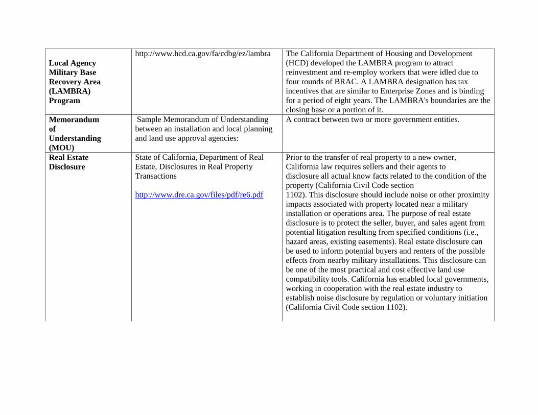
Local Agency
Military Base
Recovery Area
(LAMBRA)
Program
http://www.hcd.ca.gov/fa/cdbg/ez/lambra The California Department of Housing and Development
(HCD) developed the LAMBRA program to attract
reinvestment and re-employ workers that were idled due to
four rounds of BRAC. A LAMBRA designation has tax
incentives that are similar to Enterprise Zones and is binding
for a period of eight years. The LAMBRA's boundaries are the
closing base or a portion of it.
Memorandum
of
Understanding
(MOU)
Sample Memorandum of Understanding
between an installation and local planning
and land use approval agencies:
A contract between two or more government entities.
Real Estate
Disclosure
State of California, Department of Real
Estate, Disclosures in Real Property
Transactions
http://www.dre.ca.gov/files/pdf/re6.pdf
Prior to the transfer of real property to a new owner,
California law requires sellers and their agents to
disclosure all actual know facts related to the condition of the
property (California Civil Code section
1102). This disclosure should include noise or other proximity
impacts associated with property located near a military
installation or operations area. The purpose of real estate
disclosure is to protect the seller, buyer, and sales agent from
potential litigation resulting from specified conditions (i.e.,
hazard areas, existing easements). Real estate disclosure can
be used to inform potential buyers and renters of the possible
effects from nearby military installations. This disclosure can
be one of the most practical and cost effective land use
compatibility tools. California has enabled local governments,
working in cooperation with the real estate industry to
establish noise disclosure by regulation or voluntary initiation
(California Civil Code section 1102).

Supplement to the General Plan Guidelines, 2013
Resource
Conservation
Districts
(RCDs)
http://www.conservation.ca.gov/dlrp/RCD
/Pages/Index.aspx
RCDs are "special districts" of the state of California, set up
under California law to be locally governed agencies with
their own locally appointed or elected, independent boards of
directors. California RCDs implement projects on public and
private lands and educate landowners and the public about
resource conservation. RCDs, authorized under Division 9 of
the Public Resources Code, work together to conduct:
Watershed planning and management Water conservation
Water quality protection and enhancement Agricultural land
conservation Soil and water management on non-agricultural
lands:
Wildlife habitat enhancement
Wetland conservation
Recreational land restoration
Irrigation management
Conservation education
Forest stewardship
Urban resource conservation
The Department of Conservation provides assistance to
California’s 102 RCDs in their mission to develop a land
stewardship ethic that promotes long-term sustainability of the
state’s rich and diverse natural resource heritage. This support
can take the form of financial assistance through grant
programs; administrative education through California
Conservation Partnership (CCP) training.

Sound
Attenuation
Caltrans Highway Traffic Noise
Abatement:
http://www.dot.ca.gov/hq/oppd/hdm/pdf
/chp1100.pdf
Guidelines for Sound Insulation of
Residences Exposed to Aircraft Operations:
http://www.navfac.navy.mil
Sound attenuation refers to special
construction practices designed to
lower the amount of noise that
penetrates the windows, doors, and
walls of a building.
Subdivision
Ordinance
Planning, Zoning and Development Laws
http://www.opr.ca.gov/index.php?a=planni
ng/publications.html#pubs-P
An ordinance used by local
governments that sets forth the
regulations that guide site
development standards, such as road
and grading requirements, and utility
provision. Subdivision Ordinances are
also known as land development
control ordinance or platting).
Zoning Planning, Zoning and Development Laws
http://www.opr.ca.gov/index.php?a=planni
ng/publications.html#pubs-P
Local codes regulating the use and
development of property. The zoning
ordinance divides the city or county
into land use districts or "zones,"
illustrated on zoning maps, and
specifies the allowable uses within
each such zone. It establishes
development standards, such as
minimum lot size, maximum structure
height, building setbacks, and yard
size.

Supplement to the General Plan Guidelines, 2013
Air
Installations
Compatible
Use
Zone (AICUZ)
Program
http://www.navfac.navy.mil
The AICUZ program is a DoD
planning program that was developed
in response to incompatible urban
development and land use conflicts
around military airfields. The AICUZ
program seeks to provide information
on compatibility, develop a
cooperative relationship between
communities and military
installations, and provide land use
compatibility guidelines that protect
public health and safety and maintain
military readiness. Note: Some
Services use the singular form, Air
Installation Compatible Use Zone).
Air Force
General
Plan
Air Force Instruction (AFI) 32-706,
Comprehensive Planning:
http://www.e-publishing.af.mil
General Plan Guide:
http://www.afcee.brooks.af.mil
Similar to a local jurisdiction, an Air
Force Base (AFB) maintains a long‐range general plan. An AFB General
Plan is the primary document that
provides the installation commander
and other military decision makers
with a condensed picture of whether
or not an installation has the physical
assets and delivery systems to support
its mission. The purpose of the AFB
General Plan is to provide an
assessment of the installation’s
infrastructure and attributes for the
purpose of gauging the installation’s
development and

growth potential. In addition to its
general plan, AFBs maintain a
number of plans that describe the
operational parameters for activities
on the installation and in the airspace
around the base.
Army
Compatible
Use Buffer
Program
(ACUB)
http://www.sustainability.army.mil/tools/programtools_acub.cfm
ACUBs establish buffer areas around
Army installations to limit effects of
encroachment and maximize land
inside the installation that can be used
to support the installation's mission.
ACUBs support the Army's
responsibility as a federal agency to
comply with all environmental
regulations, including endangered
species habitat protection. By
working in partnership with
conservation organizations, ACUBs
can coordinate habitat conservation
planning at the ecosystem level to
ensure that greater benefits are
realized towards species and habitat
recovery. ACUBs also support local
and regional planning and
sustainability efforts by emphasizing
partnerships with state and local
governments and private conservation
organizations to work toward
common objectives and leveraging
public and private funds towards
those common goals.

Supplement to the General Plan Guidelines, 2013
Bird/Wildlife
Air
Strike Hazard
(BASH)
Program
An Air Force term for wildlife-related
hazards to aircraft. The Air Force
maintains a program to reduce these
hazards at all of its installations.
Community
Plans
and Liaison
Officer
(CP&LO)
The CP&LO serves as the Base
Commanding Officer’s direct
representative with local
communities, public elected officials,
other government agencies and major
landowners surrounding the Base.
DoD
Encroachment
Partnering
Authority
Chief of Naval Operations Instruction,
Encroachment Management,
OPNAVINST 11010.40, under
SECNAVY and OPNAVY
http://www.navfac.navy.mil
DoD partnering authority to execute
agreements to limit encroachments
and other constraints on military
training, testing, and operations.
Department of
the
Army
Environmental
Management
Systems
(EMS)
http://www.sustainability.army.mil/tools/programtools_ems.cfm
An EMS is the part of an
organization's overall management
system that integrates environmental
concerns and issues in the
organization's management processes.
An EMS addresses organizational
structure, planning activities,
responsibilities, practices, procedures,
processes, and resources for
developing, implementing, achieving,
reviewing, and maintaining
environmental policy. An EMS

enables
an organization of any size or type to
control the impact of its activities,
products, or services on the natural
environment, allowing it to not only
achieve and maintain compliance
with current environmental
requirements, but to recognize and
proactively manage future issues that
might impact mission sustainability.
Encroachment
Action Plan
(EAP)
Chief of Naval Operation Instruction
OPNAVINST 11010.40
http://www.navfac.navy.mil
An EAP is one of the implementation
tools within the Encroachment
Management Program. Development
of an EAP results in the
identification, quantification,
mitigation, and prevention of the
potential encroachment challenges to
an installation or a range.
Encroachment
Management
Program
Chief of Naval Operation Instruction
OPNAVINST 11010.40
http://www.navfac.navy.mil
The Encroachment Management
Program ensures the operational
sustainment for all Navy installations,
test and training ranges, air and water
operating areas (OPAREAs), special
use airspace, and military training
routes (MTRs). OPNAVINST
11010.40 also provides the authority
and guidance towards the preparation
of Encroachment Action Plans (EAP).
Formerly Used
Defense Sites
(FUDS)
Program
https://ekopowered.usace.army.mil/ecop/what_we_do/fuds
DoD is responsible for environmental
restoration of properties that were
formerly owned by, leased to or
otherwise possessed by the United
States and under the jurisdiction of

Supplement to the General Plan Guidelines, 2013
the Secretary of Defense. Such
properties are known as FUDS. The
Army is the executive agent for the
program and the U.S. Army
Corps of Engineers manages and
directs the program's administration.
The scope and magnitude of the
FUDS program is significant, with
more than 9,900 properties identified
for potential inclusion in the program.
Information about the origin and
extent of contamination, land transfer
issues, past and present property
ownership, and program policies must
be evaluated before DoD considers a
property eligible for
Defense Environment Restoration
Account (DERA) funding under the
FUDS program.
Installation
Master Plan
Navy Activity Overview Plan
https://eko.usace.army.mil/fa/arpmp
This Technical Manual (TM)
provides guidance on preparing the
Master Plan Report. The Master Plan
Report provides a concise,
comprehensive definition of planning
proposals to solve current problems
and meet future needs, as well as a
record of the analytical process and
rationale by which these proposals
were developed.
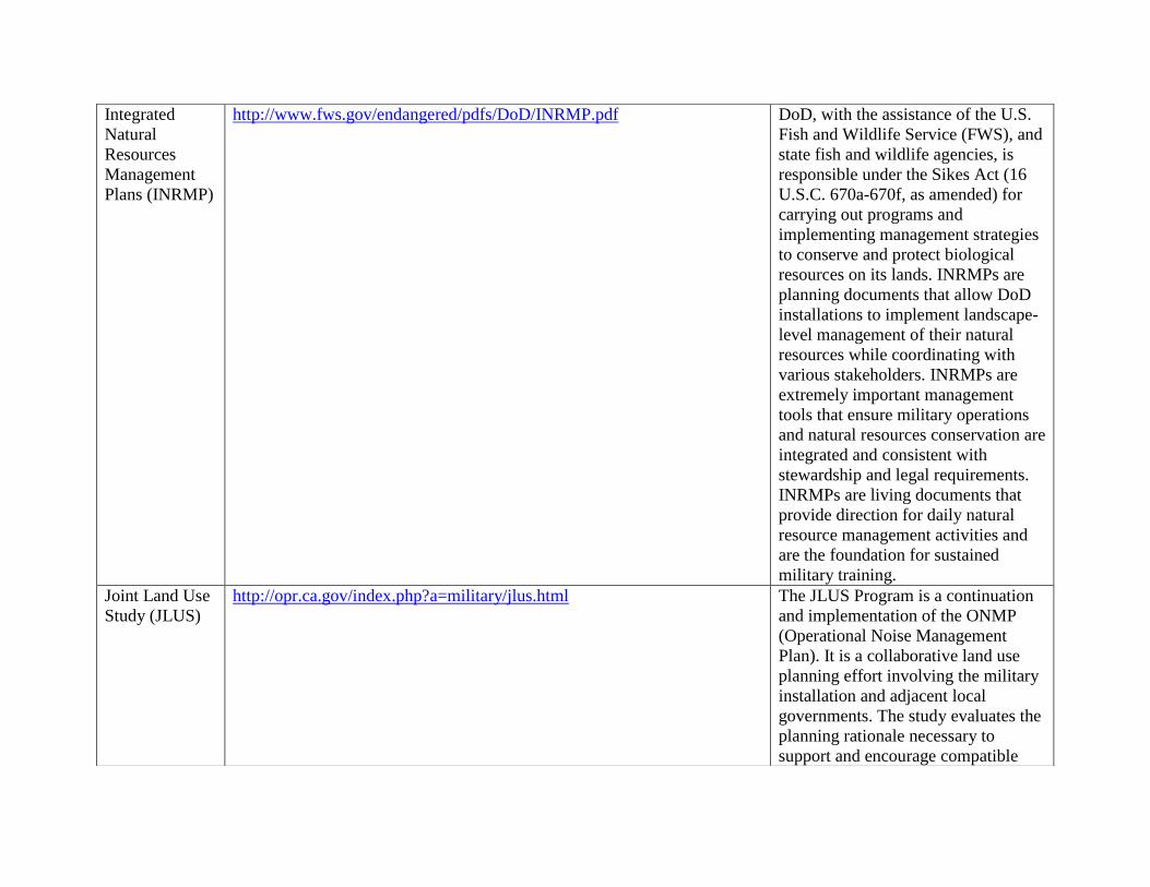
Integrated
Natural
Resources
Management
Plans (INRMP)
http://www.fws.gov/endangered/pdfs/DoD/INRMP.pdf
DoD, with the assistance of the U.S.
Fish and Wildlife Service (FWS), and
state fish and wildlife agencies, is
responsible under the Sikes Act (16
U.S.C. 670a-670f, as amended) for
carrying out programs and
implementing management strategies
to conserve and protect biological
resources on its lands. INRMPs are
planning documents that allow DoD
installations to implement landscape-
level management of their natural
resources while coordinating with
various stakeholders. INRMPs are
extremely important management
tools that ensure military operations
and natural resources conservation are
integrated and consistent with
stewardship and legal requirements.
INRMPs are living documents that
provide direction for daily natural
resource management activities and
are the foundation for sustained
military training.
Joint Land Use
Study (JLUS)
http://opr.ca.gov/index.php?a=military/jlus.html
The JLUS Program is a continuation
and implementation of the ONMP
(Operational Noise Management
Plan). It is a collaborative land use
planning effort involving the military
installation and adjacent local
governments. The study evaluates the
planning rationale necessary to
support and encourage compatible

Supplement to the General Plan Guidelines, 2013
land use development surrounding the
installation. Its purpose is to provide
support to sustain and provide
flexibility to military missions on the
installation, while guiding the long
term land use needs of the
neighboring counties and
communities.
Light and Glare
Controls
The best source for information on this topic is to consult with the local
jurisdiction or military service on applicable design requirements.
Controls which are designed to
reduce the amount of light that spills
into surrounding areas and impacts
regional ambient illumination.
Military
Influence
Area (MIA)
The City of Aurora, Colorado designates
Airport Influence Districts, near Buckley
AFB, which is an example of the use of
MIAs. http://www.auroragov.org
A MIA is an official geographic
planning or regulatory area where
military operations impact local
communities, and conversely, where
local activities may affect the
military’s ability to carry out its
mission. Note: These areas are also
referred to as a Region of Military
Influence (RMI), Military Influence
Planning District (MIPD), Military
Influence Overlay District (MIOD),
Military District Disclose District
(MIDD), Airfield Influence Planning
District (AIPD), and Areas of Critical
State Concern (ACSC)).

Memorandum
of
Understanding
(MOU)
Sample MOU between an installation
and local planning and land use approval
agencies.
http://www.hqafcee.brooks.af.mil/ec/noise/aicuz/ProgramGuide
A contract between two or more
government entities.
Office of
Economic
Adjustment
(OEA)
http://www.oea.gov/OEAWeb.nsf/Growth?readform
OEA can provide technical and
financial assistance for growth
management planning to state and
local governments who have been
significantly adversely impacted by
the rapid population growth from new
or expanding missions at existing
installations. For further information
please see Managing Community
Growth, Technical Bulletin 5.
Range Air
Installations
Compatible
Use
Zone
(RAICUZ)
http://www.navfac.navy.mil
(available under SECNAV and OPNAV
Directives links)
Navy/Marine Corps and Air Force
programs designed to protect public
health, safety, and welfare, and to
prevent encroachment from degrading
the operational capability of air-to-
ground ranges. This program is
similar to the AICUZ Program. It
includes range safety and noise
analyses, and provides land use
recommendations, which will be
compatible with range safety zones
and noise levels associated with the
military range operations.
Readiness and
Environmental
Protection
https://www.denix.osd.mil/portal/page/portal/denix/range/Compatible/REPI
DoD developed the REPI program as
part it’s overall Sustainable Ranges
Initiative (SRI), a multi-level effort

Supplement to the General Plan Guidelines, 2013
Initiative
(REPI)
designed to ensure the future use of
military training land by addressing
issues of potential encroachment on
military training. This effort
emphasizes the need for installations
to look beyond the fence to work
constructively and creatively with
communities and other stakeholders.
The projects aim to:
Foster partnerships with new allies
Preserve test and training space
Provide funding to assist military
installations in working with state and
local governments or
nongovernmental organizations
(NGOs) Acquire conservation
easements from willing sellers
Preserve high-value habitat
Limit incompatible development that
threatens to jeopardize military
readiness
Regional Shore
Information
Plan
(RSIP)
Chief of Naval Operations (CNO)
Instruction, Encroachment Management,
OPNAVINST 11010.45
http://www.navfac.navy.mil
(available under SECNAV and OPNAV
Directives links)
A comprehensive, long-range
regional plan encompassing a specific
geographic region. The RSIP
identifies alternatives for optimizing
the use of land and facilities, and
incorporates strategic CNO and
Installation Management Claimant
(IMC) visions through functional
consolidations, regionalization,
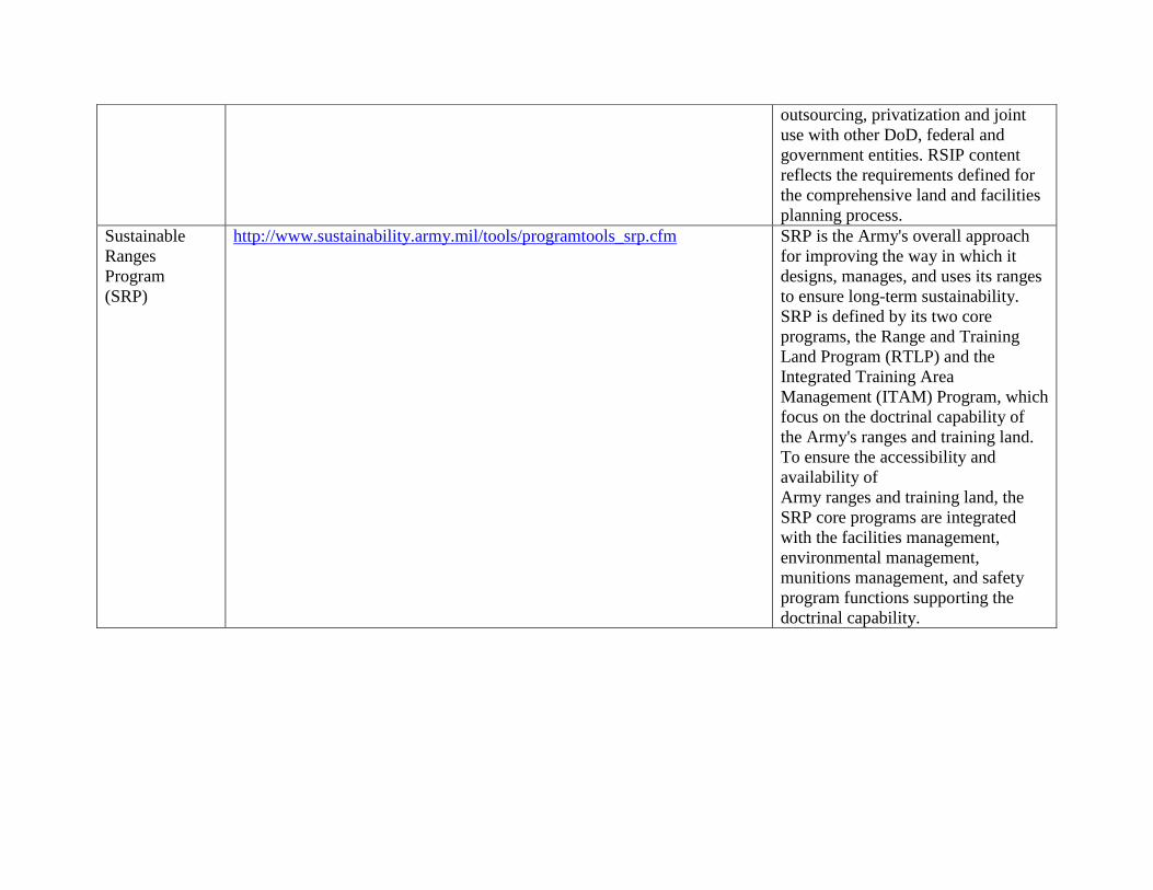
outsourcing, privatization and joint
use with other DoD, federal and
government entities. RSIP content
reflects the requirements defined for
the comprehensive land and facilities
planning process.
Sustainable
Ranges
Program
(SRP)
http://www.sustainability.army.mil/tools/programtools_srp.cfm
SRP is the Army's overall approach
for improving the way in which it
designs, manages, and uses its ranges
to ensure long-term sustainability.
SRP is defined by its two core
programs, the Range and Training
Land Program (RTLP) and the
Integrated Training Area
Management (ITAM) Program, which
focus on the doctrinal capability of
the Army's ranges and training land.
To ensure the accessibility and
availability of
Army ranges and training land, the
SRP core programs are integrated
with the facilities management,
environmental management,
munitions management, and safety
program functions supporting the
doctrinal capability.

Supplement to the General Plan Guidelines, 2013
The significant wind resources in Kern County make it an ideal location for renewable energy
facilities, such as wind turbines. However, since Kern County is home to numerous critical
military operating areas, the possibility for land use and airspace incompatibilities is high. Wind
turbines can create problems for nearby military radar flight tests because they are physical
obstructions and are a source of radar interference. In order to avoid potential land use conflicts
and operations interference associated with the designation of wind corridors, the Department of
Defense, the Bureau of Land Management, California State Representatives, including the Public
Utility Commission, California Department of Forestry and Fire Protection, California
Department of Parks and Recreation, and the California Energy Commission teamed up and
established the Regional Wind Work Group (RWWG), Region IX. The purpose of the RWWG
was to address Kern County and Region IX challenges and develop a strategy for designating
areas appropriate for wind energy uses.
The goals of the project were to:
o Protect military Critical Operating Areas
o Provide key communication tool to developers and land use decision makers
o Simplify Issues
o Maximizes limited resources saving money

o Provides Model for Other Counties and/or regions
The final product is an easy to read user friendly map that reflects areas where certain types of
activities are appropriate and where they are not appropriate.
The Kern County RYG established a model for other regions and as a result the State of
California has produced a statewide RYG Map.

Supplement to the General Plan Guidelines, 2013
Part E. Bibliography
Brasher, DeEllen. Wind Energy and the Military Mission (PowerPoint presentation). Department
of Defense, Regional Environmental Coordinator Officer, Navy Region Southwest. Desert
Managers Group, January 17, 2006.
California Governor’s Office of Planning and Research. California Advisory Handbook for
Community and Military Compatibility Planning, October 2016.
California Governor’s Office of Planning and Research. 2003 General Plan Guideline, October
2003. http://www.opr.ca.gov/planning/publications/General_Plan_Guidelines_2003.pdf
Lachman, Beth E., Anny Wong and Susan A. Resetar. Thin Green Line: An Assessment of
DoD's Readiness and Environmental Protection Initiative to Buffer Installation Encroachment.
RAND National Defense Research Institute, 2007.
http://www.rand.org/pubs/monographs/2007/RAND_MG612.sum.pdf
National Association of Counties – The Voice of America’s Counties, Encouraging Compatible
Land Use between Local Governments and Military Installations, April 2007.
Office of Economic Adjustment. Practical Guide to Compatible Civilian Development near
Military Installations, July 2005.
http://www.oea.gov/OEAWeb.nsf/A148AD244D3465E78525710F0053E04C/$File/Preface.pdf
Otte, Aaron. Desert Tortoises Get Help From the Marines. Endangered Species Update, Jul-Sep
2006. http://www.fws.gov/ENDANGERED/bulletin/2006/ES_Bulletin_07-2006.pdf

Military Mailing Addresses for SB 1462 Notification
All SB 1462 required referrals to the United State Military must be addressed to the following single points of contact for the
four Military branches listed below. All SB 1462 required documents must be sent by US Mail. Please also send SB 1462
notification via email.
US Air Force Steve Arenson
Regional Environmental Officer for California
Western Region Environmental Office
US Air Force
50 Fremont Street, Suite 2450
San Francisco, CA 94105-22230
Gary Munsterman
AFCEC/CPPR
US Air Force
50 Fremont Street, Suite 2450
San Francisco CA 94105-22230
(415) 977-8884
US Army
Region Nine Tim Kilgannon
Region Nine Environmental Coordinator
Regional Environmental and Energy Office
Office of the Deputy Assistant Undersecretary of the Army
Office of Strategic Integration
721 19th St., Room 427
Denver, CO 80202
Fort Irwin Phil A. Crosbie
Chief, Force Integration (FI) NTC G3
P.O. Box 10172
FT Irwin, CA 92310
Fort Hunter Ligget Gary Houston
Chief
Environmental Division
Directorate of Public Works
USAG Fort Hunter Ligget, CA 93928
US Navy Steve Chung
Community Plans and Liaison Officer
Navy Region Southwest
US Navy
1220 Pacific Highway
San Diego, CA 92132-5190
US Marine Corps Patrick Christman
Director
Western Region Environmental Office
US Marine Corps
Building 1164, Box 555246
Camp Pendleton, CA 92055-5246
Recommended


![Asia Pacific Sr. Leader Civil Military Seminar at Hawaii Aug 30 - Sept 1, 2010 [Compatibility Mode]](https://img.pdfslide.us/doc/110x75/577ce4b31a28abf1038ef598/asia-pacific-sr-leader-civil-military-seminar-at-hawaii-aug-30-sept-1-2010.jpg)