CLIMBS AND EXPEDITIONS 141
later by John Otter. On August 29, Hildebolt, Radford, and I climbed the second highest peak in the area, Cocked Hat (7410 feet), in continuous snow and poor visibility. We are unaware of any previous ascent. One technical rock route was done on the north ridge of P 6290, east of St. Patrick’s Creek (Gordon and Emily Benner, Hildebolt, Radford). Other peaks climbed were Chimney Mountain and Rock, Whiteface, Midnight Mountain, Wien Mountain, Amauk and Apoon. Other trip members were Chris Christensen, Fred Derose, Wim DeWit, Charles Funk, Bill Knowland, and Paul Studemeister.
GORLWN BENNER
Chilkat Range. Chuck Warren, Dave Butherus, Ted and Steve Lewis, Duncan Crosby and I as leader visited the heart of the Chilkat Range in southeastern Alaska at the head of the Davidson Glacier in June. We climbed P 6658, the main peak south of the Davidson-Casement Glacier divide on June 11. This is on the boundary of Glacier Bay National Monument. The all-snow route was easy, but the views of the many rugged peaks of the region were spectacular. We climbed P 5900 on June 15 from Base Camp at 3800 feet on the Davidson Glacier. We climbed the peak from the north side after crossing a pass to its east. It is on the north side of the main branch of the Davidson, 1 Yz miles east of the Glacier Bay National Monument boundary. Numerous ice worms, Mesemhytraeus solifugus, were found on the glacier surface on many nights. We created a sensation in Haines when we returned with live worms. The hotel proprietor took them out of his refrigerator and passed them around to his dinner guests to prove it was not another Robert Service type of hoax!
LAWRENCE E. NIELSEN
South Taku Tower, East Face. Daniel Reid and others made the first ascent of the difficult east face of South Taku Tower during the summer, placing no bolts and finding an F8, A4 standard. For the Juneau Icefield, the weather was quite good and allowed them to make the long trek across the icefield and an ascent of the Devil’s Paw. We hope to have a fuller account in the A.A.J., 1975.
Washington-Cascade Mountains
Mount Rainier, Willis Wall. In early May, Dusan Jagersky and I climbed about half way up the central rib on Mount Rainier’s Willis Wall when a large avalanche came within 100 yards of us and swept the entire right side of the wall. This, combined with an unexpected warming trend, prompted us to make an ascending traverse to the eastern side of the wall, away from the giant ice cliff. We finished this variation by doing
142 THE AMERICAN ALPINE JOURNAL
the last pitch or two of Curtis Ridge. Rockfall and heavy, unconsolidated snow hampered us. Grade IV or V.
GREGORY C. MARKOV, Unafiliated
Mount Rainier, Direct Russell Cliff. On July 7 to 8 the first direct ascent of Russell Cliff was accomplished by Jim Springer, Dean Bentley, and me, all seasonal NPS rangers; with the support of Gordon Ball of Seattle. The route follows the 1960 Russell Cliff-Upper Curtis Ridge route, traversing across the broken Winthrop Glacier, then ascending to the base of the large, steep snow face (known alternately as the “Russell Bowl” or “Ball’s Wall”). From here, the route proceeds directly up the snow face to the three prominent rock bands which offer the only major diffi- culty. We ascended the points of weakness in each of the rock bands, using a picket and two flukes for protection. The rock on Russell Cliff, like all Mount Rainier rock, cannot be trusted; in addition, the snow between the bands was found to be very rotten, frkquently giving way under foot pressure to reveal a thin coating of brittle water ice beneath. The snow ledges we traversed on the upper part of the route were about five to fifteen feet in width, and measured about 55”, with one short pitch of 65”. We named the route “Dalle-Molle’s Wet Daiber” after both John Dalle-Molle and Ome Daiber. 8 hours from Camp Schurman to summit. Grade II.
JOHN L. THOMPSON, Unaffiliated
Big Four, North Face. January 3, 1974, Rich Carlstad and Cal Fol- som climbed the gully to the east of the standard north rib route. Descent was made by Route Two to the saddle between Hall Peak and Big Four. 13 hours round trip.
Ten Peak Mountain, North Buttress. This is the rather prominent buttress which can be seen on the Sierra Club poster, “The Wild Cas- cades.” In mid-August, Phil Leatherman and I made the approach via the White River trail and a cross-country high route through a lovely, untrammeled basin. The climbing on this 1800-foot granitic buttress ranged from third class to fifth class (up to F7 or F8). Grade II or III.
GREGORY C. MARKOV, Unaffiliated
P 4245, “Exfoliation Dome” north of Helena Peak. On September 15, the north ridge of this uncharacteristic granite formation a few miles south of Darrington was climbed by Greg Ball and me. Approach was from the west left of a slabby stream gully to a large tree on the ridge crest just below where the ridge steepens. A long free pitch on slabs and cracks on the ridge crest leads to a ledge beneath a twenty-foot wall. Two shorter pitches, on both of which we used some aid, led to the end
CLIMBS AND EXPEDITlONS 143
of the roped climbing. Several hundred feet of scrambling including a knife-edge traverse took us to the top. Time: five hours from the car. F7, Al. A selection of small nuts plus a blade or two are sufficient. This ’ route probably involves less roped climbing than any other on the dome.
BILL FRYBERGER, Unaffiliated
Forbidden Peak, Northwest Face. This very aesthetic alpine route combines a good short ice climb on the west face of the north ridge with the very enjoyable rock climbing of the upper north-ridge route. The ice face is composed of two sections divided by a narrow constriction, the upper section ending at the cornice in the middle of the north ridge. After an initial difficult bergschrund the route consisted of approximately 900 feet of front pointing on hard, brittle ice covered by a thin layer of fresh snow reaching an angle of 50” on the upper section. This face had been entirely exposed ice the fear before so it seems that this route should provide a good ice climb most years late in the season. Three hours were sufficient for a solo ascent from the Forbidden Glacier to the summit. Climb completed, August 23.
JOHN TEASDALE, Unaffiliated
Copper Mountain. The highest (7840 feet) and most southerly peak of the Liberty Bell-Early Winters Spires ridge system, this pleasant but obscure peak may be approached via a cross-country scramble from the North Cross State Highway. From Kangaroo Pass George Mustoe and I traversed across talus and snow to reach the south ridge. After several hundred feet of unstable rock, the ridge becomes a narrow granite a&e which is ascended to the south summit. From here the higher north peak is an easy stroll. Class 3-4. 5 hours up. The only previous ascent appeared to be via helicbpter in 1962 by a U.S.G.S. party. Peak 7565 (“Pica Peak”), the pyramid prominently visible to the south from the meadows at the head of Early Winters Creek, proved to be an easy ascent by the southeast ridge, with the short final pitch offering the only real climbing.
KREIG MCBRIDE, Unafiliated
Cutthroat Peak. In August, Hugh Sincock and I climbed a new route on the southwest side of Cutthroat Peak. This is a clean, winding gully that joins the west ridge just below the summit. It is the second gully right (south) of the ridge. The climbing is easy class 5 on slabs that are generally solid, sometimes flaky, and always shy on cracks. Two much more difficult-looking steps were bypassed on the left. From the ridge crest we joined the original route by climbing to the ledge behind the prominent gendarme via a short wall to its right.
DOUG JONES, Unufiliated

I44 THE AMERICAN ALPINE JOURNAL
Nooksack Cirque Icewall. Once described as the “deepest, darkest, coldest hole” in the North Cascades, the Nooksack Cirque offers many short ice climbs of a high standard. In early September, Dusan Jagersky and I climbed the biggest ice face in the cirque: a 1200-foot jewel ris- ing in a concave arc of steepness from 45” to 55”. We had difficult ice climbing in the East Nooksack Glacier just to reach the face’s base, about midway along Jagged Ridge from Cloudcap Peak. To gain the face proper, we climbed a lOO-foot ice hose, vertical for several feet in its hardest section. We picked an obvious ice rib up the face, one of several rising in parallel lines. Remarkably, the ribs were occasionally bisected by small crevasses which made excellent belay platforms. I was hit on the arm by a falling rock in mid-face, but the ascent was otherwise straightforward front-pointing on good ice. At the top of the wall, the last pitch exceeded 55”; we finished in a narrow, twisting, Eiger-like gully. To get off, we traversed over Shuksan in circuitous fashion to Lake Ann.
JAMES WICKWIRE
Castle Peak, North Face. Castle Peak is located in the Pasayten Wilderness just northeast of Mount Hozomeen. The peak is a scramble on three sides, but its broad north face has route possibilities of 1000 feet on solid, blankish granite. In September Fred Beckey, Phil Leather- man, and I chose a route up a broad blocky buttress on the far right side of the face. Climbing was mainly fourth class with a few fifth-class sections. Grade II.
GREGORY C. MARKOV, Unaffiliated
Cathedral Peak, Southwest Ridge. During August a large Common- wealth team consisting of Howie Richardson, Robin Mounsey,’ Bob Cuthbert, Bruce McPherson and myself made the first ascent of the south- west ridge integrale of this granitic peak. Steep, enjoyable crack climb- ing intersected by large terraces characterized the climbing. 9 hours, 12 roped pitches, NCCS IV, F8, A2.
DAVID NICOL, Alpine Climbing Group
California-Sierra Nevada
Sawtooth Peak, North Face. Because the nearly vertical profile of Sawtooth’s north face is very noticeable from the road approaching the Kaweah, then again nearing Mineral King, it seemed quixotic that climb- ers had not probed its defenses. On September 30, Greg Thomsen and I left our high camp at Columbine Lake, plodded up loose scree in the shadow of a cool morning, then spent until the early afternoon climbing a rather direct route on the precipitous face. Most of the route weaved up a series of steep blocks and cracks, with an occasional brief ledge to
CLIMBS AND EXPEDITIONS 145
regain balance. A few aid pitons were placed. The only unpleasant feature were blocks that appeared possible to displace with careless leverage; needless to say, we displayed much tenderness at these mo- ments, with the result that the blocks are still there. The climb is to be recommended. NCCS III, F7 or F8, Al.
FRED BECKEY
The Juggernaut. After Jack Roberts, Dave Black, and I climbed a simply gorgeous face, really a prow, southwest of Crown Lake, we could not focus on a name other than an uninspired “Crown Lake Buttress”. Greg Donaldson, who had earlier climbed most of two pitches up the prow, suggested “The Juggernaut” for the formation, which tops out on the boundary of Yosemite National Park. Its beauty would be legendary in the Valley, but in the high country east of Sawtooth Ridge, it is mainly a backdrop for the fisherman. The route ascends the obvious crack system near the center of the prow, closely right of two gigantic overhanging arches. The climb worked out to five long, hard pitches, with classic moves at regular intervals. A few tricky pins of aid on the second pitch got us by a debatable jam-crack struggle. The rock is superb-it seemed there was not a loose stone anywhere. We began the climb September 14, left two ropes, then completed the route the next day in time for the hike out to Twin Lakes. NCCS IV, F9, A2.
FRED BECKEY
Horse Creek Tower. This surprising monolith is on the lower scarp of Sawtooth Ridge, in full view of Twin Lakes, but it had not been climbed. The route on the south face included some challenging climbing, both free and aid. Leland Davis, Mike McGoey and I made the ascent on May 16. NCCS II, F8, A3.
FRED BECKEY
Mount Thor, Southeast Face. A new route, using the prominent dihedral bearing toward the east summit crest, was done on May 19 by Leland Davis, Mike McGoey, and me. The key pitches were the second one in the dihedral, and the final one on the headwall beneath the crest, these both going free. The only aid was a slab providing entry to the headwall cracks, and here 7 bat-hooks were used (no bolts placed). The route is of easy approach from the Mount Whitney trail and highly recommended. NCSS III, F8, A2.
FRED BECKEY
Stonehouse Buttress, Southeast Face. The Milky Way Chimney, a new route on Stonehouse Buttress, was done on April 29 and 30 by Jack
146 THE AMERICAN ALPINE JOURNAL
Roberts, Hooman Aprin, and me. The nine-pitch route duplicates a pre- viously established route on the southeast face for 2% pitches, then bears left and directly up the corner of the buttress. A classic, curving chim- ney, nearly two pitches in length, is the hardest and most unprotected situation on the route. The summit of the buttress was reached just before dark; night and rainfall made the descent through bush and rocks quite unpleasant. NCCS IV, F9, A3.
FRED BECKEY
Charlotte Dome, Southwest A&e. Dave Lomba and I climbed 11 pitches of choice high-country granite along this narrow ridge. We skied over Kearsarge Pass in early May and camped near Bullfrog Lake. The climb was all free, clean, and took most of a day. We began climbing in the early afternoon, but didn’t return to camp until one A.M. NCCS IV, F9.
GALEN ROWELL
Crystal Crag, East Face. Vern Clevenger and I climbed a three-pitch F9 route on the left side of this face in January. It begins on the right side of a prominent dihedral. Crystal Crag is near Mammoth Lakes. NCCS I, F9.
GALEN ROWELL
Towers Below Wheeler Crest. In September Chris Vandiver and I climbed two virgin towers in this region, naming them Soaring Eagle Tower and Chicken of the Sea Tower. The former was a 500-foot F8 free climb on the east face, and the latter was a F5 climb via the north ridge. NCCS III, F8 and F5.
GALEN ROWELL
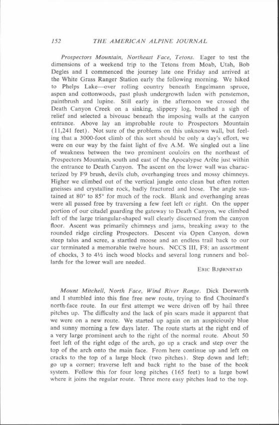
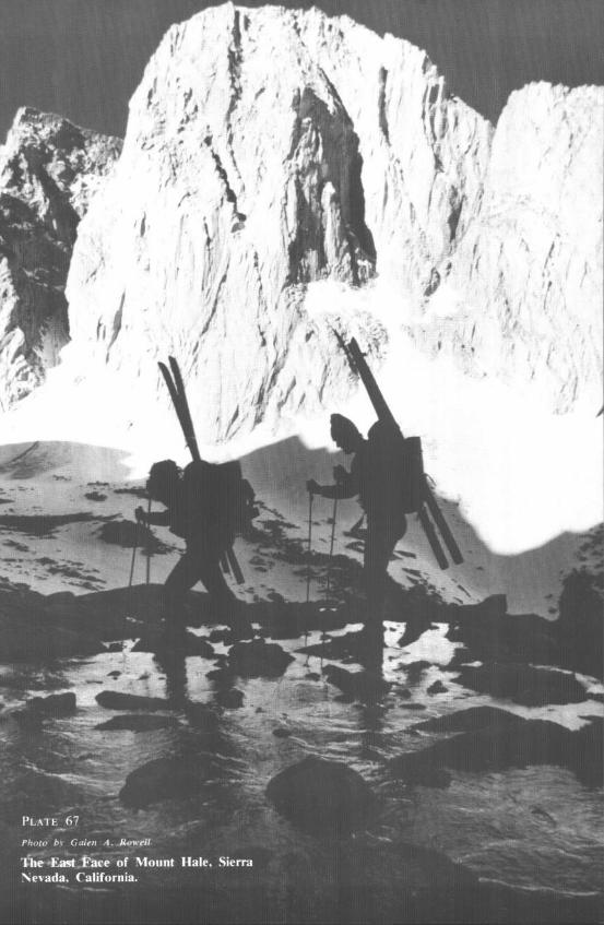
Mount Hale Pinnacles and Mount Hale, East Face. On the ridge of Mount Hale that extends toward Mount Whitney, before ending above Arctic Lake, there are two very prominent towers separated by a gap of 100 feet. I climbed them in June with a belay from Jeff Campbell. The southerly tower is F6 and the northerly, F8. They are classic needles of monolithic rock that appear vertical from all sides. The east face of Mount Hall, a 1500-foot wall, is a Sierra classic, My first at- tempt in June with Greg Henzie and Jeff Campbell failed because of difficulty and acclimatization (Hale is 13,440 feet). In July I returned with Dennis Hennek and Dave Lomba. Dave was hit by the altitude on the approach, which crosses a 13,000-foot pass, and he didn’t make the final climb. Dennis and I left very early and soon found ourselves on continuously difficult rock. Five pitches in a row were F8 or harder. A few pitons were used for direct aid on an overhanging off-width crack,
CLIMBS AND EXPEDITIONS 147
but otherwise the climb was free and clean. We tried to climb quickly as possible and reached the summit at 6:30 P.M. The climb is com- parable in length and difficulty with the north wall of Sentinel Rock in Yosemite and is rated NCCS V, F9, A3.
GALEN ROWELL
Lone Pine Peak, South-Southeast Face. From the Stone House the south-southeast face of Lone Pine Peak presents the following features: a large couloir starts to the right of the lowest point of the face and ends very high beneath a steep step through which the route finishes; to the right of the large couloir a huge ledge can be seen in the middle of the face; last, still on the right, the wall is limited by an ill-defined ridge with many pillars. On July 12 and 13, Tom Birtley and I climbed a new route. It starts below the left side of the huge ledge, to the left of an overhanging cascade. Ascend some short walls, tending to the left, to reach a gully and the huge ledge (F2). Follow the ridge above the left comer of the ledge (Fl ) and descend easily from a small co1 to reach the large couloir ending in F4. After 300 easy feet in the couloir the route goes on the right on excellent rock, following a deep cleft in the main face for most of the 14 pitches to the summit plateau. The first overhang is climbed by its left chimney (F7), the second and third with aid to the left (Al, 3 pitons and Al, 10 pitons). The last is avoided by a traverse to the right (F6) which leads to a very hard chimney (F9, 1 piton). From the couloir to the plateau, the climbing is fairly sustained. The roundtrip from the Stone House takes about 18-20 hours. In all, 25 pitons and 2.5 nuts. NCCS IV, F9, Al.
HENRI AGRESTI, Club Alpin FranGois
No Name Pyramid. On August 12, Jack Roberts, Mike Graber, and I climbed a new route on the east face of a prominent peak referred to as “nameless pyramid 0.2 miles south of Kearsarge Pass” in the guide- book. Starting from Heart Lake, our route follows a diagonal crack system clearly visible in the center of the east face. A few pitches of very interesting face and crack climbing and a very long traverse left and then back right ended at the right skyline of the pyramid. The exhilarating pitch on the sharp summit artte (climbed in 1952) took us to the top of this 12,000+ peak. NCCS III, F8.
HOOMAN APRIN, Unaffiliated
Mount Stewart, North Face. A long approach on the High Sierra Trail and up Lone Pine Creek ended at the base of the previously unclimbed north face of Mount Stewart. On the following day, August 19, Mike Graber, Jack Roberts and I started out on the giant, usually snow-covered platform at the base of the two parallel buttresses directly below the
148 THE AMERICAN ALPINE JOURNAL
summit. Some 1500 feet of alpine climbing on good high-altitude granite ended a few feet east of the summit. The route lies mostly left of the east buttress. NCCS III, F6.
HERMAN APRIN, Unafiliated
Banner Peak, East Face-Fur Right Side. On the 28th of August, Kevin Sutter and I climbed what we believed to be a new route on the right side of the east face of Banner Peak. Two pitches of fourth class led to the top of the shoulder just north of the glacier under the face. From the shoulder, two pitches (F6) up a prominent chute led to easy scrambling for 200 feet. The scrambling led to a talus-filled notch from which three very enjoyable pitches put us on the summit ridge near its north end. NCCS III, F6.
DAVID HARDEN, Una#iliated
Peak 11,998, The Cooked Walnut. The LeConte Divide in general holds little of interest for the technical climber. Rising above Arctic Lake, however, is a beautiful north face that has escaped even the notice of Fred Beckey. On August 31, Rick Boyce, Curt Chadwick, and I climbed a crack system immediately right of a prow-like pillar which splits the center of the face. Our route offers 600 to 700 feet of mostly free climbing on excellent rock. Take several bongs up to 3 inches. Other possibilities exist, but they are all well guarded by the 17-mile approach. NCCS II, F7, A2.
WALT VENNUM
California-Yosemite
Half Dome, Northwest Face. In August, Doug Robinson, Dennis Hen- nek, and I climbed the normal route entirely on nuts and runners. We avoided fixed pitons in all places except for a tension traverse on the first zig-zag where a nut placement would have necessitated the hammering out of a ring angle fixed by the 1957 first-ascent party. We were able to free-climb over 80% of the route without climbing anything harder than F9.
GALEN ROWELL
El Capitan, End All Route. Aside from routes mentioned elsewhere in this Journal, other fine routes were made in the Yosemite. These in- cluded a new route on El Capitan to the right of the Wall of Early Morning Light made in nine days with much difficult nailing but only 85 bolts, many at belay points. The climbers were Charlie Porter, Chris Nelson and the Canadians Hugh Burton and Steve Sutton. Great emphasis was also placed on shorter, very difficult climbs elsewhere in the Valley.
CLIMBS AND EXPEDITIONS 149
Nevada
Mount Charleston. As seen from the desert to the east, the northern upper crest of Mount Charleston in appearance justifies its local name, “Mummy Peak.” In October Scott Hamell and I climbed the northwest buttress, so prominent from the Lee Canyon ski area. Rock is dolomite, sometimes sound, sometimes not. The climb could readily be made in one day, but our schedule was such that a bivouac was in the program. NCCS III, F8, Al.
FRED BECKEY
Arizona
Jacobs Ladder, Monument Valley. On May 5 Fred Beckey, Bob Degles and I made the first ascent of this 300-foot tower, which is iden- tical in appearance to Standing Rock in Monument Basin Canyonlands, Utah. NCCS III, F6, A3; 53 pitons, 4 chocks, 7 bolts.
ERIC B J$RNSTAD
Dragoon Mountains, Cochise Stronghold. There are many waves and spines of granodiorite in outline along the ridges and flanks of the Dra- goon Mountains. The northern side had apparently never been visited by rock climbers. In February Phil Warrender, Greg Bender and I made first climbs of three spectacular towers: The Symbol, The Fist, and Birthday Tower. They are most obvious and located at low-level on the escarpment, west of the ranch at road’s end. Rock is excellent; the climbs range from F4 to F7. Later in winter John Rupley and I were literally blown off Vortex Tower (north side of Rocketellow Dome) by high winds, but returned to complete the five-pitch climb, a very satisfying route on friction slabs and jam-cracks.
FRED BECKEY
Grand Teton, First Winter Ascent and Descent of East Ridge. The technical challenge of the east ridge no longer appealed after the north and west faces. However, Jock Glidden, Dave Lowe and I had a score to settle as the east ridge had turned us back several times because of bad weather. Teton winter mountaineering is basically dependent on weather. If good, anything can be climbed; if bad, it may be difficult even to get to the base. Rather than to carry very heavy loads to the bottom of a climb and wait for a clear day, we prefer to try weekend climbing from Salt Lake City and to carry light loads, alpine style. We left Beaver Creek at 5.30 A.M. on Saturday of the Washington’s Birthday weekend. It was difficult to stay in balance while crossing the snowmobile ruts in the dark. We reached Burnt Wagon Gulch at daylight and the unco-
150 THE AMERICAN ALPINE JOURNAL
ordinated feeling went away. By lo:30 we were at Delta Lake. At the base of the ridge we removed skis and immediately plunged into the snow up to our knees. We knew we’d never reach the far side of the Molar Tooth on the first day. The lower section of the ridge was tech- nically easy. With judicious route-finding, the only difficulty was break- ing trail. The wind crust was just hard enough to bang shins without supporting weight. When we reached the base of the Molar Tooth at 9:30 P.M., we were ready to make camp. We had only down jackets, a stove and snow shovel for a bivouac. At first light we began climbing the pitch leading to the notch on the south side of the Molar Tooth. Lack of wind and clouds made difficult moves possible barehanded. We wasted a half hour trying to go directly up the ridge from the notch and then rappelled into the couloir. After delightful solo 12-pointing on firm snow and a few moves around the chockstone, we arrived at the notch at 10:30. Dave led for several pitches on the snow-covered slabs above the notch-until he ran out of pins while we moved simultaneously behind him. Jock then led up to the traverse around the Second Tower, which was my lead. It presented the most interesting moves of the climb-slabs covered with steep unstable snow, a cornice which had to be chopped through and finally a chimney chocked with ice, which is fourth-class in summer. After going around the chimney, we plowed on up the snow- field. Fortunately the snow seemed stable even though again we broke through to our knees. After interminable labor, we arrived at the sum- mit block and a short pitch put us on the summit at five P.M. A short descent to the south brought us to snow deep enough for a cave. Without sleeping bags there was little sleep as we shifted from position to position, waiting for morning. In the morning wind and snow produced more worry about avalanches on the summit snowfield. However we were only able to create sloughs from the 2 inches of new snow. Except for three rappels, we down-climbed everything, following the remains of our tracks. It was twilight when we reached Beaver Creek.
GEORGE H. LOWE
Grand Teton, Southeast Chimney. By taking advantage of an impor- tant variation pioneered in 1960 by Lev, Greig, Glosser, and Laing, a new route on the Grand Teton was found by David Lowe and me on August 5. The 1960 variation started from Glencoe Co1 up toward the face of the firs! tower of the Underhill Ridge, and then cut right up a series of chimneys to the east of the ridge, instead of left as in the standard (1931) Underhill Ridge route. After about five leads the 1960 party cut back left (south) from under a prominent grey overhang to regain the crest of the ridge just below the final tower. From beneath this same overhang the 1973 party cut horizontally right for 150 feet to the beginning of the southeast chimney which lies at the north edge of the
CLIMBS AND EXPEDITIONS 151
east face of the Underhill Ridge. The narrow chimney is a significant feature of this side of the mountain, extending for over 300 feet to the vicinity of the notch which separates the last tower on the ridge from the main slabs of the southeast face of the Grand. The first 50 feet up the chimney were strenuous but reasonable to a stance just below the crux, a narrowing of the chimney with two smooth, protruding flakes. Passage of this section was very difficult indeed, since a light snow and rain had wet the rock and there were no holds on the outside smooth and vertical faces of the chimney. The conclusion of this crux pitch was a belay point in the same chimney which now formed the right (north) edge of a slabby friction face. The climb probably should have con- tinued up the chimney, but instead an exploratory traverse was made out onto the slabs, and then back to the right until only 25 feet from the chimney. The next lead regained the chimney and turned up easily for 60 feet until F7 difficulties were encountered, requiring some stemming to reach a belay in a rather inadequate alcove, just below the last steep section of the chimney. The final exciting exit from the top of the chim- ney involved some very small holds and a beautiful lieback in the crack to which the chimney had dwindled. A short scramble up the east face of the ridge then led to the notch where the usual southeast slabs were followed to the summit. While the technical difficulty of the southeast chimney is comparable to some of the north and west routes on the mountain, the relative ease of escape and the ability to see the approach- ing weather make this climb a less serious undertaking. The rock is excellent, but the awkwardness and strenuousness of the crux may keep this route from great popularity. III, F8.
LEIGH N. ORTENBURGER
South Tetan, East Snow Couloir. On August 1, Jim Olson and Tom Watson made the first ascent of this couloir which has been in direct view of two generations of climbers. From the highway somewhat south of east, the prominent snow couloir can be seen to cut directly up the east slopes of the South Teton, ending on the southeast ridge about 300 feet below the summit. From a camp at Snowdrift Lake, Olson and Watson ap- proached the couloir via the large gully separating the South Teton from Matternaught Peak to the large snowfield which abuts the south faces of Gilkey Tower and the Icecream Cone. Turning left (west) from this snowfield, they entered the couloir itself where a total of nine leads of moderate snow climbing were found. About two-thirds of the way up the couloir, a short rock wall capped by a chockstone presented the only rock problem of the route. It was passed on the left to reach the final three, increasingly steep, snow leads to the usually corniced top of the couloir. Some rockfall was encountered in the lower sections of the couloir. II, F5.
152 THE AMERICAN ALPINE JOURNAL
Prospectors Mountain, Northeast Face, Tetons. Eager to test the dimensions of a weekend trip to the Tetons from Moab, Utah, Bob Degles and I commenced the journey late one Friday and arrived at the White Grass Ranger Station early the following morning. We hiked to Phelps Lake-over rolling country beneath Engelmann spruce, aspen and cottonwoods, past plush undergrowth laden with penstemon, paintbrush and lupine. Still early in the afternoon we crossed the Death Canyon Creek on a sinking, slippery log, breathed a sigh of relief and selected a bivouac beneath the imposing walls at the canyon entrance. Above lay an improbable route to Prospectors Mountain (11,241 feet). Not sure of the problems on this unknown wall, but feel- ing that a 3000-foot climb of this sort should be only a day’s effort, we were on our way by the faint light of five A.M. We singled out a line of weakness between the two prominent couloirs on the northeast of Prospectors Mountain, south and east of the Apocalypse Arete just within the entrance to Death Canyon. The ascent on the lower wall was charac- terized by F9 brush, devils club, overhanging trees and mossy chimneys. Higher we climbed out of the vertical jungle onto clean but often rotten gneisses and crystalline rock, badly fractured and loose. The angle sus- tained at 80” to 85” for much of the rock. Blank and overhanging areas were all passed free by traversing a few feet left or right. On the upper portion of our citadel guarding the gateway to Death Canyon, we climbed left of the large triangular-shaped wall clearly discerned from the canyon floor. Ascent was primarily chimneys and jams, breaking away to the rounded ridge circling Prospectors. Descent via Open Canyon, down steep talus and scree, a startled moose and an endless trail back to our car terminated a memorable twelve hours. NCCS III, F8; an assortment of chocks, 3 to 4% inch wood blocks and several long runners and bol- lards for the lower wall are needed.
ERIC BJQIRNSTAD
Mount Mitchell, North Face, Wind River Range. Dick Dorworth and I stumbled into this fine free new route, trying to find Chouinard’s north-face route. In our first attempt we were driven off by hail three pitches up. The difliculty and the lack of pin scars made it apparent that we were on a new route. We started up again on an auspiciously blue and sunny morning a few days later. The route starts at the right end of a very large prominent arch to the right of the normal route. About 50 feet left of the right edge of the arch, go up a crack and step over the top of the arch onto the main face. From here continue up and left on cracks to the top of a large block (two pitches). Step down and left; go up a corner; traverse left and back right to the base of the book system. Follow this for four long pitches (16.5 feet) to a large bowl where it joins the regular route. Three more easy pitches lead to the top.
CLIMBS AND EXPEDITIONS 153
NCCS VI, F9; 11 pitches. The route can all be done with nuts; a N” 10 Chouinard was used at the crux.
SIBYLLE HECHTEL, Unaffiliated
Bighorn and Cloud Peaks, Bighorn Range. The northeast face of Bighorn Peak is a two-mile-long convoluted rock wall embracing two cirques. We have found no record of ascent. On August 13 I climbed the southern-most cirque wall, up a prominent orange pillar directly below the summit. The latter half of the climb involved consideration of the overhanging pitches above me, then three rappels into a gully on the right and 800 feet of steepening snow and frozen mud to the summit cornice. NCCS III, F7, 1200 feet. On July 2 George Hurley and I ascended the neglected east face of Cloud Peak. The granite walls, crackless at the bottom, prompted our attention to a hidden couloir and resulted in a steep snow climb to the summit. Later the same day, we climbed the tower to the east of Cloud Peak via the east a&e, a de- lightfully sharp ridge. An old piton and sling at the top of the tower indicated at least a previous descent near this route. NCCS III, F7, 800 feet.
ROBERT BLISS, Unafiliated
Devils Tower, “Conquest of Tillie’s Lookout”, West Face. In early August Mike LaLone and I made a new route on the west face of the Devils Tower between the “Saber” and west-face routes. 1st pitch: Start left of a prominent roof 200 feet up. Mixed climbing (F6, A2) leads to a small ledge; 2nd pitch: Climb free (F7), then nail over the right side of the prominent roof (A2 or A3). Make a sling belay 30 feet higher; 3rd pitch: nail a crack and free-climb to a small belay hole; 4th pitch: Chimney up a rotten, poorly protected chimney, then jam an overhang- ing slot (F7 or F8) and exit right and up to the summit. NCCS III, F8, A3.
BRUCE PRICE, Unaffiliated
Colorado
Mount Neva, East Face, Indian Peak Range. Bart Chandler and I walked in on October 26 to bivouac on a glacier north of Mount Reva. The next day we left at 8:30 and walked around to the east side of the peak. We picked a route that split the face, up the southmost of three dihedrals. The first 300 feet were easy snow. The first lead on rock went up an F6 crack to a large, broken belay ledge. The next five leads varied from fairly easy to about the same difficulty. The final pitch looked awe- some but went fairly easily. We reached the summit at 4:30.
BRUCE ADAMS, Unaffiliated
154 THE AMERICAN ALPINE JOURNAL
Diamond, Longs Peak. In late May Dan McClure and I finished a previously attempted new route to the right of the Westbay-Dunn route. One bolt was placed. The climb was stretched over a period of four days, due to a two-day storm which provided sub-zero temperatures and mid-winter conditions for the completion of the climb. NCCS V, F8, A4.
MARK HESSE
Hallets Peak.* In mid-July Larry Bruce and I completed a 12-pitch girdle traverse of the 2nd and 3rd Buttresses. This recommended route starts on the obvious ledge a third of the way up the 2nd Buttress and moves straight out across the face just above the white band. NCCS IV, F9.
MARK HESSE
CANADA
Yukon Territory
Mount Logan, East-West Traverse. We members of the Senshu Al- pine Club traversed Mount Logan from east to west via the east, central and west peaks. The east-ridge party was composed of Tsuneo Ohnishi, Tomikazu Himemoto, Takeshi Itatani, Teruo Sakamoto and me as leader. We established Camp I on June 22 on the Hubbard Glacier at 7500 feet. We made the following camps on the east ridge: II, 8200 feet, June 23; III, 10,500 feet, June 27; IV, 13,125 feet, June 29; V, 15,750 feet, July 2; and on the plateau east of the east peak: VI, 16,725 feet, July 5 and VII, 18,375 feet, July 7. On July 6 Itatani and Sakamoto climbed the east peak. On July 8 all members of the east-ridge party reached the co1 between the east and central peaks over the east peak and established Camp VIII on the co1 at 18,700 feet. Meanwhile the west-ridge party composed of Norio Morisaka, deputy leader, Yoshio Miyahira, Katsuzo Hasegawa and Ryuichi Kimura had been climbing the normal route via King Col, although Morisaka had had to be evacuated to Kluane by the Arctic Institute of North America plane because of serious high-altitude sickness. The other three members of the west-ridge party reached Camp VIII also on July 8. On July 9 all eight traversed the central and west peaks. We descended to King Trench on July 14.
HIROSHI KISHIMOTO, Senshu Alpine Club, Osaka, Japan
Mount Logan. We did the standard King Col route on Mount Logan with camps in the King Trench (10,700 feet), King Co1 (13,500 feet),
* Other interesting Colorado climbs appear in Oimbing, November-Decem- ber. 1973.
Recommended


![CLIMBS AND EXPEDITIONS, I984 295c498469.r69.cf2.rackcdn.com/1985/295_india_aaj1985.pdfSisne Himal actually lies farther west.-Editor. ] On April 19 Adams alone reached the expedition’s](https://img.pdfslide.us/doc/110x75/60d156c4ac0387197f55eca4/climbs-and-expeditions-i984-295c498469r69cf2-sisne-himal-actually-lies-farther.jpg)