Infrastructure Health Monitoring and Management Using Unmanned Aircraft
Systems
Presented by Halil Ceylan, Ph.D., Director, PROSPER
ISU Site Director for PEGASAS
August 17, 2017
Dept. of Civil, Construction and Environmental Engineering (CCEE)Program for Sustainable Pavement Engineering and Research (PROSPER)
Institute for Transportation (InTrans)Iowa State University (ISU)

Authors
• ISU Graduate/Undergraduate Students/InfraDrone Members:
– Robert Philpott III– Akash Vidyadharan– And many others
• ISU Faculty:–Dr. Halil Ceylan (ISU CCEE, InTrans, PROSPER)–Dr. Christina Bloebaum (ISU AeroE)–Dr. Sunghwan Kim (InTrans, PROSPER)
2
Program for Sustainable Pavement Engineering & Research (PROSPER)
3
Program for Sustainable Pavement Engineering & Research (PROSPER)
Home Focus Areas Research Publications Personnel
The Program for Sustainable Pavement Engineering & Research (PROSPER)/ 2711 S. Loop Drive, Suite 4700, Ames, IA 50010-8664Phone: 515.294.8051/ Fax 515.294.8216/ Website: www.InTrans.iastate.edu
News
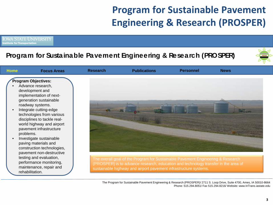
Program Objectives:• Advance research,
development and implementation of next-generation sustainable roadway systems.
• Integrate cutting-edge technologies from various disciplines to tackle real-world highway and airport pavement infrastructure problems.
• Investigate sustainable paving materials and construction technologies, pavement non-destructive testing and evaluation, performance monitoring, maintenance, repair and rehabilitation.
The overall goal of the Program for Sustainable Pavement Engineering & Research (PROSPER) is to advance research, education and technology transfer in the area of sustainable highway and airport pavement infrastructure systems.

PROSPER (Cont’d)
4
Program for Sustainable Pavement Engineering & Research (PROSPER)
Home Focus Areas Research Publications Personnel
The Program for Sustainable Pavement Engineering & Research (PROSPER)/ 2711 S. Loop Drive, Suite 4700, Ames, IA 50010-8664Phone: 515.294.8051/ Fax 515.294.8216/ Website: www.InTrans.iastate.edu
NewsNon-Destructive
Testing & Evaluation
Sustainable Construction Materials &
Technologies
Mechanistic-based Pavement
Analysis & Design
Advanced Health
Monitoring & Management
Intelligent Systems
Engineering
Economic and Environmental
Assessment
Highways, Airport
Pavements, Paved &
Unpaved roads
Education & Technology
Transfer
PROSPER (Cont’d)
5
Program for Sustainable Pavement Engineering & Research (PROSPER)
Home Focus Areas Research Publications Personnel
The Program for Sustainable Pavement Engineering & Research (PROSPER)/ 2711 S. Loop Drive, Suite 4700, Ames, IA 50010-8664Phone: 515.294.8051/ Fax 515.294.8216/ Website: www.InTrans.iastate.edu
News
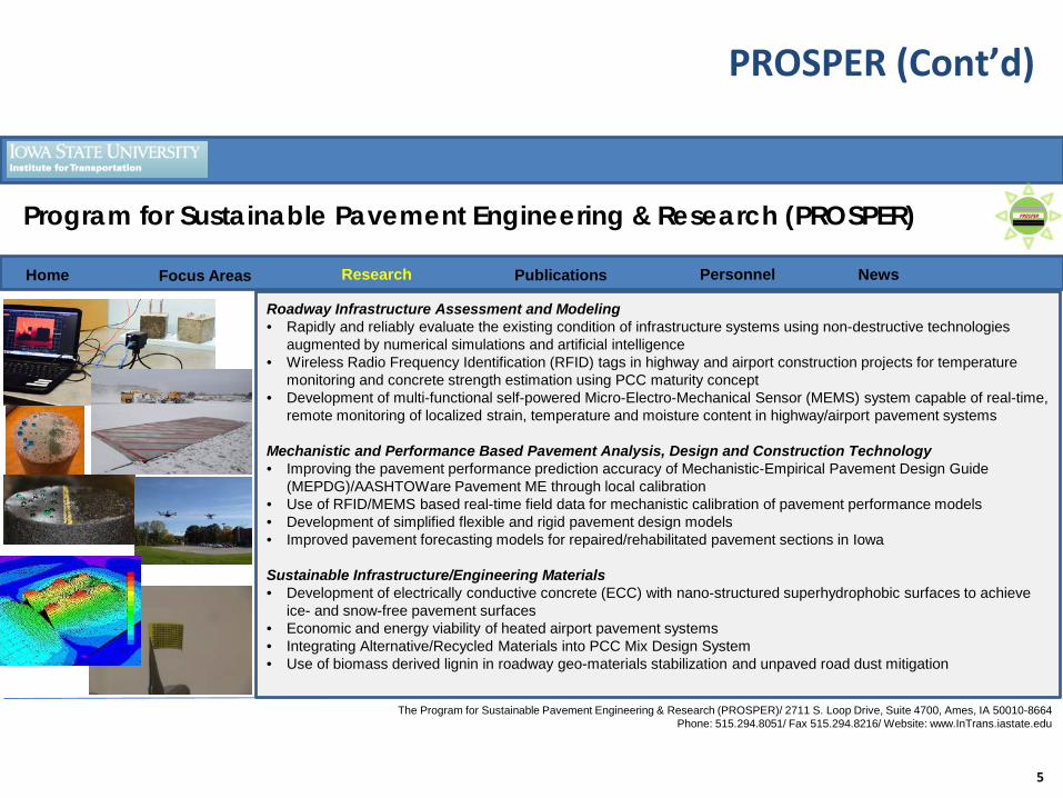
Roadway Infrastructure Assessment and Modeling• Rapidly and reliably evaluate the existing condition of infrastructure systems using non-destructive technologies
augmented by numerical simulations and artificial intelligence• Wireless Radio Frequency Identification (RFID) tags in highway and airport construction projects for temperature
monitoring and concrete strength estimation using PCC maturity concept• Development of multi-functional self-powered Micro-Electro-Mechanical Sensor (MEMS) system capable of real-time,
remote monitoring of localized strain, temperature and moisture content in highway/airport pavement systems
Mechanistic and Performance Based Pavement Analysis, Design and Construction Technology• Improving the pavement performance prediction accuracy of Mechanistic-Empirical Pavement Design Guide
(MEPDG)/AASHTOWare Pavement ME through local calibration• Use of RFID/MEMS based real-time field data for mechanistic calibration of pavement performance models• Development of simplified flexible and rigid pavement design models• Improved pavement forecasting models for repaired/rehabilitated pavement sections in Iowa
Sustainable Infrastructure/Engineering Materials• Development of electrically conductive concrete (ECC) with nano-structured superhydrophobic surfaces to achieve
ice- and snow-free pavement surfaces• Economic and energy viability of heated airport pavement systems• Integrating Alternative/Recycled Materials into PCC Mix Design System• Use of biomass derived lignin in roadway geo-materials stabilization and unpaved road dust mitigation

PROSPER (Cont’d)
6
Program for Sustainable Pavement Engineering & Research (PROSPER)
Home Focus Areas Research Publications Personnel News
Halil Ceylan, Ph.D., Director, PROSPER• 93 research projects, serving as PI or Co-PI
–Over $13.5 million of cumulative research funds (over $16.1 million project funds including matching funds)
–Sponsored by the FHWA, the FAA, NSF, NCHRP, SHRP 2, IA DOT, IHRB, MN DOT, MN LRRB, PCA, GIVF, and other funding agencies
• Over 230 technical publications authored
• Over 230 invited presentations and technical lectures with several keynote lectures
• More than 20 national and international technical committees and organizations
PROSPER (Cont’d)
7
Program for Sustainable Pavement Engineering & Research (PROSPER)
Home Focus Areas Research Publications Personnel News
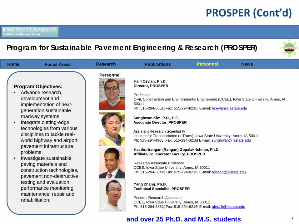
PersonnelHalil Ceylan, Ph.D.Director, PROSPER
ProfessorCivil, Construction and Environmental Engineering (CCEE), Iowa State University, Ames, IA 50011Ph: 515-294-8051| Fax: 515-294-8216| E-mail: [email protected]
Kasthurirangan (Rangan) Gopalakrishnan, Ph.D.Affiliate/Collaborator Faculty, PROSPER
Research Associate ProfessorCCEE, Iowa State University, Ames, IA 50011Ph: 515-294-3044| Fax: 515-294-8216| E-mail: [email protected]
Sunghwan Kim, P.D., P.E.Associate Director, PROSPER
Assistant Research Scientist IV Institute for Transportation (InTrans), Iowa State University, Ames, IA 50011Ph: 515-294-4968| Fax: 515-294-8216| E-mail: [email protected]
Program Objectives:• Advance research,
development and implementation of next-generation sustainable roadway systems.
• Integrate cutting-edge technologies from various disciplines to tackle real-world highway and airport pavement infrastructure problems.
• Investigate sustainable paving materials and construction technologies, pavement non-destructive testing and evaluation, performance monitoring, maintenance, repair and rehabilitation.
and over 25 Ph.D. and M.S. students
Yang Zhang, Ph.D.Technical Specialist, PROSPER
Postdoc Research Associate CCEE, Iowa State University, Ames, IA 50011Ph: 515-294-8852| Fax: 515-294-8216| E-mail: [email protected]

InfraDrone
• Iowa startup pioneered by ISU students
8

Outline
• Introduction
• Summary of Previous Studies
• Vision and Approaches
• Proof of Concept
• Applications
• Summary
9

Welcome to the World of UAVs/UASs!
• An Unmanned Aircraft System (UAS) is a system:– Unmanned Aircraft– Ground Control Station– Command & Control Link(s)
•Also known as:– Unmanned Aerial Vehicle (UAV)– Remotely Piloted Aircraft System (RPAS)– RC Model Aircraft– Drone
10

Welcome to the World of UAVs/UASs! (Cont’d)
11

Welcome to the World of UAVs/UASs! (Cont’d)
12
The White House Office of Science and Technology Policy (OSTP)
The First-Ever OSTP Workshop on Drones and the Future of Aviation

Welcome to the World of UAVs/UAS! (Cont’d)
•The White House OSTP announced a series of actions to promote the innovative adoption of UAS across the US:
13

Why Use a UAS?
•UAS operations are particularly effective for missions that are dangerous or dull
–Humans are not put at risk–Continuous operations are possible
•Operations with UAS often cost less than using manned aircraft
14
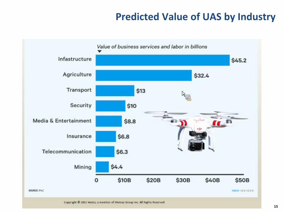
Predicted Value of UAS by Industry
15

UAS and Infrastructure Inspection/Monitoring
• Perform civil/transportation structural & functional health monitoring (S/FHM)
• Use a network of Unmanned Aircraft Systems (UAS)• Equipped with visual and non-destructive evaluation
(NDE) capabilities• Increased accuracy of UAS• Significantly reduce infrastructure monitoring costs• Testing can occur more frequently• Removes need to hinder regular operations during
testing • Ease of accessibility and navigation through complex
structures
16

Outline
• Introduction
• Summary of Previous Studies
• Vision and Approaches
• Proof of Concept
• Applications
• Summary
17

Summary of Previous DOT Studies
18
• Washington (2008)
• Weather data
• Seismic data
• Traffic surveillance
• Border security
• Avalanche control
• Utah DOT (2012)
• Construction monitoring
• Wetland plant species classification
• Georeferencing
• NIR and RGB
• Georgia DOT (2013)
• Real time digital photo and video of traffic scenes
• Aerial data in GDOT drawing software programs
• Operations with limited or restricted personnel access
• Michigan DOT (2014)
• Bridge condition assessment
• LiDAR
• Pump station inspection
• Live traffic monitoring
• Roadway asset detection
• Ohio DOT (2015)
• Dam inspection
• Crash investigation
• Forensic mapping
• Minnesota DOT (2015)
○ LiDAR roadway data
○ Bridge inspection
○ NIR imaging
○ Created employee UAS policy
And many universities (Michigan Tech, South Dakota State University, etc.)

Summary of Previous DOT Studies (Cont’d)
• Illinois Department of Transportation (IDOT)
19

Previous Case Study: UAV for Unpaved Road Assessment
• Funded by USDOT Commercial Remote Sensing and Spatial Information Program trough Office of the Assistant Secretary for Research and Technology (USDOT/OST-R)
• Executed by Michigan Tech University (PI: Colin N. Brooks)
• Phase I and Phase II were scoped, funded and completed by November 3th, 2016
– Phase I: enhance and develop an unpaved road assessment system– Phase II: a commercially-available, implemented system available to
transportation agencies
20
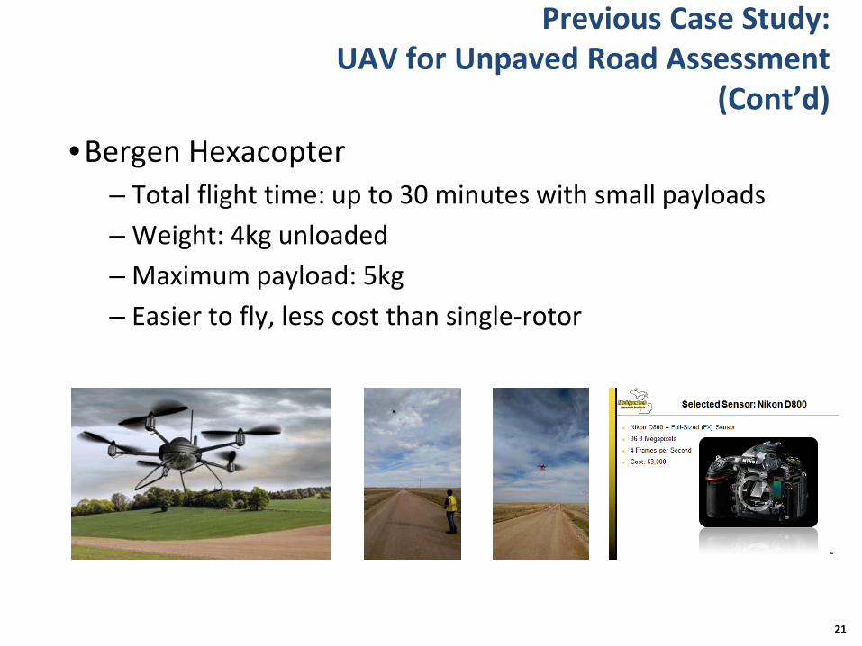
Previous Case Study: UAV for Unpaved Road Assessment
(Cont’d)•Bergen Hexacopter
– Total flight time: up to 30 minutes with small payloads – Weight: 4kg unloaded– Maximum payload: 5kg– Easier to fly, less cost than single-rotor
21

Previous Case Study: UAV for Unpaved Road Assessment
(Cont’d)•Field tests on Welch road, Michigan
22
Potholes, washboarding(corrugation) and float aggregate on test section Aerial view of the test section
3-D point cloud generated by the remote sensing processing system
3-D height map showing pothole distresses

Previous Case Study: UAV for Unpaved Road Assessment
(Cont’d)
•UAV, high-resolution camera, and good-quality lens– Cost per mile rated $30,590/yr/1575 mile/yr = $19.42/mile rated
– HOWEVER…two 100-foot measured segments represent one mile of road, so 5,280 ft/200ft is 26.4
– Therefore each mile of measured road represents a road network 26 times larger
– Therefore cost is $0.74 per mile (= $19.42/mile dived by 26)
23

Previous Case Study: UAV for Bridge Inspections
•Phase I project was scoped, funded and completed by June 30th, 2015
•Phases II and III are underway•Evaluate UAV’s safety and effectiveness for bridge
inspection•Capabilities and effectiveness in improving
inspections and reducing inspection costs•Fly without GPS, under bridge decks•Photo, Video and Thermal Imaging
24

Previous Case Study: UAV for Bridge Inspections (Cont’d)
•Bridge 13509 – Chisago County– Small Local Bridge– Prestressed Concrete Beam Bridge– Unable to fly under bridge– Infrared images– Orthographic Mapping
25

Previous Case Study: UAV for Bridge Inspections (Cont’d)
•Bridge 448 – Oronoco Bridge– Historical Concrete Arch Bridge– Prestressed Concrete Beam Approaches– Unable to fly under bridge– Able to fly in rain
26

Previous Case Study: UAV for Bridge Inspections (Cont’d)
•Bridge 49553 –Morrison County Pedestrian Bridge–Large Steel Truss–Great detail in images–Pack rust visible–Concrete deterioration visible
27
Previous Case Study: UAV for Bridge Inspections (Cont’d)
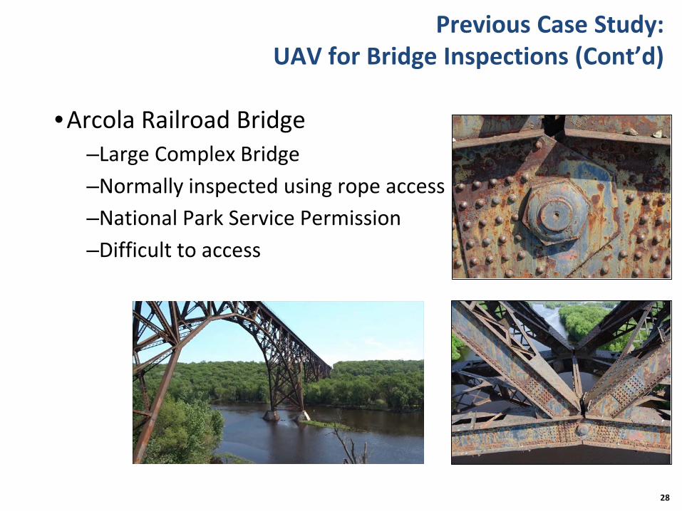
•Arcola Railroad Bridge–Large Complex Bridge–Normally inspected using rope access–National Park Service Permission–Difficult to access
28

Previous Case Study: UAV for Bridge Inspections (Cont’d)
•Nielsville Bridge 5767–Infrared Imaging–Thermal Camera results were similar to high end Flircameras
–Drone has the ability to map chain drag markings for quantities in CAD
29

Previous Case Study: UAV for Bridge Inspections (Cont’d)
• UAVs can be used in the field during bridge inspections safely.
• Image quality allows for the identification of defects• Tactile functions cannot be replicated using UAVs• UAVs can be cost effective • UAVs can provide a very efficient way to collect infrared
images • Safety risks could be minimized with the use of UAVs• UAVs can be utilized to determine channel conditions• UAVs can provide important pre-inspection information• “Off the shelf” UAV’s have limited inspection capability• Phases II and III are underway
30

“Small UAS” Rule: FAA Part 107 for Small UAS
• UAS must be within line of sight• Daylight and twilight flights allowed• Max height < 400 feet above
structure• Max speed < 100 mph • UAV weight < 55 lbs• Cannot fly directly over airports• Remote pilot airman certificate to fly• UAS must be registered with FAA
31
First national, uniform guidelines for non-recreational operation of UAS under 55 pounds (July – August 2016)

Outline
• Introduction
• Summary of Previous Studies
• Vision and Approaches
• Proof of Concept
• Applications
• Summary
32

Vision
•Monitor multiple structures with UAS: Pilot studies–Road infrastructure (pavements and gravel roads) –Bridges –Energy infrastructure–Hazardous locations
33

Vision (Cont’d)
•Design UAS with multipurpose & modular design•Validate precision control and navigation of UAV• Incorporate NDT and visual monitoring equipment
into UAV• Infrastructure HM&M using developed UAS
34

Approaches
•Different UAS for different purpose:–Fixed Wing–Light Quadcopter–Heavy-lift Hexacopter
•Retrofit sensors on UAS based on task:–3D rendering & virtual reconstruction–HD visual inspection–Mobile LiDAR–Infrared thermal camera–NDE probes
35

Approaches (Cont’d)
•Proposed systems architecture
36

Capabilities: Fixed Wing UAV Design -Phantom FPV Flying Wing EPO Airplane
•Wingspan: 1,550 mm•Motor: 900 kv brushless•Endurance: 45 min•Cruise speed: 40 mph•FPV camera attachable•Hero5 GoPro equipped
37
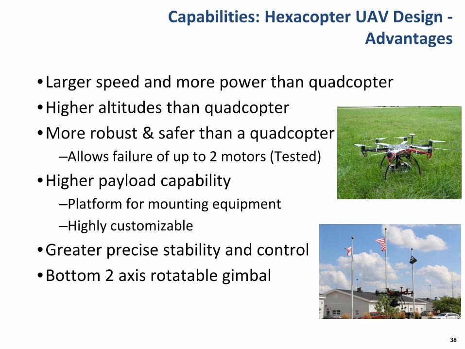
Capabilities: Hexacopter UAV Design -Advantages
•Larger speed and more power than quadcopter•Higher altitudes than quadcopter•More robust & safer than a quadcopter
–Allows failure of up to 2 motors (Tested)
•Higher payload capability–Platform for mounting equipment–Highly customizable
•Greater precise stability and control•Bottom 2 axis rotatable gimbal
38
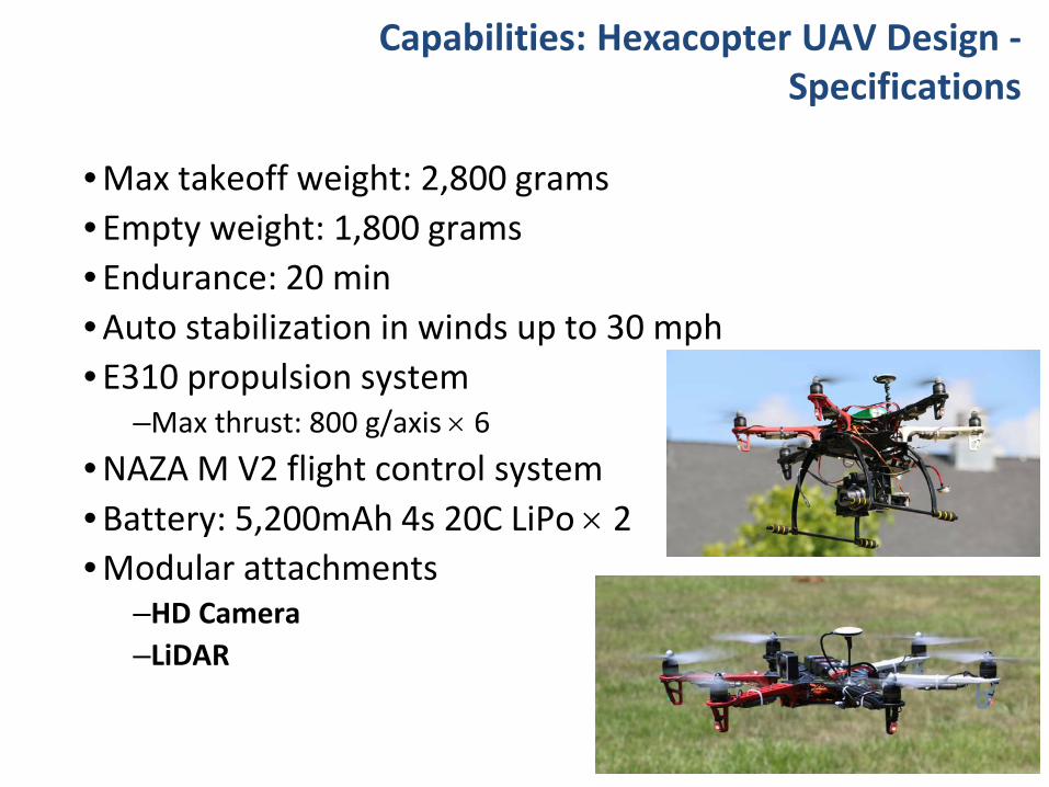
Capabilities: Hexacopter UAV Design -Specifications
• Max takeoff weight: 2,800 grams• Empty weight: 1,800 grams• Endurance: 20 min• Auto stabilization in winds up to 30 mph• E310 propulsion system
–Max thrust: 800 g/axis × 6• NAZA M V2 flight control system• Battery: 5,200mAh 4s 20C LiPo × 2• Modular attachments
–HD Camera–LiDAR
39

Capabilities: Hexacopter UAV Design -Systems Integration
40

Capabilities: Hexacopter UAV Design -Systems Integration (Cont’d)
41

Outline
• Introduction
• Summary of Previous Studies
• Vision and Approaches
• Proof of Concept
• Applications
• Summary
42

Proof of Concept: Overview
43
3D Rendering & Virtual
Reconstruction
High Definition Visual
Inspection
Infrared Thermography
LiDAR
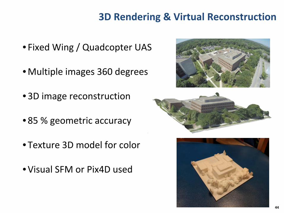
3D Rendering & Virtual Reconstruction
• Fixed Wing / Quadcopter UAS
• Multiple images 360 degrees
• 3D image reconstruction
• 85 % geometric accuracy
• Texture 3D model for color
• Visual SFM or Pix4D used
44

3D Rendering & Virtual Reconstruction (Cont’d)
• ISU Town Engineering Building
45
Image CollectionApprox 60 pics
Solid Mesh
Dense Point Cloud
3D Printing
Final Texture Render

3D Rendering & Virtual Reconstruction (Cont’d)
• Iowa DOT complex (August 8, 2016)
46

3D Rendering & Virtual Reconstruction (Cont’d)
• Iowa DOT complex (August 8, 2016)
47
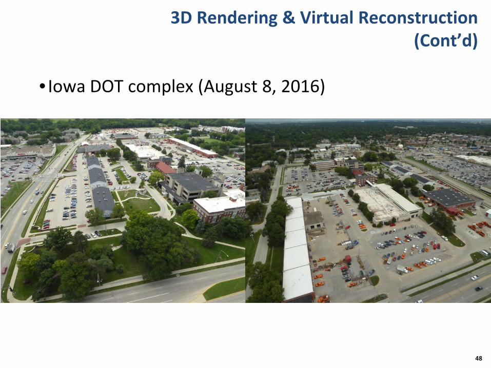
3D Rendering & Virtual Reconstruction (Cont’d)
• Iowa DOT complex (August 8, 2016)
48

3D Rendering & Virtual Reconstruction (Cont’d)
• Iowa DOT complex: final render
49

3D Rendering & Virtual Reconstruction (Cont’d)
•3D rendering potential applications
50

High Definition Visual Inspection
•HD camera payload•Live transmission•Close up images•Pre-plan flight• Image processing:
–BHT–HSV–P-Color threshold
51
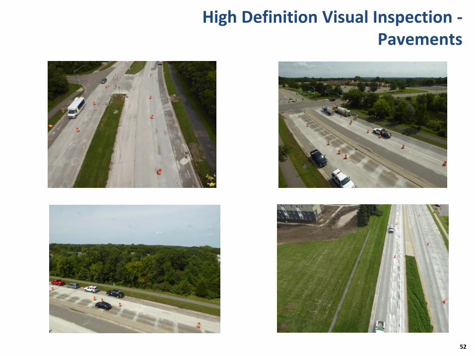
High Definition Visual Inspection -Pavements
52

High Definition Visual Inspection –Pavements (Cont’d)
53

High Definition Visual Inspection –Pavements (Cont’d)
54
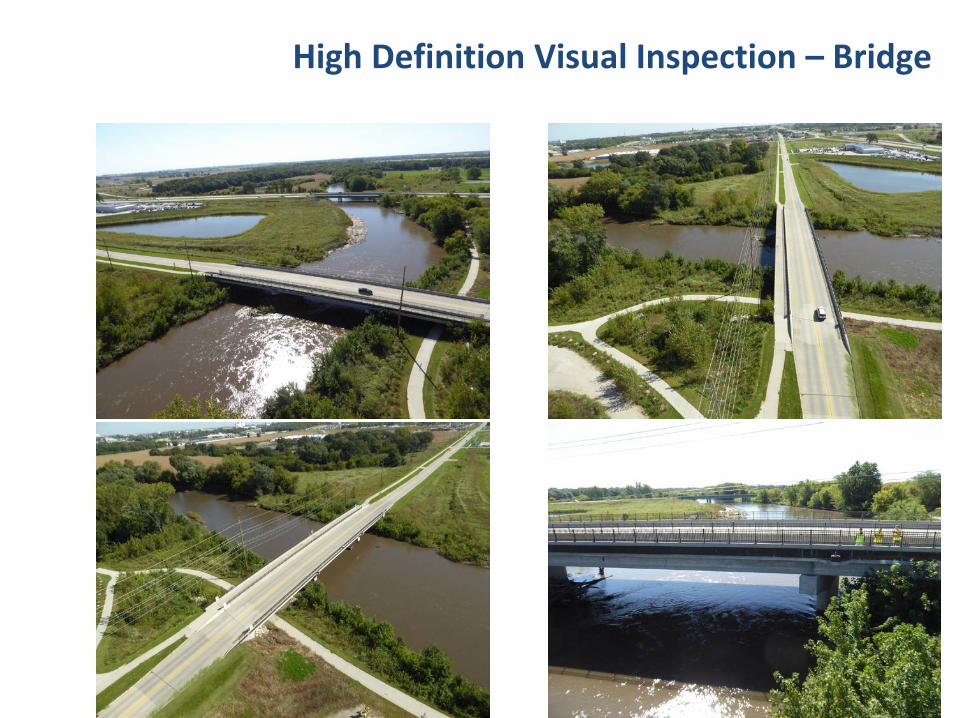
High Definition Visual Inspection – Bridge
55

High Definition Visual Inspection – Bridge (Cont’d)
56

High Definition Visual Inspection – Bridge (Cont’d)
57
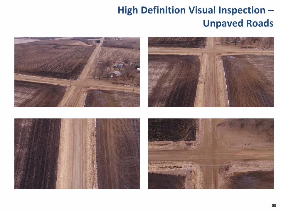
High Definition Visual Inspection –Unpaved Roads
58
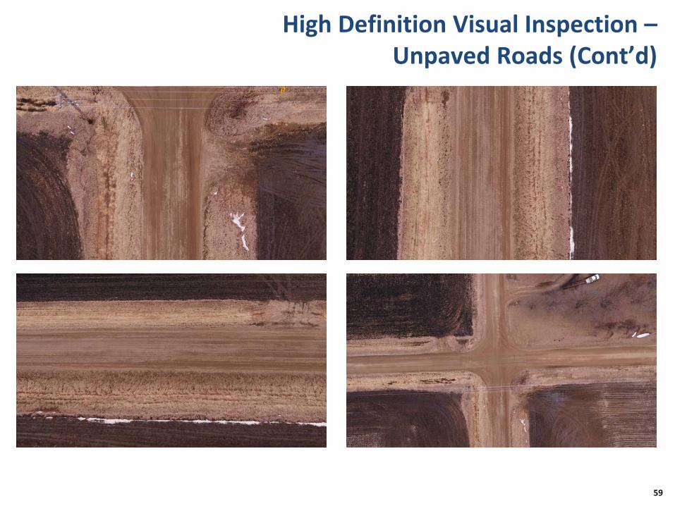
High Definition Visual Inspection –Unpaved Roads (Cont’d)
59
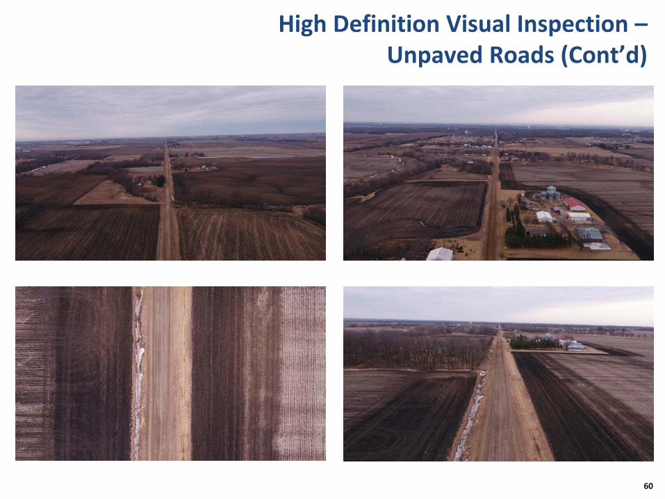
High Definition Visual Inspection –Unpaved Roads (Cont’d)
60

High Definition Visual Inspection – Power Lines
61
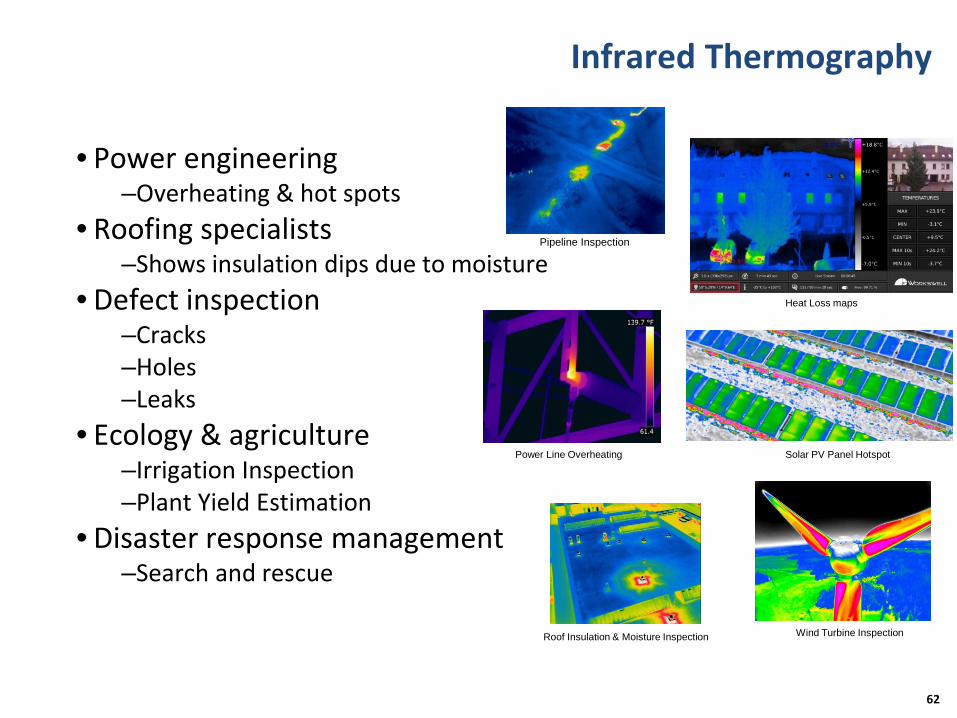
Infrared Thermography
• Power engineering–Overheating & hot spots
• Roofing specialists–Shows insulation dips due to moisture
• Defect inspection–Cracks–Holes–Leaks
• Ecology & agriculture–Irrigation Inspection–Plant Yield Estimation
• Disaster response management–Search and rescue
62
Power Line Overheating Solar PV Panel Hotspot
Roof Insulation & Moisture Inspection Wind Turbine Inspection
Pipeline Inspection
Heat Loss maps

Light Detection and Ranging (LiDAR)
• Surface condition survey
• Crack detection
• 3D pothole geometry
• Grade model
• Rut model
• Digital Elevation Model (DEM)
• Building elevation model
63
Road Top View
Road Side View
Digital Elevation Model

LiDAR - Example Scan Results
64
ForestryPower Lines Inspection (Top & Bottom)
Mining Survey

Other: Robotic Arm Extender
• Payload for Hexacopter-II UAV • Holds ultrasound equipment• Arm end holds transducer• Easy to maneuver around• 360 degree 3 axis movement • Extendable reach on walls• Allows safe distance b/w wall &
UAV• Controlled manually by ground
station
65

Outline
• Introduction
• Summary of Previous Studies
• Vision and Approaches
• Proof of Concept
• Applications
• Summary
66

Application: Transportation Infrastructure Inspection
• Crack detection and inspection
• Crack depth analysis
• Rut and pothole detection
• Delamination detection
• Sight distance, slope, grade, and contour models
• Pipeline inspection associated with roadways
• 3D photogrammetric, LiDAR model and thermal image model
67

Application: Building Inspection
• Aerial construction monitoring & management
• Structural health monitoring
• 3D construction time lapse
• Structural warping recognition
• Crack detection and inspection
• Crack depth analysis
• 3D photogrammetric and LiDAR model
68

Application: Disaster Management
• Visual location of victims
• Aerial damage assessment
• UAV resource (food/water) delivery
• Medical first aid kit delivery
• LiDAR damage assessment
• 3D flood modelling using DEM
69

Application: Underwater Structural Inspections
• Underwater drones may be developed
• Dam & bridge scour inspections
• Underwater visual monitoring
• 2D & 3D image reconstruction
• Underwater acoustic images
• Underwater LiDAR & SONAR used
• Low risk & cost effective
70

Application: Construction Safety Assessment
• A tool to assist the field inspector
• Safety of traveling public– Temporary traffic control measures– Temporary markings (alignment/visibility)– Entrance and exit of work vehicles into traffic
• Safety of contractor– Potential OSHA violations– Improper construction practices
• Capture traffic movement during peak hours
• Capture traffic during temporary traffic control set up and removal
• Review all footage and images
71

Application: Accident Reconstruction
•Use a drone to capture data to reconstruct an accident scene
•Meet existing accuracy requirements
•Open roads to traffic quicker
•Minimize exposure of accident personnel to traffic
72

Application: Others
• Aggregate stockpile
•Assess loss and damage after fire, wind, water, and hail events
•Energy infrastructure inspection (electric powerlines, solar panels, oil pipelines, wind turbines, etc.)
73

Outline
• Introduction
• Summary of Previous Studies
• Vision and Approaches
• Proof of Concept
• Applications
• Summary
74

Summary
•Positive impact will be massive on industry
•UAS can contribute to a new era of civil infrastructure health monitoring
•Helps inspectors become more efficient
•Applications span across multiple industries
•Lower cost, time and risks involved
75

Summary (Cont’d)
•Use of UAVs in transportation engineering and asset management is revolutionary innovation and a paradigm shift in finding targeted solutions for Iowa's transportation future!
76

References
• The White House OSTP Workshop on Drones and the Future of Aviation
• FHWA Construction Webinar: Unmanned Aerial Systems (UAS)
• FAA Fact Sheet – Small Unmanned Aircraft Regulations (Part 107)
• Brooks et al. (2016). Characterization of Unpaved Road Conditions through the Use of Remote Sensing, http://mtri.org/unpaved/
• Lovelace (2017). Unmanned Aircraft System Bridge Inspection Demonstration Project, http://dot.state.mn.us/research/reports/2017/201718.pdf
• Other related resources from web
77
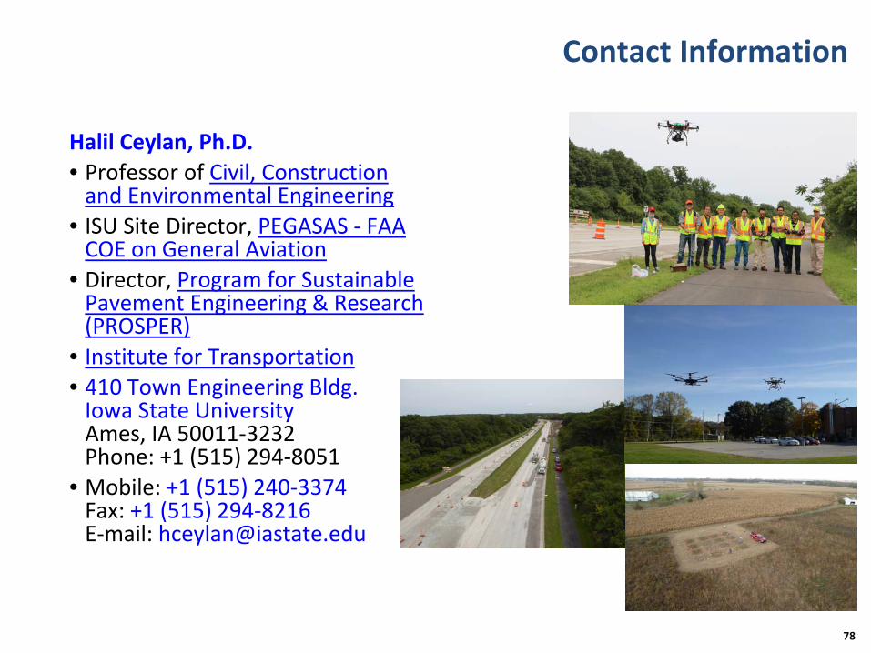
Contact Information
Halil Ceylan, Ph.D.• Professor of Civil, Construction
and Environmental Engineering• ISU Site Director, PEGASAS - FAA
COE on General Aviation• Director, Program for Sustainable
Pavement Engineering & Research (PROSPER)
• Institute for Transportation• 410 Town Engineering Bldg.
Iowa State UniversityAmes, IA 50011-3232Phone: +1 (515) 294-8051
• Mobile: +1 (515) 240-3374Fax: +1 (515) 294-8216E-mail: [email protected]
78

Thank You!Questions & Comments?

80
• Extra slides
• Are you ready to ride on drones?

81(source: http://www.ehang.com/)

82(source: http://www.ehang.com/)
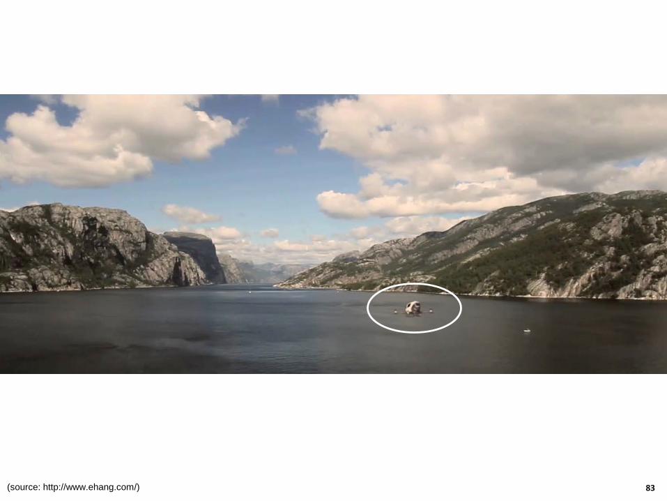
83(source: http://www.ehang.com/)

84(source: http://www.ehang.com/)

85(source: http://www.ehang.com/)

86(source: http://www.ehang.com/)

87(source: http://www.ehang.com/)

88(source: http://www.ehang.com/)
ISU PROSPER-Iowa DOT Unmanned Aerial Systems Research Partnership Meetings
• August 8 to 9, 2016, Iowa Department of Transportation Ames Complex, NW Wing, 2nd Floor Conference Room
• The purpose of the meetings was to inform Iowa DOT on the potential uses, capabilities and benefits of UAS or Drones for civil and transportation applications and the preliminary studies conducted by the ISU-PROSPER team so far in this regard
• An important outcome of both the meetings was the discussion among the attendees in identifying UAS applications and capabilities that are of interest and value to Iowa DOT
89

Highlights of Discussions: Infrastructure Health Monitoring and Management -
Bridges/Roadways/Unpaved Roads
• Live loading assessment and monitoring
• In-service inspection
• Impact assessment of flooding/extreme events
• Safety of infrastructure during emergency/collisions
• Monitoring of threats/vandalism
• Inspection of concrete box culverts and large-size girders
90
• Unpaved road condition assessment
• Calibration of roadway geometry
• Drainage assessment
• Erosion and sediment control assessment
• Bridge/roadway design support
• Condition of drill shafts (bridges)

Highlights of Discussions: Infrastructure Health Monitoring and Management -
Bridges/Roadways/Unpaved Roads (Cont’d)
91
• Surface integrity of bridge elements
• Inspection of out-of-plane bending of plates (bridge)
• Snow removal management
• Sealing of minor cracks (using UAS robotic arm)
• QC/QA for pavement analysis
• UAV-borne Electromagnetic Induction (EMI) and Ground Penetrating Radar (GPR) geophysical surveys
• Inspect research gages
• Bridge scour inspections using SONAR (underwater UAS)
• Snow and ice removal crew tracking
• Monitor movement of rocks/sediments
• Monitor concrete pavement curling and warping
• Non-Destructive Evaluation (NDE) using UAS robotic arm

92
• Bridge deck delamination (infrared)
• Spall detection
Highlights of Discussions: Infrastructure Health Monitoring and Management -
Bridges/Roadways/Unpaved Roads (Cont’d)
Highlights of Discussions: Planning and Construction
• Construction inspection
• Construction project documentation
• Construction/materials estimation on site/stockpiles
• Assessment of grading progress
93
• Monitor construction progress (4-D)
• Rebar inspection in congested areas
• Airport obstruction analysis
• Site evaluation/exploratory
• Confined space inspection
Highlights of Discussions: Surveying/Photogrammetry
• As-built surveying
• Deriving Digital Elevation Models (DEMs)
• Deriving Digital Terrain Models (DTMs)
94
• Estimation of amount and type of fill material required for repairs from digital surface models
• Project-specific small-scale Photogrammetry

Highlights of Discussions: Asset Management
95
• Inventory of bridges and related assets
• Inspection of roadway assets
• Inspections of pump stations
• Inspection of high mast lighting poles (HML)
• Roadside condition and inventory surveys
• Dam inspection
• Wetland survey/mitigation
• Pavement reflectivity

Highlights of Discussions: Asset Management (Cont’d)
96
• Inspections of entrances to sewers and culverts
• Pavement condition surveys
• Surface type inventory
• Pavement marking retroreflectivity
• Tracking/monitoring traffic control devices

Highlights of Discussions: Traffic
97
• Live traffic monitoring and control
• Work zone management
• Traffic data collection
• Incident management
• Real-time traffic impact assessment
• Monitoring congestion of roadways
• Monitoring activities at traffic intersections
• Assessment of traffic patterns

Highlights of Discussions: Traffic (Cont’d)
98
• Crash investigation
• Forensic mapping
• Support Intelligent Transportation
• System (ITS) application of highway and transportation infrastructure monitoring
• Urban highway traffic monitoring
• Level of Service (LOS) determination
• Estimation of average annual daily travel
• Measuring origin-destination flows
• Traffic-related pollution monitoring

Highlights of Discussions: Other Topics
99
• Avalanche control on mountain slopes
• Mapping snow depths
• Landslide investigations/mapping
• Geomorphological mapping
• Disaster response
• Migration monitoring and stewardship
• Forest mapping
• Search and rescue operations
• Downscaling NASA satellite images
• Soil moisture (drought, fire)
• Identifying ecological impacts of climate or land-use change
• Modeling flood-beds (4-D dynamic modeling)
Highlights of Discussions: Other Topics (Cont’d)
100
• State and local emergency management
• Precision surveying and mapping
• Wetland plant species classification
• Risk management
• Classification of vegetation cover and type
• Inspection of quarries and pits
• Facilities management
• Rangeland health determinations
• Homeland security
• Law enforcement

101
• Monitoring plant phenology
• Identifying locations of potentially erosive soils
• Measuring gaps between vegetation patches
• Environmental impact assessment
• Decision support for transportation planning, operations, maintenance and program development
Highlights of Discussions: Other Topics (Cont’d)

Highlights of Discussions: 2017 CERFG
• UAS related research topics selected from the 2017 County Engineers Research Focus Group Meeting (CERFG)
– Three UAS related topics made the top 5 list based on the prioritization and votes cast by the Iowa County Engineers among some 30 potential proposed research topics
•Use of Unmanned Aerial Vehicles in Surveying and Construction Works for Iowa Transportation Infrastructure System (No. 1, 16 votes)• Use of Unmanned Aerial Systems for Health Monitoring and Condition Assessment of Iowa Low Volume Road and Bridge Infrastructure Systems (No. 3, 13 votes)• Unmanned Aerial Vehicles based Traffic Sign Inventory and Condition Assessment (No. 4, 9 votes)
102
Recommended