City of Surrey PLANNING & DEVELOPMENT REPORT
File: 7909-0113-00
Planning Report Date: September 14, 2009
PROPOSAL:
Development Permit
Development Variance Permit
in order to permit the development of a new 843 sq.m. (9,074 sq.ft.) two-storey Fire Hall replacing the existing one on the subject site. A DVP for reduced front and side yard setbacks, and to waive site servicing requirements.
LOCATION: 2016 - 176 St. and 17631 - 20 Ave.
OWNER: City of Surrey
ZONING: RA
OCP DESIGNATION: Rural
LAP DESIGNATION: Suburban Residential

Staff Report to Council File: 7909-0113-00
Planning & Development Report
Page 2
RECOMMENDATION SUMMARY
Approval to draft Development Permit.
Approval for Development Variance Permit to proceed to Public Notification.
DEVIATION FROM PLANS, POLICIES OR REGULATIONS
The proposal requires a Development Variance Permit (DVP) for reduced front and side yard
setbacks.
The proposal also requires a DVP to relax the Subdivision & Development By-law to waive site
servicing requirements including the conditions to provide vehicular highway systems, water
supply, and sanitary sewer.
RATIONALE OF RECOMMENDATION
The proposed building form is appropriate for this part of Southeast Surrey and meets the design
guidelines of the Development Permit Area.
The proposed DVP for reduced setbacks is necessary to allow for tree preservation on the site.
Currently, there is no servicing available to the subject site. Due to the nature of the use and the
limited number of occupants, the Engineering Department has determined that the existing road
infrastructure and water supply are adequate for the proposed development. An on-site private
sewage system will be constructed to service this development.
Sustainable design strategies will be incorporated into this development including 20% reduction
of potable water and 25% reduction of energy. It is expected that the proposed development will
meet the equivalent standards of LEED Silver.

Staff Report to Council File: 7909-0113-00
Planning & Development Report
Page 3
RECOMMENDATION
The Planning & Development Department recommends that:
1. Council authorize staff to draft Development Permit No. 7909-0113-00 generally in accordance
with the attached drawings (Appendix II).
2. Council approve Development Variance Permit No. 7909-0113-00 (Appendix V) varying the
following, to proceed to Public Notification:
(a) In Section A.1 (a) iv of Part 4 General Provisions in the Zoning By-law, 1993,
No. 12000, as amended, to reduce the minimum north side yard setback from 9.0 metres
(30 feet) to 4.5 metres (15 feet);
(b) In Section A.1 (a) iv of Part 4 General Provisions in the Zoning By-law, 1993,
No. 12000, as amended, to reduce the minimum south side yard setback (flanking street)
from 9.0 metres (30 feet) to 4.4 metres (14.4 feet) to the building face, and 2.9 metres
(9.5 feet) to the edge of the pond structure and 2.4 metres (8 feet) to the edge of the roof
structure;
(c) In Section A.1 (a) iv of Part 4 General Provisions in the Zoning By-law, 1993,
No. 12000, as amended, to reduce the minimum front yard setback (176 Street) from
9.0 metres (30 feet) to 8.5 metres (28 feet) to the building face, 7.5 metres (25 feet) to the
edge of the roof structure and 4.3 metres (14 feet) to the edge of the brick wall; and
(d) In Section 24 (a) of Part 5 Highway Dedication, Servicing and Construction Standards of
the Surrey Subdivision and Development By-law, 1986, No. 8830, the requirement to
provide vehicular highway systems, water supply and sanitary sewer is waived.
REFERRALS
Engineering: The Engineering Department has no objection to the project
subject to the completion of Engineering servicing requirements as
outlined in Appendix III prior to the issuance of a Building Permit.
Ministry of Transportation
& Infrastructure (MOTI):
No concerns. The proposed access to 176 Street (Highway 15) is
acceptable as proposed.
Soil Contamination Branch
Ministry of Environment
(MOE):
No concerns. The applicant is required to complete an
independent remediation of the site under MOE's administrative
guidance prior to the issuance of a Building Permit.
Parks, Recreation &
Culture Department:
No concerns.

Staff Report to Council File: 7909-0113-00
Planning & Development Report
Page 4
SITE CHARACTERISTICS
Existing Land Use: Fire Hall #14.
Adjacent Area:
Direction Existing Use OCP/LAP Designation Existing
Zone
North and East:
Single family residences. Rural RA
South (Across 20 Avenue ):
Single family residences
and the Heritage Redwood
Park.
Rural/Suburban and Open
Space
RA
West (Across 176 Street):
Closed heritage school
property (Grandview
Heights Elementary School
Annex).
Suburban/Institutional RA
DEVELOPMENT CONSIDERATIONS
Background
The City of Surrey is proposing to construct a new Fire Hall #14, replacing the existing structure that
currently occupies the site. Currently, the Fire Hall is operated by volunteer firefighters and it is the
intention of the Surrey Fire Service that this Fire Hall will transition to a full-time staffed Fire Hall
by 2011. The Fire Hall is intended to serve the growing Southeast Surrey area.
In the fall of 2009, the City of Surrey plans to demolish the existing Fire Hall. In order not to disrupt
fire service to the area, the Fire Hall will be temporarily relocated to the Grandview School property
across Highway No. 15 (176 Street) at 17561- 20 Avenue. Since the proposed relocation will be
within the existing Grandview School property buildings, this temporary relocation is exempt from
City approvals. To protect the fire trucks from vandalism, temporary steel pre-fabricated buildings
will be placed in the parking area of the school property to house the fire trucks. These buildings will
not have any electrical or water supply and will be removed once the new Fire Hall #14 is
constructed and ready for occupancy in 2010. The transition from a volunteer to a full-time staffed
Fire Hall is expected to occur in the months following the final completion of the new Fire Hall
building.
The proposed two-storey 843 sq.m. (9,074 sq.ft.) Fire Hall will be sited facing Highway No. 15 (176
Street). The Fire Hall will contain a large apparatus bay to accommodate three fire trucks,
administrative and living space, and a parking area at the rear of the building.
Zoning By-law Compliance
The Surrey Zoning By-law permits public facilities such as Fire Halls, to be located in any zone,
provided that all minimum setbacks are equal or greater than either the height of the principal
building or the setbacks prescribed in the underlying zone.
Staff Report to Council File: 7909-0113-00
Planning & Development Report
Page 5
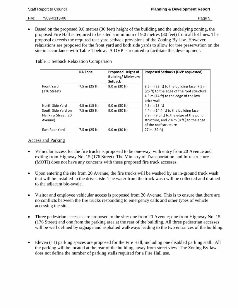
Based on the proposed 9.0 metres (30 feet) height of the building and the underlying zoning, the
proposed Fire Hall is required to be sited a minimum of 9.0 metres (30 feet) from all lot lines. The
proposal exceeds the required rear yard setback provisions of the Zoning By-law. However,
relaxations are proposed for the front yard and both side yards to allow for tree preservation on the
site in accordance with Table 1 below. A DVP is required to facilitate this development.
Table 1: Setback Relaxation Comparison
RA Zone Proposed Height of
Building/ Minimum Setback
Proposed Setbacks (DVP requested)
Front Yard (176 Street)
7.5 m (25 ft) 9.0 m (30 ft) 8.5 m (28 ft) to the building face; 7.5 m (25 ft) to the edge of the roof structure; 4.3 m (14 ft) to the edge of the low brick wall
North Side Yard 4.5 m (15 ft) 9.0 m (30 ft) 4.5 m (15 ft)
South Side Yard on Flanking Street (20 Avenue)
7.5 m (25 ft) 9.0 m (30 ft) 4.4 m (14.4 ft) to the building face; 2.9 m (9.5 ft) to the edge of the pond structure, and 2.4 m (8 ft.) to the edge of the roof structure
East Rear Yard 7.5 m (25 ft) 9.0 m (30 ft) 27 m (89 ft)
Access and Parking
Vehicular access for the fire trucks is proposed to be one-way, with entry from 20 Avenue and
exiting from Highway No. 15 (176 Street). The Ministry of Transportation and Infrastructure
(MOTI) does not have any concerns with these proposed fire truck accesses.
Upon entering the site from 20 Avenue, the fire trucks will be washed by an in-ground truck wash
that will be installed in the drive aisle. The water from the truck wash will be collected and drained
to the adjacent bio-swale.
Visitor and employee vehicular access is proposed from 20 Avenue. This is to ensure that there are
no conflicts between the fire trucks responding to emergency calls and other types of vehicle
accessing the site.
Three pedestrian accesses are proposed to the site: one from 20 Avenue; one from Highway No. 15
(176 Street) and one from the parking area at the rear of the building. All three pedestrian accesses
will be well defined by signage and asphalted walkways leading to the two entrances of the building.
Eleven (11) parking spaces are proposed for the Fire Hall, including one disabled parking stall. All
the parking will be located at the rear of the building, away from street view. The Zoning By-law
does not define the number of parking stalls required for a Fire Hall use.

Staff Report to Council File: 7909-0113-00
Planning & Development Report
Page 6
Tree Preservation and Landscaping
Ken McKillop, Certified Arborist of Durante Kreuk Limited, prepared an Arborist Assessment for
the subject property (Appendix IV). The Arborist Assessment states that there are a total of 12
protected trees on the property. The following is a table providing the breakdown by tree species:
Table 2: Tree Preservation
Tree Species Total Number
of Trees Total Proposed for Retention
Total Proposed for Removal
Tree Condition
Douglas Fir 2 2 0 Good
Western Red Cedar 1 1 0 Good
Cottonwood 4 0 4 Fair
Alder 3 0 3 Fair/Poor
Cherry 1 0 1 Poor
Mountain Ash 1 1 0 Good
Total 12 4 8
Six (6) of the trees on the subject are non-retainable species consisting of Cottonwood, Alder and a
Cherry Tree. Since these trees are in fair and poor condition, the arborist assessment recommends
that they be removed. The remaining four (4) trees are very large (each over 100 cm in diameter) and
high value coniferous trees consisting of Douglas Fir, Western Red Cedar and a Mountain Ash Tree.
These trees are in good condition and have been recommended for retention. The proposed building
footprint and walkways have been adjusted to allow for the retention of these trees. A DVP for
reduced setbacks is required to accommodate the preservation of these trees.
In addition to the proposed tree retention, the existing mature cedar hedges that border the north
(side yard) and east (rear yard) property lines will be maintained to ensure that the neighbouring
residential properties have an adequate visual and noise buffer.
The applicant has proposed to replant 14 trees on the subject site. This meets the City’s requirements
for tree replacement. The new trees on the site will consist of Katsura, Cherry, Serviceberry, Witch
Hazel and Persian Ironwood. The tree planting will be complemented by a variety of ground cover
including shrubs and perennials such as Red-Twig Dogwood, Charles Albanel Rose and Infinity Rug
Beaded Iris.
Overall, substantial landscaping improvements are proposed for this development. Majority of the
existing asphalt and paved surfaces will be removed and replaced with the landscaping described
above. This landscaping conforms to the landscaping design guidelines in the Official Community
Plan (OCP).
PRE-NOTIFICATION
A Development Proposal Sign was installed on the site to inform adjacent property owners about the
proposed development. Staff did not receive any comments on this proposal as a result of the
Development Proposal Sign.
Staff Report to Council File: 7909-0113-00
Planning & Development Report
Page 7
According to Council policy, the mail-out of pre-notification letters is not a requirement for
Development Permit applications. Although not required, on July 15, 2009, the Surrey Fire Service
sent out letters to residents within 100 metres (328 feet) of the site to inform them about the Fire
Department’s development plans. The Surrey Fire Service did not receive any comments as a result
of this notification.
DESIGN PROPOSAL AND REVIEW
This application was not referred to the Advisory Design Panel (ADP), but was reviewed by City
Staff and found to be satisfactory. The proposed Development Permit was evaluated based on
compliance with the approved design guidelines in the OCP. It also meets the design guidelines of
the Development Permit Area.
The design, form and proposed colours of the proposed building is west coast contemporary but also
has elements of traditional fire hall designs. The contemporary, west coast elements include the
projection of the upper storey, the use of heavy timbers as a cladding material, exposed concrete and
large wooden supporting beams. The traditional fire hall elements include the large arched apparatus
bays and extensive use of red brick as a cladding material. A decorative flag pole is proposed to be
placed at an angle above the main entrance, enhancing the traditional fire hall elements of the
proposed building.
In accordance with the CPTED principle of “eyes on the street”, the building has been designed to
allow for natural surveillance of Highway No. 15 (176 Street) by the placement of a high activity
room (the fitness facility) facing onto the street. The windows that frame the fitness facility allow
natural light inside the building and are retractable to a courtyard facing the street.
LEED/ Sustainable Design Strategies
The proposed Fire Hall will shadow the LEED Certification program by addressing the same
sustainability concerns identified under the LEED Scorecard. It is expected that the proposed
development will meet the equivalent standards of LEED Silver Certification. These sustainability
features include site planning, drainage, water, energy, materials and indoor air quality (each feature
is described below).
Sustainable Site Planning
The new building will be located on the footprint of the existing building thus limiting the ecological
footprint of the development. Likewise, a substantial amount of paving and asphalted surfaces will
be removed and replaced with landscaped areas thus improving the permeability of the site.
The site planning allows for the retention of the four (4) large and mature coniferous trees on the
site.
Sustainable Drainage
The proposed building and truck wash are designed to have on-site retention and filtering of storm
water. All the waste water generated by the truck wash will be filtered through a bio-swale.
Staff Report to Council File: 7909-0113-00
Planning & Development Report
Page 8
A pond structure will be constructed on the south side of the building in order to store the storm
water generated on the site. Roof leaders will collect rain water and deposit it in the pond. Water
resistive landscaping will be used to filter the water in the pond and a fountain will ensure that there
is no standing water in order to prevent mosquito infestations.
Water and Energy Reduction
The proposed development will be designed to reduce the use of potable water by a minimum of
20% by the use of reduced flow fixtures with automatic shut-offs and in-ground landscape irrigation.
Energy will be reduced by a minimum of 25% with:
o the use of radiant in-slab heat generated in the Apparatus bays;
o all rooms being equipped with occupancy sensors;
o day light areas containing photocells;
o the use of white acrylic coated roof membranes to reflect solar energy and to provide a cool roof
surface; and
o increased thermal insulation to reduce heat loss in the building.
Materials and Indoor Air Quality
During the demolition of the existing Fire Hall, the recycling and salvaging of construction material
is proposed. The use of locally sourced materials with high recycled content will be used where
possible.
Mechanical ventilation systems will be designed to maximize ventilation of the building and the use
of user controlled natural ventilation is provided in the living quarters and high activity areas such as
the fitness facility.
Low emitting paints, coatings and floorings are proposed to be used in order to reduce the amount of
Volatile Organic Compounds (VOCs) emitted during the construction process.
Signage
Two fascia signs are proposed for the Fire Hall building consisting of non-illuminated individual
channel letters. One fascia sign will be placed facing Highway No. 15 (176 Street) above the canopy
and the second fascia sign will be placed facing 20 Avenue. No signage is proposed facing the
residential properties adjacent to this site.
All proposed signage meets the requirements of the City’s Sign By-law and will match the design
and character of the building.

Staff Report to Council File: 7909-0113-00
Planning & Development Report
Page 9
BY-LAW VARIANCE AND JUSTIFICATION
(a) Requested Variance:
To reduce the minimum north side yard setback from 9.0 m (30 ft) to 4.5 m (15 ft).
To reduce the minimum south side yard (Flanking Street - 20 Avenue) setback from 9.0 m
(30 ft) to 4.4 m (14.4 ft) to the building face, 2.9 m (9.5 ft) to the edge of the pond structure,
and 2.4 m (8 ft.) to the edge of the roof structure.
To reduce the minimum front yard (176 Street) setback from 9.0 m (30 ft) to 8.5 m (28 ft) to
the building face, 7.5 m (25 ft) to the edge of the roof structure and 4.3 m (14 ft) to the edge
of the low brick wall.
Justification for Variances:
Without compromising the development potential of the subject site and allowing optimal
utilization of the site, the proposed variances will allow for the preservation of four
significant coniferous trees on the site. The reduced setbacks will be augmented by
substantially landscaped areas.
It is also anticipated that the proposed setback relaxations will not have any negative impacts
on the neighbouring properties. The setbacks to the neighbouring properties remain
unchanged.
(b) Requested Variance:
To waive the requirement to provide vehicular highway systems, water supply and sanitary
sewer.
Justification for Variance:
Due to the location of the site in a rural area of Surrey, there is currently no servicing
available for this site. The Engineering Department evaluated the proposed use and due to
the limited number of expected occupants, it was determined that the existing road
infrastructure and water supply were sufficient for the proposed development.
An on-site private sewage system will be constructed to service this development. The
private sewage system will be designed to meet the requirements of the Ministry of
Environment and Fraser Health.

Staff Report to Council File: 7909-0113-00
Planning & Development Report
Page 10
INFORMATION ATTACHED TO THIS REPORT
The following information is attached to this Report:
Appendix I. Lot Owners, Action Summary and Project Data Sheets
Appendix II. Proposed Site Plan, Building Elevations, Landscape Plans and Perspective
Appendix III. Engineering Summary
Appendix IV. Summary of Tree Survey and Tree Preservation
Appendix V. Development Variance Permit No. 7909-0113-00
Jean Lamontagne
General Manager
Planning and Development
CL/kms
Attachment v:\wp-docs\planning\plncom09\07150909cl.doc
rddKMS 9/11/09 12:22 PM
Page 1
v:\wp-docs\planning\plncom09\07150909cl.doc
rdd. 9/11/09 12:22 PM
APPENDIX I
Information for City Clerk
Legal Description and Owners of all lots that form part of the application:
1. (a) Agent: Name: Rand Thompson, Chernoff Thompson Architects
Address: 110 - 1281 West Georgia Street
Vancouver, BC
V6E 3J5
Tel: 604-669-9460
2. Properties involved in the Application
(a) Civic Addresses: 2016 - 176 Street and 17631 - 20 Avenue
(b) Civic Address: 2016 - 176 Street
Owner: City of Surrey
PID: 010-158-006
Lot 10 Except Firstly: East 60 Feet; Secondly: Part on Statutory Right of Way
Plan 84544; Section 17 Township 7 New Westminster District Plan 15752
(c) Civic Address: 17631 - 20 Avenue
Owner: City of Surrey
PID: 010-157-964
East 60 Feet Lot 10 Section 17 Township 7 New Westminster District Plan
15752
3. Summary of Actions for City Clerk's Office
(a) Application is under the jurisdiction of MOTI.
MOTI File No. 2009-03922.
(b) Proceed with Public Notification for Development Variance Permit No. 7909-0113-00.
Page 2
v:\wp-docs\planning\plncom09\07150909cl.doc
rdd. 9/11/09 12:22 PM
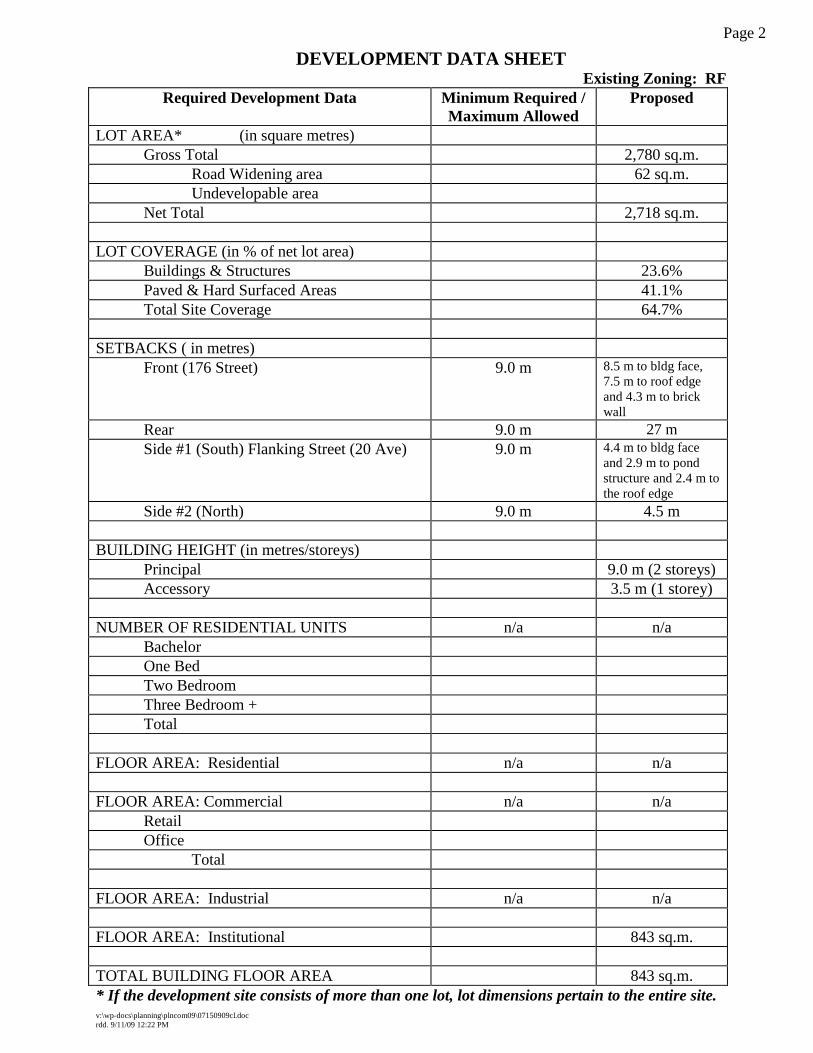
DEVELOPMENT DATA SHEET
Existing Zoning: RF
Required Development Data Minimum Required /
Maximum Allowed
Proposed
LOT AREA* (in square metres)
Gross Total 2,780 sq.m.
Road Widening area 62 sq.m.
Undevelopable area
Net Total 2,718 sq.m.
LOT COVERAGE (in % of net lot area)
Buildings & Structures 23.6%
Paved & Hard Surfaced Areas 41.1%
Total Site Coverage 64.7%
SETBACKS ( in metres)
Front (176 Street) 9.0 m 8.5 m to bldg face,
7.5 m to roof edge
and 4.3 m to brick
wall
Rear 9.0 m 27 m
Side #1 (South) Flanking Street (20 Ave) 9.0 m 4.4 m to bldg face
and 2.9 m to pond
structure and 2.4 m to
the roof edge
Side #2 (North) 9.0 m 4.5 m
BUILDING HEIGHT (in metres/storeys)
Principal 9.0 m (2 storeys)
Accessory 3.5 m (1 storey)
NUMBER OF RESIDENTIAL UNITS n/a n/a
Bachelor
One Bed
Two Bedroom
Three Bedroom +
Total
FLOOR AREA: Residential n/a n/a
FLOOR AREA: Commercial n/a n/a
Retail
Office
Total
FLOOR AREA: Industrial n/a n/a
FLOOR AREA: Institutional 843 sq.m.
TOTAL BUILDING FLOOR AREA 843 sq.m.
* If the development site consists of more than one lot, lot dimensions pertain to the entire site.

Page 3
v:\wp-docs\planning\plncom09\07150909cl.doc
rdd. 9/11/09 12:22 PM
Development Data Sheet cont'd
Required Development Data Minimum Required /
Maximum Allowed
Proposed
DENSITY
# of units/ha /# units/acre (gross)
# of units/ha /# units/acre (net)
FAR (gross)
FAR (net)
AMENITY SPACE (area in square metres)
Indoor n/a n/a
Outdoor n/a n/a
PARKING (number of stalls)
Commercial
Industrial
Residential Bachelor + 1 Bedroom
2-Bed
3-Bed
Residential Visitors n/a n/a
Institutional
Total Number of Parking Spaces n/a 11
Number of disabled stalls n/a 1
Number of small cars n/a n/a
Tandem Parking Spaces: Number / % of
Total Number of Units
n/a n/a
Size of Tandem Parking Spaces
width/length
n/a n/a
Heritage Site NO Tree Survey/Assessment Provided YES
Recommended