CHAPTER 3MAPS AND MAP CHANGES

Flood Maps: It’s Your Job to Flood Maps: It’s Your Job to Understand ThemUnderstand ThemFlood Maps: It’s Your Job to Flood Maps: It’s Your Job to Understand ThemUnderstand Them
• Read and understand the FIRM, and;• Interpret the Flood Insurance Study.

Riverine FloodplainsRiverine FloodplainsRiverine FloodplainsRiverine Floodplains
• Floodway: the channel of a river or other watercourse and the adjacent land areas that must be reserved in order to discharge the base flood without cumulatively increasing the water surface elevation more than one foot.
Definitions………

Riverine FloodplainsRiverine FloodplainsRiverine FloodplainsRiverine Floodplains
• Floodway fringe: that area of the floodplain on either side of the regulatory floodway where encroachment may be permitted without additional hydraulic and/or hydrologic analysis.
Definitions………

Riverine FloodplainsRiverine Floodplains

Floodway SchematicFloodway Schematic
100 YEAR FLOODPLAIN
SURCHARGE
FLOODWAYFRINGE
FLOODWAY + FLOODWAY FRINGE = 100 YEAR FLOODPLAIN SURCHARGE NOT TO EXCEED 1.0 FOOT
FLOODWAY
In the floodway - Before a local floodplain permit can be issued, a “no rise’ certification form must be submitted. You may need a qualified engineer to make sure your proposed project won’t increase flooding on other properties.

Coastal FloodplainsCoastal FloodplainsCoastal FloodplainsCoastal Floodplains
• Coastal High Hazard Area: an area of special flood hazard extending from offshore to the inland limit of a primary frontal dune along an open coast and any other area subject to high velocity wave action from storms or seismic sources. The area is designated on the FIRM as Zone V1 – V30, or VE or V.
Definitions………

Coastal FloodplainsCoastal FloodplainsCoastal FloodplainsCoastal Floodplains
• Coastal A Zone: the portion of the SFHA landward of a V zone…which may be subject to wave effects, velocity flows, erosion, scour, or combinations of these forces and are treated as V zones.
Definitions………

Coastal Floodplain

TYPES OF NFIP MAPSTYPES OF NFIP MAPSTYPES OF NFIP MAPSTYPES OF NFIP MAPS

How Do They Make Those How Do They Make Those EXCELLENT Floodplain Maps?EXCELLENT Floodplain Maps?

Components of Flood MapsComponents of Flood MapsComponents of Flood MapsComponents of Flood Maps
Title box
Community name
Panel number
Community number
Panel suffix
Effective/revision date
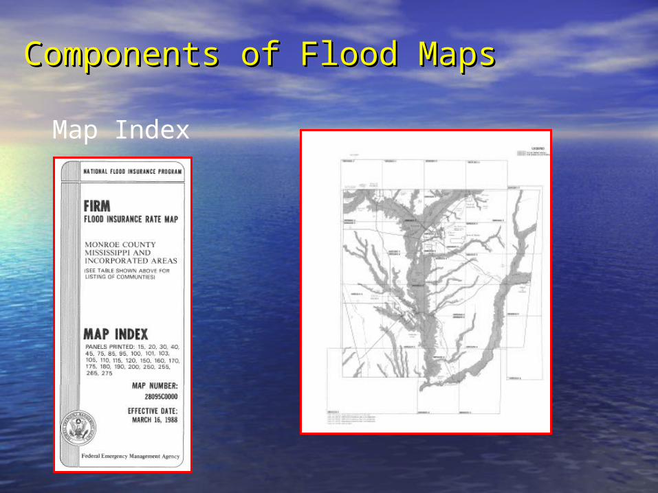
Components of Flood MapsComponents of Flood MapsComponents of Flood MapsComponents of Flood Maps
Map Index

Approximate Floodplain Map
(Flood Hazard Boundary Map)
Shows approximate location of flood risk.
Detailed information (ground elevation and flood height) are required to make accurate determinations

Flood Insurance Rate Map (FIRM)
Base Flood Elevation (BFE) Water Surface elevation (in feet) of the base flood at specific locations
Elevation Reference Marks (RM) Points for which ground elevation data have been established and recorded on the FIRM
Flood Hazard Zones. Zone A, Zone A1–A30, and Zone AE – 100-year or base flood
Zone B - 500 – year flood. Zone C or X – All other areas

Components of Flood Maps Components of Flood Maps (cont.)(cont.)
Components of Flood Maps Components of Flood Maps (cont.)(cont.)
FIRM “Old Format”

Flood Insurance Rate Map
(old format)
Base Flood Elevations
Reference Marks
Zone A
Zone B
Zone C

Flood Boundary and Floodway Map
(old format)
Flood Boundary and Floodway Map
(old format)
Stream channel
Floodway
Floodway fringe
Approximate A Zone
Elevation reference mark
Cross section

Flood Insurance Rate Map(New Format)
Flood Insurance Rate Map(New Format)
Unshaded X Zone
Zone AE
Floodway
Floodway fringe
Cross section
Base flood elevation
Shaded X Zone
Zone boundary
Approximate A Zone

Coastal Floodplain Map
A#, AE, A, AO Zones
V#, VE Zones

Levels of Detail in Floodplain Levels of Detail in Floodplain DelineationsDelineations
Levels of Detail in Floodplain Levels of Detail in Floodplain DelineationsDelineations
• Detailed Coastal: Based on detailed engineering methods, near-shore bathymetry, and coastal storms.
Two levels of Studies………

Coastal Barrier Resource Act (CoBRA) of 1982Coastal Barrier Improvement Act of 1990
• Areas subject to certain flood coverage restrictions. The NFIP is prohibited from writing flood insurance policies on new or substantially improved buildings in these areas.
Coastal Floodplain Map

Coastal Barrier Zones

Special FIRM
Formats Lakes
Floodplain Maps

Floodplain MapsFloodplain Maps
Shallow flooding
AO -ponding
AH – sheet flow
ZONE AO(DEPTH 2’)

Digital Flood Insurance Rate Maps The Next Generation

The “FIRMette”
• Available onlineAvailable online• Scaled to use as regulatory mapScaled to use as regulatory map• PrintablePrintable• www.FEMA.govwww.FEMA.gov
– Click “Map Store”Click “Map Store”– Click “Map Search”Click “Map Search”– Type in address Type in address – Click “view” mapClick “view” map

Components of a Flood Insurance Study (FIS)

Components of a Flood Insurance Study (FIS)
• Appraises a community’s flood Appraises a community’s flood problemsproblems
• Establishes flood elevation profilesEstablishes flood elevation profiles
• Establishes insurance risk zonesEstablishes insurance risk zones
• Plots floodplain boundariesPlots floodplain boundaries
• Provides data to delineate floodways Provides data to delineate floodways in some communitiesin some communities
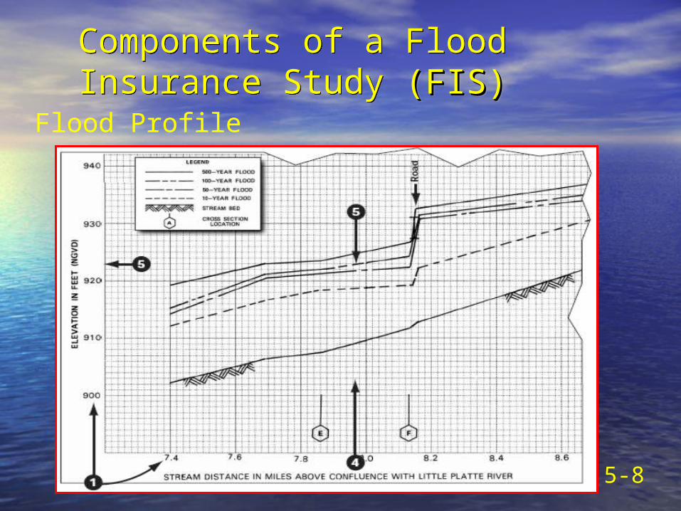
Components of a Flood Insurance Study (FIS) (FIS)
Components of a Flood Insurance Study (FIS) (FIS)
5-8
Flood Profile

Floodway Data Table
Components of a Flood Insurance Study (FIS)

Flood Insurance Studies (cont.)
Using the Floodway Data Table
Flood Insurance Studies (cont.)
Using the Floodway Data Table
1. Locate site on the FIRM or Floodway Map

Flood Insurance Studies (cont.)Using the Floodway Data Table
Flood Insurance Studies (cont.)Using the Floodway Data Table
If at a cross section, use the Floodway Data Table

Flood Insurance Studies (cont.)Using the Profile
Flood Insurance Studies (cont.)Using the Profile
If not at a cross section, use the profile

Flood Insurance Studies (cont.)Using the Profile
Flood Insurance Studies (cont.)Using the Profile
1. Locate site on the FIRM or Floodway Map
↕200 feetMcNeese Street
2. Measure the distance to a feature

Flood Insurance Studies (cont.)Using the Profile
Flood Insurance Studies (cont.)Using the Profile
3. Find the feature on the profile
4. Check the horizontal scale on the profile
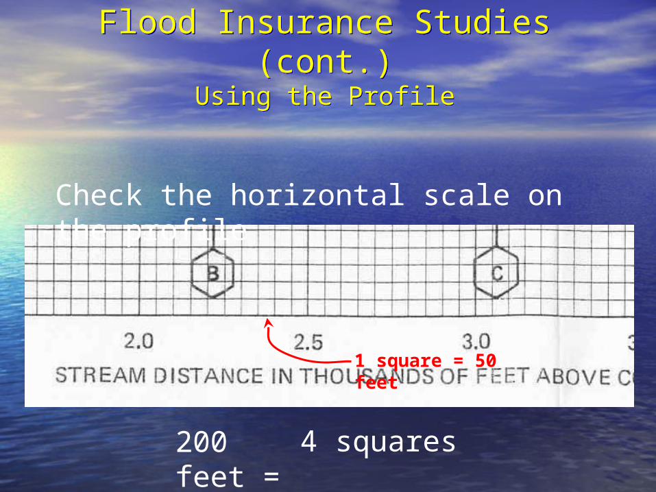
Flood Insurance Studies (cont.)Using the Profile
Flood Insurance Studies (cont.)Using the Profile
Check the horizontal scale on the profile
1 square = 50 feet
200 feet = 4 squares

Flood Insurance Studies (cont.)Using the Profile
Flood Insurance Studies (cont.)Using the Profile
4. Measure the distance to the site
5. Find the 100-year flood line and read the elevation on the left edge.
200 feet(4 squares)
↔
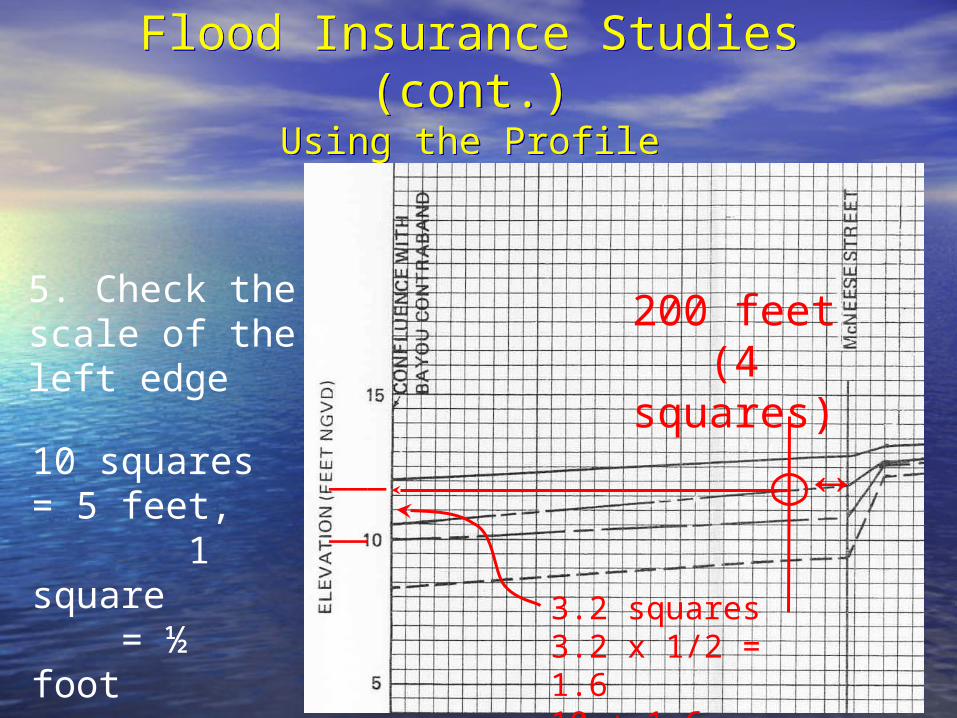
Flood Insurance Studies (cont.)Using the Profile
Flood Insurance Studies (cont.)Using the Profile
5. Check the scale of the left edge
200 feet(4 squares)
↔10 squares = 5 feet, 1 square = ½ foot 3.2 squares
3.2 x 1/2 = 1.610 + 1.6 = 11.6
___
__

Flood Insurance Studies (cont.)Using the Profile
Flood Insurance Studies (cont.)Using the Profile
Double check that the elevation, does it makes sense?

Map Changes
Sometimes the maps are just plain wrong!
Sometimes the floodplains are modified.
There is a process to correct them

Effect of Map Revisions
Map revisions can change SFHA boundaries and Base Flood Elevations in a community.

Letter of Map Amendment
(LOMA)
A letter from FEMA stating that an existing structure A letter from FEMA stating that an existing structure or parcel of land that has or parcel of land that has notnot been elevated by fill been elevated by fill would not be inundated by the 1% chance flood.would not be inundated by the 1% chance flood.
(Fill is defined as material placed to raise the (Fill is defined as material placed to raise the ground to or above the BFE.)ground to or above the BFE.)

Letter of Map Amendment (LOMA)
House is shown in the floodplain
But NATURAL ground elevations prove it to be higher than the flood elevation

Letter of Map Amendment (LOMA)
Situation:
Structure is located on NATURALLY high ground
Information needed by FEMA:
Completed MT-1 Form 1 (or MT-EZ)
Cost: “free”Cost: “free”

*Used for inadvertent inclusions only.
*Natural ground is higher than the flood elevation.
MT-EZ

Conditional Letter of Map Amendment (CLOMA)
A letter from FEMA stating that a proposed structure that is not to be elevated by fill would not be inundated by the 1% chance flood if built as proposed.

Letter of Map Revision (LOMR)
Floodplain as shown on the floodplain map
New floodplain based on PHYSICAL modification
FillNew stream location

Letter of Map Revision (LOMR)
Situation:
Physical changes to the floodplain, the floodway, or flood elevations.
Information needed by FEMA:
Detailed engineering and MT-2 Form
Cost: not cheap

Map Change ProcessesMap Change Processes
• Fees are charged for proposals to change the FIRM by grading or filling.
• www.fema.gov/fhm.frm_fees.shtm
5-17

Conditional Letter of Map Revision (Based on Fill)
CLOMR-F
A letter from FEMA stating that a parcel of A letter from FEMA stating that a parcel of land or proposed structure that is to be land or proposed structure that is to be elevated fill would not be inundated by the elevated fill would not be inundated by the 1% chance flood if fill is placed on the parcel 1% chance flood if fill is placed on the parcel as proposed and the structure is built as as proposed and the structure is built as proposed.proposed.

LOMR-FLOMR-F

Technical Bulletin 10-01Technical Bulletin 10-01

LOMR-F? LOMR-F? With a basement below With a basement below
BFE??BFE??NOT in the Gulf States! NOT in the Gulf States!
NOT while I’ve got a sayNOT while I’ve got a say!!

LOMA/R
TOLL-FREE HOTLINE
1-877-FEMA MAP (366-2627)
Inundated with calls about changing the maps from residents, insurance companies, or appraisers, etc?
Need to know the status of a current LOMA/R request?

Effect of Map Revisions
• You must retain all versions of your FIRMs.• It is a good idea to file a ‘FIRMette’ with every
permit.

Effect of Map Revisions (cont.)
• LOMAs and LOMRs could be invalidated by a map revision.
• Contact your State NFIP Coordinator for the procedures to pass on to the affected citizens.

Effect of Map Revisions (cont.)
• SFHA increases…new areas are subject to your ordinance.
• Buildings in new SFHA are now subject to the mandatory purchase of flood insurance.

Letter of Determination ReviewLetter of Determination ReviewLetter of Determination ReviewLetter of Determination Review
• When a borrower and lender disagree on a floodplain determination during the loan process, FEMA can review the determination.
• FEMA has 45-days to respond, and, by law, FEMA’s determination is final.

My lending institution said I’m in the floodplain and they require flood insurance on my loan/mortgage. I don’t believe I’m in a flood zone. What can I do?
All federally regulated lending institutions must review the community Flood Insurance Rate Map (FIRM) to determine if your structure is located in a Special Flood Hazard Area (SFHA). If such a determination is made, it must require the borrower to purchase flood insurance. These determinations are based on in/out (horizontal) and do not involve the vertical elevation of the structure.
If you disagree, you may request that FEMA review the lender’s determination. FEMA will review the information that the institution used and issue a letter of findings. Your request (FEMA Standard Flood Hazard Determination) must be postmarked no later than 45 days after the lender notifies you of its determination. FEMA’s responses to these requests are called LODRs and offer two basic dispositions: (1) the lender’s determination stands or (2) it is overturned. FEMA’s response does not amend or revise the NFIP map for your community.
Occasionally, a lending institution may require insurance if it determines that a part of your lot is in the SFHA. The NFIP does not insure land. However, even if you submit evidence that your building is out of the floodplain, the lender may still decide to require flood insurance on your building.

Letter of Determination Review Letter of Determination Review (cont.)(cont.)Letter of Determination Review Letter of Determination Review (cont.)(cont.)
5-19

Flood Map ModernizationFlood Map Modernization
• FEMA 5-year, $1 billion national programFEMA 5-year, $1 billion national program
• FEMA sets the schedule and the funding FEMA sets the schedule and the funding --annually updated in the Multi-Year Flood --annually updated in the Multi-Year Flood Hazard Identification PlanHazard Identification Plan

Age of Flood MapsAge of Flood Maps
22%
8%
10%
60%
< 5 years old 5-10 years old
10-15 years old > 15 years old
As of 2002

Map Mod ObjectivesMap Mod Objectives
More accurate floodplain managementMore accurate floodplain management Up-to-date, standardized digital flood Up-to-date, standardized digital flood
maps throughout the country maps throughout the country ArcGIS geo-database format ArcGIS geo-database format Seamless, nationwide flood layerSeamless, nationwide flood layer Internet-accessible through FEMA's Internet-accessible through FEMA's
Multihazard Information Platform (MIP) Multihazard Information Platform (MIP)

Advantages of DFIRMsAdvantages of DFIRMs
Map revisions will be faster and easier – Map revisions will be faster and easier – months instead of yearsmonths instead of years
Communities will be able to use the digital Communities will be able to use the digital flood map data with their local data, such flood map data with their local data, such as parcel dataas parcel data
The new flood risk maps will cover entire The new flood risk maps will cover entire counties counties
If a community is located in more than one If a community is located in more than one county, it will be mapped only to the county, it will be mapped only to the county bordercounty border

Local ParticipationLocal Participation
• Share base map dataShare base map data
• Review current maps for errors Review current maps for errors
• Provide information on new studies or Provide information on new studies or floodplain changes that may affect BFEsfloodplain changes that may affect BFEs
• Document future mapping needsDocument future mapping needs
• Review preliminary mapsReview preliminary maps
• Collect and submit appeals & protestsCollect and submit appeals & protests
• Adopt final maps and update local Adopt final maps and update local floodplain ordinancefloodplain ordinance

Mapping ProcessMapping ProcessConvert FIRMConvert FIRM
• Register Register (align) (align) existing FIRMexisting FIRM to the community base map to the community base map
• Digitize flood data (floodplain Digitize flood data (floodplain boundaries, cross sections, boundaries, cross sections, BFEs, etc.)BFEs, etc.)
• Convert to NAVD 1988 Convert to NAVD 1988 vertical datumvertical datum
• Incorporate LOMCsIncorporate LOMCs

Mapping ProcessMapping ProcessCorrect and UpdateCorrect and Update
• Validate cross section locations Validate cross section locations using FIS profile data using FIS profile data
• Align floodplains with stream Align floodplains with stream locations on base map (Zone A)locations on base map (Zone A)
• Correct and update municipal Correct and update municipal boundaries and road, stream boundaries and road, stream and lake namesand lake names

ExampleExample
Redelineated SFHA
Original FIRM SFHA
Cross section
Base flood elevation
LIDAR-contour lines
Redelineation

• Part of the scoping process is to identify the Part of the scoping process is to identify the mapping needs of a countymapping needs of a countyAreas where flood risk needs to be Areas where flood risk needs to be
identified (never studied) identified (never studied) Areas where flood risk needs to be Areas where flood risk needs to be
refined because of changes in hydrology refined because of changes in hydrology or hydraulics—new bridges, culverts, etc.or hydraulics—new bridges, culverts, etc.
Any other community mapping issueAny other community mapping issue
• These will be prioritized for future flood These will be prioritized for future flood studiesstudies
What About Areas What About Areas That Need Study?That Need Study?

• Review current maps and noteReview current maps and noteCorrectionsCorrectionsChanges that could affect BFEs on Changes that could affect BFEs on
studied streamsstudied streamsNew flood studiesNew flood studiesMapping needsMapping needs
• Identify and complete any study Identify and complete any study needs.needs.
• Have base maps ready for use.Have base maps ready for use.
To Do NowTo Do Now

Mississippi Flood Map Modernization Mississippi Flood Map Modernization InitiativeInitiativeMississippi Flood Map Modernization Mississippi Flood Map Modernization InitiativeInitiative

Mississippi Flood Map Modernization Mississippi Flood Map Modernization InitiativeInitiative
Mississippi Flood Map Modernization Mississippi Flood Map Modernization InitiativeInitiative

Insert LA Map Mod SlidesInsert LA Map Mod Slides

Using Maps and DataUsing Maps and Data
Site #1. House
1. In the SFHA?
2. In the floodway?
3. What’s the BFE?
#1 ↓ ▀

Using Maps and DataUsing Maps and Data
Site #2. Store
1. In the SFHA?
2. In the floodway?
3. What’s the BFE? #2 ↓ ▀

Using Maps and DataUsing Maps and Data

Using Maps and DataUsing Maps and Data
Site #3. House
1. In the SFHA?
2. In the floodway?
3. What’s the BFE?
#3 ↓ ▀

Using Maps and DataUsing Maps and Data
Site #4. Shopping center (7 acres)
1. In the SFHA?
2. In the floodway?
3. What’s the BFE?
#4 ↓
▀

Using Maps and DataUsing Maps and Data
Site #5. House
1. In the SFHA?
2. In the floodway?
3. What’s the BFE?
#5 ↓ ▀

Using Maps and DataUsing Maps and Data
Unincorporated areasUnincorporated areas

Using Maps and DataUsing Maps and Data
New flood studiesNew flood studies
Managing Floodplain Development Managing Floodplain Development in Approximate Zone A Areasin Approximate Zone A Areas
Recommended