C I T Y O F C A M B R I D G E
COMMUNITY DEVELOPMENT DEPARTMENT
IRAM FAROOQ
Assistant City Manager for Community Development
344 Broadway
Cambridge, MA 02139
Voice: 617 349-4600
Fax: 617 349-4669
TTY: 617 349-4621
www.cambridgema.gov
To: Planning Board
From: Jeff Roberts, Land Use and Zoning Planner
Date: August 9, 2016
Re: Medical Marijuana District (MMD) Zoning Petitions
Overview
There are currently two zoning petitions before the City Council to amend the Medical
Marijuana Overlay Districts (MMDs) in the Cambridge Zoning Ordinance. Both are
petitions by groups of Cambridge residents, but are organized by Registered Marijuana
Dispensary (RMD) operators who are seeking approval through the Massachusetts
Department of Public Health (MDPH) medical marijuana program.
The first petition is by Healthy Pharms, Inc., proposing to create a new MMD‐4 in
Harvard Square in areas zoned Business B (BB) and Office 3 (O‐3). This petition will be
heard by the Planning Board on August 16. The second petition is by the William Noyes
Webster Foundation, Inc., to expand the current MMD‐1 to include areas zoned Industry
B‐2 (IB‐2) west of Smith Place. This petition will have a future hearing.
During the recent discussion of the Sage Cannabis, Inc. Zoning Petition, questions were
raised about whether Cambridge’s medical marijuana zoning should be reassessed in a
more comprehensive way. Although the two petitions under consideration will be heard
separately, it seemed beneficial to review them within this broader context of medical
marijuana zoning citywide. The first part of this report focuses on medical marijuana
zoning and regulations in general, rather than the specific proposals. Then, comments
on each individual proposal are provided at the end.
Background
In 2013, Cambridge adopted zoning regulations for RMDs following the promulgation of
statewide medical marijuana regulations. These regulations allow RMDs to be
established only within the designated MMDs, and only after the granting of a special
permit by the Planning Board. Since 2013, no proposals have been made within the
original MMDs, but there have been proposals to expand or enlarge the MMDs. The
Sage Cannabis, Inc. petition is the only such proposal to be adopted thus far
(establishing the MMD‐3 District in 2016), and Sage Cannabis is also the only RMD to
apply for and receive a special permit from the Planning Board.
An RMD cannot be established in Cambridge unless it has been approved at the state
level by the MDPH. The state approval process is discussed on the following page, and
more information is available at www.mass.gov/medicalmarijuana.
Medical Marijuana District (MMD) Zoning Petitions – Memo to Planning Board
August 9, 2016 Page 2 of 8
Statewide RMD Registration Process
Since the MDPH regulations were first promulgated in 2013, there have been substantial changes to the
way they are administered at the state level. Originally, there was a competitive selection process by
which prospective RMD operators would apply, and a selection committee would score applications
based on a set of evaluation criteria, one of which was geographic distribution of RMDs across the state.
The 2012 law authorizing medical marijuana in Massachusetts sets a limit of no more than 35 RMDs
across the state, and no more than 5 per county, but allows the MDPH to raise that limit on finding that
“the number of treatment centers is insufficient to meet patient needs.” In practice, the competitive
selection process resulted in very few RMDs being approved, despite over 100 initial applicants.
In 2015, the MDPH changed to a non‐competitive approval process, through which it receives
applications on a rolling basis and evaluates them individually for compliance with standards for
operation, security, inspection and organizational solvency, among other standards. Instead of applying
geographic distribution as a selection factor, MDPH relies on each applicant to receive a letter of
support or non‐opposition from a local host community. Therefore, municipalities have a greater say in
determining whether, and how many, RMDs may be allowed in their communities.
Cambridge’s MMD zoning was created on the assumption that only one, if any, RMD would be allowed
within the city given the statewide competitive selection process. As a result, the zoning only allowed
RMDs within specific locations with the best access to regional roadways and transit. The MDPH’s
procedural changes have led to multiple RMD operators expressing an interest in locating in Cambridge.
Therefore, aside from where to establish zoning districts, the following broader questions should now
be considered:
How many RMDs should be allowed in Cambridge?
If there are multiple RMDs in Cambridge, should they be concentrated in one or more areas,
or distributed throughout the city?
Given the broad interest among RMDs, should a local selection process be considered?
Some of these questions could be addressed through the Zoning Ordinance. For example, zoning could
establish a citywide “cap” on RMDs, or could establish limits on the number of RMDs allowed within any
particular geographic area. Zoning issues are discussed in more detail on the following pages.
However, there are also non‐zoning approaches that could be considered. Because applicants are
required to seek a letter of support or non‐opposition from host communities, many municipalities have
negotiated “host community agreements” as a part of their process for deciding whether to support an
RMD application. This process would allow the city to engage more directly with RMD operators and
consider factors specific to that operator, rather than just the land use factors that are regulated
through zoning.
Some aspects of RMD operation can also be regulated through the Cambridge Public Health
Department, which is currently considering a draft set of regulations.

Medical Marijuana District (MMD) Zoning Petitions – Memo to Planning Board
August 9, 2016 Page 3 of 8
Medical Marijuana Zoning in Cambridge
The zoning regulations for medical marijuana in Cambridge, set forth in Section 20.700 of the Zoning
Ordinance, create a system by which RMDs are allowed by special permit from the Planning Board
within specific designated Medical Marijuana Overlay Districts (MMDs).
In considering a special permit application, the Planning Board reviews the particulars of the proposal in
order to assess site‐specific impacts and require mitigation where appropriate. The special permit
review addresses land use considerations including the expected service area for the proposed RMD,
transportation and parking needs, loading and service activity, and conformance with urban design
objectives. The review also considers whether the proposed site is at least 500 feet from schools and
other facilities with programs for children, though the Planning Board may reduce the standard 500‐foot
distance in particular cases if such facilities are found to be adequately shielded from the operation of
the proposed RMD.
MMD Locations
When considering what areas should be designated as MMDs when the zoning was crafted in 2013, the
following factors were considered:
1. Allowed Uses: RMDs would only be allowed in districts that otherwise allow commercial uses.
2. Transportation: Areas with access to regional roadways and public transportation would be
preferred.
3. Public Safety: Areas that are isolated and difficult to reach for emergency vehicles would be
excluded.
4. Urban Character: State‐imposed security regulations would require an RMD to be inaccessible,
physically and visually, to the general public. This could be disruptive in areas with an active
streetscape character, such as squares and retail corridors.
5. Buffers from Sensitive Uses: While the special permit review process considers whether a proposed
RMD is buffered from schools or other facilities that have programming directed toward children,
areas with a large concentration of such facilities were excluded from consideration as MMDs.
Factors 1 and 3 above remain relevant and probably do not require reassessment. However, the
remaining factors may be reassessed in the following ways:
Transportation: The current MDPH selection process removes strict limits on the number of RMDs
statewide and provides municipalities a greater role in determining the level of RMD service for
their own communities, which implies that RMDs may be located to serve a more local rather than
regional patient population. Therefore, it may not be as important to restrict RMDs to major
regional roadways. Nevertheless, given that patients from surrounding communities will still be able
to access any RMD, areas that are centrally located with good transit service and pedestrian and
bicycle access are still preferable.
Medical Marijuana District (MMD) Zoning Petitions – Memo to Planning Board
August 9, 2016 Page 4 of 8
Urban Character: Statewide security regulations require RMDs to be shielded from public view, and
require strict monitoring of access and egress to ensure that only registered patients and employees
may enter the facility. The potential disruption that these security measures may have on active,
pedestrian‐oriented retail corridors remains a concern. However, this concern could be mitigated in
other ways, as evidenced by the Sage Cannabis petition, which limits RMDs to the basement or
upper levels, retaining the ground floor for more active, publicly oriented retail. The Healthy Pharms
proposal similarly suggests setting RMDs back from the street, with only limited frontage allowed for
entry and exit of the RMD. The Sage Cannabis, Inc. petition also introduced the notion of limiting
RMDs to dispensing operations only, not cultivating or processing facilities, so that they would be
more compatible with retail and office districts.
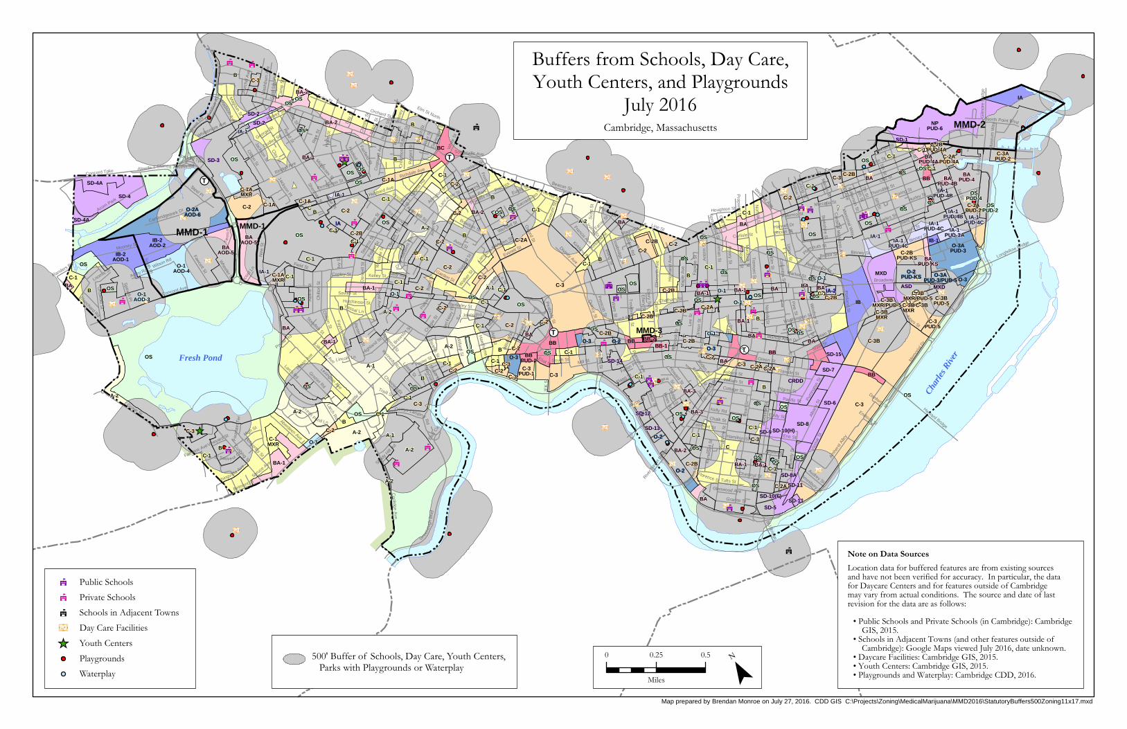
Buffers from Sensitive Uses: The attached map, which is an updated version of a map first prepared
in 2013, shows zoning districts and transportation facilities along with a depiction of 500‐foot
buffers from schools, day care facilities, youth centers and playgrounds. Taken together, this map
indicates where there are commercial‐use districts (those areas colored in red, pink, purple and
blue) that contain the most available area outside of the 500‐foot buffers. State regulations also
allow communities to set their own buffers, and so Cambridge could consider reducing the 500‐foot
buffer to some other distance, though it is difficult to determine what an acceptable distance might
be for every case. Still, there are many commercial areas that are outside of the 500‐foot buffers.
If the factors for assessing potential MMD locations were revisited in the ways described above, the
following other commercial districts might be reevaluated for their appropriateness as potential MMDs:
Major Squares (Porter, Harvard, Central, Kendall)
These are predominantly commercial districts with superior access to public transit, and are in
highly accessible areas for pedestrians and bicyclists. However, the planning for these areas
encourages strong, publicly oriented ground floor retail, and therefore the impact of RMDs as a
closed, non‐public use would need to be mitigated. Potential approaches might include limiting the
ground‐floor street frontage of an RMD, encouraging the facility to be located above or below
grade, or requiring it to be located behind an active retail frontage. The proximity of child‐oriented
facilities may also be a concern; Central Square in particular has nearby schools and youth centers,
and other squares often have child care uses co‐located with office or university functions.
Other Massachusetts Avenue Commercial Areas
The BB‐2/MMD‐3 district is an example of a higher‐intensity mixed‐use district along Massachusetts
Avenue that has been deemed to be appropriate for an RMD. Other areas might be evaluated in a
similar way, such as the nearby BB‐1 district, or the section of Massachusetts Avenue south of
Central Square. These parts of Massachusetts Avenue are predominantly commercial in character
and have reasonably good access to transportation. However, they also have strong institutional
presences, and the impacts on ground‐floor retail character would still need to be considered.
Transitioning Industrial Areas
Cambridge has a few areas that are historically industrial, but have been transitioning to other uses
in recent years. One such area is the former industrial land stretching from about the BU Bridge to
Medical Marijuana District (MMD) Zoning Petitions – Memo to Planning Board
August 9, 2016 Page 5 of 8
Kendall Square, north of the Grand Junction rail line. While this area remains predominantly
commercial, some parts have transitioned to residential and institutional uses. A similar area is the
“Quadrangle” north of Concord Avenue along Fresh Pond, some of which is already in the MMD‐1
district (which is proposed to be expanded by the William Noyes Webster Foundation, Inc., petition).
Although an RMD in either of these areas would have less impact on residential uses or urban
character than in many other parts of the city, much thought will need to be given to how an RMD
would fit into the future plans for these areas as they take on an increasingly mixed‐use character
with growing residential populations. Additionally, these areas tend not to be as well served by
transit, though each has planned pedestrian and bicycle improvements (such as the Grand Junction
multi‐use pathway and the Alewife pedestrian/bicycle railroad crossing).
Neighborhood Retail Districts
Areas such as Inman Square, northern Massachusetts Avenue, and sections of Concord Avenue,
Huron Avenue and Mount Auburn Street (shown in pink on the map) allow commercial uses, but the
surrounding character is more residential and the commercial uses tend to be neighborhood‐
oriented retail and services. While there may be some sites where it is possible to locate an RMD,
there is greater potential in these areas for an RMD to displace or disrupt other neighborhood‐
serving retail uses. In addition, these areas are generally not as well served by transit and not as
centrally located to serve a broad client base.
In addition to considering additional MMD areas, an option would be to adopt an approach of allowing
or prohibiting RMDs directly within the base zoning regulations. While this might be a simpler approach,
the results would be more difficult to predict, and it would be more difficult to establish unique
regulations for specific districts (such as a “cap” on the number of RMDs allowed in a particular area, if
desired).
Comments on Zoning Petitions
The maps on Pages 7‐8 depict the current MMDs in Cambridge and the proposed expansions of those
districts. It should be noted that both petitions are by prospective RMD operators who have particular
dispensing sites in mind; however, the proposed zoning changes would allow any potential RMD
operator to seek a special permit for an RMD within that district.
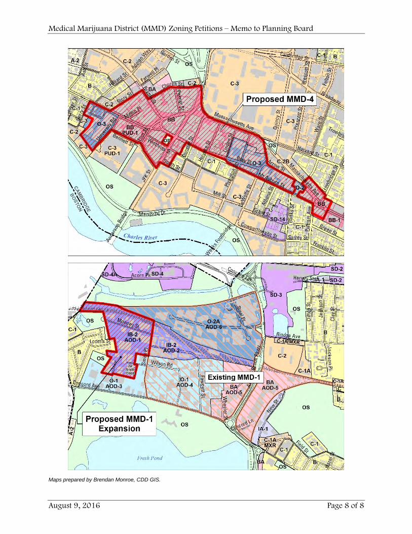
Healthy Pharms, Inc. – MMD‐4 in Harvard Square
The proposal by Healthy Pharms, Inc., is to designate a new MMD within Harvard Square, specifically in
areas that are within the Harvard Square Overlay District and also within the base zoning districts
Business B (BB) and Office 3 (O‐3), which include the higher‐density areas in the heart of the square. The
petition would also establish criteria particular to a Registered Marijuana Dispensary (RMD) in the
MMD‐4 district, including a use limitation to retail dispensing only, a maximum floor area of 10,000
square feet, a required 15‐foot setback from sidewalks, and a reduction of the required buffer from
schools, playgrounds and similar uses from 500 to 250 feet.
Medical Marijuana District (MMD) Zoning Petitions – Memo to Planning Board
August 9, 2016 Page 6 of 8
The “Major Squares” discussion in the prior section summarizes issues relevant to this proposal. Harvard
Square is one of the most centrally located commercial areas in the city, readily accessible by walking
and bicycling as well as subway and bus service. It is also along regional road networks (though traffic
may be a concern), and public parking is available but limited. There is a strong ground‐floor retail
presence throughout Harvard Square, but also many opportunities to locate RMDs in places that do not
occupy ground floor frontage, such as basements, upper floors, and the interiors of blocks.
There are a few particular issues raised by this proposal that are important to consider:
Given the prominence of Harvard Square as a regional destination, there may be a higher likelihood
that more than one RMD would seek to locate within the district. Without a statewide selection
process to control the number of RMDs, it might be difficult for the Planning Board to assess
whether or not a proposal would be providing needed service to the area if other RMDs are already
approved or operating. At one extreme, Harvard Square could become home to a “cluster” of RMDs
that might saturate the market or otherwise affect the character of the area. The Planning Board
and City Council should consider whether this would be desirable or acceptable, and if not, might
consider controls, such as a cap on the number of RMDs allowed within the district, or some other
standard.
The petition proposes a required 15‐foot setback from the sidewalk for an RMD, which seems
intended to address the concern about interrupting the character of retail ground floors. However,
the proposal may not be adequate, because the distance from the street is not the issue so much as
the amount of ground‐floor frontage occupied by the RMD. The Board might consider an alternative
standard that limits the ground‐floor frontage of an RMD to some amount that is necessary for
access and egress – perhaps 10 or 20 feet – and requires the rest of the facility to be either below
grade, above the first floor, or behind a minimum depth of retail frontage. Such standards could also
be subject to Planning Board modification during the special permit approval process.
The petition proposes reducing the required buffer from facilities with programming for children
from 500 to 250 feet. The map prepared by CDD shows that most of the district is outside the 500‐
foot buffers, although it is possible that this map does not include every use that may possibly fall
under the MDPH definition for such a facility. The petitioners’ rationale for why 250 feet is a more
appropriate buffer distance than 500 feet should be more fully explained.
Expansion of MMD‐1 in Alewife
The proposal by the William Noyes Webster Foundation, Inc., is to expand the current MMD‐1 district,
which currently has Smith Place as its western boundary, to include the additional district west of Smith
Place that is zoned Industry B‐2 (IB‐2) and Alewife Overlay District 1 (AOD‐1). No other change to the
approval criteria are proposed in that district, and therefore any type or size of RMD could be allowed
subject to Planning Board review and approval.
The “Transitioning Industrial Areas” discussion in the prior section summarizes issues relevant to this
proposal. While the proposed area of expansion has many characteristics that are similar to the current
MMD‐1 district, there are a few particular issues worthy of consideration:
Medical Marijuana District (MMD) Zoning Petitions – Memo to Planning Board
August 9, 2016 Page 7 of 8
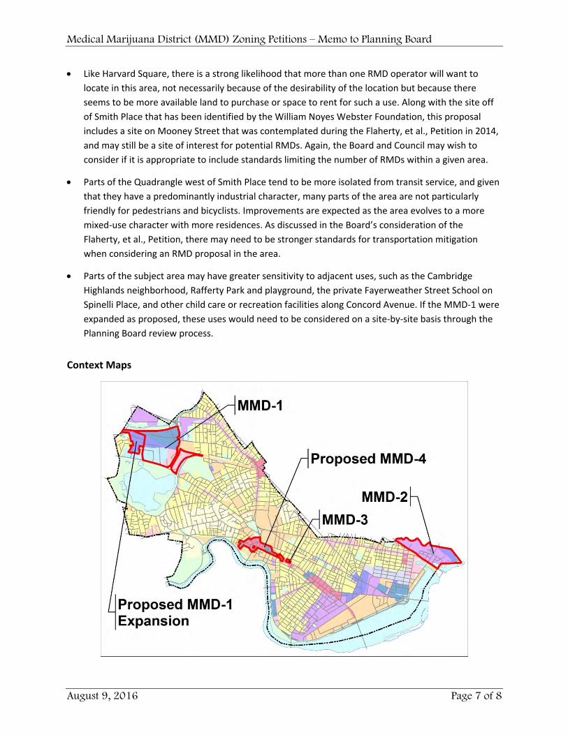
Like Harvard Square, there is a strong likelihood that more than one RMD operator will want to
locate in this area, not necessarily because of the desirability of the location but because there
seems to be more available land to purchase or space to rent for such a use. Along with the site off
of Smith Place that has been identified by the William Noyes Webster Foundation, this proposal
includes a site on Mooney Street that was contemplated during the Flaherty, et al., Petition in 2014,
and may still be a site of interest for potential RMDs. Again, the Board and Council may wish to
consider if it is appropriate to include standards limiting the number of RMDs within a given area.
Parts of the Quadrangle west of Smith Place tend to be more isolated from transit service, and given
that they have a predominantly industrial character, many parts of the area are not particularly
friendly for pedestrians and bicyclists. Improvements are expected as the area evolves to a more
mixed‐use character with more residences. As discussed in the Board’s consideration of the
Flaherty, et al., Petition, there may need to be stronger standards for transportation mitigation
when considering an RMD proposal in the area.
Parts of the subject area may have greater sensitivity to adjacent uses, such as the Cambridge
Highlands neighborhood, Rafferty Park and playground, the private Fayerweather Street School on
Spinelli Place, and other child care or recreation facilities along Concord Avenue. If the MMD‐1 were
expanded as proposed, these uses would need to be considered on a site‐by‐site basis through the
Planning Board review process.
Context Maps
Medical Marijuana District (MMD) Zoning Petitions – Memo to Planning Board
August 9, 2016 Page 8 of 8
Maps prepared by Brendan Monroe, CDD GIS.
!!!!
!!!
!!
!!!
!!
!!!
!!!!!
!!!
!!!!!
!!!
!!
!
!
! ! !!
!
!
!!!
!!
_̂
_̂
_̂
_̂
_̂ _̂
¥]£
¥]£
¥]£¥]£
¥]£
¥]£
¥]£
¥]£
¥]£
¥]£
¥]£
¥]£
¥]£
¥]£
¥]£
¥]£
¥]£
¥]£
¥]£
¥]£
¥]£
¥]£
¥]£
¥]£
¥]£
¥]£
¥]£
¥]£
¥]£
¥]£
¥]£
¥]£
¥]£
¥]£
¥]£
¥]£
¥]£
¥]£
¥]£
¥]£
¥]£
¥]£
¥]£
¥]£
¥]£
¥]£
¥]£
¥]£
¥]£
¥]£
¥]£
¥]£
¥]£
¥]£
¥]£
¥]£
¥]£¥]£
¥]£
¥]£
¥]£
¥]£
¥]£
¥]£
¥]£
¥]£
¥]£
¥]£
¥]£
¥]£
¥]£
¥]£
!!T
!!T
!!T
!!T
!!T
!!T
k
kk
k
k
k
k
k
k
k
k
kk
k
k
k
k
k k
kk
k
k
k
k
k
k
k
k
k
k
k
k
k
k k
k
k
k
k
k
¥]£
¥]£
¥]£
¥]£
¥]£
¥]£
¥]£
Fresh Pond
Charle
s Rive
r
MMD-1MMD-1
MMD-2
MMD-3
NPPUD-6
IB-2AOD-1
IB-2AOD-2
BBPUD-1
BAPUD-4
BAAOD-5
BAAOD-5
BAPUD-4B
BAPUD-KS
BAPUD-4A
O-2AAOD-6
O-3APUD-3
O-2PUD-KS O-3A
PUD-3/PUD-5
IA-1PUD-4C IA-1
PUD-3A
IA-1PUD-4B
IA-1PUD-4C
IA-1PUD-4B
IA-1PUD-4C
O-1AOD-4
O-1AOD-3 C-3B
PUD-5
C-3APUD-2
C-2BPUD-KS
C-1AMXR
C-3APUD-2
C-3PUD-1
C-3PUD-5
C-3BMXR
C-2BPUD-4A
C-1AMXR
C-2APUD-4A
C-3BMXR/PUD-5C-3BMXR
C-3BMXR/PUD-5
C-1MXR
OS
OS
OS
OS
OS
OS
OS
OS
OS
OSOS
OS
OS
OS
OSOS
OSOS
OS
OS
OS
OS
OS
OS
OS
OS
OS
OS
OS
OS
OS
OS
OS
OS
OS
OS
OS
OS
OS
OS
OSOS
OS
OS
OS
OS
OS
OS
OS
OS
OS
OS
OS
OS
SD-8
SD-3
SD-4
CRDD
MXD
SD-6
SD-5
SD-4A
SD-7
ASD
SD-8A
SD-9
SD-1
SD-2
SD-10(H)
SD-15
SD-11
SD-2
SD-13
SD-4A
SD-14
SD-12
SD-10(F)SD-11
MXD
IB
IA
IA
IB-1
IA-2
IA-1
IA-1
IA-1
IA-1
BB
BC
BB
BB
BB-1BB
BB
BB-2
BA
BA
BA-2
BA-1
BA
BA-1 BA
BA-3
BA-2
BA
BA
BA-2
BA
BA
BA
BA-1
BA
BA
BA-1
BA-1
BA
BA-3
BA-1
BA-1
BA-2
BA-1
BA-1
BAO-1
O-1
O-1
O-1
O-1
O-1
C-3
C-3
C-3
C-3B
C-2
C-2C-2
C-2
C-2
C-3
C-2A
C-2
C-2B
C-2
C-2
C-3
C-2B
C-2B
C-2
C-1A
C-3
C-2B
C-2
C-2A
C-1A
C-2B
C-1A
C-3
C-2C-2
C-3
C-2
C-3C-2
C-2B
C-2
C-2
C-2BC-2
C-2B
C-2A
C-2B
C-3
C-2
C-2
C-2B
C-2AC-2AC-3
C-3B
C-1
B
B
CB
B
C-1
B
B
BC-1
B
C-1
B
B
C-1
B
B
B
C-1
B
C-1
C-1
C-1
C-1
C-1
B
C-1
B
C-1
C-1
C-1
C-1
C-1
C-1
C-1
C-1
C-1
C-1
C-1
B
C-1
C
C-1
C-1
C-1
C-1
C-1
C-1
O-3O-3
O-2
O-3
O-3
O-2
O-2
A-1
A-2
A-2A-2
A-2
A-2
A-2
A-2 A-1
A-1
A-2
A-2
OSPUD-4
OSPUD-2
Mem
oria
l Dr
Main St
Brattle
St
Concord Ave
Broadway
Huron
Ave
Harvard St
3rd St
Vas
sar
St
Garden St
Green St
Beacon St
Pea
rl S
t
1st St
Putnam
Ave
Windsor S
t
Wal
den
St
Franklin St
Riv
er S
t
Elm
St
Sid
ney
St
Alb
any
St
6th St
Oxford S
t
Co
lumbia S
t
Rindge Ave
Bro
okli n
e S
t
Gore St
Mag
azin
e S
t
Hampshire St
Inma
n St
Pr ospe
ct St
Rogers St
No
rfolk S
t
Sherman St
Erie St
Spring St
Allston St
Pleasa
ntS
t
Da
na St
Orchard St
Line St
Land
Blv
d
Charles St
Co
olidge A
ve
Sparks S
t
Elle ry S
t
Uplan
d R
d
Blanchard Rd
Kirkla
nd S
t
Hurley St
JFK
St
Bent St
Thorndike St
Tre
mon
t St
Lakeview Ave
Concord Tpke
Chestnut St
G
reen
ough
Blv
d
Vassal Ln
Grove St
Raymond St
Lee
St A
mes St
New
St
Fayerweather S
t
Dudley St
Clay S
t
Harvey St
Lexington Ave
Willow
St
Cedar S
t
Kinnaird St
Appleton St
Fawcett S
t
Jay St
7th St
Sm
ith Pl
Han
cock
St
Larch Rd
Ash
St
Cushing St
IrvingSt
Reed St
Wendell St
Quincy S
t
Amhe
rst A
lley
Fulkerson St
Port lan
d St
Acorn Park
Market St
Foster St
Clifton S
t
Field St
An
trim
St
Pemberton St
Holworthy St
Elm St North
Washington St
Pine S
t
Auburn St
Bishop Allen Dr
Pacific St
Belmont St
Am
or y S
t
Shep
ard
St
Ric
e S
t
Harvard Bridge
Francis Ave
Be
rkshire St
How
ard St
Cra
igie
St
Grozier Rd
Sacramento
St
Fay
ett e
St
8th St
Steel Pl
Un
ion St
Jackson St
Cherry S
t
Haskell S
t
Hamilton St
Wal
ker S
t
State St
Frost St
Forest St
Alp
ine
St
Sco
tt S
t
Reservoir S
t
Highland St
Cambridgepark Dr
Mill St
Rus
sell
St
Ma p
le A
ve
Avon St
Avon Hill St
North Point Blvd
Bristol StMooney St
Gil m
ore
Brid
ge
Granite St
Lowell St
Roberts R
d
Cardin
al Me
deiros Ave
Arlingto
n St
Kelly Rd
Cottage St
Whittemore Ave
Berkeley St
Lincoln St
Saville St
Ho
ll is
St
Ware S
t
Everett St
Clin
t on
St
Plymouth St
Aberdeen Ave
William St
Fairmont St
Eliot St
Eustis St
Mus
eum
St
Flagg St
Fresh
Pond Ln
Grisw
old S
t
Pilgrim St
Binney St
Wa
verly
St
Winter St
Gerrys Landing
Rd
Willard S
t
Standish StC
hilton St
Hig
hlan
d A
ve Longfellow Bridge
Park
er S
t
Locke St
Lanc
aster St
Day
St
Haw
thorne S
t
Whi
te S
t
DeW
olfe St
Bowdoin St
Prescott S
t
Oak S
t
Stea
rns
St
Somerville Ave
Richdale Ave
Bee
ch S
t
Win
slow
St
Farra
r St
Porter St
Spinelli P
l
Follen
St
High St
Wilson Rd
Middlesex St
Holden St
Ells
wor
th A
ve
JacksonPl
ThingvallaAve
Kelley St
Trow
bridge St
Fenn
o S
t
Do
nne
ll S
t
Mellen St
Pur
ringt
on S
t
Mas
on S
t
Magee St
Hunting S
t
Otis St
Co
gsw
ell A
ve
Divinity Ave
Magoun S
t
Brewste
r St
Tufts St
Was
hbur
n A
ve
Milt
on S
t
Chatham St
Audrey St
Chalk St
Alewife T Station Access Rd
Bon
d S
t
Hill
iard
St
Roseland St
Traill St
Channing St
BU
Bridge
Fairfield St
South St
Hubbard Ave
Ter
min
al Rd
Re
gen
t St
Gol
d S
tar
Rd
Copley St
Ro
yalA
ve
Emily St
Wheeler S
t
Bla
ke S
t
Soden St
Carver St
Col
umbu
s A
ve
5th St
Houghton St
Webster Ave
Cre
igh
t on
St
Dav
enpo
rtS
t
Che
ster
St
Florence StLa
ng
don
St
Ivy
St
Seagr
ave
Rd
S
t Johns R d
Mus
eum
Wa
y
Madison A
ve
Magnolia Ave
Ber
kele
yP
l
Adley Rd
Kirkland Pl
Loomis St
Ch
urch
ill A
ve
Alle
n S
t
Elm
er St
Prentiss St
Holly AveC
amp
St
Amesbury St
St Sauve ur Ct
Peabody S
t
Mur dock S
t
Tenn
ey S
t
Sprin
g fieldS
t
Farw
ell P
l
Hew
s St
Vincent St
Shaler Ln
Had
ley
St
Elio
t Cir
Flanders Rd
Vai
l Ct
Glenwood Ave
Ke
nwoo
d S
t
Vineyard St
Akron St
Conco
rd L
n
Spruce A
ve
Hutchinson St
Palermo St
Shady
Hill
Rd
Mem
orial Way
Marion S
t
Marcella St
Carlisle St
Max A
ve
Gra
y G
arde
ns E
ast
Props e
ct St
Dodge S
t
Sel
lers
St
George St
Maynard P
l
Ell e ry S
q
Danforth St
Blair Pl
Poplar Rd
Kennedy Rd
Exeter Park
River
Stre
et B
ridge
Fou
ntai
n T
er
Harwell Dr
Fairview Ave
Avo
n P
l
Endicott St
Lincoln Ln
Fallon Pl
New
ell T
er
Trow
bridgeS
t
Larch Rd
Prentiss
St
Binney St
Concord Tpke
Ch
i lton
St
Irving St
No
rf olk S
t
C-1
Map prepared by Brendan Monroe on July 27, 2016. CDD GIS C:\Projects\Zoning\MedicalMarijuana\MMD2016\StatutoryBuffers500Zoning11x17.mxd
Buffers from Schools, Day Care,Youth Centers, and Playgrounds
July 2016Cambridge, Massachusetts
0 0.25 0.5
Miles ¯PlaygroundsWaterplay
Schools in Adjacent Townsk
Private Schoolsk
Public Schoolsk
Youth Centers_̂
Day Care Facilities¥]£
Location data for buffered features are from existing sourcesand have not been verified for accuracy. In particular, the datafor Daycare Centers and for features outside of Cambridgemay vary from actual conditions. The source and date of lastrevision for the data are as follows:
Note on Data Sources
• Public Schools and Private Schools (in Cambridge): Cambridge GIS, 2015.• Schools in Adjacent Towns (and other features outside of Cambridge): Google Maps viewed July 2016, date unknown.• Daycare Facilities: Cambridge GIS, 2015.• Youth Centers: Cambridge GIS, 2015.• Playgrounds and Waterplay: Cambridge CDD, 2016.
500' Buffer of Schools, Day Care, Youth Centers, Parks with Playgrounds or Waterplay
Recommended