Colorado Center for Astrodynamics Research University of Colorado Boulder GCOOS BOD Meeting • March 11-12, 2015
CCAR Near Real Time and Historical Altimeter Data Server
http://eddy.colorado.edu/ccar/data_viewer/index
Bob LebenColorado Center for Astrodynamics Research
University of Colorado Boulder
March 2015 GCOOS BOD Meeting

Colorado Center for Astrodynamics Research University of Colorado Boulder GCOOS BOD Meeting • March 11-12, 2015
CCAR “Near Real Time” Altimeter Data System
! In late 1995, the CCAR Near Real Time (NRT) Altimeter Data System project began as a demonstration program in the GoM based on NRT altimeter data streams from the TOPEX and ERS-1&2 satellite missions.
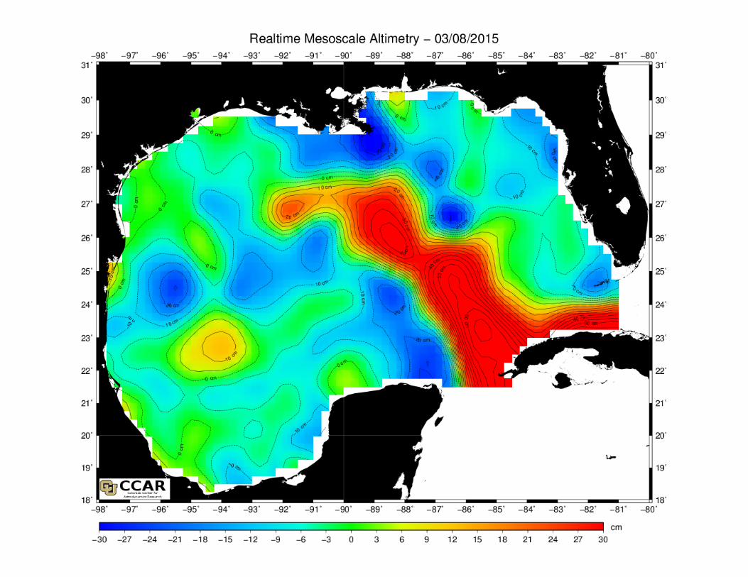
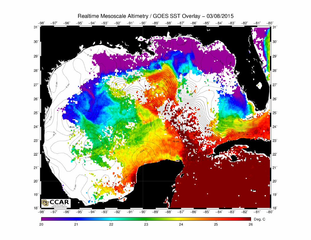
! The quick-look processing was designed to map mesoscale sea surface height (SSH) variability in the Gulf of Mexico.
! In early 1996, processing was sufficiently optimized so that “global” maps could be made of mesoscale SSH anomaly and posted online at CCAR daily by 12:00 p.m. MST.
! Developed with NASA Ocean Surface Topography Science Team (OSTST) and NASA/JPL Outreach Grants.
! Was the first operational “online” near real-time ocean altimeter data system.
Colorado Center for Astrodynamics Research University of Colorado Boulder GCOOS BOD Meeting • March 11-12, 2015
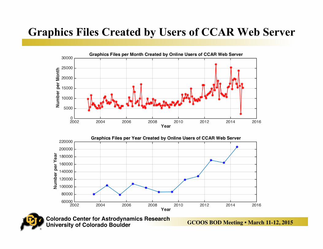
Graphics Files Created by Users of CCAR Web Server
Colorado Center for Astrodynamics Research University of Colorado Boulder GCOOS BOD Meeting • March 11-12, 2015
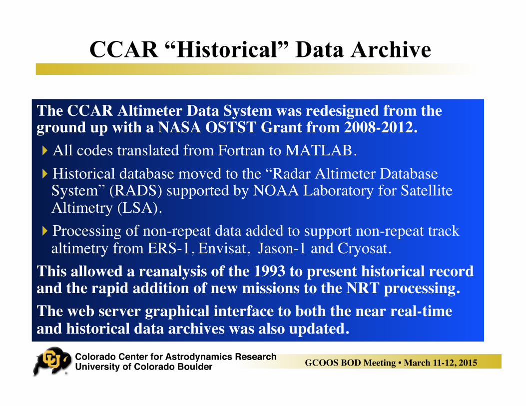
CCAR “Historical” Data Archive
The CCAR Altimeter Data System was redesigned from the ground up with a NASA OSTST Grant from 2008-2012.! All codes translated from Fortran to MATLAB.! Historical database moved to the “Radar Altimeter Database
System” (RADS) supported by NOAA Laboratory for Satellite Altimetry (LSA).
! Processing of non-repeat data added to support non-repeat track altimetry from ERS-1, Envisat, Jason-1 and Cryosat.
This allowed a reanalysis of the 1993 to present historical record and the rapid addition of new missions to the NRT processing.The web server graphical interface to both the near real-time and historical data archives was also updated.
Colorado Center for Astrodynamics Research University of Colorado Boulder GCOOS BOD Meeting • March 11-12, 2015
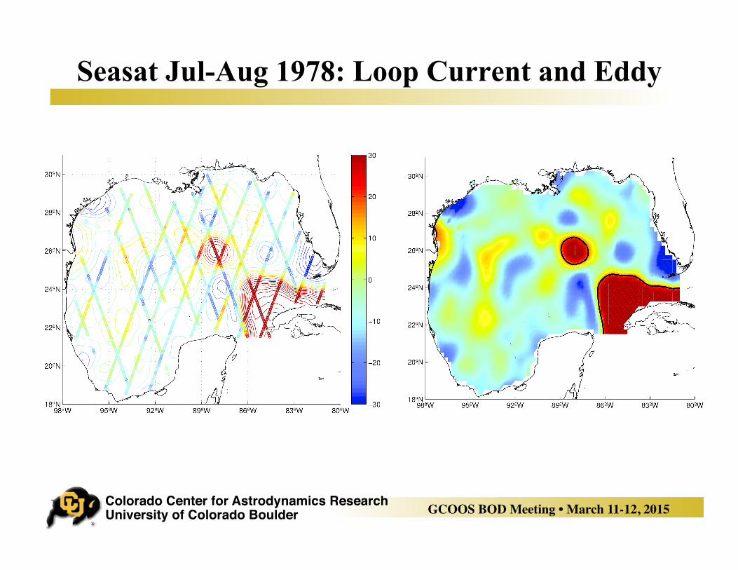
Seasat Jul-Aug 1978: Loop Current and Eddy
Colorado Center for Astrodynamics Research University of Colorado Boulder GCOOS BOD Meeting • March 11-12, 2015
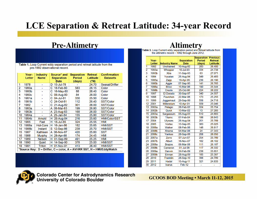
LCE Separation & Retreat Latitude: 34-year Record
Pre-Altimetry Altimetry
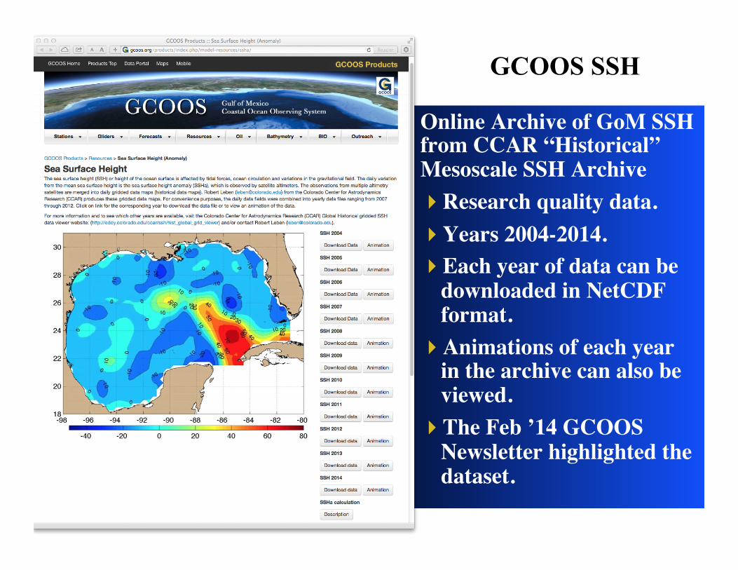
GCOOS SSH
Online Archive of GoM SSH from CCAR “Historical” Mesoscale SSH Archive! Research quality data.! Years 2004-2014.! Each year of data can be
downloaded in NetCDF format.
! Animations of each year in the archive can also be viewed.
! The Feb ’14 GCOOS Newsletter highlighted the dataset.
Colorado Center for Astrodynamics Research University of Colorado Boulder GCOOS BOD Meeting • March 11-12, 2015
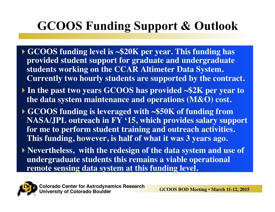
GCOOS Funding Support & Outlook
! GCOOS funding level is ~$20K per year. This funding has provided student support for graduate and undergraduate students working on the CCAR Altimeter Data System. Currently two hourly students are supported by the contract.
! In the past two years GCOOS has provided ~$2K per year to the data system maintenance and operations (M&O) cost.
! GCOOS funding is leveraged with ~$50K of funding from NASA/JPL outreach in FY ‘15, which provides salary support for me to perform student training and outreach activities. This funding, however, is half of what it was 3 years ago.
! Nevertheless, with the redesign of the data system and use of undergraduate students this remains a viable operational remote sensing data system at this funding level.
Colorado Center for Astrodynamics Research University of Colorado Boulder GCOOS BOD Meeting • March 11-12, 2015
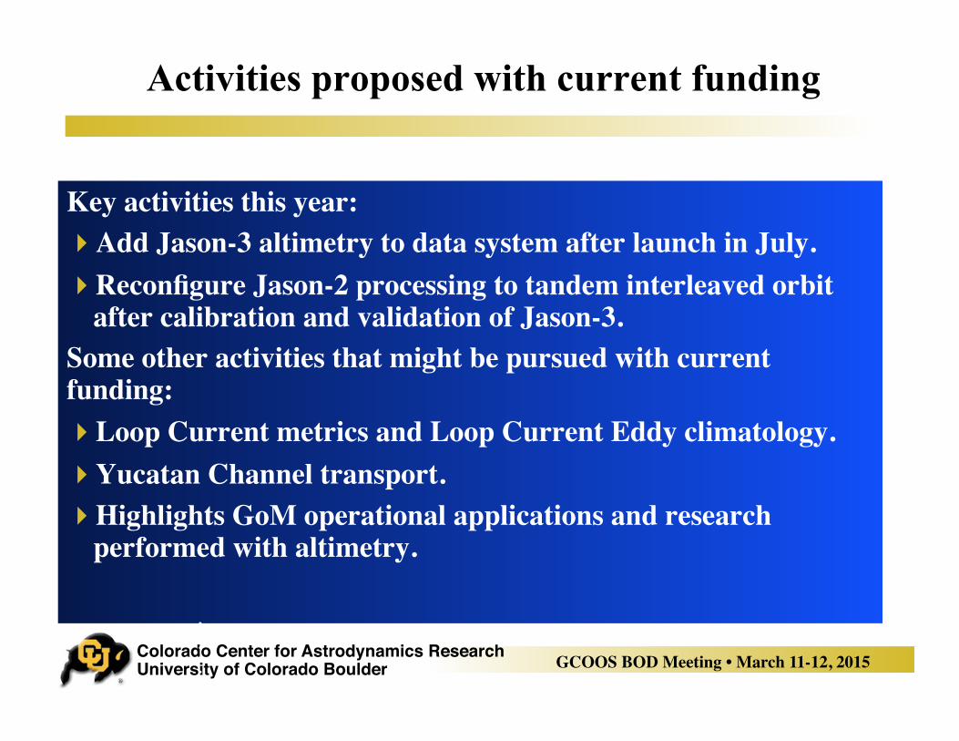
Activities proposed with current funding
Key activities this year:! Add Jason-3 altimetry to data system after launch in July.! Reconfigure Jason-2 processing to tandem interleaved orbit
after calibration and validation of Jason-3.Some other activities that might be pursued with current funding:! Loop Current metrics and Loop Current Eddy climatology.! Yucatan Channel transport.! Highlights GoM operational applications and research
performed with altimetry.
.
.
.
.
Colorado Center for Astrodynamics Research University of Colorado Boulder GCOOS BOD Meeting • March 11-12, 2015
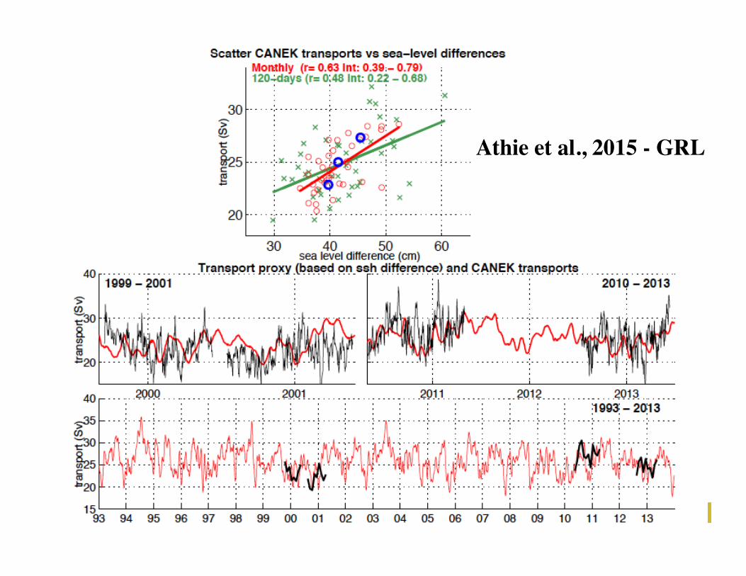
Athie et al., 2015 - GRL
Colorado Center for Astrodynamics Research University of Colorado Boulder GCOOS BOD Meeting • March 11-12, 2015
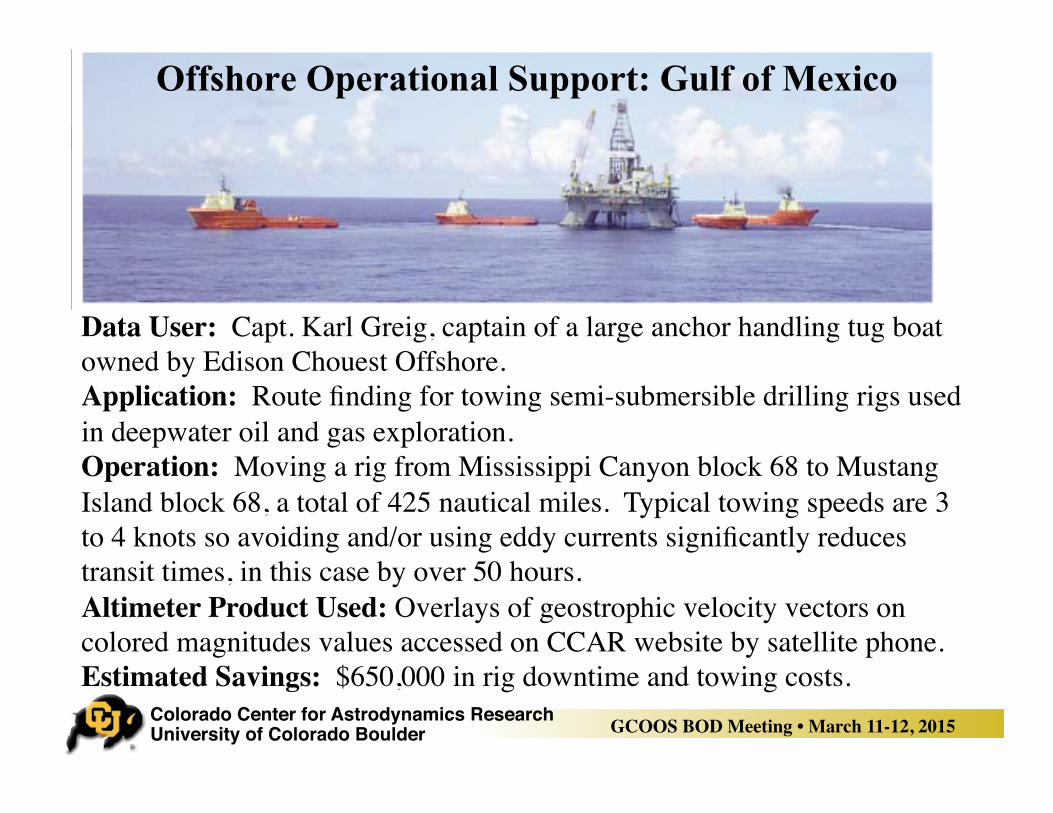
Offshore Operational Support: Gulf of Mexico
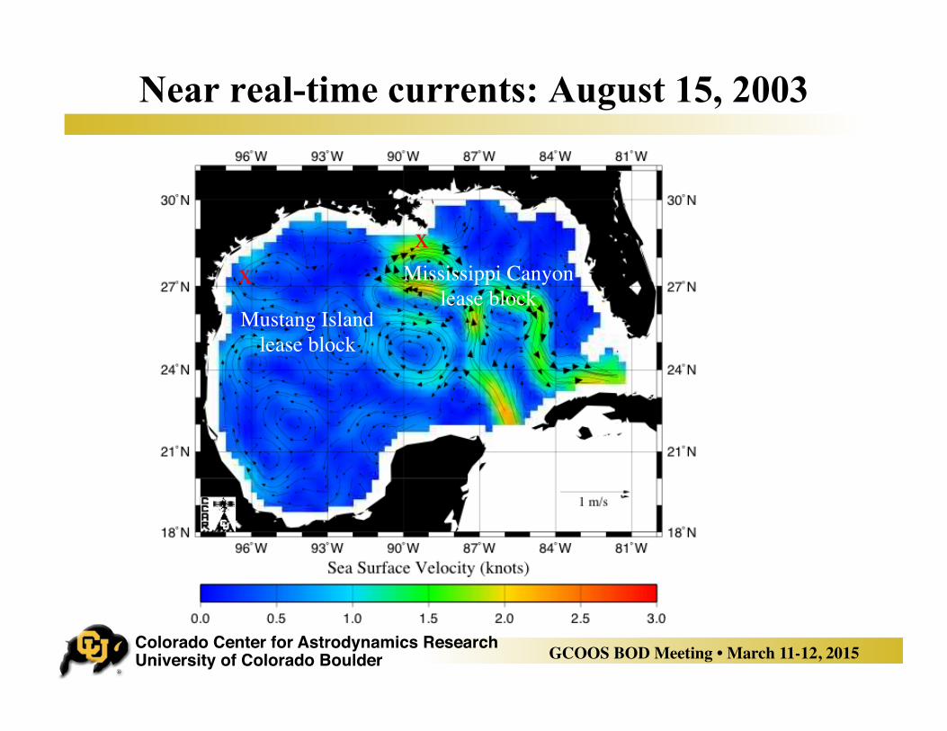
Data User: Capt. Karl Greig, captain of a large anchor handling tug boat owned by Edison Chouest Offshore.Application: Route finding for towing semi-submersible drilling rigs used in deepwater oil and gas exploration. Operation: Moving a rig from Mississippi Canyon block 68 to Mustang Island block 68, a total of 425 nautical miles. Typical towing speeds are 3 to 4 knots so avoiding and/or using eddy currents significantly reduces transit times, in this case by over 50 hours. Altimeter Product Used: Overlays of geostrophic velocity vectors on colored magnitudes values accessed on CCAR website by satellite phone.Estimated Savings: $650,000 in rig downtime and towing costs.
Colorado Center for Astrodynamics Research University of Colorado Boulder GCOOS BOD Meeting • March 11-12, 2015
Near real-time currents: August 15, 2003
xx Mustang Island
lease block
Mississippi Canyonlease block
Colorado Center for Astrodynamics Research University of Colorado Boulder GCOOS BOD Meeting • March 11-12, 2015
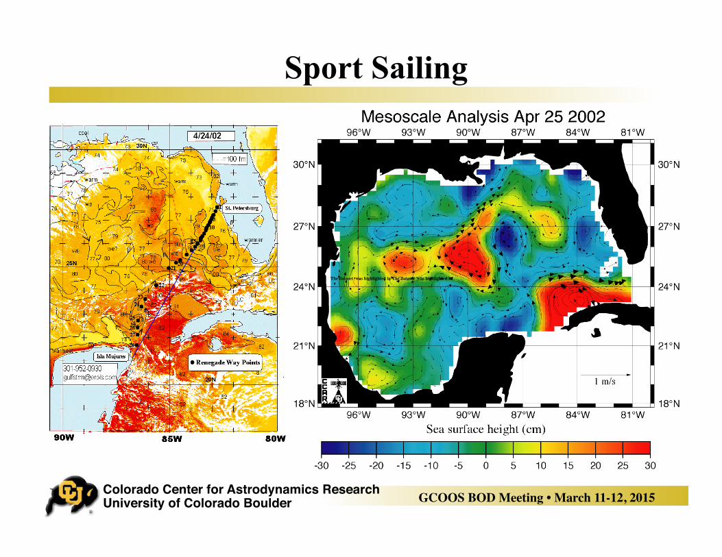
Sport Sailing
The dataset was highlighted in The dataset was highlighted in
Colorado Center for Astrodynamics Research University of Colorado Boulder GCOOS BOD Meeting • March 11-12, 2015
THANKS!
Recommended