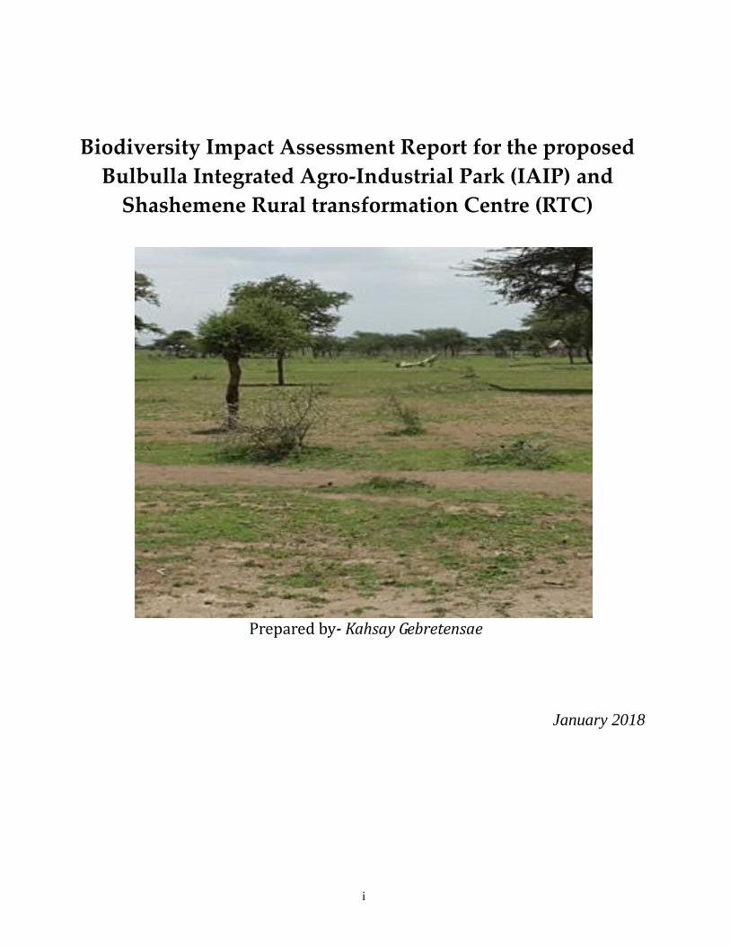
i
Biodiversity Impact Assessment Report for the proposed
Bulbulla Integrated Agro-Industrial Park (IAIP) and
Shashemene Rural transformation Centre (RTC)
Prepared by- Kahsay Gebretensae
January 2018
ii
Table of contents Page
1. Introduction ………………………………………………………………………..1
2. Project Area Baselines……………………………………………………………….1
2.1. Physical Conditions.…………………………………………………………..1
i. Location and Topography………………………………………………………1
ii. Climate …………………………………………………………………………….2
2.2. Flora and Fauna …………………………………………………………….…2
i. Flora …………………………………………………………………………….....2
ii. Fauna ………………………………………………………………………………3
iii. Species of Conservation Concern ……………………………………………….4
2.3. Protected and Non Protected Biodiversity Sites..………………………….4
i. Protected Areas……………………………………………………………………..4
ii. Wetlands………………………………………………………………………….....9
3 Shashemene RTC …………………………………………………………………10
4 Impact Assessment and Mitigation for Bulbulla IAIP and
Shashemene RTC…………………………………………………………………....11
i) Assessment Methodology ……………………………………………………….11
ii) Bulbulla IAIP - Impact Description and Mitigation Measures……………..12
iii) Shashemene RTC - Impact Description and Mitigation Measures………….17
iv) Residual Impacts and Conclusion………………………………………………21
5 References/ Bibliography…………………………………………………………22
6 Annexes…………………………………………………………………………............24
1
Biodiversity Impact Assessment Report for the proposed Bulbulla
Integrated Agro-Industrial Park (IAIP) and Shashemene Rural
transformation Centre (RTC)
1. Introduction This section provides a description of the existing biodiversity components and associated key
features which include typical flora and fauna, protected areas and non protected sensitive
resources that are found inside and within the vicinity of the project sites. The baseline
conditions within the proposed project areas have been determined through desk-based
reviews of available information, field surveys and consultations with concerned authorities.
2. Project Area Baselines
2.1. Physical Conditions
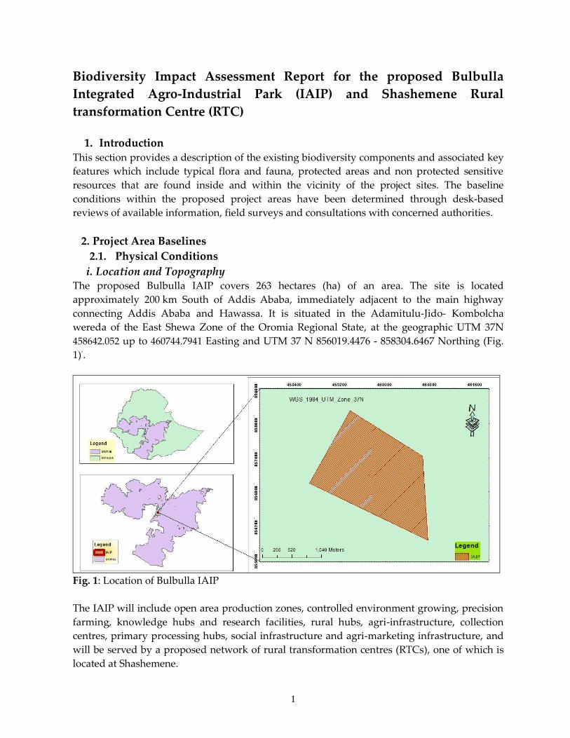
i. Location and Topography The proposed Bulbulla IAIP covers 263 hectares (ha) of an area. The site is located
approximately 200 km South of Addis Ababa, immediately adjacent to the main highway
connecting Addis Ababa and Hawassa. It is situated in the Adamitulu-Jido- Kombolcha
wereda of the East Shewa Zone of the Oromia Regional State, at the geographic UTM 37N
458642.052 up to 460744.7941 Easting and UTM 37 N 856019.4476 - 858304.6467 Northing (Fig.
1)’.
Fig. 1: Location of Bulbulla IAIP
The IAIP will include open area production zones, controlled environment growing, precision
farming, knowledge hubs and research facilities, rural hubs, agri-infrastructure, collection
centres, primary processing hubs, social infrastructure and agri-marketing infrastructure, and
will be served by a proposed network of rural transformation centres (RTCs), one of which is
located at Shashemene.
2
ETHIOPIA
The Bulbulla IAIP is situated in the lower northern part of the Great Rift Valley at an average
altitude of 1,650masl. The northern floor of the rift valley was previously occupied by one
large lake, of which Lakes Ziway, Abijata and Langano are remnants, occurring at altitudes of
around 1,640 m for Ziway and 1,580 m for the other lakes. This broad flat plain is cut by the
Mareko Ridge running from Koshe to Aje to the west of the lakes. The specific site for the
proposed industrial park is characterized by similar topography of flat floored landscape.
ii. Climate The climate of the project area is characterized by a semi-arid climatic zone. The maximum
and minimum temperature of the project site ranges between 22.50C and 28.20C, and between
10.30C and 16.10C respectively. The dry season, which occurs from late October through
January, is the period of the lowest monthly daytime and night time temperatures.
The mean annual precipitation from the three adjoining meteorological stations, namely the
Adami Tulu, Bulbulla and Ziway stations, are 113.18mm, 57.34mm and 72.72mm, respectively.
Rainfall in the site and its surroundings occurs during two distinct rainy seasons, the “small”
rains and the “big” rains. The small rains, which usually begin in February and go to the end
of April, and the big rains, which are more reliable, occur from July through September.
2.2. Flora and Fauna
i. Flora As there is no significant variation in altitude and habitat range, the vegetation types of the
project area are categorized into transformed scattered woodland and open grassland. The
woodland areas are characterized by Acacia seyal, Acacia tortilis, Acacia senegal and Balanites
aegyptiaca. Along the edge of the abandoned and present cultivation areas of crops,
consistingmainly of maize, Opuntia cactus and Euphorbia tirucalli have been used as enclosures
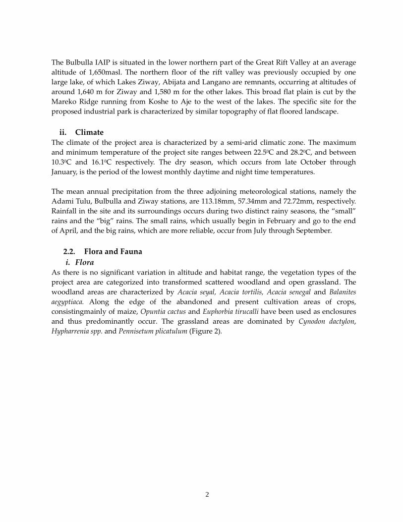
and thus predominantly occur. The grassland areas are dominated by Cynodon dactylon,
Hypharrenia spp. and Pennisetum plicatulum (Figure 2).
3
Fig. 2: Grassland areas covered by Cynodon dactylon at Bulbulla IAIP
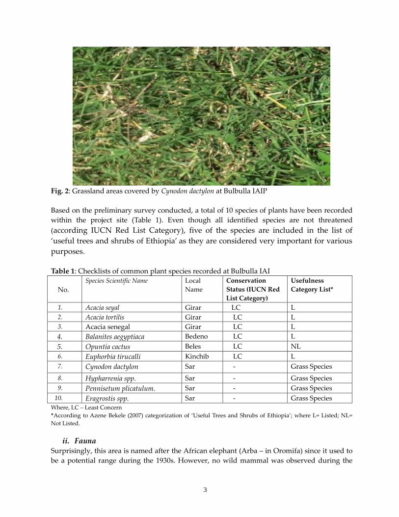
Based on the preliminary survey conducted, a total of 10 species of plants have been recorded
within the project site (Table 1). Even though all identified species are not threatened
(according IUCN Red List Category), five of the species are included in the list of
‘useful trees and shrubs of Ethiopia’ as they are considered very important for various
purposes.
Table 1: Checklists of common plant species recorded at Bulbulla IAI
No.
Species Scientific Name Local
Name
Conservation
Status (IUCN Red
List Category)
Usefulness
Category List*
1. Acacia seyal Girar LC L
2. Acacia tortilis Girar LC L
3. Acacia senegal Girar LC L
4. Balanites aegyptiaca Bedeno LC L
5. Opuntia cactus Beles LC NL
6. Euphorbia tirucalli Kinchib LC L
7. Cynodon dactylon Sar - Grass Species
8. Hypharrenia spp. Sar - Grass Species
9. Pennisetum plicatulum. Sar - Grass Species
10. Eragrostis spp. Sar - Grass Species
Where, LC – Least Concern
*According to Azene Bekele (2007) categorization of ‘Useful Trees and Shrubs of Ethiopia’; where L= Listed; NL=
Not Listed.
ii. Fauna Surprisingly, this area is named after the African elephant (Arba – in Oromifa) since it used to
be a potential range during the 1930s. However, no wild mammal was observed during the
4
field survey except foot prints of Spotted Hyena (Crocuta crocuta) and Egyptian Mongoose
(Herpestes ichneumon). According to local informants the area is located within the home range
of various other species including Warthog (Phacochoerus africanus) Aardvark (Orycteropus
afer), Common Jackal (Canis aureus), Bat-eared Fox (Otocyon megalotis), Wild Cat (Felis
sylvestris), Abyssinian Hare (Lepus habessinicus) and Crested porcupine (Hystrix cristata).
Cattle (ox, cow), sheep, goat and equids are among the domestic animals largely reared by the
local residents and thus they are part of the existing biodiversity.
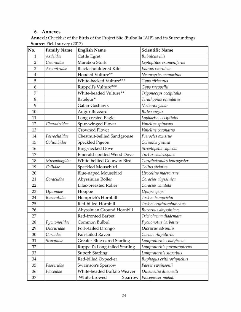
This site is also a location for numerous species of birds. During the survey, 40 species, which
constitute 18 avian families, were recorded in the site and its environs (Annex1). The dominant
bird species in the area include Ruppell’s Long-tailed Starling (Lamprotornis pururopterus),
Superb Starling (Lamprotornis superbus), White-browed Sparrow weaver (Plocepasser mahali),
Northern Masked Weaver (Ploceus taeniopterus), Fan-tailed Raven (Corvus rhipidurus), Emerald-
spotted Wood Dove (Turtur chalcospilos), Ring-necked Dove (Streptopelia capicola), Spur-winged
Plover (Vanellus spinosus), Gabar Goshawk (Melierax gabar) and Augur Buzzard (Buteo augur).
iii. Species of Conservation Concern Considering the specific project site, no threatened wild mammal is found in the area.
However, among the avian species observed at the proposed Bulbulla IAIP about 4 species of
birds (all vultures) are critically endangered or endangered and one species (Bateleur) is near
threatened though they are found abundantly throughout Ethiopia (Table 2).
Table 2: List of Threatened Bird Species of the Project Site
N
o
Species Common
Name
Scientific Name Conservation
Status (IUCN Red List
Category)
1 Bateleur Terathopius ecaudatus NT
2 Hooded Vulture Necrosyrtes monachus EN
3 White-backed Vulture Gyps africanus CEN
4 Ruppell’s Vulture Gyps rueppellii CEN
5 White-headed Vulture Trigonoceps occipitalis EN Where NT – Near Threatened; EN – Endangered; CEN – Critically Endangered
2.3. Protected and Non Protected Biodiversity Sites
i. Protected Areas According to the existing wildlife laws of Ethiopia, there are four clearly defined and one
indirectly explained category of Protected Areas (PAs) and all PAs and their IUCN
conservation status is indicated below (Table 3).
Table 3: Categories of Protected Areas (PAs) in Ethiopia and their Conservation Status
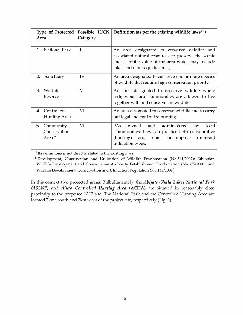
5
Type of Protected
Area
Possible IUCN
Category
Definition (as per the existing wildlife laws**)
1. National Park II An area designated to conserve wildlife and
associated natural resources to preserve the scenic
and scientific value of the area which may include
lakes and other aquatic areas;
2. Sanctuary IV An area designated to conserve one or more species
of wildlife that require high conservation priority
3. Wildlife
Reserve
V An area designated to conserve wildlife where
indigenous local communities are allowed to live
together with and conserve the wildlife
4. Controlled
Hunting Area
VI An area designated to conserve wildlife and to carry
out legal and controlled hunting
5. Community
Conservation
Area *
VI PAs owned and administered by local
Communities; they can practice both consumptive
(hunting) and non consumptive (tourism)
utilization types.
*Its definitions is not directly stated in the existing laws,
**Development, Conservation and Utilization of Wildlife Proclamation (No.541/2007); Ethiopian
Wildlife Development and Conservation Authority Establishment Proclamation (No.575/2008); and
Wildlife Development, Conservation and Utilization Regulation (No.163/2008).
In this context two protected areas, Bulbullanamely: the Abijata-Shala Lakes National Park
(ASLNP) and Aluto Controlled Hunting Area (ACHA) are situated in reasonably close
proximity to the proposed IAIP site. The National Park and the Controlled Hunting Area are
located 7kms south and 7kms east of the project site, respectively (Fig. 3).
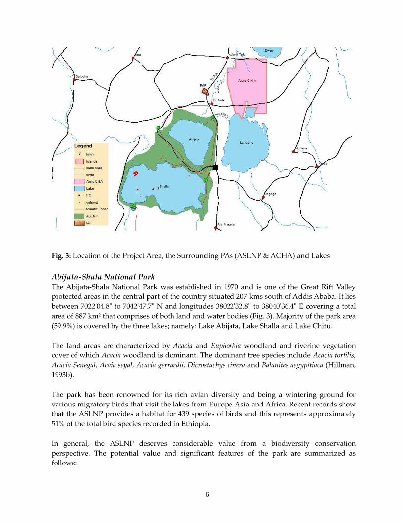
6
Fig. 3: Location of the Project Area, the Surrounding PAs (ASLNP & ACHA) and Lakes
Abijata-Shala National Park The Abijata-Shala National Park was established in 1970 and is one of the Great Rift Valley
protected areas in the central part of the country situated 207 kms south of Addis Ababa. It lies
between 7022'04.8" to 7042'47.7" N and longitudes 38022'32.8" to 38040'36.4" E covering a total
area of 887 km2 that comprises of both land and water bodies (Fig. 3). Majority of the park area
(59.9%) is covered by the three lakes; namely: Lake Abijata, Lake Shalla and Lake Chitu.
The land areas are characterized by Acacia and Euphorbia woodland and riverine vegetation
cover of which Acacia woodland is dominant. The dominant tree species include Acacia tortilis,
Acacia Senegal, Acaia seyal, Acacia gerrardii, Dicrostachys cinera and Balanites aegypitiaca (Hillman,
1993b).
The park has been renowned for its rich avian diversity and being a wintering ground for
various migratory birds that visit the lakes from Europe-Asia and Africa. Recent records show
that the ASLNP provides a habitat for 439 species of birds and this represents approximately
51% of the total bird species recorded in Ethiopia.
In general, the ASLNP deserves considerable value from a biodiversity conservation
perspective. The potential value and significant features of the park are summarized as
follows:
7
The ASLNP is the richest wetland in avian diversity and abundance in the country;
The park is the location for three lakes and it is one of the few protected areas of Africa
established to conserve wetland diversity;
It is one of the scenically beautiful locations of Ethiopia that comprise of hot springs
and blue lakes fringed with flat-topped Acacia trees;
It is a location of four islands that secure nesting and breeding sites for a large number
of waterfowls;
It is a place where thousands of Lesser Flamingos are observed;
The park is an important feeding ground for the Great White Pelican in the country;
It comprises 122 out of the 196 wetland bird species listed by the IWRB for eastern
Africa waterfowl census;
ASLNP serves as wintering ground for 108 palearctic migrant bird species; and
It is selected as an Important Bird Area (IBA) for holding globally threatened species,
including the Lesser Flamingo, Pallid Harrier, Basra reed warbler and Black-winged
Pratincole.
However, the ASLNP has been under serious threat from overexploitation of its natural
resources including water extraction, overgrazing, expansion of cultivation and settlements
that are accompanied by excessive deforestation, siltation, key wild habitat loss and
fragmentation as well as transformation of the natural ecosystems. These serious challenges
are still threatening much of the park area and its vegetation and water coverage has been
dwindling overtime and the population of key species is dramatically declining (Fekadu and
Abdi, 2013; EWCA, 2015; ERM and ESSD, 2013).
Taking into account the ever-increasing anthropogenic pressures in and around the park, re-
demarcation of the ASLNP is being undertaken and this process will take into consideration
the existing ecological and socio-economic conditions of the area. Following this, a General
Management Plan (GMP) that comprises of at least five programs is to be developed and be
used as a guideline for the conservation and development of the ASLNP.
Moreover, the water of Lake Abijatta has been used for soda ash production by a factory
located west of Bulbulla town. This factory abstracts two million cubic metres of water
annually and it is considered that this level of water use significantly contributes to the
declining water levels of the lake (ERM and ESSD, 2013). Considering this, a study is currently
being undertaken to determine the sustainability of the existing abstraction and Soda ash
factory.
Similarly the Bulbulla River, which connects Lake Abijatta to its main source of water the
much larger freshwater Lake Ziway, has been under pressure due to continuous unregulated
use of water by the surrounding large and small scale farms. As a result, the river has stopped
flowing along its former courses. Therefore, an initiative that involves all stakeholders and
aims at ensuring equitable and sustainable use of water has been started in which an annual
water allocation plan is to be developed and implemented.
8
Aluto CHA The Aluto Controlled Hunting Area (ACHA) is one of the eighteen protected areas in Ethiopia
set aside to practice regulated hunting of wild animals. The ACHA covers 202 km2 of an area is
located about 200km South of Addis Ababa. The geographical location of the controlled
hunting area lies between: UTM 37N 467000 up to 480000 Easting and UTM 37 N 848000 up to
868000 N. The topography of the controlled hunting is characterized by hilly terrain that
ranges between 1700masl and 2367masl in altitude (Kahsay et.al, (2008); Temesgen and
Endaweke, 2014).
The vegetation of the area is mainly characterized by semi– arid zone shrubs and tree species.
The dominant woody plant species include Dodonaea viscosa, Combretum molle, and Erica arborea,
Carissa edulis, Ficus sycomorus, Ficus vasta, Rhus natalensis, Acacia albida (Faidherbia albida), Acacia
tortilis and Acacia seyal.
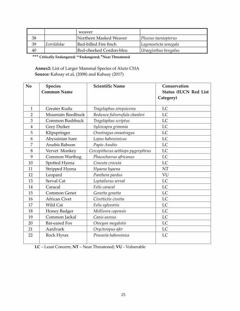
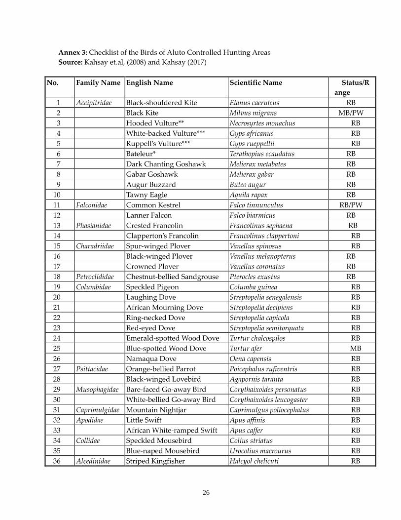
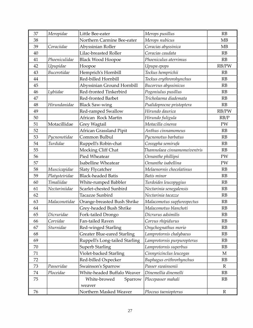
The ACHA provides habitats for at least 22 species of mammals and 82 species of birds,
(Annex 2 and 3). It is renowned for its huntable ungulate populations. These include Greater
kudu (Tragelaphus strepsiceros), Mountain reedbuck (Redunca fulvorufula chanleri), and Common
bushbuck (Tragelaphus scriptus). Other wild animals found within the controlled hunting area
comprises of Leopard (Panthera pardus), Spotted hyena (Crocuta crocuta), Striped hyena (Hyaena
hyaena), Black backed jackal (Canais mesomelas), Bat-eared fox (Otocyon megalotis), Caracal (Felis
caracal) and Serval cat (Leptailurus serval).
The dominant bird species in the ACHA are White-browed sparrow weaver, Hemprich’s
hornbill, Black-shouldered kite, Black kite, Gabar goshawk, Common kestrel, Bare-faced Go-
away Bird, Black wood hoopoe and considerable number of starling and vulture species.
According to the IUCN Red Listing, six species of mammals and birds that are found in the
ACHA fall into near threatened, vulnerable, endangered and critically endangered categories.
Both Stripped Hyena (Hyaena hyaena) and Bateleur (Terathopius ecaudatus) are near threatened
and Leopard (Panthera pardus) is vulnerable. The endangered or critically endangered category
is filled by three species of vultures (Hodded, White-backed and Ruppell’s vultures).
The ACHA is currently managed by a concessionaire (hunting Company) and concerned
offices of both Federal government and the Oromia Regional States conduct a census every
three year to set quotas for hunting in order to ensure sustainable utilization. During the
census, habitat condition and associated ecological aspects are also assessed to examine the
management and conservation efforts in the area. Moreover, additional monitoring systems
are put in place in case there are environmental stresses that adversely affect natural habitats
of the hunting area.
9
ii. Wetlands
The proposed Bulbulla IAIP site is located close to the Bulubula River and associated Lake
Langano and their surroundings. In the past, the Bulbulla River was known to be the main
feeder to Lake Abijatta and now days, as indicated above, the River does not flow during the
dry seasons due to unsustainable utilization of water at lake Ziway and other upstream areas.
Lake Langano is situated 11kms (~10kms of surrounding wetlands) South East of the
Industrial Park (Fig. 3). Geographically, it is located at the co-ordinates of N07° 032′ 18″ E038°
41′05.4″ and its altitude is 1586masl. It has a total surface area of 241km2 and is one of the biggest
lakes in the rift valley system of Ethiopia with an unusually reddish brown water color
because of its geological formation which is attributed to high amount of silt containing iron
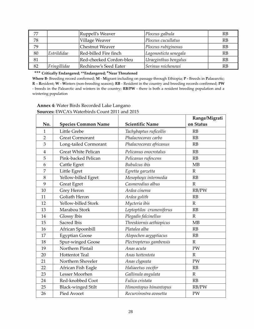
compounds (Wood and Talling 1988; EWCA, 2015). The lake is known to support a high
diversity and abundance of bird species and is a feeding and roosting site of birds like the
Grey-headed Gulls, Cormorants, Herons and Pelicans.
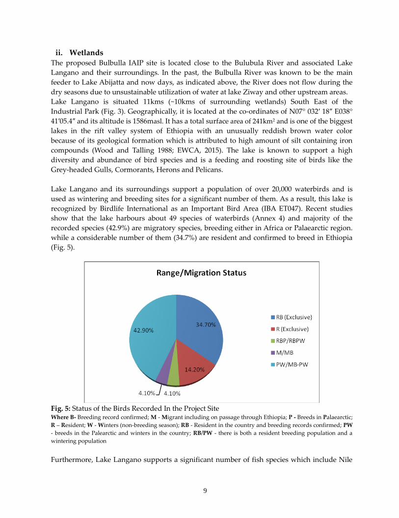
Lake Langano and its surroundings support a population of over 20,000 waterbirds and is
used as wintering and breeding sites for a significant number of them. As a result, this lake is
recognized by Birdlife International as an Important Bird Area (IBA ET047). Recent studies
show that the lake harbours about 49 species of waterbirds (Annex 4) and majority of the
recorded species (42.9%) are migratory species, breeding either in Africa or Palaearctic region.
while a considerable number of them (34.7%) are resident and confirmed to breed in Ethiopia
(Fig. 5).
Fig. 5: Status of the Birds Recorded In the Project Site Where B- Breeding record confirmed; M - Migrant including on passage through Ethiopia; P - Breeds in Palaearctic;
R – Resident; W - Winters (non-breeding season); RB - Resident in the country and breeding records confirmed; PW
- breeds in the Palearctic and winters in the country; RB/PW - there is both a resident breeding population and a
wintering population
Furthermore, Lake Langano supports a significant number of fish species which include Nile
10
tilapia and African Catfish. However, the commercial fish catch has been declining over the
past decade indicating the population of important fish is declining overtime. The lake is also a
location for significant population of Hippopotamus (Hippopotamus amphibius) though studies
show they are at their population decline stage. According to IUCN Red listing,
Hippopotamus is categorized as vulnerable. Lesser flamingo (Phoeniconaias minor) which is
threatened is also another species of conservation concern inhabiting in the lake.
The Langano Sub-Basin is a closed sub-basin sensitive to natural and human impacts. Human
impact together with changing climate is significantly affecting natural resources in the Sub-
Basin. Besides, there is a high level of water abstraction and pollution by local investments
putting pressure on ecosystems and biodiversity in the area.
Understanding the challenges posed on the water bodies like Lake Langano, the Rift Valley
Lakes Basin Integrated Resources Development Master Plan was developed about a decade
ago. Following which the Rift Valley Lakes Basin Authority (RVLBA), which is responsible to
implement the master plan, was established. The RVLBA in collaboration with stakeholders
has devised a mechanism that aims to develop a socially equitable and economically viable
water allocation plan that also recognizes ecosystem water flow requirements. Therefore, once
the designed water allocation plan is adopted by the concerned body upon agreement of all
users, relevant government offices and the wider community, it is expected to be effectively
implemented and hence ensure sustainable water use.
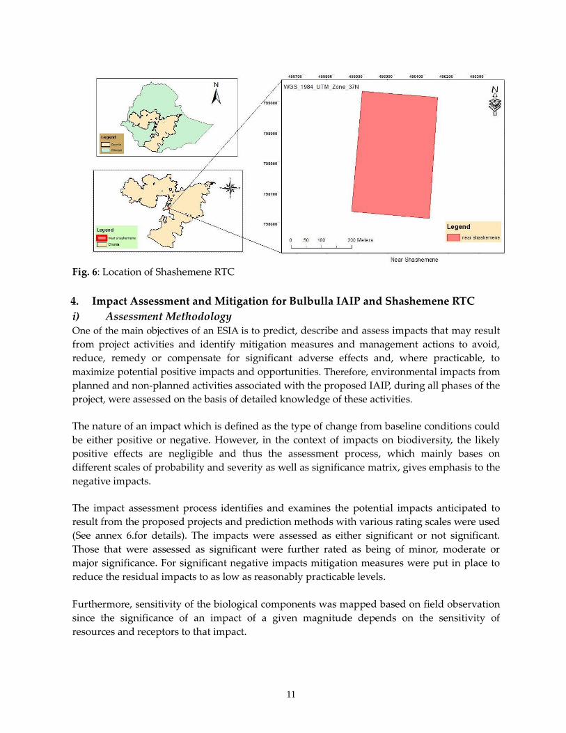
3. Shashemene RTC The proposed Shashemene RTC is located 250km South of Addis Ababa, on the northern
outskirts of Shashemene town. It is situated at the geographic UTM 37N 455882.924 - 456165.923
Easting and UTM 37 N 798692.665 - 799112.659 Northing (Fig. 6). This proposed RTC is the pilot
facility of the proposed network of rural transformation centres which will feed the necessary
inputs for the Bulbulla IAIP.
The proposed Shashemene RTC site is situated in the cultivation areas around Shashemene
town. Throughout the cultivation areas, there are highly scattered trees of Acacia albida, and
Croton macrostachyus and the site is more or less transformed to urban area. During the field
observation, no IUCN red data listed species were recorded and there is no protected area of
any category in the vicinity. Therefore, this RTC is neither a site of conservation concern nor a
location for biodiversity priority areas.
11
Fig. 6: Location of Shashemene RTC
4. Impact Assessment and Mitigation for Bulbulla IAIP and Shashemene RTC
i) Assessment Methodology One of the main objectives of an ESIA is to predict, describe and assess impacts that may result
from project activities and identify mitigation measures and management actions to avoid,
reduce, remedy or compensate for significant adverse effects and, where practicable, to
maximize potential positive impacts and opportunities. Therefore, environmental impacts from
planned and non-planned activities associated with the proposed IAIP, during all phases of the
project, were assessed on the basis of detailed knowledge of these activities.
The nature of an impact which is defined as the type of change from baseline conditions could
be either positive or negative. However, in the context of impacts on biodiversity, the likely
positive effects are negligible and thus the assessment process, which mainly bases on
different scales of probability and severity as well as significance matrix, gives emphasis to the
negative impacts.
The impact assessment process identifies and examines the potential impacts anticipated to
result from the proposed projects and prediction methods with various rating scales were used
(See annex 6.for details). The impacts were assessed as either significant or not significant.
Those that were assessed as significant were further rated as being of minor, moderate or
major significance. For significant negative impacts mitigation measures were put in place to
reduce the residual impacts to as low as reasonably practicable levels.
Furthermore, sensitivity of the biological components was mapped based on field observation
since the significance of an impact of a given magnitude depends on the sensitivity of
resources and receptors to that impact.
12
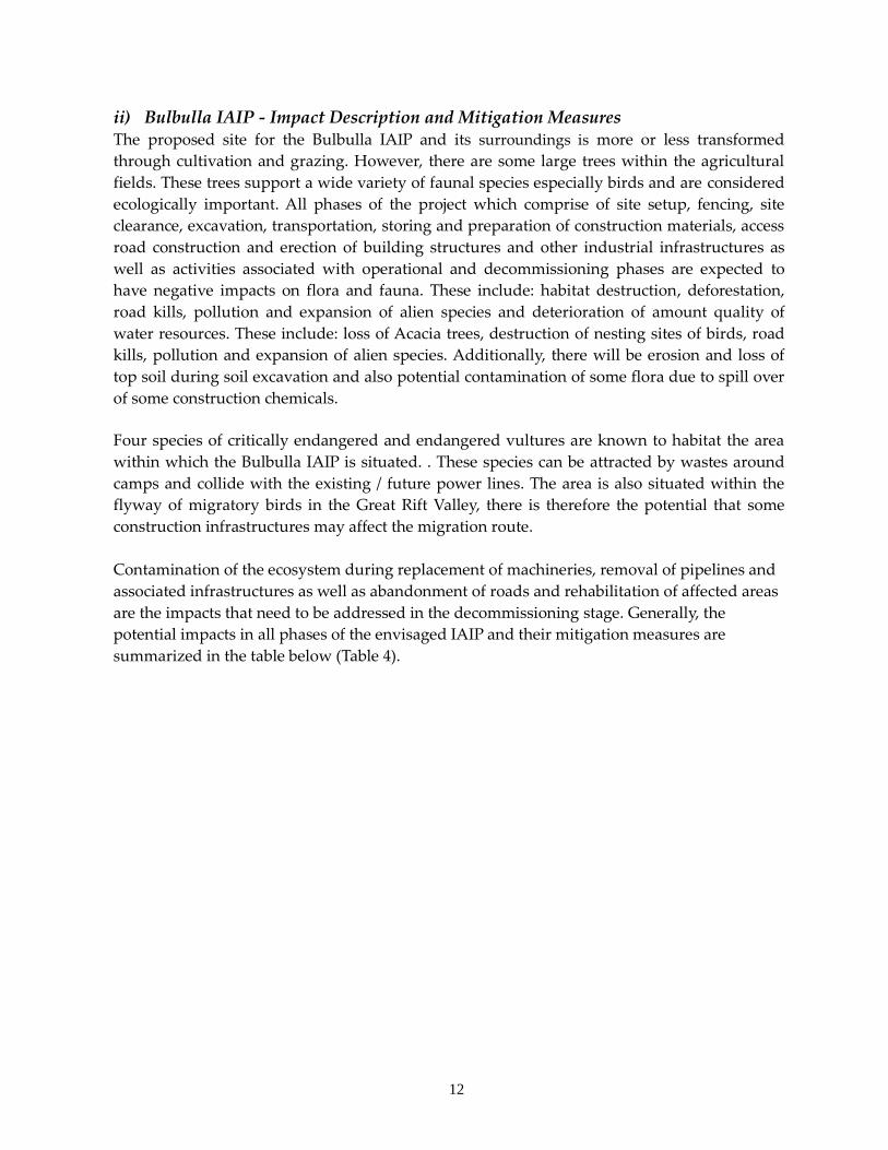
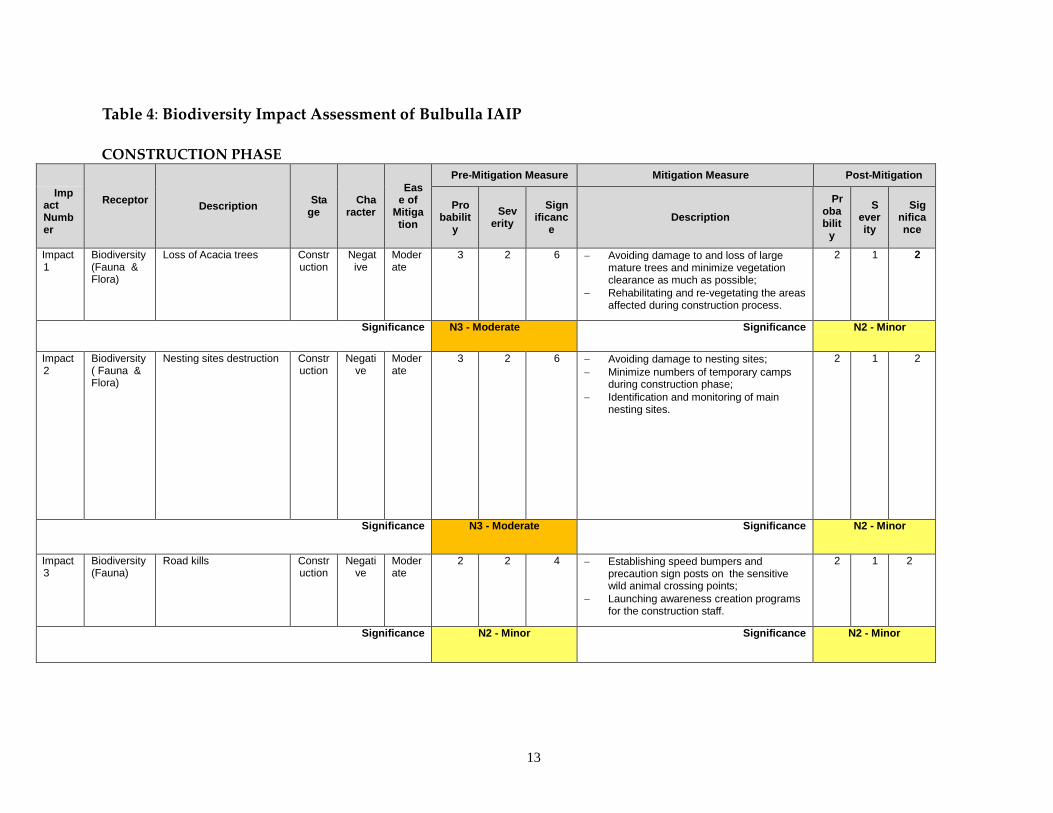
ii) Bulbulla IAIP - Impact Description and Mitigation Measures The proposed site for the Bulbulla IAIP and its surroundings is more or less transformed
through cultivation and grazing. However, there are some large trees within the agricultural
fields. These trees support a wide variety of faunal species especially birds and are considered
ecologically important. All phases of the project which comprise of site setup, fencing, site
clearance, excavation, transportation, storing and preparation of construction materials, access
road construction and erection of building structures and other industrial infrastructures as
well as activities associated with operational and decommissioning phases are expected to
have negative impacts on flora and fauna. These include: habitat destruction, deforestation,
road kills, pollution and expansion of alien species and deterioration of amount quality of
water resources. These include: loss of Acacia trees, destruction of nesting sites of birds, road
kills, pollution and expansion of alien species. Additionally, there will be erosion and loss of
top soil during soil excavation and also potential contamination of some flora due to spill over
of some construction chemicals.
Four species of critically endangered and endangered vultures are known to habitat the area
within which the Bulbulla IAIP is situated. . These species can be attracted by wastes around
camps and collide with the existing / future power lines. The area is also situated within the
flyway of migratory birds in the Great Rift Valley, there is therefore the potential that some
construction infrastructures may affect the migration route.
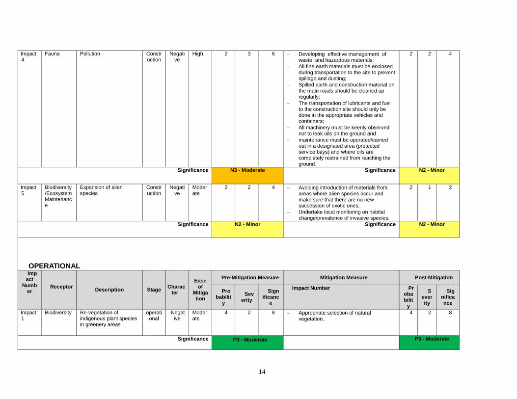
Contamination of the ecosystem during replacement of machineries, removal of pipelines and
associated infrastructures as well as abandonment of roads and rehabilitation of affected areas
are the impacts that need to be addressed in the decommissioning stage. Generally, the
potential impacts in all phases of the envisaged IAIP and their mitigation measures are
summarized in the table below (Table 4).
13
Table 4: Biodiversity Impact Assessment of Bulbulla IAIP
CONSTRUCTION PHASE
Receptor
Description Sta
ge Cha
racter
Ease of
Mitigation
Pre-Mitigation Measure Mitigation Measure Post-Mitigation
Impact Number
Probabilit
y
Severity
Significanc
e Description
Probabilit
y
Severity
Significance
Impact 1
Biodiversity (Fauna & Flora)
Loss of Acacia trees
Construction
Negative
Moderate
3 2 6 Avoiding damage to and loss of large mature trees and minimize vegetation clearance as much as possible;
Rehabilitating and re-vegetating the areas affected during construction process.
2 1 2
Significance N3 - Moderate Significance N2 - Minor
Impact 2
Biodiversity ( Fauna & Flora)
Nesting sites destruction Construction
Negative
Moderate
3 2 6 Avoiding damage to nesting sites;
Minimize numbers of temporary camps during construction phase;
Identification and monitoring of main nesting sites.
2 1 2
Significance N3 - Moderate Significance N2 - Minor
Impact 3
Biodiversity (Fauna)
Road kills Construction
Negative
Moderate
2 2 4 Establishing speed bumpers and precaution sign posts on the sensitive wild animal crossing points;
Launching awareness creation programs for the construction staff.
2 1 2
Significance N2 - Minor Significance N2 - Minor
14
Impact 4
Fauna Pollution Construction
Negative
High 2 3 6 Developing effective management of waste and hazardous materials;
All fine earth materials must be enclosed during transportation to the site to prevent spillage and dusting;
Spilled earth and construction material on the main roads should be cleaned up regularly;
The transportation of lubricants and fuel to the construction site should only be done in the appropriate vehicles and containers;
All machinery must be keenly observed not to leak oils on the ground and
maintenance must be operated/carried out in a designated area (protected service bays) and where oils are completely restrained from reaching the ground.
2 2 4
Significance N3 - Moderate Significance N2 - Minor
Impact 5
Biodiversity/Ecosystem Maintenance
Expansion of alien species
Construction
Negative
Moderate
2 2 4 Avoiding introduction of materials from areas where alien species occur and make sure that there are no new succession of exotic ones;
Undertake local monitoring on habitat change/prevalence of invasive species.
2 1 2
Significance N2 - Minor Significance N2 - Minor
OPERATIONAL Imp
act Numb
er Receptor
Description Stage Charac
ter
Ease of
Mitigation
Pre-Mitigation Measure Mitigation Measure Post-Mitigation
Probabilit
y
Severity
Significanc
e
Impact Number Probabilit
y
Severity
Significance
Impact 1
Biodiversity Re-vegetation of indigenous plant species in greenery areas
operational
Negative
Moderate
4 2 8 Appropriate selection of natural vegetation.
4 2 8
Significance P3 - Moderate
P3 - Moderate
15
Impact 2
Biodiversity/Avian fauna
Disturbance and Electrocutions of avian species
operational
Negative
Moderate
1 4 4 Undertake monitoring of the birds & their flyway on regular basis;
Use of birds friendly power lines and associated infrastructures.
1 2 2
Significance N2 - Minor Significance N2 - Minor
Impact 3
Biodiversity/Ecosystem Maintenance
Deterioration of water resources/quality
operational
Negative
Moderate
3 3 9 Developing effective watershed management plan for the area;
Support watershed conservation efforts in and around the project area;
Avoiding any uncontrolled drainage towards the surrounding water features;
Developing effective management of waste and hazardous materials as per the WMP.
2 2 4
Significance N3 - Moderate Significance N2 - Minor
Impact 4
Biodiversity/Ecosystem Maintenance
Attraction of wild animals by wastes
operational
Negative
Moderate
3 2 6 Launching awareness creation programs for the whole staff;
Avoiding feeding and any contact with wild animals.
Adoption of conventional sewage treatment facilities and solid waste management;
2 2 4
Significance N3 - Moderate Significance N2 - Minor
DECOMISSIONING Impact 1
Biodiversity/Ecosystem Maintenance
Contamination of the ecosystem during replacement of machineries, removal of pipelines and associated infrastructures;
Decommissioning
Negative
Moderate
1 2 2 Adoption of conventional sewage treatment facilities and solid waste management;
1 1 1
Significance N2 - Minor N1 - Negligible
Impact 2
Biodiversity/Ecosystem Maintenance
Abandonment of roads and rehabilitation of affected areas
Decommissioning
Negative
Positive
High 2 1 1 Undertake environmentally friendly restoration mechanisms
2 1 2
16
Significance P2 - Minor
P2 - Minor
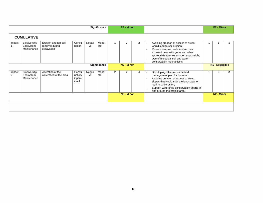
CUMULATIVE
Impact 1
Biodiversity/Ecosystem Maintenance
Erosion and top soil removal during excavation
Construction
Negative
Moderate
1 2 2 Avoiding creation of access to areas would lead to soil erosion;
Restore removed soils and recover exposed ones with grass and other appropriate species as soon as possible;
Use of biological soil and water conservation mechanisms.
1 1 1
Significance N2 - Minor N1 - Negligible
Impact 2
Biodiversity/Ecosystem Maintenance
Alteration of the watershed of the area
Construction/Operational
Negative
Moderate
2 2 4 Developing effective watershed management plan for the area;
Avoiding creation of access to steep slopes that would scar the landscape or lead to soil erosion;
Support watershed conservation efforts in and around the project area.
1 2 2
N2 - Minor N2 - Minor
17
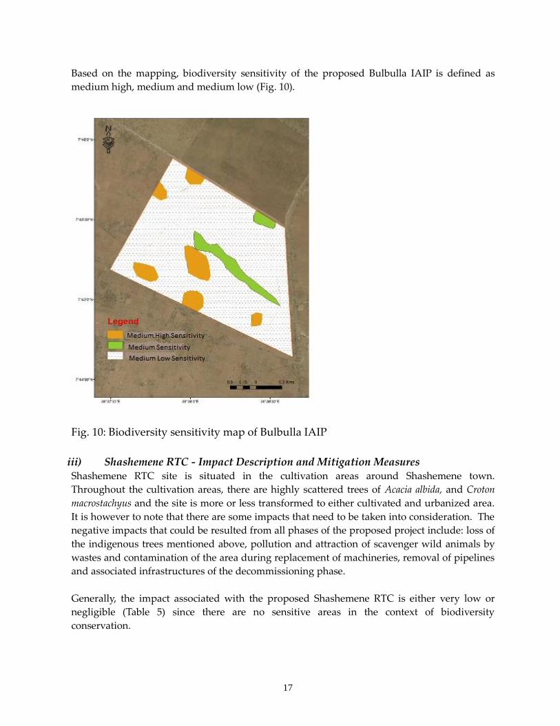
Based on the mapping, biodiversity sensitivity of the proposed Bulbulla IAIP is defined as
medium high, medium and medium low (Fig. 10).
Fig. 10: Biodiversity sensitivity map of Bulbulla IAIP
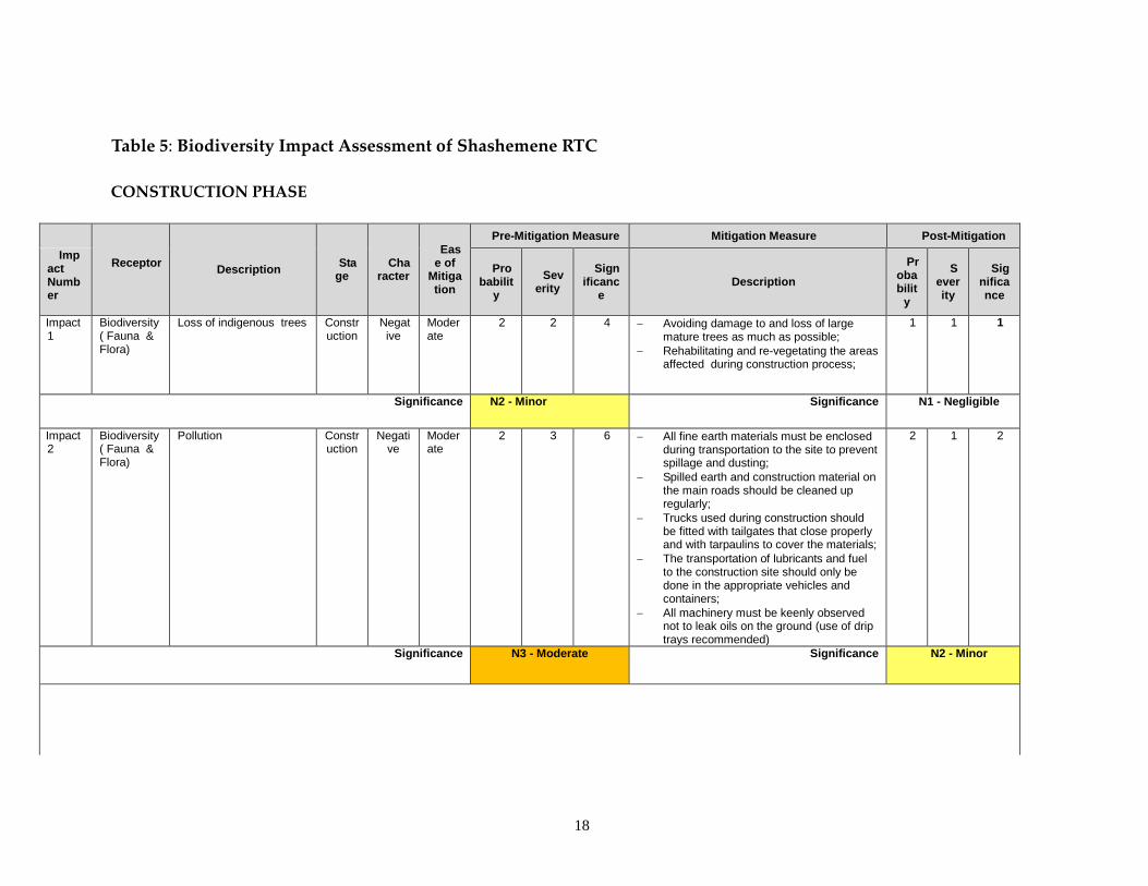
iii) Shashemene RTC - Impact Description and Mitigation Measures Shashemene RTC site is situated in the cultivation areas around Shashemene town.
Throughout the cultivation areas, there are highly scattered trees of Acacia albida, and Croton
macrostachyus and the site is more or less transformed to either cultivated and urbanized area.
It is however to note that there are some impacts that need to be taken into consideration. The
negative impacts that could be resulted from all phases of the proposed project include: loss of
the indigenous trees mentioned above, pollution and attraction of scavenger wild animals by
wastes and contamination of the area during replacement of machineries, removal of pipelines
and associated infrastructures of the decommissioning phase.
Generally, the impact associated with the proposed Shashemene RTC is either very low or
negligible (Table 5) since there are no sensitive areas in the context of biodiversity
conservation.
18
Table 5: Biodiversity Impact Assessment of Shashemene RTC
CONSTRUCTION PHASE
Receptor
Description Sta
ge Cha
racter
Ease of
Mitigation
Pre-Mitigation Measure Mitigation Measure Post-Mitigation
Impact Number
Probabilit
y
Severity
Significanc
e Description
Probabilit
y
Severity
Significance
Impact 1
Biodiversity ( Fauna & Flora)
Loss of indigenous trees Construction
Negative
Moderate
2 2 4 Avoiding damage to and loss of large mature trees as much as possible;
Rehabilitating and re-vegetating the areas affected during construction process;
1 1 1
Significance N2 - Minor Significance N1 - Negligible
Impact 2
Biodiversity ( Fauna & Flora)
Pollution Construction
Negative
Moderate
2 3 6 All fine earth materials must be enclosed during transportation to the site to prevent spillage and dusting;
Spilled earth and construction material on the main roads should be cleaned up regularly;
Trucks used during construction should be fitted with tailgates that close properly and with tarpaulins to cover the materials;
The transportation of lubricants and fuel to the construction site should only be done in the appropriate vehicles and containers;
All machinery must be keenly observed not to leak oils on the ground (use of drip trays recommended)
2 1 2
Significance N3 - Moderate Significance N2 - Minor
19
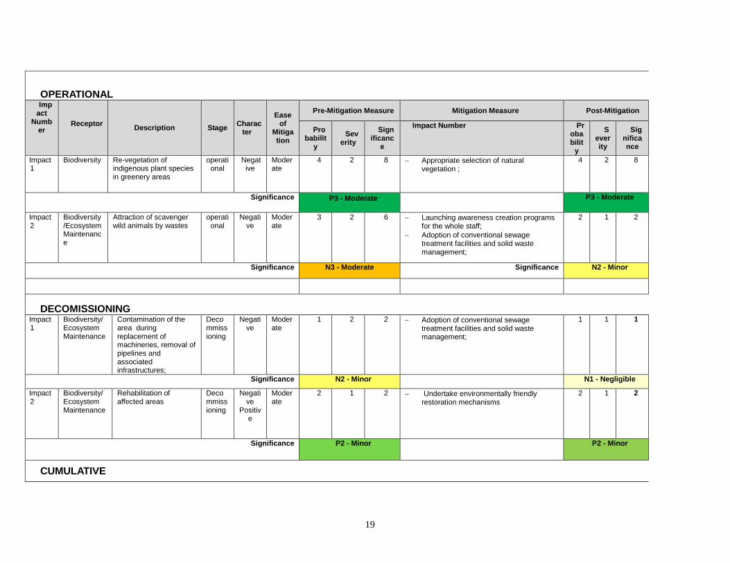
OPERATIONAL Imp
act Numb
er Receptor
Description Stage Charac
ter
Ease of
Mitigation
Pre-Mitigation Measure Mitigation Measure Post-Mitigation
Probabilit
y
Severity
Significanc
e
Impact Number Probabilit
y
Severity
Significance
Impact 1
Biodiversity Re-vegetation of indigenous plant species in greenery areas
operational
Negative
Moderate
4 2 8 Appropriate selection of natural vegetation ;
4 2 8
Significance P3 - Moderate
P3 - Moderate
Impact 2
Biodiversity/Ecosystem Maintenance
Attraction of scavenger wild animals by wastes
operational
Negative
Moderate
3 2 6 Launching awareness creation programs for the whole staff;
Adoption of conventional sewage treatment facilities and solid waste management;
2 1 2
Significance N3 - Moderate Significance N2 - Minor
DECOMISSIONING Impact 1
Biodiversity/Ecosystem Maintenance
Contamination of the area during replacement of machineries, removal of pipelines and associated infrastructures;
Decommissioning
Negative
Moderate
1 2 2 Adoption of conventional sewage treatment facilities and solid waste management;
1 1 1
Significance N2 - Minor N1 - Negligible
Impact 2
Biodiversity/Ecosystem Maintenance
Rehabilitation of affected areas
Decommissioning
Negative
Positive
Moderate
2 1 2 Undertake environmentally friendly restoration mechanisms
2 1 2
Significance P2 - Minor
P2 - Minor
CUMULATIVE
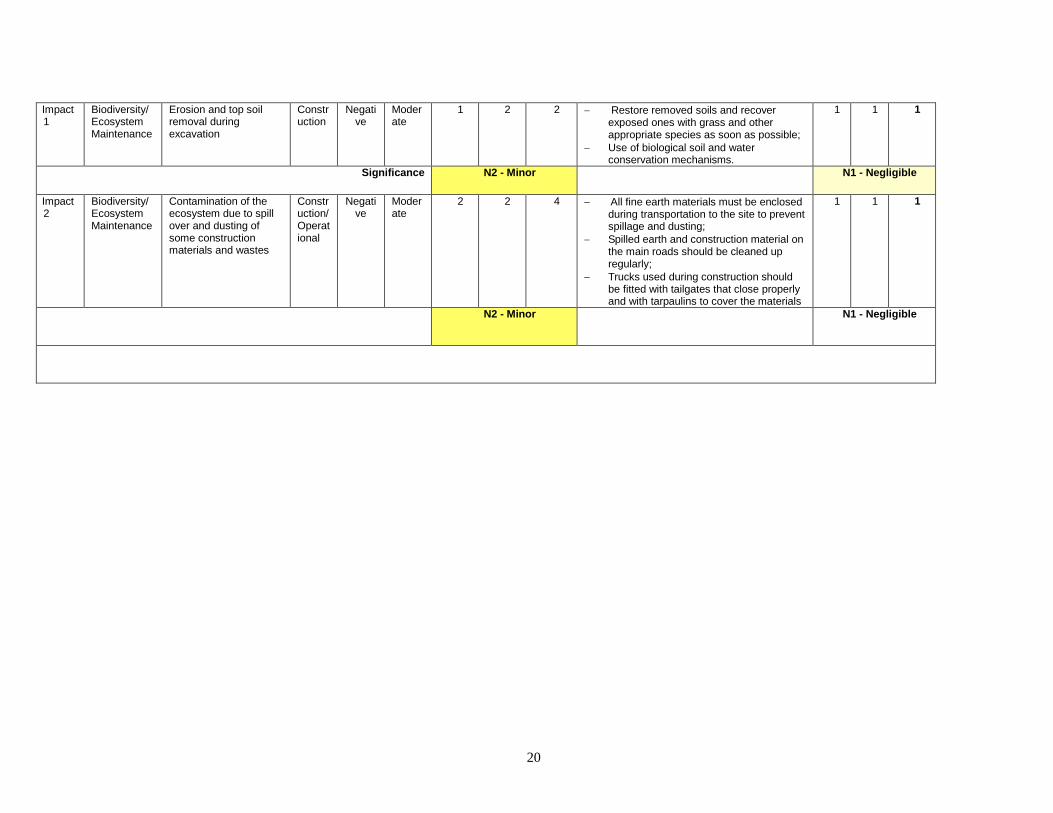
20
Impact 1
Biodiversity/Ecosystem Maintenance
Erosion and top soil removal during excavation
Construction
Negative
Moderate
1 2 2 Restore removed soils and recover exposed ones with grass and other appropriate species as soon as possible;
Use of biological soil and water conservation mechanisms.
1 1 1
Significance N2 - Minor N1 - Negligible
Impact 2
Biodiversity/Ecosystem Maintenance
Contamination of the ecosystem due to spill over and dusting of some construction materials and wastes
Construction/Operational
Negative
Moderate
2 2 4 All fine earth materials must be enclosed during transportation to the site to prevent spillage and dusting;
Spilled earth and construction material on the main roads should be cleaned up regularly;
Trucks used during construction should be fitted with tailgates that close properly and with tarpaulins to cover the materials
1 1 1
N2 - Minor N1 - Negligible
21
iv) Residual Impacts and Conclusion Generally, effective application of the aforementioned mitigation measures by the project
teams is expected to reduce the potential negative impacts associated with the Bulbulla IAIP
and Shashemene RTC projects to minor or negligible level.
Therefore, the potential impacts associated with the proposed projects can be considerably
minimized provided that the recommended mitigation measures are properly applied.
Moreover, the activities associated with the projects need to be monitored at all phases in order
to identify unpredicted impacts and take corrective measures.
22
5. REFERENCES/ Bibliography AEWA (2012). AEWA Plan of Action for Africa 2012-2017: A guide to the implementation of the AEWA
Strategic Plan 2009-2017. Adopted by the 5th Session of the Meeting of the Parties to AEWA
(MOP5), 14 - 18 May 2012, La Rochelle, France.
Bekele A., Birnie A., and Tengnäs B. (1993). Useful trees and shrubs for Ethiopia: Identification,
propagation, and management for agricultural and pastoral communities. Regional soil conservation
unit, Swedish International Developments Authority.
EEPCo 2011/12. Ethiopian Electric Power Corporation: Facts in Brief
EPA in Collaboration with MEDaC (1997). "The Environmental Policy of Ethiopia". Addis Ababa,
Ethiopia.
ERM and ESSD (2013). Report on Rift Basin Area Block 2D Seismic Survey EIA, African Oil Ethiopia,
BV.
Ethiopian Wildlife Conservation Authority (EWCA) (2014). Report on the implementation of AEWA
for the period 2012-2014 EWCA, Addis Ababa, Ethiopia. 26pp.
Ethiopian Wildlife Conservation Authority (EWCA) (2009). Assessment of the Value of the Protected
Area system of Ethiopia, “Making the Economic Case”, Addis Ababa, Ethiopia.
Ethiopian Wildlife Conservation Authority (EWCA) (2014). National Ivory Action Plan of Ethiopia.
Federal Democratic Republic of Ethiopia (FDRE) (2005). Wildlife Strategy of Ethiopia. FDRE, Addis
Ababa. 11PP.
Fekadu D., Abdi I. (2010). Ecological Assessment for the re-demarcation of Abijata Shalla lakes
National Park, EWCA. Halcrow Group Limited and Generation Integrated Rural Development (GIRD) Consultants (2009).
Rift Valley Lakes Basin (RVLB) Integrated Resources Development Master Plan Study Project.
Hillman, J.C. (1993b). Ethiopia: Compendium of wildlife conservation information. Vol.2: Information
on wildlife conservation areas. NYZS-The wildlife conservation Society- International, New York.
Institute of Biodiversity Conservation (IBC now EIB, 2012). National Biodiversity Strategy and Action
Plan (NBSAP).
Institute of Biodiversity Conservation (IBC now EIB, 2005). National Biodiversity Strategy and Action
Plan (NBSAP).
Kahumbu, P., Mbuthia, B. J. and Drori, O. (2013). Scoping study on the prosecution of wildlife related
crimes in Kenyan courts January 2008 to June 2013. Wildlife Direct, Washington DC, USA, 32pp.
Kahsay G.A. Mihret E. and Alemayehu D. (2008). Report of Wildlife Census in Aluto Open Hunting
Area, WCD,Addis Ababa.
Kahsay G.A (2017). Biological Baseline Report as part of the Environmental Impact Assessment Study
on the Proposed Geo-Thermal Power Plant and Transmission Line, Aluto.
Kingdon J. (1997). Kingdon Field Guide to Mamals of Africa. Academic Press, London.
Ministry of Water Resources (2008). Rift Valley Lakes Basin Integrated Resources Development Master
Plan Study Project, Halcrow Group Ltd. & GRID Consultants.
Negarit Gazeta (1994). A Proclamation to Provide for the Conservation, Development and Utilization
of Forests. No. 94 of 1994, No. 80, 28 March, Addis Ababa, Ethiopia.
Negarit Gazeta Proclamation No. 541/2007 on wildlife conservation.
Negarit Gazeta Wildlife Conservation Authority Establishment Proclamation No. 575/2008.
Negarit Gazeta Regulation No 163/2009 of the Council of Ministers proclaimed to determine wildlife
conservation and utilization.
Negarit Gazeta Wildlife Conservation Regulation No. 545/1974 as amended.
Nigel R., Terry S. John F. John G. and Brian S. (2009). Birds of the Horn of Africa.
Taye A. (2008). Digest of Ethiopia’s Policies, Strategies and Programs.

23
Temesgen Y. and Endaweke W. (2014). Report on Evaluation and Monitoring of Aluto Controlled
Hunting area, EWCA, Addis Ababa.
Tole, M. P. (1997) Eds. “Environmental Impact Assessment in Kenya: Theory and Practice. Proceedings
of the Environmental Impact Assessment Seminar, August 1996,” School of Environmental
Studies, Moi University .
Wood J. F. and Talling I (1965) (Cited in ERM and ESSD (2013). The chemical composition of
African lake waters. Int. Revue ges. Hydrobiol. 50:421-463.
World Bank Group (2007). Environmental, Health and Safety Guideline.
24
6. Annexes
Annex1: Checklist of the Birds of the Project Site (Bulbulla IAIP) and its Surroundings
Source: Field survey (2017)
No. Family Name English Name Scientific Name
1 Ardeidae Cattle Egret Bubulcus ibis
2 Ciconiidae Marabou Stork Leptoptilos crumeniferus
3 Accipitridae Black-shouldered Kite Elanus caeruleus
4 Hooded Vulture** Necrosyrtes monachus
5 White-backed Vulture*** Gyps africanus
6 Ruppell’s Vulture*** Gyps rueppellii
7 White-headed Vulture** Trigonoceps occipitalis
8 Bateleur* Terathopius ecaudatus
9 Gabar Goshawk Melierax gabar
10 Augur Buzzard Buteo augur
11 Long-crested Eagle Lophaetus occipitalis
12 Charadriidae Spur-winged Plover Vanellus spinosus
13 Crowned Plover Vanellus coronatus
14 Petroclididae Chestnut-bellied Sandgrouse Pterocles exustus
15 Columbidae Speckled Pigeon Columba guinea
16 Ring-necked Dove Streptopelia capicola
17 Emerald-spotted Wood Dove Turtur chalcospilos
18 Musophagidae White-bellied Go-away Bird Corythaixoides leucogaster
19 Collidae Speckled Mousebird Colius striatus
20 Blue-naped Mousebird Urocolius macrourus
21 Coraciidae Abyssinian Roller Coracias abyssinica
22 Lilac-breasted Roller Coracias caudata
23 Upupidae Hoopoe Upupa epops
24 Bucerotidae Hemprich’s Hornbill Tockus hemprichii
25 Red-billed Hornbill Tockus erythrorohynchus
26 Abyssinian Ground Hornbill Bucorvus abyssinicus
27 Red-fronted Barbet Tricholaema diademata
28 Pycnonotidae Common Bulbul Pycnonotus barbatus
29 Dicruridae Fork-tailed Drongo Dicrurus adsimilis
30 Corvidae Fan-tailed Raven Corvus rhipidurus
31 Sturnidae Greater Blue-eared Starling Lamprotornis chalybaeus
32 Ruppell’s Long-tailed Starling Lamprotornis purpuropterus
33 Superb Starling Lamprotornis superbus
34 Red-billed Oxpecker Buphagus erithrorhynchus
35 Passeridae Swainson’s Sparrow Passer swainsonii
36 Ploceidae White-headed Buffalo Weaver Dinemellia dinemelli
37 White-browed Sparrow Plocepasser mahali
25
weaver
38 Northern Masked Weaver Ploceus taeniopterus
39 Estrildidae Red-billed Fire finch Lagonosticta senegala
40 Red-cheeked Cordon-bleu Uraeginthus bengalus
*** Critically Endangered; **Endangered; *Near Threatened
Annex2: List of Larger Mammal Species of Aluto CHA
Source: Kahsay et.al, (2008) and Kahsay (2017)
No Species
Common Name
Scientific Name Conservation
Status (IUCN Red List
Category)
1 1 Greater Kudu Tragelaphus strepsiceros LC
2 Mountain Reedbuck Redunca fulvorufula chanleri LC
3 Common Bushbuck Tragelaphus scriptus LC
4 Grey Duiker Sylvicapra grimmia LC
5 Klipspringer Oreotragus oreaotragus LC
6 Abyssinian hare Lepus habessinicus LC
7 3 Anubis Baboon Papio Anubis LC
8 Vervet Monkey Cercopithecus aethiops pygerythrus LC
9 4 Common Warthog Phacochoerus africanus LC
10 5 Spotted Hyena Crocuta crocuta LC
11 6 Stripped Hyena Hyaena hyaena NT
12 6 Leopard Panthera pardus VU
13 Serval Cat Leptailurus serval LC
14 7 Caracal Felis caracal LC
15 Common Genet Genetta genetta LC
16 African Civet Civettictis civetta LC
17 Wild Cat Felis sylvestris LC
18 Honey Badger Mellivora capensis LC
19 Common Jackal Canis aureus LC
20 Bat-eared Fox Otocyon megalotis LC
21 9 Aardvark Orycteropus afer LC
22 1
0
Rock Hyrax Procavia habessinica LC
LC – Least Concern; NT – Near Threatened; VU - Vulnerable
26
Annex 3: Checklist of the Birds of Aluto Controlled Hunting Areas
Source: Kahsay et.al, (2008) and Kahsay (2017)
No. Family Name English Name Scientific Name Status/R
ange
1 Accipitridae Black-shouldered Kite Elanus caeruleus RB
2 Black Kite Milvus migrans MB/PW
3 Hooded Vulture** Necrosyrtes monachus RB
4 White-backed Vulture*** Gyps africanus RB
5 Ruppell’s Vulture*** Gyps rueppellii RB
6 Bateleur* Terathopius ecaudatus RB
7 Dark Chanting Goshawk Melierax metabates RB
8 Gabar Goshawk Melierax gabar RB
9 Augur Buzzard Buteo augur RB
10 Tawny Eagle Aquila rapax RB
11 Falconidae Common Kestrel Falco tinnunculus RB/PW
12 Lanner Falcon Falco biarmicus RB
13 Phasianidae Crested Francolin Francolinus sephaena RB
14 Clapperton’s Francolin Francolinus clappertoni RB
15 Charadriidae Spur-winged Plover Vanellus spinosus RB
16 Black-winged Plover Vanellus melanopterus RB
17 Crowned Plover Vanellus coronatus RB
18 Petroclididae Chestnut-bellied Sandgrouse Pterocles exustus RB
19 Columbidae Speckled Pigeon Columba guinea RB
20 Laughing Dove Streptopelia senegalensis RB
21 African Mourning Dove Streptopelia decipiens RB
22 Ring-necked Dove Streptopelia capicola RB
23 Red-eyed Dove Streptopelia semitorquata RB
24 Emerald-spotted Wood Dove Turtur chalcospilos RB
25 Blue-spotted Wood Dove Turtur afer MB
26 Namaqua Dove Oena capensis RB
27 Psittacidae Orange-bellied Parrot Poicephalus rufiventris RB
28 Black-winged Lovebird Agapornis taranta RB
29 Musophagidae Bare-faced Go-away Bird Corythaixoides personatus RB
30 White-bellied Go-away Bird Corythaixoides leucogaster RB
31 Caprimulgidae Mountain Nightjar Caprimulgus poliocephalus RB
32 Apodidae Little Swift Apus affinis RB
33 African White-ramped Swift Apus caffer RB
34 Collidae Speckled Mousebird Colius striatus RB
35 Blue-naped Mousebird Urocolius macrourus RB
36 Alcedinidae Striped Kingfisher Halcyol chelicuti RB
27
37 Meropidae Little Bee-eater Merops pusillus RB
38 Northern Carmine Bee-eater Merops nubicus MB
39 Coraciidae Abyssinian Roller Coracias abyssinica MB
40 Lilac-breasted Roller Coracias caudata RB
41 Phoeniculidae Black Wood Hoopoe Phoeniculus aterrimus RB
42 Upupidae Hoopoe Upupa epops RB/PW
43 Bucerotidae Hemprich’s Hornbill Tockus hemprichii RB
44 Red-billed Hornbill Tockus erythrorohynchus RB
45 Abyssinian Ground Hornbill Bucorvus abyssinicus RB
46 Lybiidae Red-fronted Tinkerbird Pogoniulus pusillus RB
47 Red-fronted Barbet Tricholaema diademata RB
48 Hirundanidae Black Saw-wing Psalidoprocne pristoptera RB
49 Red-ramped Swallow Hirundo daurica RB/PW
50 African Rock Martin Hirundo fuligula RB/P
51 Motacillidae Grey Wagtail Motacilla cinerea PW
52 African Grassland Pipit Anthus cinnamomeus RB
53 Pycnonotidae Common Bulbul Pycnonotus barbatus RB
54 Turdidae Ruppell’s Robin-chat Cossypha semirufa RB
55 Mocking Cliff Chat Thamnolaea cinnamomeiventris RB
56 Pied Wheatear Oenanthe phillipsi PW
57 Isabelline Wheatear Oenanthe isabellina PW
58 Muscicapidae Slaty Flycatcher Melaenornis chocolatinus RB
59 Platysteiridae Black-headed Batis Batis minor RB
60 Timaliidae White-rumped Babbler Turdoides leucopygius RB
61 Nectariniidae Scarlet-chested Sunbird Nectarinia senegalensis RB
62 Tacazze Sunbird Nectarinia tacazze RB
63 Malaconotidae Orange-breasted Bush Shrike Malacomotus supfureopectus RB
64 Grey-headed Bush Shrike Malacomotus blanchoti RB
65 Dicruridae Fork-tailed Drongo Dicrurus adsimilis RB
66 Corvidae Fan-tailed Raven Corvus rhipidurus RB
67 Sturnidae Red-winged Starling Onychognathus morio RB
68 Greater Blue-eared Starling Lamprotornis chalybaeus RB
69 Ruppell’s Long-tailed Starling Lamprotornis purpuropterus RB
70 Superb Starling Lamprotornis superbus RB
71 Violet-backed Starling Cinnyricinclus leucogas M
72 Red-billed Oxpecker Buphagus erithrorhynchus RB
73 Passeridae Swainson’s Sparrow Passer swainsonii R
74 Ploceidae White-headed Buffalo Weaver Dinemellia dinemelli RB
75 White-browed Sparrow
weaver
Plocepasser mahali RB
76 Northern Masked Weaver Ploceus taeniopterus R
28
77 Ruppell’s Weaver Ploceus galbula RB
78 Village Weaver Ploceus cucullatus RB
79 Chestnut Weaver Ploceus rubiginosus RB
80 Estrildidae Red-billed Fire finch Lagonosticta senegala RB
81 Red-cheeked Cordon-bleu Uraeginthus bengalus RB
82 Fringillidae Rechinow’s Seed Eater Serinus reichenowi RB
*** Critically Endangered; **Endangered; *Near Threatened
Where B- Breeding record confirmed; M - Migrant including on passage through Ethiopia; P - Breeds in Palaearctic;
R – Resident; W - Winters (non-breeding season); RB - Resident in the country and breeding records confirmed; PW
- breeds in the Palearctic and winters in the country; RB/PW - there is both a resident breeding population and a
wintering population
Annex 4: Water Birds Recorded Lake Langano
Sources: EWCA’s Waterbirds Count 2011 and 2015
No. Species Common Name Scientific Name
Range/Migrati
on Status
1 Little Grebe Tachybaptus ruficollis RB
2 Great Cormorant Phalacrocorax carbo RB
3 Long-tailed Cormorant Phalacrocorax africanus RB
4 Great White Pelican Pelicanus onocrotalus RB
5 Pink-backed Pelican Pelicanus rufescens RB
6 Cattle Egret Bubulcus ibis MB
7 Little Egret Egretta garzetta R
8 Yellow-billed Egret Mesophoyx intermedia RB
9 Great Egret Casmerodius albus R
10 Grey Heron Ardea cinerea RB/PW
11 Goliath Heron Ardea golith RB
12 Yellow-billed Stork Mycteria ibis R
13 Marabou Stork Leptoptilos crumeniferus RB
14 Glossy Ibis Plegadis falcinellus R
15 Sacred Ibis Threskiornis aethiopicus MB
16 African Spoonbill Platalea alba RB
17 Egyptian Goose Alopochen aegyptiacus RB
18 Spur-winged Goose Plectropterus gambensis R
19 Northern Pintail Anas acuta PW
20 Hottentot Teal Anas hottentota R
21 Northern Shoveler Anas clypeata PW
22 African Fish Eagle Haliaeetus vocifer RB
23 Lesser Moorhen Gallinula angulata R
24 Red-knobbed Coot Fulica cristata RB
25 Black-winged Stilt Himontopus himantopus RB/PW
26 Pied Avocet Recurvirostra avosetta PW
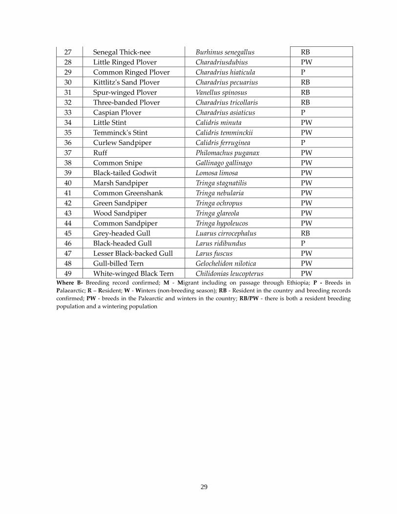
29
27 Senegal Thick-nee Burhinus senegallus RB
28 Little Ringed Plover Charadriusdubius PW
29 Common Ringed Plover Charadrius hiaticula P
30 Kittlitz's Sand Plover Charadrius pecuarius RB
31 Spur-winged Plover Vanellus spinosus RB
32 Three-banded Plover Charadrius tricollaris RB
33 Caspian Plover Charadrius asiaticus P
34 Little Stint Calidris minuta PW
35 Temminck's Stint Calidris temminckii PW
36 Curlew Sandpiper Calidris ferruginea P
37 Ruff Philomachus puganax PW
38 Common Snipe Gallinago gallinago PW
39 Black-tailed Godwit Lomosa limosa PW
40 Marsh Sandpiper Tringa stagnatilis PW
41 Common Greenshank Tringa nebularia PW
42 Green Sandpiper Tringa ochropus PW
43 Wood Sandpiper Tringa glareola PW
44 Common Sandpiper Tringa hypoleucos PW
45 Grey-headed Gull Luarus cirrocephalus RB
46 Black-headed Gull Larus ridibundus P
47 Lesser Black-backed Gull Larus fuscus PW
48 Gull-billed Tern Gelochelidon nilotica PW
49 White-winged Black Tern Chilidonias leucopterus PW Where B- Breeding record confirmed; M - Migrant including on passage through Ethiopia; P - Breeds in
Palaearctic; R – Resident; W - Winters (non-breeding season); RB - Resident in the country and breeding records
confirmed; PW - breeds in the Palearctic and winters in the country; RB/PW - there is both a resident breeding
population and a wintering population
1
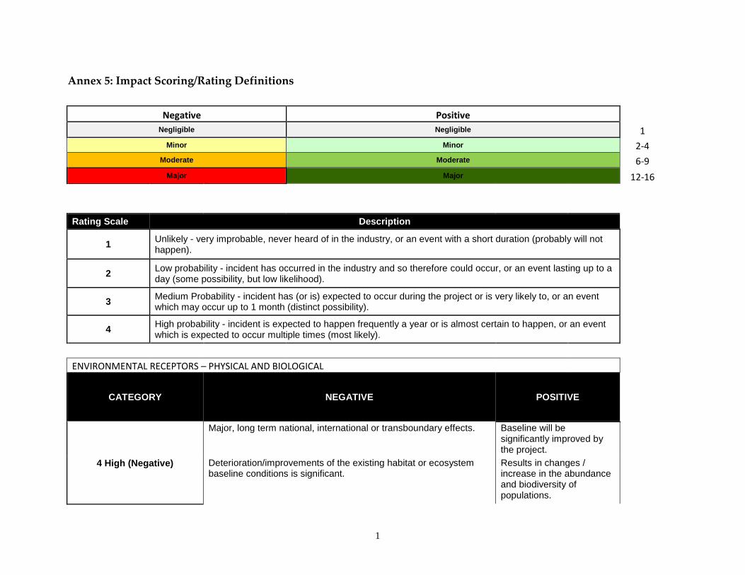
Annex 5: Impact Scoring/Rating Definitions
Negative Positive Negligible Negligible 1
Minor Minor 2-4
Moderate Moderate 6-9
Major Major 12-16
Rating Scale Description
1
Unlikely - very improbable, never heard of in the industry, or an event with a short duration (probably will not happen).
2
Low probability - incident has occurred in the industry and so therefore could occur, or an event lasting up to a day (some possibility, but low likelihood).
3
Medium Probability - incident has (or is) expected to occur during the project or is very likely to, or an event which may occur up to 1 month (distinct possibility).
4
High probability - incident is expected to happen frequently a year or is almost certain to happen, or an event which is expected to occur multiple times (most likely).
ENVIRONMENTAL RECEPTORS – PHYSICAL AND BIOLOGICAL
CATEGORY NEGATIVE POSITIVE
4 High (Negative)
Major, long term national, international or transboundary effects. Baseline will be significantly improved by the project.
Deterioration/improvements of the existing habitat or ecosystem baseline conditions is significant.
Results in changes / increase in the abundance and biodiversity of populations.
2
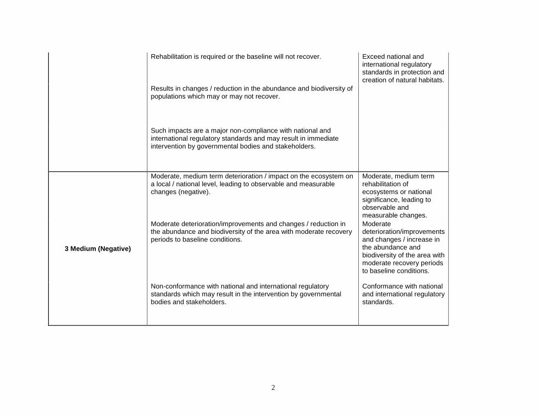
Rehabilitation is required or the baseline will not recover. Exceed national and international regulatory standards in protection and creation of natural habitats.
Results in changes / reduction in the abundance and biodiversity of populations which may or may not recover.
Such impacts are a major non-compliance with national and international regulatory standards and may result in immediate intervention by governmental bodies and stakeholders.
3 Medium (Negative)
Moderate, medium term deterioration / impact on the ecosystem on a local / national level, leading to observable and measurable changes (negative).
Moderate, medium term rehabilitation of ecosystems or national significance, leading to observable and measurable changes.
Moderate deterioration/improvements and changes / reduction in the abundance and biodiversity of the area with moderate recovery periods to baseline conditions.
Moderate deterioration/improvements and changes / increase in the abundance and biodiversity of the area with moderate recovery periods to baseline conditions.
Non-conformance with national and international regulatory standards which may result in the intervention by governmental bodies and stakeholders.
Conformance with national and international regulatory standards.
3
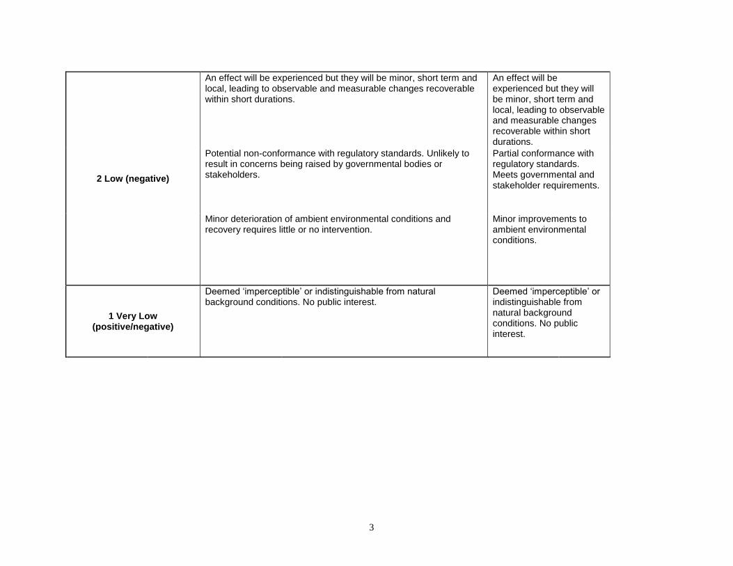
2 Low (negative)
An effect will be experienced but they will be minor, short term and local, leading to observable and measurable changes recoverable within short durations.
An effect will be experienced but they will be minor, short term and local, leading to observable and measurable changes recoverable within short durations.
Potential non-conformance with regulatory standards. Unlikely to result in concerns being raised by governmental bodies or stakeholders.
Partial conformance with regulatory standards. Meets governmental and stakeholder requirements.
Minor deterioration of ambient environmental conditions and recovery requires little or no intervention.
Minor improvements to ambient environmental conditions.
1 Very Low (positive/negative)
Deemed ‘imperceptible’ or indistinguishable from natural background conditions. No public interest.
Deemed ‘imperceptible’ or indistinguishable from natural background conditions. No public interest.
Recommended