BAOLIS, BRIDGES AND CARAVAN SARAIS ALONG
THE GRAND ANCIENT TRUNK ROAD IN N.W.F.P.
Taj Ali
1. The Ancient Grand Trunk Road: A Brief History
This study describes only a small portion of the ancient route followed by
kings, invaders, traders and merchants since remote antiquity. Roads and
communication system under a competent administration and management
play a vital role in the soci.p-economic development of a country.
When this Grand Trunk Road came into being? We do not know. Earlier study
conducted on the subject has . collected and explained many literary references about its
existence in the pre-Islamic period (1). We have scant information about the administration of
ancient routes and the roadside facilities provided for the convenience and comfort of
travellers and traders during the early Islamic period. Since early Islamic period, it remained
the foremost duty of the king to construct and maintain roads, bridges and sarais and to
provide safe travelling to every one. The earliest reference to sarai on the main routes occurs
during the reign of Muhammad Bin Tughlaq (1324-51 ). He ordered that a sarai should be
built after each stage between Delhi and his new capital Daulatabad.(2). His successor, Firoz
Shah Tughlaq (1351-87) who is styled as the builder king oflndia constructed as many as 120
hospices and inns only in Delhi. These houses were, indeed, intended for the comfort of the
travelers who were allowed free boarding and lodging for three days (3).
Sher Shah Suri surpassed all his predecessors in providing roadside facilities to the.
travelers and merchants throughout his kingdom. He also ensured safe and comfortable
travelling along the major routes. The fourth and eleventhfarman explain the administration
and management of road and communication system during his reign. In the fo� Jarman,
the administration is directed to construct and maintain roads in good condition. Moreover,
he also intended to link the capital with other parts of the kingdom and to provide safe journey
to traders and travelers.
69
In the Eleventh Jarman, the superintendents of roads are directed to maintain roads in
proper order. Trees should be planted on both sides of the roads. Sarais should be built on
th�se roads at regular intervals for the comfort of travelers. Sher Shah Suri is
said to have constructed as many as 1700 sarais along the major routes. He constructed
a sarai at a distance of every two kuroh for the maintenance of peace and for the convenience
of homeless travelers.
Each sarai provided lodging facilities both for Muslims and Hindus, and at the gate of
every sarai big jars full of water were kept for the distribution of water among Hindus as well
as Muslims. Near every sarai Muslims were settled for the entertainment of Muslim travelers
and Brahmans for the Hindus. Their duty was to provide them with cold and hot water, bed
and food and ripe grain for their horses. It was his rule that whoever came to these sarais was
supplied with provision according to his rank and grain and fodder for his cattle from
government store. Markets were established near every sarai for sale and purchase. By the
side of each sarai a village was founded and in every sarai there were built a well and a
congregational mosque of burnt brick. An imam and a muazzin were appointed in the mosque
and a custodian (shahna) and several watchmen were appointed to look after the sarai. They
were all maintained from the income of the land near the sarai. On both sides of the road,
shady fruit trees were planted, so that travelers might travel under the shade, while hot winds
blow and might also take rest and repose under the trees when they got tired by their journey.
Duri°:g their stay at a sarai, they tethered their horses under the trees. Two writers were
deputed at the gate of every sarai. Their duty was to record the particulars of every passerby
(his name and the name of his residence) who came to the sarai, and then supply him
provisions. A physician was stationed at every sarai to look after the health of the people of
the locality. Bakers were also settled in the sarais and guard posts were created in the same
places for the safety oftravelers".(4)
For the protection of the road from thieves and highway robbers, Sher Shah Suri acted
on the theory of local responsibility. Abbas Khan Sarwani records SJ;ier Shah Suri's
regulations in this context:
"For the protections and safety of the road from the molestation. of the thieves and
robbers etc, rules were framed as follows. He strictly ordered his governors that if a theft or
robbery occurred in his Mamlakat, and the culprit was not detected, whatever the thief and
70
highway robber might have robbed would have to be compensated by the muqaddam of the
place of occurrence and if it had occurred in such a place the jurisdiction of which was not
known, then the muqaddams of the surrounding villages would have arrested the local
inhabitant and compelled them to pay restitution. If after the payment of fine the muqaddams
produced the thief and robber ensure their hunting places. the rnuqaddam of the village where
the offenders lived, was liable to pay the amount taken as restitution previously from them
and the thief and robber were to be punished severely in accordance with the holy religious
law. If there was a murder case and the assassins absconded. the muqaddams were arrested in
the above mentioned process and were put to prison and given a period within which they
were to produce the murderers. If they produced the assassins or showed the place of their
residence. the muqaddams were set free and the murderers were killed. But if the muqaddams
of a village in the jurisdiction of which murder was committed. failed to this. they were put to
death".(5)
Following the policy of Sher Shah Suri, his son and successor Islam Shah Suri issued
orders that as "the sarais of Sher Shah were two miles distant from one another, one of similar
form should be built between them for the convenience of the public; that mosque and a
reservoir should be attached to them and that vessels of \Nater and of victuals. cooked or
uncooked should be always kept in readiness for the entertainment of Hindu as well as
Muslim travelers". He further ordered that the sarai which Sher Shah had built and gardens
he had laid out. should not be alienated and that no change should be made in their limits (6).
Emperor Akbar paid great attention to the construction and maintenance of sarais.
baolis and roads. Qasim Khan, his Architect and Engineer. suggested that sarais (rest houses)
should be established on the routes through out the empire so that the travellers might obtain
repose (7). Akbar issued orders that poorhouses (sarais) should be erected in the various
quarters of the capital and make them over to benevolent and generous persons so that poor
and needy of the world might have a home with out having to look for it. In a short time
orders were carried out and those without resources enjoyed the comfort of a home in a
foreign country (8). Akbar ordered the dispatch of advance parties for the improvement of
roads and construction or bridges over the rivers. On one occasion. while he was proceeding
to Kashmir. he sent Qasim Khan along v,:ith 3000 stone cutters. mountain miners and splitters
of rock and 2000 diggers to level the road (9) .On his return journey from Kashmir. Akbar
71
halted near Nain Sukh river and Qasim Khan was sent in advance to look after the bridging of
the .Indus river ( I 0). For the comfort and convenience of travelers. he (Akbar) ordered that
every kos of the way from Agra to Ajmir, a minar should be built for the comforts of
travelers. The minar should be adorned with deer-horns so that those who lost their way might
have a mark ( 11 ).
Jahangir ( 1605-1628) issued special regulations regarding highway robbery and theft.
He directed his administration that a sarai. a masjid and a well should be constructed on those
portions of road which are far away from habitation, the jagirdar of the neighborhood were to
build a sarai. a masjid and they were to dig a well to be the means of promoting cultivation
and to induce and encourage people to settle them. If these places were near to Khalisa lands,
the government official was to carry out these provisions ( 12). To encourage trade and
commerce throughout his empire, Jahangir remitted the transit duties on merchandise on all
commercial places on the way between Kabul and Hindustan which amounted to 123,00,000
dames (13). Emperor Shah Jehan (1628-58), the engineer king of India is famous for his
building activities. He embarked on grand projects of royal buildings at Lahore, Delhi &
Agra. His nobles such as Wazir Khan and Ali Mardan Khan are known for patronizing public
buildings. Construction and maintenance of roads were properly looked after. During his
march towards Qandahar, it is mentioned that Sadullah Khan crossed the Nilab with the royal
forces and prince Aurangzeb reached from Multan and also crossed the river and
accompanied his Royal Highness train (14). In this march Khalil Beg was sent in advance to
level the roads and construct bridges on their way.
Following the footstep of his father. Aurangzeb ordered that in all such places where
there are not sarais and rahats, permanent and commodious sarais should be constructed at
government cost. Each new sarai was provided with a bazar, a mosque. a well and a hamam
inside it. Moreover, the older sarais were repaired and maintained in good condition ( 15).
After the decline of the Mughal dynasty and subsequently under the Sikh government,
there was a political chaos in the region. Road and communication systen1 declined to its
lowest level due to insecurity. The roads and the roadside facilities were almost non- existent.
Sarais were abandoned and gave a deserted look. With the arrival of the British in the middle
of the I t/ 11 centur:. a revi, al of the route system took place. The British realized the
significance of an excellent communication system and it was their necessity to have a
72
network of roads in the sub-continent for the establishment of their rule. They started the
construction of metalled roads. bridges and railway lines for an easy and smooth movement of
their forces to each and every corner of their domain. The highway from Lahore to Peshawar
and Kabul was laid out in almost in the same alignment of the ancient medieval route.
The roads have remained almost the same, but the only change that occurred is in the
communication system and advanced transport facilities. Time is moving very fast and the
introduction of information technology has further improved and made easy the transaction of
trade and commerce. It is the only reason of the decline of sarais, baolis and kos-minars.
References
1. Verma, H.C., Medieval Routes to India: Baghdad to Delhi. A study of trade and militaryroutes, n.d .. Lahore.
2. Dar, S.R., Caravanserais and Related Buildings in Pakistan: Systems and Structures. In:Journal of Asian Civilisations, Vol.XXII/1, P.104-125. Islamabad, 1999. On page 107. hestates that F.A Khan has interpreted an E-shaped building to the east of the mosque atBambhore as Serai.
3. Ibid., P. 107.
4. Khan, H .. Sher Shah Suri. p. 332-33, Lahore, 1987.
5. Ibid. p.334
6. Elliot and Dow son. History of India as told by its O\Nn Historian, vol.v, p.486-87.rep.Lahore ,1976.
7. Abu! Fazal, Akbarnama. (Eng. Trans. H. Beveridge) Vol. Ill. p.559, n.d., Rep. Lahore.
8. Ibid. p.381
9. Ibid. p. 817
10. Ibid. p. 851
11. Ibid. p. 156
12. Elliot and Dowson, op.cit.Vol.VI, p.284-85.494
13. Ibid. p. 290-91
14. Elliot and Dowson. op.eit.'Vol.VII. p. 95.
15. Dar. S.R., Op.cit. P.109.
73
2. The Ancient Grand Trunk Road in the NWFP
The ancient road in the NWFP only covers a small portion of the Grand Trunk Road
between Delhi and Kabul. Prior to the arrival of the Mughals. our information about this
route is sketchy and incomplete. With the arrival of the Mughals the picture becomes a little
clear. as they have mentioned important halting stations. sarai etc. between Attack and
Peshawar. Babar and his successors have left us valuable information about their itinerary
between Attack and Peshawar. Their main halting stations were Attack (I). Sarai Bara (2),
Sarai Daulatabad (3). Bagh-i-Sardar Khan (4) and Bagh-i-Peshawar or Bagh-i-Zafar (5).
Bahar, on the second occasion in March 1519. crossed river Indus on boats which were
brought from Nilab. Next day he reached Bigram (Peshawar) and visited Gar-Khatri (6).
Akbar the great on his way to Kabul crossed Indus River several times. In 1588, he encamped
at the meeting point of the Indus and Kabul rivers. I-le left the main camp with an immense
quantity of baggage on the banks of the Indus River and entrusted that area to Qasim Khan in
order to subjugate the rebellions and to construct a bridge (on the Indus River). The standard
moved forward and stopped on the bank of Kabul River. Next he reached to Daulatabad (7).
Marching towards Kabul he stayed near Bigram and spent some time in Gor-Khatri, which is
a shrine of Jogis (8).
Jahangir is more explicit in his itinerary and says "I encamped near the fort of Attock
on the bank of river Nilab. In these days the Nilab was very full. insomuch that the bridge
consisted of eighteen boats. over which people passed with great ease and security .... I
embarked with the prince and a few attendants on a raft. and passing over the Nilab in safety,
landed on the bank of Kabul River. ... From that ground we moved. one march intervening, to
my camp near Sarai Bara. on the opposite side of river Kabul, there is a fo11 built by Zain
Khan Koka .... It is called Naushahra .... I moved to Sarai Daulatabad. (Next day) I arrived at
the garden of Sardar Khan near Peshawar. Gor-Khatri. a famous place of worship amongst
the Jogis, is in this neighborhood."' (9)
Shah .Jahan stayed in Peshawar on several occasions. In the first reference it is
recorded that on Ist Rabi-us-Sani I 056 l-I. he crossed the Ni lab River. On the 5th
, he stayed in
the building constructed by Amir-ul-Umra in the fort of Peshawar ( I 0). On another occasion.
it is stated that on the 23rd
Ramazan 10591-1. he encamped in Bagh-i-Zafar, Peshawar and on
the 26th he crossed the Indus river ( 11 ). In I 062 H when he was coming back from Kabul. he
74
stayed in Bagh-i-Peshav.-ar. On the eight Shawal, he left Peshawar and on the 11111 he
embarked on the bank of the Indus River. Due to heavy rains, the river was in high f1oods.
The boat bridge constructed on fore mentioned river by Saifullah was washed away and later
on he crossed the river at the ferry of Jalalia, where a bridge was constructed of fo11y boats
( 12).
Describing the advance of the imperial army towards Qandahar. it is mentioned that
Saadullah Khan crossed the Nilab River with the royal forces and prince Aurangzeb reached
from Multan and crossed the same river and accompanied His Royal Highness. In this
marched Khalil Beg was sent in advance to level the road and construct bridges (13).
Historical literature is full of references that confirm that this ancient route remained
almost unchanged during the succeeding centuries. Hugel in his travels reported that '·at a
little distance beyond the fort (of Attock) is the bridge of boats, formed of nineteen immense
vessels, built singularly enough. with fine carved work both fore and aft"" ( 14 ).
Even the British followed the same route and keeping in view its significance, a permanent
bridge was constructed on the Indus River near Khairabad.
Reference
1. Tuzuk-i Jahangiri (Urdu Trans. Quddusi, I. H. and S.H.D., Rashidi), Vol. II P.200- 01Lahore 1968; Elliot & Dowson, History of India as told by its own Historians, Vol. VI,P. 312ff. Rep. Lahore, 1976.
2. Bid, Op.cit.
3. Op.cit: Abu! FazL Akbarnama (Eng. Tran. H. Beveridge) Vol. III, p. 524, nd, Lahore.
4. Tuzuk-i- Jahangiri. Op.cit. Elliot and Dowson, Vol. VL Op.cit.
5. 5. Kamboh, Muhammad Salih, Shahjehannama, (Per. Trans. G. Yazdani, et. el.), Vol.II, p. 391. Vol. III. p. 79, 115.
6. Babar. Zaheer ud Din Muhammad, Babarnama (Eng. Tran. A.S. Beveridge). p. 394.Rep. Lahore. 1987.
7. Abu! Fazl. Akbarnama (Eng. Tran. H. Beveridge) Vol. Ill, pp. 523-24. nd, Lahore.
8. Ibid. Op.cit, p. 528.
9. Elliot and Dowson Op.cit, Vol. IV. p. 312-14.
10. Kamboh. Muhammad Salih, Op.cit, Vol. II. p. 391.
11. Ibid. Op.cit, Vol. Ill. P.79.
12. Ibid. Op.cit. Vol. Ill. P.115.
13. Elliot &Dowson. Op.cit, Vol VIL P.95.
14. Hugel. H.C. Travels in the Kashmir and the Panjab. P.216-17, rep. Lahore 1976.
75
3. Architectural Remains Along the Grand Trunk Road in the NWFP
The architectural remains, which flourished on the Grand Trunk Road between
Peshawar and Khairabad. can be described under the following headings.
3.1. Baolis
Water is one of the most important commodities of life and every living thing is ali,·e
due to it. It is life giving and it also cleans and purifies things. During the Muslim period.
due care was taken to provide water facilities to people and great emphasis ,,·as laid on the
construction of wells on the frequented routes. The construction of roads. bridges and wells
are considered the works of religious merit, and those who have rendered such services for the
welfare of the people. shall receive their rewards in the life after death.
In pre-Islamic India. wells and baolis have temple association. Owing to their
utilitarian character they are usually located within or on the periphery of villages and towns.
On the trade and caravan routes, they occur at regular intervals or in the immediate vicinity of
caravan sarais. The establishment of wells and Bao I is is an ancient pre-Islamic tradition ( 1 ).
In Hindu architectural canons, four types of baolis and wells of ten varieties depending
on their dimension have been mentioned. The most characteristic examples of wells. baolis
and well houses have survived in Gujrat. The elaborate well houses have not only provided a
cool retreat to the people in the hot summer but have also been the main source of water
supply (2).
During the early Islamic period. we have no information about such wells and baolis.
Some earliest step-wells are mentioned in Delhi. The first is ascribed to the reign of Sultan
Shamsuddin Iltutmish ( 1210-36) called Gandak ki Bao Ii near dargah Qutb shah. The second
example is dated in the Tughlaq period. called Ugrasan ki Baoli. Daulat Khan. a noble of
Sultan Sikandar Lodhi is believed to have constructed a baoli like structure in ·1 s 16, called
Rajon ki Bain. Such stepwell like structures were also constructed in the fort of Agra and
outside the main building complex of Fatehpur-Sikri (3 ).
The baoli architecture reached its perfection in Gujrat during the reign of Ahmed
Shahi dynasty. The most significant examples of the baolis of this period arc Bai Harir"s
Baoli at Asarwa and the baoli at Adalaj. about 17 km from Ahmedabad. The Bai Harir·s
Baoli, built in 1499 is almost an underground structure and the only portion above the ground
76
being the Kiosks one at each end of the complex. The Adalaj baoli is more elaborate than Bai
Harir' s step well. It is a complex structure and consists of several storeys, platforms, pillar
chamber and well-proportioned steps (4).
Began in the pre-Mughal India, it was in Gujrat that baoli consfruction received great
attention and became the most popular public building of matchless ai1istic workmanship.
The M ughal period marked a new era in the history of architecture of the subcontinent and
it is in this period that a stepped well usually consisted of three constituent parts:
I. A vertical shaft with arrangement of hauling up water by buckets.
2. Starting from the ground surface a flight of steps or stepped corridor leads down several
steps to the water level.
3. The entrance in the shape of an arch or an open square pavilion.
The open pavilion is usually a simple structure of square shape raised on a high platform
with a flight of steps on three sides. while the fourth side leads down to the well. In cases
where the square pavilion is not present, several steps give access to the stepped corridor
descending to the water level. In some cases, a simple archway marks the entrance to the
stepped corridor or by lateral gate-towers leaving the space between them as an entrance (5).
The following wells and baolis are located along the ancient grand trunk road between
Peshawar and Khairabad and once contained sweet cold water and had quenched the thirst of
many soldiers, traders and merchants on their way either to Kabul or Punjab.
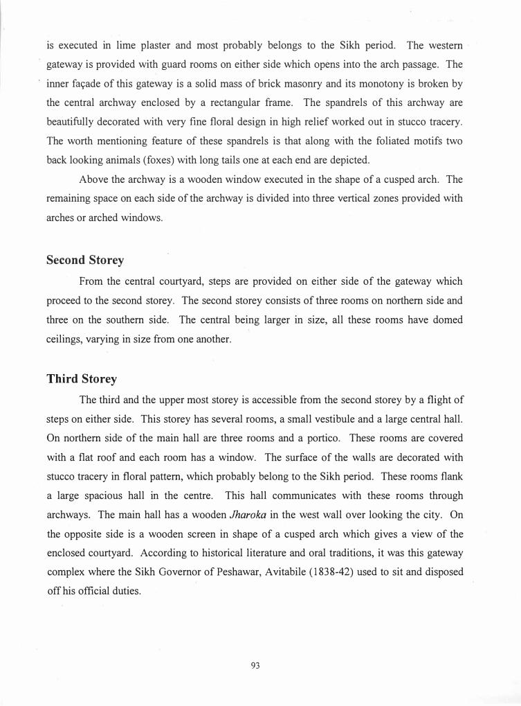
3.1.1. Chamkani Baoli
This baoli stands in the middle of cultivated lands to the north of Kichauri road near
Daman village. It is constructed of small Mughal style bricks and consists of an almost
square pavilion. a flight of steps descending to the water level and the circular shaft of the
well.
The square chamber is provided with an arched entrance on each side and each fa9ade
differs in architectural details. The eastern side is slightly longer than the other sides and
projects beyond the alignment of the square chamber. The arched opening on the east side is
1.30 m in width and is enclosed by another cusped arch worked out in lime plaster. On each
side of the main archway is a rectangular paneL which contains two decorative arches, placed
one above the other.
77
The northern fa9ade has an arched entrance with a tall arched panel on each side. The
western arched panel accommodates steps executed in the thickness of the wall masonry
leading to the upper storey. The remaining two sides, i.e., south and west is similar in
elevation and are provided with arched openings. A stringcourse worked out in lime plaster
runs below the parapet of the square chamber.
Internally, the square chamber hers a domical ceiling suppo11ed on corbelled
pendentives. The lower square pavilion is surmounted by a second storey, which is actually
its replica in small size. A low flat dome covers the upper storey with an inverted flower at
the crowning. The square chamber was lime plastered both externally and internally with an
additional coat of paccct qalai (glazed plaster).
The western arclrn:ay of the square chamber opens into a flight of steps descending
down to the water level. These steps worked out in brick masonry. are well proportioned in
their execution. An arch marks the end of the steps. which demarcate the outline of the
circular shaft of the well.
Neither historical nor inscriptional evidence is available to assign a precise date to this
structure. However, its architectural style and decoration suggest a date contemporary with
the adjacent bridge constructed over the Bara River.
3.1.2. Baoli in Tarnab
About five Kilometers east of Chamkani is the Agricultural Research farm, Tarnab.
Mr. Zakirullah. one of ex-graduates in Archaeology. who hails from the same village.
informed me that there used to be a baoli also in his village. Presently. it is completely filled
in and it is difficult to know its actual plan and other architectural details. Keeping in view
the local style of construction, we can assume that its composition did not differ from the
other baolis in the area.
3.1.3. The Baoli at Azakhel
This baoli lies to the south of the main high way at the back of Allied FlourMills. It is
constructed in hr11.." masonry laid in lime mortar. The bricks are small in size and are similar
to the bricks used in other buildings of the Mughal period. From the e:-.:isting remains it seems
that it was identical to the Baoli in Chamkani in layout and construction.
78
It was composed of three parts:
a) a square pavilion on the east side,
b) a flight of steps partly covered by a vault descending to the water level and
c) the circular shaft of the well.
What remains of the square pavilion now is only the arched entrance, which gives access
to the flight of steps. Most probably the square pavilion was provided with arched entrance
on all sides and had a domed ceiling. The surviving arched entrance on the western side is
cusped in outline and directly opens towards the stepped corridors. The total length of the
corridor is 19 m. and measures 4.00 m. in width excluding the walls. Presently, 15 m. of the
corridor is open to sky and the remaining 4-m. has a vaulted ceiling. The steps, which once
provided access to the water level below, are destroyed and submerged in water. Moreover,
there are two depressions in the walls of the corridor opposite to each other. Most probably
these were designed in the shape of arched niches and were approximately 1.40 m. in width.
The circular shaft of the well, presently filled with water upto its brims is 5 m. in diameter
excluding the walls.
As a whole, the baoli is in a very bad state of preservation. The provincial Directorate of
Archaeology and Museums in this direction has made a beginning. The archway has been
strengthened and consolidated to a great extent and the work should be continued to
strengthen the structure from further decay. The rise in water table and salinity of the soil are
major threats to the existence of the monument. Effective measures must be taken to arrest its
further decay and to prolong its life with regular maintenance and look after.
2.1.4 Well in Akora Khattak
This ancient well was located to the left of the grand Trunk road. In 1993, it was
recorded and documented but now it is completely filled and even its location is not easily
traceable due to the rapid construction along the main road.
It was constructed of rubble stone masonry laid in lime mortar. The circular shaft of
the well had three concentric rings on the top and the entire structure was covered with a thick
layer of lime plaster. A drain in the shape of a cascade was provided at the northeastern
corner of the well that suggests that water was drawn from it also by a "Persian wheel".
79
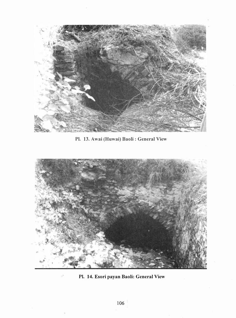
2.1.5 Baoli at Huwai (Awai)
This baoli lies about 6 Km south west of Akora Khattak. It is constructed of stones
laid in lime mortar. The depression marking the circular outline of its shaft and an exposed
dilapidated portion of the steps reveal its composition. The available evidence suggests that
the builder had taken advantage of the natural springs and a baoli was constructed. Although
the shaft of well is completely filled and wild growth has covered it but water is still gushing
out from here. The exposed stepped corridor is 3 meter in v;idth including the walls. The
exposed wall surface suggests that it was once covered with lime plaster.
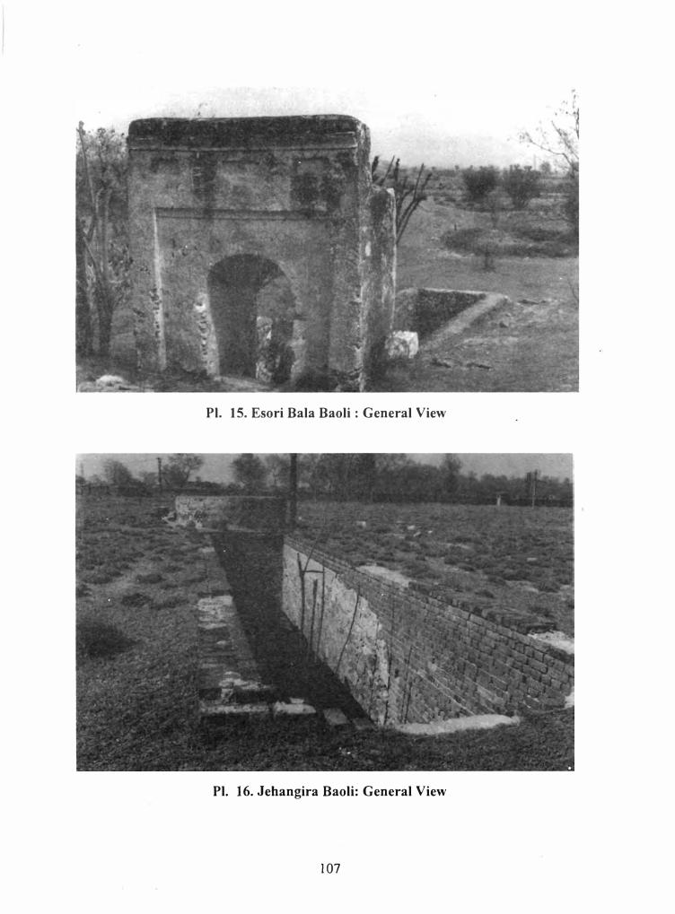
2.1.6 Baoli at Esori Bala near Akora Khattak
It is situated about 6 Km south of Esori Payar� from the G.T. road. It is the only baoli.
which is complete in all respects and in the best state of preservation. River pebbles and
irregular blocks of stone laid in lime mortar have been used in its construction. The baoli is
constructed in three parts:
a. Shaft of the well.
b. Flight of steps covered by a vaulted passage.
c. An arched entrance.
The shaft of the well is square 111 shape at the bottom and circular above, and has a
diameter of about 5.20 m. including the walls. It is full of crystal clear water and its depth is
14 m. from the surrounding ground level. A flight of 60 steps covered by a vaulted corridor
supported on arches lead down to the water level. The water level has arisen and has
submerged 8 steps. A beautifully constructed arch way give access to the covered corridor.
The arch way is suppo11ed on two pillars and is 1.25 m. in width. The steps are well placed
and proportionally balanced . Each step constructed of rectangular stone slabs is 0.40 m. wide
and 0.35 111. high.
The total length of the passage is more than 28 m., half of which is open to sky. and the
remaining portion is covered by a vaulted ceiling. The arched entrance is lime plastered at a
later date. According to local information, the baoli was constructed by Ghulam Farooq
Khan, an elite of the area in the first decade of the present century. Recently the Provincial
Directorate of Archaeology and Museums has protected this specimen of our cultural heritage
and enclosed it by a barbed wire fencing with cement concrete posts to ensure its safeguard
80
from human hazards. However, the fencing and the concrete posts deeply embedded in the
ground have recently been dislodged and demolished which reflect unawareness of the
general public towards our glorious cultural property.
3.1.7. Baoli at Esori Payan
The baoli at Esori Payan near Akora Khattak is located on Peshawar-Islamabad
highway immediately to the east of the Pakistan State Oil filling station. It consists of two
parts: a) circular shaft of the well and b) a flight of steps that descends to the water level.
The baoli is constructed of rubble masonry from river pebbles laid in lime mortar. The
covered corridor including the walls is 3.20 m. wide and about 8.00 m. long. The circular
shaft of the baoli (5 m. according to the measurement of the circular depression) is completely
filled in with debris and presently a depression, marking its circular outline is only visible.
The vaulted corridor covering the steps is constructed on arches and now only the arch and
the broken steps exist. It is in a very dilapidated condition. Following the visible structure. its
complete layout is needed to be traced out and properly exposed. After exposure the missing
portion should be restored and the whole structure be consolidated in its original plan.
3.1.8 Baoli at Adamzai
This baoli, which has now completely disappeared from the ground surface due to
human neglect, was once located a few meters short of Nowshera glass sheet factory. The
only portion, standing a few years ago, was its entrance. This gateway was constructed of
bricks laid in lime mortar. After the establishment of the Provincial Directorate of
Archaeology and Museums. Govt. ofNWFP, initial clearing of the baoli was under-taken that
resulted in the exposure of steps leading down to the water level. From the exposed structural
remains, it was concluded that it consisted of the usual three pai1s: (a) circular well. (b) flight
of steps and (c) the entrance. Today nothing exists except a circular depression marking the
outline of the well and some traces of the wall foundations.
81
3.1.9 Baoli inside F.P. Textile mills, Jahangira
The baoli is situated in the premises of Frontier Punjab Textile Mills, Jahangira on the
main G.T. road. It is complete and constructed of river pebbles of irregular shapes and sizes
laid in lime mortar. It consists of two parts: (a) a circular shafts of the well and (b) an open
flight of steps descending down to the water level. The F.P. Textile Mill authorities have
carried out some restoration work in brick masonry, which has distorted its historical
significance. The repair work executed in bricks should be removed and replaced with stone
masonry to set it in its true historical perspective. When the mill was in running condition, an
electric water pump was installed here to provide drinking water to the complex. Owing to
the growth of wild plants, the steps are badly damaged. The authorities should take
immediate measures to arrest its further deterioration.
3.1.10. Well in Khairabad
Two wells relating to old times have been recorded. The first well lies a few meters to
the left of the road in the main bazar. It is constructed of stone blocks of various shapes and
sizes laid in lime mortar. It has a circular shaft having a diameter of 3.30 meter. The
thickness of the wall is about one meter and is filled with debris of all kind. The existing
depth of the well is more than 13 meters.
There is another circular well constructed of stone blocks to the west of the town on
the ancient route. It has a diameter of 2.20 meters excluding the wall which is 1.60 meters
thick. Presently it is five meters deep.
References
1. Jain - Neubauer, J., The Stepwells of Gujarat. In: Art Historical Perspective,
p.3,Delhi, 1981
2. Nath, R., Account of a Typical Mughal stepwell (Baoli) and a Well -House(
Kupagar), In: Some Aspects of Mughal Architecture,p.22, Delhi, 1976
3. Jain - Neubauer, J. op.cit., p. XIII
4. Nath, R., op.cit., p.23, Brown,P., Indian Architecture (The Islamic Period), p. 60
5. Jain_ Neubauer, J., op. Cit. P.2. Nath, R., op.cit. p.22-23
82
3.2. Bridges and River Crossings
Since the introduction of trade and communication system, nvers were the mam
obstacles in the free and smooth movement of rulers, traders and invaders. During the
medieval period rivers were usually crossed at fords, ferries or by boat bridges. At such
places, large and small settlements had developed where the sailors used to lead the people
across the river.
During the medieval period we have frequent references to the construction of bridges
and river crossings. We are informed that, Alauddin Khilji, after the occupation of Chitor in
1303, constructed a bridge over the Gambini River (1). Firoz Shah Tughlaq is said to hc;ive
constructed about 150 bridges (2).
During the Mughal period, we have frequent references to boat-bridges. Bahar crossed the
Indus River with the help of boats. He issued orders that boats should be brought for crossing
the Indus River. So, six boats were made available there for the purpose (3). Similarly, Akbar
crossed the Indus River on boat-bridges on several occasions (4).
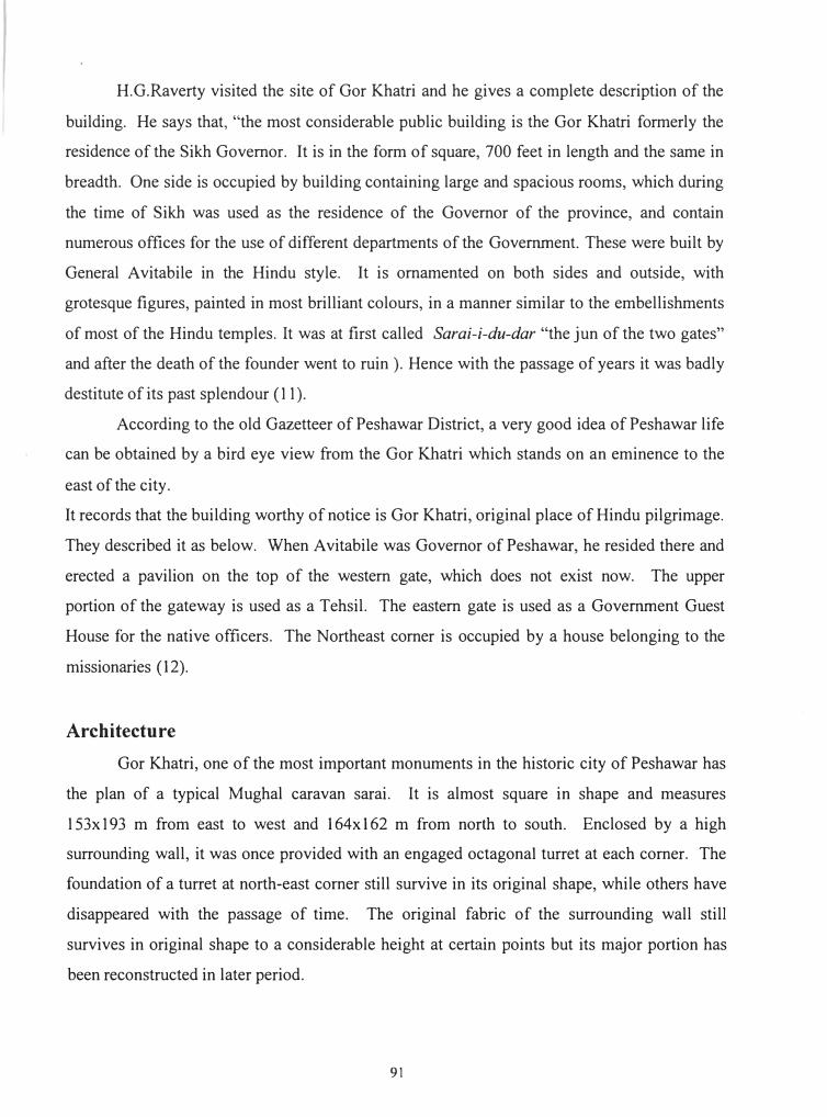
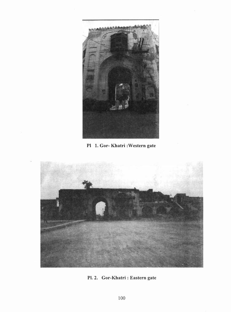
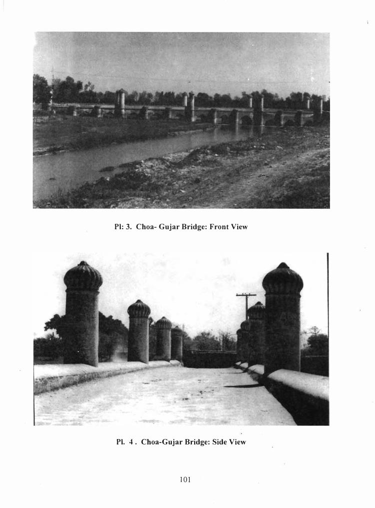
3.2.1. The so called Sethi Bridge
The so called Sethi bridge at Chua Gujar, a marvelous and unique example of trade
and travel architecture is constructed on Bara river about five kilometers east of Peshawar
city. The bridge is associated with the Sethis, a noble and trading family of Peshawar City
who had enjoyed great commercial contacts with Central Asia and Afghanistan before the
British domination. They built beautiful luxurious villas in the city as seen at Mahallah
Sethian, which forms one of the main centers of attraction for tourists.
The bridge is built of small size Mughal style bricks laid in lime mortar. It is 7 .10
meters in width and covers a span of 74.20 meters excluding the stays. The body of the bridge
consists of four visual composite segments and each segment is provided with three arched
passages raised on solid and massive p1ers. The most impressive and dominative feature of the
bridge is its cylindrical columns. Five tall, slightly tapering, columns topped by low ribbed
cupolas are provided on each side of the bridge that rise above its level. Each column is about
14.10 meters high and alternate with two identical smaller columns, which terminate at the
level of the bridge. A string course running on both the sides marks the floor of the bridge and
the parapet measuring about one meter in height is raised on it. These magnificent and
83
majestic columns are constructed as integral part of the bridge and add not only strength and
suppo11 to the bridge but also enhance its beauty and elegance. The entire bridge was covered
with thick lime pilaster and was further strengthened with a thick layer of glazed plaster.
According to local tradition the bridge was built by the Sethi family. The Sethis had
spiritual relation with Hazrat Mian Umar Sahib of Chamkani, a great Sufi of his age. During
the Sikh destruction and plunder of Peshawar city, the Sethis migrated to Chamkani and took
refuge with the renowned saint. They held Mian Sahib in deep reverence and great high
esteem.
It seems likely that the bridge was built during the Mughal period but later on the
Sethis repaired it in the late Mughal time. However, no solid evidence is available about the
actual date of its construction.
A rectangular marble slab (90 x 45 cm) with carved inscription is fixed in the first
column on the north western side. The slab is badly damaged and the entire inscription 1s
flaked off except a few linear designs at corners.
Another inscription now preserved in the Peshawar museum is believed to have been
brought from a bridge over Bara River (5). It records the construction of a bridge during the
reign of Shah Jehan. According to the chronogram of the inscription, the bridge was
constructed in 1629 AD. The inscription also mentions three other names: Lashkar Khan, the
Mughal governor of Peshawar, Abdul Latif, the founder of the bridge, and Daud, the architect.
Whether this inscription helongs to the same bridge described above or to another on the same
river is difficult to say. However, according to our investigations and survey of the
surrounding areas, we were unable to trace even the foundation of any other bridge and the
local traditions are also silent about some other bridge on the Bara River. If the inscription in
the Peshawar museum belongs to the so called Sethi bridge, then it should not be ascribed to
the Sethis but to the period of Emperor Shah Jahan. The bridge not only represents the solitary
example of trade and travel architecture in N.W.F.P. but also in Pakistan. The bridge has
survived the turbulent f1oods and other natural hazards and still majestically stands on the
Bara River and reflects the competency and engineering skill of the grand Mughal period.
84
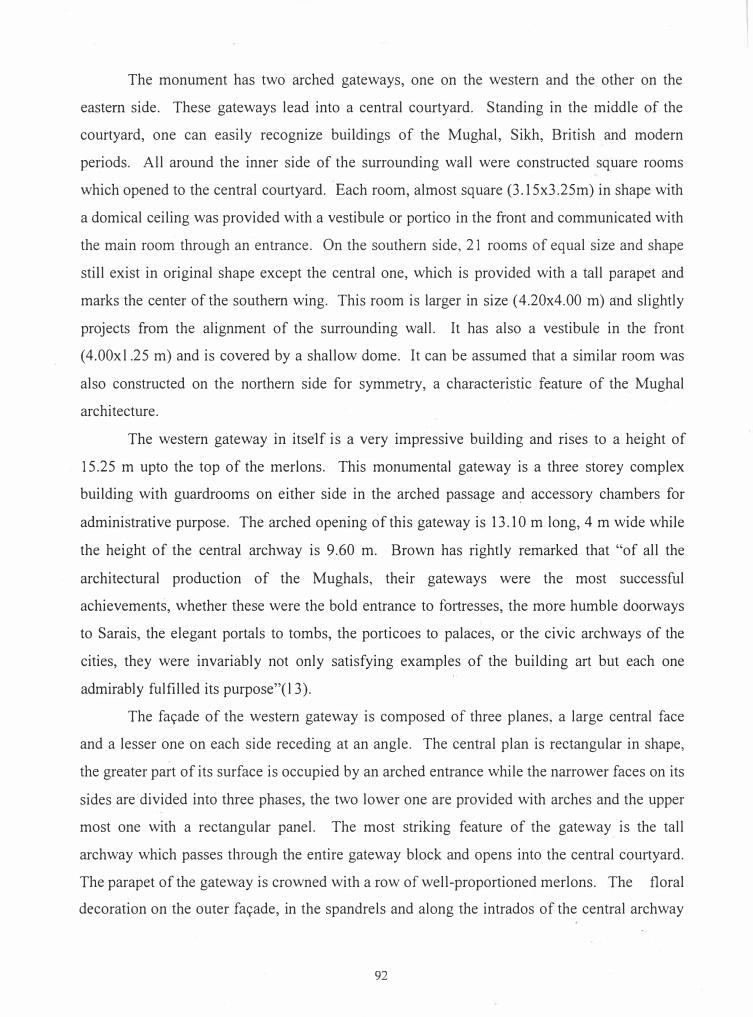
3.2.2. The Bridge at Chamkani link Road
This bridge also constructed over the Bara River can be approached from the G.T. Road and
is located at a distance of 200 m towards Chamkani. It is constructed on a single massive arch
of small size bricks with supporting stays which gently curve down in either side. The
parapet of the bridge is marked by a low wall and below it runs a moulding worked out in pre
shaped bricks. On either side the curve of the arch is decorated with a freize of acanthus
leaves executed in brick masonry and the spandrels are provided with embossed sun-flower
motifs. The solidity and compactness of the bridge can be judged from the fact that it still
sustains the load of modern heavy traffic passing over it and the turbulent tides of the Bara
River passing through it. This unique and marvelous example of bridge architecture is
believed to be constructed by the Sethi family. However, its architecture and decoration
suggest a date in the post-Mughal period, most probably the Durrani dynasty.
3.2.3 Pillars of the Boat-bridge
Several tall and massive stone pillars constructed in a line remind us the site of the
ancient boat bridge. Several wooden boat/rafts were fastened together by means of strong
ropes connecting west bank with the Kabuli gate of the Attock fort.
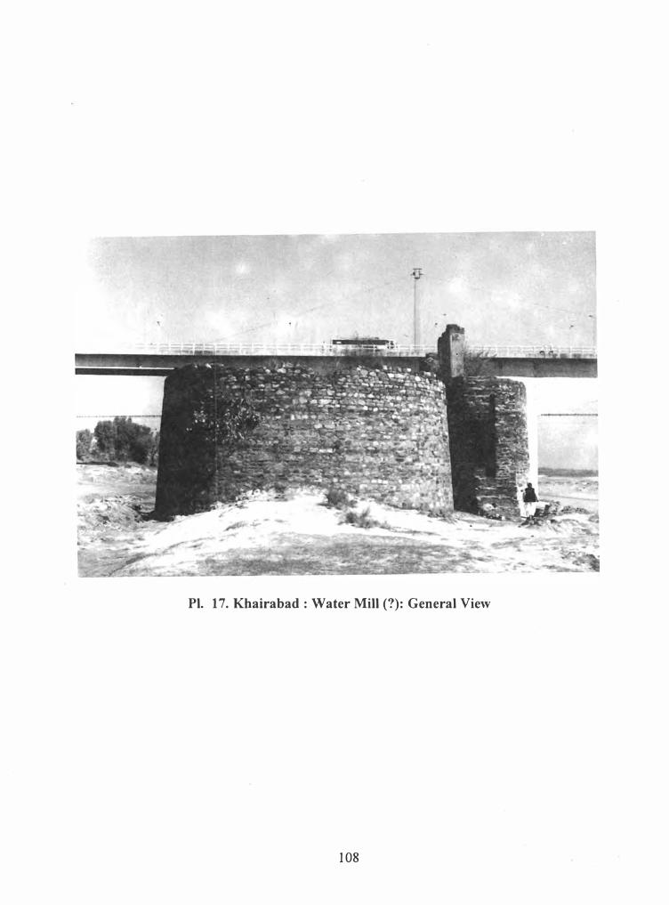
Water flour mill or watch tower (?). Immediately to the south of the new Khairabad
bridge on the Indus river stand two huge massive circular towers. Both these structures are
raised on solid rocky formation and are erected from stone blocks of various shapes laid in
lime mortar. The eastern one is 34 meter in circumference and is provided with a flight of
fourteen steps from the south side. Each step is 1.85 m in length and .30m in width. Some
later additions have almost changed its circular outline. A stone wall of a later period has
been added to it which has incorporated almost the steps except the first five. On the top,
fragmentary walls constructed in large bricks still survive. The size of the brick used is
31 x 15x6crn. Also one can see the basis of four pillars on the solid walls at the top, which
suggest that a second story was also added. On the west side, an arched opening was
provided, which seems to have been filled at a later stage.
The western tower is 42 m in circumference and has an attached wall about 4.60 in
length on the north side. In between these two towers, there is an open space of l .OOm. in the
85
shape of an aqueduct. A similar aqueduct is provided to the east of the eastern tower. A
complex of ruined structures is scattered far and wide to the west of these towers. No
concrete evidence historical or archaeological is available to explain and define these towers
satisfactorily. It appears that these structures were used for grinding corn/cereals and the later
addition suggest that these were used as watch towers for the smooth running of trade caravan
across the river.
References
1. Brown,P .; Indian Architecture (The Islamic period) p.19 ,n.d.Bombay
2. Verma,H.C., Medieval routes to India, Baghdad to Delhi,p.193, Lahore .n.d.
3. Babar Zaheeruddin, Tuzuki Babari (Eng. trans. A.S. Beveridge), p. 392, Rep. Lahore,
1987. Dar,S.R., op.cit. On p.116, he records that a good number of them (bridges) still
survive in different parts of the country but mentions their location.
4. Abu! Fazl, Akbarnama (Eng. trans. H. Beveridge), Vol. III, p. 545, 867, 523-24, ·
851,nd, Lahore.
5. Wasiuddin. A Persian Inscription in Peshawar City. In: Archaeological Survey of
India (Annual Report) p. 201-204, Delhi, 1908-09. Shakur, M.A, A Handbook to the
Inscription Gallery in the Peshawar Museum, p. 34-37, Peshawar, 1946.
86
3.3 The Ancient Mosque
Standing in the middle of green fields and fruit gardens and in the immediate
neighborhood of the so-called Sethi Bridge, are the remains of an ancient masjid. The history
is silent about this masjid. This small structure is constructed of small size Mughal bricks laid
in lime mortar. Other buildings in the immediate surroundings of this masjid have vanished
with the passage of time. The courtyard of the masjid has disappeared since long and the only
portion that still survives to the height 2.60m is the prayer chamber which is precariously
dilapidated. It is rectangular in outline and measures 8.20x5.0 meters externally. The prayer
chamber was covered by three domes, the central one, larger in size, is raised on high
octagonal drum. The drum is provided with arched windows on the eastern and western
octagonal sides for cross ventilation. The central dome is flanked by two smaller low domes,
one on each side. The crown of the dome was once adorned with a finial embedded in an
inverted flower.
The fac;ade of the prayer chamber is pierced with three arched entrances and two more
archways, one each on the shorter, side also gives access to the interior of the prayer chamber.
The central archway is larger in size than the side arched openings. Between the main and
side arched ways is a decorative niche executed in the wall masonry. The wall surface above
the side arched ways is parceled out into square and rectangular panels. On the western side, a
prominent projection is visible which marks the back of the mehrab. On its either sides are
provided two waterchutes to throw off rainwater from the roof. Adjacent to these waterchutes,
the back wall also carries two decorative arched niches wrought in the wall masonry.
Internally the prayer chamber is rectangular in outline (7 x 3 m) and composed of
three parts. The central square bay is provided with a mehrab ( 1 .20 meter wide), which is
flanked by small arched niches on either sides definitely for keeping the holy Quran and the
oil lamp. The central square chamber is converted into an octagon by means of arched
squinches, which rests on a prominent cornice worked out in brick masonry. The side
chambers are provided with comer pendentives which support the smaller low dome above.
Both externally and internally, the masjid was lime plastered and a final layer of
glazed plaster was also applied which have not survived the vicissitudes of time. Most
probabl1 the plaster surface was further decorated with frescos and other geometric
decoration according to the taste of the time.
87
No historical or inscriptional evidence is available to assign a precise date to this
masjid. Taking into account and consideration the style of construction of this masjid and its
comparison with related examples in the area, we can date this masjid contemporary with the
so called Sethi Bridge on the Bara River. If however, immediate steps are not taken for its
repairs and conservation, the masjid is feared to fall down, and this piece of sacred
architecture will sink into oblivion forever.
3.4 Caravan Sarais
During the medieval period, sarais were built at regular intervals along the main trade
route and effective measures were taken to guarantee safe journey for traders and travellers.
These sarais were great centres of cultural, social and commercial importance, where traders
and travellers used to exchange goods and ideas. They were intended not only for the use of
ordinary trade caravans but also served as halting stations for the travellers and were even
used by imperial rulers. Most probably they also served the purpose of post stations (1 ).
Merchants, traders and travellers, all needed places for rest and also protection from
robbery and bad weather both in the cities as well as in the inhospitable areas of a certain
region. This necessity led to the construction of caravan sarais along the major trade routes as
well as in the cities, where a trader was safe at night, basic facilities of food and fodder for
him and his animals were provided and also offered shopping facilities of daily necessities
and for the onward journey (2). lbn Battuta who travelled on the main road connecting Egypt
with Palestine and Syria stayed not in colleges or convents as was the custom in north Africa,
but in caravan sarais. At each of these stations between Cairo and Gaza there is a hostelry
which they call a Khan, where the travellers alight with their beasts, and outside each Khan_is
a public watering place and a shop at which they may buy what they require for themselves
and their beasts (3). This statement clearly marks the main features and functions of the
classic Islamic caravan sarais. Almost every caravan sarai is either square or rectangular in
outline with a massive surrounding wall and a single entrance wide enough to permit large or
heavy laden beasts such as camels to enter. The central courtyard is always open to the sky
and along the inner side of the enclosure wall are built a number of rooms to accommodate
merchants and their servants, animals and merchandise. Some of the caravan sarais were
provided with mosques and bath establishments (hammam). From the earliest period fodder
88
for the animals and the stables were separate from the lodgdings for the travellers and traders.
Later and larger caravan sarais had special rooms or suites in the entrance block for important
guests, and a resident staff of caretakers was permanently housed in the small rooms in the
portal block (4).
In Pakistan many caravan sarais still exist on the medieval trade routes in varying state of
preservation (5). Some of them are in a good condition, others are in ruin and reveal only their
ground plan, many more have been either completely removed from the earth surface and
some of them have retained their antiquity in the shape of modern towns. Natural calamities
and human neglect have accelerated their destruction. Modern communication system, large
scale market facilities and expansion of towns and cities have put an end to trade and travel
architecture.
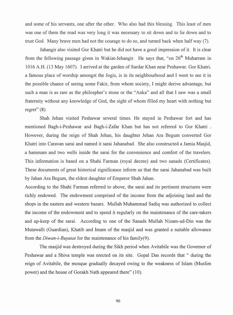
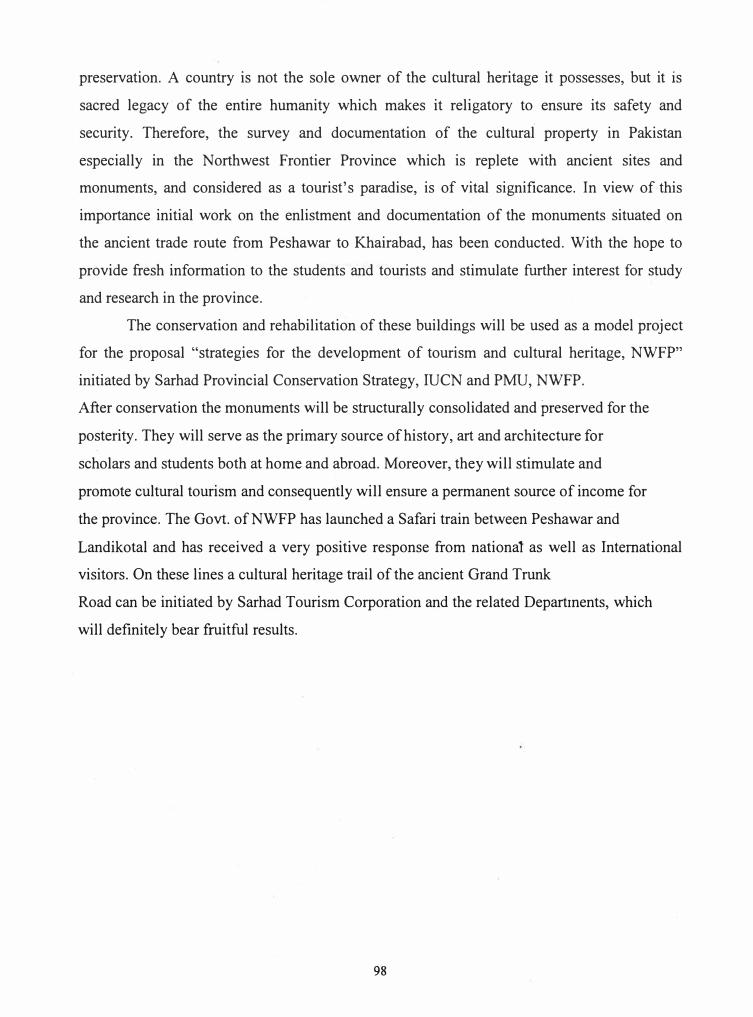
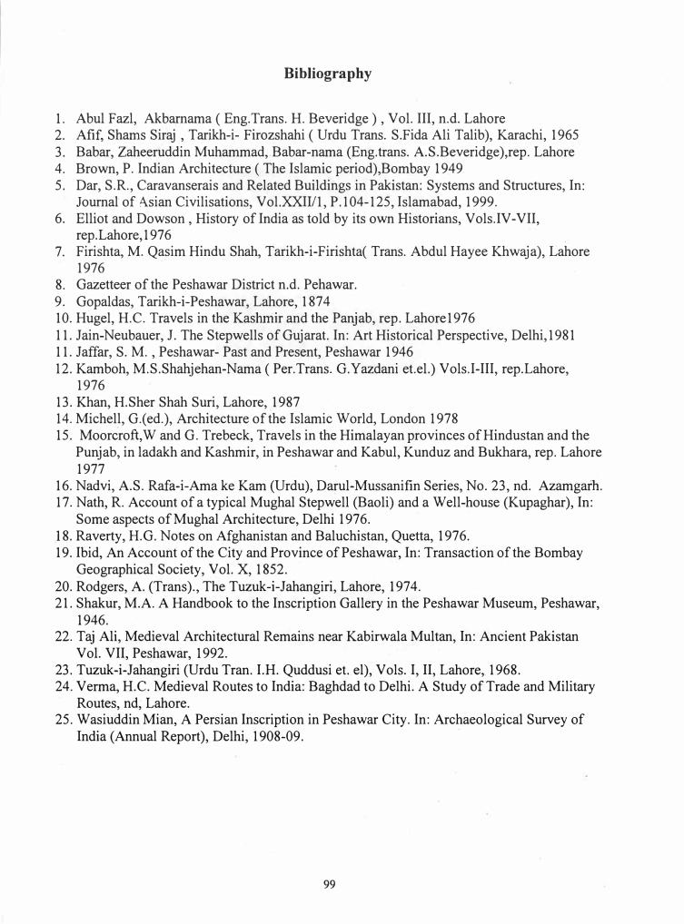
3.4.1. Gor Khatri
Historical Background
Gor Khatri, a typical Mughal sarai is one of the most important monuments of
Peshawar. It can be approached either from Chowkyadgar via Ghantaghar or from the
Hashtnagari gate. The earliest reference to Gor Khatri occurs in Babarnama, the
autobiography of Zaheeruddin Muhammad Babar, the founder of the Mughal dynasty. Babar
writes : "Next Morning ,we reached Bigram and went to see Gor Khatri. This is a smallish
abode after a fashion of a hermitage (Sauma 'at) rather confined and dark. After entering the
door and going down a few steps, one must lie full length to get beyond. There is no getting in
with out a lamp. All around the building there is an enormous quantity of human hair ( of the
head and beard which men have shaved off) there. There is a great many retreats (hujra) near
Gor Khatri like those of a rest house or a college." (6).
The description of Babar is confirmed by Abu Fazal, the court historian of Akbar who
too had the opportunity to visit the site personally in company with Emperor Akbar. He states
that: "on the 14111 July 1581, he stayed near Bigram. He spent some time in Gor Khatri �hich
is a shrine of the jogis. There is a great cave in this place. Babblers say that no one knows
how deep it is. In the midst of the cave is the way to the secret chamber of the saint of old
times. On account of the difficulty and darkness and its tortuousness, one cannot get there.
As it was the prayer spot of the great one of God, he entered it alone by the light of wisdom,
89
and some of his servants, one after the other. Who also had this blessing. This least of men
was one of them the road was very long it was necessary to sit down and to lie down and to
trust God. Many brave men had not the courage to do so, and turned back when half way (7).
Jahangir also visited Gor Khatri but he did not have a good impression of it. It is clear
from the following passage given in Wakiat-Jehangir. He says that, "on 26th Muharram in
1016 A.H. (13 May 1607). I arrived at the garden of Sardar Khan near Peshawar. Gor Khatri,
a famous place of worship amongst the Jogis, is in its neighbourhood and I went to see it in
the possible chance of seeing some Fakir, from whom society, I might derive advantage, but
such a man is as rare as the philospher's stone or the "Anka" and all that I saw was a small
fraternity without any knowledge of God, the sight of whom filled my heart with nothing but
regret" (8).
Shah Jehan . visited Peshawar several times. He stayed in Peshawar fort and has
mentioned Bagh-i-Peshawar and Bagh-i-Zafar Khan but has not referred to Gor Khatri
However, during the reign of Shah Jehan, his daughter Jehan · Ara Begum converted Gor
Khatri into Caravan sarai and named it sarai Jahanabad. She also constructed a Jamia Masjid,
a hammam and two wells inside the sarai for the convenience and comfort of the travelers.
This information is based on a Shahi Farman (royal decree) and two sanads (Certificates).
These documents of great historical significance inform us· that the sarai Jahanabad was built
by Jahan Ara Begum, the eldest daughter of Emperor Shah Jahan.
According to the Shahi Farman referred to above, the sarai and its pertinent structures were
richly endowed. The endowment comprised of the income from the adjoining land and the
shops in the eastern and western bazars. Mullah Muhammad Sadiq was authorized to collect
the income of the endowment and to spend it regularly on the maintenance of the care-takers
and up-keep of the sarai. According to one of the Sanads Mullah Nizam-ud-Din was the
Mutawalli (Guardian), Khatib and Imam of the masjid and was granted a suitable allowance
from the Diwan-i-Buyutat for the maintenance of his family(9).
The masjid was destroyed during the Sikh period when Avitabile was the Governor of
Peshawar and a Shiva temple was erected on its site. Gopal Das records that " during the
reign of Avitabile, the mosque gradually decayed owing to the weakness of Islam (Muslim
power) and the house of Gorakh Nath appeared there" (10).
90
H.G.Raverty visited the site of Gor Khatri and he gives a complete description of the
building. He says that, "the most considerable public building is the Gor Khatri formerly the
residence of the Sikh Governor. It is in the form of square, 700 feet in length and the same in
breadth. One side is occupied by building containing large and spacious rooms, which during
the time of Sikh was used as the residence of the Governor of the province, and contain
numerous offices for the use of different departments of the Government. These were built by
General Avitabile in the Hindu style. It is ornamented on both sides and outside, with
grotesque figures, painted in most brilliant colours, in a manner similar to the embellishments
of most of the Hindu temples. It was at first called Sarai-i-du-dar "the jun of the two gates"
and after the death of the founder went to ruin ). Hence with the passage of years it was badly
destitute of its past splendour (11 ).
According to the old Gazetteer of Peshawar District, a very good idea of Peshawar life
can be obtained by a bird eye view from the Gor Khatri which stands on an eminence to the
east of the city.
It records that the building worthy of notice is Gor Khatri, original place of Hindu pilgrimage.
They described it as below. When Avitabile was Governor of Peshawar, he resided there and
erected a pavilion on the top of the western gate, which does not exist now. The upper
portion of the gateway is used as a Tehsil. The eastern gate is used as a Government Guest
House for the native officers. The Northeast corner is occupied by a house belonging to the
missionaries (12).
Architecture
Gor Khatri, one of the most important monuments in the historic city of Peshawar has
the plan of a typical Mughal caravan sarai. It is almost square in shape and measures
l 53x 193 m from east to west and 164x 162 m from north to south. Enclosed by a high
surrounding wall, it was once provided with an engaged octagonal turret at each comer. The
foundation of a turret at north-east comer still survive in its original shape, while others have
disappeared with the passage of time. The original fabric of the surrounding wall still
survives in original shape to a considerable height at certain points but its major portion has
been reconstructed in later period.
91
The monument has two arched gateways, one on the western and the other on the
eastern side. These gateways lead into a central courtyard. Standing in the middle of the
courtyard, one can easily recognize buildings of the Mughal, Sikh, British and modern
periods. All around the inner side of the surrounding wall were constructed square rooms
which opened to the central courtyard. Each room, almost square (3 .15x3 .25m) in shape with
a domical ceiling was provided with a vestibule or portico in the front and communicated with
the main room through an entrance. On the southern side, 21 rooms of equal size and shape
still exist in original shape except the central one, which is provided with a tall parapet and
marks the center of the southern wing. This room is larger in size ( 4.20x4.00 m) and slightly
projects from the alignment of the surrounding wall. It has also a vestibule in the front
(4.00xl .25 m) and is covered by a shallow dome. It can be assumed that a similar room was
also constructed on the northern side for symmetry, a characteristic feature of the Mughal
architecture.
The western gateway in its-elf is a very impressive building and rises to a height of
15.25 m upto the top of the merlons. This monumental gateway is a three storey complex
building with guardrooms on either side in the arched passage and accessory chambers for
administrative purpose. The arched opening of this gateway is 13 .10 m long, 4 m wide while
the height of the central archway is 9.60 m. Brown has rightly remarked that "of all the
architectural production of the Mughals, their gateways were the most successful
achievements, whether these were the bold entrance to fortresses, the more humble doorways
to Sarais, the elegant portals to tombs, the porticoes to palaces, or the civic archways of the
cities, they were invariably not only satisfying examples of the building art but each one
admirably fulfilled its purpose"(l 3 ).
The fa9ade of the western gateway is composed of three planes, a large central face
and a lesser one on each side receding at an angle. The central plan is rectangular in shape,
the greater part of its surface is occupied by an arched entrance while the narrower faces on its
sides are divided into three phases, the two lower one are provided with arches and the upper
most one with a rectangular panel. The most striking feature of the gateway is the tall
archway which passes tlu-ough the entire gateway block and opens into the central courtyard.
The parapet of the gateway is crowned with a row of well-proportioned merlons. The floral
decoration on the outer fa9ade, in the spandrels and along the intrados of the central archway
92
is executed in lime plaster and most probably belongs to the Sikh period. The western
gateway is provided with guard rooms on either side which opens into the arch passage. The
inner fac;:ade of this gateway is a solid mass of brick masonry and its monotony is broken by
the central archway enclosed by a rectangular frame. The spandrels of this archway are
beautifully decorated with very fine floral design in high relief worked out in stucco tracery.
The worth mentioning feature of these spandrels is that along with the foliated motifs two
back looking animals (foxes) with long tails one at each end are depicted.
Above the archway is a wooden window executed in the shape of a cusped arch. The
remaining space on each side of the archway is divided into three vertical zones provided with
arches or arched windows.
Second Storey
From the central courtyard, steps are provided on either side of the gateway which
proceed to the second storey. The second storey consists of three rooms on northern side and
three on the southern side. The central being larger in size, all these rooms have domed
ceilings, varying in size from one another.
Third Storey
The third and the upper most storey is accessible from the second storey by a flight of
steps on either side. This storey has several rooms, a small vestibule and a large central hall.
On northern side of the main hall are three rooms and a portico. These rooms are covered
with a flat roof and each room has a window. The surface of the walls are decorated with
stucco tracery in floral pattern, which probably belong to the Sikh period. These rooms flank
a large spacious hall in the centre. This hall communicates with these rooms through
archways. The main hall has a wooden Jharoka in the west wall over looking the city. On
the opposite side is a wooden screen in shape of a cusped arch which gives a view of the
enclosed courtyard. According to historical literature and oral traditions, it was this gateway
complex where the Sikh Governor of Peshawar, Avitabile (1838-42) used to sit and disposed
off his official duties.
93
Eastern Gateway: Outer Facade
The eastern gateway is comparatively of smaller size and less spacious than the western
gateway. It is a double storey building and the third storey is destroyed with the passage of
time. It closely resembles the western gateway in shape and is composed of three planes, i.e.,
a central one and a lesser one on each side receding at an angle. The central face is pierced
with a tall archway about 8.70 m high. The main archway enclosed by a rectangular frame is
7.90 m high. A room on each side opens into the archway from either side. The surface of
the wall on either side of the archway is divided into rectangular and square arched panels.
Each side wing has two arched panels constructed one above the other.
Eastern Gateway: Inner Facade
The inner fac;ade of the eastern gateway presents a different appearance. The entire
fac;ade is divided into three vertical zones. The central portion accommodates the archway
and the side portions flanking it are constructed in two storeys. Each side has two arches
constructed one above the other.
The upper storey can be approached from the inner courtyard. At the northern and
southern end of the gateway complex, a flight of steps leads to the upper storey. These steps
built during the British period have replaced the original constructed during the Mughal
period. The upper storey consists of two rooms, one at each side.
The arched entrance is composed of three parts and constructed in the form of an
arcaded vestibule. There are three arches which support the superstructure. Entering from the
inner courtyard, one comes to the first portion of the archway, which has a vaulted ceiling.
The construction of the outer portion is similar to the preceding one in every respect.
The central portion is covered with a domical ceiling raised on· pendentives. The
pendntives as well as the soffits of the arches have painted decoration. The painting is
executed in tempera technique. The colours used are white, deep red, light red, blue, yellow
green and black. In all these paintings four and eight petalled flowers are depicted with a
central sun or lotus design having stylized leaf decoration. Three of the pendentives have
painted designs while the fourth one seems to have been defaced due to the ravages of time.
All the paintings of the pendentives and soffits depict similar motifs, probably, dating from
the Sikh period.
94
3.4.2. Sarai Daulatabad
Both Akber (14) and Jahangir (15) have mentioned this sarai in their accounts and was
situated between Nowshera and Peshawar. Its exact location has not been identified and no
structural remains exist today to help us in this connection. However, Moorcroft (16) in his
travelloge reports that the road to the city (Peshawar) passed over tolerably level and
cultivated plain. Towards the end of the march we passed the remains of the wall of the
ancient city of Shahabad upon over right and encamped, on the evening of the 8th at the
village of Jahangirabad. Raverty (17) in his notes records that one kuroh to the west of Pabbi
is Shahabad, an extensive rabat (sarai) built of bricks, but now in ruins. Keeping the above
references under consideration, .one is inclined to believe that Daulatabad and Shahabad
represent the one and the same sarai as both lies half way between Nowshera and Peshawar.
3.4.3 Sarai Bara
As mentioned earlier that Jahangir after crossing the Nilab river landed on the bank of
river Kabul. From there he left, one march int�rvening, to his camp near Sarai Bara. On the
opposite side of the river Kabul is a fort (Noshera) built by Zain Khan Koka. Neither later
historians and travellers have referred to this sarai nor the archaeological explorations and
surveys conducted in this area have alluded to surviving structural remains of this Sarai in and
around Nowshera. We can assume that because of the extensive cultivation in the area, this
sarai has been razed to the ground.
3.4.4 Sarai Khairabad
Khairabad, a historic town on the west bank of the Indus is situated opposite to the
famous Attock fort built by Emperor Akbar for the subjugation of the Yusufzais. It remained
the first halting station for invaders, merchants, traders on their way to Peshawar and further
west to Kabul. The crossing on the Indus river (Nilab) has been mentioned by the Mughals
on their way to Kabul. Abu-Fazal, the court historian of Akbar, records that, "there are five
routes from Hindustan into the Sarkar or province of Kabul .... The next is the Khyber and
formerly it was extremely difficult, but, by the Badshah's (Akbar) command, it was improved
by Kasim Khan (sic.) .... In 997 H. (1589), Akbar, after the road had been built (finished)
proceeded to Kabul. He crossed the Sind (sic) river at Khairabad sarai and marched to garhi
95
Ilyas, then to Gur Khatri (of Peshawar)" (18). Raverty has further mentioned that on the west
bank of Nilab (Indus river) is a stone-built fort named Kahoa or Kahoah (the Kaho of Afzal
Khan Khattak, grandson of Khushal Khan Khattak (19).
From the above accounts, we come to know that there was a caravan-sarai or fort
constructed at Khairabad. Today no trace of the sarai can be recognized. However, some
ancient architectural remains still exist which narrate the story of the past glory and historical
significance of this forgotten town.
References
1. Taj Ali, Medieval Architectural Remains near Kabirwala, Multan, In: Ancient Pakistan,
Vol. VII, p. Peshawar, 1992.
2. Michell, G.(ed), Architecture of the Islamic world, London, p.97, 1978. A broad street with
rows of shops, the brick foundation of which were still visible during our visit to the site
might have served the same purpose.
3. Op cit, p.101.
4. ibid.
5. Rodgers, Tuzuk-i-Jahangiri (Eng. trans.), Lahore, Vol. l , pp.98-102, 1974. Emperor
Jahangir on his way to Kabul has given complete itinerary of his halting stations. Only
among the halting station between Rawalpindi and Peshawar he has mentioned Sarai
Kharbuza, Sarai Kalapani, Sarai Bara and Sarai Daulatabad.
6. Babar, Zaheeruddin Muhammad, Tuzuki Babari (Eng. trans. H. Beveridge), P. 230, Rep.
Lahore, 1 97 5.
7. Abul Fazl, Akbarnama (Eng. trans. H. Beveridge), Vol. III, P. 528, n.d., Lahore.
8. Jahangir Nuruddin, Tuzuki Jahangiri (Urdu trans. Quddusi, I H and S.H.D., Rashidi)
Vol. II P.200-01 Lahore 1968.Elliot and Dowson., History of India as told by its own
Historians, Vol.VI, P.314
9. Jaffar, S.M., Peshawar, Past and Present , p.104-06,Peshawar, 1946
10. Gopaldas, M., Tarikh- e- Peshawar, p.153, Lahore, 1874
11. Raverty, H.G., An Account of the City and Province of Peshawar, In: Transaction of the
Bombay Geographical Society, Vol. X, P.22-23,Bombay, 1952
96
12. Gazetteer of the Peshawar District, P. 363, Lahore, 1897-98.
13. Brown, P., Indian Architecture-The Islamic Period, p.104-05,Bombay, 1949
14. Abul Fazl., Akbamama (Eng.Trans. H. Beveridge),Vol.III,p.524, nd. Lahore
15. Jahangir, Nuruddin Muhammad., Tuzuk-i-Jahangiri ( Urdu Trans. I.H.Quddusi et.el.),
vol.I,p.200,rep.Lahoe, 1970., Elliot and Dowson., History of India as told by its own
Historians, vol.Vi,p. 314, rep. Lahore,1976
16. Moorcroft, W and G. Trebeck., Travels in the Himalayan provinces of Hindustan and the
Punjab, in Ladakh and Kashmir, in Peshawar and Kabul, Kunduz and Bukhara,p.335 rep.
Lahore 1977
17. Raverty, H.G., Note on Afghanistan and parts of Baluchistan, p.34,rep. Quetta 1977
18. Ibid. op.cit. p.39
19. Ibid. op.cit. p.44 7
4. Conclusion and Suggestions
The ancient Grand Trunk Road, known as Sher Shah Suri road passes through the fertile
valley of Peshawar which is drained by Bara and Kabul rivers. The Bara river is the main
source of fertility of the plain. The river has its origin in the valley of the same name lying to
the south of the Khyber hills but receives a greater part of its water from Tira Toi (stream).
After rains, the water brings down a rich alluvial deposit of red clay, the main fertilizing agent
for the crops. According to local traditions, the Bara water is sweat and digestive. The
countryside through which the ancient routes pass, has a fascinating landscape. It traverses
through lush green fields, fruit gardens and helmats of mud houses all along which offered a
delightful journey to the travelers in the bygone ages.
The ancient monuments are the manifestation of our cultural heritage and every living
nation feels proud of its culture and tries to project it in a most befitting manner to the outside
world and preserves it for the present and future generations. The Peshawar valley has a rich
and diverse cultural heritage. Numerous monuments are scattered far and wide in the region
and the present study describes only those which have been studied and investigated on the
ancient Grand Trunk Road in the North West Frontier Province. The proper maintenance and
structural stability of the historical and cultural property is a national duty and, in fact,
Pakistan is bound under the international convention to take necessary measures for its
97
preservation. A country is not the sole owner of the cultural heritage it possesses, but it is
sacred legacy· of the entire humanity which makes it religatory to ensure its safety and
security. Therefore, the survey and documentation of the cultural property in Pakistan
especially in the Northwest Frontier Province which is replete with ancient sites and
monuments, and considered as a tourist's paradise, is of vital significance. In view of this
importance initial work on the enlistment and documentation of the monuments situated on
the ancient trade route from Peshawar to Khairabad, has been conducted. With the hope to
provide fresh information to the students and tourists and stimulate further interest for study
and research in the province.
The conservation and rehabilitation of these buildings will be used as a model project
for the proposal "strategies for the development of tourism and cultural heritage, NWFP"
initiated by Sarhad Provincial Conservation Strategy, IUCN and PMU, NWFP.
After conservation the monuments will be structurally consolidated and preserved for the
posterity. They will serve as the primary source of history, art and architecture for
scholars and students both at home and abroad. Moreover, they will stimulate and
promote cultural tourism and consequently will ensure a permanent source of income for
the province. The Govt. ofNWFP has launched a Safari train between Peshawar and
Landikotal and has received a very positive response from national as well as International
visitors. On these lines a cultural heritage trail of the ancient Grand Trunk
Road can be initiated by Sarhad Tourism Corporation and the related Departinents, which
will definitely bear fruitful results.
98
Bibliography
1. Abul Fazl, Akbarnama ( Eng.Trans. H. Beveridge ) , Vol. III, n.d. Lahore2. Afif, Shams Siraj , Tarikh-i- Firozshahi ( Urdu Trans. S.Fida Ali Talib), Karachi, 19653. Babar, Zaheeruddin Muhammad, Babar-nama (Eng.trans. A.S.Beveridge),rep. Lahore4. Brown, P. Indian Architecture ( The Islamic period),Bombay 19495. Dar, S.R., Caravanserais and Related Buildings in Pakistan: Systems and Structures, In:
Journal of A.sian Civilisations, Vol.XXIl/1, P.104-125, Islamabad, 1999.6. Elliot and Dowson , History of India as told by its own Historians, Vols.IV-VII,
rep.Lahore, 19767. Firishta, M. Qasim Hindu Shah, Tarikh-i-Firishta( Trans. Abdul Hayee Khwaja), Lahore
19768. Gazetteer of the Peshawar District n.d. Pehawar.9. Gopaldas, Tarikh-i-Peshawar, Lahore, 187410. Hugel, H.C. Travels in the Kashmir and the Panjab, rep. Lahore197611. Jain-Neubauer, J. The Stepwells of Gujarat. In: Art Historical Perspective, Delhi, 198111. Jaffar, S. M. , Peshawar- Past and Present, Peshawar 194612. Kamboh, M.S.Shahjehan-Nama ( Per.Trans. G.Yazdani et.el.) Vols.I-III, rep.Lahore,
197613. Khan, H.Sher Shah Suri, Lahore, 198714. Michell, G.(ed.), Architecture of the Islamic World, London 197815. Moorcroft,W and G. Trebeck, Travels in the Himalayan provinces of Hindustan and the
Punjab, in ladakh and Kashmir, in Peshawar and Kabul, Kunduz and Bukhara, rep. Lahore1977
16. Nadvi, A.S. Rafa-i-Ama ke Kam (Urdu), Darul-Mussanifin Series, No. 23, nd. Azamgarh.17. Nath, R. Account of a typical Mughal Stepwell (Baoli) and a Well-house (Kupaghar), In:
Some aspects of Mughal Architecture, Delhi 1976.J 8. Raverty, H.G. Notes on Afghanistan and Baluchistan, Quetta, 1976. 19. Ibid, An Account of the City and Province of Peshawar, In: Transaction of the Bombay
Geographical Society, Vol. X, 1852.20. Rodgers, A. (Trans)., The Tuzuk-i-Jahangiri, Lahore, 1974.21. Shakur, M.A. A Handbook to the Inscription Gallery in the Peshawar Museum, Peshawar,
1946.22. Taj Ali, Medieval Architectural Remains near Kabirwala Multan, In: Ancient Pakistan
Vol. VII, Peshawar, 1992.23. Tuzuk-i-Jahangiri (Urdu Tran. I.H. Quddusi et. el), Vols. I, II, Lahore, 1968.24. Verma, H.C. Medieval Routes to India: Baghdad to Delhi. A Study of Trade and Military
Routes, nd, Lahore.25. Wasiuddin Mian, A Persian Inscription in Peshawar City. In: Archaeological Survey of
India (Annual Report), Delhi, 1908-09.
99
Pl 1. Gor- Khatri :Western gate
Pl. 2. Gor-Khatri : Eastern gate
100
Pl: 3. Choa- Gujar Bridge: Front View
Pl. 4 . Choa-Gujar Bridge: Side View
101
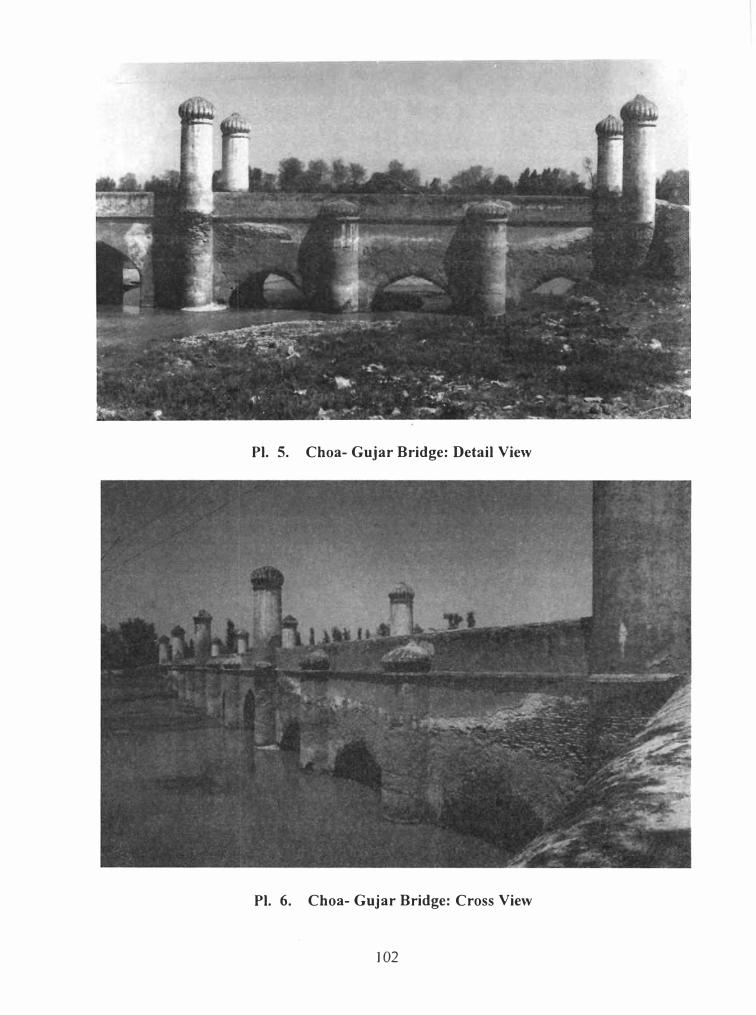
Pl. 5. Choa- Gujar Bridge: Detail View
Pl. 6. Choa- Gujar Bridge: Cross View
102
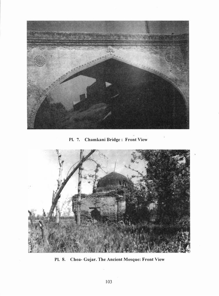
Pl. 7. Chamkani Bridge : Front View
Pl. 8. Choa- Gujar. The Ancient Mosque: Front View
103
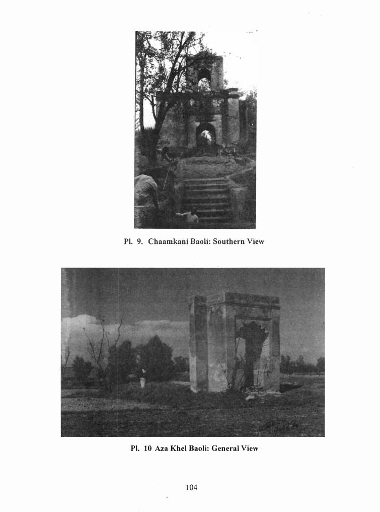
Pl. 9. Chaamkani Baoli: Southern View
Pl. 10 Aza Khel Baoli: General View
104
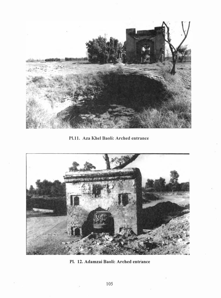
Pl.11. Aza Khel Baoli: Arched entrance
Pl. 12. Adamzai Baoli: Arched entrance
105
Pl. 13. Awai (Huwai) Baoli: General View
Pl. 14. Esori payan Baoli: General View
106
Pl. 15. Esori Bala Baoli: General View
Pl. 16. Jehangira Baoli: General View
107
Pl. 17. Khairabad : Water Mill(?): General View
108
Recommended