Welcome Investigation of Basement Flooding and Stormwater
Runoff Quality Control Study Area 36 (Etobicoke)
Class Environmental Assessment
Public Information Centre #1
View displays and discuss the study with project staff
Feel free to ask questions and fill out a comment sheet
1

Purpose of Tonight’s Meeting • To provide background on the study
purpose and objectives. • To present information on the potential
causes and factors contributing to flooding in the area and the impacts of stormwater runoff.
• To present possible alternative solutions and criteria for evaluating the alternatives.
• Outline the next steps in the study process.
• Hear from you! Your input is very important
2
Purpose of Our Study • Examine and analyze existing sanitary
sewer and storm drainage systems and identify the causes of basement and surface flooding (severe ponding on streets during large storms).
• Assess control measures to improve the quality of stormwater surface runoff as per the City’s Wet Weather Flow Master Plan.
• Assess alternative solutions to reduce the risk of basement and/or surface flooding.
• Make recommendations to: – Reduce the risk of future basement and/or
surface flooding; and – Improve the quality of stormwater runoff
before it is discharged through storm outfalls to area watercourses.
3

Study Area 36 • The Study Area is
generally bounded by: Bethridge Road to
the north; Gracie Boulevard/
LaRose Avenue to the south;
Scarlett Road/ Humber River to the east; and
Iron Street/ Precision Road to the west.
4
This area has historically experienced basement and surface flooding during major storm events.

Study Area 36
• There are thirty (30) storm sewer outfalls that discharge stormwater to Humber Creek.
5
OF3910200654
OF3928002026 OF3865003448
• The City must meet the requirements of Ontario’s Environmental Assessment (EA) Act for infrastructure projects.
• This study is being planned as a Master Plan. This requires the completion of Phases 1 and 2 of the Class EA process. We are currently at the end of Phase 1.
• The EA process is an opportunity for the public and agencies to provide input. Consultation is facilitated via two rounds of Public Information Centres (PICs).
Municipal Class Environmental Assessment Process
PHASE 1 PHASE 2
Problem Or Opportunity
Alternative Solutions
Submit Project File for 30 Day
Review Project
Completion
We are here
PIC #2
Incorporate Comments
6
PIC #1

Many steps are involved in the study before solutions can be recommended. This work includes: • Collect and review background data on land use, population, soil conditions, sanitary sewers and
storm drainage systems, flooding history, and operation/maintenance records;
• Conduct field surveys to inventory the number of roof downspouts disconnected, survey catchbasins, identify low lying areas, and inventory storm sewer outfalls;
• Identify preliminary potential causes of basement and surface flooding based on the background data review and results of field surveys;
• Develop and receive feedback on alternatives methods to reduce the risk of flooding and improve stormwater runoff water quality (1st Public Information Centre); • Develop computer models to analyze the causes of flooding and to predict flows under various
weather conditions and assess stormwater runoff impacts to receiving watercourses; • Develop and analyze alternatives to reduce the risk of flooding; • Gather input from the community and review agencies and undertake further assessment and
refinement of the alternatives; and,
• Present recommended solutions (at 2nd Public Information Centre) and finalize the study recommendations based on input from the public and review agencies.
7
Investigating Basement Flooding: The Steps Involved
We Are Here

Under normal rainfall events, the storm and sanitary sewer systems operate as designed. However, during extreme storms, the following can take place: • Stormwater flow exceeds the storm sewer capacity and overloads the system; • Directly connected roof downspouts contribute significant volumes to the sewer
system;
Basement Flooding
• Water remains on the surface and flows overland along roads during larger storm events. Excess surface water may enter basements through basement doors and windows;
• At low lying areas, water accumulates (ponds) on the surface and enters the sanitary sewer system through manhole covers. This causes the sanitary sewers to surcharge and potentially back-up into basements.
8

9
During these heavy rainfalls, the ground becomes extremely wet and water enters the sanitary system through cracks or broken pipes, cracked maintenance hole walls and loose joints underground. This contributes to back-up of the sanitary sewers. Other factors causing sanitary sewer back-up include: • Shallow groundwater table is above the sanitary sewer system in parts of Area 36; • Water can enter basements from the surface via basement doors and windows
and then enter the sanitary sewer system through floor drains; • Downspouts and weeping tiles connected to the sanitary system; • Illegal cross-connections between the storm and sanitary sewer systems; and • Oil/grease dumped into sanitary sewers causing blockages.
Basement Flooding

Typical Causes of Basement Flooding
10
11
• Urbanization has increased surface runoff, decreased infiltration into the ground and increased the potential for the transport of pollutants via surface runoff from streets, parking lots and other hard surfaces.
• Stormwater runoff often contains grit, oil/grease, heavy metals (zinc, lead, etc), bacteria, nitrates/sulfates, salt and other pollutants.
• Pollutants in the stormwater runoff adversely impact the water quality of the receiving watercourse, which can affect fisheries, wildlife, recreational uses, and visual aesthetics, etc.
Stormwater Runoff Quality
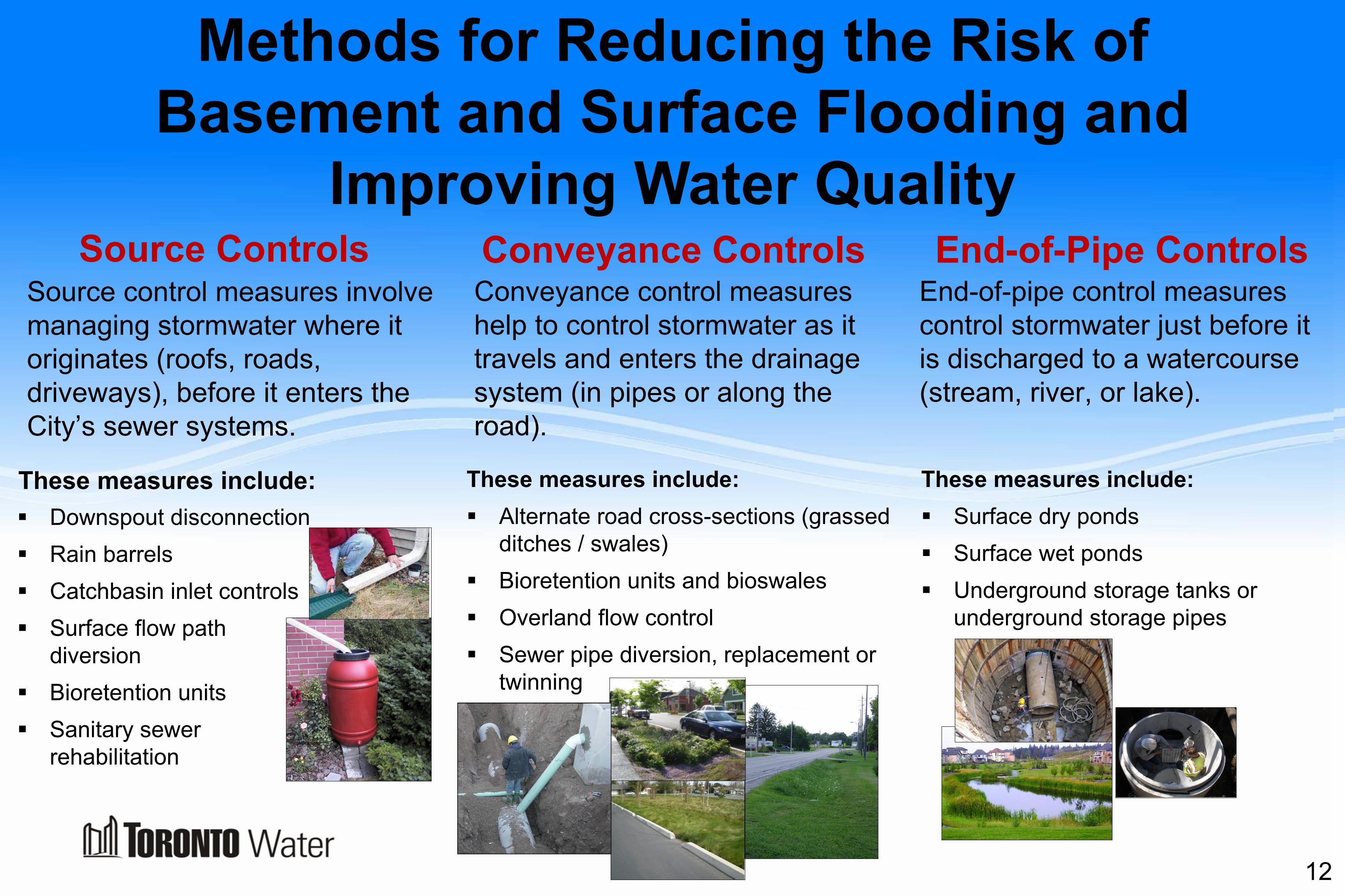
Methods for Reducing the Risk of Basement and Surface Flooding and
Improving Water Quality Source control measures involve managing stormwater where it originates (roofs, roads, driveways), before it enters the City’s sewer systems.
Downspout disconnection Rain barrels Catchbasin inlet controls Surface flow path
diversion Bioretention units Sanitary sewer
rehabilitation
Source Controls Conveyance Controls
These measures include: Alternate road cross-sections (grassed
ditches / swales) Bioretention units and bioswales Overland flow control Sewer pipe diversion, replacement or
twinning
End-of-Pipe Controls
These measures include: Surface dry ponds Surface wet ponds Underground storage tanks or
underground storage pipes
Conveyance control measures help to control stormwater as it travels and enters the drainage system (in pipes or along the road).
End-of-pipe control measures control stormwater just before it is discharged to a watercourse (stream, river, or lake).
These measures include:
12
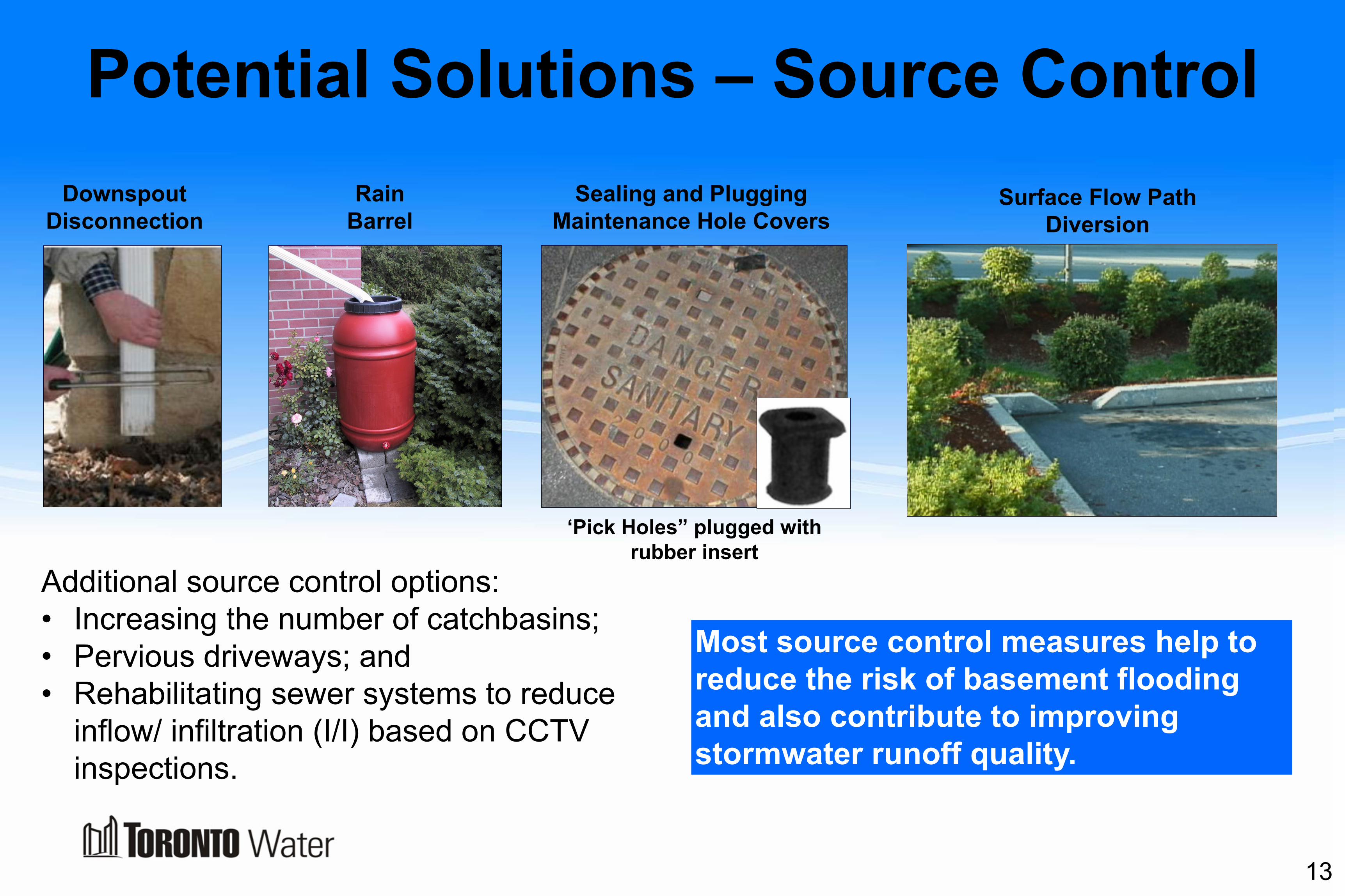
Potential Solutions – Source Control
13
Sealing and Plugging Maintenance Hole Covers
Surface Flow Path Diversion
Additional source control options: • Increasing the number of catchbasins; • Pervious driveways; and • Rehabilitating sewer systems to reduce
inflow/ infiltration (I/I) based on CCTV inspections.
‘Pick Holes” plugged with rubber insert
Most source control measures help to reduce the risk of basement flooding and also contribute to improving stormwater runoff quality.
Downspout Disconnection
Rain Barrel

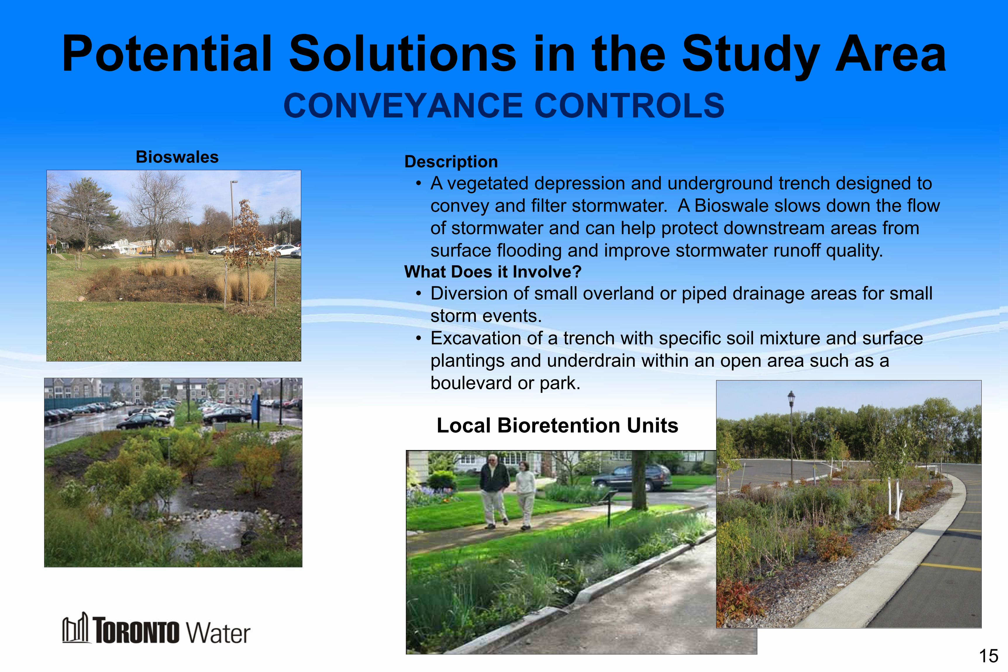
Potential Solutions in the Study Area
14
Inlet Control Devices
SOURCE CONTROLS
Description • Inlet Control Devices control the amount of water that
enters the storm sewer system during a storm event.
• Allows excess stormwater to remain in catchbasins or temporarily on the street until the storm subsides.
• Helps prevent overloading of the storm sewer system and sewer backups.
What Does it Involve? • An Inlet Control Device is installed inside the catchbasin.
It is not visible from the surface.
• Minimal time and effort are needed to install an Inlet Control Device.
Potential Solutions in the Study Area
15
Bioswales Description • A vegetated depression and underground trench designed to
convey and filter stormwater. A Bioswale slows down the flow of stormwater and can help protect downstream areas from surface flooding and improve stormwater runoff quality.
What Does it Involve? • Diversion of small overland or piped drainage areas for small
storm events. • Excavation of a trench with specific soil mixture and surface
plantings and underdrain within an open area such as a boulevard or park.
CONVEYANCE CONTROLS
Local Bioretention Units

Potential Solutions in the Study Area
16
Overland Flow (Major System) Control Description • The diversion of surface drainage away from low lying
areas that have no direct outlet, to reduce surface ponding depths.
What Does it Involve? • Addition of “speed bump” or “curb cut” to redirect
overland flow to strategic locations. • Interception of road or boulevard flows with large inlet
grate or “curb drain” to dedicated major system sewer.
Public Parking Lot Retrofit for Surface Storage Storage
Description • Installation of Inlet Control Devices in parking lot
catchbasins to store stormwater on the surface. • Installation of roof drain controls to store stormwater on
large flat roof areas.
What Does it Involve? • Retrofit of City-Owned property (where physically
possible).
CONVEYANCE CONTROLS

Potential Solutions in the Study Area
17
Replacement of Existing Storm and/or Sanitary Sewers
Description • Increase the size of the sewer pipe by replacing the old
sewer with a larger pipe.
What Does it Involve? • Road excavation within City’s Road Right of Way. • Removal of old sewer and structures (manholes &
catchbasins) and disconnection of sewer service line(s). • Placement of new sewer, reconnection of sewer service
line(s) and restoration of road and boulevard.
Adding New Sewers (Twinning) Description • Increase the capacity of the sewer system by adding
another sewer pipe in addition to the existing pipe.
What Does it Involve? • Road excavation within City’s Road Right of Way. • Replacement of old structures (manholes & catchbasins)
and reconnection of sewer service line(s) if necessary. • Placement of new sewer, reconnection of sewer service
line(s) and restoration of road and boulevard.
CONVEYANCE CONTROLS

Potential Solutions in the Study Area
18
Wet Stormwater Management Pond/Wetland Description • Wet stormwater management ponds and wetlands have
a permanent water surface that controls the quantity and quality of inflowing stormwater through storage and gradual release to the receiving system.
What Does it Involve? • Excavation and shaping of a suitable open space area. • Addition of inlet/outlet structures. • Restoration and landscaping (aquatic and side-slope). • Infrequent maintenance (sediment removal).
Dry Stormwater Management Pond
Description • An engineered surface depression that controls the
quantity of inflowing stormwater through storage and gradual release to the receiving system.
• Typically fills with water during large storm events and drains within 24 to 48 hours or less.
What Does it Involve? • Excavation and shaping of a suitable open space area. • Addition of inlet/outlet structures. • Restoration and landscaping.
END-OF-PIPE CONTROLS
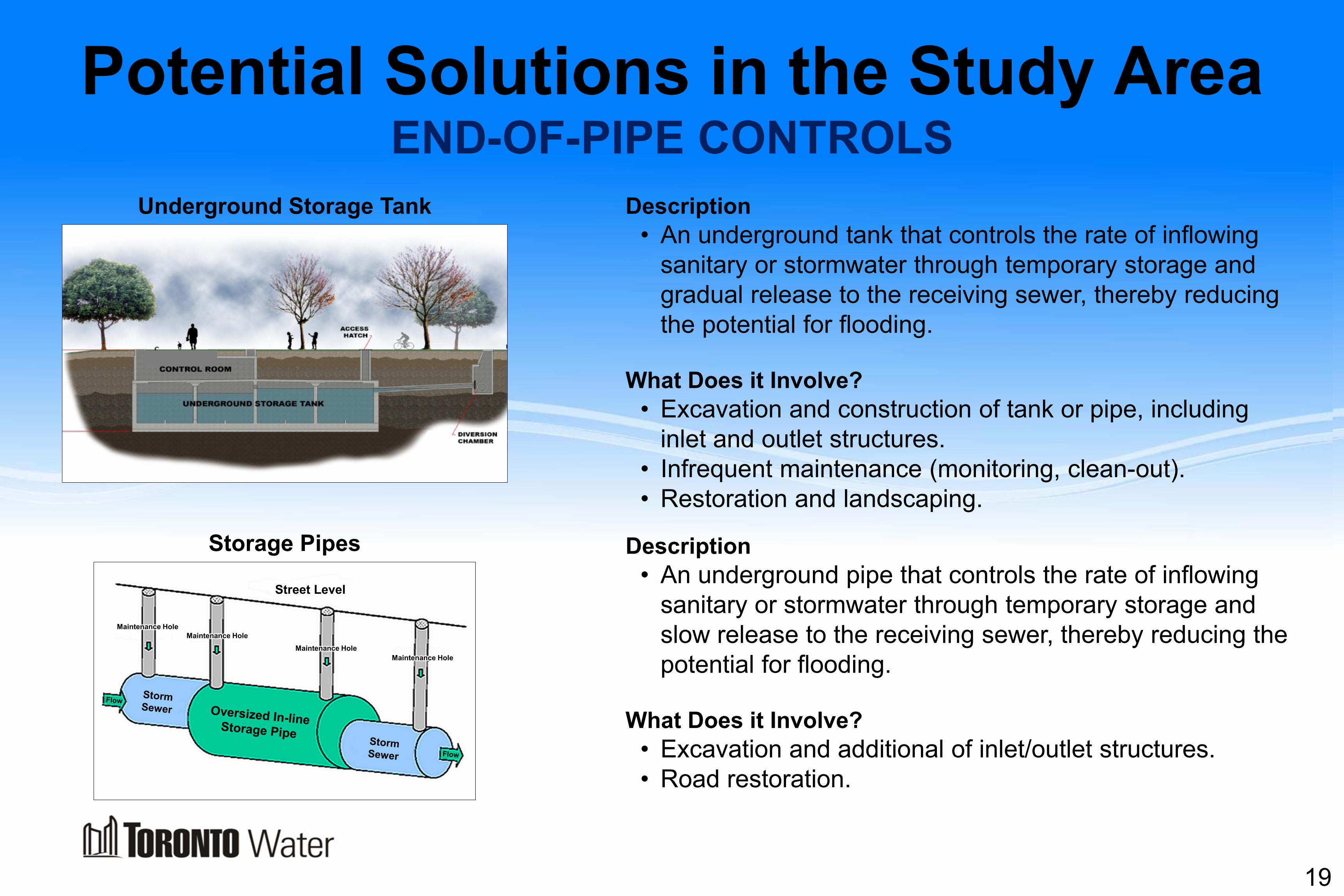
Potential Solutions in the Study Area
19
Underground Storage Tank
Description • An underground tank that controls the rate of inflowing
sanitary or stormwater through temporary storage and gradual release to the receiving sewer, thereby reducing the potential for flooding.
What Does it Involve? • Excavation and construction of tank or pipe, including
inlet and outlet structures. • Infrequent maintenance (monitoring, clean-out). • Restoration and landscaping.
Storage Pipes Description • An underground pipe that controls the rate of inflowing
sanitary or stormwater through temporary storage and slow release to the receiving sewer, thereby reducing the potential for flooding.
What Does it Involve? • Excavation and additional of inlet/outlet structures. • Road restoration.
END-OF-PIPE CONTROLS
Maintenance Hole
Street Level
Maintenance Hole
Maintenance Hole Maintenance Hole

Evaluation of Solutions
Natural Environment • Potential Impact on Terrestrial Systems
(Vegetation, Trees, Wildlife). • Potential Impact on Aquatic Systems
(Aquatic Life and Vegetation, Surface Water, Groundwater).
• Soil and Geology.
Socio-Cultural • Land Use Impacts (Parks, Ravines,
and Open Spaces) • Disruption to Existing Community
During Construction (Traffic, Noise) • Disruption to Existing Community
Post Construction (Visual Impact, Odour, Safety)
• Archaeology and First Nations
Technical • Effectiveness of control measure in reducing
surface and basement flooding and improving stormwater runoff quality.
• Feasibility of Control Measure (Available Space, Accessibility, Constructability)
• Impacts on upstream, downstream and surrounding area infrastructure.
• Impacts on operating and maintenance requirements.
Economic • Capital cost • Operating and Maintenance Costs
Economic
The following criteria are suggested for evaluating each of the alternatives and identifying the recommended solutions:
20
What are your thoughts on the evaluation criteria? Are there any additional criteria that should be considered?

Thank You for Attending
We welcome your feedback. Please fill out the comment sheet provided. Following this PIC, the study team will review and consider your comments in
the evaluation of alternative solutions. The next Public Information Centre will be held in late 2016 to present the
recommended solutions.
Contact Information For more information on this study, or to provide your comments or be placed on the
project mailing list, please contact:
Josie Franch, Public Consultation Unit 55 John Street, Metro Hall, 19th Floor, Toronto, ON M5V 3C6
Phone: 416-338-2859, E-mail : [email protected] Fax: 416-392-2974, TTY: 416-338-0889
Website: http://www.toronto.ca/bfea 21

What Can Homeowners Do to Prevent Future Flooding?
1. Residents are encouraged to complete an investigation of their property to identify potential causes of flooding.
2. Actions that may help reduce the risk of basement flooding should be investigated. These include: • Ensure yard is graded away from house, and downspouts discharge
away from foundation • Waterproofing basements • Replacing weeping tiles • Capping and severing the weeping tile connection to the City’s system • Installing a sump pump with backup power • Backflow valve on the sanitary sewer

Basement Flooding Protection Subsidy Program
To assist homeowners, the City offers owners of single-family, duplex and triplex residential homes, a financial subsidy of up to $3,400 per property, to install flood protection devices including:
• Backwater valve (max $1,250), • Sump pump (max $1,750), and • Disconnection of a home’s foundation
drains (weeping tile) from the sewer system (max $400).


!+ !+
!+!+
!+
!+!+
!+ !+!+!+
!+!+
!+!+
!+
!+
!+!+
!+!+
!+
!+!+
!+ !+
!+
!+!+
!+
REXDALE BLVD
DIXON RD
ROYAL YORKRD
GARY DR
HIGHWAY 401
LEGGETT AVE
MARTINGROVE RD
WENDELL AVEWILSON AVE
HIGHWAY 401
ROSEMOUNT AVE
ISLINGTONAVE
BELFIELD RD
HIGHWAY 409
QUEEN'S PLATE DR
YORK RD
THE WESTWAY
SCARLETT RD
HIGHWAY 27 N
SHAFT RD
KIPLINGAVE
IRON ST
NORTHCREST RD
LAWRENCE AVE W
BETHRIDGE RD
SUMMITCREST DR
LA RUSH DR
SHERIN CRT
DEETH DR
TALLON RD
LEARMONT DR
SHENDALE DR
HUNTING RIDGE
PAGE B ROOK DR
QUEENSLEA AVE
NUGENT RD
CALLOWHILLDR
LONGBOURNE DR
BRAECREST AVE
JOSEPH ST
LAVINGTON DR
CHAPMAN RD
TRIO AVE
WINNIPEG RD
FLETCHER PL
ALLENBY AVE
RONSON DR
CRANE AVE
ALBION RD
LA ROSE AVE
PETTITDR
HAWTHORNE RD
MCCULLOCH AVE
MUNHALL RD
SABRINA DR
WINDSOR RD
HADRIAN DR
BENBOWRD
SHADWICKDR
PARAGON RD
SHIPLEY RD
FELLERRD
TYNEVALE DR
RUSSELL RDCA
MPER
DOWN AVE
LOVILLA BLVD
ENTERPRISE RD
ALMA DR
GOLFWOOD HTS
EGLINTON AVE W
WESTHAMPTON DR
OAK ST
TREHORNE DR
CANS
O RD
RICHVIEW RD
FABIANPL
GREEN SBORO DR
VULCAN ST
WIDDICOMBE HILL BLVD
NAMC
O
RD
TYLER PL
ST GEORGES BLVD
KILBURN
PL
RACINE RD
WESTMOUNT PARK RDTEMPLARDR
GAYDON AVE
SUNVALE DR
WESTON RD
POYNTER DR
LUDSTONE DR
WINCOTTDR
ST PHILLIPS RD
SASKATOON DR
KINGSVIEW BLVD
SAND
WELL
DR
DIX INGTON CRES
FENLEY DR
HARTSDALE DR
BRIDESBURG D R
RIDGEMOUNT RDBRAMPTON RD
BLACKFRIAR AVEEVERNBY BLVD
DUFFIELDRD
ARCADE DR
RENAULT CRES
BREADNER
D R
MITR E PL
BROUGHAM CRES
WARBE C K PL
PRECISION RD
JARDINEPL
ARKLE
Y CRES
RUSC
OECR
ESYORKLEIGH AVE
SUN ROW DR
Humber River
Mimico Creek
Humber Creek
Basement Flooding Area 36
0 500100 200 300 400Meters Date: 3/23/16
µ
Humber RiverHumber Creek
Black CreekMimico Creek
GARY DR
DIXON RD
JANE ST
MAPLE LEAF DR
HIGH WAY 409
DUNDAS ST W
CARLINGVIEW DR
HIGHWAY427
REXDALE BLVD WES
TON
RD
HIGHWAY 27
HIGHWAY400
KIPLING AVE
ALBION RD
BLACKCREEK
DR
SCARLETT RD
PRI NC ESS MARG ARETBL
EGLINTON AVE W
EXBURY RD
FA LSTAFF AVEHIGHWAY 401BE T H RIDGE RD
QUEENSPLATE DR
DI SCO RD
RENFORTH
DRTHE KINGSWAY
HIGHWAY 427
GARDINER EXWY
ISLINGTON AVE
KIPLING AVE
EGLINTO N AVE W
THE QUEENSWAY
LAKE SHORE BLVD W
36
3541
38
39
BasementFloodingAreasKey Map
Legend_̂ Reported Basement Flooding
Basement Flooding AreaExtended Contributing StormDrainage Area
"P Storm Pumping StationManholes
!( Sanitary!( Storm!+ Outfalls
SewersSanitaryStorm
Recommended