S2G14SEe0S2 52G14SE0012B1 VALORA LAKE 010
Diamond Drilling
Area VALORA LAKE Report NO ij 6
Work performed by: Amax Exploration Inc. (W.M. Thompson)
Claim NO
2264 54
226449
226454
Hole NQ
3
i*
1
Footage
497. 0'
503.0'
503.0'
Date
Oct/73
Oct/73
Oct/73
Note
(D
(D
(D
3 OH
Notes:
Autopositve Enclosed
J: AWL.005(7-69)rev,9-72

DRILL HOLE LOG
PROPERTY: STURGEON LAKE
BEARING: South along line DIP - 55 0 (AQ-wire line)
; SECTION: 52 E AZIMUTH
l -f 00 S LOGGED BY A.O. Tammam
HOLE NO. LONG LAC-STUR L.-NO. l
HOLE STARTED Oct. 3, 1973
HOLE FINISIL-D Oct. 10. 1973
LENGTH 503.0' SIZE
MIDWEST DRILLING COMPANY
'FOOTAGE
10 ~ 38-0
38.0 - 17
178.9 - 2
212.0 - 2f
jI Ir:
DESCRIPTION
Casing
J. 9 ANDESITE LAPILLI MICRO - AGGLOMERATE
Loosely packed felsic fragments, 4 mm to 7 mn in size at 301, 10 nm to 15 ram in size at 20%, embedded in 50 % dark grey- green, fine grained matrix with visible chlorite, carbonate, sericite alterations. Occasionally the lapilli with carbonatized margin. This section is generally sheared at 45 0 - 550 to Core Axis.
.2.7 ANDESITE FLOW ( INTRUSIVE?)'
Dark grey - green in colour, very fine grained, homogeneous texture. Occasional qtz. - feldspar - carbonate stringers and veinlets. Sharp upper contact at 800 to C. A., obscured lowar contact.
0.5 ANDESITE LAPILLI MICRO - AGGLOMERATE
212.0 - 226.0 - Transitional Zone
Predominant andesitic matrix with loose, rounded to subrounded felsic lapilli 10 mn to 15 mn in size.
226.0 - 248.5 - 551 micro - agglomerates of which 30% of 4 mm to 15 mm in size, and 25% of 15 mn to 25 mm.
248.5 - 257.8 - QTZ - DIORITE DYKE
Medium grey in colour, fine grained chilled upper and bottom contacts at 800 to Core Axis, medium to coarse grained at the centre with visible qtz. - feldspar - amphibole aggregates.
i
i
t
^^^B '
0.O
1fa-
J
2
1
1 1
i
1 1
i
i
1i t1
1t

F DRILL HOLE LOGPg. 2
kONG LAC-STUR. I.. NH,PROPERTY: STURGEON LAKE
BEARING: South along lira -SIP " 55 0 (ACrwire line) HOLE STARTED Oct. 3 f 197.1
MS________ AZIMUTH _________ HOLE FINISHED Oct. 10, 1973SECTION:
00 S LOGGED BY A.O. Tanmam LENGm 503.0' SIZE
MIDWEST DRILLING COMPANY
FOOTAGE
280.5 - j
426.5 - 5
503.0
if*/*-'* "
DESCPJPl'ION
257.8 - 278.7 - Tlie same as described from226.0 - 248.5.
278.7 - 280.5 - DYKE
Medium grey, very fine to finegrained homogeneous texture.Sliarp upper and lower contactsat 85 0 to C. A.
26.5 LAPILLI MICRO fc (MACRO) AGGLOMERATES
Upper 15 feet are predominantlywell packed macro lapilli, from32 mm to 50 mm in size. The lovrerpart is an intermix of micro andmacro agglomeratic intersections.The packing, from loose to moderateincreases with depth. The lower50 feet is visibly spotted withmagnetite blebs, j mm to 1 mm in size, up to 151. Poor shearing atapproximately 850 to Core Axis.
13.0 ANDESITE FLOW (INTRUSIVE?)
The same as described from 178.9 to212.7. Upper contact obscured byqtz. veining.
END OF HOLE
!
;
\!
V
tlootUJ!HKOH30-*-n,W
P
;,.:,
r-^j
25id385~ooOH
i r*" t
i !.'
kr*-.
r

DIAMOND DRILL HOLE RECORD Co.LATITUDE STARTED
DIP TESTP**t*g* C*rr*et*J
'
:.-; HO. Ao"j L**c - L- -^o J DEPARTURE FINISHED
ELEVATION LEHOTM
PI-. -. Q- Wfrc UvC ; SECTION LOGGED BY /^. 0 . ~7tr t,, Mf fTf^


PROPERTY HOLE HO. - ST- 7 --,- ~
FOOTACET.
DESCRIPTION SAMPLE NO.
FOOTAGE T.
ASSAYS "l
'^agTf^'garT^
13^^ -*L——^
n."7 A—&-O cj^ fo-e-f f*/?.
~ASfr Of?. /-/Of.
. i l -f--
i- i. —.-i—.L. i•T-
_ _ — i ——...i.' :..—. i. ...
^AIEULCM NINC Of
x-H
1 'i-O-
— - . . t
- f--.,,--J—-..
l

DRILL HOLE LOG
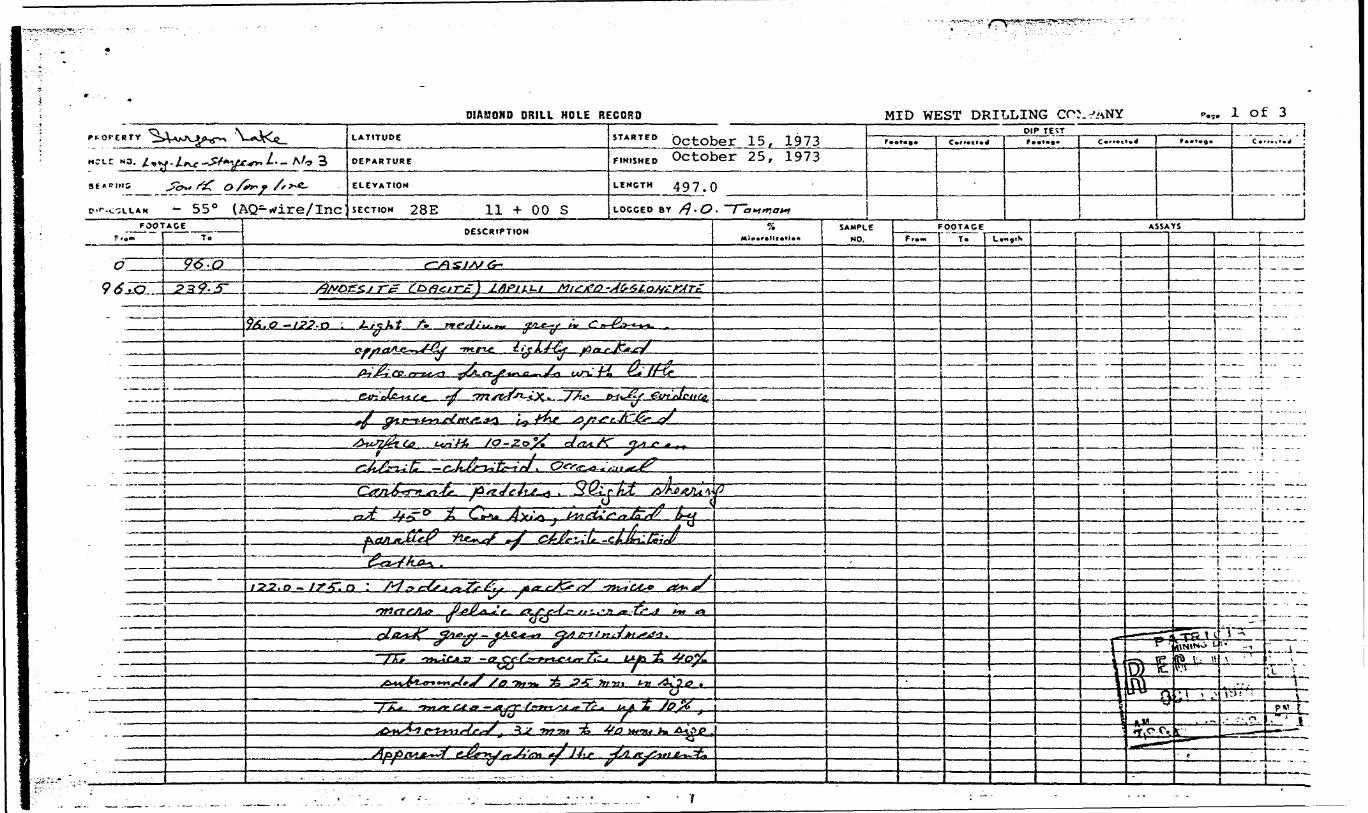
PROPERTY: STURGEON LAKE HOLE NO. LONG LAC-STURGEON L. NO 3
IBEARING: South along line DIP -550 (AO-wire/Inc) HOLE STARTED October 15. 1973
SECTION: 28 E AZIMUTH HOLE FINISHED October 25, 1973
11 4- 00 S LOGGED BY A. O. Tanroan LENGTH 497.0 SIZE
FOOTAGE
0 - 96.0
96.0-239.
-
DESCRIPTION
Casing
. ANDESITE {DACITE) LAPILLI MICRO-AGGLOMERATE
96.0 - 122.0 - Light to medium grey in colour.- apparently more tightly packed
sileceous fragments with littleevidence of matrix. The onlyevidence of ground mass is thespeckled surface with 10 - 201dark green chlorite-chloritoid.Occasional carbonate patches.Slight shearing at 450 to CoreAxis, indicated by parallel trendof chlorite-chloritoid lathes.
122.0 - 175.0 - Moderately packed micro and macrofelsic agglomerates in a darkgrey - green groundmass.The micro - agglomerates up to 401 subrounded 10 mn to 25 irm insize. The micro - agglomeratesup to 101, subrounded, 32 irm to40 mm in size. Apparent elongation of the fragments at30 0 to 40 0 to Core Axis. Chloritealterations is mainly in the groundmass but occasional carbonate occurr locally rimning the fragments or as patches.
175 . 0 i - 176 . 5 - QUARTZ DLORITE DYKE
- Medium grey in colour, medium grained, with 1" fine graineddrilled contacts; contacts sharpat 70 0 to Core Axis. Apparentflow texture at 70 0 to C. A.
176.5 - 239.5 - The sarre as from 122.0 - 175.0
-
S-.
D.,0tot.
inlo.S[o' nJ
Q.DO
^ iZO
OSs* *J
IIOHDC If8 :itX. 'n,j
' -
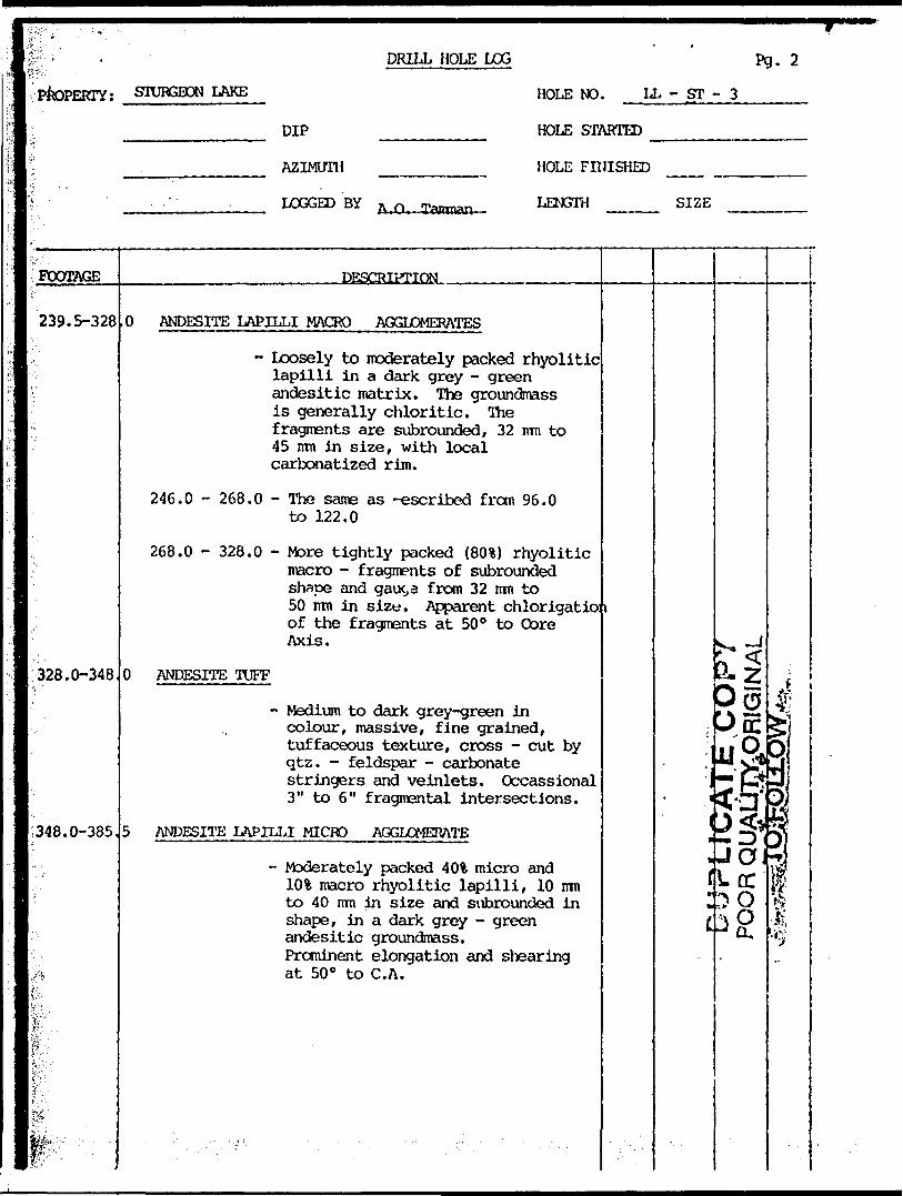
DRILL HOLE LOG Pg. 2
STURGEON LAKE
DIP
AZIMUTH
LOGGED BY ZUO—Taircnan-
HOLE NO. LL - ST - 3
HOLE STARTED
HOLE FINISHED -
LENGTH SIZE
FOOTAGE DESCKBTION-
239.5-328,0 ANDESITE LAPILLI MACRO AGGLOMERATES
- Loosely to moderately packed rhyolitic lapilli in a dark grey - green andesitic matrix. The groundmass is generally chloritic. The fragments are subrounded, 32 mn to 45 mn in size, with local carbonatized rim.
246.0 - 268.0 - The same as -escribed from 96.0 to 122.0
268.0 - 328.0 - More tightly packed (801) rhyolitic macro - fragments of subrounded shape and gauc,3 from 32 mn to 50 irm in size. Apparent chlorigatio: i of the fragments at 500 to Core Axis.
328.0-348 ANDESITE TUFF
- Medium to dark grey-green in colour, massive, fine grained, tuffaceous texture, cross - cut by qtz. - feldspar - carbonate stringers and veinlets. Occassional 3" to 6" fragmental intersections.
348.0-385 ANDESITE LAPILLI MICRO AGGLOMERATE
- Moderately packed 40% micro and lOSi macro rhyolitic lapilli, 10 mn to 40 mm in size and subrounded in shape, in a dark grey - green andesitic groundmass. Prominent elongation and shearing at 50 0 to C.A.
rm^
atfLcC
OQ,
'*.
*

DRILL HOLE LOG . 3
Pk)PEKTY:
DIP
AZIMUTH
LOGGED BY A.O. Tanroan
HOLE NO. LL - ST - 3
HOLE STARTED
HOLE FINISHED
LENGTH SIZE
385.5-497 ANDESITE TUFF
- Medium to dark grey - green, fine grained dense texture, numerous qtz. stringers and veinlets. Local narrow intersections (l" to 5") of micro - agglomerates with moderate shearing at 50 0 to 70 0 to Core Axis.
497. END OF HOLE
DIAMOND DRILL HOLE RECORD MID WEST DRILLING l of 3
PROPERTY
MCt-t NO.
3E*"!"5 O /tt" f /f r*-
- 55 0 (AQ-rfire/Inc
LATITUDE
DEPARTURE
ELEVATION
SECTION 28E 11 + 00 S
STARTED October 15, 1973October 25, 1973
LENGTH 497.0
DIP TEST
LOGGED BY /? . O - ~~T~awai*1
1FOOTAGE
DESCRIPTION SAMPLE
NO.
FOOTAGEFr.m To L
ASSAYS
S6^L—\
9635-~ 239.5- AVGES.J 1-c
&1 lij^tl
-^?— - t ^
5f
o :
^j^U
d^ y j-t?."GO
S0 tots,W
6t ir —*:-
Tvr-Ht -t, 4a Httu t*A\?P"^77u-
r s

HOI e NO. L L -S~T^FOOTACE
T.DESCRIPTION SAMPLE j __ FOOTACE ^
NO. ' From To j L*"gth
ASSAYS.. r-
j^OL^rzr-gg-L- x z35zi;gxSx^LjLZ*.
JO^
tff* O -. I7&. -D/oStrt A
"~#*-J^:
Z&l u-ix^rt^-T^ex&i*^.~a3nfe j &J&A!
32&0
t '.ffj^fy—yT- -rt^
-^-9- * If
I^Ij^Li^^^^^^^eia^
... i_____
... - .__j.^.
.—.f: ..L.,. — .—-
|"i~
.L
- —— l-

PROPERTYFOOTAGE
T.DESCRIPTIOM
HOLE NO. LL-5/— c.*. 3
SAMPLENO.
FOOTACE. .Lvn^th
dLLASSAYS
^^
Sa23^^^*^-J??lrff2^li
"^* ,-*VCy *" -g. -f"-*-^*
-^-^-^
HI.//?' J^-^<L&l^P-- SL2jtf-*-4L;~[t t^ ^at^^tt' /O -l . ________y . T^^^. 7 ^ y
I
:t"rr:

DRILL HOLE LOG
PROPERTY: STURGEON LAKE HOLE NO. LONG LAC - No. 4
BEARING: SOUTH ALONG LINE DIP -55" (AQ-wire line) HOLE STARTED Oct. 28, 1973
AZIMUTHSECTION: 56 E HOLE FINISHED Nov. 5, 1973
10 * 00 N LOGGED BY A.O. Tammam
MIDWEST DRILLING COMPANY
LENGTH 503.0 SIZE
FOOTAGE
0 - 22.0
22.0 - 18
DESCRIPTION
Casing
7.3 DACITE - RHYODACITE LAPILLI TUFF f, AGGIOMERATES
22.0 - 42.0 - Medium grey in colour, mediumgrained, soft, heavily sericilizedwith poor foliations at 70 0 toCore Axis; occassional fine pyritedessimination^^. Local vugs andrusty fractures.
42.0 - 66.3 - Medium dark gray in colour, veryfine grained, homogeneous texture,resembling altered Dacite tuff.
53.3 - 60.7 - Elongated and brecciatecfelsic macro - fragments30 mn to 40 mm in length with^2\ pyrite dessimination.
66.3 - 82.0 - Medium grey in colour, soft,heavily sericitic tuff with localfragmental sections, pronouncedfoliation and shearing towardthe bottom at 45 0 to C. A. ;pyrite dessimination Ol
82.0 - 83.5 - Thinly bedded felsic and darkgray tuff bands 2 mn in width.
83.5 - 94.0 - Medium light gray in colour,sheared felsic fragments,generally brecciated andsericitized, occasional pyritedessimination <2%
94.0 - 99.0 - Medium - fine grained tuff,pronounced shearing at 75" to C. A.
96.0 - 97.0 - Sericitized, brecciatedfelsic fragments.
l
i
t* ^
X ZD oD *u* ^cciV'.O-^^ u'J ̂S3X rt
', ( )- '. .)IX
i ; (" (
V *T i; - i
r̂^10LLv*' ' w**
,
i
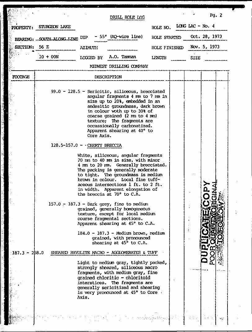
DRILL HOLE LOG Pq. 2
HOLE NO. LAC - NO-PROPERTY: STURGEON LAKE ______________
ra..T,TOE DIP - 55C (AQ-wire line) HOLE STARTED ^:S?±'-?*±}™L
AZIMUTH
BEARING: SOUTH
Ife, SECTION: 56 E HOLE FINISHED Nw 5, 1973W--" o -f OON LOGGED BY A*0' Tanman LENGTH
MIDWEST DRILLING COMPANY
SIZE
FOOTAGE DESCRIPTION
99.0 - 128.5 - Sericitic, siliceous, brecciated angular fragments 4 irm to 7 irm in size up to 201, embedded in an andesitic groundmass, dark brown in colour woth up to 30 % of coarse grained (2 mn to 4 ram) texture; The fragments are occassionally carbonatized. Apparent shearing at 40 0 to Core Axis.
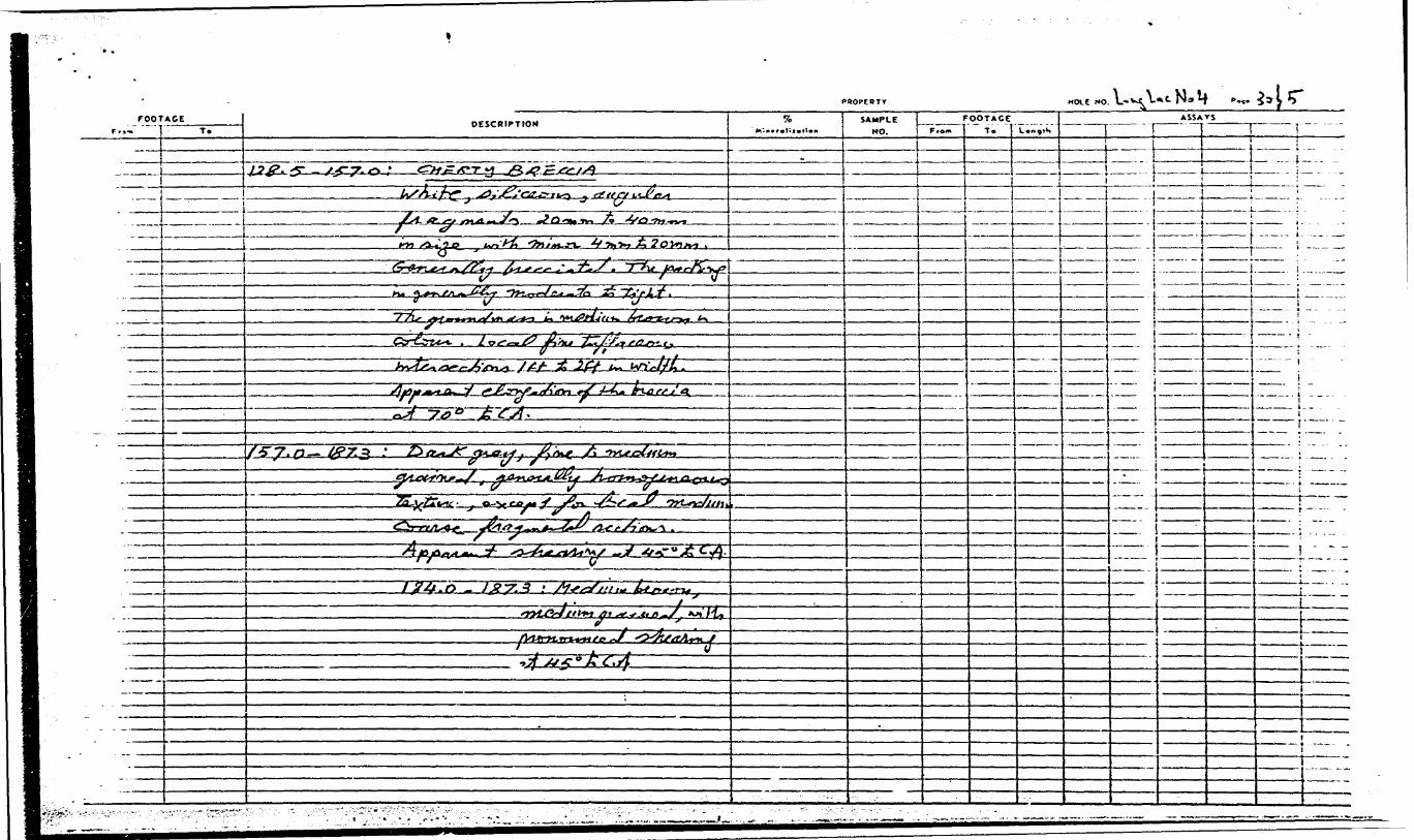
128.5-157.0 - -CHERTY BRECCIA
White, siliceous, angular fragments 20 mn to 40 mn in size, with minor 4 mm to 20 nm. Generally brecciated. The packing is generally moderate to tight. The groundmass is medium brown in colour. Local fine tuff aceous intersections l ft. to 2 ft. in width. Apparent elongation of the breccia at 700 to C.A.
157.0 - 187.3 - Dark grey, fine to medium grained, generally homogeneous texture, except for local medium course fragmental sections. Apparent shearing at 450 to C.A.
184.0 - 187.3 - Medium brown, medium grained, with pronounced shearing at 450 to C.A.
187.3 - 2 S8.0 SHEARED RHYOLITE MACRO - AGGLOMERATES S TUFF
Light to medium gray, tightly packed, strongly sheared, siliceous macro fragments, with medium gray, fine grained chloritic - chloritoid interstices. The fragments are generally sericitized and shearing is very pronounced at 450 to Core - Axis.

t!! 1
?
it
:;
if'
li"'
f.
't ]
*
i
i
rV
*
!'
a
f;
-. - -. ^ ' *.
DRILL HOLE LOG Pg. 3
PROPERTY: STURGEON LAKE HOLE NO. LONG LAC - NO 4
BEARING: SOUTH ALONG LINE DIP - 550 (AQ-wire line) HOLE STARTED Oct. 28, 1973
SECTION: 56 E AZIMUTH HOLE FINISHED Nov. 5, 1973
10 * 00 N LOGGED BY A.O. Tamman LENGTH SIZE
MIDWEST DRILLING COMPANY
FOOTAGE
258.0 - 2
275.5 - 3
328.5 - 5C
503.0
i
DESCRI.PTION
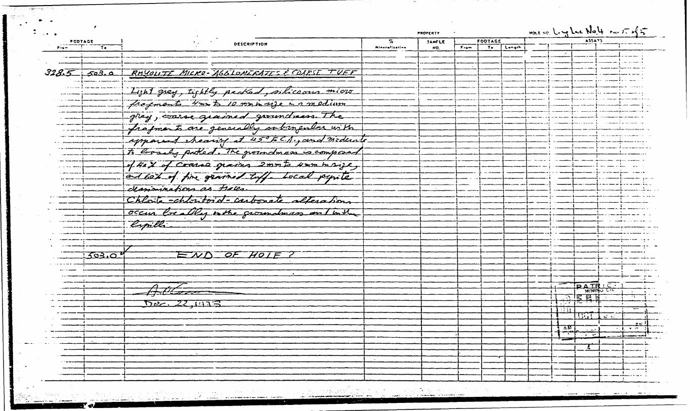
'5.5 RHYOLITE TUFF
Light grey, medium fine grained,homogeneous texture; generallysilisceous with chlorite - chloritoidlathes up to 10%. Occassionalcarbonatious patches. Upper andlower contacts are obscured. Localpyrite dessimnation up to 5%
!8.5 RHYOLITE MACRO - AGGLOMERATES 6, TUFF
Light grey, siliceous, tightlypacked, elongated macro fragmentswith dark grey, fine grained chloritic- chloritoid interatices. Apparentbrecciation of the fragments withchlorite filling. The shearing ispoor if compared with section187.3 - 258.0. Gradational bottomcontact .
3.0 RHYOLITE MICRO - AGGLOMERATES 6 COARSE TUFF
Light grey, tightly packed, siliceousmicro fragments 4 mm tc 10 mm insize in a medium grey, coursegrained groundmass. The fragmentsare generally subangular withapparent shearing at 45C to C. A.,and moderate to loosely packed. Thegroundmass is composed of 40% ofcoarse grains 2 mm to 4 mm in size,and 60% of fine grained tuff. Localpyrite dessimination as traces.Chlorite - chloritoid - carbonatealterations occur locally in thegroundmass and in the lapilli.
END OF HOLE
f-**
fi.OOLULM,
^
O KM
. f
(
-
-J
24o.?.|CD^oprji^ji -t'fT-J rj#^W?? OyC2 JT^I
i5 - - ;u '-ci*wl
1
i

lDIAMOND DRILL HOLE RECORD PGtLlifiG C?
LATITUDE STARTED7? tmmtmgm C**r*ct*4
DIP TESTF**t*Q*
HCLE HO. \.*v^ Y. DEPARTURE FINISHED f C, '"?7? ——iGf^RIHG /r*Vt. ELEVATION LENGTH
- Z ^'/'flQ- /\/ LOGGED BY f\' O

HOI C NO. L.-* *...FOOTAGE
DESCRIPTIONSAMPLE
MO.
FOOTAGE ASSAYS
gx-.y. o A ___.__...L. i _____
"tx
^ --J-
^
/T
I^^Z^Z^I
2:
y^^.^~r
'-I- -- ..___l ., - ,.
It__. l.
4^-pn*r*L*rL~*ifo~/ -̂ TtsaJlri^J

I———T't1"

J'
•N
^)y
w.l-V.
X
*,
i\-jp**:- fj-i*ip'/^f-JM
J
- lv
fi
l.-?i~~7—
1^,5'
^•o
lJo o5- iA
t J* ^0
^xS
Jl-^ ^^1^i
1 J-"S
S
4**w
^- -^
t/^'^
*vv*
^V
*S
lft^
f-̂ O*\\u jt M
\A
AkrCrtSiVl

NJ.V7 ViMONTARIO
To the Recorder of.
OF WORK
A porate form li required for each type of work to be recorded.
.,....,.. ...........Mining Division
name of Recorded Holder Miner's Licence iMtfy.?.,.. Ontario........ .............
Post Office Addressdo hereby report the performon;e of ........1.5.9.?........................ doys of .,, DIft.. '..0.0.4. '..r.iiU/lg...
type of work not before reported to be applied on the following contiguous claims
Claim No. Days Claim No. Doys Claim No. Doys
52GMSE0ei2B1 VALORA LAKE 900
The Required Information is o* Follows: (Attach o list if this space is insufficient)
Dlar. ond Drill Operator Midwest Di*' ond Drilling fi^O King Edward Street WINNIPEG, Manitoba RH3 OP?
Drilling conducted betwci Oct. l - Nov. 30, 197?
Dote
1 !or O
2 !Ol/)S-Q. i l
All the work was performed on Mining Claim (s) ,.....f?A..?^7.Q.7.?. ....F.A.21/.1.62......................................... H(In the cose of geological and/or geophysical survey (s), where more than 18 claims ore involved attach o schedule) *
READ CAREFULLY; THE FOLLOWING INFORMATION IS REQUIRED BY THE MINING RECORDER. x j
For Monuol Work, Stripping or Opening up of Mines, Sinking Shafts or Other Actual Mining Operations — Names ond o i addressee of the men who performed the work ond the dotes ond hours of their employment. X; For Diamond and other Core Drilling - Footoge, No. ond angle of holes and diameter of core. Name and address of Jo i owner or operator of drill. Dotes when drilling was done. Signed core log ond sketch in duplicate. For Compressed Air or Other Power Driven or Mechanical EquipmentType of drill or equipment. Names and addresses of men engaged in operating equipment ond the dates ond hours of their employment.For Power Stripping * Type of equipment. Nome ond address of owner or operator, Amount expended. Dates on which work was done. Proof of actual cost must be submitted within 30 doys of recording.With each of the above types of work sketches are required to show the location ond extent of the work In relation to the nearest claim post. In the case of diamond or other cor* drilling the sketch must b* submitted In duplicate, For Geophysical, Geological, Geochemicol Surveys ond Expenditure Credits - the name of author of report, Covering dates of survey (linecutfing 8, office). Type of instrument used. Total amount of expenditure. Technical reports, mops.expendjture breakdown, receipts must be filed in duplicate with the Minister within 60 days of recording. For Land Survey * the name ond address of Ontltio Land surveyor.
of Recorded Holder or Agent
i/) : UJ
ScclP :o:2 i
oa.UJ i Of i i/) ,x .:h- i
liUJ
feivi i.J j O u.
The Mining Act Certificate Verifying Report of Work
(Post Office Address)hereby certify:
- 1. That l have o personal and intimate knowledge of the facts sot forth in the report of work annexed here to, having performed the work or witnessed some during ond/or ofterJts completion.
2. That the annexed report is true.
Dote
012
mf;Vi
W
m' i'W':

fCLAIM NO. DAYS
PA 210497
PA 211162 '
PA 211163
PA 211164
PA 211166
PA 211167
PA 221 61 P
PA 221619
PA 227061
PA 227062
PA 227063
PA 227064
PA 227065
PA 227066Fa. i. 2 706? PA 227068
PA 227069
PA 2270 ' }
PA 227071
FA 227072
PA 22707? f-
PA 227074
PA 227075
PA 227076
PA 227077
PA 227076PA 227079 PA 227080
53.
5?.
5?.
5?.
5*.
5?.
5?.
5?.
53.
54.
54.
54.
54.
54. 54 54.
54.
54.
54.
54.
54.
54.
54.
54.
54.
!C. ./fi
PA~T^TA" "~~
l E STiTv K fi";'OCT151974 ^
Ju

SEE ACCOMPANYING MAP(S) IDENTIFIED AS
LOCATED IN THE MAP CHANNEL IN THEFOLLOWING SEQUENCE
(X)

8W 4W 00 4E 8E I2E 16E 20E 24E 28 E
Sturgeon
JackpotBoy
52G14SEC052 52GI4SE8C12B1 VALORA LAKE 200
227077 l Sg J Z27074 12UI63
227076 '22707*227073 ,o^
LOCATION MAP
O5
CONTOUR INTERVAL'10%
HORIZONTAL COMPONENT OF FIELD STRENGTH AS C OMPARED TO NORMAL FIELD STRENGTH.
AM AX EXPLORATION INC. GAUTHIER GROUP
STURGEON LAKE AREA -ONTARIO
RADEM"VLF-EM" SURVEYFIELD STRENGTH CONTOURS
400 O 4OO^•^^^^^jjSCALE OF FEET
800
Recommended