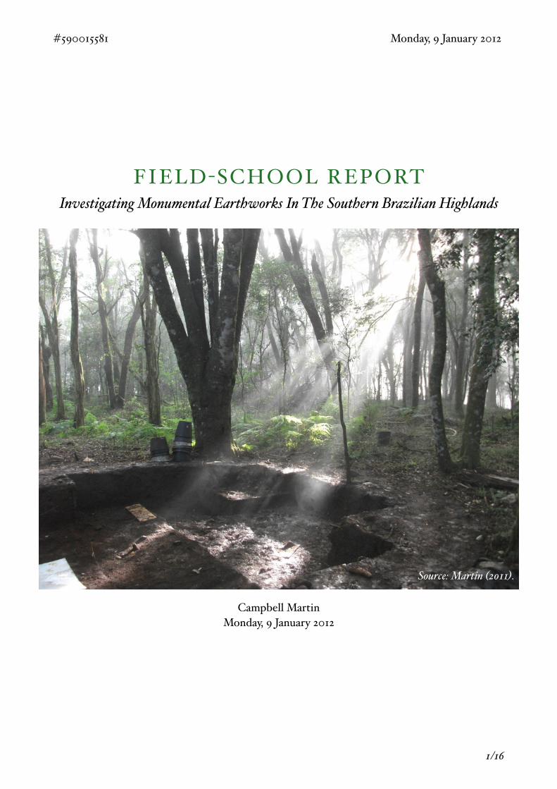
FIELD -SCHOOL REPORTInvestigating Monumental Earthworks In The Southern Brazilian Highlands
Campbell MartinMonday, 9 January 2012
#590015581! ! ! ! ! ! ! ! ! Monday, 9 January 2012
! 1/16
Source: Martin (2011).
TABLE OF CONTENTS
Background To Research! 3History of Research! 3
Location! 3
Aims! 6Understand the Chronology and Nature of the Site! 6
Surveying! 7
Preliminary Findings! 10Dugout Structures! 10
Individual Finds! 10
Lithic and Ceramic Fragments! 10
Hand Axe! 11
Circular Imprint! 11
Plate! 12
Stone Clusters! 12
Core Samples! 13
In Its Wider Context! 14Spatial Analysis! 14
Plans For The Future! 15
Bibliography! 16
#590015581! ! ! ! ! ! ! ! ! Monday, 9 January 2012
! 2/16
BACKGROUND TO RESEARCHThe Site And Its Historical Setting
History of Research The history of archaeological research in Brazil is a complex and controversial one. Early archaeology in Brazil was conducted almost exclusively by untrained enthusiasts, however this changed from 1955 through to 1985 with a huge increase in funding and development of the academic infrastructure. It should be noted that the later part of this period saw the arrival of salvage archaeology, an expanding interest in the Jê language culture and the archaeological traditions associated with it (Meggers. 1985). Although archaeologists working during this time have been criticized for working with a military regime (Funari. 2002) and relying on the suppositional premise of artificial separation (Noelli. 2005), it is seen as a golden age for archaeology which paved the way for future development (Delle et al. 2003).
! In July of 2001, Energética Barra Grande S.A. (BAESA) began construction on the Barra Grande Hydroelectric Power Station on the Pelotas River between the municipalities of Anita Garibaldi and Pinhal Da Serra (Alcoa. 2012). As a result, a program of salvage archaeology was commissioned between 2001 and 2003 to find archaeological sites that could be affected by the Barra Grande. Under the direction of Dr. Silvia Copé, the study managed to survey 528km2 which resulted in the discovery and mapping of 104 archaeological sites of the Taquara/Itararé tradition (Copé. 2007, p16-17). Copé’s findings paved the way for more detailed research to take place, focusing on specific sites and defined topic areas. The subsequent research greatly furthered our understanding of many aspects of the Taquara/Itararé tradition.
! In 2009, a group led by Dr. José Iriarte surveyed several sites and partially excavated Posto Fiscal. In 2010, Iriarte was given funding by the Wenner-Gren Foundation to “aid co$aborative research on 'Sacred Places and Funerary Rites: The Longue Durée of Southern Jê Monumental Landscapes'” (Wenner-Gren. 2010) and in 2011 another group led by Dr. Iriarte revisited Pinhal De Serra in order to continue work into the burial practices of the Taquara/Itararé. They resumed excavation and surveyed sites to further increase the understanding and contextualization of the Taquara/Itararé tradition and its environment.
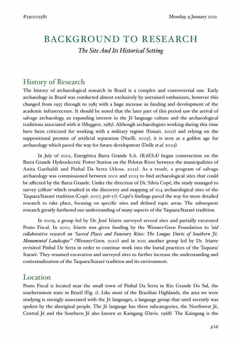
LocationPosto Fiscal is located near the small town of Pinhal Da Serra in Rio Grande Do Sul, the southernmost state in Brazil (Fig. 1). Like most of the Brazilian Highlands, the area we were studying is strongly associated with the Jê languages, a language group that until recently was spoken by the aboriginal people. The Jê language has three subcategories, the Northwest Jê, Central Jê and the Southern Jê also known as Kaingang (Davis. 1968). The Kaingang is the
#590015581! ! ! ! ! ! ! ! ! Monday, 9 January 2012
! 3/16
name given to the native tribes of São Paulo, Paraná, Santa Catarina and Rio Grande Do Sul who are “linguistically and culturally related to one another” (Métraux. 1946. p445). Rich ethnographies of the Kaingang recorded by Jesuit missionaries and anthropologists give detailed insights into many aspects of the culture which can be used to draw parallels to archaeological traditions.
#590015581! ! ! ! ! ! ! ! ! Monday, 9 January 2012
! 4/16
Figure 1.Map showing the municipality of Pinhal Da Serra (highlighted in green), within the state of Rio Grande Do Sul. Inset shows the location of Rio Grande Do Sul (highlighted in red) within Brazil.Modified &om Wikipedia (2011a).
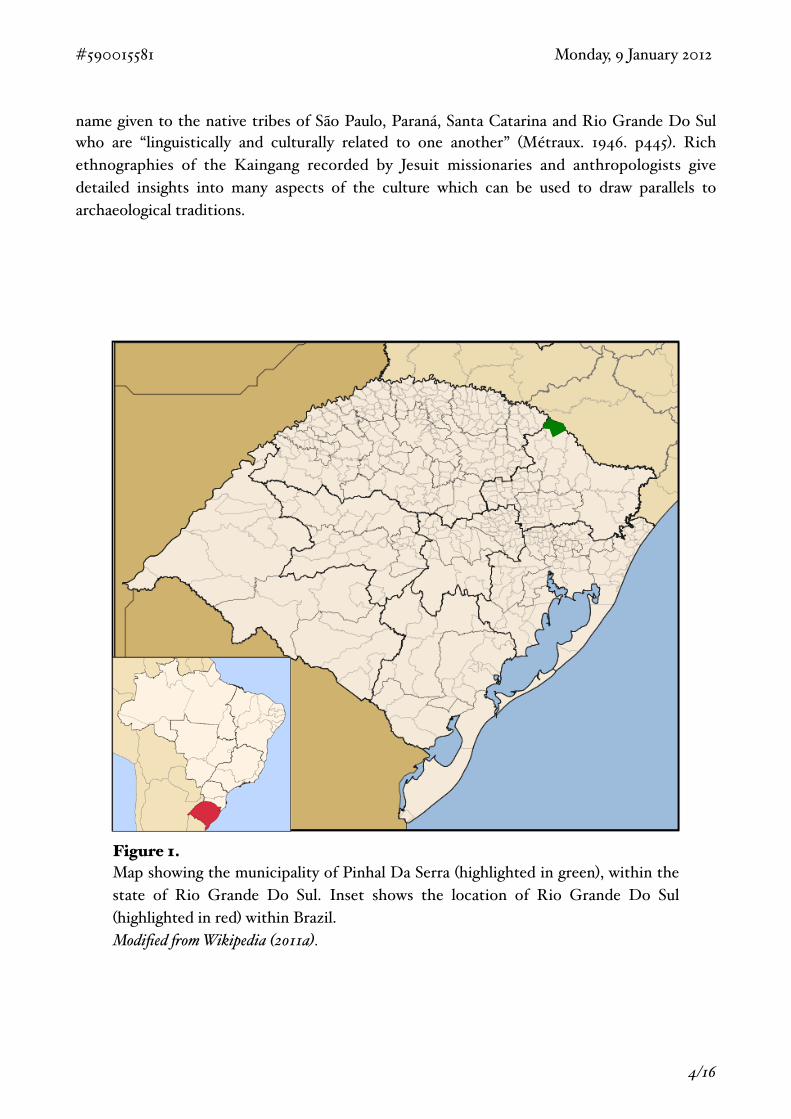
! The exact history of the Jê language is heavily debated however the territory held by the Kaingang compared to the archaeological culture of the Taquara/Itararé (Fig. 2), suggest that there must be a connection between the two (de Souza. 2011). The Taquara/Itararé is a pre-colonial tradition dating from 220BC and characterized by its distinctive ceramic style, pit house complexes, use of Araucaria, monumental enclosures and ring-mound burials (Iriarte, Gillam and Marozzi. 2008).
! Research by Iriarte and Behling (2007) suggest that climatic changes peaking in Rio Grande Do Sul by 900 cal. yr. BP had a great impact on the Taquara/Itararé people. This is evidenced by the strong correlation between changes in climate and increases in permanent Taquara/Itararé settlements and the development of the ceramic tradition. The change towards a wetter climate allowed the Araucaria Angustifolia to thrive and forming large Araucaria forests. Pollen analysis shows a huge increase in Araucaria pollen between 1100 and 430 cal. yr. BP from 39% to 80% (ibid). The increase in Araucaria not only offered shelter from the elements for the Taquara/Itararé, it also provided a valuable new resource in its seeds. These seeds were a major element in the diet of the Taquara/Itararé which can be seen in both the ethnographic and archaeological record. Copé (2007) records charred seeds at site RS-AN-03 suggesting that they would have been roasted before consumption. This can be related to Métraux’s (1946) account of the preparation of the seed in the Kaingang culture who also are described roasting the seed in the embers of a fire further connecting the two traditions.
#590015581! ! ! ! ! ! ! ! ! Monday, 9 January 2012
! 5/16
! ! Figure 2.This map shows the estimated extent of the Jê language in the past (shown in blue) in comparison with the modern Kaingang language (shown in yellow), both overlaid onto a map showing the territory of the Taquara/Itararé tradition.Source: modified &om De Souza. (2011), with Jê language data &om Wikipedia (2011b) and Kaingang language data &om Gippert (1993).
AIMSTowards A Holistic Understanding
Understand the Chronology and Nature of the SiteThe Taquara/Itararé tradition is associated with 5 main types of archaeological sites, these are “casas subterrâneas, abrigos com sepultamentos, áreas com cerâmica dispersa, áreas entaipadas e áreas com montículos” (Beber. 2004. p26). Posto Fiscal consists of three circular ring-mound enclosures, the middle of which has had a rectangular extension added to its eastern side some time in its history, these ring mound structures are thought to be burial monuments. They sit on top of a hill at an approximate elevation of 920 meters and the whole site spans approximately 135 meters. The site is currently hidden in woodland, however the trees have been planted by the land owner and do not reflect the environment of the time. It is likely that an Araucaria forest would have been on the hilltop leaving the site prominently visible.
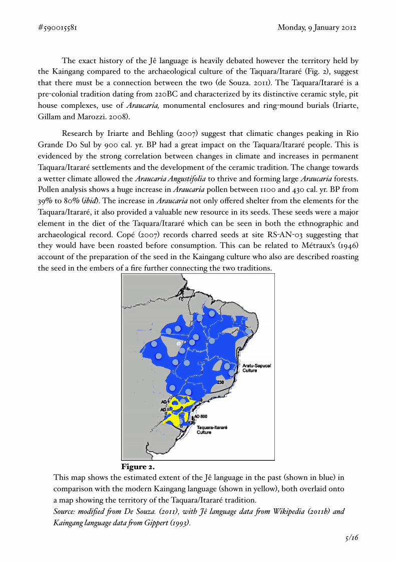
! Although most earthworks associated with the Taquara/Itararé are simple circular rings with one central mound, such as those shouldering the keyhole earthwork at Posto Fiscal or SC-AG-98 (Iriarte, Gillam and Marozzi. 2008), sites with later additions and annexes have been recorded. A site which holds a striking resemblance to Posto Fiscal is the Esmeralda site RS-PE-31 (Fig. 3), the oldest structure is the small circular burial ring, later a larger ring-mound was
added and finally a rectangular annex with a burial mound. The layout of Posto Fiscal suggests at least 3 phases of construction (Fig. 4), however it is likely that, similar to RS-PE-31, the two smaller rings are older therefore making 5 phases of construction likely.
Mound B was the focus for the excavation and the main aim was to understand how it was built and for what reason. Its location within the ring structure is interesting as the mound falls in line with the ring of the original structure. This could go some way to explaining why it is so much more pronounced than the other mounds as the builders must have flattened the ring and so would have had access to much more soil material. To understand the structure better we continued and expanded the original excavation area.
#590015581! ! ! ! ! ! ! ! ! Monday, 9 January 2012
! 6/16
Monumental burials and memorial feasting
Figure 2. Mound and enclosure complexes from south-eastern Brazil and Argentina. (Esmeralda and RS-PE-31 (Schmitz& Becker 1991: 293); SP-IP-8 Itabera (Chmyz et al. 1968: 19); SG-AG-98 and SC-AG-99 Anita Garibaldi (De Souza2007); RS-PE-21 Pinhal da Serra (De Souza 2007); SC-AG-12 Campos Novos (De Masi 2005: 233); PM01 ElDorado(Wachnitz 1984: 207)).
950
Figure 3.Ring-mound structure of RS-PE-31, Emeralda. An example of a keyhole site similar to Posto Fiscal. Source: modified &om Iriarte, Gi$am and Marozzi (2008. Figure. 2).
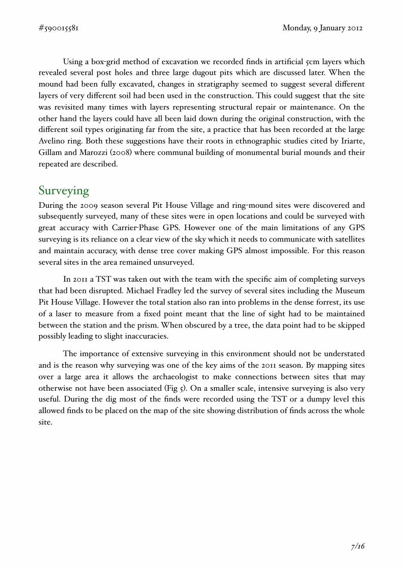
! Using a box-grid method of excavation we recorded finds in artificial 5cm layers which revealed several post holes and three large dugout pits which are discussed later. When the mound had been fully excavated, changes in stratigraphy seemed to suggest several different layers of very different soil had been used in the construction. This could suggest that the site was revisited many times with layers representing structural repair or maintenance. On the other hand the layers could have all been laid down during the original construction, with the different soil types originating far from the site, a practice that has been recorded at the large Avelino ring. Both these suggestions have their roots in ethnographic studies cited by Iriarte, Gillam and Marozzi (2008) where communal building of monumental burial mounds and their repeated are described.
SurveyingDuring the 2009 season several Pit House Village and ring-mound sites were discovered and subsequently surveyed, many of these sites were in open locations and could be surveyed with great accuracy with Carrier-Phase GPS. However one of the main limitations of any GPS surveying is its reliance on a clear view of the sky which it needs to communicate with satellites and maintain accuracy, with dense tree cover making GPS almost impossible. For this reason several sites in the area remained unsurveyed.
! In 2011 a TST was taken out with the team with the specific aim of completing surveys that had been disrupted. Michael Fradley led the survey of several sites including the Museum Pit House Village. However the total station also ran into problems in the dense forrest, its use of a laser to measure from a fixed point meant that the line of sight had to be maintained between the station and the prism. When obscured by a tree, the data point had to be skipped possibly leading to slight inaccuracies.
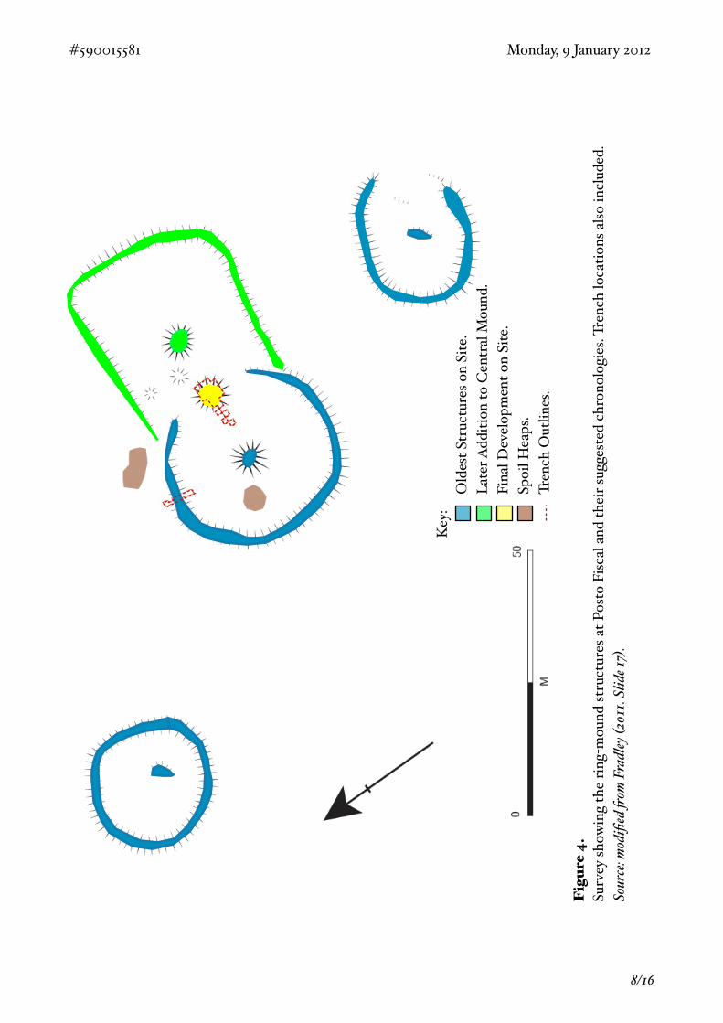
! The importance of extensive surveying in this environment should not be understated and is the reason why surveying was one of the key aims of the 2011 season. By mapping sites over a large area it allows the archaeologist to make connections between sites that may otherwise not have been associated (Fig 5). On a smaller scale, intensive surveying is also very useful. During the dig most of the finds were recorded using the TST or a dumpy level this allowed finds to be placed on the map of the site showing distribution of finds across the whole site.
#590015581! ! ! ! ! ! ! ! ! Monday, 9 January 2012
! 7/16
#590015581! ! ! ! ! ! ! ! ! Monday, 9 January 2012
! 8/16
Key
:!
Old
est S
truc
ture
s on
Site
.!
Late
r Add
ition
to C
entr
al M
ound
.!
Fina
l Dev
elop
men
t on
Site
.!
Spoi
l Hea
ps.
!Tr
ench
Out
lines
.
Fig
ure
4.Su
rvey
show
ing
the
ring-
mou
nd st
ruct
ures
at P
osto
Fisc
al a
nd th
eir s
ugge
sted
chr
onol
ogie
s. Tr
ench
loca
tions
also
incl
uded
.So
urce
: mod
ified
&om
Fra
dley
(201
1. Sl
ide 1
7).
#590015581! ! ! ! ! ! ! ! ! Monday, 9 January 2012
! 9/16
Fig
ure
5.A
n ex
ampl
e of
the
con
nect
ions
bet
ween
indi
vidu
al s
ites
that
can
bec
ome
appa
rent
whe
n lo
oked
at
on a
larg
er s
cale
. Thi
s sh
ows t
hat m
any
sites
cou
ld a
ll be
ass
ocia
ted
to th
e Ave
lino
site.
Sour
ce: F
radl
ey (2
011.
Slid
e 11)
.
PRELIMINARY FINDINGSInitial Thoughts And Interpretations
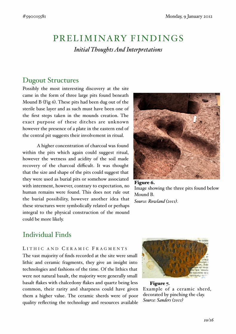
Dugout StructuresPossibly the most interesting discovery at the site came in the form of three large pits found beneath Mound B (Fig 6). These pits had been dug out of the sterile base layer and as such must have been one of the first steps taken in the mounds creation. The exact purpose of these ditches are unknown however the presence of a plate in the eastern end of the central pit suggests their involvement in ritual.
! A higher concentration of charcoal was found within the pits which again could suggest ritual, however the wetness and acidity of the soil made recovery of the charcoal difficult. It was thought that the size and shape of the pits could suggest that they were used as burial pits or somehow associated with interment, however, contrary to expectation, no human remains were found. This does not rule out the burial possibility, however another idea that these structures were symbolically related or perhaps integral to the physical construction of the mound could be more likely.
Individual Finds
L I T H I C A N D C E R A M I C F R A G M E N T S
The vast majority of finds recorded at the site were small lithic and ceramic fragments, they give an insight into technologies and fashions of the time. Of the lithics that were not natural basalt, the majority were generally small basalt flakes with chalcedony flakes and quartz being less common, their rarity and sharpness could have given them a higher value. The ceramic sherds were of poor quality reflecting the technology and resources available
#590015581! ! ! ! ! ! ! ! ! Monday, 9 January 2012
! 10/16
Figure 7.Example of a ceramic sherd, decorated by pinching the clay.Source: Sanders (2011)
Figure 6.Image showing the three pits found below Mound B. Source: Rowland (2011).
to the Taquara/Itararé. They were mostly plain or smoke blackened but several pieces have pinch mark decoration (Fig. 7) similar to the examples given by Schmitz & Becker (2006. p83, p97). The sherds suggest the ceramics would have been small vessels, possibly for drinking. Further analysis needs to be done on the ceramic as previous analysis of phytolith residue can show exactly what the pot was used for (Iriarte, Gillam and Marozzi. 2008)
! The fragments seemed to occur in most layers on the site with no clear grouping apart from an increase of chalcedony flakes and quartz in the central dugout structure. This makes it difficult to say whether the majority of finds had been purposefully deposited at the site for some reason, possibly a ritual dedication, or if they had accumulated over time with repeated usage of the site.
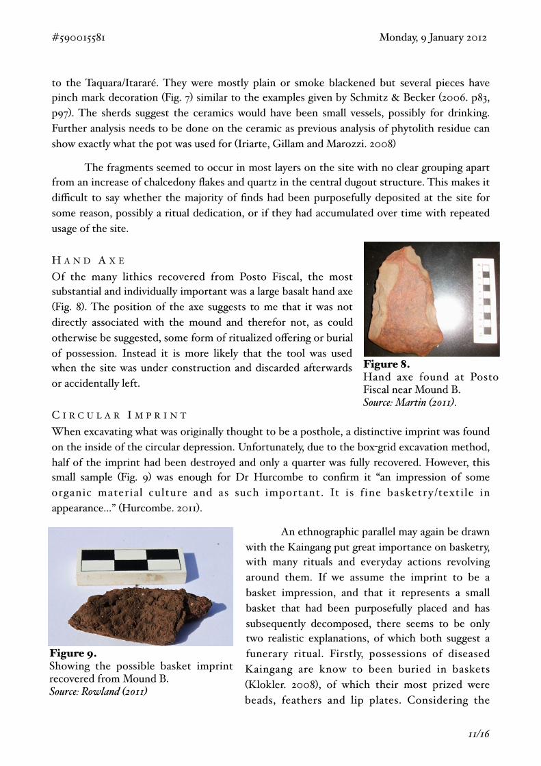
H A N D A X E
Of the many lithics recovered from Posto Fiscal, the most substantial and individually important was a large basalt hand axe (Fig. 8). The position of the axe suggests to me that it was not directly associated with the mound and therefor not, as could otherwise be suggested, some form of ritualized offering or burial of possession. Instead it is more likely that the tool was used when the site was under construction and discarded afterwards or accidentally left.
C I R C U L A R I M P R I N T
When excavating what was originally thought to be a posthole, a distinctive imprint was found on the inside of the circular depression. Unfortunately, due to the box-grid excavation method, half of the imprint had been destroyed and only a quarter was fully recovered. However, this small sample (Fig. 9) was enough for Dr Hurcombe to confirm it “an impression of some organic material culture and as such important. It is f ine basketr y/textile in appearance...” (Hurcombe. 2011).
! An ethnographic parallel may again be drawn with the Kaingang put great importance on basketry, with many rituals and everyday actions revolving around them. If we assume the imprint to be a basket impression, and that it represents a small basket that had been purposefully placed and has subsequently decomposed, there seems to be only two realistic explanations, of which both suggest a funerary ritual. Firstly, possessions of diseased Kaingang are know to been buried in baskets (Klokler. 2008), of which their most prized were beads, feathers and lip plates. Considering the
#590015581! ! ! ! ! ! ! ! ! Monday, 9 January 2012
! 11/16
Figure 8.Hand axe found at Posto Fiscal near Mound B. Source: Martin (2011).
Figure 9.Showing the possible basket imprint recovered from Mound B.Source: Rowland (2011)
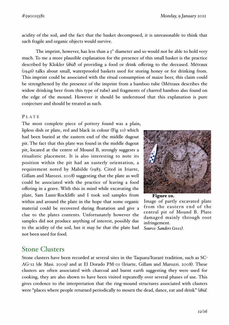
acidity of the soil, and the fact that the basket decomposed, it is unreasonable to think that such fragile and organic objects would survive.
! The imprint, however, has less than a 5" diameter and so would not be able to hold very much. To me a more plausible explanation for the presence of this small basket is the practice described by Klokler (ibid) of providing a food or drink offering to the deceased. Métraux (1946) talks about small, waterproofed baskets used for storing honey or for drinking from. This imprint could be associated with the ritual consumption of maize beer, this claim could be strengthened by the presence of the imprint from a bamboo tube (Métraux describes the widow drinking beer from this type of tube) and fragments of charred bamboo also found on the edge of the mound. However it should be understood that this explanation is pure conjecture and should be treated as such.
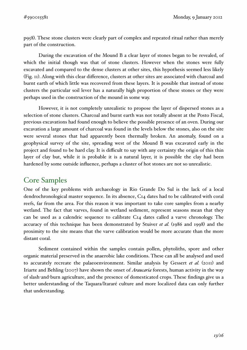
P L A T E
The most complete piece of pottery found was a plain, lipless dish or plate, red and black in colour (Fig 10) which had been buried at the eastern end of the middle dugout pit. The fact that this plate was found in the middle dugout pit, located at the centre of Mound B, strongly suggests a ritualistic placement. It is also interesting to note its position within the pit had an easterly orientation, a requirement noted by Mabilde (1983. Cited in Iriarte, Gillam and Marozzi. 2008) suggesting that the plate as well could be associated with the practice of leaving a food offering in a grave. With this in mind while excavating the plate, Sam Lunn-Rockliffe and I took soil samples from within and around the plate in the hope that some organic material could be recovered during floatation and give a clue to the plates contents. Unfortunately however the samples did not produce anything of interest, possibly due to the acidity of the soil, but it may be that the plate had not been used for food.
Stone ClustersStone clusters have been recorded at several sites in the Taquara/Itararé tradition, such as SC-AG-12 (de Masi. 2009) and at El Dorado PM-01 (Iriarte, Gillam and Marozzi. 2008). These clusters are often associated with charcoal and burnt earth suggesting they were used for cooking, they are also shown to have been visited repeatedly over several phases of use. This gives credence to the interpretation that the ring-mound structures associated with clusters were “places where people returned periodically to mourn the dead, dance, eat and drink” (ibid.
#590015581! ! ! ! ! ! ! ! ! Monday, 9 January 2012
! 12/16
Figure 10.Image of partly excavated plate from the eastern end of the central pit of Mound B. Plate damaged mainly through root infringement.Source: Sanders (2011).
p958). These stone clusters were clearly part of complex and repeated ritual rather than merely part of the construction.
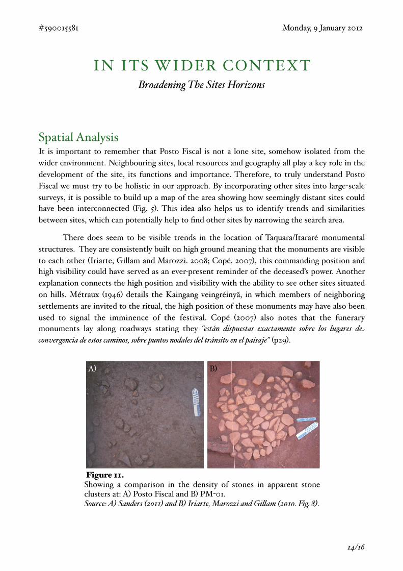
! During the excavation of the Mound B a clear layer of stones began to be revealed, of which the initial though was that of stone clusters. However when the stones were fully excavated and compared to the dense clusters at other sites, this hypothesis seemed less likely (Fig. 11). Along with this clear difference, clusters at other sites are associated with charcoal and burnt earth of which little was recovered from these layers. It is possible that instead of stone clusters the particular soil lever has a naturally high proportion of these stones or they were perhaps used in the construction of the mound in some way.
! However, it is not completely unrealistic to propose the layer of dispersed stones as a selection of stone clusters. Charcoal and burnt earth was not totally absent at the Posto Fiscal, previous excavations had found enough to believe the possible presence of an oven. During our excavation a large amount of charcoal was found in the levels below the stones, also on the site were several stones that had apparently been thermally broken. An anomaly, found on a geophysical survey of the site, spreading west of the Mound B was excavated early in the project and found to be hard clay. It is difficult to say with any certainty the origin of this thin layer of clay but, while it is probable it is a natural layer, it is possible the clay had been hardened by some outside influence, perhaps a cluster of hot stones are not so unrealistic.
Core SamplesOne of the key problems with archaeology in Rio Grande Do Sul is the lack of a local dendrochronological master sequence. In its absence, C14 dates had to be calibrated with coral reefs, far from the area. For this reason it was important to take core samples from a nearby wetland. The fact that varves, found in wetland sediment, represent seasons mean that they can be used as a calendric sequence to calibrate C14 dates called a varve chronology. The accuracy of this technique has been demonstrated by Stuiver et al. (1986 and 1998) and the proximity to the site means that the varve calibration would be more accurate than the more distant coral.
! Sediment contained within the samples contain pollen, phytoliths, spore and other organic material preserved in the anaerobic lake conditions. These can all be analysed and used to accurately recreate the palaeoenvironment. Similar analysis by Gessert et al. (2011) and Iriarte and Behling (2007) have shown the onset of Araucaria forests, human activity in the way of slash-and-burn agriculture, and the presence of domesticated crops. These findings give us a better understanding of the Taquara/Itararé culture and more localized data can only further that understanding.
#590015581! ! ! ! ! ! ! ! ! Monday, 9 January 2012
! 13/16
IN ITS WIDER CONTEXTBroadening The Sites Horizons
Spatial AnalysisIt is important to remember that Posto Fiscal is not a lone site, somehow isolated from the wider environment. Neighbouring sites, local resources and geography all play a key role in the development of the site, its functions and importance. Therefore, to truly understand Posto Fiscal we must try to be holistic in our approach. By incorporating other sites into large-scale surveys, it is possible to build up a map of the area showing how seemingly distant sites could have been interconnected (Fig. 5). This idea also helps us to identify trends and similarities between sites, which can potentially help to find other sites by narrowing the search area.
! There does seem to be visible trends in the location of Taquara/Itararé monumental structures. They are consistently built on high ground meaning that the monuments are visible to each other (Iriarte, Gillam and Marozzi. 2008; Copé. 2007), this commanding position and high visibility could have served as an ever-present reminder of the deceased’s power. Another explanation connects the high position and visibility with the ability to see other sites situated on hills. Métraux (1946) details the Kaingang veingréinyã, in which members of neighboring settlements are invited to the ritual, the high position of these monuments may have also been used to signal the imminence of the festival. Copé (2007) also notes that the funerary monuments lay along roadways stating they “están dispuestas exactamente sobre los lugares de convergencia de estos caminos, sobre puntos nodales del tránsito en el paisaje” (p29).
#590015581! ! ! ! ! ! ! ! ! Monday, 9 January 2012
! 14/16
A) B)
Figure 11.Showing a comparison in the density of stones in apparent stone clusters at: A) Posto Fiscal and B) PM-01.Source: A) Sanders (2011) and B) Iriarte, Marozzi and Gi$am (2010. Fig. 8).
! Spatial analysis also suggests that the ring-mound structures are often associated with Pit House Villages. The ring-mounds are often associated with a Pit House Village, from which the deceased would probably have been from. While Posto Fiscal has not been formally associated with a specific settlement, the Pit House Village at Avelino is relatively close, however the Museum Pit House Village is also fairly close and it would not be unthinkable to claim association with either. Pit House Villages also seem to often be linked with areas of wetland which could have acted as the water supply, especially if what are now wetlands were at the time lakes.
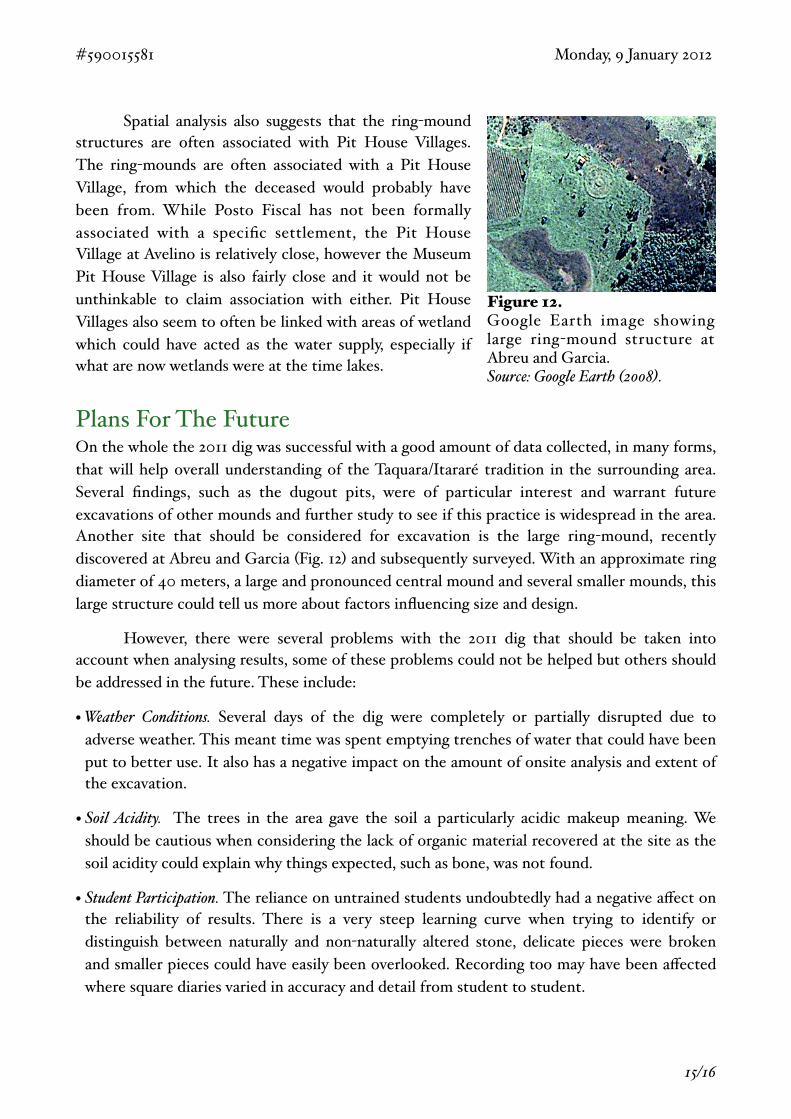
Plans For The FutureOn the whole the 2011 dig was successful with a good amount of data collected, in many forms, that will help overall understanding of the Taquara/Itararé tradition in the surrounding area. Several findings, such as the dugout pits, were of particular interest and warrant future excavations of other mounds and further study to see if this practice is widespread in the area. Another site that should be considered for excavation is the large ring-mound, recently discovered at Abreu and Garcia (Fig. 12) and subsequently surveyed. With an approximate ring diameter of 40 meters, a large and pronounced central mound and several smaller mounds, this large structure could tell us more about factors influencing size and design.
! However, there were several problems with the 2011 dig that should be taken into account when analysing results, some of these problems could not be helped but others should be addressed in the future. These include:
• Weather Conditions. Several days of the dig were completely or partially disrupted due to adverse weather. This meant time was spent emptying trenches of water that could have been put to better use. It also has a negative impact on the amount of onsite analysis and extent of the excavation.
• Soil Acidity. The trees in the area gave the soil a particularly acidic makeup meaning. We should be cautious when considering the lack of organic material recovered at the site as the soil acidity could explain why things expected, such as bone, was not found.
• Student Participation. The reliance on untrained students undoubtedly had a negative affect on the reliability of results. There is a very steep learning curve when trying to identify or distinguish between naturally and non-naturally altered stone, delicate pieces were broken and smaller pieces could have easily been overlooked. Recording too may have been affected where square diaries varied in accuracy and detail from student to student.
#590015581! ! ! ! ! ! ! ! ! Monday, 9 January 2012
! 15/16
Figure 12.Google Earth image showing large ring-mound structure at Abreu and Garcia.Source: Google Earth (2008).
BIBLIOGRAPHYAlcoa, 2012. Barra Grande Hydroelectric Power Station: Energy Fo r D e v e l o p m e n t. [Onl ine ] Ava i l ab le a t : <http : / /w w w. a l c o a . c o m / b r a z i l / e n / c u s t o m _ p a g e /environment_barra_grande.asp> [Accessed 9 January 2012].
Beber, M. V., 2004. “O Sisteme De Assentamento Dos Grupos Ceramistas Do Planalto Sul-Brasileiro: O Caso Da Tradição Taquara/Itararé.” PhD Thesis, Universidade do Vale do Rio dos Sinos.
Copé, S. M., 2007. El Uso De La Arquitectura Como Artefacto En El Estudio De Paisajes Arqueológicos Del Altiplanto Sur Brasileño, Rio Grande Do Sul. Revista de Arqueologia. 2: 15-34.
Davis, I., 1968. Some Macro-Jê Relationships. International Journal of American Linguistics. 34(1): 42-47.
Delle, J. A. et al., 2003. On Collaboration, Class Conflict and Archaeology in Brazil. International Journal of Historical Archaeology. 7(3): 223-237.
De Masi, M. A. N., 2009. Centrol Cerimoniais Do Planalto Meridional: Umaanálise Intrasítio. Revista de Arqueologia. 22(1): 99-113.
De Souza, J. G., 2011. Linguistics, Archaeology, and the Histories of Language Spread: The Case of the Southern Jê Languages, Brazil. Cadernos de Etnolingüística. 3(2): 1-16.
Fradley, M., 2011. Pinhal Da Serra. [Presentation] (Personal communication, 28 October 2011).
Funari, P. P. A., 2002. Class Interests in Brazilian Archaeology. International Journal of Historical Archaeology. 5(3): 209-216.
Gessert , S. , 2011 . Late Holocene vegetation and environmental dynamics of the Araucaria forest region in Misiones Province, NE Argentina. Review of Palaeobotany and Palynology. 166(1-2): 29-37.
Gippert, J., 1993. Languages of South America. [Online Map] Available at: <http://titus.uni-frankfurt.de/didact/karten/amer/samerim.htm> [Accessed 19 January 2012].
Google Earth., 2008. Abreu & Garcia 27°40'13.48"S, 50°44'25.95"O, elevation 878M. Available through:<http://www.google.com/earth/index.html> [Accessed 13 January 2011].
Hurcombe, L., 2011. Regarding The Potential Fabric Impressions. [e-mail] (Personal communication, 3 November 2011).
Iriarte, J., and Behling, H., 2007. The Expansion of Araucaria Forest in the Southern Brazilian Highlands During the Last 4000 Years and its Implications For the De ve lopment o f the Taquara /Ita ra ré Trad i t ion . Environmental Archaeology. 12(2): 115-127.
Iriarte, J., Gillam, J. C. and Marozzi, O., 2008. Monumental Burials and Memorial Feasting: An Example From the Southern Brazilian Highlands. Antiquity. 82: 947-961.
Iriarte, J., Marozzi, O. and Gillam, J. C., 2010. Monumentos Funerarios Y Festejos Rituales: Complejos De Recintos Y Túmulos Taquara/Itararé En ElDorado, Misiones (Argentina). Arqueologia Iberoamericana. 6: 25-38
Klokler, D. M., 2008. “Food for body and soul: Mortuary ritual in shell mounds (Laguna - Brazil)” PhD Thesis, University of Arizona.
Martin, C., 2011. Photos From Posto Fiscal. [Photographs] (Campbell Martin’s Private Collection)
Meggers, J., 1985. Advances in Brazilian Archeology, 1935-1985. American Antiquity. 50(2): 364-373.
Métraux, A., 1946. The Caingang. In: J. H. Steward ed. 1946. Handbook of South American Indians: Volume 1. Washington: Smithsonian Institute. 445-475.
Noelli, F. S., 2005. Rethinking Stereotypes and the History of Research on Je Populations in South Brazil. In: P. P. Funari, A. Zarankin and E. Stovel eds. 2005. Global Archaeological Theory: Contextual Voices and Contemporary Thoughts. New York: Kluwer Academic/Plenum Publishers. Ch. 11.
Rowland, H., 2011. Brazil 2011. [Photographs] (Huw Rowland’s Personal Collection).
Sanders, E., 2011. Photos From Brazil. [Photographs] (Emily Sander’s Personal Collection).
Schmitz, P. I. and Becker, I. I. B., 2006.Os Primitivos Engenheiros do Planalto e Suas Estruturas Subterrâneas: A Tradição Taquara. In: P. I. Schmitz ed. Pré-História do Rio Grande do Sul. Instituto Anchietano de Pesquisas: São Leopoldo. Ch. 3.
Stuiver, M. et al., 1986. Radiocarbon Age Calibration Back To 13,300 Years BP And The 14C Age Matching Of The German Oak And US Bristlecone Pine Chronologies. 28(2B): 969-979.
Stuiver, M. et al., 1998. INTCAL98 Radiocarbon Age Calibration, 24,000-0 Cal. BP. Radiocarbon. 40(3): 1041-1083.
Wenner-Gren., 2010. Grantees: Iriarte, Jose A. [Online] Available at: <http://www.wennergren.org/grantees/iriarte-jose-a> [Accessed 9 January 2012].
Wikipedia., 2011a. Pinhal Da Serra. [Image Online] Available at: <http://pt.wikipedia.org/wiki/Pinhal_da_Serra> [Accessed 19 January 2012].
Wikipedia., 2011b. Jê Language Group Map. [Image Online] Available at: <http://en.wikipedia.org/wiki/File:Macro-Ge_languages.png> [Accessed 19 January 2012].
#590015581! ! ! ! ! ! ! ! ! Monday, 9 January 2012
! 16/16
Recommended