APPENDIX 5.15A
Preliminary Stormwater Management Design
CPV VACA STATION POND HYDROLOGY CALCULATIONS
Prepared by:
Vincent A. Bossi
Reviewed by: Allan F. Haddox, II
PEI# 271120
June 4, 2008
Hydraflow Table of Contents Proposed pond 4-16-08.gpw
Hydraflow Hydrographs Extension for AutoCAD® Civil 3D® 2008 by Autodesk, Inc. v6.052 Wednesday, Jun 4, 2008
Watershed Model Schematic .................................................................................... 1
2 - Year Summary Report ....................................................................................................................... 2Hydrograph Reports ................................................................................................................. 3
Hydrograph No. 1, Rational, Proposed site ............................................................................ 3Hydrograph No. 2, Reservoir, Route to pond ......................................................................... 4
Pond Report - Proposed pond ........................................................................................... 5
10 - Year Summary Report ....................................................................................................................... 6Hydrograph Reports ................................................................................................................. 7
Hydrograph No. 1, Rational, Proposed site ............................................................................ 7Hydrograph No. 2, Reservoir, Route to pond ......................................................................... 8
100 - Year Summary Report ....................................................................................................................... 9Hydrograph Reports ............................................................................................................... 10
Hydrograph No. 1, Rational, Proposed site .......................................................................... 10Hydrograph No. 2, Reservoir, Route to pond ....................................................................... 11
IDF Report ................................................................................................................ 12
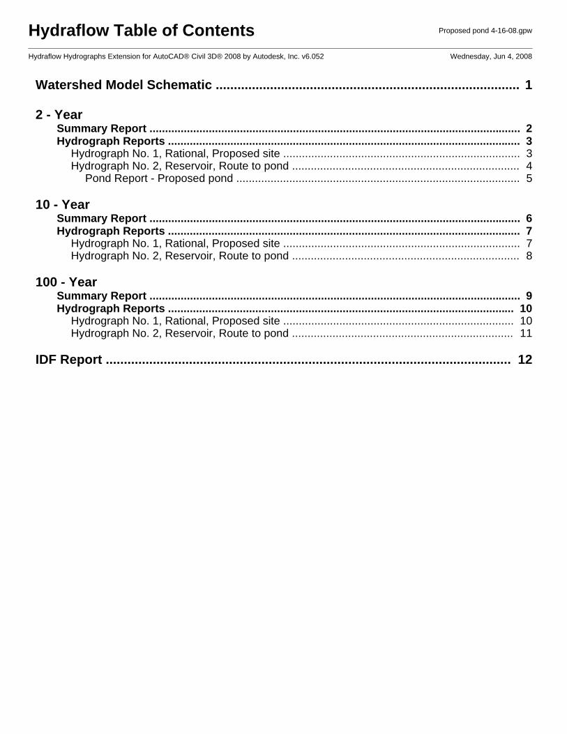
1
2
1
Watershed Model SchematicHydraflow Hydrographs Extension for AutoCAD® Civil 3D® 2008 by Autodesk, Inc. v6.052
Project: Proposed pond 4-16-08.gpw Wednesday, Jun 4, 2008
Hyd. Origin Description
Legend
1 Rational Proposed site 2 Reservoir Route to pond

Hydrograph Summary Report2
Hyd. Hydrograph Peak Time Time to Hyd. Inflow Maximum Total HydrographNo. type flow interval peak volume hyd(s) elevation strge used description
(origin) (cfs) (min) (min) (cuft) (ft) (cuft)
1 Rational 17.09 1 30 30,753 ------ ------ ------ Proposed site
2 Reservoir 0.000 1 n/a 0 1 60.23 30,753 Route to pond
Proposed pond 4-16-08.gpw Return Period: 2 Year Wednesday, Jun 4, 2008
Hydraflow Hydrographs Extension for AutoCAD® Civil 3D® 2008 by Autodesk, Inc. v6.052
Hydrograph ReportHydraflow Hydrographs Extension for AutoCAD® Civil 3D® 2008 by Autodesk, Inc. v6.052 Wednesday, Jun 4, 2008
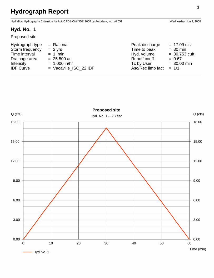
Hyd. No. 1 Proposed site
Hydrograph type = Rational Peak discharge = 17.09 cfsStorm frequency = 2 yrs Time to peak = 30 minTime interval = 1 min Hyd. volume = 30,753 cuftDrainage area = 25.500 ac Runoff coeff. = 0.67Intensity = 1.000 in/hr Tc by User = 30.00 minIDF Curve = Vacaville_ISO_22.IDF Asc/Rec limb fact = 1/1
3
0 10 20 30 40 50 60
Q (cfs)
0.00 0.00
3.00 3.00
6.00 6.00
9.00 9.00
12.00 12.00
15.00 15.00
18.00 18.00
Q (cfs)
Time (min)
Proposed siteHyd. No. 1 -- 2 Year
Hyd No. 1
Hydrograph ReportHydraflow Hydrographs Extension for AutoCAD® Civil 3D® 2008 by Autodesk, Inc. v6.052 Wednesday, Jun 4, 2008
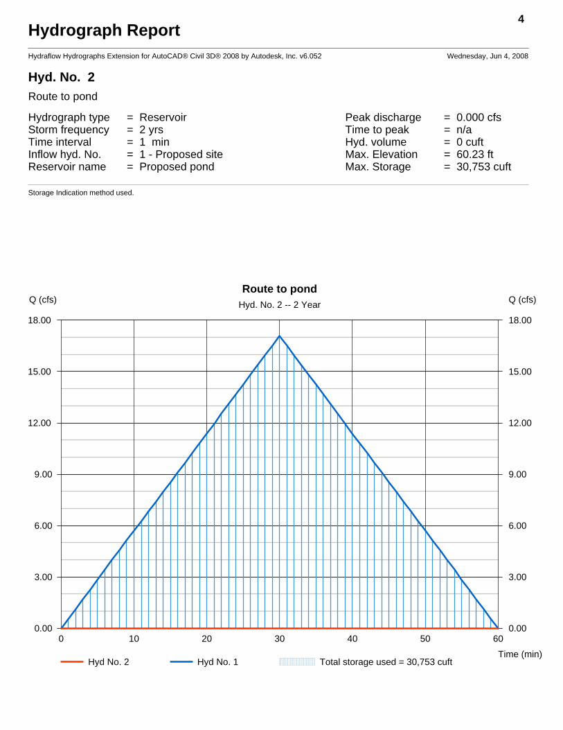
Hyd. No. 2 Route to pond
Hydrograph type = Reservoir Peak discharge = 0.000 cfsStorm frequency = 2 yrs Time to peak = n/aTime interval = 1 min Hyd. volume = 0 cuftInflow hyd. No. = 1 - Proposed site Max. Elevation = 60.23 ftReservoir name = Proposed pond Max. Storage = 30,753 cuft
Storage Indication method used.
4
0 10 20 30 40 50 60
Q (cfs)
0.00 0.00
3.00 3.00
6.00 6.00
9.00 9.00
12.00 12.00
15.00 15.00
18.00 18.00
Q (cfs)
Time (min)
Route to pondHyd. No. 2 -- 2 Year
Hyd No. 2 Hyd No. 1 Total storage used = 30,753 cuft
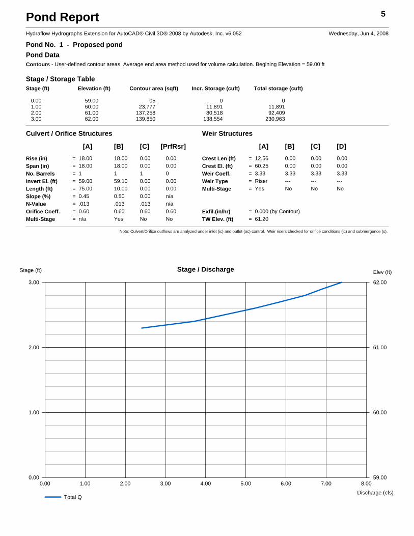
Pond Report 5
Hydraflow Hydrographs Extension for AutoCAD® Civil 3D® 2008 by Autodesk, Inc. v6.052 Wednesday, Jun 4, 2008
Pond No. 1 - Proposed pondPond DataContours - User-defined contour areas. Average end area method used for volume calculation. Begining Elevation = 59.00 ft
Stage / Storage TableStage (ft) Elevation (ft) Contour area (sqft) Incr. Storage (cuft) Total storage (cuft)
0.00 59.00 05 0 01.00 60.00 23,777 11,891 11,8912.00 61.00 137,258 80,518 92,4093.00 62.00 139,850 138,554 230,963
Culvert / Orifice Structures Weir Structures
[A] [B] [C] [PrfRsr] [A] [B] [C] [D]Rise (in) = 18.00 18.00 0.00 0.00Span (in) = 18.00 18.00 0.00 0.00No. Barrels = 1 1 1 0Invert El. (ft) = 59.00 59.10 0.00 0.00Length (ft) = 75.00 10.00 0.00 0.00Slope (%) = 0.45 0.50 0.00 n/aN-Value = .013 .013 .013 n/aOrifice Coeff. = 0.60 0.60 0.60 0.60Multi-Stage = n/a Yes No No
Crest Len (ft) = 12.56 0.00 0.00 0.00Crest El. (ft) = 60.25 0.00 0.00 0.00Weir Coeff. = 3.33 3.33 3.33 3.33Weir Type = Riser --- --- ---Multi-Stage = Yes No No No
Exfil.(in/hr) = 0.000 (by Contour)TW Elev. (ft) = 61.20
Note: Culvert/Orifice outflows are analyzed under inlet (ic) and outlet (oc) control. Weir risers checked for orifice conditions (ic) and submergence (s).
0.00 1.00 2.00 3.00 4.00 5.00 6.00 7.00 8.00
Stage (ft)
0.00 59.00
1.00 60.00
2.00 61.00
3.00 62.00
Elev (ft)
Discharge (cfs)
Stage / Discharge
Total Q

Hydrograph Summary Report6
Hyd. Hydrograph Peak Time Time to Hyd. Inflow Maximum Total HydrographNo. type flow interval peak volume hyd(s) elevation strge used description
(origin) (cfs) (min) (min) (cuft) (ft) (cuft)
1 Rational 26.31 1 30 47,360 ------ ------ ------ Proposed site
2 Reservoir 0.000 1 n/a 0 1 60.44 47,360 Route to pond
Proposed pond 4-16-08.gpw Return Period: 10 Year Wednesday, Jun 4, 2008
Hydraflow Hydrographs Extension for AutoCAD® Civil 3D® 2008 by Autodesk, Inc. v6.052
Hydrograph ReportHydraflow Hydrographs Extension for AutoCAD® Civil 3D® 2008 by Autodesk, Inc. v6.052 Wednesday, Jun 4, 2008
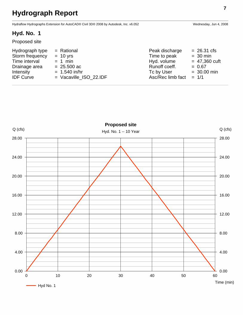
Hyd. No. 1 Proposed site
Hydrograph type = Rational Peak discharge = 26.31 cfsStorm frequency = 10 yrs Time to peak = 30 minTime interval = 1 min Hyd. volume = 47,360 cuftDrainage area = 25.500 ac Runoff coeff. = 0.67Intensity = 1.540 in/hr Tc by User = 30.00 minIDF Curve = Vacaville_ISO_22.IDF Asc/Rec limb fact = 1/1
7
0 10 20 30 40 50 60
Q (cfs)
0.00 0.00
4.00 4.00
8.00 8.00
12.00 12.00
16.00 16.00
20.00 20.00
24.00 24.00
28.00 28.00
Q (cfs)
Time (min)
Proposed siteHyd. No. 1 -- 10 Year
Hyd No. 1
Hydrograph ReportHydraflow Hydrographs Extension for AutoCAD® Civil 3D® 2008 by Autodesk, Inc. v6.052 Wednesday, Jun 4, 2008
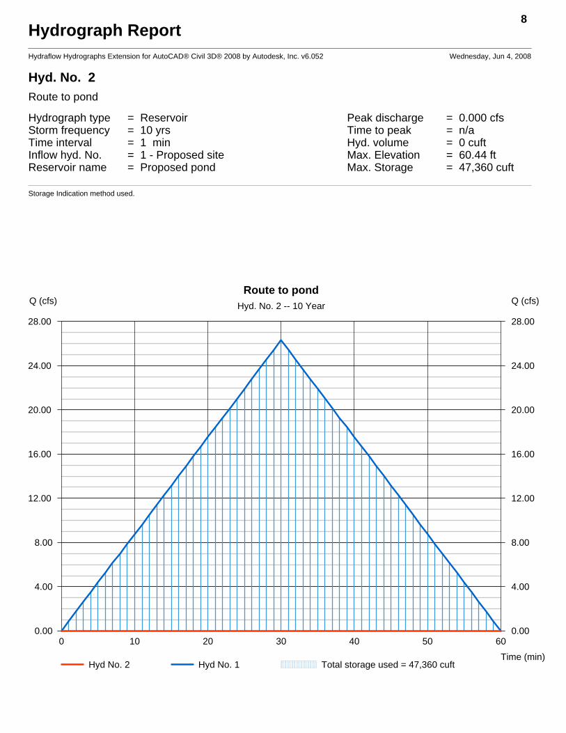
Hyd. No. 2 Route to pond
Hydrograph type = Reservoir Peak discharge = 0.000 cfsStorm frequency = 10 yrs Time to peak = n/aTime interval = 1 min Hyd. volume = 0 cuftInflow hyd. No. = 1 - Proposed site Max. Elevation = 60.44 ftReservoir name = Proposed pond Max. Storage = 47,360 cuft
Storage Indication method used.
8
0 10 20 30 40 50 60
Q (cfs)
0.00 0.00
4.00 4.00
8.00 8.00
12.00 12.00
16.00 16.00
20.00 20.00
24.00 24.00
28.00 28.00
Q (cfs)
Time (min)
Route to pondHyd. No. 2 -- 10 Year
Hyd No. 2 Hyd No. 1 Total storage used = 47,360 cuft
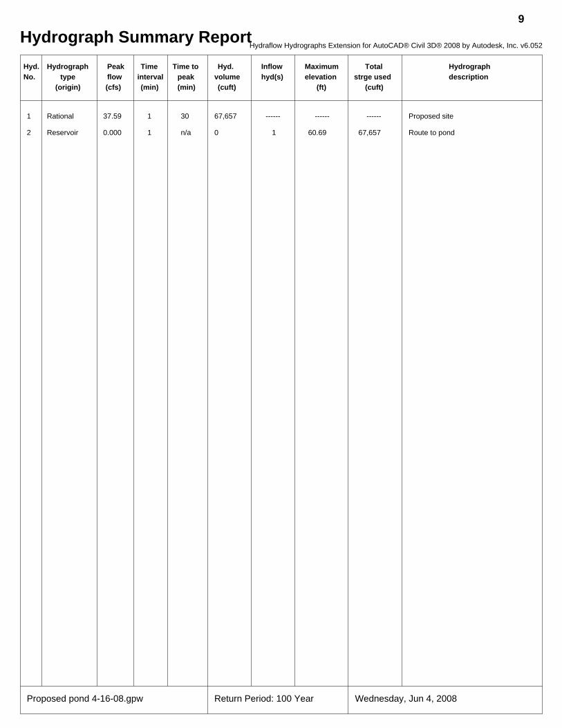
Hydrograph Summary Report9
Hyd. Hydrograph Peak Time Time to Hyd. Inflow Maximum Total HydrographNo. type flow interval peak volume hyd(s) elevation strge used description
(origin) (cfs) (min) (min) (cuft) (ft) (cuft)
1 Rational 37.59 1 30 67,657 ------ ------ ------ Proposed site
2 Reservoir 0.000 1 n/a 0 1 60.69 67,657 Route to pond
Proposed pond 4-16-08.gpw Return Period: 100 Year Wednesday, Jun 4, 2008
Hydraflow Hydrographs Extension for AutoCAD® Civil 3D® 2008 by Autodesk, Inc. v6.052

Hydrograph ReportHydraflow Hydrographs Extension for AutoCAD® Civil 3D® 2008 by Autodesk, Inc. v6.052 Wednesday, Jun 4, 2008
Hyd. No. 1 Proposed site
Hydrograph type = Rational Peak discharge = 37.59 cfsStorm frequency = 100 yrs Time to peak = 30 minTime interval = 1 min Hyd. volume = 67,657 cuftDrainage area = 25.500 ac Runoff coeff. = 0.67Intensity = 2.200 in/hr Tc by User = 30.00 minIDF Curve = Vacaville_ISO_22.IDF Asc/Rec limb fact = 1/1
10
0 10 20 30 40 50 60
Q (cfs)
0.00 0.00
10.00 10.00
20.00 20.00
30.00 30.00
40.00 40.00
Q (cfs)
Time (min)
Proposed siteHyd. No. 1 -- 100 Year
Hyd No. 1
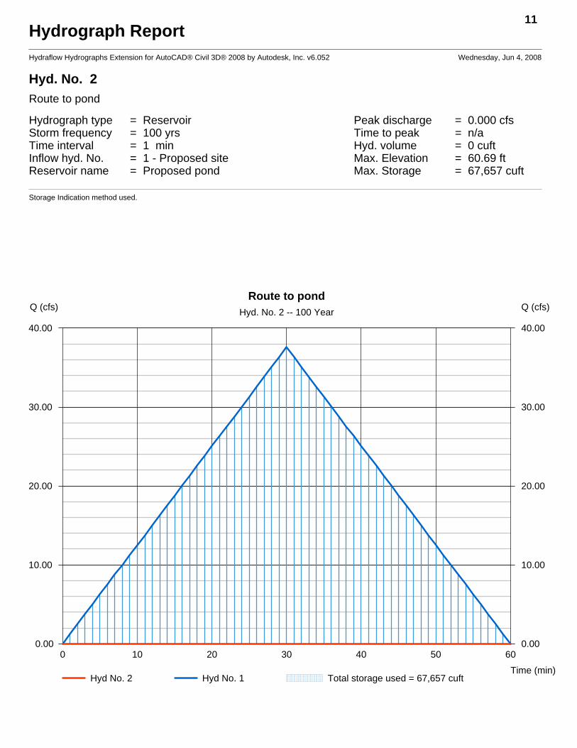
Hydrograph ReportHydraflow Hydrographs Extension for AutoCAD® Civil 3D® 2008 by Autodesk, Inc. v6.052 Wednesday, Jun 4, 2008
Hyd. No. 2 Route to pond
Hydrograph type = Reservoir Peak discharge = 0.000 cfsStorm frequency = 100 yrs Time to peak = n/aTime interval = 1 min Hyd. volume = 0 cuftInflow hyd. No. = 1 - Proposed site Max. Elevation = 60.69 ftReservoir name = Proposed pond Max. Storage = 67,657 cuft
Storage Indication method used.
11
0 10 20 30 40 50 60
Q (cfs)
0.00 0.00
10.00 10.00
20.00 20.00
30.00 30.00
40.00 40.00
Q (cfs)
Time (min)
Route to pondHyd. No. 2 -- 100 Year
Hyd No. 2 Hyd No. 1 Total storage used = 67,657 cuft
Recommended


![Acad Civil3d08 Hydraflow Storm Sewers Whitepaper Final[1]](https://img.pdfslide.us/doc/110x75/5571fcd44979599169980466/acad-civil3d08-hydraflow-storm-sewers-whitepaper-final1.jpg)
![Hydrographs[Date] Today I will: - Be able to construct and understand flood hydrographs](https://img.pdfslide.us/doc/110x75/56813b43550346895da41aa0/hydrographsdate-today-i-will-be-able-to-construct-and-understand-flood.jpg)