GLIMS
HIGH ICE
Annual satellite imaging of the world’s glaciersAssessment of glacier extent and change
Development and population of a digital glacier data inventory

Skeletal remains of what was a debris-covered glacier near Mt. Everest
J.S. Kargel, April 2001


Global Land Ice Measurements from Space
GLIMS primary goal: to determine the extent of Earth’s glaciers and the rate at which they are changing.
RESULTS:– Acquired >30,000 ASTER L1A scenes (of any quality)
• Of these, we’ve archived and distributed over 5000 L1B scenes with:– Nominal gain settings and seasons for best snow and ice imaging– GLIMS uses all ASTER bands (VNIR,SWIR,TIR) for glacier mapping
• Timely ASTER imaging response to recent glacier hazard events– Purchased 150+ Landsat ETM+ scenes for RC ftp download– Currently producing digital maps of glacier change
• 23 regional centers mapping current extent of exposed land ice• Producing high resolution surface displacement fields using ASTER• Automating data extraction from ASTER• Measuring glacier lake temperature variations using multi TIR bands
– Designed GIS digital database for GLIMS glacier inventory (NSIDC)
www.GLIMS.orgwww.GLIMS.org

GLIMS Regions and Regional Centers
•GLIMS is an international consortium of 23 regional centers•Coordinated by U.S. Geological Survey - Flagstaff

Variability Forcing Response Consequence Prediction
Precipitation, evaporation &
cycling of water changing?
Global ocean circulation varying?
Global ecosystems changing?
Stratospheric ozone changing?
Ice cover mass changing?
Motions of Earth & interior
processes?
Atmospheric constituents &
solar radiation on climate?
Changes in land cover
& land use?
Surface transformation?
Clouds & surface hydrological processes on
climate?
Ecosystem responses &
affects on global carbon cycle?
Changes in global ocean circulation?
Stratospheric trace constituent
responses?
Sea level affected by
climate change?
Pollution effects?
Weather variation related
to climate variation?
Consequences in land cover & land use?
Coastal region change?
Weather forecasting
improvement?
Transient climate
variations?
Trends in long-term climate?
Future atmospheric
chemical impacts?
Future concentrations of
carbon dioxide and methane?
Science Questions from the Research Strategy
*
*
*
*
* *
**
*

Glacier Relevance to other Science Questions• R1. Clouds and surface hydrological processes on climate?
– Albedo feedbacks; thermohaline circulation of oceans.• R3. Changes in global ocean circulation?
– Thermohaline circulation.• C3. Coastal region change?
– Glacier/ice sheets are melting: effects on sea level.• V1. Precipitation, evaporation, and cycling water?
– Glaciers/ice sheets store most of Earth’s fresh water.• F2. Changes in land cover and land use?
– Changing glacier cover changes water availability, hence land use in areas downstream.• F3. Surface transformation?
– Glacial isostacy/rebound and mountain uplift/erosion affect glacier stability.• R5. Sea level affected by climate change?
– Climate change alters land ice volume and ocean volume. • C1. Weather variation related to climate variation?
– Albedo and humidity feedbacks due to land ice.• P3. Trends in long-term climate change?
– Glaciers integrate climate signals in continental regions where other climate records may be lacking.

Glaciers in the context of 12 major national research applications
Major research applications
Potentially significant research applications
Major Glacier Applications among 12 U.S. National Research Applications:
• Energy Forecasting: Energy for U.S. Northwest derived partly from hydropower.
• Community disaster preparedness: Mt Rainer/Tacoma; Alaska.
• Water management: Washington and Oregon partly dependent on glacier meltwater (especially Canadian glacier sources)
• Agricultural competitiveness: Dependent on water resources, including glacier meltwater (especially Canadian glacier sources)
• Coastal management: Sea level issues related to global melting of glaciers and ice sheets.
Every U.S. research application has an international dimension and specifically an application in nations of High Asia. Glacier applications to energy, agriculture, and water management are oforder magnitude greater importance to High Asia than to U.S.The issues are of critical economic interest to several nations, andhence, to regional and U.S. national security interests.

Science of glaciers

Science and impacts of glaciers
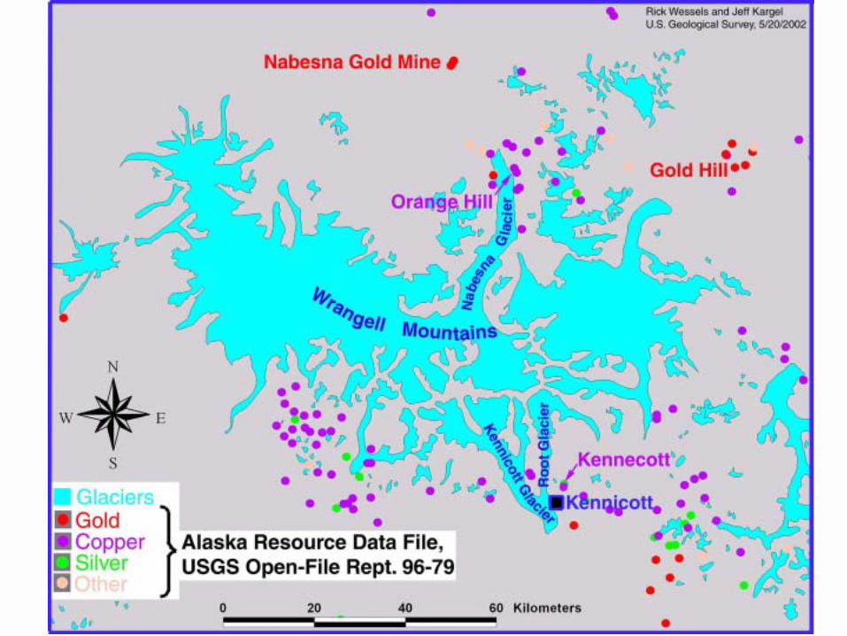
Alaska Mineral resources

Kolka Glacier disaster - ASTER rapid response
From: Kääb, Wessels, Haeberli, Huggel, Kargel, and Singh Khalsa. Rapid ASTER imaging facilitates timely assessment of glacier hazards and disasters, in press, EOS

Kolka Glacier disaster
• 80 million cubic meter rock/ice avalanche and subsequent debris/mud flows on September 20, 2002
• Overran Karmadon village 18 km down valley
• Over 120 killed• Mudflow continued 15km
further down valley• Rapid ASTER imaging
response over several days following emergency.
• ASTER data used by emergency response teams

GLOF-wrecked bridge and replacement near Nepal/China border

Tsho Rolpa, Nepal, GLOF threat and engineering mediation
Credit: ICIMOD

Glacier impact on regional water resources
Hindu Kush Himalaya Glaciers
Fast glacier recession and wasting through most of the region
Impacts on South and Central Asia
500 million people partly depend on glacial meltwater

Gangotri Glacier, India

A. Kääb / University of Zurich
Silty Lake
Himalaya-Tibet: Auto correlated velocity measurments from two high res. ASTER images.
ASTER L1B 321 RGB

Himalayas Bhutan - Tibet
A. Kääb / University of Zurich
ASTER L1B 321 RGB

Glacier Hazard Monitoring and Response: Ice Dam Threatnorth
ASTER
L1B 321R
GB
2001 Dec. 28
Recommended