Strategic Development Plan (SDP) for
Ravi Riverfront Urban Development Project
Environmental Impact Assessment (EIA) Report
Section - 9: Conclusions and Recommendations 237
ANNEXURE – 1: ECOLOGICAL IMPACT
STUDY

Ecological Impact Study
STRATEGIC DEVELOPMENT PLAN (SDP)
FOR
RAVI RIVERFRONT URBAN DEVELOPMENT PROJECT
January-2021
Strategic Development Plan (SDP) for
Ravi Riverfront Urban Development Project
Ecological Impact Study
Table of Contants TOC-I
TABLE OF CONTANTS
EXECUTIVE SUMMARY ......................................................................................................... 1
SECTION - 1: INTRODUCTION ....................................................................................... 1
1.1 Objectives of the Ecological Impact Assessment Study ...... 1
1.2 Methodology to conduct Ecological Impact Assessment... 1
1.3 Legislation and Guidelines ..................................................... 1
1.4 Study Team .............................................................................. 3
SECTION - 2: OBSERVATIONS AND INTERPRETATIONS................................................. 1
2.1 Section-1 Ecological Baseline Study of the project .............. 1
2.1.1 Project Study Area................................................................... 1
2.1.2 Steps in Ecological baseline study ......................................... 2
2.2 Section-2 Ecological Mapping of the Study Area .............. 51
2.3 Section-3 Assessment of Ecological Impacts from the
Development in the project area ........................................ 53
2.3.1 Construction impacts ............................................................ 53
2.3.2 Operational impacts ............................................................. 58
2.4 Section –4 Mitigation Measures ............................................ 62
2.4.1 Impact avoiding/minimizing ................................................. 62
2.4.2 Restoration and Compensation ........................................... 63
SECTION - 3: CONCLUSION AND RECOMMENDATIONS .......................................... 65
Strategic Development Plan (SDP) for
Ravi Riverfront Urban Development Project
Ecological Impact Study
Appendices: TOC-II
APPENDICES:
Appendix-1: Appendices of CITES ................................................................................. 68
Appendix-2: Punjab Wildlife Act (amendments) 2007 ................................................. 71
Appendix 3: List of plant species recommended to be planted on riverbank.......... 76
Appendix 4: List of trees for buffer zones and roadside ............................................... 81
Appendix 5: List of Palms, Gymnosperms, shrubs and ferns for Parks and Gardens .. 83

Strategic Development Plan (SDP) for
Ravi Riverfront Urban Development Project
Ecological Impact Study
List of Tables: TOC-III
LIST OF TABLES:
Table 1-1: Ecology Study Team .................................................................................... 3
Table 2-1: GIS based estimated existing landuses with their areas within the
project site. ................................................................................................... 2
Table 2-2: Criteria used for evaluating a site/habitat. ............................................... 3
Table 2-3: Criteria for evaluating species found within a habitat ............................. 4
Table 2-4: Evaluating the significance of an ecological impact. ............................. 4
Table 2-5: Details of the forest areas within the project boundary. .......................... 5
Table 2-6: Evaluation of forests in the Project area .................................................. 10
Table 2-7: Evaluation of low-lying grassland in the Project area ............................ 11
Table 2-8: Evaluation of Agricultural fields in the Project area ................................ 12
Table 2-9: Evaluation of orchards in the Project area .............................................. 13
Table 2-10: Evaluation of ponds in the Project area. ................................................. 14
Table 2-11: Evaluation of River in the Project area .................................................... 15
Table 2-12: Evaluation of Islands in the Project area ................................................. 16
Table 2-13: Evaluation of wastelands in the Project area ......................................... 17
Table 2-14: List of plant species collected from ponds and river in the project area.
.................................................................................................................... 18
Table 2-15: List of plant species collected from different habitats in the project
area. ........................................................................................................... 19
Table 2-16: Status of plant species recorded within the study area ......................... 31
Table 2-17: List of mammals, birds, reptiles and amphibians of the project area ... 34
Table 2-18: Species richness of fauna and flora of the habitat types in the study
area. ........................................................................................................... 39
Table 2-19: List of insect species identified in different habitats................................ 40
Table 2-20: List of zooplanktons and protoctists found in the ponds and river of the
study area .................................................................................................. 42
Table 2-21: List of the fish species found in the river Ravi. .......................................... 43
Table 2-22: Status of Mammals Species recorded within the Study Area ................ 50
Table 2-23: Status of Amphibian Species recorded within the Study Area .............. 50
Table 2-24: Status of Reptile Species recorded within the Study Area. .................... 50
Table 2-25: Status of Birds Species recorded within the Study Area ......................... 51
Strategic Development Plan (SDP) for
Ravi Riverfront Urban Development Project
Ecological Impact Study
List of Tables: TOC-IV
Table 2-26: Human Impacts on River Ecosystem. ....................................................... 53
Table 2-27: In-depth Impacts of Riverfront Development on Ecological Resources
of the River Ravi ......................................................................................... 61
Table 3-1: Visiting season of the migratory birds found at the project site............. 66
Strategic Development Plan (SDP) for
Ravi Riverfront Urban Development Project
Ecological Impact Study
List of Figures TOC-V
LIST OF FIGURES
Figure 2-1: Map of the Project area showing the locations of ecological study sites
...................................................................................................................... 1
Figure 2-2: GIS based estimation of the forest areas in the project ........................... 7
Figure 2-3: GIS based estimation of the forest areas affected by channel widening
of River Ravi after development. ............................................................... 9
Figure 2-4 (a): Birds of the study area ......................................................................... 44
Figure 2-5 (b): Birds of the study area ......................................................................... 45
Figure 2-6 (c): Birds of the study area ......................................................................... 46
Figure 2-7 (d): Birds of the study area ......................................................................... 47
Figure 2-8: Mammals of the studuy area ................................................................... 48
Figure 2-9: Reptiles and Amphibians of the study area ............................................ 49
Figure 2-10: Biodiversity map of the protected species and their linkage with their
habitats....................................................................................................... 52
Figure 2-11: Simplified Food web in the Project Area. ................................................ 52
Figure 2-12: Ecological and astronomical light pollution (Longcore and Rich 2004).
.................................................................................................................... 60
Figure 3-1: Fixtures that enhance and reduce light pollution .................................. 69
Figure 3-2: Proper installation of fixtures can save energy and reduce light
pollution http://physics.fau.edu/observatory/lightpol-prevent.html .... 70
Figure 3-3: Kites diving to get sacrificial meat at Shahdara Bridge. ........................ 71
Figure 3-4: People selling and buying sacrificial meat at Shahdara Bridge. .......... 71
Figure 3-5A: Spotlight on building height and bird migration (San Francisco
Planning Department 2011) ...................................................................... 73
Figure 3-6B: Portion of the buildings most susceptible to bird strikes. (San Francisco
Planning Department 2011) ...................................................................... 74
Figure 3-7: Bird scaring devices (a) spikes, (b) flex track, (c) net ............................. 75
Strategic Development Plan (SDP) for
Ravi Riverfront Urban Development Project
Ecological Impact Study
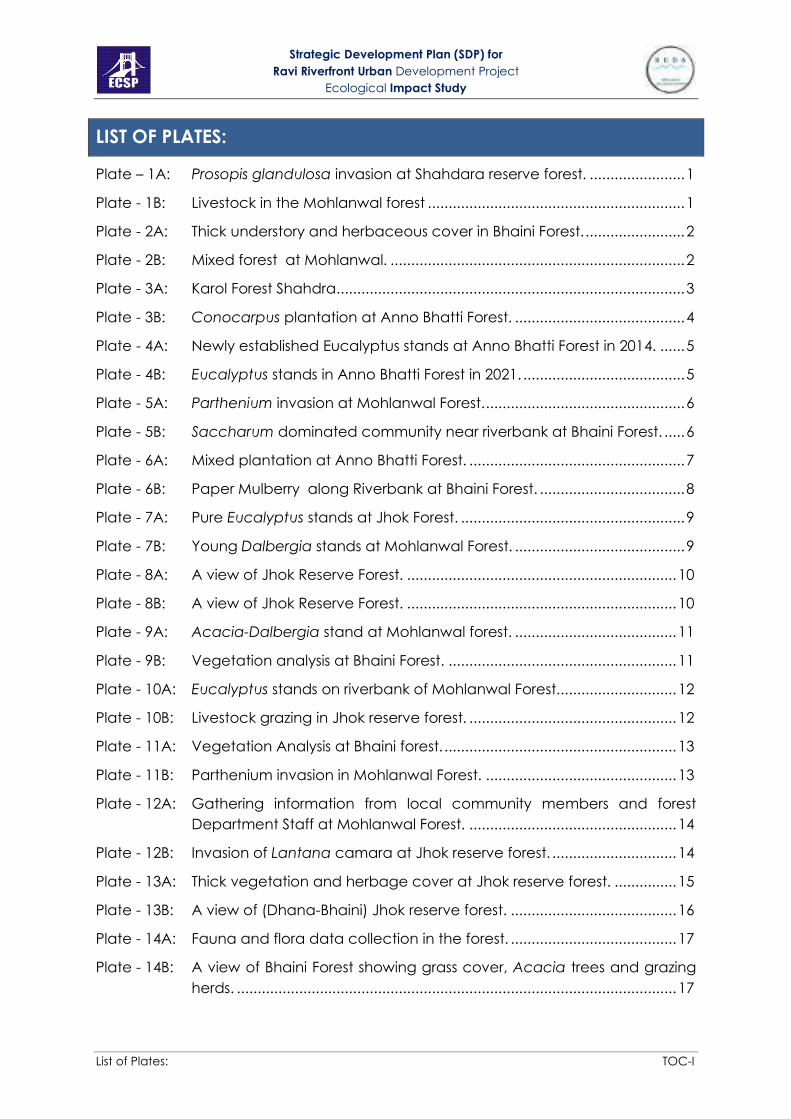
List of Plates: TOC-I
LIST OF PLATES:
Plate – 1A: Prosopis glandulosa invasion at Shahdara reserve forest. ....................... 1
Plate - 1B: Livestock in the Mohlanwal forest .............................................................. 1
Plate - 2A: Thick understory and herbaceous cover in Bhaini Forest. ........................ 2
Plate - 2B: Mixed forest at Mohlanwal. ....................................................................... 2
Plate - 3A: Karol Forest Shahdra .................................................................................... 3
Plate - 3B: Conocarpus plantation at Anno Bhatti Forest. ......................................... 4
Plate - 4A: Newly established Eucalyptus stands at Anno Bhatti Forest in 2014. ...... 5
Plate - 4B: Eucalyptus stands in Anno Bhatti Forest in 2021. ....................................... 5
Plate - 5A: Parthenium invasion at Mohlanwal Forest. ................................................ 6
Plate - 5B: Saccharum dominated community near riverbank at Bhaini Forest. ..... 6
Plate - 6A: Mixed plantation at Anno Bhatti Forest. .................................................... 7
Plate - 6B: Paper Mulberry along Riverbank at Bhaini Forest. ................................... 8
Plate - 7A: Pure Eucalyptus stands at Jhok Forest. ...................................................... 9
Plate - 7B: Young Dalbergia stands at Mohlanwal Forest. ......................................... 9
Plate - 8A: A view of Jhok Reserve Forest. ................................................................. 10
Plate - 8B: A view of Jhok Reserve Forest. ................................................................. 10
Plate - 9A: Acacia-Dalbergia stand at Mohlanwal forest. ....................................... 11
Plate - 9B: Vegetation analysis at Bhaini Forest. ....................................................... 11
Plate - 10A: Eucalyptus stands on riverbank of Mohlanwal Forest. ............................ 12
Plate - 10B: Livestock grazing in Jhok reserve forest. .................................................. 12
Plate - 11A: Vegetation Analysis at Bhaini forest. ........................................................ 13
Plate - 11B: Parthenium invasion in Mohlanwal Forest. .............................................. 13
Plate - 12A: Gathering information from local community members and forest
Department Staff at Mohlanwal Forest. .................................................. 14
Plate - 12B: Invasion of Lantana camara at Jhok reserve forest. .............................. 14
Plate - 13A: Thick vegetation and herbage cover at Jhok reserve forest. ............... 15
Plate - 13B: A view of (Dhana-Bhaini) Jhok reserve forest. ........................................ 16
Plate - 14A: Fauna and flora data collection in the forest. ........................................ 17
Plate - 14B: A view of Bhaini Forest showing grass cover, Acacia trees and grazing
herds. .......................................................................................................... 17

Strategic Development Plan (SDP) for
Ravi Riverfront Urban Development Project
Ecological Impact Study
List of Plates: TOC-II
Plate - 15A: Degraded forest patches in Jhok (Dhana- Bhaini Forest) ...................... 18
Plate - 15B: Guava plantation in agroforestry areas of Dhana-Bhaini Forest. .......... 19
Plate - 16A: Pure willow stand at Bhaini forest ............................................................. 20
Plate - 16B: New areas coming under agroferstry at Dhana-Bhaini forest. .............. 20
Plate - 17A: Eucalyptus stand at Bhaini forest ............................................................. 21
Plate - 17B: Agroferstry at Bhaini forest. ....................................................................... 22
Plate - 18A: Lantana camara invasion at Dhana-Bhaini forest.................................. 23
Plate - 18B: Agroferstry at Bhaini forest in 2014. .......................................................... 23
Plate - 19A: Agroforestry at Bhaini. ............................................................................... 24
Plate - 19B: A distant view of Shadanwali 2 Forest. .................................................... 25
Plate - 20A: Shadanwali 3 Forest................................................................................... 26
Plate - 20B: Shadanwali 3 Forest................................................................................... 26
Plate - 21A: Map of Korotana forest. ............................................................................ 27
Plate - 21B: Nursery at Korotana forest. ....................................................................... 27
Plate - 22A: Agriculture at Korotana forest. ................................................................. 28
Plate - 22B: View of Korotana forest. ........................................................................... 29
Plate - 23A: A grassland near Bhaini forest. ................................................................. 30
Plate - 23B: Pond in the grassland near Bhaini forest. ................................................ 30
Plate - 24A: Grazing in the grassland. .......................................................................... 31
Plate - 24B: Vegetation and fauna analysis in a degraded grassland. .................... 31
Plate - 25A: Overgrazing has resulted in degradation of grassland vegetation. ..... 32
Plate - 25B: Egrets in the fields. ..................................................................................... 32
Plate - 26A: Paddy fields. ............................................................................................... 33
Plate - 26B: Paddy and Sorghum fields. ....................................................................... 33
Plate - 27A: A Lychee orchard. ..................................................................................... 34
Plate - 28B: Corn fields, Gauva orchard and forest at Bhaini. ................................... 34
Plate - 29A: A seasonal Pond. ....................................................................................... 35
Plate - 29B: A freshwater pond in the grassland. ........................................................ 35
Plate - 30A: A freshwater pond in the grassland. ........................................................ 36
Plate - 30B: A wastewater pond close to the village at Kalakhatai road. ............... 36
Plate - 31A: A freshwater pond in the grassland. ........................................................ 37

Strategic Development Plan (SDP) for
Ravi Riverfront Urban Development Project
Ecological Impact Study
List of Plates: TOC-III
Plate - 31B: A freshwater pond in the forest. ............................................................... 37
Plate - 32A: Birds clustered on a small island in the river. ............................................ 38
Plate - 32B: Eroded and cut riverbanks. ...................................................................... 38
Plate - 33A: People crossing the river on boats. .......................................................... 39
Plate - 33B: Shoreline vegetation. ................................................................................ 39
Plate - 34A: People crossing the river on boats. .......................................................... 40
Plate - 34B: Riverbank.................................................................................................... 40
Plate - 35A: View of Ravi River, in the background is Bhaini forest. ........................... 41
Plate - 35B: View of Ravi River, in the background is Mohlanwal forest. .................. 41
Plate - 36A: Riverbank.................................................................................................... 42
Plate - 36B: Walk along the riverbank for data collection. ........................................ 42
Plate - 37A: Fishing in river Ravi. .................................................................................... 43
Plate - 37B: Fishing in river Ravi. .................................................................................... 43
Plate - 38A: View of Ravi river. ...................................................................................... 44
Plate - 38B: View of Ravi river. ...................................................................................... 44
Plate - 39A: Ravi Bridge Shahdara. ............................................................................... 45
Plate - 39B: People using polluted water for bathing and washing at Ravi Bridge
Shahdara. ................................................................................................... 45
Plate - 40A: Polluted riverbank at Ravi Bridge Shahdara. .......................................... 46
Plate - 40B: Polluted riverbank at Ravi Bridge Shahdara. .......................................... 46
Plate - 41A: Livestock grazing on an Island in the river Ravi. ...................................... 47
Plate - 41B: Livestock grazing on an Island in the river Ravi. ...................................... 47
Plate - 42A: Livestock grazing on an Island in the river Ravi. ...................................... 48
Plate - 42B: Livestock grazing on an Island in the river Ravi. ...................................... 48
Plate - 43A: Shoreline vegetation on the island. ......................................................... 49
Plate - 43B: Distant view of Kamran Baradari Island. .................................................. 49
Plate - 44A: Kamran Baradari........................................................................................ 50
Plate - 44B: Kamran Baradari........................................................................................ 50
Plate - 45A: A wasteland in the study area. ................................................................ 51
Plate - 45B: A wasteland in the study area. ................................................................ 51
Plate - 46A: Insect collection using sweep nets. ......................................................... 52
Plate - 46B: Insect collection using sweep nets. ......................................................... 52
Strategic Development Plan (SDP) for
Ravi Riverfront Urban Development Project
Ecological Impact Study
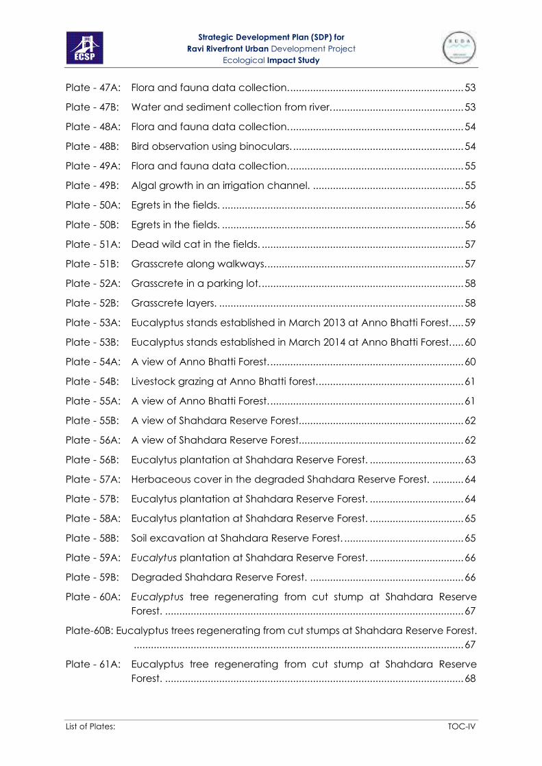
List of Plates: TOC-IV
Plate - 47A: Flora and fauna data collection. ............................................................. 53
Plate - 47B: Water and sediment collection from river. .............................................. 53
Plate - 48A: Flora and fauna data collection. ............................................................. 54
Plate - 48B: Bird observation using binoculars. ............................................................ 54
Plate - 49A: Flora and fauna data collection. ............................................................. 55
Plate - 49B: Algal growth in an irrigation channel. ..................................................... 55
Plate - 50A: Egrets in the fields. ..................................................................................... 56
Plate - 50B: Egrets in the fields. ..................................................................................... 56
Plate - 51A: Dead wild cat in the fields. ....................................................................... 57
Plate - 51B: Grasscrete along walkways. ..................................................................... 57
Plate - 52A: Grasscrete in a parking lot. ....................................................................... 58
Plate - 52B: Grasscrete layers. ...................................................................................... 58
Plate - 53A: Eucalyptus stands established in March 2013 at Anno Bhatti Forest. .... 59
Plate - 53B: Eucalyptus stands established in March 2014 at Anno Bhatti Forest. .... 60
Plate - 54A: A view of Anno Bhatti Forest. .................................................................... 60
Plate - 54B: Livestock grazing at Anno Bhatti forest. ................................................... 61
Plate - 55A: A view of Anno Bhatti Forest. .................................................................... 61
Plate - 55B: A view of Shahdara Reserve Forest.......................................................... 62
Plate - 56A: A view of Shahdara Reserve Forest.......................................................... 62
Plate - 56B: Eucalytus plantation at Shahdara Reserve Forest. ................................. 63
Plate - 57A: Herbaceous cover in the degraded Shahdara Reserve Forest. ........... 64
Plate - 57B: Eucalytus plantation at Shahdara Reserve Forest. ................................. 64
Plate - 58A: Eucalytus plantation at Shahdara Reserve Forest. ................................. 65
Plate - 58B: Soil excavation at Shahdara Reserve Forest. .......................................... 65
Plate - 59A: Eucalytus plantation at Shahdara Reserve Forest. ................................. 66
Plate - 59B: Degraded Shahdara Reserve Forest. ...................................................... 66
Plate - 60A: Eucalyptus tree regenerating from cut stump at Shahdara Reserve
Forest. ......................................................................................................... 67
Plate-60B: Eucalyptus trees regenerating from cut stumps at Shahdara Reserve Forest.
.................................................................................................................... 67
Plate - 61A: Eucalyptus tree regenerating from cut stump at Shahdara Reserve
Forest. ......................................................................................................... 68

Strategic Development Plan (SDP) for
Ravi Riverfront Urban Development Project
Ecological Impact Study
List of Plates: TOC-V
Plate - 61B: Interviewing local people at Shahdara Reserve Forest. ........................ 68

Strategic Development Plan (SDP) for
Ravi Riverfront Urban Development Project
Ecological Impact Study
0 EXECUTIVE SUMMARY 1
EXECUTIVE SUMMARY
Ravi Riverfront Urban Development Project is a proposed project to be carried-out on
both sides of a 46 km long stretch of River Ravi. The project will have three phases
which foster mega urban development in the area. This ecological impact assessment
was carried-out as part of Environmental Impact Assessment (EIA) to gather
ecological data of the Ravi Riverfront Urban Development Project. The proposed
project may have impacts on the natural environment including existing fauna, flora
and their wild habitats. This assessment includes the study of both aquatic and
terrestrial ecology of the project area. The guiding principle for this part of the EIA
report is to conserve major habitats of flora and fauna in the area. This section of the
report includes identification, prediction and evaluation of existing habitats, flora and
fauna. The baseline ecological study was of 40 days in which tours of the area were
arranged in 2014 to assess plants and animals present in different habitats. Survey was
repeated in January 2021 for verification and updating the previously gathered
information. After a vigorous literature review, certain criteria were established to
evaluate habitats, animal and plant species. Keeping in view international and
national legislations, protection status of species found in all habitats were sorted. This
helped in proposing options for the conservation of respective habitats of protected
species. The project site is significant due to its biodiversity richness which was 116
species of fauna and 147 species of flora. Fauna included 24 species of insects (only
butterflies, dragonflies, damselflies, and mosquitoes), 53 of birds, 13 of mammals, 9 of
reptiles, 3 of amphibians and 14 of fish. There were 147 species of plants in the area.
Nine bird, 2 mammal and 5 reptile species are protected year-round under Schedule
three of the Punjab Wildlife Act (Amendment) 2007. All the five nationally protected
reptile species are on either Appendix I, II or III of CITES. Indian cobra and Ceylon
chameleon are on Appendix II of CITES. The native fish species Mully (Wallago attu)
and the Indian soft-shell turtle are classified as ‘Vulnerable’ under the IUCN Red Data
List of threatened species. In mammals Jungle Cat and Indian Mongoose are
protected under Schedule III of Punjab Wildlife Act (Amendment 2007) while Asiatic
Jackal and Indian Mongoose are on Appendix III of CITES. Indian bull frog is protected
under Apendix II of CITES. None of the plant and insect species are either nationally or
internationally protected. The detailed surveys assisted in mapping momentous
ecological relationships of the area i.e. food chains and food webs between aquatic
Strategic Development Plan (SDP) for
Ravi Riverfront Urban Development Project
Ecological Impact Study
0 EXECUTIVE SUMMARY 2
and terrestrial flora and fauna. The potential ecological impacts from the project’s
construction and operation were identified and their possible mitigation measures are
proposed for enactment of habitat and species there. It is strongly recommended
from this ecological impact assessment report that river is a substantial body as a part
of an aquatic biome which should be conserved. Other habitats, most importantly
shoreline and forests are essential habitats for survival of many animal and plant
species, if they will be destroyed or affected by the development in the area,
consequently many flora and fauna species will also disappear.

Strategic Development Plan (SDP) for
Ravi Riverfront Urban Development Project
Ecological Impact Study
Section - 1: INTRODUCTION 1
SECTION - 1: INTRODUCTION
This ecological impact assessment is carried-out as part of an Environmental
Impact Assessment (EIA) to gather ecological data of the Ravi Riverfront
Urban Development Project which may have an impact on the natural
environment including existing fauna, flora and wildlife habitats. This
assessment includes both aquatic and terrestrial ecology of the study area.
The guiding principle for this part of the EIA report is to conserve major
habitats of flora and fauna in the area.
This chapter includes identification, prediction and evaluation of existing
habitats of study area, flora and fauna. The baseline ecological study was of
40 days in which tours of the study area were arranged to assess plant and
animals in different times of the day. The potential ecological impacts from
the project’s operation and construction were identified and possible
mitigation measures are proposed for enactment of habitat and species
there.
1.1 OBJECTIVES OF THE ECOLOGICAL IMPACT ASSESSMENT STUDY
The objectives of this ecological study were to
• identify important ecological resources within the study area
• assess the potential impacts on these ecological resources from the
development in the area
• provide practical mitigation measures to combat, minimize or avoid impacts
from the development within the area
1.2 METHODOLOGY TO CONDUCT ECOLOGICAL IMPACT ASSESSMENT
The current study was carried-out in following steps:
1. Documentation of important ecological resources, i.e surveys were
conducted to gather data about habitat, flora and fauna in the
region, in addition to it, available literature (published reports, research
papers etc.) were searched and used in compiling ground
observations.
2. Evaluation of significance of ecological resources
3. Prediction of ecological impacts on the resources due to project
development
4. Provision of mitigation measures which will reduce or minimize impacts
identified on ecological resources.
1.3 LEGISLATION AND GUIDELINES
This Ecological impact assessment was carried-out in consideration of
national and international legislations which Pakistan is abided by. The list of

Strategic Development Plan (SDP) for
Ravi Riverfront Urban Development Project
Ecological Impact Study
Section - 1: INTRODUCTION 2
guidelines and conventions are as follows:
International legislations: Pakistan is signatory to many international
conventions and treaties
• Ramsar Convention: this is intergovernmental Convention on Wetlands of
International Importance; Pakistan is ratified to this convention on November
23, 1976. The main objective is to conserve world’s wetlands and their
resources.
• Bonn Convention: Convention on the Conservation of migratory Species of Wild
Animals, June 1979 and came into force in Pakistan in 1987. The main aim of
this convention is to conserve terrestrial, aquatic and avian migratory species
throughout their range.
• Convention on Biological Diversity CBD: Pakistan ratified to CBD in 1994; it
recognizes the intrinsic Value of biological diversity and ecological, genetic,
social, economic, cultural, educational, recreational, and aesthetic values of
biodiversity and its components.
• IUCN Red List of threatened species: The International Union for Conservation
of Nature and Natural resources (IUCN) Red List of Threatened Species provides
taxonomic, conservation status and distribution information on plants, fungi
and animals that have been globally evaluated using the IUCN Red List
Categories and Criteria. This system is designed to determine the relative risk of
extinction, and the main purpose of the IUCN Red List is to catalogue and
highlight those plants and animals that are facing a higher risk of global
extinction (i.e. those listed as Critically Endangered, Endangered and
Vulnerable). It also includes information on plants, fungi and animals that are
categorized as Extinct or Extinct in the Wild; on taxa that cannot be evaluated
because of insufficient information (i.e., are Data Deficient); and on plants,
fungi and animals that are either close to meeting the threatened thresholds
or that would be threatened were it not for an ongoing taxon-specific
conservation programme (i.e., are Near Threatened).
• CITES: The Convention on International Trade in Endangered Species of Wild
Fauna and Flora is an international agreement between governments. Its aim
is to ensure that international trade in specimens of wild animals and plants
does not threaten their survival. The species covered by CITES in the project
area are listed in Appendix-1.
National Legislation: Acts and Rules
Following national laws and acts are in force in Pakistan for the protection of
Environment and biological diversity.
• Pakistan Forest Act 1927; Forest (Amended) act 2001

Strategic Development Plan (SDP) for
Ravi Riverfront Urban Development Project
Ecological Impact Study
Section - 1: INTRODUCTION 3
• The Punjab Wildlife (Protection, Preservation, Conservation and Management)
(Amendment) Act, 2007. The detail of mammals, reptiles, amphibians and birds
protected throughout the year (Third Schedule) is attached in Appendix-2.
• Pakistan Environmental Protection Act, 1997
• Pakistan National Conservation Strategy (1992)
• Biodiversity Action Plan (2000)
• National Environmental Policy (2005)
• National Forest Policy (2010)
• National Climate Change Policy (2012)
1.4 STUDY TEAM
The details of ecological study team members is given below:
Table 1-1: Ecology Study Team
Sr.
No.
Name of the
Member Specialization Qualification
1 Dr. Faiza Sharif
Conservation
Biologist/Restoration
Ecologist
Ph. D. Botany (GCU Lahore)
2 M. Umar Hayyat EIA specialist
M. Phil. Environmental
Science
(GCU Lahore)
PhD Scholar Environmental
Science (GCU Lahore)
3 Dr. Rashid
Mahmood Botanist
M. Phil. Botany (GCU Lahore),
PhD Environmental Science
(GCU Lahore)
4 Dr. Laila Shahzad Environmentalist
M. Phil. Environmental
Science (GCU Lahore), PhD
Environmental Science
(LCWU Lahore)
5 Dr. Sumbal Nazir Zoologist
M. Phil. Zoology (GCU
Lahore), PhD Environmental
Science (GCU Lahore)
6 Ms. Asma Mansoor Restoration Ecologist
BSc (Hons.) Environmental
Science (GCU Lahore), MPhil.
Environmental Science (GCU
Lahore)
7 Ms. Arooj Fatima Habitat Ecologist BSc (Hons.) Environmental
Science (GCU Lahore), MPhil.

Strategic Development Plan (SDP) for
Ravi Riverfront Urban Development Project
Ecological Impact Study
Section - 1: INTRODUCTION 4
Sr.
No.
Name of the
Member Specialization Qualification
Environmental Science (GCU
Lahore)
8 Mr. Zawar Haider Field Surveyor/
Environmentalist
BSc (Hons.) Environmental
Science (GCU Lahore), MPhil.
Environmental Science (GCU
Lahore)
9 Mr. Junaid Nadeem Wildlife Expert M. Phil. Zoology
GC University, Lahore.
10 Mr. Shahzad Siddiq Environmentalist
M. Phil. Environmental
Science
(GCU Lahore),
PhD Scholar Environmental
Science (GCU Lahore)

Strategic Development Plan (SDP) for
Ravi Riverfront Urban Development Project
Ecological Impact Study
Section - 2: OBSERVATIONS AND INTERPRETATIONS 1
SECTION - 2: OBSERVATIONS AND INTERPRETATIONS
2.1 SECTION-1 ECOLOGICAL BASELINE STUDY OF THE PROJECT
2.1.1 Project Study Area
The area of the project is 46 km downstream on the River Ravi. The project will
have three phases, will be called phase-1, phase-2 and phase 3. This riverfront
urban development will take place on 46 km Long River with a stretch of 5 km
on each side of the riverbank. The cited area is diverse mix of forests,
agriculture, ponds, lowlands and wasteland etc.
River Ravi: Total area of the River present in the project boundary is about
9,908 Acre. The banks of the River Ravi are vegetated with tree species like
Dalbergia sissoo, Eucalyptus and Acacia nilotica etc. where ever riparian
forests exist. Many grasses and sedges are common on the riverbank as
Cynodon dactylon, Saccharum munja, S. spontaneum, Cyperus difformis
and C. iria. Important fishes of river Ravi are Thaila, Mori, Rohu, Singharee and
Carp etc. The river Ravi is highly polluted river of Punjab with untreated
industrial and municipal waste ending up in it especially in the areas around
Lahore city. The situation is further worsened by dumping of municipal solid
waste on its banks. There are many settlements of katchi abadis close to the
river, which add up in polluting riverbank as well as dry bed of the river. Figure
2-1 shows the locations of the ecological study sites within the Project area.
Figure 2-1: Map of the Project area showing the locations of ecological study sites

Strategic Development Plan (SDP) for
Ravi Riverfront Urban Development Project
Ecological Impact Study
Section - 2: OBSERVATIONS AND INTERPRETATIONS 2
2.1.2 Steps in Ecological baseline study
The ecological baseline study was carried-out in three steps:
A. identifying habitats in the area,
B. identifying species of fauna and their protection status
C. identifying species of flora and their protection status
A) Habitat survey and profile
The total project area was surveyed in a team and data was gathered for
the habitat information on the basis of following: Identifying types of habitats,
observing existing condition in each habitat and its ecological characteristics
and providing overview of other distinct characters of the site. The study area
is curbed to 46 km on the both sides of riverbank. The track was determined
by using aerial photographs and the GIS-based maps helped in locating side
roads from the main course. There are five main roads entering from different
sides of the project area that gave access to the study sites i.e. Kala Khatai
road, G.T. road, Lahore ring road, Multan road and Jaranwala road. Habitats
were studied starting from main roads and moving through side roads to
ending up at river at most of the locations. The project area has diverse kinds
of habitats ranging from forested area, agriculture fields, lowland grasslands,
orchards, wastelands etc. Table 2-1 shows types of landuses in project site
and their GIS based estimated areas before the development.
Table 2-1: GIS based estimated existing landuses with their areas within the project
site.
Landuse Area (Acre)
Agriculture 77,357
Barren Land 2,851
Bund or Spurs 295
Creeks 526
Drainage 259
Dumping Site 736
Flood Plain 4,482
Forest 4,958
Graveyard 148.87
Industrail & Commercial Zone 461.9
Island 33.65
Orchards 2,600
Planned 923
Ponds 984
River 3,591
Settelments 1,868
Total 102,074

Strategic Development Plan (SDP) for
Ravi Riverfront Urban Development Project
Ecological Impact Study
Section - 2: OBSERVATIONS AND INTERPRETATIONS 3
In the project area, each type of habitat, species of flora and fauna were
observed and evaluated on the basis of criteria which were developed to
assess ecological characteristics and their importance.
Criteria for Evaluating Ecological significance and Ecological impacts of
habitats, flora and fauna
The ecological impact is direct or indirect effect on species or their habitat
due to changes in the environment by a project. In general, an ecological
significance refers to the importance of a specie/site to particular area
whereas ecological impact evaluates importance of certain species or a
habitat specific to the project area in comparison to other less important
ones. Criteria that were used to evaluate ecological importance and
impacts of development on the local ecosystems are presented as follows
(Table 2-2).
Table 2-2: Criteria used for evaluating a site/habitat.
Criteria Remarks
Naturalness
A natural habitat with lesser modifications by human beings
is highly valued in ecological valuation. The more natural
an area will be, the higher will be its importance in
ecological evaluation.
Size A habitat with large area shall be of more importance than
a small area.
Diversity
In a habitat, more diversity of the species communities,
higher will be their conservation value in ecological
valuation.
Rarity
Rarity is a trait of habitats as well as species. The rarer
habitats and species will have higher value of the site than
those without rarity.
Re-creatability Habitats those are difficult to be re-created naturally or
artificially are usually valued higher. e.g. a natural forest
Fragmentation
Fragmentation occurs when a continuous larger habitat
loss into smaller parts/remnants. The more fragmented
habitats have the lower value and vice versa.
Ecological linkage
Ecological linkage refers to a close proximity of two
habitats. e.g. a wetland in a forest area. The value of a
habitat increases if it lies in close proximity and/or links
functionally to a highly valued habitat of any type.
Potential value
Certain sites, through appropriate management or natural
processes, may eventually develop a nature conservation
interest substantially greater than that existing at present.
Factors limiting such potential being achieved shall be
noted.

Strategic Development Plan (SDP) for
Ravi Riverfront Urban Development Project
Ecological Impact Study
Section - 2: OBSERVATIONS AND INTERPRETATIONS 4
Criteria Remarks
Nursery/breeding
ground
These are areas of high importance due to the potential of
regeneration and long-term survival of many organisms and
their populations. e.g. coral reefs
Age
Old Long-standing natural or semi-natural habitats are of
higher value. For some habitats such as woodlands, older
ones are normally valued much higher than recent ones.
Abundance/Richness
of wildlife
In general sites supporting more wildlife will be rated higher
than having less/no wildlife.
In the project area, flora and fauna species were identified and their status
was evaluated on the basis of following criteria as shown in Table 2-3
Table 2-3: Criteria for evaluating species found within a habitat
Criteria Remarks
Protection status
It refers to the Species listed under local legislation and
international conventions for protection and conservation
purposes. Species of wildlife shall be given special attention.
Rarity
Rarity is a trait of high concern in ecological evaluation. The
rarer the species, the more value it has. Although exotic species
either rare have low value.
Distribution
Distribution of species can be extensive or restricted. Species
with restricted distribution (locally or regionally) will be of higher
value because of its vulnerable status than those more
widespread ones. In this context endemic species are of higher
concern to a nation.
After documenting the baseline data and impacts of construction in the said
area, ecological impact is identified as described in Table 2-4.
Table 2-4: Evaluating the significance of an ecological impact.
Criteria Remarks
Habitat quality
The quality of habitat is defined to be the basic characteristics
of an ecological site; as how diverse the habitat is. “The impact
will be more significant if ecologically important habitats are
affected”. The criteria used for evaluating the ecological
importance of a habitat can be naturalness of the area, size,
diversity, rarity etc. as shown in Table 2.
Species
Species refer to the organism of a population occupying an
area. “The impact will be more significant if ecologically
important species are affected”. The criteria used for evaluating
the ecological importance of a species are shown in Table 3.
Size/Abundance The impact will be greater if larger areas of a habitat or greater
numbers of organisms are affected (e.g. The impact of
Strategic Development Plan (SDP) for
Ravi Riverfront Urban Development Project
Ecological Impact Study
Section - 2: OBSERVATIONS AND INTERPRETATIONS 5
Criteria Remarks
indiscriminate clearance of woodland is more severe than that
of selective felling of trees at the same site).
Reversibility Permanent and irreversible impacts are usually more significant
than temporary and reversible ones.
Duration Long term impacts are usually more significant than short term
ones.
Magnitude
Usually the greater the magnitude of the environmental
changes (e.g. increase in pollution loads, decrease in food
supply), the more significant is the impact.
Habitat Information
1: Forests: There are seven forests in the project area with a total area of 5766
Acre out of that 789 is under Riverbed, 1235 is with Pak Army, 3697.5 is with
forest Department and 44.5 is encroached upon. Out of the 3697.5 Acre area
that is with the Forest Department only 1822 Acre is planted (Table 2-5,
Appendices 6-8). There is 1235 Acre area of Shadanwali, Korotana and Jhok
forests that is with the Pak Army that had both forest stands and agroforestry.
The exact estimation of the planted cover of these forests under possession
of both organizations was difficult, so GIS based estimation was used for this
purpose (
Figure 2-2). The results showed that total planted forest cover is upto 4958
Acre, but the field visits showed that in many areas tree density was very low
such as agroforestry areas of Dhana-Bhaini and Korotana Forests. The tree
species planted in these forests comprise mainly of Eucalyptus, Sheesham,
Kikar, Willow, Simbal and Mulberry etc.
Table 2-5: Details of the forest areas within the project boundary.

Strategic Development Plan (SDP) for
Ravi Riverfront Urban Development Project
Ecological Impact Study
Section - 2: OBSERVATIONS AND INTERPRETATIONS 6
Legal
Status Name
Forest
type
Area under Forest Department
(Acre)
Un
de
r Pa
k A
rmy
(A
cre
)
Un
de
r R
ive
rbe
d
(Ac
re)
En
cro
ac
he
d (
Ac
re)
Est
ima
ted
are
a u
nd
er
Riv
er
aft
er
de
ve
lop
me
nt
(Ac
re)
Gro
ss A
rea
Pla
nte
d
Tota
l b
lan
k
Pla
nta
ble
bla
nk
un
-pla
nta
ble
bla
nk
Section
38 Anno Bhatti Riverian 272 260 12 0 0 - - 12 117.43
Reserved Shahdara Riverian 1615 860 755 20 732 - 732 2.5 21.33
Un-
classed
Kamran
Bara Dari Riverian 21 15 6 0 6 - 6 - 0
Reserved Jhok* Riverian 3071 672 916 927 42 590 - 3 0
Reserved Shadanwali* Riverian 380 - - - - 326 - 24 3.31
Reserved Korotana* Riverian 359 - - - - 319 40 0 85.17
Un-
classed Katar Bund Riverian 48 15 19 19 0 - 11 3 27.39
Total 5766 1822 1708 966 780 1235 789 44.5 254.63
(Source: Punjab Forest Department as of January 2021), *1235 Acre area of these forests is undercontrol of Pak Army
and the planted area reported here is only that is under Forest Department.

Strategic Development Plan (SDP) for
Ravi Riverfront Urban Development Project
Ecological Impact Study
Section - 2: OBSERVATIONS AND INTERPRETATIONS 7
Figure 2-2: GIS based estimation of the forest areas in the project
1) Anno Bhatii Forest: The total area of this forest is 272 Acre and was
approached by the team through Lahore Ring Road (Appendix 6). The
planted area of this forest is 260 Acre according to the report of Punjab Forest
Department as of July 2020 (Table 6). In 2014 visit it was found that 60 Acre
area of the forest was planted with Eucalyptus in March 2013 and March 2014
(30 Acre each year). Other than Eucalyptus few trees of Acacia nilotica, A.
modesta, and Dalbergia sissoo were found there and the forest was in much
degraded state. But in the current survey in January 2021 it was found that its
150 Acre area was planted in 2016-17, and 25-Acre area in 2017-18 with
Eucalyptus, Kikar, Sheesham, Melia azedarach (Bakain), Kachnar, Morus alba
(Toot), Neem and Conocarpus spp. Among the invasive species Prosopis
juliflora, Paper mulberry and Parthenium hysterophorous were present there.
Herbaceous flora mostly comprised of Croton sparsiflorus, Calotropis procera
and Cynodon dactylon.
2) Shahdara Reserve Forest: The total area of this forest is 1615 Acre and was
approached by the team through Lahore Ring Road (Appendix 7). This is
second largest forest by area in the study site. This forest had a very low
planted area and was in a much-degraded state in 2014, as its soil has also
been excavated and removed from many places. Total planted area of this
forest was only 1.84 Acre in 2014. Almost all of the Eucalyptus trees seem to
be regenerating from cut stumps. Other than Eucalyptus, Ziziphus
nummularia, C. procera, Cynodon dactylon Desmostachya bipinnata,
Sonchus asper and Cyprus were common wild species. Site was heavily
invaded by Prosopis glandulosa. Some compartments of this forest are in the
river but still it had a very large area that was in need of rehabilitation in 2014.
January 2021 visit revealed that the total planted area of this forest is now 860
Acre out of that 600 Acre in Karol were planted in 2014-15 with Eucalyptus
camaldulensis, Morus alba, Morus nigra, Shireen, Simbal, Popular, Jaman,
Conocarpus and Jacaranda etc. and 120 Acre was planted in 2015-16 with
Eucalyptus spp. Invasive species here included P. hysterophorus and Prosopis
juliflora.
3) Jhok Forest: This is the largest forest in the study area and spreads on both
sides of the river. The part of it on the right side of the river while travelling
downstream is known as Dhana Bhaini forest and on the left bank is known as
Strategic Development Plan (SDP) for
Ravi Riverfront Urban Development Project
Ecological Impact Study
Section - 2: OBSERVATIONS AND INTERPRETATIONS 8
Chung Mohlanwal forest named after the adjacent towns (Appendix 8). The
total area of this forest is 3071 Acre out of that 672 Acre is planted as per
Forest Department. Its 590 Acre is under Pak Army control in Dhana-Bhaini side
of the forest that also had forest cover that is not included in the above
estimate. Some area of this forest is also under the river but still it has 927 Acre
area that can be rehabilitated.
Dhana Bhaini forest was approached by the team through Lahore-
Jaranwala road. Some part of it is under army control and is under
agroforestry where seasonal vegetables, corn and sorghum crops were
observed. This forest is under threat because of agroforestry as agricultural
activities like pesticide sprays, frequent irrigation and fertilizer use can have
detrimental effects on soil properties as well as on local fauna and flora.
January 2021 visit revealed more area to be under agriculture and young
guava plantations were also observed. Chung Mohlanwal Forest was
approached by the team through Multan road. This forest is larger in size as
compared to Dhana Bhaini. This forest was stressed by grazing of large
number of livestock kept by the local community. Forest is planted with
Eucalyptus camaldulensis, D. sissoo, Acacia nilotica and Salix tetrasperma
etc. Both these forests were in more intact state as compared to the others
with plantations that were old plus tree stands that were less than 10 years
old. The forest was rich in biodiversity. Invasion of Paper mulberry (especially
in Dhana Bhaini), Lantana camara, P. hysterophorus and mesquite was found
here.
4) Shadanwali Forest: This forest is scattered in small patches known as
Shadanwali 1, 2, 3 and 4 (Appendix 8). The forest was approached by the
team through Lahore-Jaranwala road. Most area of this forest in
compartments 2, 3 and 4 is under Army control while compartment 1 (24
Acre) is under encroachment. As per Forest Department information no
forest cover is shown here because 326 Acre is with Army, but site visit and
data collected from the site showed that almost 340 Acre area of this forest
(Shadanwali 2, 3 and 4) is planted. Most common trees there are Sheesham,
Eucalyptus, Simbal, Toot and Bakain.
5) Korotana Reserve Forest: The total area of this forest is 359 Acre and was
approached by the team through Lahore-Jaranwala road (Appendix 8).
Most of this forest is under Army control (319 Acre) is with the Army and 40
Acre is in Riverbed . This forest is predominantly planted with Eucalyptus and
Sheesham.
6) Katar Bund Forest: This forest is divided into Katar Bund North and South and
is approachable from Multan Road. This is a very small patch of 48 Acre out
of that 19 Acre is Katar Bund North and 29 Acre is Katar Bund South (Appendix
8). Only 15 Acre area of Katar Bund is planted with Eucalyptus, 11 Acre is
under River and 3 Acre is encroached upon.

Strategic Development Plan (SDP) for
Ravi Riverfront Urban Development Project
Ecological Impact Study
Section - 2: OBSERVATIONS AND INTERPRETATIONS 9
7) Targhar (Kamran Bara Dari): This is an ‘un-classed’ forest with an area of 21
Acres. The forest is mainly planted with Eucalyptus, Sheesham, Arjun and
Willow etc. The whole of the area of this forest will be protected in the new
development by creating an island.
GIS based estimate has shown that in the new development almost 117 Acre area of
Anno Bhatti, 85 of Korotana, 27 of Katar Band North, 21 of Shahdra and 3.31 of
Shadanwali 4 forests will be lost because of river channelization and widening, while
Jhok, Kamran Bara Dari forests will remain unaffected
Figure 2-3: GIS based estimation of the forest areas affected by channel widening
of River Ravi after development.
The forests were surveyed by the team to identify plant species. Quadrats of
10 m × 10 m were marked in the forests and the number of herbs, shrubs and
trees present in it were recorded (Table 2-6 and Plates 4-23). The samples of
unidentified species were collected and were identified in the laboratory
using available literature and electronic databases.

Strategic Development Plan (SDP) for
Ravi Riverfront Urban Development Project
Ecological Impact Study
Section - 2: OBSERVATIONS AND INTERPRETATIONS 10
Table 2-6: Evaluation of forests in the Project area
Criteria Remarks
Naturalness
The forests in the project area are seminatural, as they contain
planted species that are not native to Pakistan like Eucalyptus
spp. along with native species like D. sissoo and A. nilotica etc.
These forests are providing habitat to many native species of
fauna and flora. Agroforestry was introduced in some areas of
the Jhok and Korotana forests. Invasion of Prosopis juliflora,
Prosopis glandulosa, Lantana camara, Broussonetia and
Parthenium has been observed in different forests.
Size There are seven forests in the project area of different sizes
ranging from 48-3071 Acre.
Diversity Diversity of species and habitat types present in the forests is high.
Rarity
Habitat is rare because of a river and forest combination and
largescale conversion of land into agriculture. Few species are
vulnerable according to their conservation status in the region.
Re-creatability
Such forests are not easily re-creatable and it takes long time for
the trees to grow and the diverse species assemblages to
develop from recolonization and establishment.
Fragmentation
The forests are not connected and most of them are fragmented
and isolated. There is a need to develop corridors and create
buffers around them.
Ecological linkage
They had good ecological linkages as they are close to
agriculture fields, river and there are temporary ponds created in
the low-lying areas after rains or floods.
Potential value They have very high conservation value.
Nursery/breeding
ground
Such forests provide important nursery or breeding ground to
many mammals, birds and reptiles.
Age
These forests are old but there are mix of old and comparatively
young trees in the forests as plants are added when so ever
budget is available. Some of the trees are lost after floods or
harvested by the forest department each year.
Abundance/Richness
of wildlife
These forests have high species richness especially of plants, birds
and invertebrates. Diversity of species in the forests is high with 94
plant species and 67 species of birds, reptiles, mammals and
amphibians.
2: Low-lying Grasslands: There are few low-lying grassland areas within the
study area. The lowland areas are inundated by the river when water level is
high after monsoon and during the dry season agriculture is practiced on
some parts of them. One such large grassland is situated adjacent to Dhanna
Bhaini forest. This area was dominated by Cynodon dactylon and other herbs

Strategic Development Plan (SDP) for
Ravi Riverfront Urban Development Project
Ecological Impact Study
Section - 2: OBSERVATIONS AND INTERPRETATIONS 11
and grasses (Plates 24-26A). Common species were Croton sparsiflorus,
Polygonum plebejum and Saccharum spontaneum. Some invasion of
Parthenium hysterophorus was also observed. Many ephemeral pools
appear during rainy season that add up to their wildlife and habitat diversity.
These areas are used by the people for livestock grazing. Besides flora, there
were bird species like acridoeheres tristis, hoplopterus indicos, and easer
domesticus etc. Other animal species included Hystrix indica, and Golunda
elliota.
Table 2-7: Evaluation of low-lying grassland in the Project area
Criteria Remarks
Naturalness The low-lying grasslands in the area are natural. But they suffer
from disturbances like agricultural activity and grazing.
Size
Generally, they are not one of the major habitat types in the
area. They are productive areas because seasonal flooding
adds nutrients and sediments making them suitable for
agriculture.
Diversity Because of their smaller size diversity of species and habitats
was low as compared to the forests.
Rarity Because of its competitive agricultural use this is a rare
habitat type within the study area.
Re-creatability Because of the presence of grasses, it can be comparatively
easily recreated.
Fragmentation These grasslands are subjected to fragmentation from the
forest areas.
Ecological linkage Habitat value is high because of linkages with agricultural
fields, river and ponds.
Potential value
Due to human disturbance in the form of cattle grazing and
agriculture this area is under threat. Economic benefits can
be generated from these areas because of the presence of
species like Saccharum spontaneum and S. munja that can
be exploited on sustainable basis.
Nursery/breeding
ground
They usually have comparatively low value in context of
breeding grounds for other organisms, but they act as a
refuge for wildlife.
Age
Their age is varied from few years to several years as these
are recreated repeatedly due to natural and anthropogenic
disturbances.
Abundance/Richness of
wildlife
Moderate with 10 plant species (excluding pond) and 52
species of birds, reptiles, mammals and amphibians.
Strategic Development Plan (SDP) for
Ravi Riverfront Urban Development Project
Ecological Impact Study
Section - 2: OBSERVATIONS AND INTERPRETATIONS 12
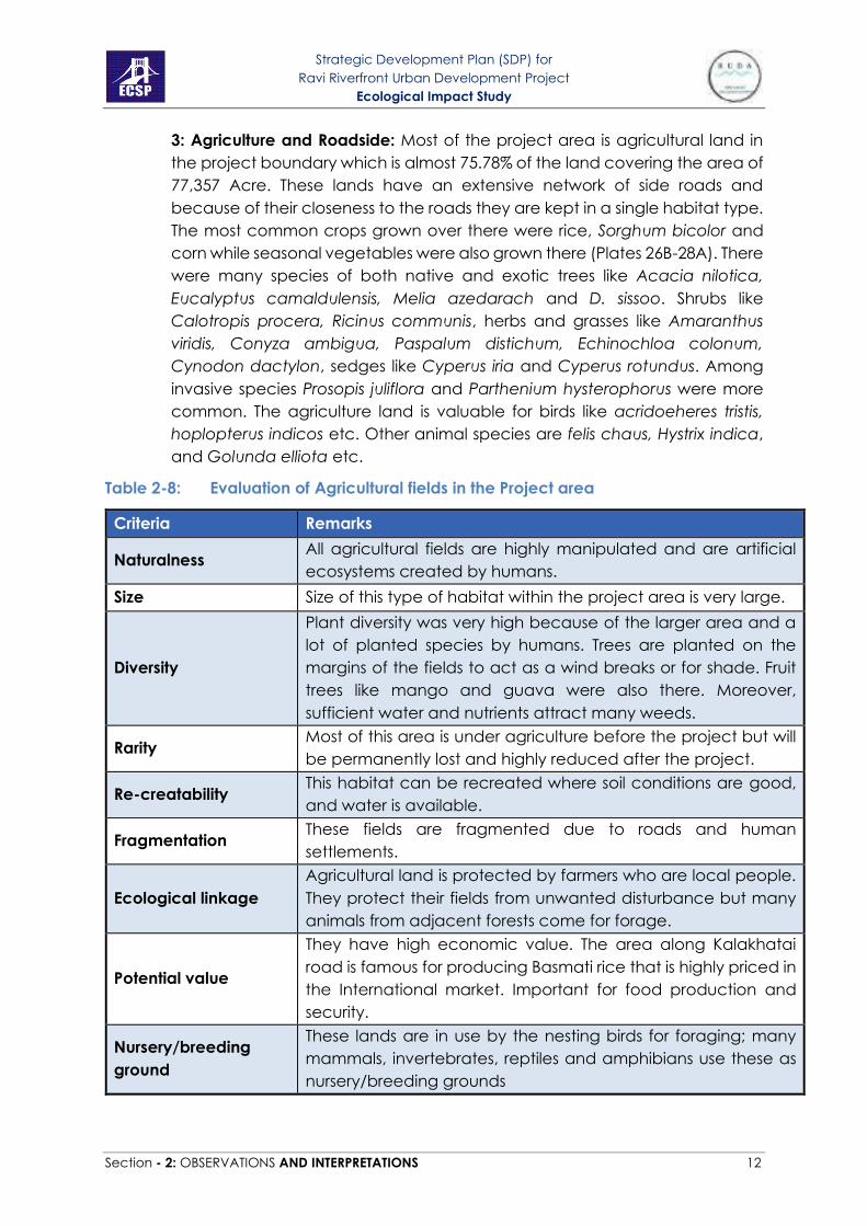
3: Agriculture and Roadside: Most of the project area is agricultural land in
the project boundary which is almost 75.78% of the land covering the area of
77,357 Acre. These lands have an extensive network of side roads and
because of their closeness to the roads they are kept in a single habitat type.
The most common crops grown over there were rice, Sorghum bicolor and
corn while seasonal vegetables were also grown there (Plates 26B-28A). There
were many species of both native and exotic trees like Acacia nilotica,
Eucalyptus camaldulensis, Melia azedarach and D. sissoo. Shrubs like
Calotropis procera, Ricinus communis, herbs and grasses like Amaranthus
viridis, Conyza ambigua, Paspalum distichum, Echinochloa colonum,
Cynodon dactylon, sedges like Cyperus iria and Cyperus rotundus. Among
invasive species Prosopis juliflora and Parthenium hysterophorus were more
common. The agriculture land is valuable for birds like acridoeheres tristis,
hoplopterus indicos etc. Other animal species are felis chaus, Hystrix indica,
and Golunda elliota etc.
Table 2-8: Evaluation of Agricultural fields in the Project area
Criteria Remarks
Naturalness All agricultural fields are highly manipulated and are artificial
ecosystems created by humans.
Size Size of this type of habitat within the project area is very large.
Diversity
Plant diversity was very high because of the larger area and a
lot of planted species by humans. Trees are planted on the
margins of the fields to act as a wind breaks or for shade. Fruit
trees like mango and guava were also there. Moreover,
sufficient water and nutrients attract many weeds.
Rarity Most of this area is under agriculture before the project but will
be permanently lost and highly reduced after the project.
Re-creatability This habitat can be recreated where soil conditions are good,
and water is available.
Fragmentation These fields are fragmented due to roads and human
settlements.
Ecological linkage
Agricultural land is protected by farmers who are local people.
They protect their fields from unwanted disturbance but many
animals from adjacent forests come for forage.
Potential value
They have high economic value. The area along Kalakhatai
road is famous for producing Basmati rice that is highly priced in
the International market. Important for food production and
security.
Nursery/breeding
ground
These lands are in use by the nesting birds for foraging; many
mammals, invertebrates, reptiles and amphibians use these as
nursery/breeding grounds

Strategic Development Plan (SDP) for
Ravi Riverfront Urban Development Project
Ecological Impact Study
Section - 2: OBSERVATIONS AND INTERPRETATIONS 13
Criteria Remarks
Age
Agriculture in this area is practiced for a long time especially the
extension of canal irrigation system led to the largescale
clearance of natural vegetation for agricultural purposes.
Abundance/Richness
of wildlife
High, with 98 plant species and 57 species of birds, reptiles,
mammals and amphibians.
4: Orchards: There are many privately owned orchards present in the project
area with a total area of about 2600 Acre. According to the master plan of
the project, most of these orchards will be retained as such in the new
development in the eco-village of Phase 3 and the farmhouses of Phase 1.
These orchards were of guava, lychee, strawberry and only a few of mango
(Plate 28). Due to proximity of river and fertile soil besides growing crops,
orchard plantation is common practice for commercial purposes. These
orchards were also the habitat of many birds, mammals and plant species.
Bird species were Acridotheres ginginianu, Dicrurus macrocersus vieillot,
Passer domesticus, and Corvus splendens. And the species of mammals were
Hystrix indica, Funambulus pennantii, Golunda elliota and Herpestes
edwardsi. Some grasses and herbs were also present there.
Table 2-9: Evaluation of orchards in the Project area
Criteria Remarks
Naturalness All orchards are artificially created.
Size The size of this habitat type is 2.55% of the total project area.
Diversity Orchards had moderate diversity of flora and fauna.
Rarity This habitat type is not very common in the area and will be
further reduced after development.
Re-creatability Orchards can be recreated but will take time for the plants
to grow and start producing fruits.
Fragmentation These are fragmented and scattered.
Ecological linkage Moderate due to proximity of agricultural fields and at some
places to the forests.
Potential value High economic value plus important for food production.
Nursery/breeding
ground
Their value as breeding grounds is comparatively low.
Orchards are owned by the local people who protect them
from unwanted entrance of animals.
Age Form recent to more than a decade old
Abundance/Richness of
wildlife
Moderate abundance, with 49 plant species and 45 species
of birds, reptiles, mammals and amphibians.
5: Ponds: The area has wastewater ponds around towns and villages. The
area of ponds is 984 Acres. There will be no wastewater ponds after the
development. Fresh water ponds are seasonal in the area and are created

Strategic Development Plan (SDP) for
Ravi Riverfront Urban Development Project
Ecological Impact Study
Section - 2: OBSERVATIONS AND INTERPRETATIONS 14
due to collection of water in depressions after the rainy season (Plates 29-31).
After the development freshwater ponds will be created in Phase 3. Following
bird species were observed around the ponds Egretta intermedia,
Streptopelia tranquebarica, Acridotheres tristis, Dicrurus macrocersus vieillot,
Egretta garzetta, Corvus splendens. One Amphibian species Euphlyctis
cyanophlyctis was common there. Some aquatic plants were also there.
Table 2-10: Evaluation of ponds in the Project area.
Criteria Remarks
Naturalness
Mostly ponds were wastewater ponds for sewage disposal
around settlements. Fresh water ponds in the forests and
grasslands and other areas were natural.
Size Overall size of both these types of ponds was small (< 1%) in
the area.
Diversity Diversity of these ponds were moderate
Rarity Ponds were rare in the project area.
Re-creatability These can be re-created artificially.
Fragmentation Mostly ponds are fragmented.
Ecological linkage Good ecological linkage is due to their presence in forests or
grasslands.
Potential value
Removal of wastewater ponds will increase the
environmental and aesthetic values of the site. Recreation of
Freshwater Ponds in the area will be beneficial in increasing
both species and habitat diversity. They will have their
potential value for fishing and aquaculture as well.
Nursery/breeding
ground
These are important breeding grounds for many insects that
use these ponds as their nursery.
Age Most of the ponds around settlements are old. Freshwater
ponds are mostly seasonal.
Abundance/Richness of
wildlife
Abundance of plant and animal species was low. There were
5 macrophyte species and 19 species of birds, reptiles,
mammals and amphibians. Diversity of algae and
zooplanktons was high in the freshwater ponds.
6: River: River Ravi is an old river of Province Punjab, which is badly polluted
close to city Lahore (Plates 32-40). There are many fish species of high food
and economic value known to this river. Water quality of River is poor owing
to the discharge of industrial effluents and sewage water. Tree species on
riverbanks in the area of the forests were mostly Eucalyptus canaldulensis,
Acacia nilotica and Dalbergia sissoo. The aquatic species Eichhornia
crassipes and Pistia stratiotes were also seen on the water surface. Birds on
the embankments were mainly Egretta intermedia, Haplopterus indicus,
Acridotheres ginginianus, Columbia livia. These riverbanks are important for

Strategic Development Plan (SDP) for
Ravi Riverfront Urban Development Project
Ecological Impact Study
Section - 2: OBSERVATIONS AND INTERPRETATIONS 15
many migratory birds for example, Anas crecca, Egretta garzetta and
Gallinago Gallinago. Fishing activities were observed both upstream and
downstream of Lahore city.
Table 2-11: Evaluation of River in the Project area
Criteria Remarks
Naturalness
The River Ravi is natural but will undergone channelization.
Also, it is badly degraded by the solid waste generated by
city inhabitants of Lahore, due to domestic sewage and
industrial discharge into main channel of river.
Size The size of the River channel will increase after the project
due to its widening.
Diversity Moderate
Rarity
Punjab is named due to five rivers in the province, Ravi is very
important because all the riparian forests and habitats
floodplain ecosystem services are dependent on it. Its
importance has increased because of decreased water
discharge from India. By area it is a rare habitat as it only
covers < 10% of the total area.
Re-creatability It can be re-created but recreation of a river is very difficult
may take more than 15 years to take its natural flow.
Fragmentation It is a continuous river.
Ecological linkage
It provides important ecological corridor for the movement of
fish and other aquatic life. Moreover, it is also important for
the movement of migratory birds. It is important for the
establishment of riparian vegetation. Seasonal flooding
creates ponds and nurtures other habitat types.
Potential value
The river is a lifeline to support all the goods and services
provided by the surrounding landscape whether in the form
of agriculture or forests. Due to the current degraded and
polluted condition of the river provision of these goods and
services is highly affected. There is a need to improve its water
quality by treating the sewage for the enhancement of its
ecological, economic and aesthetic values.
Nursery/breeding
ground
This river provides breeding ground to many fish, reptile,
amphibian and invertebrate species.
Age It is very old.
Abundance/Richness of
wildlife Moderate as compared to forests
7: Island: There are islands in the study area that are created when water
level in the river goes down, while they inundate when water level rises (Plates
41-43 A). One of the islands is very famous historically because of the
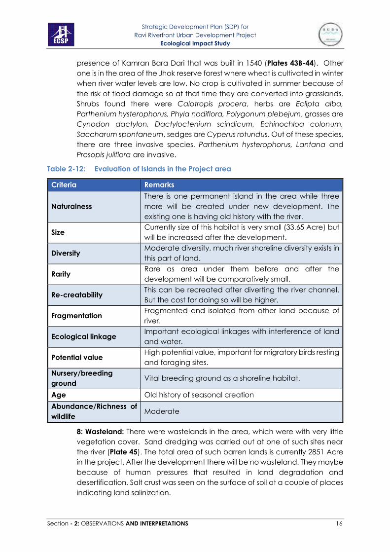
Strategic Development Plan (SDP) for
Ravi Riverfront Urban Development Project
Ecological Impact Study
Section - 2: OBSERVATIONS AND INTERPRETATIONS 16
presence of Kamran Bara Dari that was built in 1540 (Plates 43B-44). Other
one is in the area of the Jhok reserve forest where wheat is cultivated in winter
when river water levels are low. No crop is cultivated in summer because of
the risk of flood damage so at that time they are converted into grasslands.
Shrubs found there were Calotropis procera, herbs are Eclipta alba,
Parthenium hysterophorus, Phyla nodiflora, Polygonum plebejum, grasses are
Cynodon dactylon, Dactyloctenium scindicum, Echinochloa colonum,
Saccharum spontaneum, sedges are Cyperus rotundus. Out of these species,
there are three invasive species. Parthenium hysterophorus, Lantana and
Prosopis juliflora are invasive.
Table 2-12: Evaluation of Islands in the Project area
Criteria Remarks
Naturalness
There is one permanent island in the area while three
more will be created under new development. The
existing one is having old history with the river.
Size Currently size of this habitat is very small (33.65 Acre) but
will be increased after the development.
Diversity Moderate diversity, much river shoreline diversity exists in
this part of land.
Rarity Rare as area under them before and after the
development will be comparatively small.
Re-creatability This can be recreated after diverting the river channel.
But the cost for doing so will be higher.
Fragmentation Fragmented and isolated from other land because of
river.
Ecological linkage Important ecological linkages with interference of land
and water.
Potential value High potential value, important for migratory birds resting
and foraging sites.
Nursery/breeding
ground Vital breeding ground as a shoreline habitat.
Age Old history of seasonal creation
Abundance/Richness of
wildlife Moderate
8: Wasteland: There were wastelands in the area, which were with very little
vegetation cover. Sand dredging was carried out at one of such sites near
the river (Plate 45). The total area of such barren lands is currently 2851 Acre
in the project. After the development there will be no wasteland. They maybe
because of human pressures that resulted in land degradation and
desertification. Salt crust was seen on the surface of soil at a couple of places
indicating land salinization.

Strategic Development Plan (SDP) for
Ravi Riverfront Urban Development Project
Ecological Impact Study
Section - 2: OBSERVATIONS AND INTERPRETATIONS 17
Table 2-13: Evaluation of wastelands in the Project area
Criteria Remarks
Naturalness
Naturally it used to have vegetation cover but due to
human pressure and their activities, now it is converted
into wastelands.
Artificial.
Size Varies from small to large. Overall area of this landuse is
currently 2.79%.
Diversity Diversity of such habitats is low.
Rarity Not very common, but they should be reclaimed to
productive uses.
Re-creatability
This can be recreated easily. But rather than recreating
this site, it should be replanted or used in a development
perspective.
Fragmentation These are in the form of patches in the productive land.
Ecological linkage They were present close to agriculture fields. Some also
had temporary freshwater ponds in it.
Potential value
Such lands have low potential value with respect to
biological diversity. Their economic value is very low but
can be increased after rehabilitation and reclamation.
Nursery/breeding
ground
Their value as a nursery or breeding ground for species is
low.
Age Recent to old
Abundance/Richness
of wildlife
Low, with 26 plant and 33 species of mammals, birds,
reptiles and amphibians.
B) Flora Information
1- Survey for the Floral Inventory of the project area
Plants species in the study area were surveyed by the team using all the major
roads travelling upstream and downstream of Lahore at both sides of river
Ravi first in 2014 and then repeated in January 2021. Plant species on the main
and side roads, orchards, grasslands and agricultural fields were carried out
using 100 m long transect walks. Quadrats of 10 m × 10 m were marked in the
forests and the number of herbs, shrubs and trees present in it were recorded
(Table 7 and Plates 4-23). Long walks along the bank of the river at various
locations helped in describing shoreline vegetation. Islands were reached
through boats. Unknown plants species were collected for the purpose of
identification which were then identified using Floras of Lahore, Punjab and
Pakistan. Help from eflora of Pakistan
(http://www.efloras.org/flora_page.aspx?flora_id=5), IUCN’s red list
(https://www.iucnredlist.org/) and global invasive species database
(http://www.iucngisd.org/gisd/) websites was also taken. Number and types

Strategic Development Plan (SDP) for
Ravi Riverfront Urban Development Project
Ecological Impact Study
Section - 2: OBSERVATIONS AND INTERPRETATIONS 18
of trees, shrubs, and herbs were recorded during the surveys and their IUCN
status was noted afterwards. Few common trees were eucalyptus, seesham,
kikar, beri, toot, dherak, phulai etc. Invasive species included Lantan camara,
Prosopis juliflora and Parthenium in terrestrial ecosystems while Pistia and
Eichhornia crassipes were invasive species of aquatic ecosystems. List of
aquatic plant species present in river or pond is given in Table 2-14 while list
of plants from all other habitats is given in Table 2-15.
Table 2-14: List of plant species collected from ponds and river in the project area.
AQUATIC PLANTS COMMON NAMES
Habitat
s Abundanc
e class
IUCN
STATUS R P
ANGIOSPERMS
Eichhornia crassipes* Water Hyacinth + + A Not
Evaluated
Lemna minor Common
Duckweed - + B
Least
Concern
Pistia stratiotes* Tropical Duck-
Weed + + B
Least
Concern
Potamogeton sp. Pondweed - + D Not
Evaluated
Typha angustata Lesser indian reed
mace - + C
Not
Evaluated
PTERIDOPHYTES
Marsilea villosa Villous Waterclover - + B Not
Evaluated
BRYOPHYTE
Marchantia sp. Liverwort + - D Not
Evaluated
"+" = Present, "-" = Absent, * = Invasive, R= River, P = Pond, A = Very Common, B =
Common & Widespread, C = Less Common, D = Rare, E = Very Rare

Strategic Development Plan (SDP) for
Ravi Riverfront Urban Development Project
Ecological Impact Study
Section - 2: OBSERVATIONS AND INTERPRETATIONS 19
Table 2-15: List of plant species collected from different habitats in the project area.
SCIENTIFIC NAMES COMMON NAMES HABITATS ABUNDAN
CE CLASS
IUCN
STATUS F A + R R. B. O L W K I
TREES
Acacia nilotica Egyptian Thorn + + - + - - + - A Not
Evaluated
Albizia lebbeck Rain Tree + + - - - - + - C Not
Evaluated
Albizia procera Tall Albizia - - - - - - + - E Not
Evaluated
Alstonia scholaris White Cheesewood - - + - - - + - D Least
Concern
Azadirachta indica Neem Tree + - - - - - + - C Not
Evaluated
Bombax ceiba Cotton Tree + + + - - - + - C Not
Evaluated
Broussonetia
papyrifera* Paper Mulberry + + + - - - - - D
Not
Evaluated
Conocarpus spp Mangrove tree + + - - - - + - D -
Cordia myxa Assyrian Plum + + - - - - - - D Not
Evaluated
Cupressus
sempervirens Italian Cypress - - - - - - + - E
Not
Evaluated
Dalbergia sissoo Sissoo Tree + + + + - - + - A Not
Evaluated
Ehretia serrata Koda Tree + - - - - - - - E Not

Strategic Development Plan (SDP) for
Ravi Riverfront Urban Development Project
Ecological Impact Study
Section - 2: OBSERVATIONS AND INTERPRETATIONS 20
SCIENTIFIC NAMES COMMON NAMES HABITATS ABUNDAN
CE CLASS
IUCN
STATUS F A + R R. B. O L W K I
Evaluated
Erythrina suberosa Corky Coral Tree + - - - - - - - E Not
Evaluated
Eucalyptus
camaldulensis Red Gum + + + + - - - - B
Not
Evaluated
Eucalyptus citriodora Spotted Gum + - - - - - + - D Not
Evaluated
Eucalyptus largiflorens Flooded Gum + - - - - - + - D Not
Evaluated
Ficus benghalensis Banyan Fig - + - - - - + - C Not
Evaluated
Ficus carica Fig + + - + - - - - C Least
Concern
Ficus infectoria White Fig - - + + - - - - D Not
Evaluated
Ficus racemosa Cluster Fig - - - - - - + - E Not
Evaluated
Ficus religiosa Peepul Tree + + + + - - + - C Not
Evaluated
Mangifera indica Mango - + - - - - + - D Data
Deficient
Melia azedarach China Berry + + + + - - + - B Not
Evaluated
Mimusops elengi Spanish Cherry - - - - - - + - E Not

Strategic Development Plan (SDP) for
Ravi Riverfront Urban Development Project
Ecological Impact Study
Section - 2: OBSERVATIONS AND INTERPRETATIONS 21
SCIENTIFIC NAMES COMMON NAMES HABITATS ABUNDAN
CE CLASS
IUCN
STATUS F A + R R. B. O L W K I
Evaluated
Morus alba White Mulberry + + + + - - + - B Not
Evaluated
Morus nigra Black Mulberry - + - - - - - - E Not
Evaluated
Musa paradisiaca Banana - + - - - - - - E Not
Evaluated
Nerium oleander Oleander - + - - - - + - E Least
Concern
Parkinsonia aculeate Cambron + + + - - - - - C Not
Evaluated
Phoenix dactylifera Date Palm + - + - - - + - C Not
Evaluated
Platanus orientalis Chinar - - - - - - + - E Not
Evaluated
Pongamia pinnata Indian Beech + + + - - - + - C Least
Concern
Polyalthia longifolia Ashok - - - - - - + - E Not
Evaluated
Populus euphratica Salt Poplar - + - + - - - - D Not
Evaluated
Prosopis cineraria Jand - - - - - - + - E Not
Evaluated
Prosopis juliflora* Mesquite + + + + - - + - B Not

Strategic Development Plan (SDP) for
Ravi Riverfront Urban Development Project
Ecological Impact Study
Section - 2: OBSERVATIONS AND INTERPRETATIONS 22
SCIENTIFIC NAMES COMMON NAMES HABITATS ABUNDAN
CE CLASS
IUCN
STATUS F A + R R. B. O L W K I
Evaluated
Psidium guajava Guava + + - + - - - - C Not
Evaluated
Salix tetrasperma Indian Willow + - - - - - - - D Not
Evaluated
Syzygium cumini Black Plum - + - + - - + - C Not
Evaluated
Tamarix aphylla Athel Pine + - - - - - - - D Not
Evaluated
Terminalia arjuna Arjun Tree + - - - - - + - D Not
Evaluated
Ziziphus jujuba Chinese Date + + + - - - - - C Least
Concern
Ziziphus nummularia Jujube + + + - - - - - C Not
Evaluated
SHRUBS
Abutilon bidentatum Velvetleaf - + - - - - - - E Not
Evaluated
Abutilon hybridum Chinese Bellflower + + - - + - - - C -
Acacia farnesiana Mimosa Bush - + - - - - - - E Not
Evaluated
Atriplex crassifolia Saltbush - + - - - - - - E Not
Evaluated
Bougainvillea Bougainvillea - - - - - - + - E Not

Strategic Development Plan (SDP) for
Ravi Riverfront Urban Development Project
Ecological Impact Study
Section - 2: OBSERVATIONS AND INTERPRETATIONS 23
SCIENTIFIC NAMES COMMON NAMES HABITATS ABUNDAN
CE CLASS
IUCN
STATUS F A + R R. B. O L W K I
spectabilis wild Evaluated
Calotropis procera Rubber bush/ Aak + + + + - - + - B Not
Evaluated
Hibiscus rosa sinensis Shoe Flower - - - - - - + - E Not
Evaluated
Ipomoea carnea Bush Morning Glory + + + - + - - + C Not
Evaluated
Jasminum officinale Jasminum - - - - - - + - E Not
Evaluated
Lantana camara* Big Sage + - + - - - + - C Not
Evaluated
Murraya exotica Orange Jasmine - - - - - - + - E Not
Evaluated
Ricinus communis Castor Oil Plant + + - - - - + - C Not
Evaluated
Rosa indica Rose Bed - - - - - - + - E Not
Evaluated
Sida cordifolia Country Mallow + - - - - - - - E Not
Evaluated
Tamarix dioca Salt Cedar - + + - - - - + D Not
Evaluated
Withania somnifera Indian Ginseng + + + + - - - - C Not
Evaluated
HERBS

Strategic Development Plan (SDP) for
Ravi Riverfront Urban Development Project
Ecological Impact Study
Section - 2: OBSERVATIONS AND INTERPRETATIONS 24
SCIENTIFIC NAMES COMMON NAMES HABITATS ABUNDAN
CE CLASS
IUCN
STATUS F A + R R. B. O L W K I
Agave Americana Century Plant + - - - - - - E Not
Evaluated
Achyranthes aspera Prickly Chaff Flower + + - + - - - - C Not
Evaluated
Alhagi maurorum Camelthorn + - + + - + - - C Not
Evaluated
Alternanthera sessilis Sessile Joyweed + + + - - - - - C Least
Concern
Amaranthus viridis Slender Amaranth + + - + - - - - B Not
Evaluated
Ammannia baccifera. Blistering Ammania - + - - - - - - E Least
Concern
Boerhavia diffusa Red Spiderling + + + - - - - - C Not
Evaluated
Cannabis sativa Marihuana + + - - - - - + C Not
Evaluated
Cassia absus Tropical Sensitive
Pea + + - - - - - - D
Least
Concern
Chenopodium
ambrosioides Mexican Tea + + - - - - - + C
Not
Evaluated
Chenopodium album Lambsquarters + + + - - - - - B Not
Evaluated
Chrozophora tinctoria Dyer's Litmus - + - - - - - - E Least
Concern
Citrullus lanatus Watermelon + + + + - - - + D Not
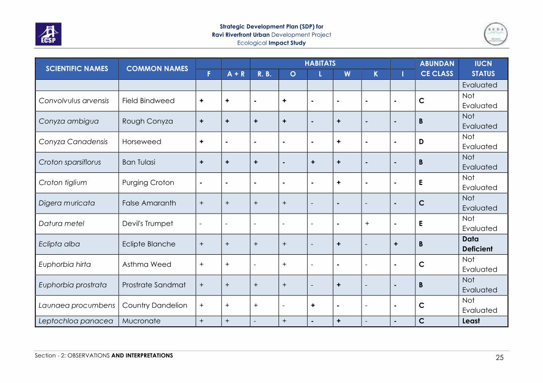
Strategic Development Plan (SDP) for
Ravi Riverfront Urban Development Project
Ecological Impact Study
Section - 2: OBSERVATIONS AND INTERPRETATIONS 25
SCIENTIFIC NAMES COMMON NAMES HABITATS ABUNDAN
CE CLASS
IUCN
STATUS F A + R R. B. O L W K I
Evaluated
Convolvulus arvensis Field Bindweed + + - + - - - - C Not
Evaluated
Conyza ambigua Rough Conyza + + + + - + - - B Not
Evaluated
Conyza Canadensis Horseweed + - - - - + - - D Not
Evaluated
Croton sparsiflorus Ban Tulasi + + + - + + - - B Not
Evaluated
Croton tiglium Purging Croton - - - - - + - - E Not
Evaluated
Digera muricata False Amaranth + + + + - - - - C Not
Evaluated
Datura metel Devil's Trumpet - - - - - - + - E Not
Evaluated
Eclipta alba Eclipte Blanche + + + + - + - + B Data
Deficient
Euphorbia hirta Asthma Weed + + - + - - - - C Not
Evaluated
Euphorbia prostrata Prostrate Sandmat + + + + - + - - B Not
Evaluated
Launaea procumbens Country Dandelion + + + - + - - - C Not
Evaluated
Leptochloa panacea Mucronate + + - + - + - - C Least

Strategic Development Plan (SDP) for
Ravi Riverfront Urban Development Project
Ecological Impact Study
Section - 2: OBSERVATIONS AND INTERPRETATIONS 26
SCIENTIFIC NAMES COMMON NAMES HABITATS ABUNDAN
CE CLASS
IUCN
STATUS F A + R R. B. O L W K I
Sprangletop Concern
Malvastrum
coromandelianum False Mallow + + - + - - - - C
Not
Evaluated
Nicotiana
plumbaginifolia Tex-Mex Tobacco - + + - - - - - E
Not
Evaluated
Oxalis corniculata Sleeping Beauty + + + + - + - - B Not
Evaluated
Oxystelma
esculentum Rosy Milkweed Vine + - - - - + - - D
Least
Concern
Parthenium
hysterophorus* Whitetop Weed + + + - + + - + B
Not
Evaluated
Phyla nodiflora Turkey Tangle
Frogfruit + + + + - - - + B
Least
Concern
Physalis divaricate Ground Cherry - + - - - - - - E Not
Evaluated
Polygonum persicaria Redshank + + + + - - - - C Least
Concern
Polygonum plebejum Small Knotweed + + - - + + - + B Not
Evaluated
Portulaca oleracea Little Hogweed + - - - - - - - E Not
Evaluated
Solanum nigrum Black Nightshade + + + - - - - - C Not
Evaluated
Solanum Thai Eggplant + - - - - + - - D Not
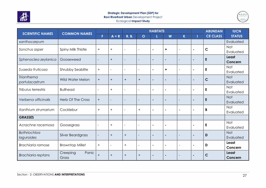
Strategic Development Plan (SDP) for
Ravi Riverfront Urban Development Project
Ecological Impact Study
Section - 2: OBSERVATIONS AND INTERPRETATIONS 27
SCIENTIFIC NAMES COMMON NAMES HABITATS ABUNDAN
CE CLASS
IUCN
STATUS F A + R R. B. O L W K I
xanthocarpum Evaluated
Sonchus asper Spiny Milk Thistle + + - - - + - - C Not
Evaluated
Sphenoclea zeylanica Gooseweed - + - - - - - - E Least
Concern
Suaeda fruticosa Shrubby Seablite + - - - - + - - E Not
Evaluated
Trianthema
portulacastrum Wild Water Melon + + + + - - - - C
Not
Evaluated
Tribulus terrestris Bullhead - + - - - - - - E Not
Evaluated
Verbena officinalis Herb Of The Cross + - - - - - - - E Not
Evaluated
Xanthium strumarium Cocklebur + + - + - - - - B Not
Evaluated
GRASSES
Acrachne racemosa Goosegrass - + - - - - - E Not
Evaluated
Bothriochloa
laguroides Silver Beardgrass - + + - - - - - D
Not
Evaluated
Brachiaria ramose Browntop Millet + - + - - - - - D Least
Concern
Brachiaria reptans Creeping Panic
Grass + + + + - - - - C
Least
Concern

Strategic Development Plan (SDP) for
Ravi Riverfront Urban Development Project
Ecological Impact Study
Section - 2: OBSERVATIONS AND INTERPRETATIONS 28
SCIENTIFIC NAMES COMMON NAMES HABITATS ABUNDAN
CE CLASS
IUCN
STATUS F A + R R. B. O L W K I
Cenchrus ciliaris Buffel Grass + + - - - - - - D Not
Evaluated
Cenchrus setigerus Birdwood Grass + + - + - - - - C Not
Evaluated
Cenchrus
pennisetiformis Cloncurry + - - - - - - - E
Not
Evaluated
Cynodon dactylon Bermuda Grass + + + + + + - + A Not
Evaluated
Dactyloctenium
aegyptium
Egyptian Crowfoot
Grass - + - - - - - - D
Not
Evaluated
Dactyloctenium
scindicum Crowfoot Grass - + + + - - - + B
Not
Evaluated
Desmostachya
bipinnata Halfa Grass + + + + - + - - B
Least
Concern
Digitaria ciliaris Southern Crabgrass - + + + - - - - C Not
Evaluated
Dichanthium
annulatum Marvel Grass + - - + - - - - D
Not
Evaluated
Echinochloa colonum Jungle Rice + + + + - - - + B -
Echinochloa crusgalli Barnyardgrass - + - + - + - - C Least
Concern
Eleusine indica Wiregrass - + - - - - - - E Least
Concern
Eragrostis cilianensis Candy Grass - + - - - - - - E Not
Evaluated
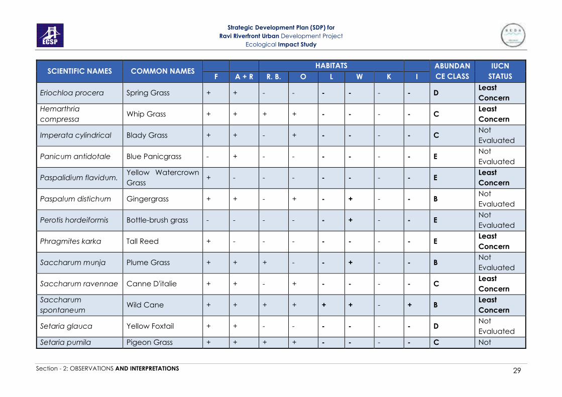
Strategic Development Plan (SDP) for
Ravi Riverfront Urban Development Project
Ecological Impact Study
Section - 2: OBSERVATIONS AND INTERPRETATIONS 29
SCIENTIFIC NAMES COMMON NAMES HABITATS ABUNDAN
CE CLASS
IUCN
STATUS F A + R R. B. O L W K I
Eriochloa procera Spring Grass + + - - - - - - D Least
Concern
Hemarthria
compressa Whip Grass + + + + - - - - C
Least
Concern
Imperata cylindrical Blady Grass + + - + - - - - C Not
Evaluated
Panicum antidotale Blue Panicgrass - + - - - - - - E Not
Evaluated
Paspalidium flavidum. Yellow Watercrown
Grass + - - - - - - - E
Least
Concern
Paspalum distichum Gingergrass + + - + - + - - B Not
Evaluated
Perotis hordeiformis Bottle-brush grass - - - - - + - - E Not
Evaluated
Phragmites karka Tall Reed + - - - - - - - E Least
Concern
Saccharum munja Plume Grass + + + - - + - - B Not
Evaluated
Saccharum ravennae Canne D'italie + + - + - - - - C Least
Concern
Saccharum
spontaneum Wild Cane + + + + + + - + B
Least
Concern
Setaria glauca Yellow Foxtail + + - - - - - - D Not
Evaluated
Setaria pumila Pigeon Grass + + + + - - - - C Not
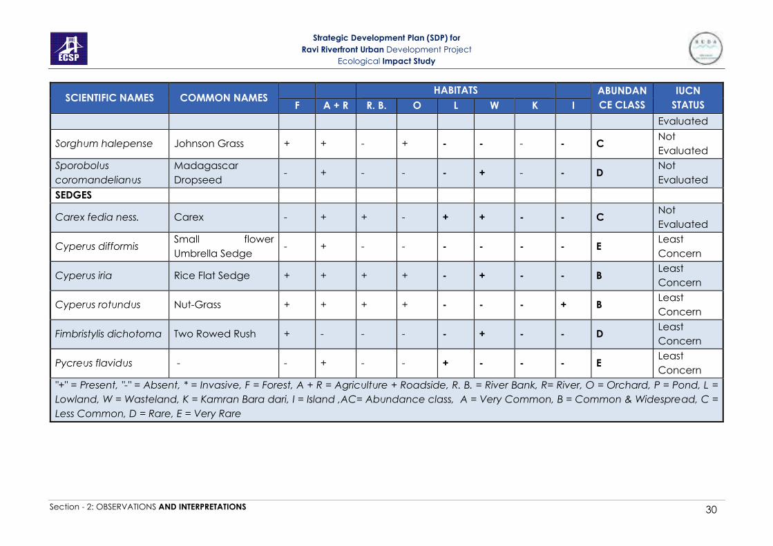
Strategic Development Plan (SDP) for
Ravi Riverfront Urban Development Project
Ecological Impact Study
Section - 2: OBSERVATIONS AND INTERPRETATIONS 30
SCIENTIFIC NAMES COMMON NAMES HABITATS ABUNDAN
CE CLASS
IUCN
STATUS F A + R R. B. O L W K I
Evaluated
Sorghum halepense Johnson Grass + + - + - - - - C Not
Evaluated
Sporobolus
coromandelianus
Madagascar
Dropseed - + - - - + - - D
Not
Evaluated
SEDGES
Carex fedia ness. Carex - + + - + + - - C Not
Evaluated
Cyperus difformis Small flower
Umbrella Sedge - + - - - - - - E
Least
Concern
Cyperus iria Rice Flat Sedge + + + + - + - - B Least
Concern
Cyperus rotundus Nut-Grass + + + + - - - + B Least
Concern
Fimbristylis dichotoma Two Rowed Rush + - - - - + - - D Least
Concern
Pycreus flavidus - - + - - + - - - E Least
Concern
"+" = Present, "-" = Absent, * = Invasive, F = Forest, A + R = Agriculture + Roadside, R. B. = River Bank, R= River, O = Orchard, P = Pond, L =
Lowland, W = Wasteland, K = Kamran Bara dari, I = Island ,AC= Abundance class, A = Very Common, B = Common & Widespread, C =
Less Common, D = Rare, E = Very Rare

Strategic Development Plan (SDP) for
Ravi Riverfront Urban Development Project
Ecological Impact Study
Section - 2: OBSERVATIONS AND INTERPRETATIONS 31
In addition to trees, shrubs and herbs found in different habitats, samples of water
were collected from irrigation channels, rice paddies, ponds and river and were
observed under compound microscope for identification of algae. Following is the
list of algae found in ponds and river during study period.
Table 17: List of algae found in irrigation channels, rice paddies, river and ponds
during the study period.
Species Phylum
Spirogyra Charophyta
Chlorococcum Chlorophyta
Ankistrodesmus Chlorophyta
Ulothrix Chlorophyta
Cladophora Chlorophyta
Oedogonium Chlorophyta
Cosmarium Chlorophyta
Hydrodictyon Chlorophyta
Pandorina Chlorophyta
Oscillatoria Cyanobacteria
Nostoc Cyanobacteria
Anabaena Cyanobacteria
Lyngbya Cyanobacteria
Microcystis Cyanobacteria
Chrococcus Cyanobacteria
Navicula Heterokontophyta
Pinnularia Heterokontophyta
2- Protection status of Plants found in the area
After developing inventory of the plants in each habitat, status of species protection,
distribution and their rarity was evaluated according to the criteria described in Table
2-16.
Table 2-16: Status of plant species recorded within the study area
Criteria Remarks
Protection
Status
None of the species is protected under IUCN Red List of Threatened
Species. Status of most of the species is either not evaluated or least
concern.
Distributio
n
5 are very common, 23 are common and widespread, 46 are less
common, 27 are rare and 45 are very rare in the study area.

Strategic Development Plan (SDP) for
Ravi Riverfront Urban Development Project
Ecological Impact Study
Section - 2: OBSERVATIONS AND INTERPRETATIONS 32
Criteria Remarks
Rarity
No species is rare under IUCN. But the widespread of exotic species like
Parthenium, Lantana, P. juliflora and Paper Mulberry is pushing native
species of trees, shrubs like Calotropis, Ranunculus to become very less
frequent in the area.
C) Fauna Information
1- Fauna survey for developing inventory in the project site
The survey was done in the project area and data was gathered for
mammals, reptiles, birds, amphibians, insects and zooplanktons. A checklist
of the species that might be expected in the study area was prepared by
searching published literature. Both direct observation and indirect methods
were used to gather information. Community surveys were carried out and
data was gathered from the local people regarding information of animals
in the area using field guides and colored photographs. A verification survey
was conducted in the second week of January 2021 to verify the presence
and abundance of the fauna reported during the previous study conducted
in 2014. The survey area was the same as in the previous study to draw a
comparative analysis. The literature review and community survey were also
conducted to ensure that all species which are present or expected to be
present within the study area are reported. The detailed survey included
ecological importance of species, their niche and their IUCN conservation
status; like endangered, threatened, vulnerable etc. Plates (46-51A)
a- Survey of Birds
The methodology adopted for the avifauna survey included line-transect
method, point count, direct observation, and call recognition. The bird survey
was conducted at early morning and evening time, when the bird activity is
maximum. The birds were observed with binoculars (10 x 50) and spotting
scopes, and they were identified with the help of field guide/book Grimmett
et al. (2008). The effective sampling distance was 200 m from transects. While
the recorded data included species identity as well as its relative abundance
in the project area. Table 18 and Figures 4 (a-d) show details of the birds found
in the project area.
b- Survey of Mammals
Mammals were surveyed during the visits and were identified from field
observations of paw prints, scats and their burrows. In consideration of the
nocturnal and elusive behaviour of mammals, the survey methodology
included direct observation, spoor tracking (observations based on
footprints, burrows, den sites etc.) and scat analysis (morphometric analysis
of faecal matter). The species identification was based on the field guides
Roberts (2005a & b). Moreover, the public and the Forest Department Staff
Strategic Development Plan (SDP) for
Ravi Riverfront Urban Development Project
Ecological Impact Study
Section - 2: OBSERVATIONS AND INTERPRETATIONS 33
were also interviewed regarding the presence of mammalian species and
their relative abundance. Table 18 and Figure 5 show details of the mammals
found in the project area.
c- Survey of Reptiles and Amphibians
These field surveys were carried out to locate species and their habitats within
the study area. The morning surveys were conducted in the bright day light
and evening surveys of the same place were also carried out. The
herpetofauna survey was based on active search method and public survey.
Due to winter season in the second survey in January 2021, herp species were
unlikely to be observed through direct observation. However, the active
search method was adopted whereby debris, logs, and riverbank were
searched for direct and indirect observations. Moreover, the public was
interviewed regarding the species presence and their relative abundance.
List of the species is shown in table 19 and figure 6.
Bird species were more abundant along the riverbanks, agricultural fields and
in forest areas. Most common species were Passer domesticus, Corvus
splendens, Acridotheres tristis, Egretta intermedia, and Dicrurus macrocersus
vieillot. Wild boars and jackals were present in the study area. Mostly small
size mammals which included porcupines, rat and bat species were there.
Mammals were mostly found in forests and agriculture fields. Among the
reptiles, Varanus bengalensis, Uromastyx hardwickii and Naja naja etc. were
common. Three species of snakes and two species of turtles are reported.
According to the IUCN red list of threatened species, Nilssonia gangetica is
vulnerable and it needs to be protected. Only three Amphibian species were
found in the study area. Among them, Hoplobatrachus tigrinus and Bufo
stomaticus were very common. None of the species of birds, mammals and
amphibians were found rare in the IUCN lists.

Strategic Development Plan (SDP) for
Ravi Riverfront Urban Development Project
Ecological Impact Study
Section - 2: OBSERVATIONS AND INTERPRETATIONS 34
Table 2-17: List of mammals, birds, reptiles and amphibians of the project area
Animal Species Common name
Habitats
AC IUCN
status
Punjab
Wildlife
Act
CITES A+
R W P R O L F
Birds
Egretta intermedia Intermediate Egret + - + + - + + B LC
Accipiter badius Shikra + - - - - - + D LC
Acridotheres ginginianus Bank Myna + + - - + + + B LC
Acridotheres tristis Common Myna + + + + + + + A LC
Actitis hypoleucos* Common Sand piper + + - + - + + B LC
Amaurornis phoenicurus White breasted hen - - - + - + - D LC
Anas crecca* Common teal - - - + - - - D LC
Anas Platyrhynchos* Mallard - + - - + + + C LC
Ardeola grayii Indian pond Heron + - - - + - + C LC
Bubulcus ibis Cattle egret + - - + + + + C LC
Callacanthis burtoni Spectacle Finch - - + + + + + D LC
Centropus sinensis Crow pheasant + - - - + - + C LC
Ceryle rudis Pied kingfisher + - - + + + + C LC
Cinnyris asiaticus Purple sunbird + - - - + - + D LC
Columba livia Wild rock dove + - - + + + + B LC
Copsychus saularis Magpie robin + - - - + - + C LC
Coracias benghalensis Indian roller + + - - - - + B LC
Corvus splendens House Crow + + + + + + + A LC

Strategic Development Plan (SDP) for
Ravi Riverfront Urban Development Project
Ecological Impact Study
Section - 2: OBSERVATIONS AND INTERPRETATIONS 35
Animal Species Common name
Habitats
AC IUCN
status
Punjab
Wildlife
Act
CITES A+
R W P R O L F
Coturnix coturnix* Common Quail - - - + - - + D LC
Dicrurus macrocersus vieillot Black Drongo + - + + + - + B LC
Dinopium benghalense Golden backed woodpecker + + - - + - + C LC
Egretta garzetta* little egret + - + + + + + B LC
Francolinus pondicerianus Black Partridge + - - - - - + E LC
Francolinus pondicerianus Grey Partridge + + - + + + + C LC
Galerida cristata Crested lark + - - - + + + C LC
Gallinago gallinago* Common snipe - - - + - - - E LC
Gallinula chloropus* Common moorhen - + - + - - + C LC
Gracupica contra Pied myna + + - + + + + D LC
Halcyon smyrnensis White-breasted Kingfisher + - - + + + + B LC
Himantopus himantopus* Black winged stilt + - + + - - - C LC
Hirundo rustica* Common swallow - - - + - - - D LC
Hoplopterus indicus* Red-Wattled Lapwing + + - + + + + B LC
Hydrophasianus chirurgus* white pheasant jacana - - + - - + - E LC
Lanius schach long tailed shrike + - - - - - + C LC
Merops orientalis Green bee eater + + - - - - + C LC
Merops philippinus* Blue tailed bee eater - - - + + + + C LC
Milvus migrans migrans Black kite + - + + + + + A LC
Motacilla alba White wagtail + - - + - + + C LC
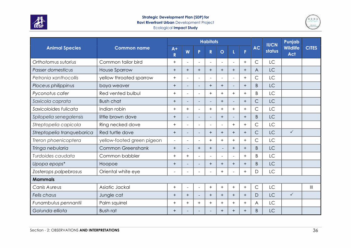
Strategic Development Plan (SDP) for
Ravi Riverfront Urban Development Project
Ecological Impact Study
Section - 2: OBSERVATIONS AND INTERPRETATIONS 36
Animal Species Common name
Habitats
AC IUCN
status
Punjab
Wildlife
Act
CITES A+
R W P R O L F
Orthotomus sutorius Common tailor bird + - - - - - + C LC
Passer domesticus House Sparrow + + + + + + + A LC
Petronia xanthocollis yellow throated sparrow + - - - - - + C LC
Ploceus philippinus baya weaver + - - + + - + B LC
Pyconotus cafer Red vented bulbul + - - + + + + B LC
Saxicola caprata Bush chat + - - - + - + C LC
Saxicoloides fulicata Indian robin + + - + + + + C LC
Spilopelia senegalensis little brown dove + - - - + - + B LC
Streptopelia capicola Ring necked dove + - - - - + + C LC
Streptopelia tranquebarica Red turtle dove + - - + + + + C LC
Treron phoenicoptera yellow-footed green pigeon - - - + + + + C LC
Tringa nebularia Common Greenshank + - + + - + + B LC
Turdoides caudata Common babbler + + - - - - + B LC
Upopa epops* Hoopoe + - - + + + + B LC
Zosterops palpebrosus Oriental white eye - - - - + - + D LC
Mammals
Canis Aureus Asiatic Jackal + - - + + + + C LC III
Felis chaus Jungle cat + + - + + + + D LC
Funambulus pennantii Palm squirrel + + + + + + + A LC
Golunda elliota Bush rat + - - - + + + B LC
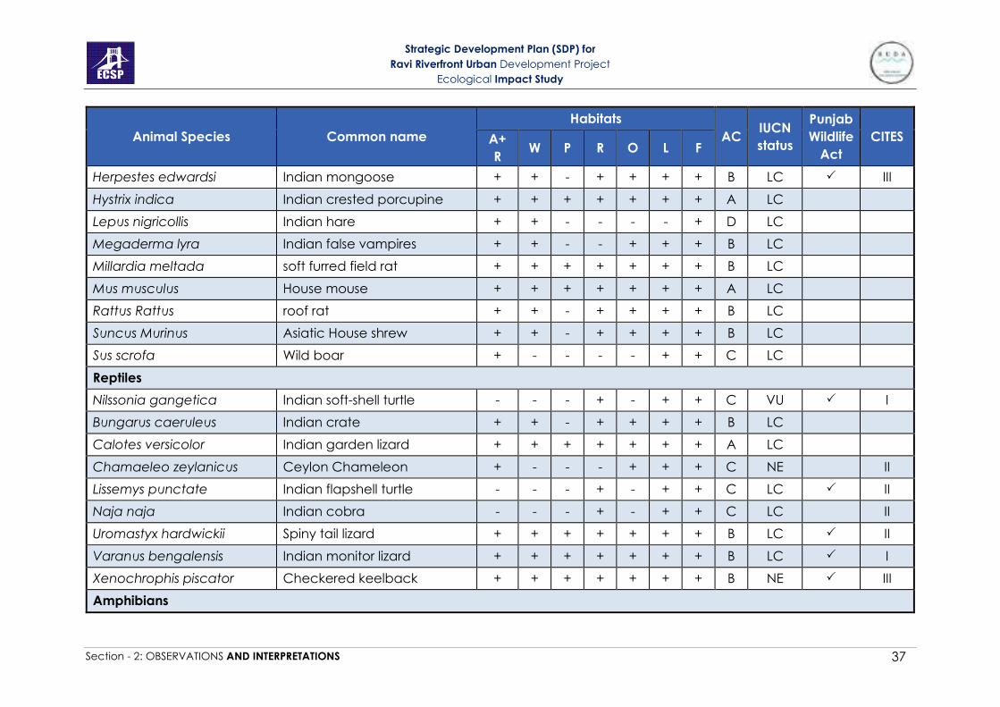
Strategic Development Plan (SDP) for
Ravi Riverfront Urban Development Project
Ecological Impact Study
Section - 2: OBSERVATIONS AND INTERPRETATIONS 37
Animal Species Common name
Habitats
AC IUCN
status
Punjab
Wildlife
Act
CITES A+
R W P R O L F
Herpestes edwardsi Indian mongoose + + - + + + + B LC III
Hystrix indica Indian crested porcupine + + + + + + + A LC
Lepus nigricollis Indian hare + + - - - - + D LC
Megaderma lyra Indian false vampires + + - - + + + B LC
Millardia meltada soft furred field rat + + + + + + + B LC
Mus musculus House mouse + + + + + + + A LC
Rattus Rattus roof rat + + - + + + + B LC
Suncus Murinus Asiatic House shrew + + - + + + + B LC
Sus scrofa Wild boar + - - - - + + C LC
Reptiles
Nilssonia gangetica Indian soft-shell turtle - - - + - + + C VU I
Bungarus caeruleus Indian crate + + - + + + + B LC
Calotes versicolor Indian garden lizard + + + + + + + A LC
Chamaeleo zeylanicus Ceylon Chameleon + - - - + + + C NE II
Lissemys punctate Indian flapshell turtle - - - + - + + C LC II
Naja naja Indian cobra - - - + - + + C LC II
Uromastyx hardwickii Spiny tail lizard + + + + + + + B LC II
Varanus bengalensis Indian monitor lizard + + + + + + + B LC I
Xenochrophis piscator Checkered keelback + + + + + + + B NE III
Amphibians
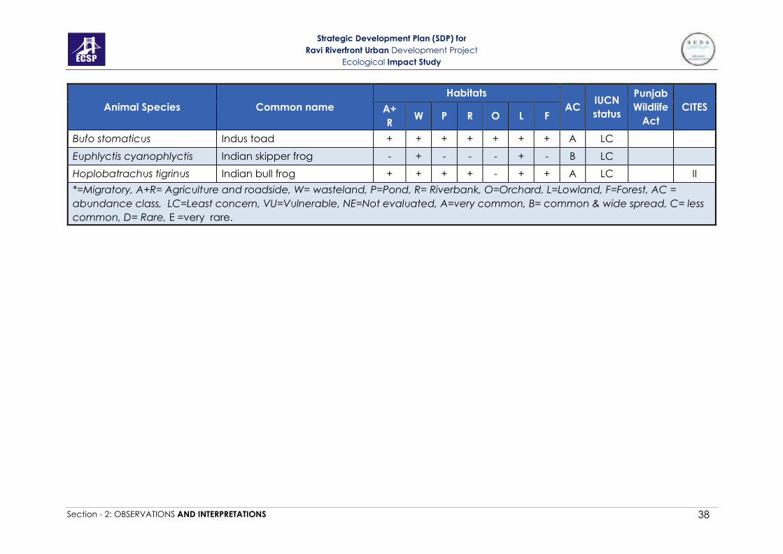
Strategic Development Plan (SDP) for
Ravi Riverfront Urban Development Project
Ecological Impact Study
Section - 2: OBSERVATIONS AND INTERPRETATIONS 38
Animal Species Common name
Habitats
AC IUCN
status
Punjab
Wildlife
Act
CITES A+
R W P R O L F
Bufo stomaticus Indus toad + + + + + + + A LC
Euphlyctis cyanophlyctis Indian skipper frog - + - - - + - B LC
Hoplobatrachus tigrinus Indian bull frog + + + + - + + A LC II
*=Migratory, A+R= Agriculture and roadside, W= wasteland, P=Pond, R= Riverbank, O=Orchard, L=Lowland, F=Forest, AC =
abundance class, LC=Least concern, VU=Vulnerable, NE=Not evaluated, A=very common, B= common & wide spread, C= less
common, D= Rare, E =very rare.

Strategic Development Plan (SDP) for
Ravi Riverfront Urban Development Project
Ecological Impact Study
Section - 2: OBSERVATIONS AND INTERPRETATIONS 39
Table 2-18: Species richness of fauna and flora of the habitat types in the study area.
d- Insect surveys
Insect surveys were carried out using sweep nets, while they were also
identified by direct observations. Because of their well-established status as
indicators of ecosystem health emphasis was given on butterflies. Other
groups included dragonflies, damselflies, and mosquitoes etc. The list of the
species is given in Table-20. Insects were identified with the help of available
literature and keys. Insect guilds are identified with the help of field
observation and available literature (CSIRO, 1991; Triplehorn and Johnson,
2005).
Coleopteran species (Berosus spp. and Hydrophlis spp.) are water scavenger
beetles. Larval stages of Dipteran species (Anopheles spp. and Culex spp.)
occur in ponds while adults are present in forests, lowlands and orchards. They
suck blood of other animals and humans. Female mosquitoes also collect
nectar and honeydew from trees. Larval stages of Chironomid spp. (Diptera)
occur in tree holes filled with water, ponds, stagnant water. Adult stage is
attracted to flowers for pollen and nectar and exist in orchards, lowlands and
forests. Nectar provides good source of energy. Larval stages of Odonata
are present near the bank of river and pond while adult stages can be seen
in orchards, lowlands and forests. Both adult and larval stages of Dragonflies
(Odonata) are voracious predators, feeding on the living prey. Insects
belonging to Hemiptera (Hydrometra spp.) are present in ditches, swamps
and ponds. It moves on the surface of water and eats mosquito larvae and
water fleas. Lepidopteran species play an important role of pollination and
can be seen in agricultural fields, lowlands, orchards and forests.
Habitat types Birds Mammals Reptiles Amphibians Plants
Agriculture and
roadside 41 13 6 2 99
Wasteland 15 10 5 3 26
Pond 11 4 4 2 5
Riverbank 32 9 8 2 53
Orchard 32 11 6 2 49
Lowland 29 12 9 3 10
Forest 47 13 9 2 94

Strategic Development Plan (SDP) for
Ravi Riverfront Urban Development Project
Ecological Impact Study
Section - 2: OBSERVATIONS AND INTERPRETATIONS 40
Table 2-19: List of insect species identified in different habitats
Scientific name Common name Habitats
AC IUCN
status A+ R W P R O L F
Order Coleoptera
Berosus sp Beetle - - + - - - - C NE
Hydrophilus sp Beetle - - + - - - - B NE
Order Diptera
Anopheles sp Mosquitoe - - La - A A A B NE
Chironomid sp Non-biting midges - - La La A + A C NE
Musca domestica house fly + + - - + + + A NE
Culex sp Mosquitoe - - La - A A A B LC
Order Hemiptera
Hydrometra sp Bug - - + - - - - E NE
Order Odonata
Crocothemis
erythraea Scarlet Dragonfly A - La - A - A A NE
Ishnura forcipate N/A A - La - A - A A NE
Orthetrum anceps N/A A - La - A - A B NE
Orthetrum Sabina Slender Skimmer A - La - A - A B NE
Pantala flavescens Wandering Glider A - La - A - A A NE
Order Lepidoptera
Agriopis marginaria Dotted Border + - - - + - + B NE
Catoprilia pyranthe Mottled Emigrant + - - - + - + B NE

Strategic Development Plan (SDP) for
Ravi Riverfront Urban Development Project
Ecological Impact Study
Section - 2: OBSERVATIONS AND INTERPRETATIONS 41
Scientific name Common name Habitats
AC IUCN
status A+ R W P R O L F
Colotis amata
Fabricius Small Salmon Arab + - - - + - + E NE
Cynthia cardui Painted Lady + - - - + - + D NE
Danaus chrysippus African Monarch + - - - + - + A NE
Junonia almanac Peacock Pansy + - - - + - + D NE
Nomophila
neararctica Lucerne Moth + - - - + - + B NE
Papilio demoleus Lime Butterfly + - - - + - + A NE
Pieris canidia the indian cabbage
white + - - - + - + B NE
Pieris napi Green veined white + - - - + - + B NE
Spodoptera litura Oriental Leaf worm
Moth + - - - + - + C NE
Zizeeria maha Pale Grass Blue + - - - + - + A NE
A+R= Agriculture and roadside, W= wasteland, P=Pond, R= Riverbank, O=Orchard, L=Lowland, F=Forest, LC=Least concern,
NE=Not evaluated, A=Adult, Las=Larvae, AC = Abundance Class, A = Very common, B = Common & widespread, C = less
common, D = rare, E =very rare
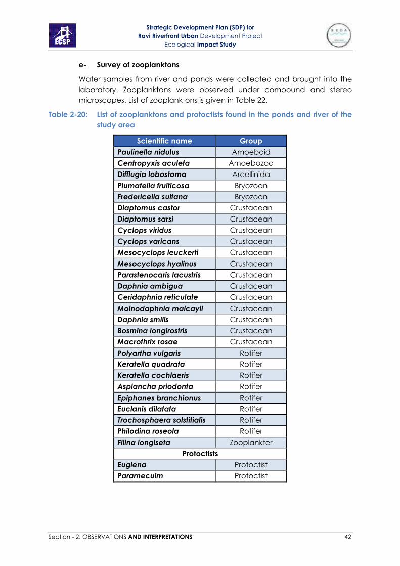
Strategic Development Plan (SDP) for
Ravi Riverfront Urban Development Project
Ecological Impact Study
Section - 2: OBSERVATIONS AND INTERPRETATIONS 42
e- Survey of zooplanktons
Water samples from river and ponds were collected and brought into the
laboratory. Zooplanktons were observed under compound and stereo
microscopes. List of zooplanktons is given in Table 22.
Table 2-20: List of zooplanktons and protoctists found in the ponds and river of the
study area
Scientific name Group
Paulinella nidulus Amoeboid
Centropyxis aculeta Amoebozoa
Difflugia lobostoma Arcellinida
Plumatella fruiticosa Bryozoan
Fredericella sultana Bryozoan
Diaptomus castor Crustacean
Diaptomus sarsi Crustacean
Cyclops viridus Crustacean
Cyclops varicans Crustacean
Mesocyclops leuckerti Crustacean
Mesocyclops hyalinus Crustacean
Parastenocaris lacustris Crustacean
Daphnia ambigua Crustacean
Ceridaphnia reticulate Crustacean
Moinodaphnia malcayii Crustacean
Daphnia smilis Crustacean
Bosmina longirostris Crustacean
Macrothrix rosae Crustacean
Polyartha vulgaris Rotifer
Keratella quadrata Rotifer
Keratella cochlaeris Rotifer
Asplancha priodonta Rotifer
Epiphanes branchionus Rotifer
Euclanis dilatata Rotifer
Trochosphaera solstitialis Rotifer
Philodina roseola Rotifer
Filina longiseta Zooplankter
Protoctists
Euglena Protoctist
Paramecuim Protoctist

Strategic Development Plan (SDP) for
Ravi Riverfront Urban Development Project
Ecological Impact Study
Section - 2: OBSERVATIONS AND INTERPRETATIONS 43
f- Fish survey
Fish surveys were conducted in the main channel of river Ravi with the help
of local fishermen using nets. These nets were deployed at different sites for
30 minutes to one hour during the vegetation survey of the nearby
community. Fishermen were also interviewed to collect information on the
river fish in the study site. List of fish species found in the river are shown in
Table 2-21.
Table 2-21: List of the fish species found in the river Ravi.
Scientific Names Common Names IUCN status
Catla catla Thaila/Indian carp LC
Channa marulius Saul LC
Channa punctate Daula LC
Cirrhinus mrigala Mori LC
Ctenopharyngodon idella † Grass carp NE
Cyprinus carpio*† Common carp/Gulfam VU
Hypopthalmichthys molitrix † Silver carp NT
Hypophthalmichthys nobilis † Big head carp DD
Labeo rohita Rohu LC
Macrognathus pancalus Groj LC
Oreochromis aureus* Tilapia NE
Rita rita Khagga/Tirkanda LC
Sperata sarwari Singharee LC
Wallago attu Mullee VU
LC=Least concern, VU=Vulnerable, NT=Near threatened, DD= Data deficient, NE=
Not evaluated, * = invasive, † exotic

Strategic Development Plan (SDP) for
Ravi Riverfront Urban Development Project
Ecological Impact Study
Section - 2: OBSERVATIONS AND INTERPRETATIONS 44
Figure 2-4 (a): Birds of the study area

Strategic Development Plan (SDP) for
Ravi Riverfront Urban Development Project
Ecological Impact Study
Section - 2: OBSERVATIONS AND INTERPRETATIONS 45
Figure 2-5 (b): Birds of the study area

Strategic Development Plan (SDP) for
Ravi Riverfront Urban Development Project
Ecological Impact Study
Section - 2: OBSERVATIONS AND INTERPRETATIONS 46
Figure 2-6 (c): Birds of the study area

Strategic Development Plan (SDP) for
Ravi Riverfront Urban Development Project
Ecological Impact Study
Section - 2: OBSERVATIONS AND INTERPRETATIONS 47
Figure 2-7 (d): Birds of the study area

Strategic Development Plan (SDP) for
Ravi Riverfront Urban Development Project
Ecological Impact Study
Section - 2: OBSERVATIONS AND INTERPRETATIONS 48
Figure 2-8: Mammals of the studuy area

Strategic Development Plan (SDP) for
Ravi Riverfront Urban Development Project
Ecological Impact Study
Section - 2: OBSERVATIONS AND INTERPRETATIONS 49
Figure 2-9: Reptiles and Amphibians of the study area
2- Protection status of all Animals found in the area
After evaluating habitats and developing fauna’s inventory in each case, status of
protection was evaluated for the species of mammals, amphibians, reptiles and birds
according to the criteria described in Table-4. Following is the detail of mammals in
the study area those are evaluated on their distribution, protection status and rarity.
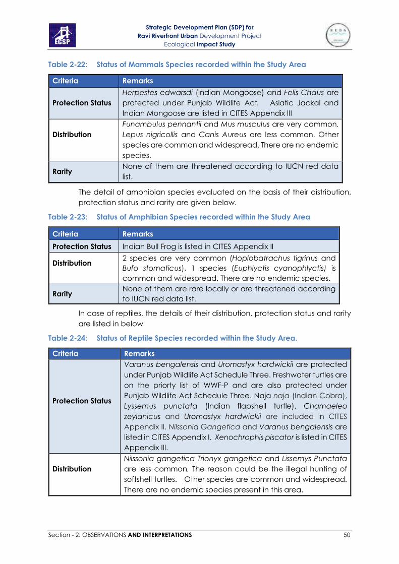
Strategic Development Plan (SDP) for
Ravi Riverfront Urban Development Project
Ecological Impact Study
Section - 2: OBSERVATIONS AND INTERPRETATIONS 50
Table 2-22: Status of Mammals Species recorded within the Study Area
Criteria Remarks
Protection Status
Herpestes edwarsdi (Indian Mongoose) and Felis Chaus are
protected under Punjab Wildlife Act. Asiatic Jackal and
Indian Mongoose are listed in CITES Appendix III
Distribution
Funambulus pennantii and Mus musculus are very common.
Lepus nigricollis and Canis Aureus are less common. Other
species are common and widespread. There are no endemic
species.
Rarity None of them are threatened according to IUCN red data
list.
The detail of amphibian species evaluated on the basis of their distribution,
protection status and rarity are given below.
Table 2-23: Status of Amphibian Species recorded within the Study Area
Criteria Remarks
Protection Status Indian Bull Frog is listed in CITES Appendix II
Distribution
2 species are very common (Hoplobatrachus tigrinus and
Bufo stomaticus), 1 species (Euphlyctis cyanophlyctis) is
common and widespread. There are no endemic species.
Rarity None of them are rare locally or are threatened according
to IUCN red data list.
In case of reptiles, the details of their distribution, protection status and rarity
are listed in below
Table 2-24: Status of Reptile Species recorded within the Study Area.
Criteria Remarks
Protection Status
Varanus bengalensis and Uromastyx hardwickii are protected
under Punjab Wildlife Act Schedule Three. Freshwater turtles are
on the priorty list of WWF-P and are also protected under
Punjab Wildlife Act Schedule Three. Naja naja (Indian Cobra),
Lyssemus punctata (Indian flapshell turtle), Chamaeleo
zeylanicus and Uromastyx hardwickii are included in CITES
Appendix II. Nilssonia Gangetica and Varanus bengalensis are
listed in CITES Appendix I. Xenochrophis piscator is listed in CITES
Appendix III.
Distribution
Nilssonia gangetica Trionyx gangetica and Lissemys Punctata
are less common. The reason could be the illegal hunting of
softshell turtles. Other species are common and widespread.
There are no endemic species present in this area.

Strategic Development Plan (SDP) for
Ravi Riverfront Urban Development Project
Ecological Impact Study
Section - 2: OBSERVATIONS AND INTERPRETATIONS 51
Rarity Nilssonia gangetica is graded as vulnerable on IUCN Red List
of threatened species.
The distribution, protection status and rarity of birds evaluated in the study
area are as follows
Table 2-25: Status of Birds Species recorded within the Study Area
Criteria Remarks
Protection Status
Egretta Intermedia, Streptopelia tranquebarica, Bubulcis ibis,
Anas platyrhynchos, Milvis migrans migrans, Hydrophasianus
chirurgus, Amaurorinus phoenicurus and Ardeola grayii are
listed in Punjab Wildlife Act Schedule III. Himantopus himantopus
is protected under UNEP’s Agreement on the Conservation of
African-Eurasian Migratory Waterbirds of ‘Convention on
migratory species’
Distribution
4 species are very common, 11 species are common and
widespread, 20 species are less common, 8 are uncommon.
There is no endemic species in this area.
Rarity None of the species are rare according to IUCN red data list.
2.2 SECTION-2 ECOLOGICAL MAPPING OF THE STUDY AREA
Biodiversity map of the protected species and their linkage with their habitats
is presented in Figure 7
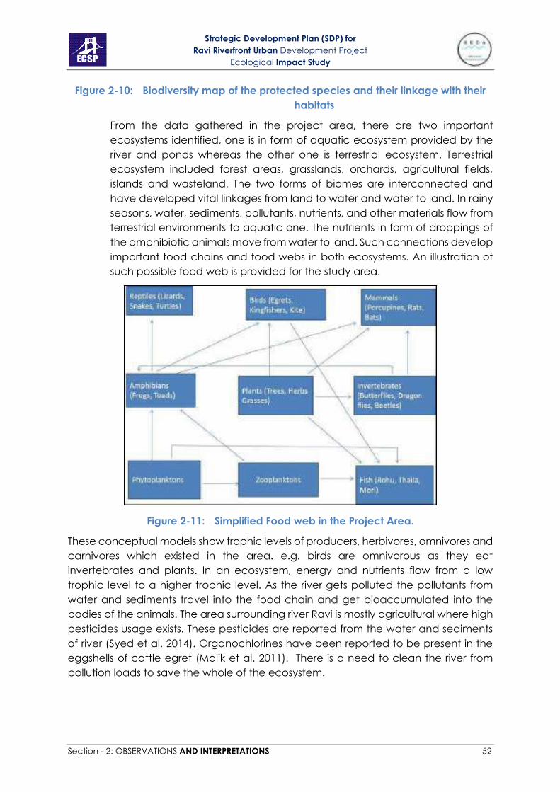
Strategic Development Plan (SDP) for
Ravi Riverfront Urban Development Project
Ecological Impact Study
Section - 2: OBSERVATIONS AND INTERPRETATIONS 52
Figure 2-10: Biodiversity map of the protected species and their linkage with their
habitats
From the data gathered in the project area, there are two important
ecosystems identified, one is in form of aquatic ecosystem provided by the
river and ponds whereas the other one is terrestrial ecosystem. Terrestrial
ecosystem included forest areas, grasslands, orchards, agricultural fields,
islands and wasteland. The two forms of biomes are interconnected and
have developed vital linkages from land to water and water to land. In rainy
seasons, water, sediments, pollutants, nutrients, and other materials flow from
terrestrial environments to aquatic one. The nutrients in form of droppings of
the amphibiotic animals move from water to land. Such connections develop
important food chains and food webs in both ecosystems. An illustration of
such possible food web is provided for the study area.
Figure 2-11: Simplified Food web in the Project Area.
These conceptual models show trophic levels of producers, herbivores, omnivores and
carnivores which existed in the area. e.g. birds are omnivorous as they eat
invertebrates and plants. In an ecosystem, energy and nutrients flow from a low
trophic level to a higher trophic level. As the river gets polluted the pollutants from
water and sediments travel into the food chain and get bioaccumulated into the
bodies of the animals. The area surrounding river Ravi is mostly agricultural where high
pesticides usage exists. These pesticides are reported from the water and sediments
of river (Syed et al. 2014). Organochlorines have been reported to be present in the
eggshells of cattle egret (Malik et al. 2011). There is a need to clean the river from
pollution loads to save the whole of the ecosystem.
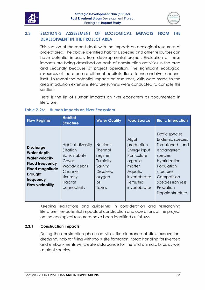
Strategic Development Plan (SDP) for
Ravi Riverfront Urban Development Project
Ecological Impact Study
Section - 2: OBSERVATIONS AND INTERPRETATIONS 53
2.3 SECTION-3 ASSESSMENT OF ECOLOGICAL IMPACTS FROM THE
DEVELOPMENT IN THE PROJECT AREA
This section of the report deals with the impacts on ecological resources of
project area. The above identified habitats, species and other resources can
have potential impacts from developmental project. Evaluation of these
impacts are being described on basis of construction activities in the area
and secondly because of project operation. The significant ecological
resources of the area are different habitats, flora, fauna and river channel
itself. To reveal the potential impacts on resources, visits were made to the
area in addition extensive literature surveys were conducted to compile this
section.
Here is the list of Human impacts on river ecosystem as documented in
literature.
Table 2-26: Human Impacts on River Ecosystem.
Flow Regime Habitat
Structure Water Quality Food Source Biotic Interaction
Discharge
Water depth
Water velocity
Flood frequency
Flood magnitude
Drought
frequency
Flow variability
Habitat diversity
Siltation
Bank stability
Cover
Woody debris
Channel
sinuosity
Habitat
connectivity
Nutrients
Thermal
regime
Turbidity
Salinity
Dissolved
oxygen
pH
Toxins
Algal
production
Energy input
Particulate
organic
matter
Aquatic
invertebrates
Terrestrial
invertebrates
Exotic species
Endemic species
Threatened and
endangered
species
Hybridization
Population
structure
Competition
Species richness
Predation
Trophic structure
Keeping legislations and guidelines in consideration and researching
literature, the potential impacts of construction and operations of the project
on the ecological resources have been identified as follows:
2.3.1 Construction impacts
During the construction phase activities like clearance of sites, excavation,
dredging, habitat filling with spoils, site formation, riprap handling for riverbed
and embankments will create disturbance for the wild animals, birds as well
as plant species.
Strategic Development Plan (SDP) for
Ravi Riverfront Urban Development Project
Ecological Impact Study
Section - 2: OBSERVATIONS AND INTERPRETATIONS 54
A) Permanent loss of habitat
Due to the construction and site clearance, few habitats will be totally lost
e.g. the river shoreline. This will totally diminish the plant species growing on
the shoreline of river Ravi. In addition, water-land interface is necessary for
many amphibians which will be destroyed due to formation of concrete
walls. Many reptiles like freshwater turtles use these areas as their nesting sites
and doing so will seriously affect the population of species that are already
under threat.
As planned in the new development that the width of the river will be fixed
whereas in natural flow the rivers do not have a uniform width. This will bring
an extra 2.32% area under the river that will be achieved by clearing many
adjacent habitats. Almost all area of Anno Bhatti Forest and half of Korotana
Forest will thus be lost.
Larger areas of land under agriculture will be totally lost while some of the
orchard areas will also be lost. This will cause pressure on the supply of fruits
and vegetables to Lahore city which then will have to be transported from
far off areas and will result in their increased prices and shortage.
B) Amplified Fragmentation
During construction phase, controlling the flow of water while creating islands
in the river body, construction of barrages and river wall will affect water flow
ultimately affecting aquatic life. Construction activities will cause
fragmentation and isolation of existing habitats. They may cause hindrance
in movement of biota across different landscape patches for searching food,
breeding or other purposes. Reduced mobility of animals may cause loss of
metapopulation structure resulting in population decline and local extinction.
C) Habitat damage
Due to the construction in the project site, direct, indirect or temporary
damages will occur from site excavation and clearance and dumping spoils
in other habitats. Transportation during construction process will also destroy
wilderness of the area. Most of the agricultural land will be damaged due to
construction in the site
D) Soil erosion
Due to excavation and site clearance, soil will be exposed and eroded. As a
result of this soil erosion, there will be more soil deposition with runoff in
riverbed which will increase eutrophication and sediment loads in the river.
Aquatic life can face stress from high turbidity of suspended soil particles
which will reduce light penetration affecting primary production, and reduce
visibility of aquatic animals. High sediment loads can clog gills of the fish.
Furthermore, eutrophication can deplete dissolved oxygen of the water
bodies providing more stress to fish and other aquatic macrophytes.
Strategic Development Plan (SDP) for
Ravi Riverfront Urban Development Project
Ecological Impact Study
Section - 2: OBSERVATIONS AND INTERPRETATIONS 55
E) Wildlife disturbance and Noise pollution
Wilderness is a trait of wild areas which are far from the urban areas. Urban
areas display lots of population, roads traffic, congestion, sounds of
machines, etc. The forest areas close to the riverbank exhibit trait of
wilderness. Due to construction in this area, human disturbance to
ecosystems will be highest to the wild animals and birds especially. The
severity of this disturbance totally depends upon duration of activity in the
site, its intensity and frequency. Many mammals and birds can be more
disturbed by presence of workers, loud noises and operational construction
plants.
F) Cutting down riparian vegetation
The removal of this vegetation leads to increased water temperature and
changes in river ecosystems. The absence of riparian belt of vegetation
leads to unhindered passage of nutrients into the river. Where this vegetation
belt is intact up to 90% of the nutrients are captured and absorbed before
reaching the river. The roots of plants and especially those of trees have an
important structural role on the reinforcement of riverbanks because they
retain the soil particles and prevent the water from carrying them away.
G) River channelization
River Channelization - is the process of planned human intervention in the
course, characteristics or flow of a river with the intention of producing some
defined benefit. Flowing water is an essential feature of a river. It determines
the capacity to erode and transport sediments and governs ecological
processes so that lotic communities form open rather than closed systems.
Changes to a river’s flow regime therefore are likely to have profound
consequences. Channelization has several predictable and negative effects
• Loss of wetlands because of construction of embankments is one of
the important effects of river channelization. In the current project the
last 6-7 km of the river channel will be kept natural without the
construction of embankments. That will allow flooding of the Phase 3
area during rainy seasons, where many freshwater ponds are planned
to compensate the loss of wetland habitats.
• Although the current development aims to maintain the natural
meander of the river but fixing the river width will reduce meander and
cause straightening of river as compared to its natural course.
Straightening causes the streams to flow more rapidly, which can, in
some instances, vastly increase soil erosion. All of this results in faster
water flow and higher water levels during floods. The faster flow itself
results in intensified erosion of both the riverbanks and bottom, i.e. the
river starts “eating” its own bed and digs into the ground until it reaches
harder bedrock. The increased erosion results in higher water turbidity,

Strategic Development Plan (SDP) for
Ravi Riverfront Urban Development Project
Ecological Impact Study
Section - 2: OBSERVATIONS AND INTERPRETATIONS 56
which is a big problem for all aquatic organisms because it reduces
the penetration of sunlight into the water. Fine particles clog to the gills
of the animals that breathe dissolved oxygen.
• Another, even more serious problem related to riverbed incision is the
lowering of groundwater levels. The river and neighbouring
groundwater are interconnected bodies, and the drop of water levels
in the river (in some cases down 5 or 6 m) leads to a parallel decrease
in the groundwater level because the river acts as a draining channel.
The lowering of groundwater level result in withering of riparian trees
and dry wells and boreholes.
H) Effect of Barrages on river ecology
Many studies have proved that creation of barrages or dams in river channels
effect ecology of river, especially fish. As fish needs instream flow of water
which is disturbed by barrages and hence affect spawning and food
activities of these fauna. The construction of a dam, for example, affects the
transport of water and sediment, so that the local hydrological equilibrium is
upset, and the effects spread through the community, causing a general
ecological transition. These responses are an important focus of modern river
ecology. Juvenile fish would be affected by altered flow of water. The
fragmentation of aquatic and riparian habitats and isolation of associated
populations results in the deterioration of ecological integrity and loss of
important ecosystem services (Dynesius and Nilsson, 1994). The instream
barriers restrict the migration of ichthyofauna to the upstream, wintering and
spawning habitats (Irving & Modde, 2000). The alteration in flow frequency
and magnitude can change the periphyton communities (algal and
cyanobacterial communities) in river (Biggs, 2000). The periphyton
community is not only the primary source of oxygen, food and energy for the
higher trophic level in water, but these are also important indicators of water
quality. The change in downstream hydrology and geomorphology may
result in the larval and juvenile mortality at water intakes (Benstead et al.
1999).
Extensive studies have been conducted to evaluate the impact of barriers
such as barrages and dams which disrupt the longitudinal connectivity of
rivers and consequently obstruct the fish movement to their feeding and
spawning grounds thereby also limiting dispersal (Van Puijenbroek et al., 2019;
Barbarossa et al., 2020). The barriers alter morphology, hydrology, and
function of the freshwater ecosystem. The resulting fragmentation and
isolation results in a major shift in species distribution and abundance (Poff
and Schmidt, 2016). Thus, construction of such barriers is considered a major
threat to the freshwater biodiversity (Reid et al., 2019). Moreover, reduction in
dissolved oxygen levels in the stagnant water usually makes it unsuitable for
the survival of the resident fish fauna (Welcomme, 1985). Another major

Strategic Development Plan (SDP) for
Ravi Riverfront Urban Development Project
Ecological Impact Study
Section - 2: OBSERVATIONS AND INTERPRETATIONS 57
environmental impact on the fish fauna is triggered during the construction
phase of barriers. The soil and silt erosion during excavation activities
degrades the water quality which lead to toxicity to fish. Moreover, the soil
and silt runoff also threaten the breeding/spawning grounds in the river.
Furthermore, the use of explosives during excavation process also creates
blast shocks which are in turn lethal for the fish population within its range
(Bernacsek, 2001).
Fish ladders can also have higher mortality rates, depending on the success
of the design, and also fish may avoid them. Those fish that successfully
negotiate the barrage structure, would then pass into the calmer basin where
the change in current flows, sedimentation, directional clues and predation
could either benefit or disbenefit differing species (The Severn Barrage, 2007).
There are two categories of threats to fish:
Direct: injury and mortality due to strikes and water conditions (for example
water pressure) resulting in damage or disorientation.
Indirect: loss and degradation of habitat which may be important for feeding
and spawning; and disruption to movement.
The most drastic impact of constructing barriers such as barrages is the loss of
land, which includes forests, marshes, etc, which serve as a habitat to a large
number of bird and animal species. The disturbance during reservoir
construction activity, the noise, light, presence of construction workers, etc.
disturb the wild animals, which consequently attempt to escape to distant
habitats. Moreover, the habitat destruction causes wide-spread migration to
new environments where if the species fail to adapt, they risk extinction (Liao
et al., 1988). The construction of barrages dramatically changes the river
hydrological regime and thus in turn alter the migratory pathways of
waterbirds as well. The negative impact of river barriers on the abundance
and distribution of fauna, including birds (including waterfowls), fishes,
macroinvertebrates and zooplankton) has already been recognized (Poff &
Zimmerman, 2010). The selection of a water body as a stop-over or wintering
ground depends on the food availability, predation and disturbance
(Newton, 2010). The construction of barriers changes the vegetation
dynamics, macroinvertebrate habitat and fish abundance and diversity
(Liermann et al. 2012), consequently, altering the food availability for the
migrating water birds as well (Zeng et al., 2017).
After construction of the barrage the habitat of the reservoir borders are
forever altered from their pre-existing state due to difference in lentic and
lotic conditions, seasonal flooding and water quality. Moreover, the
increased water turbidity due to increased erosion and sedimentation, and
decreased photosynthesis of planktons and submerged plants dramatically
reduces primary productivity. The reduction in turn affects freshwater

Strategic Development Plan (SDP) for
Ravi Riverfront Urban Development Project
Ecological Impact Study
Section - 2: OBSERVATIONS AND INTERPRETATIONS 58
chelonians due to decrease in food availability. The freshwater turtles have
feeding and nesting habitat at the riverbanks. As they are extremely
vulnerable to noise and disturbance, the construction activity and human
disturbance results in a drastic decline in their population (Alho, 2011).
I) Concrete boundary of river
Riverbanks are used as corridor for bridging land and terrestrial life. These
banks should be as natural as possible of earthen material, grass concrete or
pebbles rather than concrete. The concrete boundary will act as a barrier for
many amphibians and reptiles that use the sandy banks of the river.
J) Island creation
There are three islands proposed in the project area that will be artificially
created in phase I, II, and III. Creating new islands will be a fruitful idea if it will
provide shoreline and terrestrial habitat to birds and other species. Creation
of islands will mean diverting river water to an artificially constructed channel
that can lead to reduced water flows in the main channel.
2.3.2 Operational impacts
Operational impacts are impacts which are expected after completion and
regulation of the project.
A) Habitat Loss and degradation
After completion of the project, many habitats will be totally diminished e.g.
vegetation on the riverbank, seasonally flooded grasslands and most of the
agricultural fields. Therefore, vegetation of these particular habitats will be
lost. There will be more fragmentation in the natural habitats due to road
network in the area. Suburban areas around Lahore city produce seasonal
vegetables that are sent to markets in Lahore. Fertile alluvial soils of this area
also provide cereals and fruits to Lahore city and development on this land
will mean loss of productive land on which many people depend for their
livelihoods. According to the master plan area for Eco-village has been set
aside in phase 3 of the project that will have fields and orchards. This area will
also have freshwater ponds that will add up to habitat heterozygosity and will
support native biological diversity. Urban agriculture and food production in
this eco-village can in part compensate for loss of this habitat and tackle food
supply issues.
B) Ecological barriers
On completion of the project, the width of the river will be fixed to 1 km with
concrete banks. As a result, this will be an ecological barrier to terrestrial
animals, predatory mammals, juvenile birds and other wild animals.
Strategic Development Plan (SDP) for
Ravi Riverfront Urban Development Project
Ecological Impact Study
Section - 2: OBSERVATIONS AND INTERPRETATIONS 59
C) Noise and air pollution due to urbanization
Due to the development in the area, urban life will create big burden on
natural resources. Human interruption and activities in the form of business
centers, universities, residential colonies and movement of vehicles etc. will
degrade naturalness of the area. Therefore, after operation more noise and
air pollution will result.
D) Light pollution
Another important operational impact on wildlife will be from lights in urban
areas. Wild animals are used to conditions of wild that is low noise, low lights
and naturalness. With this mega construction in the area, and lots of lights
from urban, residential, commercial and transportation pressure, many wild
animals will be forced to leave their wild sites. Light pollution affects human
health by disrupting circadian rhythm. Nocturnal animals such as bats suffer
greatly, causing a decrease in population, difficulties with finding food,
exposure to predators, and an increase in mortality. Insects such as moths
and flies suffer a decrease in population due to light pollution because of
strikes and it is easier for predators to hunt the insects. The decreased insect
population impacts all the animals that feed on insects as their main food
source. Large numbers of birds die from collisions with lighted buildings. The
lighted buildings attract them. Migrating birds don’t reach their destination
because the artificial lights interfere with their navigation and can throw them
off course. Light pollution alters the day/night patterns in animals, resulting in
not getting enough sleep, not having enough down time for the body to
repair itself, and altered reproductive cycles.

Strategic Development Plan (SDP) for
Ravi Riverfront Urban Development Project
Ecological Impact Study
Section - 2: OBSERVATIONS AND INTERPRETATIONS 60
Figure 2-12: Ecological and astronomical light pollution (Longcore and Rich 2004).
E) Bird Collisions and strikes
There are special problems posed for birds living in or flying through cities.
Research has documented that buildings and windows are the top killer of
wild birds (Klem 2009; Gelb and Delacretaz 2009). This toll strikes
indiscriminately culling some of the healthiest of the species. Between one
and five percent of the total migratory population die in window crashes
annually (Klem, 2009). Building collisions pose further risk to endangered or
threatened species whose populations are already declining due to habitat
loss, toxin loads, and other severe environmental pressures. Juvenile residents
and migrants of all ages — those least familiar with the urban setting — face
the greatest risk of injury or death from the hazards of the city environment.
Collision hazards include vehicles, bridges, transmission towers, power lines,
and turbines, but the majority of avian deaths and injuries occur from impacts
with building components such as transparent or reflective glass. Night-time
lighting also interferes with avian migrations. Building collisions are a threat of
sufficient magnitude to affect the viability of bird populations, leading to
local, regional, and national declines.
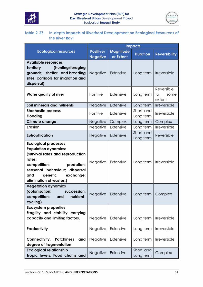
Strategic Development Plan (SDP) for
Ravi Riverfront Urban Development Project
Ecological Impact Study
Section - 2: OBSERVATIONS AND INTERPRETATIONS 61
Table 2-27: In-depth Impacts of Riverfront Development on Ecological Resources of
the River Ravi
Ecological resources
Impacts
Positive/
Negative
Magnitude
or Extent Duration Reversibility
Available resources
Territory (hunting/foraging
grounds; shelter and breeding
sites; corridors for migration and
dispersal)
Negative Extensive Long term Irreversible
Water quality of river Positive Extensive Long term
Reversible
to some
extent
Soil minerals and nutrients Negative Extensive Long term Irreversible
Stochastic process
Flooding Positive Extensive
Short and
Long term Irreversible
Climate change Negative Complex Long term Complex
Erosion Negative Extensive Long term Irreversible
Eutrophication Negative Extensive Short and
Long term Reversible
Ecological processes
Population dynamics:
(survival rates and reproduction
rates;
competition; predation;
seasonal behaviour; dispersal
and genetic exchange;
elimination of wastes.)
Negative Extensive Long term Irreversible
Vegetation dynamics
(colonisation; succession;
competition; and nutrient-
cycling)
Negative Extensive Long term Complex
Ecosystem properties
Fragility and stability carrying
capacity and limiting factors,
Productivity
Connectivity, Patchiness and
degree of fragmentation
Negative
Negative
Negative
Extensive
Extensive
Extensive
Long term
Long term
Long term
Irreversible
Irreversible
Irreversible
Ecological relationship
Tropic levels, Food chains and Negative Extensive
Short and
Long term Complex

Strategic Development Plan (SDP) for
Ravi Riverfront Urban Development Project
Ecological Impact Study
Section - 2: OBSERVATIONS AND INTERPRETATIONS 62
Ecological resources
Impacts
Positive/
Negative
Magnitude
or Extent Duration Reversibility
food webs, herbivore-plant
relationships, predator-prey
relationships, herbivore-
carnivore relationships,
adaptation and dynamism
Ecological role or function
Decomposer, primary producer,
consumers, parasite and
predator, keystone species.
Negative
Extensive
Long term
Irreversible
2.4 SECTION –4 MITIGATION MEASURES
The mitigation priorities for the project are avoidance or minimization,
restoration and compensation. The aims of providing mitigation measures are
to provide environmentally friendly options which will minimize unnecessary
habitat loss.
2.4.1 Impact avoiding/minimizing
First measure to reduce the impacts of construction and operation of the
project, are in form of avoiding and minimizing the impacts.
A. Avoiding dumping of dredged spoil in other ecological habitats
adjacent to the site: During construction of the project, the dredged
spoil will be created. It should be avoided to dump such spoil in closer
habitats. As dumping of this excess material will degrade other
habitats too.
B. Protection of other habitats with fences and barriers: During
construction phase, a fence should be used as a barrier to protect
forested area as well as agricultural land as much as possible. So that
such habitats and their wildlife remain undisturbed.
C. Minimization of barging disturbance to wildlife: Noise and disturbance
may increase while barging spoil and would have effects on birds and
other animals. Following mitigation measures may be adopted to
protect birds against excessive noise and disturbance:
• The construction workers on the barge should avoid making
sudden loud noises or disturbing birds.
• Barging of more spoil should be scheduled in the summer to
avoid the migratory period of birds in winter as far as possible.
A. The adoption of diligent and proper construction practices can

Strategic Development Plan (SDP) for
Ravi Riverfront Urban Development Project
Ecological Impact Study
Section - 2: OBSERVATIONS AND INTERPRETATIONS 63
mitigate the erosion near the riverbanks during excavation process,
thereby minimizing the threat of turbidity and toxicity to the fish stock.
Moreover, it is pertinent to prevent buildup of excessive bedload in
order to protect the fish habitats, in particular the spawning grounds.
The damage from the blast shocks can also be minimized by
constructing a temporary fencing/screen to ensure that the fish stock
remains out of range from the blast area. Similarly, the timing of the
explosives can also be adjusted for use during periods when fish
activity is likely to be minimum in the area, e.g. daylight hours, dry
season (Welcomme, 1985).
B. It is crucial to monitor the fauna habitat, feeding, nesting requirements
of birds and interaction with the community and ecosystem in general.
The monitoring activity helps in determining the areas of high sensitivity
and priority and in turn modify the development work to minimize the
detrimental impacts on the habitat and reproductive activity of
terrestrial animal species.
2.4.2 Restoration and Compensation
Secondly restoration and compensation are mitigation measures that can be
followed if impacts are to be minimized. Restoration can be important
measure in this project to value ecological resources of the area and
restoring the degraded habitats is the best option available. Whereas
Compensation in this project refers to reimbursement of loss or used habitat
in favorable condition.
a. Avoiding loss of existing forests: Almost 255 Acre land area of Shahdra,
Katar Bund, Anno Bhatti, Korotana and Shadanwali forests is expected
to be lost in the widening of the River channel. At the first place these
forests should be tried to be saved from being lost using some
engineering approach or re-design by creating islands. But in extreme
and unavoidable circumstances proper land and monetary
compensation shall be paid to the Forest Department for re-
establishment of these lost forest areas. It will take a much longer time
period for the mature forest stands to establish and start providing the
lost ecosystem services they are currently providing so doing this
should only be taken as a last resort.
b. Forest restoration with native species: As mentioned in Table 5 that still
1750 Acre of land area is available in the forests for plantation.
Moreover, during the construction phase of the project species in the
forested land may also be affected. There will be a need to restore
and augment the populations after the project completion to
enhance the biodiversity in the area and to provide more habitats for
other species. Such forest restoration should be carried out with native
Strategic Development Plan (SDP) for
Ravi Riverfront Urban Development Project
Ecological Impact Study
Section - 2: OBSERVATIONS AND INTERPRETATIONS 64
species, e.g. Dalbergia sissoo, Tamarix aphylla, Acacia nilotica,
Populus euphratica, Prosopis cineraria and Tamarix dioca etc. Almost
1750 Acre area in the current forests is still blank and is available for
plantations, on that 1,058,811 more trees can be established (12 ft x 6
ft density). This will enhance the site value and in part will provide
compensation for the lost habitat for the species.
c. Revegetation along the embankment slopes and along the river:
Plantation of grasses, sedges and other herbs on the outside
embankment slopes and their adjacent areas has a potential to
mitigate lost riparian grassland habitats. Planting on such bank slopes
would increase the value of habitat by providing vertical structural
diversity and will provide a compensation for the lost land-water
interface for the movement of reptile and amphibian species.
Establishment of extensive and continuous vegetation cover along the
embankments of the riverbanks is highly recommended. It is further
recommended that at least 50 m wide continuous green belt
comprising of shrubs and trees be established on both sides of the river.
A mixture of plant species with various life forms and heights should be
used to encourage development of a multi-level canopy which would
increase the habitat diversity and resource provision to the biological
diversity.
d. Creation of buffer zones along the main roads and railway tract: Buffer
belts along the main roads and railway tracts shall be created using
native tree species of the thorn forest community that has been lost
from this area due to land clearance for agriculture purposes i.e. P.
cineraria, Salvadora oleoides, T. aphylla and Capparis decidua. This
will not only help in the conservation of native species of wild flora and
fauna but will also reduce air and noise pollution created by vehicles.
A good compensation for the lost habitats can be creation of new
habitats at other sites.
e. Creation of grasscretes in the foreshore areas: The establishment of
grasscrete in the foreshore areas like viewpoints, parking lots and
walking tracts can be made with grasscrete using native grasses
(Plates 51B-52). “Foreshore is the part of a shore between the water
and cultivated or developed land.”
f. Island vegetation: Islands in the project area should be planted with
the shoreline vegetation which will be removed from the riverbanks.
This will help in compensating the lost vegetation of the riverbank and
restoring a new site with native trees.

Strategic Development Plan (SDP) for
Ravi Riverfront Urban Development Project
Ecological Impact Study
Section - 3: CONCLUSION AND RECOMMENDATIONS 65
SECTION - 3: CONCLUSION AND RECOMMENDATIONS
On the basis of results of the current study it is concluded that development
in this area will have less impacts on the ecological resources of the area if
the following recommendations will be considered during construction and
operation of the project:
1- River is an important place for the wildlife, aquatic life, and riparian
vegetation. It is important to conserve the river Ravi as a sustainable
support to flora and fauna of this area.
2- It is imperative to protect the river as a continuous wildlife corridor and
not a fragmented unsustainable corridor. The riverbank should be
constructed like that there should be option for its revegetation with
native grasses and sedges. A list of plants suitable for plantation at
riverbank is provided in appendix 3.
3- Forests are prime wildlife habitat within the project area, so it is highly
recommended that all of the forests should be retained. The project
shall be designed in such a way that all the forest areas are protected.
4- Habitats and species of conservation value should be protected. It is
crucial to monitor the fauna habitat, feeding and nesting
requirements and interaction with the community and ecosystem in
general. The monitoring activity allows the decision makers to
determine the areas of high sensitivity and priority and in turn modify
the development work to minimize the detrimental impacts on the
habitat and reproductive activity of species. Indian Soft-shell turtle are
vulnerable species of the site. It is important to conduct population
surveys for soft-shell turtle and chekered keelback snake and all the
other species that are listed in CITES or are protected under Schedule
III of Punjab Wildlife Act, and to identify their breeding populations
and nesting grounds to minimize the effects of this developmental
activity on the ecology of their habitat. Help in this regard can be
taken from Punjab Wildlife Department, species specialist groups of
IUCN and WWF-P.
5- It is suggested that ramps along the riverbanks shall be made at
appropriate distance and places to give access to wildlife.
6- Migratory route used by the birds to cross Pakistan is known as Green
route or Indus Flyway or International Bird Migratory route number 4.
Almost one million migratory birds visit Pakistan each year, majority of
them during winter season (Nov. to Feb.). Due to the construction and
development in the area, many migratory birds of the area will be
disturbed or maybe they leave to visit this site in future. It is therefore
important to avoid or reduce construction activities during that time

Strategic Development Plan (SDP) for
Ravi Riverfront Urban Development Project
Ecological Impact Study
Section - 3: CONCLUSION AND RECOMMENDATIONS 66
of the year in particular areas so as not to disturb their right-of-way.
Monitoring their behavior during construction will also be important.
Help in this regard can be taken from WWF-P and Wildlife Department.
A list of birds along with their migratory season is given in table 30
Table 3-1: Visiting season of the migratory birds found at the project site
No. Scientific names Common names Migration
season Months
1 Upupa epops Hoopoe Winter Oct-Feb
2 Vanellus indicus Red wattled
Lapwing Summer
Monsoon (May-
Oct)
3 Anas Platyrhynchos Mallard Winter Nov-Feb
4 Gallinula chloropus Common moorhen Winter Sept-May
5 Merops philippinus Blue tailed bee
eater Summer March-Sept
6 Actitis hypoleucos Common Sand
piper Winter Aug-Mar
7 Anas crecca Common teal Winter Nov-Mar
8 Gallinago gallinago Common snipe Winter Sep-Mar
9 Hirundo rustica Common swallow Winter Oct-Mar
10 Coturnix coturnix Common Quail Winter Sep-Mar
11 Egretta garzetta little egret Winter Oct-May
12 Hydrophasianus
chirurgus
white pheasant
jacana Summer Mar-Oct
13 Himantopus
himantopus Black winged stilt Winter Oct-Mar
7- Reducing pollution loads of the river by installing wastewater
treatment plants will definitely have a positive impact on the fish
species and other aquatic life but barrages and river channel diversion
for islands might affect them. Although in the project design there are
two fish ladders with each barrage for ensuring the movement of fishes
but to what extent these will be used by individual species is not clear.
Studies have shown difference in the behavior of fish species regarding
use of fish ladders. Moreover, there is a need to protect our native fish
species that are under threat and their population has already
suffered a considerable decline due to introduction of exotic species,
overexploitation and habitat degradation. Help in this regard can be
taken from Fisheries Department.
8- The surveys during this study have shown that the riparian forests are
affected by the factors like overgrazing, trespassing, trampling and
invasion of exotic species like Parthenium, mesquite and Lantana. If

Strategic Development Plan (SDP) for
Ravi Riverfront Urban Development Project
Ecological Impact Study
Section - 3: CONCLUSION AND RECOMMENDATIONS 67
properly restored these forests have a lot of potential to compensate
the loss of tree species elsewhere as a result of this development. It is
therefore suggested to conduct a detailed study on the current status
of these forests to propose management interventions for their
ecological restoration. Help in this regard can be taken from
Restoration Ecology Research Group of Sustainable Development
Study Centre, GC University Lahore.
9- Forest restoration should be carried-out to provide habitat to native
biological diversity and to ensure their conservation. Rehabilitation of
these forests to a healthier state will not only provide biological benefits
but will also provide social benefits. Guided trails for the tourists and
local residents can be made in the forests for nature experience like
bird watching etc. This will also increase the heuristic value of these
forests (value for education and research). Help in this regard can be
taken from Restoration Ecology Research Group of Sustainable
Development Study Centre, GC University Lahore and the Punjab
Forest Department.
10- It is strongly recommended that no metal or concrete roads shall pass
through the forest areas to avoid their fragmentation and isolation. This
will also act as a barrier for wildlife movement and will result in their
population decline because of strikes or reduced mobility. Noise
produced by this will also affect their behavior, feeding and nesting of
birds etc.
11- It was observed that agroforestry is widely practiced in some forests
especially Dahnna Bhaini and Korotana forests which should be
discontinued to keep forests in an intact state. Agriculture alters soil
properties due to ploughing, irrigation, use of fertilizers and pesticides
etc., that make them good for weed invasion and less suitable for
forest growth.
12- Buffer belts around roads and railway tracts shall be planted using
native tree species to extend wildlife habitat and to compensate tree
loss from other sites. It is highly recommended that some area in the
buffers shall be set aside for the establishment of once widespread
native Thorn Forest community comprising of Salvadora oleoides,
Prosopis cineraria, Tamarix aphylla and Capparis decidua trees. These
floodplain thorn forests have been totally exterminated from almost all
of their historic range mostly because of the clearance of land for
agricultural purposes. Recreation of a lost forest type will have a high
conservation value and will be a good compensation measure. This
restored Thorn Forest will not only provide habitat to native flora and
fauna but will also act as a demonstration site and a living classroom
for the students for their education and research. Help in this regard
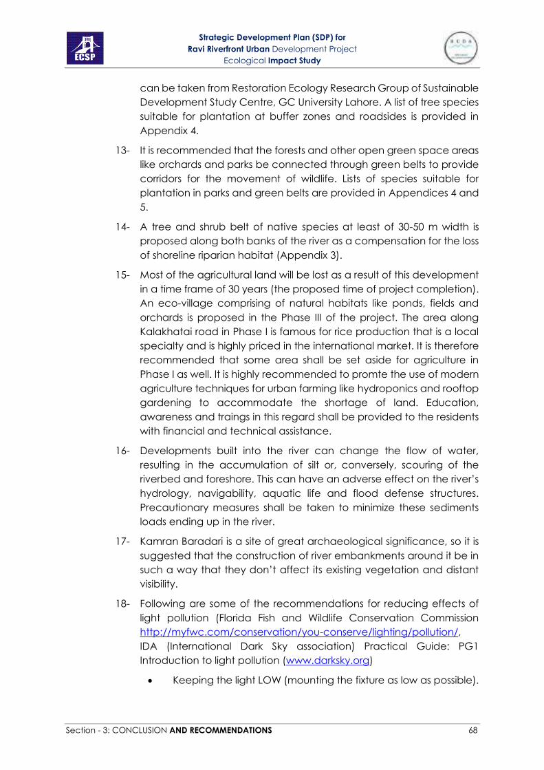
Strategic Development Plan (SDP) for
Ravi Riverfront Urban Development Project
Ecological Impact Study
Section - 3: CONCLUSION AND RECOMMENDATIONS 68
can be taken from Restoration Ecology Research Group of Sustainable
Development Study Centre, GC University Lahore. A list of tree species
suitable for plantation at buffer zones and roadsides is provided in
Appendix 4.
13- It is recommended that the forests and other open green space areas
like orchards and parks be connected through green belts to provide
corridors for the movement of wildlife. Lists of species suitable for
plantation in parks and green belts are provided in Appendices 4 and
5.
14- A tree and shrub belt of native species at least of 30-50 m width is
proposed along both banks of the river as a compensation for the loss
of shoreline riparian habitat (Appendix 3).
15- Most of the agricultural land will be lost as a result of this development
in a time frame of 30 years (the proposed time of project completion).
An eco-village comprising of natural habitats like ponds, fields and
orchards is proposed in the Phase III of the project. The area along
Kalakhatai road in Phase I is famous for rice production that is a local
specialty and is highly priced in the international market. It is therefore
recommended that some area shall be set aside for agriculture in
Phase I as well. It is highly recommended to promte the use of modern
agriculture techniques for urban farming like hydroponics and rooftop
gardening to accommodate the shortage of land. Education,
awareness and traings in this regard shall be provided to the residents
with financial and technical assistance.
16- Developments built into the river can change the flow of water,
resulting in the accumulation of silt or, conversely, scouring of the
riverbed and foreshore. This can have an adverse effect on the river’s
hydrology, navigability, aquatic life and flood defense structures.
Precautionary measures shall be taken to minimize these sediments
loads ending up in the river.
17- Kamran Baradari is a site of great archaeological significance, so it is
suggested that the construction of river embankments around it be in
such a way that they don’t affect its existing vegetation and distant
visibility.
18- Following are some of the recommendations for reducing effects of
light pollution (Florida Fish and Wildlife Conservation Commission
http://myfwc.com/conservation/you-conserve/lighting/pollution/,
IDA (International Dark Sky association) Practical Guide: PG1
Introduction to light pollution (www.darksky.org)
• Keeping the light LOW (mounting the fixture as low as possible).

Strategic Development Plan (SDP) for
Ravi Riverfront Urban Development Project
Ecological Impact Study
Section - 3: CONCLUSION AND RECOMMENDATIONS 69
• Lower the wattage of all outdoor lighting—both municipal and
private. Over lighting reduces the eye’s ability to see outside of
the lit area. In addition, excess light can produce glare, which
also reduces visibility. Selecting the correct lamp wattage
increases safety and reduces costs.
• Place motion sensors on essential outdoor lamps. Lighting on
demand trumps a manual switch or timer. Motion sensitive
switches light walkways when need.
• SHIELDED (fully shielding the light so bulbs and/or glowing lenses
are not visible) cuts down on the amount of glare and light
visible to the animals, so that there is less opportunity for them
to get trapped, repelled, or have their day/night patterns
altered.
Figure 3-1: Fixtures that enhance and reduce light pollution
• Keeping it LONG wavelength (ambers and reds) actually
makes the light that is visible seem dimmer to nocturnal animals
that primarily use rod vision. Some long wavelength light sources
such as low-pressure sodium lights and amber and red LEDs use
a fraction of the energy of their mercury halide, incandescent
and even fluorescent counterparts and cut down greenhouse
gas emissions.
• Closing curtains at night to keep indoor light in, especially in a
multi-storied building will prevent bird crashes
• Considering them as prime wildlife habitat in the urban area
lighting in the Forest areas should be avoided.
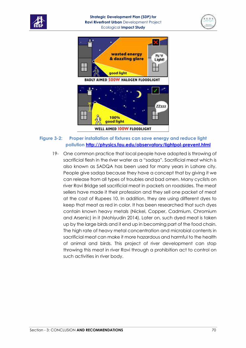
Strategic Development Plan (SDP) for
Ravi Riverfront Urban Development Project
Ecological Impact Study
Section - 3: CONCLUSION AND RECOMMENDATIONS 70
Figure 3-2: Proper installation of fixtures can save energy and reduce light
pollution http://physics.fau.edu/observatory/lightpol-prevent.html
19- One common practice that local people have adopted is throwing of
sacrificial flesh in the river water as a “sadqa”. Sacrificial meat which is
also known as SADQA has been used for many years in Lahore city.
People give sadqa because they have a concept that by giving it we
can release from all types of troubles and bad omen. Many cyclists on
river Ravi Bridge sell sacrificial meat in packets on roadsides. The meat
sellers have made it their profession and they sell one packet of meat
at the cost of Rupees 10. In addition, they are using different dyes to
keep that meat as red in color. It has been researched that such dyes
contain known heavy metals (Nickel, Copper, Cadmium, Chromium
and Arsenic) in it (Mohiyudin 2014). Later on, such dyed meat is taken
up by the large birds and it end up in becoming part of the food chain.
The high rate of heavy metal concentration and microbial contents in
sacrificial meat can make it more hazardous and harmful to the health
of animal and birds. This project of river development can stop
throwing this meat in river Ravi through a prohibition act to control on
such activities in river body.
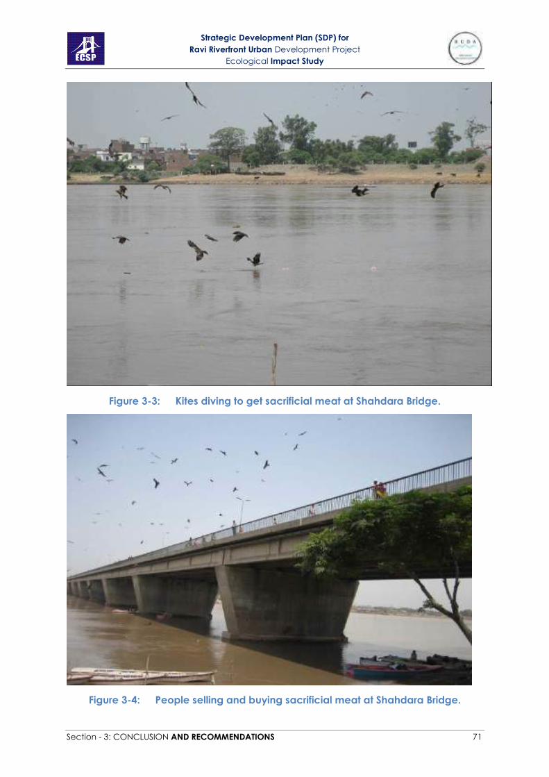
Strategic Development Plan (SDP) for
Ravi Riverfront Urban Development Project
Ecological Impact Study
Section - 3: CONCLUSION AND RECOMMENDATIONS 71
Figure 3-3: Kites diving to get sacrificial meat at Shahdara Bridge.
Figure 3-4: People selling and buying sacrificial meat at Shahdara Bridge.
Strategic Development Plan (SDP) for
Ravi Riverfront Urban Development Project
Ecological Impact Study
Section - 3: CONCLUSION AND RECOMMENDATIONS 72
20- To avoid bird collisions following measures can be taken
• Bird-safe glazing treatments should be included like fritting,
netting, permanent stencils, frosted glass, exterior screens,
physical grids placed on the exterior of glazing or UV patterns
visible to birds.
• Awareness campaigns for developers, architects, planners,
property owners, businesses, residents and youth groups should
be arranged.
• Interior plants should be moved from the window so as not to
be visible from the outside to the birds.
• Consider limiting nighttime building use by combining motion
operated light sensors with daytime cleaning services. This
combination will reduce light pollution and increase energy
conservation.
• Where interior lighting is used at night, window coverings should
be closed to block light transmission adequately.
• Consider seasonal migration needs. Unneeded interior and
exterior lighting should be turned off from dusk to dawn during
this period.

Strategic Development Plan (SDP) for
Ravi Riverfront Urban Development Project
Ecological Impact Study
Section - 3: CONCLUSION AND RECOMMENDATIONS 73
Figure 3-5A: Spotlight on building height and bird migration
(San Francisco Planning Department 2011)
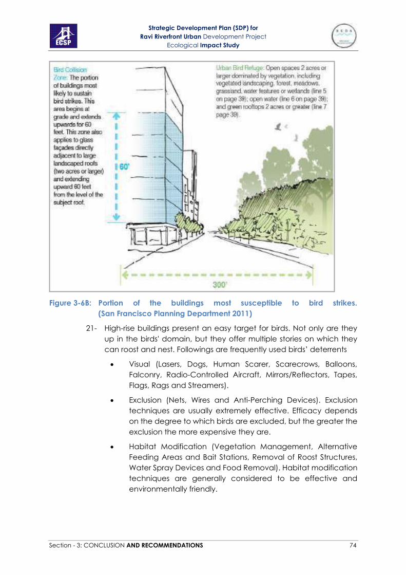
Strategic Development Plan (SDP) for
Ravi Riverfront Urban Development Project
Ecological Impact Study
Section - 3: CONCLUSION AND RECOMMENDATIONS 74
Figure 3-6B: Portion of the buildings most susceptible to bird strikes.
(San Francisco Planning Department 2011)
21- High-rise buildings present an easy target for birds. Not only are they
up in the birds' domain, but they offer multiple stories on which they
can roost and nest. Followings are frequently used birds’ deterrents
• Visual (Lasers, Dogs, Human Scarer, Scarecrows, Balloons,
Falconry, Radio-Controlled Aircraft, Mirrors/Reflectors, Tapes,
Flags, Rags and Streamers).
• Exclusion (Nets, Wires and Anti-Perching Devices). Exclusion
techniques are usually extremely effective. Efficacy depends
on the degree to which birds are excluded, but the greater the
exclusion the more expensive they are.
• Habitat Modification (Vegetation Management, Alternative
Feeding Areas and Bait Stations, Removal of Roost Structures,
Water Spray Devices and Food Removal). Habitat modification
techniques are generally considered to be effective and
environmentally friendly.
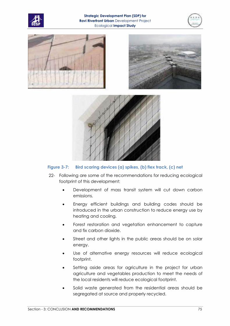
Strategic Development Plan (SDP) for
Ravi Riverfront Urban Development Project
Ecological Impact Study
Section - 3: CONCLUSION AND RECOMMENDATIONS 75
Figure 3-7: Bird scaring devices (a) spikes, (b) flex track, (c) net
22- Following are some of the recommendations for reducing ecological
footprint of this development:
• Development of mass transit system will cut down carbon
emissions.
• Energy efficient buildings and building codes should be
introduced in the urban construction to reduce energy use by
heating and cooling.
• Forest restoration and vegetation enhancement to capture
and fix carbon dioxide.
• Street and other lights in the public areas should be on solar
energy.
• Use of alternative energy resources will reduce ecological
footprint.
• Setting aside areas for agriculture in the project for urban
agriculture and vegetables production to meet the needs of
the local residents will reduce ecological footprint.
• Solid waste generated from the residential areas should be
segregated at source and properly recycled.

Strategic Development Plan (SDP) for
Ravi Riverfront Urban Development Project
Ecological Impact Study
Section - 3: CONCLUSION AND RECOMMENDATIONS 76
• Compositing of all the garden waste will be cut down synthetic
fertilizer use and help in reducing ecological footprint.
Strategic Development Plan (SDP) for
Ravi Riverfront Urban Development Project
Ecological Impact Study
Section - 3: CONCLUSION AND RECOMMENDATIONS 77
Literature Consulted
Acreman, M., & Dunbar, M.J. (2004). Defining environmental river flow requirements:
A review. Hydrology and Earth System science, 8(5), 861-867.
Akhtar M, Mahboob S, Sultana S, Sultana T, Alghanim KA, Ahmed Z (2014) Assessment
of Pesticide Residues in Flesh of Catla catla from Ravi River, Pakistan The
Scientific World Journal 2014
Alho, C. J. R. (2011). Environmental effects of hydropower reservoirs on wild mammals
and freshwater turtles in Amazonia: a review.
Barbarossa, V., Schmitt, R. J., Huijbregts, M. A., Zarfl, C., King, H., & Schipper, A. M.
(2020). Impacts of current and future large dams on the geographic range
connectivity of freshwater fish worldwide. Proceedings of the National
Academy of Sciences, 117(7), 3648-3655.
Benstead, J. P., March, J. G., Pringle, C. M., & Scatena, F. N. (1999). Effects of a low‐
head dam and water abstraction on migratory tropical stream
biota. Ecological Applications, 9(2), 656-668.
Bernacsek, G. M. (2001). Environmental issues, capacity and information base for
management of fisheries. Dams, Fish and Fisheries: Opportunities, Challenges
and Conflict Resolution, (419), 139.
Biggs, B.J.F., 2000. New Zealand periphyton guideline: detecting, monitoring and
managing enrichment of streams [online]. Wellington: Ministry for the
Environment.
Chen, C. (2011). A study on sustainable riverfront landscape design: On design
strategy based on ecological recovery and context protection. Master Thesis.
University of Florida, United States.
Ufdcimages.Uflib.Ufl.Edu/Uf/E0/04/38/69/00001/Chen_C.Pdf. Accessed on 9
September 2014.
CSIRO. (1991). the insects of Australia. A textbook for students and research workers.
New York, Cornell University Press, 1135.
Dynesius, M., & Nilsson, C. (1994). Fragmentation and flow regulation of river systems
in the northern third of the world. Science, 266(5186), 753-762.
ERC. (2010). A report on the surveying method of ecological impact study of the
environmental impact assessment of Hong Kong section of Guangzhou-
Shenzhen-Hong Kong Express Rail. Hong Kong: Eco-Education & Resources
Centre.http://www.legco.gov.hk/yr09-
10/english/panels/tp/tp_rdp/papers/tp_rdp0920cb1-2879-9-e.pdf. Accessed
on 8 September 2014.
Fox, R.L. (2013). Sinclair riverfront ecological enhancement project:
Recommendations – 2007. Iowa: Landscape Architecture + Planning.
http://ruthfoxlandarch.com/sinclair-site-investigation/. Accessed on 11

Strategic Development Plan (SDP) for
Ravi Riverfront Urban Development Project
Ecological Impact Study
Section - 3: CONCLUSION AND RECOMMENDATIONS 78
September 2014.
GISD. (2005). Global Invasive Species Database. Kenya: Global Invasive
Species Programme. http://www.issg.org/database. Accessed 6 September
2014.
Champion, H.G., Seth, S. K., & Khattak, G.M. (1965). Forest types of Pakistan.
Peshawar: Pakistan Forest Institute.
Gelb, Yigal; Nicole Delacretaz. 2009. Windows and Vegetation: Primary Factors in
Manhattan Bird Collisions Northeastern Naturalist. 16(3):455-470.
GOP (Government of Punjab). 2013. Forest Area. GIS Lab. of Dev. and Working Plan
Circle, Punjab Forest Department, Lahore.
Grimmett, R., Roberts, T. J., Inskipp, T., & Byers, C. (2008). Birds of Pakistan. A&C Black.
Hanson, A. (2012). Reconnecting to a forgotten river: An ecological solution. Bachelor
design Thesis, North Dakota State University, and Fargo, United States.
http://library.ndsu.edu/repository/handle/10365/20053. Accessed on 9
September 2014.
Heim, S. (2002). Ecological impact study. Connecticut: TRC Environmental
Corporation Windsor.
Www.middletownplanning.com/SumnerBrook_Ecological_Impact_St.
Accessed on 12 September 2014.
Hersh, B.F. (2012). The complexity of urban waterfront redevelopment. New York:
University Schack Institute of Real Estate
http://www.naiop.org/en/Research/Our-Research/Reports/The-Complexity-
of-Urban-Waterfront-Redevelopment.aspx
Hoch, P. (2011). Species/Flora of Pakistan. Missouri: Tropicos org. Missouri Botanical
Garden. http://www.tropicos.org/Project/Pakistan. Accessed on 4
September 2014.
IEEM. (2006). Guidelines for ecological impact assessment in the United Kingdom.
Hampshire: Institute of Ecology and Environmental Management.
http://www.cieem.net/data/files/Resource_Library/Technical_Guidance
pdf. Accessed on 12 September 2014.
Iqbal, M., Saleem, I., Ali, Z., Khan, M.A., & Akhtar, M. (2011). Bird ecology from the Ravi
River of Lahore: Habitat degraded. The Journal of Animal & Plant Sciences,
21(4), 817-821
Iqbal, M.Z. Malik, S.A., & Chaudhry, A.A. (2007). Birds of Lahore cantonment. Pakistan
Journal of Zoology, 39(4), 203-214.
Irving, D. B., & Modde, T. (2000). Home-range fidelity and use of historic habitat by
adult Colorado pikeminnow (Ptychocheilus lucius) in the White River,
Colorado and Utah. Western North American Naturalist, 16-25.

Strategic Development Plan (SDP) for
Ravi Riverfront Urban Development Project
Ecological Impact Study
Section - 3: CONCLUSION AND RECOMMENDATIONS 79
IUCN. (2014). The IUCN red list of threatened species. Version 2014.2. Cambridge:
International Union for Conservation of Nature and Natural Resources. http://
www.iucnredlist.org. Accessed on 5 September 2014.
J. Bishop, H. McKay, D. Parrott and J. Allan. 2003. Review of international research
literature regarding the effectiveness of auditory bird scaring techniques and
potential alternatives.
Kashyap, S.R. (1936). Lahore district flora. Lahore: University of the Punjab.
Nasir, E. and S.I. Ali. (1971-2005). Flora of Pakistan. Islamabad: Pakistan
Agriculture Research Centre.
Khalid, S., & Siddiqui, S. (2014). Weeds of Paksiatn: Cyperaceae. Pak. J. Weed Sci. Res.,
20(2): 233-263.
Khan A, Ali Z, Shelly S, Ahmad Z, Mirza M (2011) Aliens; a catastrophe for native
freshwater fish diversity in Pakistan Journal of Animals and Plants Sciences
21:435-440
Khan A, Shakir H, Khan M, Abid M, Mirza M (2008) Ichthyofaunal survey of some fresh
water reservoirs in Punjab J Anim Pl Sci 18:151
Khan MS (2004) Annotated checklist of amphibians and reptiles of Pakistan Asiatic
Herpetological Research 10:191-201
Khan MS (2010) Checklist of Amphibians of Pakistan Pakistan J Wildlife 1:37-42.
Klem, D. Jr. February, 2009. Avian Mortality At Windows: The Second Largest Human
Source of Bird Mortality on Earth. Proceedings of the Fourth International
Partners in Flight Conference: Tundra to Tropics. 244-251
Liao, W. L., Bhargava, D. S., & Das, J. (1988). Some effects of dams on
wildlife. Environmental Conservation, 15(1), 68-70.
Liermann, C.R., Nilsson, C., Robertson, J. & Ng, R.Y. (2012). Implications of dam
obstruction for global freshwater fishdiversity. BioScience 62: 539–548.
Longcore T, Rich C (2004) Ecological light pollution Frontiers in Ecology and the
Environment 2:191-198
Malik RN, Rauf S, Mohammad A, Ahad K (2011) Organochlorine residual
concentrations in cattle egret from the Punjab Province, Pakistan
Environmental monitoring and assessment 173:325-341
Mihov, S., & Hristov, I. (2011). River ecology. World Wide Fund.
http://awsassets.panda.org/downloads/riverecology_eng_bt13dec.pdf.
Assessed 8 September 2014.
Milunovic, M. (2007). The redevelopment of Belgrade’s riverfront: Developing
landscape design and planning solutions for ecological sustainability of
Danube riparian ecosystem. Master thesis. SUNY College of Environment
Science and Forestry, United States.

Strategic Development Plan (SDP) for
Ravi Riverfront Urban Development Project
Ecological Impact Study
Section - 3: CONCLUSION AND RECOMMENDATIONS 80
http://www.esf.edu/la/capstones/2008/Milunovic_Milica_08/Milunovic_prop
osal_08.pdf. Accessed on 10 September 2014.
Mohy-u-din N., Farooq A., Mehwish M. and Adnan S. A. 2014. Assessment of
contaminants in sacrificial meat sold at various locations in Lahore, Pakistan.
Int. J. Curr. Microbiol. App. Sci. 3(6): 292-303
Moza, U. (2014). River Ravi ecology and fishery. New Delhi: Indian Council of
Agricultural Research. http://www.icar.org.in/files/River_Ravi.pdf. Assessed
10 September 2014.
Newton, I. (2010). The migration ecology of birds. Elsevier.
Noreen, U. (2008). Illegal trade in freshwater turtle parts. Islamabad: Pakistan Wetland
Programme.
http://www.wwfpak.org/species/images/FreshwaterTurtles_publications/lleg
alTradeofFreshwaterTurtlesParts.pdf. Assessed 15 September 2014
Noureen, U. (2007). Freshwater turtles of Pakistan. Islamabad: Pakistan Wetland
Programme.
http://www.wwfpak.org/species/images/FreshwaterTurtles_publications/Fres
hwaterTurtlesofPakistan2-2007.pdf. Assessed 15 September 2014
NSTA. (2004). Protocol 5. Collecting aquatic invertebrates. Arlington: National Science
Teachers Association. http://www.scilinks.org/. Accessed on 9 September
2014.
Otto, B., McCormick, K., & Leccese, M. (2004). Ecological riverfront design: restoring
Rivers, connecting communities. Planning advisory service report number
518-519. Chicago: American Planning Association.
https://www.csu.edu/cerc/documents/EcologicalRiverfrontDesign.pdf
Accessed on 10 September 2014.
Parker, R.N. (1956). A forest flora for the Punjab with Hazara and Dehli. Lahore: Govt.
Printing Press.
Poff, N. L., & Schmidt, J. C. (2016). How dams can go with the flow. Science, 353(6304),
1099-1100.
Poff, N.L. & Zimmerman, J.K. (2010) Ecological responses toaltered flow regimes: a
literature review to inform the scienceand management of environmental
flows. Freshwater Biology 55:194–205.
Rafique, M., Khan, N.H. (2012). Distribution and status of significant freshwater fishes of
Pakistan Zoology Survey of Pakistan. 21, 90-95.
Rauf A, Javed M, Ubaidullah M (2009) Heavy metal levels in three major carps (Catla
catla, Labeo rohita and Cirrhina mrigala) from the river Ravi, Pakistan Kidney
2:4.43-40.92b
Strategic Development Plan (SDP) for
Ravi Riverfront Urban Development Project
Ecological Impact Study
Section - 3: CONCLUSION AND RECOMMENDATIONS 81
Reid, A. J., Carlson, A. K., Creed, I. F., Eliason, E. J., Gell, P. A., Johnson, P. T., ... & Cooke,
S. J. (2019). Emerging threats and persistent conservation challenges for
freshwater biodiversity. Biological Reviews, 94(3), 849-873.
Roberts, T. J. (2005a). Field guide to the large and medium-sized mammals of Pakistan.
Oxford University Press.
Roberts, T. J. (2005b). Field guide to the small mammals of Pakistan. Oxford Univeristy
Press.
Roberts, T.J. (1991). The birds of Pakistan, regional studies and non-passeriformes.
Oxford university press.
Roberts, T.J. (1992). The birds of Pakistan, passeriformes: Pittas to buntings. Oxford
university press.
Roberts, T.J. (1997). The mammals of Pakistan. Oxford university press. Revised edition
Roberts, T.J. (2001). The butterflies of Pakistan. Oxford university press.
Roberts, T.J., (2006). Field Guide to the Large and Medium-sized Mammals of Pakistan.
Oxford university press.
Roberts, T.J., (2006). Field Guide to the Small Mammals of Pakistan. Oxford university
press.
Sadia S.A., & Mirza, Z. B. (2011). Ecological and socioeconomic linkages of birds of river
riverine habitats. Pakistan Journal of Zoology, 43(1), 113-122.
Saeed, M., Khan, Z. D., & Ajaib, M. (2012). Some phytosociological studies of
chasmophytes and ediphytes of Lahore city. Pak. J. Bot., 44: 165-169.
San Francisco Planning Department. 2011. Standards for Bird-Safe Buildings. Draft
report prepared by San Francisco Planning Department, USA.
Shafiq, M.M. (2005). Wildlife acts & rules of Pakistan. Peshawar: Pakistan Institute of
Forest, ministry of Environment, Govt. of Pakistan.
www.falcons.com.pk/Wildlife_acts_and_rules.pdf. Accessed on 9 September
2014.
Shakir H, Qazi J (2013) “Impact of industrial and municipal discharges on growth
coefficient and condition factor of major carps from Lahore stretch of river
Ravi. Journal of Animal and Plant Sciences 23:167-173
Shakir H.A., & Qazi, J.I. (2013). Impact of industrial and municipal discharges on growth
coefficient and growth factor of major carps from Lahore stretch of River
Ravi. The Journal of Animal & Plant Sciences, 23(1), 167-173
Shakir HA, Shazadi K, Qazi JI, Hussain A. (2014). Planktonic diversity in gut contents of
Labeo rohita from Ravi, Pakistan reflecting urban loads on the river Biologia
(Pakistan) 60:87-92

Strategic Development Plan (SDP) for
Ravi Riverfront Urban Development Project
Ecological Impact Study
Section - 3: CONCLUSION AND RECOMMENDATIONS 82
Singh, A.P. (2011). Birds of the upper catchment of Ravi River, Chamba district,
Himachal Pradesh, India. Indian birds, 7(4): 97–103.
Syed JH, Malik RN, Li J, Chaemfa C, Zhang G, Jones KC (2014) Status, distribution and
ecological risk of organochlorines (OCs) in the surface sediments from the
Ravi River, Pakistan Science of the Total Environment 472:204-211
The Severn Barrage. (2007). the Severn Barrage Project. Accessed on 1 September,
2014.
http://www.foe.co.uk/sites/default/files/downloads/the_severn_barrage.pd
f
Triplehorn, C.A., Johnson, N.F. (2005). Borror and DeLong’s Introduction to the Study of
Insects, seventh ed. Thompson Books/Cole, Belmont, CA.
USAC. (2003). Peoria riverfront development, Illinois (ecosystem restoration), feasibility
study with integrated environmental assessment. Illinois: Rock Island District,
Corps of Engineers, Department of the Army.
http://sites.cityofvancouver.us/Report.pdf. Accessed on 12 September 2014.
Van Puijenbroek, P. J., Buijse, A. D., Kraak, M. H., & Verdonschot, P. F. (2019). Species
and river specific effects of river fragmentation on European anadromous fish
species. River Research and Applications, 35(1), 68-77.
WAPCOS. (2012). Technical analysis of EIA report of development of waterfront at
Mormugao port Goa. New Delhi: Centre for Science and Environment.
http://www.cseindia.org/userfiles/eia_review.pdf. Accessed on 10
September 2014.
Welcomme, R. L. (1985). River fisheries. FAO Technical Paper No. 262. Food and
Agriculture Organisation: Geneva.
Wheater, C.P., Bell, J.R., & Cook, P.A. (2011). Practical field ecology: A project guide.
Hoboken: Wiley & Sons Ltd. Publication.
Zeng, Q., Lu, C., Li, G., Guo, Z. B., Wen, L., & Lei, G. C. (2017). Impact of a dam on
wintering waterbirds’ habitat use. Environmental Conservation, 45(4), 307-
314.
APPENDICES

Strategic Development Plan (SDP) for
Ravi Riverfront Urban Development Project
Ecological Impact Study
Section - 3: CONCLUSION AND RECOMMENDATIONS 68
Appendix-1: Appendices of CITES

Strategic Development Plan (SDP) for
Ravi Riverfront Urban Development Project
Ecological Impact Study
Section - 3: CONCLUSION AND RECOMMENDATIONS 69
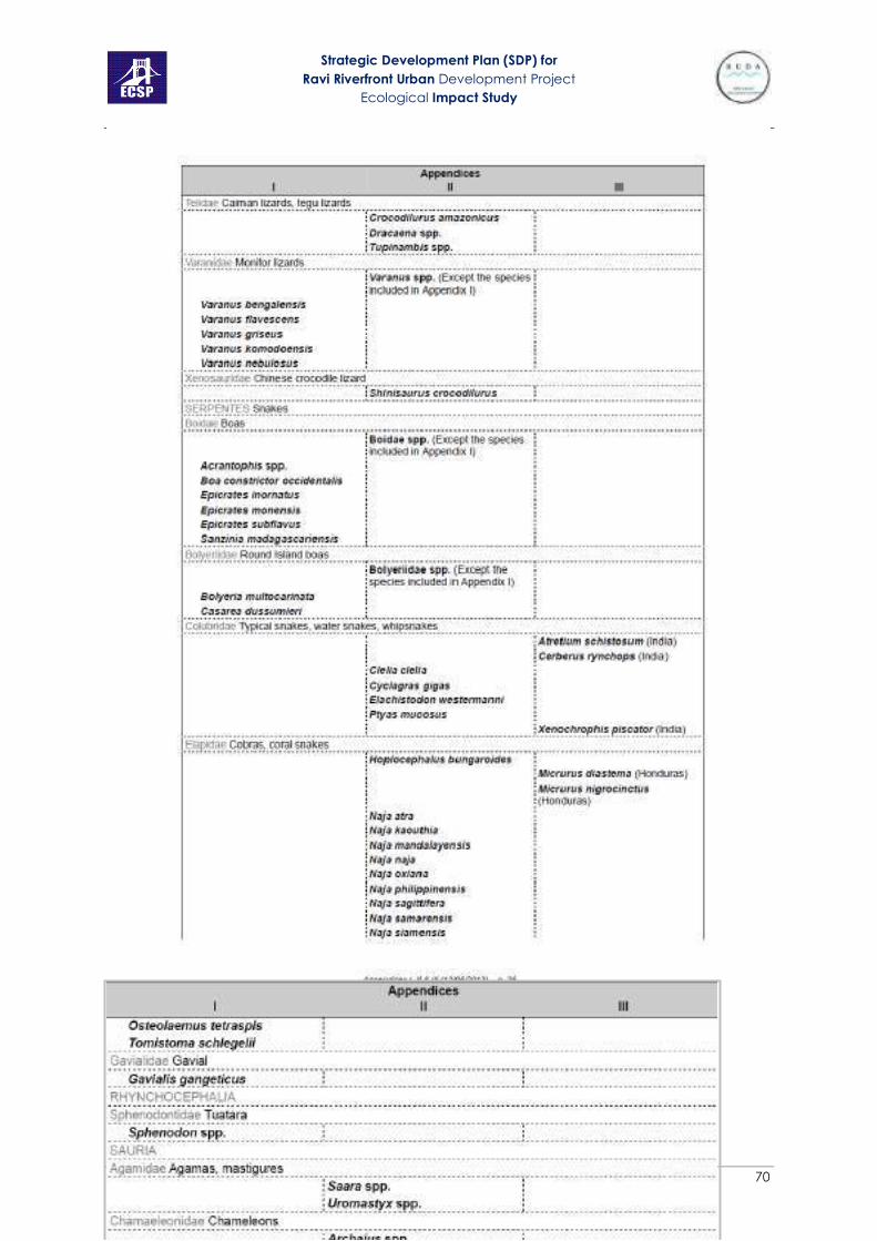
Strategic Development Plan (SDP) for
Ravi Riverfront Urban Development Project
Ecological Impact Study
Section - 3: CONCLUSION AND RECOMMENDATIONS 70

Strategic Development Plan (SDP) for
Ravi Riverfront Urban Development Project
Ecological Impact Study
Section - 3: CONCLUSION AND RECOMMENDATIONS 71
Appendix-2: Punjab Wildlife Act (amendments) 2007

Strategic Development Plan (SDP) for
Ravi Riverfront Urban Development Project
Ecological Impact Study
Section - 3: CONCLUSION AND RECOMMENDATIONS 72

Strategic Development Plan (SDP) for
Ravi Riverfront Urban Development Project
Ecological Impact Study
Section - 3: CONCLUSION AND RECOMMENDATIONS 73
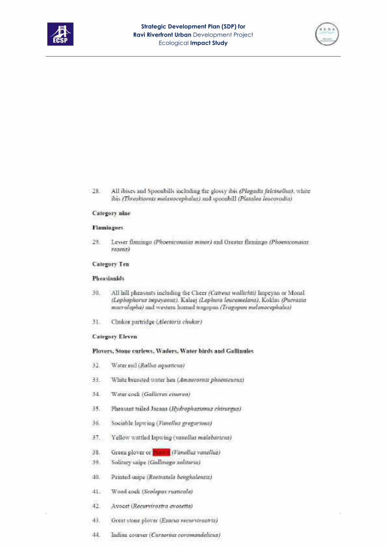
Strategic Development Plan (SDP) for
Ravi Riverfront Urban Development Project
Ecological Impact Study
Section - 3: CONCLUSION AND RECOMMENDATIONS 74

Strategic Development Plan (SDP) for
Ravi Riverfront Urban Development Project
Ecological Impact Study
Section - 3: CONCLUSION AND RECOMMENDATIONS 75

Strategic Development Plan (SDP) for
Ravi Riverfront Urban Development Project
Ecological Impact Study
Section - 3: CONCLUSION AND RECOMMENDATIONS 76
Appendix 3: List of plant species recommended to be planted on riverbank
Plant Type Local Name Family Height Flowering Time
Trees
Acacia modesta Phulai Fabaceae Medium April – May
Acacia nilotica Egyptian Thorn Mimosaceae 10-12m June – July
Bauhinia alba Sufaid Kachnar Fabaceae 8-12m March - April
Cassia fistula Amaltas Fabaceae 12-15m May - June
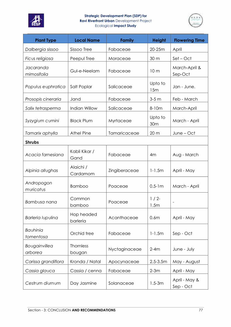
Strategic Development Plan (SDP) for
Ravi Riverfront Urban Development Project
Ecological Impact Study
Section - 3: CONCLUSION AND RECOMMENDATIONS 77
Plant Type Local Name Family Height Flowering Time
Dalbergia sissoo Sissoo Tree Fabaceae 20-25m April
Ficus religiosa Peepul Tree Moraceae 30 m Set – Oct
Jacaranda
mimosifolia Gul-e-Neelam Fabaceae 10 m
March-April &
Sep-Oct
Populus euphratica Salt Poplar Salicaceae Upto to
15m Jan - June.
Prosopis cineraria Jand Fabaceae 3-5 m Feb - March
Salix tetrasperma Indian Willow Salicaceae 8-10m March-April
Syzygium cumini Black Plum Myrtaceae Upto to
30m March - April
Tamarix aphylla Athel Pine Tamaricaceae 20 m June – Oct
Shrubs
Acacia farnesiana Kabli Kikar /
Gand Fabaceae 4m Aug - March
Alpinia allughas Alaichi /
Cardamom Zingiberaceae 1-1.5m April - May
Andropogon
muricatus Bamboo Poaceae 0.5-1m March - April
Bambusa nana Common
bamboo Poaceae
1 / 2-
1.5m -
Barleria lupulina Hop headed
barleria Acanthaceae 0.6m April - May
Bauhinia
tomentosa Orchid tree Fabaceae 1-1.5m Sep - Oct
Bougainvillea
arborea
Thornless
bougan Nyctaginaceae 2-4m June - July
Carissa grandiflora Kronda / Natal Apocynaceae 2.5-3.5m May - August
Cassia glauca Cassia / cenna Fabaceae 2-3m April - May
Cestrum diurnum Day Jasmine Solanaceae 1.5-3m April - May &
Sep - Oct

Strategic Development Plan (SDP) for
Ravi Riverfront Urban Development Project
Ecological Impact Study
Section - 3: CONCLUSION AND RECOMMENDATIONS 78
Plant Type Local Name Family Height Flowering Time
Cestrum
nocturnum Night Jasmine Solanaceae 1.5-3m
April - May &
Sep - Oct
Codiaeum
veriegatum Croton Euphorbiaceae 2-3m -
Duranta repens Pigeon berry Verbenaceae 1-4m May - Oct
Eranthemum
nervosum Neelum Acanthaceae 1-2m April-May
Euphorbia
cotinifolia Lal jhari Euphorbiaceae 1-5m Nov - April
Hamelia patens Jhumka /
Bunday Rubiacaee 2-4m
Throughout the
year
Hibiscus rosa-
sinensis Shoe flower Malvaceae 2-3m
Throughout the
year
Jasminum
grandiflora
Yasmeen /
Chambeli Oleaceae 3-5m Nov - Feb
Jasminum humile Pili chambali Oleaceae 2-3m Feb - March
Jasminum sambac Motia Oleaceae 2-4m April - Sep
Jatropha integrima Jatropha Euphorbiaceae 2-3m March-April
Juniperus prostrate Juniper Pinaceae 2-3m -
Lagerostoemia
lancasteri Gul-e-fanoos Lythraceae 1-3m May - Sep
Lawsonia inermis Heena Lythraceae 2-3m May - June
Murraya exotica Murva Rotaceae Upto 3m Many times a
year
Nerium oleander Oleander Apocynaceae 2–6 m May - June
Nyctanthes arbor-
tristis Har Singhar Oleaceae 2-4m Oct -Nov
Punica granatum Anar Punicaceae 3-4m April - May &
Sep - Oct
Russelia
sarmentosa Fountain bush Scrophulariaceae 1-2m
Most part of the
year

Strategic Development Plan (SDP) for
Ravi Riverfront Urban Development Project
Ecological Impact Study
Section - 3: CONCLUSION AND RECOMMENDATIONS 79
Plant Type Local Name Family Height Flowering Time
Schinus
terebinthilolius Kali mirch Anacardiaceae 3-4m March - April
Tamarix dioica salt cedar Tamaricaceae 1-18m -
Tecomella
undulate Lahura Bignoniaceae 3-5m Feb - April
Thevetia peruviana Pili kaner Apocynaceae 3-4m April - May /
Year round
Thuja orientalis More Pankh Pinaceae 2-3m No flower
Herbs
Agave Americana Century Plant Asparagaceae Upto 9m June - July
Anemone sp. Windflower Ranunculaceae 0.2m June - Aug.
Aquilegia sp. Columbine Ranunculaceae 0.5m Feb - May
Dahlia sp. Dahlia Asteraceae 0.3m Dec - June
Freesia sp. Freesia Iridaceae 0.3m March-April
Gazania sp. Treasure Flower Asteraceae 0.2m Feb - June
Pansy sp. Pansy Violaceae 0.2m Jan - May
Pettunia sp. Petunia Solanaceae 0.3m Dec - March
Ranunculus sp. Buttercup Ranunculaceae 0.4m Feb - May
Solanum nigrum Black
Nightshade Solanaceae 0.15-0.6
Throughout the
year
Grasses & Sedges for river embankment slopes
Brachiaria reptans Creeping Panic
Grass Gramineae 0.1-0.5m
Throughout the
year
Carex fedia ness. Carex Cyperaceae 0.25-
0.6m April - May
Cyperus iria Rice Flat Sedge Cyperaceae 0.08m-
0.6m
Throughout the
year
Cyperus rotundus Nut-Grass Cyperaceae 0.3-0.4 Throughout the
year
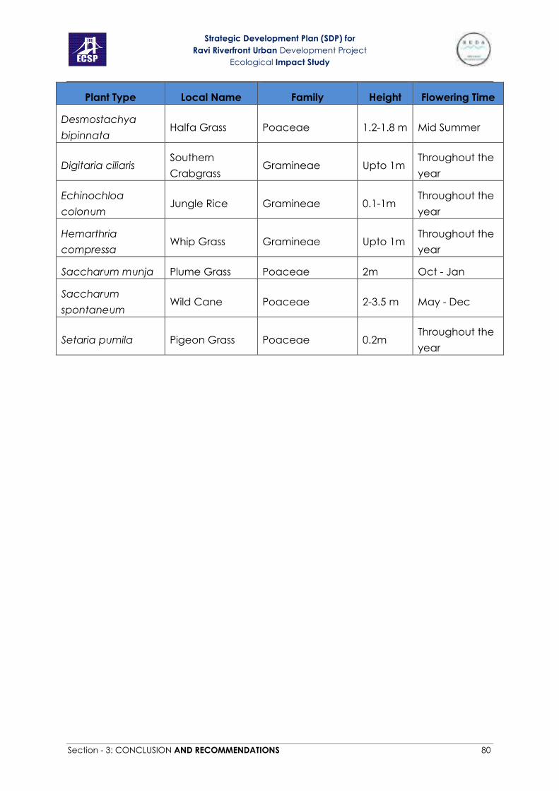
Strategic Development Plan (SDP) for
Ravi Riverfront Urban Development Project
Ecological Impact Study
Section - 3: CONCLUSION AND RECOMMENDATIONS 80
Plant Type Local Name Family Height Flowering Time
Desmostachya
bipinnata Halfa Grass Poaceae 1.2-1.8 m Mid Summer
Digitaria ciliaris Southern
Crabgrass Gramineae Upto 1m
Throughout the
year
Echinochloa
colonum Jungle Rice Gramineae 0.1-1m
Throughout the
year
Hemarthria
compressa Whip Grass Gramineae Upto 1m
Throughout the
year
Saccharum munja Plume Grass Poaceae 2m Oct - Jan
Saccharum
spontaneum Wild Cane Poaceae 2-3.5 m May - Dec
Setaria pumila Pigeon Grass Poaceae 0.2m Throughout the
year
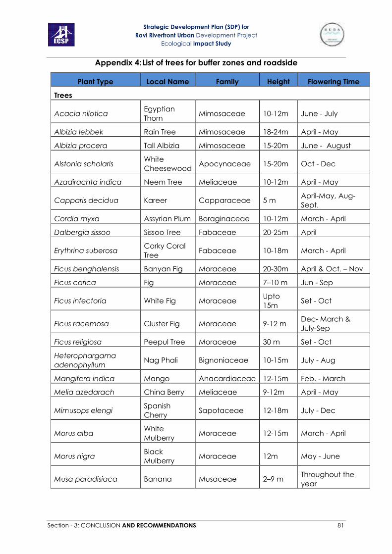
Strategic Development Plan (SDP) for
Ravi Riverfront Urban Development Project
Ecological Impact Study
Section - 3: CONCLUSION AND RECOMMENDATIONS 81
Appendix 4: List of trees for buffer zones and roadside
Plant Type Local Name Family Height Flowering Time
Trees
Acacia nilotica Egyptian
Thorn Mimosaceae 10-12m June - July
Albizia lebbek Rain Tree Mimosaceae 18-24m April - May
Albizia procera Tall Albizia Mimosaceae 15-20m June - August
Alstonia scholaris White
Cheesewood Apocynaceae 15-20m Oct - Dec
Azadirachta indica Neem Tree Meliaceae 10-12m April - May
Capparis decidua Kareer Capparaceae 5 m April-May, Aug-
Sept.
Cordia myxa Assyrian Plum Boraginaceae 10-12m March - April
Dalbergia sissoo Sissoo Tree Fabaceae 20-25m April
Erythrina suberosa Corky Coral
Tree Fabaceae 10-18m March - April
Ficus benghalensis Banyan Fig Moraceae 20-30m April & Oct. – Nov
Ficus carica Fig Moraceae 7–10 m Jun - Sep
Ficus infectoria White Fig Moraceae Upto
15m Set - Oct
Ficus racemosa Cluster Fig Moraceae 9-12 m Dec- March &
July-Sep
Ficus religiosa Peepul Tree Moraceae 30 m Set - Oct
Heterophargama
adenophyllum Nag Phali Bignoniaceae 10-15m July - Aug
Mangifera indica Mango Anacardiaceae 12-15m Feb. - March
Melia azedarach China Berry Meliaceae 9-12m April - May
Mimusops elengi Spanish
Cherry Sapotaceae 12-18m July - Dec
Morus alba White
Mulberry Moraceae 12-15m March - April
Morus nigra Black
Mulberry Moraceae 12m May - June
Musa paradisiaca Banana Musaceae 2–9 m Throughout the
year

Strategic Development Plan (SDP) for
Ravi Riverfront Urban Development Project
Ecological Impact Study
Section - 3: CONCLUSION AND RECOMMENDATIONS 82
Plant Type Local Name Family Height Flowering Time
Parkinsonia aculeate Cambron Fabaceae 7-10m March - April &
Sep - Oct
Phoenix dactylifera Date Palm Arecaceae 30 m Feb to March
Phoenix sylvestris Silver date
palm Arecaceae 4-15m June - July
Platanus orientalis Chinar Platanaceae Upto
25m March - May
Polyalthia longifolia Ashok Annonaceae 20-25m Feb - April
Populus euphratica Salt Poplar Salicaceae Upto
15m Jan - June.
Prosopis cineraria Jand Fabaceae 3-5 m Feb - March
Psidium guajava Guava Myrtaceae 6m April- May
Salix tetrasperma Indian Willow Salicaceae 8-10m March-April
Salvadora oleoides Vann Salvadoraceae 6m March-April
Syzygium cumini Black Plum Myrtaceae Upto
30m March - April
Tamarix aphylla Athel Pine Tamaricaceae 20 m June - Oct
Terminalia arjuna Arjun Tree Combretaceae 20-30m March - May
Ziziphus jujuba Chinese
Date Rhamnaceae 8-10m June - July

Strategic Development Plan (SDP) for
Ravi Riverfront Urban Development Project
Ecological Impact Study
Section - 3: CONCLUSION AND RECOMMENDATIONS 83
Appendix 5: List of Palms, Gymnosperms, shrubs and ferns for Parks and
Gardens
Plant Type Local Name Family Height Reproduction
Time
Palms
Bismarkia nobilis Bismarck palm Palmae 25m Mid spring
Borassus flabalifer Sugar palm Palmae 30m Feb - April
Butia capitata Jelly Palm Palmae Upto
6m June - July
Caryota urens Wine palm Palmae Upto
12m -
Chamaedorea
elegans Parlour Palm Palmae
0.1-
0.3m Mid Spring
Chamaerops humilis Fan Palm Palmae 2-5m April-May
Cocos nucifera Coconut Palm Palmae Upto
30m -
Dypsis lutescens Golden
cane palm Palmae 6-12m July - August
Livistona australis Slender palm Palmae Upto
25m April - May
Livistona chinensis Chinese Fan
Palm Palmae 13m -
Nannorrhops
ritchieana Mazari Palm Palmae 1-2m -
Neodypsis decaryl Triangle Palm Palmae 15m -
Phoenix canariensis Date palm Palmae 10-12m Jan
Phoenix dactylifera Date Palm Palmae 30 m Feb - March
Phoenix sylvestris Silver Date
Palm Arecaceae 4-15m June - July
Phoenix roebelenii Miniature Date
Palm Palmae 2-3m -
Phoenix rupicola Cliff Date Palm Palmae 8m -
Phoenix raclinata Wild date palm Palmae 7.5-15m Feb
Ravenea rivularis Majesty Palm Palmae 12m -
Rhapis excels Lady Palm Palmae 3m Jan

Strategic Development Plan (SDP) for
Ravi Riverfront Urban Development Project
Ecological Impact Study
Section - 3: CONCLUSION AND RECOMMENDATIONS 84
Plant Type Local Name Family Height Reproduction
Time
Rhapis humilis Slender Lady
Palm Palmae 3-4m -
Roystonea regia Cuban royal
palm Palmae 20-30m Jun - July
Sabal maxicana Texas Palmetto Palmae 9-12m April - May
Washingtonia filifera California Fan
Palm Palmae 9m Feb - March
Wodyetia bifurcata Foxtail Palm Palmae 6-9m
Gymnosperms
Araucaria
araucana
Monkey Puzzle
Tree
Araucariacea
e 40m Feb - March
Araucaria
cunnninghamii Hoop Pine
Araucariacea
e 60m -
Araucaria
heterophylla
Norfolk Island
Pine
Araucariacea
e 20-30m -
Cedrus deodara Deodar Pinaceae 40-50m Aug - Sep
Cupressus arizonica Arizona Cypress Cupressacea
e 15-25m -
Cupressus funebris Cypress Cupressacea
e 20-35m Feb
Cupressus
sempervirens Italian Cypress
Cupressacea
e 18m -
Cycas circinalis Queen Sago Cycadaceae Upto
4m -
Cycas revoluta Kungi Palm Cycadaceae 3m -
Ephedra ciliata Joint-pine Ephedraceae 0.2m -
Ginkgo biloba Maidenhair
Tree Ginkgoaceae 20-35 April
Juniperus
horizontalis
Creeping
Juniper Pinaceae
0.1-
0.3m June
Pinus halepensis Aleppo Pine Pinaceae 15-25m March - April
Pinus roxburghii Chir pine Pinaceae 30-50m Jan - April
Podocarpus
macrophyllus Kusamaki
Podocarpac
eae 20m -
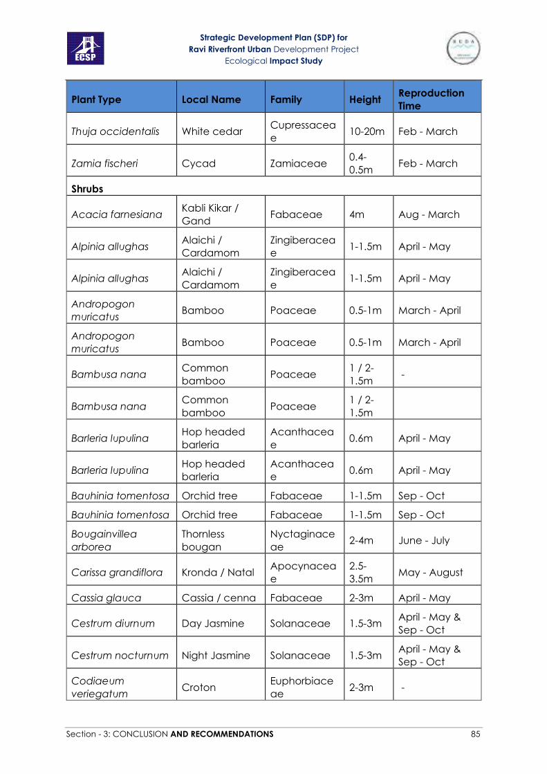
Strategic Development Plan (SDP) for
Ravi Riverfront Urban Development Project
Ecological Impact Study
Section - 3: CONCLUSION AND RECOMMENDATIONS 85
Plant Type Local Name Family Height Reproduction
Time
Thuja occidentalis White cedar Cupressacea
e 10-20m Feb - March
Zamia fischeri Cycad Zamiaceae 0.4-
0.5m Feb - March
Shrubs
Acacia farnesiana Kabli Kikar /
Gand Fabaceae 4m Aug - March
Alpinia allughas Alaichi /
Cardamom
Zingiberacea
e 1-1.5m April - May
Alpinia allughas Alaichi /
Cardamom
Zingiberacea
e 1-1.5m April - May
Andropogon
muricatus Bamboo Poaceae 0.5-1m March - April
Andropogon
muricatus Bamboo Poaceae 0.5-1m March - April
Bambusa nana Common
bamboo Poaceae
1 / 2-
1.5m -
Bambusa nana Common
bamboo Poaceae
1 / 2-
1.5m
Barleria lupulina Hop headed
barleria
Acanthacea
e 0.6m April - May
Barleria lupulina Hop headed
barleria
Acanthacea
e 0.6m April - May
Bauhinia tomentosa Orchid tree Fabaceae 1-1.5m Sep - Oct
Bauhinia tomentosa Orchid tree Fabaceae 1-1.5m Sep - Oct
Bougainvillea
arborea
Thornless
bougan
Nyctaginace
ae 2-4m June - July
Carissa grandiflora Kronda / Natal Apocynacea
e
2.5-
3.5m May - August
Cassia glauca Cassia / cenna Fabaceae 2-3m April - May
Cestrum diurnum Day Jasmine Solanaceae 1.5-3m April - May &
Sep - Oct
Cestrum nocturnum Night Jasmine Solanaceae 1.5-3m April - May &
Sep - Oct
Codiaeum
veriegatum Croton
Euphorbiace
ae 2-3m -
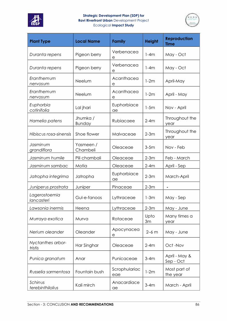
Strategic Development Plan (SDP) for
Ravi Riverfront Urban Development Project
Ecological Impact Study
Section - 3: CONCLUSION AND RECOMMENDATIONS 86
Plant Type Local Name Family Height Reproduction
Time
Duranta repens Pigeon berry Verbenacea
e 1-4m May - Oct
Duranta repens Pigeon berry Verbenacea
e 1-4m May - Oct
Eranthemum
nervosum Neelum
Acanthacea
e 1-2m April-May
Eranthemum
nervosum Neelum
Acanthacea
e 1-2m April - May
Euphorbia
cotinifolia Lal jhari
Euphorbiace
ae 1-5m Nov - April
Hamelia patens Jhumka /
Bunday Rubiacaee 2-4m
Throughout the
year
Hibiscus rosa-sinensis Shoe flower Malvaceae 2-3m Throughout the
year
Jasminum
grandiflora
Yasmeen /
Chambeli Oleaceae 3-5m Nov - Feb
Jasminum humile Pili chambali Oleaceae 2-3m Feb - March
Jasminum sambac Motia Oleaceae 2-4m April - Sep
Jatropha integrima Jatropha Euphorbiace
ae 2-3m March-April
Juniperus prostrata Juniper Pinaceae 2-3m -
Lagerostoemia
lancasteri Gul-e-fanoos Lythraceae 1-3m May - Sep
Lawsonia inermis Heena Lythraceae 2-3m May - June
Murraya exotica Murva Rotaceae Upto
3m
Many times a
year
Nerium oleander Oleander Apocynacea
e 2–6 m May - June
Nyctanthes arbor-
tristis Har Singhar Oleaceae 2-4m Oct -Nov
Punica granatum Anar Punicaceae 3-4m April - May &
Sep - Oct
Russelia sarmentosa Fountain bush Scrophulariac
eae 1-2m
Most part of
the year
Schinus
terebinthilolius Kali mirch
Anacardiace
ae 3-4m March - April

Strategic Development Plan (SDP) for
Ravi Riverfront Urban Development Project
Ecological Impact Study
Section - 3: CONCLUSION AND RECOMMENDATIONS 87
Plant Type Local Name Family Height Reproduction
Time
Tamarix dioica salt cedar Tamaricacea
e 1-18m -
Tecomella undulata Lahura Bignoniacea
e 3-5m Feb - April
Thevetia peruviana Pili kaner Apocynacea
e 3-4m
April - May /
Year round
Thuja orientalis More Pankh Pinaceae 2-3m No flower
Herbs
Pettunia sp. Petunia Solanaceae 0.3m Dec - March
Pansy sp. Pansy Violaceae 0.2m Jan - May
Gazania sp. Treasure Flower Asteraceae 0.2m Feb - June
Dahlia sp. Dahlia Asteraceae 0.3m Dec - June
Freesia sp. Freesia Iridaceae 0.3m March - April
Ranunculus sp. Buttercup Ranunculace
ae 0.4m Feb - May
Grasses & Sedges
Arundo don Nara Poaceae Upto
1.5m Nov - Feb
Cynodon dactylon Khabble Grass Poaceae 0.2m Throughout the
year
Cyperus nutans - Cyperaceae 0.5m Oct - Nov
Ferns
Adiantum
raddianum - Pteridaceae
0.1-
0.3m -
Adiantum venustum - Pteridaceae 0.2-0.3 -
Cyrtomium
falcatum -
Dryopteridac
eae 0.5m -
Dryopteris ramosa - Dryopteridac
eae - -
Marsilea quadrifolia - Marsileaceae 0.19m -
Onychium
japonicum - Pteridaceae
0.4-
0.6m -
Pteris vitata - Pteridaceae Upto
1m -

Strategic Development Plan (SDP) for
Ravi Riverfront Urban Development Project
Ecological Impact Study
Section - 3: CONCLUSION AND RECOMMENDATIONS 88

Strategic Development Plan (SDP) for
Ravi Riverfront Urban Development Project
Ecological Impact Study
Section - 3: CONCLUSION AND RECOMMENDATIONS 87
Appendix 6: Map of Anno Bhatti Forest

Strategic Development Plan (SDP) for
Ravi Riverfront Urban Development Project
Ecological Impact Study
Section - 3: CONCLUSION AND RECOMMENDATIONS 88
Appendix 7: Map of Shahdara Reserve Forest

Strategic Development Plan (SDP) for
Ravi Riverfront Urban Development Project
Ecological Impact Study
Section - 3: CONCLUSION AND RECOMMENDATIONS 89
Appendix 8: Map of Jhok, Korotana and Sadhanwali Forests
Recommended