l l l l l l l l l l l l l l l l l l l
H. FERDERBER GEOPHYSICS LTD ~-~-.
MANN 010
REPORT ON THE
AIRBORNE GEOPHYSICAL SURVEY
ON THE PROPERTY OF
SKEAD HOLDING LTD.
MANN TOWNSHIP, ONTARIO
BY i'
O/; )iW
H. l-'KRDKRRKR GEOPHYSICS LTD.
January, ]988 Va] d "Or, Quol.ioc
G.N. HenrikBen, B.Se, Goo] oqj st.

l l l l l l l l l l l l l l l l l l l
H. FERDERBER GEOPHYSICS LID rmrr-
REPORT ON THE
AIRBORNE GEOPHYSICAL SURVEY
ON THK PROPERTY OF
SKEAD HOLDING l,TD.
MANN TOWNSHIP, ONTARIO
INTRODUCTION
On December 33 to December 34, 3987 a n a irborne geophysical survey was carried out on the property of Skead Ho3ding Ltd. in Mann Township, Ontario. Magnetic and VLF-e3ectromagnetic data was collected by the airborne division of H. Ferderber
Geophysics Ltd. The survey was f 3 own from base at Ne33ie Lake- Jroquois Fa]3 s, Ontario. A total of 33.22 mi3es of data was co3 3 ected.
The magnetic survey provides information which he3ps define underlying geological structures and identifies any potential
economic concentrations from magnetic variations in accessory magnetic minerals. The VI,F-e3 ectromagneti c survey outlines conductive zones which may represent, shear zones and/or
metallic sulphide deposits containing gold mineralization.
3.0CATTON AND ACCESS
The Skead Holding Ltd. property is comprised of 6 claims in
Mann Township, Porcupine Mining Division, Ontario. The claims
cover approximately 96 hectares in the northeast corner of the township, are registered with the Ontario Mining Recorder's Office in Timmins and are 3isted be3ow.
1111111111111111111
— i.-.,.. ——— .. —— ...... ,...^™.......™.. ...H..™.,-........., . ^^-.-..-,,,.,,., —. — .™,,., . , — ...,,., .^^....^, — ̂̂̂ .... — MHM .... ——— .^ —— —————— ̂ H. FERDERBER GEOPHYSICS LTD - ——— -- ,
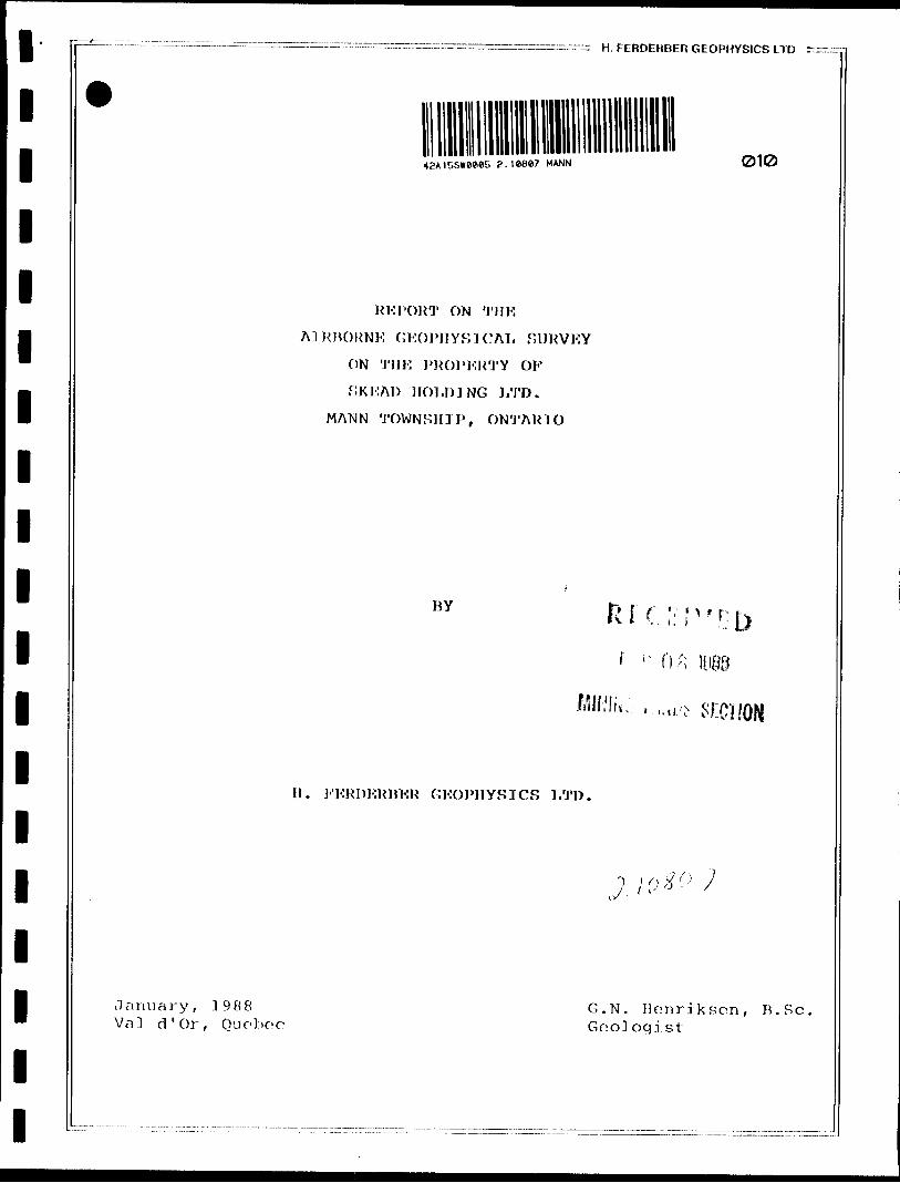
9Claim List
P 918936
918937
918938
918939
918940
918941
The property is located approximately 21.7 km (13 miles) southof the town of Cochrane, 26.7 km (16 miles) northwest of the
town of Iroquois Palls and 10 km (6 miles) west of the villageof Potter.
Access to the property is easily obtained from the village ofPotter which lies along Highway 11 between Cochrane andIroquois Falls. By tciking a secondary road due west from
Potter for about five and a quarter miles, continuing westward
at all junctions, a southwest bend in the road is reached. Thecentral part of the eastern boundary of the property lies aboutone quarter mile further west of the bend. The road continues
westward, traversing the property.
A small lake lies in the northeast corner of the property. Theproperty appears to be vegetated by deciduous trees in thenorth and coniferous trees in the south. Topographic relief islow and the terrain is relative dry.
'
i
r
!

J
111111111111111111
—— 'A —— . ——— ———
9
The
Pot
obi
— —— .-.... ——— ., — ———— ——— I — rr--r —— — — " —— -.:- —— — — — — -- ————————— H. FERDERtJI:R UEOPHYblCS III* —— A"
— *3 ^
Canadian National Railway line passes by the village ofter. Supplies, services and qualified manpower can beained in the Cochrane- Jroquoi s Fall-Timmins area.
GKOLOGY
The
Gr e
TheMap
be
to
The
met
property lies in the northwestern part of Abitibienstone Belt in the Superior Province of Canadian Shield.Ontario Department of Mines Geological Compilation Series2205, Timmi ns-Ki rkland Lake Sheet indicates the property to
underlain by metamorphosed ultramafic rocks and intermediatemafic metavolcanic rocks.
northern two thirds is shown as being underlain byamorphosed peri doti te-duni te-pyroxeni te-serpentinite . The
serpentinite may be composed of ultramafic flow rocks. Thesouthern third of the property is thought to be unerlain bymet.
The
amorphosed mafic flows and pyroclastic rocks.
contact between the rnetavolcani cs and metamorphosedultramafics trends northwest and appears to coincide with thelinear zone defined by the change in vegetation from deciduoustrees in the north part of the property and coniferous trees inthe south part of the property.
l l l l l l l l l l l l l l l l l l l
———. H. FERDERBER GEOPHYSICS LTD
-4-
A Ni-Cu occurrence lies about one mile west-northwest of the northwest corner of t lie property, along strike of the metamorphosed ultramafic rocks. About three and one half miles west of the northern part of the property lies a Ni-Cu-Pd occurrence which appears to be along strike of the geology of the claim group.
INSTKUMENTAT]ON AND SURVEY .METHODS
The survey was completed using a 1972 Cessna 172, fixed-wing aircraft, call letters CF-EWK, owned and operated by H. Ferderber Geophysics Ltd. The pilot and navigator/operator were Y. Saucier and M. Caron, respectively, of Val d'Or. Geophysical sensors were mounted in modified wing tips. The geophysical, navigation and data aquisition systems are described below.
Ma g netometer
The magnetometer used was a GEM Systems GSM-11, high sensitivity airborne proton (Overhauser) magnetometer. The instrument continuously measures the Earth's magnetic field at a 0.01 gamma sensitivity for l reading per second or 0.05 gamma to 10 readings per second at a 0.1 gamma absolute accuracy. The analog output i s on 3 channels, from l to 10,000 gammas full scale.
^ H. FERDERBER GEOPHYSICS LTD -:
— 5 —
yi.F-KM System
A Her?, Tot.em 2A VLF-KM System was used. To measure the change an the total field and jn the vertical quadrature fjeld on two frequencies simultaneously, with an accuracy of l?,. The primary transmitting station of Cutler Maine, (NAA) frequency 24.0 KHz was employed in survey.
Radar A11 i me t c^r
The ground clearance was measured with a King 10/10 A radar altimeter. The survey was flown at a mean clearance of 300 feet with the altimeter producing an accuracy of 51 (15 feet) at this altit ut e.
Tracking Camera an d Vi djso ̂ Ce ntre
A RCA TC-200 colour video camera and Galaxy 200 video centre was used to record the flight path on standard VHS type video tapes. Manual fiducials were indicated on the picture frames for reference with the digital printout. Flight path recovery was aided using a Panasonic Colour Video Monitor-S1300 and Video Cassette Recorder AG-2500.
l
1111111111111111111
9
Data
A Pi
-6-
Aguif.it i on System
codas Group Inc. PDAS 1100 data aquisition system featuringseven analog inputs with two frequency inputs and externali nt e
u n i t
aquiVI,}-1 -
quat
the
di sk
prof
The
rfacing was used. A Termiflex Corp. ST/32 Keyboard controland Sharp Corp. LCD display unit are connected to the data
sition system. At present this system stores the altimeter1 inphase, VLF-1 quadrature, VLF-2 inphase, VLF-2rature, magnetic field (coarse), magnetic field (fine), andfourth difference (noise), and fiducials on 3.5 inch floppydrive. The data is then printed out in digital and
ile form.
survey was conducted on north-south lines at anaircraft altitude of 300 feet. The lines were Flown ats pa c
hour
ings of 100 meters at a speed of approximately 90 miles perNavigation was visual using airphoto mosaics, at a scale
of one inch to 1320 feet, manual fiducials and the flight pathrecovery system as references.
DATA PRESENTATION
Flight lines, fiducial points and geophysical responses werereproduced from the topographic maps on maps at a scale of onei nch
clai
to 1320 feet (15,840). The outline of the claim group andm map are shown on each sheet.
L. ™. ~.—- - ~-~
l l l l l l l l l l l l l l l l l l l
~^^^:^^—:^^^^~^^^:~ H . FERDERBER GEOPHYSICS LTD zzr
-7-
The aeromagnetic data was corrected for diurnal variations by using a base line as reference. The data was then reduced to a base level of 58,000 gammas, contoured at ]00, 500 and ]000 gamma intervals and presented on Map MG-1 ,
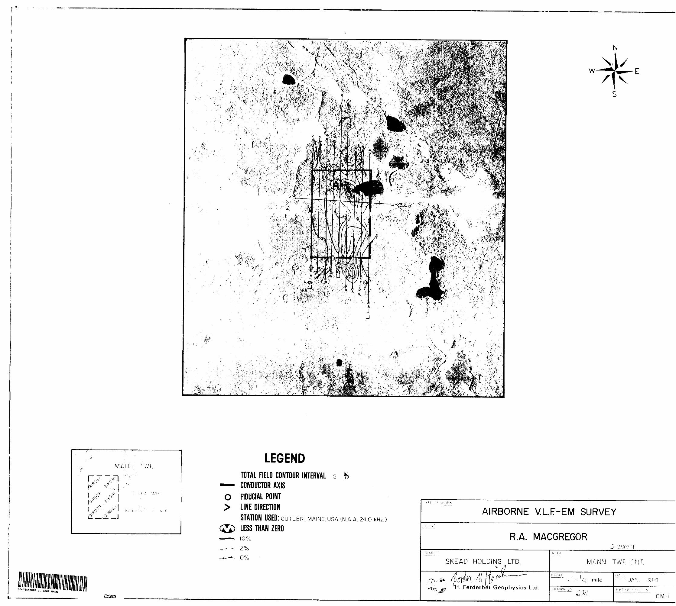
A base value was determined for the VLF-KM data and the change in the total field strength as a percentage of the base value was calculated. The values were plotted on map EM-1. The positive values were contoured at intervals of 2%. The conductor axes were determined and labelled A, B, C, etc. No priority was attached to the labelling system.
N'J'KRPRI-iTATJON
Magnetic Survey Map MG -l
The survey outlined two distinct northwest trending magnetic anomalous zones traversing the property. A magnetic high anomalous zone located in the northern half of the property has a steep magnetic gradient, magnetic values in excess of 4000 gammas above background and overlies rocks indicated as being metamorphosed ultramafics. A magnetic low anomalous zone on the southern half of the property has a shallow magnetic gradient and overlies rocks indicated as being intermediate to mafic metavol cani cs. The contact between the two rock units has a northwest trend and traverses the central part of the property.

1111111111111111111
— 8 —
9
VLF-elect romaqnet d c Survey Map EM-1
Conduct jvc '/.one A is a short, north-northwest tconductor located an the northeast part of the
FERDERBtR GEOPHYSICS 1.1D -~ ~y
rending
property. Tt] 3 es along the south shoulder of a magnet j c high anomalous zonecross cutting the magnetic contours at an oblique anglecioverlies probable met amorphosed ultramafic rocks. Conductor"A" may represent a structural break possibly a
CONCLUSIONS
shear zone.
The airborne VLF-el ect roinagneti c and magnetic surveys weresuccessful in outlining possible shear zones and helping definethe underlying geology of the Skead Holding LtdMann Township, Ontario. Rocks of high magnetic
. property insusceptabi lity
trending northwest underly the north half of the property andare probably metamorphosed ultramafics. The Nione mile west -northwest of the property, lies athe metamorphosed ultramafic rocks. Rocks of 1susceptabi li ty underly the southern half of thethought to be intermediate to mafic metavolcanibetween the metamorphosed ultramafic rocks and
-Cu occurrence,long strike of
ow magnetic -property are
cs. The contactthe intermediate
to mafic metavolcani c rocks trends west-northwest and traversesthe central part of the property.

l l l l l l l l l l l l l l l l l l l
H rFRDERBER GEOPHYSICS LTD r."-:
-9-
Conductivo xone A outlined in the northeast part of the property cippears to represent a bedrock conductor "A" possibly a shear 7.one wHhin the metamorphosed ultramafic rocks.
RKCOMMKNOAI 1 ] ONS
Further work is warranted on the property especially in the areas of the above mentioned conductor and the assumed position of the geologic contact determined by the magnetic data.
An exploration program of ground geophysics should be undertaken. A combined gradient/total field magnetic survey and a horizontal loop-electromagnetic survey should be performed. Geophysical anomalies should then be tested by diamond drilling.
Respectfully submitted,
H. FKRDKRBF.R GEOPHYSICS LTD.
G.N. Henri ksen, B.Se.
Geologi st

iviiiii^u y ol " Northern Development ?.'Vi M inos
KeporroT vvortc
Onlnrjo(Geophysical, Geological, * Geochemical and Expenditures)
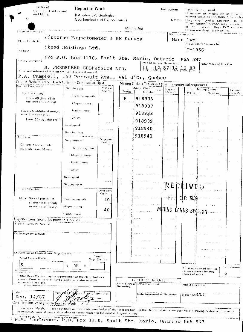
^ - C'.'o ^ { i., .l ypc oi
Claim Holder(s)Airborne Magnetometer fi EM Survey
Address
2.10807 MANN
J. Mann,Twp.Prospector's Liccnc
..—.—..- JT-19S6
900
e No.
Skead Holdinge Ltd. ^ ^ ,___
_......O/O..P.O....BOX 1110*. Semlt Ste. Marie, Ontario P6A 5N7mpany Date of Survey (from ft t ol lotSurvey Company
..-. ~.-. H. FERDERBER GEOPHYSICS LTD. . , ,Name and Address of Author (of Geo-1 echnical report)
R.A. Campbell, 169 Perrault Ave. , Val d'Or, Quebec
al Miles of line Cut
Credits Requested per Each Claim i n Columns a t rightSpecial Provisions
For first survey:
Enter 4 0 d ays. (This includes line cutting)
For each additional survey: using the same grid:
Enter 20 days (for each)
Geophysical
- Electromagnetic
- Magnetometer
- Radiometric
- Other
Geological
Days per Claim
Man Days
Complete reverse sidf tVM"" [ ) 8 and enter total(s) here
l J 1 M i M r\miiti
Geophysical
omagnetic
Airborne Credits
Note: Special provisionscredits do not apply to Airborne Surveys.
* Radiometric
- Other
Geological
Geochemical
Electromagnetic
Magnetometer
Days per Claim
Days per Claim
40
Type of Work Performci Tc l1 isPerformed on CIBim(s) . *^^-.DEC 15 1987
Calculation of Expenditure Days Credits
Total ExpendituresTotal
Days Credits
InstructionsTotal Days Credits may be apportioned at the claim holder's choice. Enter number of days credits per claim selected in columns at right.
DateDec, 14/87
d HnfQtr o r Agq^fl-ISignaturc)^^7^
jsyCertification Verifying Report of Work
Mining Claims Traversed (List in numerical sequence)Mining Claim
Prefix
^p
.V; ':-,
.
Number
918936 ^.918937 . ,.918930..-.. 918939 ^ 918940918941 __
——— .. —
, - ~ . ———— — . —————
—— . —— : — '..:
Expend. Days Cr.
ON
__ i ___
— Ln
— — — .-
.j —
ARAS
R
Mining ClaimPrefix Nunibcr
C' Of OL C
ort-
ff- H ?
: c t
.x .. i j
RI
IGtCAl. SURVEY
'GF
T* fCK^{
.---.— ----
. — . — ——— ... ..
E CO R D
E xpcru' , Days Ci
1
....... |
--— - -
ED
....,Total number of mining claims covered by this report of work.
For Office Use OnlyTotal Days Cr Recorded
i Appi
Mining Recor
sel^orth in iff is true.
l hereby certify that l have a personal and intimate knowledge of the facts or witnessed same during and/or after its completion and the annexed repo
the Report of Work annexed hereto, having performed the work
V'PW'TBox 1110, Sault Ste. Marie, Ontario P6A 5N7Cor t i (Ml by
1362(85/12)
Ontario
Ministry ofNorthern Developmentand Mines
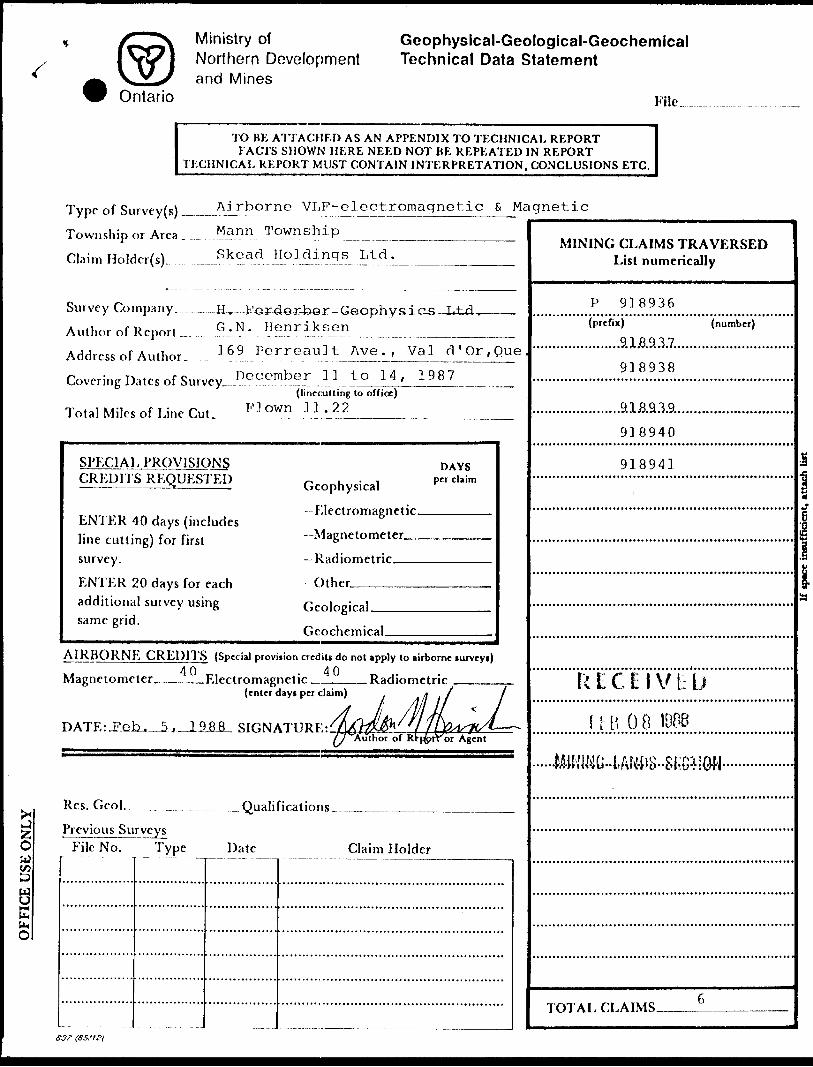
Geophysical-Geologlcal-Geochemical Technical Data Statement
File.
TO BE ATTACHED AS AN APPENDIX TO TECHNICAL REPORTFACTS SHOWN HERE NEED NOT BE REPEATED IN REPORT
TECHNICAL REPORT MUST CONTAIN INTERPRETATION, CONCLUSIONS ETC.
"Z.
O
Type of Survey{s) ^
To wu sli ip or Area .
Claim Holder(s).
Airborne VLF-elect.romagnetic St Magnetic
Mann Township
Skead Holdings Ltd.
Survey Company. H, Author of Report .
Address of Author.
G.N. Henriksen169 Perreault Ave., Val d'Or,Que
Covering Dates of Survey December 11 to 14, 1987(linfcutting to office)
Total Miles of Line Cut. ^ PLC)wn Jll^. _____ ,. ̂ .^
SPECIAL PROVISIONS CREDITS REQUESTED
ENTER 40 days (includes line cutting) for first survey.
ENTER 20 days for each additional survey using same grid.
Geophysical
Electromagnetic.—Magnetometer^-
—Radiometric———Other—.———.
DAYS per claim
Geological.
Geochemical.
AIRBORNE CREDITS (Special provision credits do not apply to airborne lurveyi)40 40 Magnetometer_____Electromagnetic _____ Radiometric
(enter days per claim)
SIGNATURE:Author of Rtpforror Agent
Res. Gcol. .— Qualifications.
File No. Type Date Claim Holder
MINING CLAIMS TRAVERSED List numerically
P 918936(prefix)
.........9.1.8.9.3.7..
918938
(number)
.........9.1&9.3.9..918940
91894]
k t C E l V D bf l B O B 11):
.a
iI
TOTAL CLAIMS.
S37 (35,'tei

SELF POTENTIAL
Instrument—.— .-.- . .-.- _ _—__ _________________.——— Range.
Survey Method_ . .—. ...... .-.—-...—- -_.....___.._.-———-—————————.-——--———
Corrections made__ ____-——.—--
Instrument—..—..-..-.———.— —..-... -—— __-^.—-^—-.————————-——-—————--.---—
Values measured — _ — --.—._ ._-________________________________
Energy windows (levels)^ —— - ...^...._—____________________________
Height of instrument— _^ _——_ ___.______________Background Count.Size of detector——. _. ——._.———-—-———^-————-——-—-—-—--————-———.^———--——-
Ovcrburden - _...,. ... . ^ ._ . ._.,__-——.————--.—.—.——-———————.——.—-.—.(type, depth — include outcrop map)
OTHERS (SlilSMlC, DRILL WELL LOGGING ETC.)Type of survey___ __ __ .______________
Instrument— ___________ -^^———.^———.——.
Accuracy__._________-—-^—-—^——-—-———.——.
Parameters measured_________——.——.—-—-——.—
Additional information (for understanding results).
Type of survty(s)_____^LF-EM. and Magnetometer
Instrument(s) _______Unrx l^±.em-2A and GEM GSM-11(specify for each type of survey)
Accuracy^.________^ a nd 0 ' ] Cfammas(specify for each type of survey)
Aircraft used___—_^-Cessna_172, fixpd wing aircraft (CF-EWK)
Sensoraltitucle ___ ___- 3 QD_
Navigation and flight path recovery method- Visual navigation on airphoto mosaic manual
___—.--..—_—,.____—,_______fiducial points and RCA TC-200 Colour Video
Aircraft altitude________1QO f en t:_______' ________Line Sparing 100 metp.r.q_____
Miles flown over total area_.J.l^-22____________________Over claims only____6 f 75 miles
"'••"y"' Hcpoit of Woiki Jotlhcih [Hivelopmunlarid Miru s (Gtuipliysica 1 , Geological,
COCK heniical and E xpondituies)
11 is 11 ne t lot t s: I 'li'.r.r l y pi* f x pt mt,H nil ml H* i of mining cUnms d ;jvri VM cxcffds space on this f orm, a tttirh n Ir.t
Note: - Only d.'iys cir()its c a leu In t fd in i IK "E xponditurcs" sfclion rnny J)f i -nit-n-i in ihf "F xprind. Days Cr." (^H Mining Act
\ j ic n1 ;,ni vry (s) '] Oivns up o
Airborne Magnetometer fc EM Survey MannCI. mn lloffli.i Is)
f.kead Holdings Ltd..\il.ln-.s
c/o P .O. Box 1 110, Sault Ste. Marie, Ontario P(Su'vi'v Company Dntc ol Survey (from Hi o )
H. FERDERBER GEOPHYSICS LTD. Wv wk2 | ?. 7 |i.4v \)v!,mie HIM! Addi e-, f. c f Author (of Gut) 1 ec hnrral r e p or 1 rR. A. Campbell, 169 Perrault Ave. , Val d'Or, Quebec
i A inn
Twp.f'f osper to
T-19!
5A 5N*
r's Licence No.
'6
7Total Miles ol line Cul
1Credits Rc(|ii(.Med pci f.ach Cl;iini in Columns at ii()ht Mining Claims Tiavcised (l ist in iHimnical sequence)
Foi Ins! sin voy:
E mn *10 C)RV!. (T his lin liiffns tine c jtt ing)
1 m {':u h ,"i(l(lition ;il survey: UMMT] t hr soiTif tjr i :l:
f ill ci ?0 (l,iys ifor {'Sell)
'.1;in (J.iys
rttu j rntcr 1ot;i!(s) KM p
Ail 1 KH ne Ci cents
Note: SpiH-i.'il pio 1 . isions rii'tiils do ncl ;ipply to Aiilioine SiMveys.
Goophysirnl
f lee 1 1 o nmgiiet ic
Mjfjnc-t onn-ioi
Hadin-nclur
- Other
G o c 1 1 ( i q i c ;i 1
Geochemit nl
Geophyr.it T!
E h'( tiOMUipneiic
- M ; t y M e l o m e 1 1? t
- O the'
Gcologiral
Gooc homic a!
T U'Ct' omnpnct ic
radiometric
[).'iy; per Claim
Day*, ppi
Days per Claim
40
40-
t xpendituios (excludes powei shipping)y,,,, oi We, t, iviioMi.iid
f'riioirnecl on Clairn(s)
Cali-ul (-i! ion of E xpcntl 1 ure O.'iys Crorlils Total Ininl f xpeiHlituies Days Credits
fs 2] - B * -Jrislt uctions
T 01 nt Days Cf edits may tip apportioned al the claim holder's rhone. fnifti ninnlx;!? of days rt edits p**r rinirn so octiKl m tolu nil)!; al i ight.
S ^[ "''"ite j neroim-iLKJcj^Jfi or AfK^r^Siquaturo) Dec. 14/87 \ f^^^^^——
Cci lificntion Venfyirci FU'fiort of Woik ^J
Mining Claim Pi efix Number
P J 91 8 9 36 ;918937 918938 918939 918940 9.18941....
j " "
\
i .. -,... ... ..- - . . . .
' 1
Y.:.:::.:"::' ''i ..........M
. -.-. .
f. K|K'II(J.Days Cr.
R Ei-i t- 1
NING i
"X
C
Aft
For Office Use Onlylotnl D.-iysCi. Date Recoicled Flecorded
Date Atiproved as Becorr ed
rvPrefix
.
.
a i9ai DS SF;{
ining CUiirn Number
- -
fj
I'M
f x,,, .ml
Total nurnhcr of mining J claims covered by this /- j report of work. " j
Mining Recorder
Branch Director
\ i ter eh y ret (if y thai 1 hriyf? a pc* son;)| and inlini;itc k 1 10 wl edge of t ho facts set forth in the Hepor t of Work annexed hereto, having performed the work m witnessed s/'tmt' d:; i ing fi 1 1 ci 'o i nl lei i Is '.oinplftior i a "d the iinnexeri f epm t is true.- ' ,, l( , - ,-,.,'t r (^t,-.| Addii-.n ol IVrson PPI tifyinri . , '
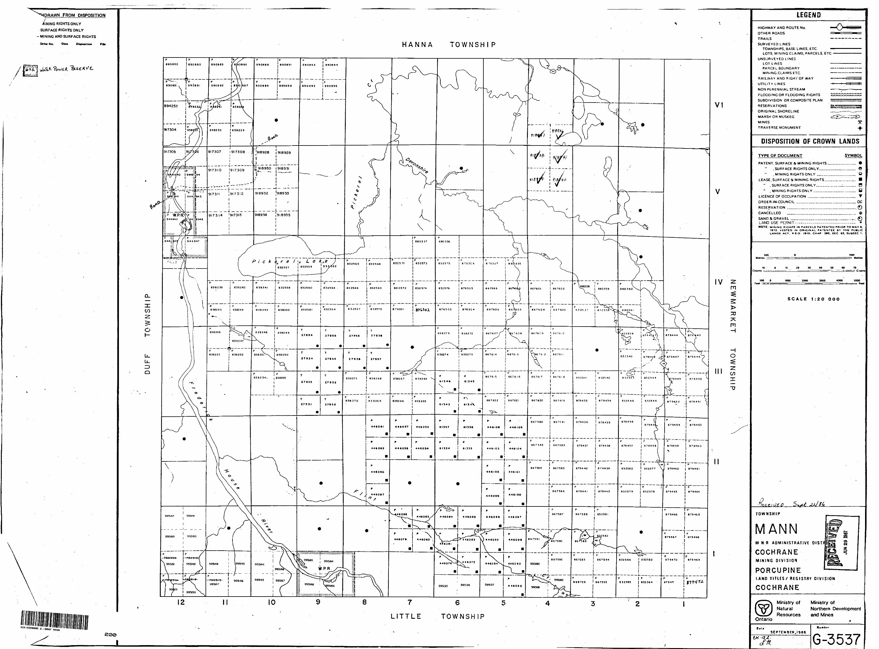
FROM DISPOSITION
/INING RIGHTS ONLY
SURFACE RIGHTS ONLY
- MINING AND SURFACE RIGHTS
Ordw No. Oat* Deposition Fa*
1/H/iiti
MANN
200
HANNA OWNSHI P
m
m-i
H O
COx"D
12
LITTLE TOWNSHIP
LEGENDHIGHWAY AND ROUTE No.
OTHER ROADS
TRAILS
SURVEYED LINESTOWNSHIPS. BASE LINES. ETC.LOTS. MINING CLAIMS. PARCELS, ETC
UNSURVEYED LINESLOT LINESPAHCEL BOUNDARYMINING CLAIMS ETC.
RAILWAY AND RIGHT OF WAY
UTILITY LINES
NON PfcHENNlAL STREAM
FLOODING OR FLOODING RIGHTS '
SUBDIVISION OR COMPOSITE PLAN
RESERVATIONS
ORIGINALSHORELINE
MARSH OR MUSKEG
MINES
TRAVERSE MONUMENT
DISPOSITION OF CROWN LANDS
TYPE OF DOCUMENT
PATENT. SURFACE fi. M INING RIGHTS
" .SURFACE RIGHTS ONLY.....
. MINING RIGHTS ONLY M....
LEASE. SURFACE 4 MINING RIGHTS..
" . SURFACE RIGHTS ONLY.......
" , MINING RIGHTSONLY.........
LICENCE OF OCCUPATION ..__..^..
ORDER IN COUNCIL .....-..——....
RESERVATION ___...,^,__-,,....
CANCELLED ___.......___-....—
SYMBOL
e o
,—— H...™. y—-.. T.:..— oc ——.O ....... ©
SAND 5, GRAVEL .__...,...................___........LAND USE PERMIT——— — —————— —— — *NOTE: M INING RIGHTS IN P ARCELS P ATENTED PRIOR TO MAY 6.
1913. V ESTED IN O RIGINAL P ATENTEE BY T HE P UBLIC LANDS ACT. R S O. 197O. CHAP 38O. SEC. 63. SUBSEC 1.
SOU towMalm*
tO O 1 0 20 30 40 SO M 70Chain* -' --^-- -~-^ --,- , . — - - . ..--- —r a-i,r.--: —- y^^^-j c .ialn
SOO O 1000 2000 30OO 40OO SOOO
SCALE 1:20 OOO
J e O
TOWNSHIP
MANNM N R ADMINISTRATIVE DISTF i
COCHRANEMINING DIVISION
PORCUPINELAND TITLES/ REGISTRY DIVISION
COCHRANE
Ministry of Ministry ofNatural Northern DevelopmentResources and Mines
Ontario
SEPTEMBER. 1966
tt* G-3537

kWi^lPS^ m^mtJM^,m^ wiMm
" mKft'tf ftm^ffim--' ^&I
••Vi - ' - " ' -^l - '' 'L^HJ nl ' ' * •TfcJ^fc.WCT'W
^*.:M4fe:;.SgP
MAriri TWP.r^~^ qi;̂
3̂
xQ- ^'/1A^
LEGENDTOTAL FIELD CONTOUR INTERVAL 100 GAMMAs
O FIDUCIAL POINT > LINE DIRECTION
BASE VALUE 53000 GAMMAS MAGNETIC LOW1000 GAMMAS
500 GAMMAS
100 GAMMAS
AIRBORNE MAGNETIC SURVEY
R.A. MACGREGORJ. s
SKEAD HOLDING LTD.
H. Ferderber Geophysics Ltd.
MANfJ TWF C NT.
mile JAN. 1988
MAP OR SHtM NO
MG-I
^J4^V^^^A^^M^
'JfFfiPi^. " :; -WfE;r|f
i- i.--v vVf.-fr--*. 1 ' ''p'-^.U ,; "'''J? X -'V^'V^J^l; ' i'-y^'- "f,;- ' , , v
MAfJ.'l ""//F.
rl r*, -l-
——^ -J
230
O >
LEGENDTOTAL FIELD CONTOUR INTERVAL 2CONDUCTOR AXISFIDUCIAL POINTLINE DIRECTIONSTATION USED: CUTLER, MAINE,USA.(N.A.A. 24.0 KHZ.)LESS THAN ZEROi o 0/'oo o/C. /O
AIRBORNE VLF-EM SURVEY
R.A. MACGREGOR2102o
SKEAD HOLDING LTD.
. Ferderber Geophysics Ltd.
A M F A
MANN TWR C NT
mile
•W
JAN 198 6
EM-
Recommended