1
May 2012 Oracle Spatial User Conference

May 23, 2012 Ronald Reagan Building and International Trade Center
Washington, DC USA

David Lapp Principal Sales Consultant Oracle Public Sector
Jayant Sharma Director, Spatial Product Management Oracle Server Technologies

Advanced Business Intelligence OBIEE 11g Mapping and Spatial Analytics

5
Program Agenda
• OBIEE 11g product overview • OBIEE 11g geospatial overview
– Map Views and Spatial Analytics
• Configuring Map View Layers • Configuring Map View Background Maps • Configuring Spatial Analytics in OBIEE 11g
Current production version OBIEE 11.1.1.6.0

6
OBIEE product overview Oracle Business Intelligence Enterprise Edition 11g
OLTP & ODS Systems
Data Warehouse Data Mart
Packaged Applications
(Oracle, SAP, Others)
Excel XML/Office
Business Process
OLAP Sources
Exadata Unstructured & Semi-
Structured
Interactive Dashboards
Reporting & Publishing
Ad-hoc Analysis
Detect & Alert
Office Integration Search Embedded Data
Integration Mobile Scorecards Collaborate
Common Enterprise Information Model • Common Metadata Foundation across all Data Sources • Common Security, Access Control, Authorization, Auditing • Common Request Generation and Optimized Data Access Services • Common Clustering, Workload Management, & Deployment • Common Systems & Operational Lifecycle Management

7
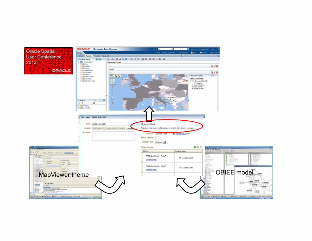
OBIEE 11g Map View feature Thematic Map Visualizations
MapViewer themes Oracle Spatial data
OBIEE Model Common Enterprise Information Model
Web based config Turn-key mapping in dashboards
• Thematic map visualization of any analysis that includes geography • Simple configuration, no coding required • Inherits OBIEE functionality such as Ad Hoc, Drilling, Action Framework, Master-Detail
Linking etc

8
OBIEE Map View Layers
• Dynamic, interactive • “BI Data Layers”
• Tied to OBIEE model
• Thematic rendering of OBIEE analysis results
• “Map Features” • Not associated with OBIEE model
• Provides additional context
• Configured through simple Web GUI

9
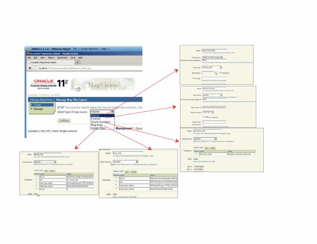
OBIEE Map View Background Maps
• Map Tile Caches • Internal (MapViewer) • Bing • Oracle eLocation • WMS • Nokia • …and the other household name

10
D E M O N S T R A T I O N
Map View Layer and Background Map Configuration

11
Layer and background map config
12
MapViewer theme OBIEE model

13
Theme to use as non-BI layer

14
Import but do not associate with BI column

15
Associate with background map(s)

16
Normal analysis with geographic dimension

17
Map offers “Map Features” since there is now a non-BI layer configured

18
Map Feature added

19
Hosted and WMS background map config
20

21

22
WMS Background Map
• The OpenGIS® Web Map Service Interface Standard (WMS) provides a simple HTTP interface for requesting geo-registered map images from one or more distributed geospatial databases.
• Supported as MapViewer a tilecache source
• Can therefore be an OBIEE background map
National Atlas WMS is used for this demo
23
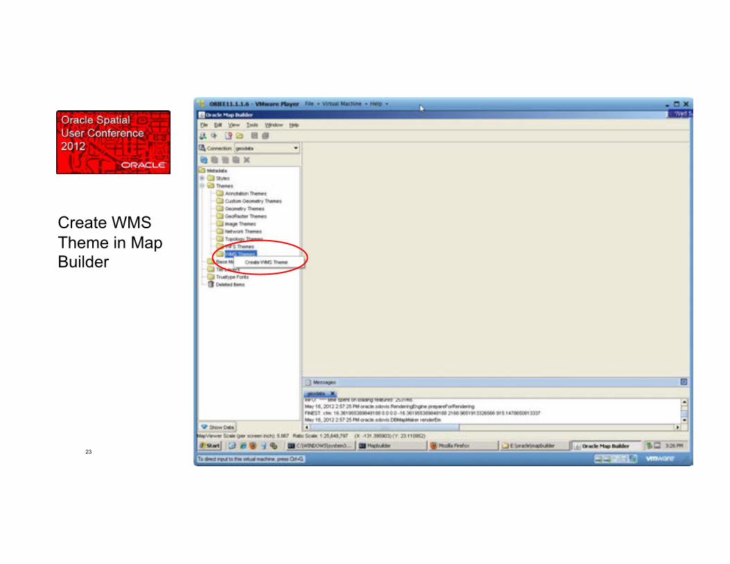
Create WMS Theme in Map Builder
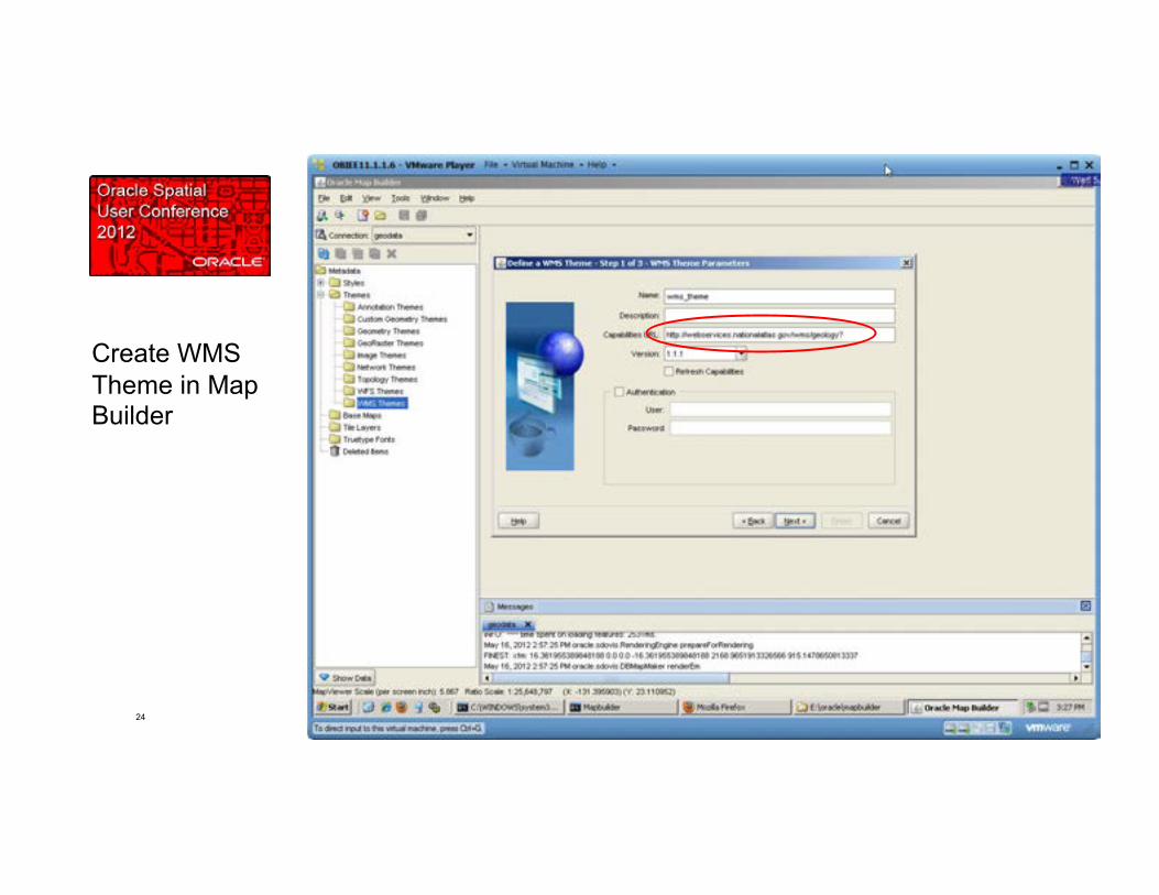
24
Create WMS Theme in Map Builder

25
Create WMS Theme in Map Builder

26
Create WMS Theme in Map Builder
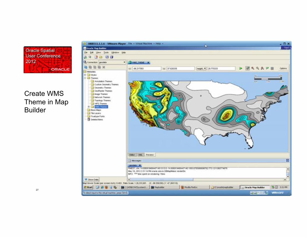
27
Create WMS Theme in Map Builder

28
Create WMS Base Map in Map Builder

29
Create WMS Base Map in Map Builder

30
Create WMS Base Map in Map Builder

31
Create WMS Tilecache in MapViewer web console (or in Map Builder)

32
Create WMS tile layer in MapViewer web console (or in Map Builder)

33
Create WMS tile layer in MapViewer web console (or in Map Builder)

34
Create WMS tile layer in MapViewer web console (or in Map Builder)

35
Associate WMS tile layer with map layers in OBIEE
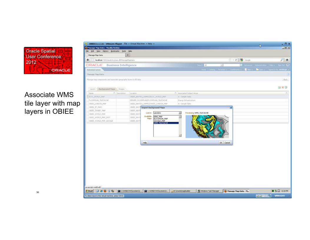
36
Associate WMS tile layer with map layers in OBIEE
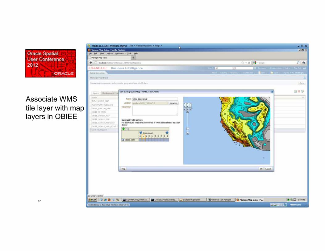
37
Associate WMS tile layer with map layers in OBIEE

38
Create Analysis, render map View, select WMS background map.

39
Spatial Analytics with OBIEE
• Supplements and weaves together the native analytic capabilities of OBIEE with location-based analyses.
• Configured by invoking Oracle Spatial features through supported straightforward OBIEE integration mechanisms.
• Proximity, nearest nbr, within distance, topological operators, geocoding etc etc
• Seamless with other OBIEE data and can be rendered in any OBIEE view (table, chart, map etc)

40
Spatial Analytics Scenario 1
Scenario 1: Column in an analysis based on Spatial function Example: Analysis columns include Customer,Distance_To_Nearest_Store,...
Approach: Define location-based column using EVALUATE() function to ship query to Spatial
EVALUATE(Oracle Spatial functions accepting BI column values…)

41
Spatial Analytics Scenario 2
Scenario 2: Data source in OBIEE model based on Spatial query Example: OBIEE model includes table Stores_Near_Customer
Approach: Define the OBIEE data source as a view that accepts variables sent from the dashboard via user-driven prompts (i.e., Customer, Distance)

42
Spatial Analytics Scenario 3
Scenario 3: Spatial query within OBIEE dashboard, not tied to OBIEE model Example: Select all stores within user defined distance of an address
Approach: Define the query using the “Create Direct Database Request” feature in OBIEE, and include references to variables set by dashboard prompts
43
D E M O N S T R A T I O N
Spatial Analytics using EVALUATE() and OBIEE variables

44
Scenario 1 – using EVALUATE()
45
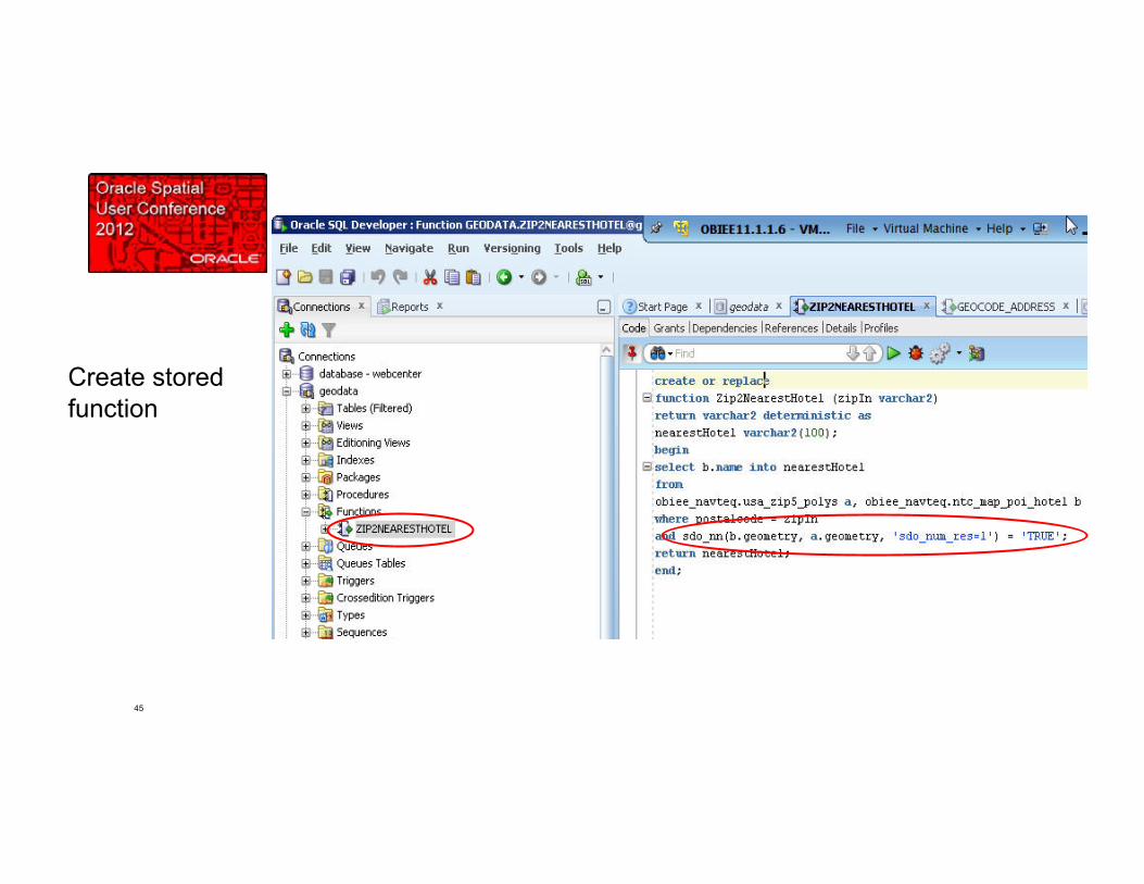
Create stored function

46
Confirm it works

47
Invoke Spatial function with EVALUATE()

48
Our location-based column could be based on any much more involved Spatial operations.

49
EVALUATE() Spatial examples in SampleApp

50
This example constructs geometries from coordinates and feeds into function
51
Scenario 2: using Spatial SQL-based source and session variables

52
Physical source is Spatial SQL with variables

53
Confirm it works (based on variable defaults)

54
Create prompt for Zip and Distance that will set variables

55
Results are dynamic based on passing prompt values to physical layer

56
Physical layer/variable examples in SampleApp

57
This example includes a custom function that invokes the Spatial Geocoder

58
This example includes a custom function that invokes the Spatial Geocoder

59
In OBIEE 11g • Interactive drillable thematic mapping is turn-key
feature • Full arsenal of Oracle Spatial location analysis is
easily integrated

60
Resources
• OBIEE SampleApp “Source Specific Features > Oracle Geospatial” http://www.oracle.com/technetwork/middleware/bi-foundation/obiee-samples-167534.html
• Collaborate 2012 Spatial Analytics Workshop http://www.oracle.com/technetwork/database/options/spatial/overview/resources/ioug-collab12-idx-1609532.html
• OBIEE Documentation Configuring Mapping and Spatial Information http://docs.oracle.com/cd/E23943_01/bi.1111/e10541/configmap.htm
• OBIEE Documentation Creating Map Views http://docs.oracle.com/cd/E23943_01/bi.1111/e10544/creatingviews.htm#sthref165

Q&A
Recommended