International Journal of Technical Innovation in Modern
Engineering & Science (IJTIMES) Impact Factor: 3.45 (SJIF-2015), e-ISSN: 2455-2585
Volume 3, Issue 11, November-2017
IJTIMES-2017@All rights reserved 103
A REVIEW ON SEISMIC PERFORMANCE OF MASONRY STRUCTURE
DURING PAST EARTHQUAKES
A. Sharma1, A. Mittal
2, A. Chauhan
3, V. Baradiya
4
1Professor, Department of Civil Engineering, IES-IPS Academy, Indore 2PG Scholar, Department of Civil Engineering, IES-IPS Academy, Indore 3PG Scholar, Department of Civil Engineering, IES-IPS Academy, Indore
4Professor, Department of Civil Engineering, IES-IPS Academy, Indore
Abstract — The present work investigates the performance of masonry buildings during the most severe
past earthquakes both national and international. The majority of the buildings in the affected region were
built of masonry. The structure shows different types of damage pattern for low to severe earthquake
conditions. Most of the masonry buildings were formed with random or coursed stone and mud brick walls
without any reinforcement and confined masonry buildings. Many of these buildings were damaged or had
collapsed. Generally three types of failure mechanism define the behaviour of masonry structures namely,
sliding shear failure, diagonal shear failure and flexural failure. Confined and reinforced masonry
buildings shows relatively good performance in comparison with other masonry buildings. The damages
are due to several reasons such as poor construction quality and poor workmanship of the buildings. From
the census in India majority (more than 80%) of the buildings is masonry. Thus the present study shows
the need of retrofitting of masonry structures in India.
Keywords— Confine masonry, Diagonal shear failure, Failure mechanism, Flexural failure, Sliding shear
failure.
I. INTRODUCTION
One of the most frightening and destructive phenomena of nature is a severe earthquake and it’s terrible after effects.
Over 80% of the buildings in the India are built of masonry. Mainly three types of structural systems; reinforced
concrete, unreinforced & reinforced masonry and confined masonry are commonly constructed in rural and urban region
in India. Brick masonry construction is widely prevalent among the middle-class population in urban areas and has
become popular in rural areas in the last 30 years. Brick masonry walls in cement mortar function as the main load-
bearing element. If constructed without seismic features, buildings of this type are vulnerable to earthquake effects. They
exhibited rather poor performance during the earthquakes in India.
Many masonry buildings subjected to destructive earthquakes collapsed and were severely damaged due to some
unsuitable designs or some mistakes on projects or applications. Therefore sometimes the idea of unsuitable type of
buildings was adduced for masonry buildings. However, sometimes many masonry buildings especially historical ones
survived the earthquake with only slightly damaged or even undamaged. In spite of the fact that many new reinforced
concrete structures built at the same location have been severely damaged or collapsed. Thus, if masonry buildings are
designed to be resistant against earthquake and constructed with good quality materials, they would survive during the
earthquakes. But in recent earthquake of Nepal (2015) most of the masonry buildings which comes under the category of
monumental buildings performs worst. Although the structural type of masonry buildings varies in different earthquake
zones, their damage resulting from earthquakes can be commonly classified. Many structural deficiencies by the
earthquakes damages are large opening in load bearing walls, lack of especially vertical confining elements, poor qualit y
mortar, heavy balconies and unconfined gable walls.
In this paper a review of past earthquake effect to masonry structures and issues responsible for poor performance,
damages, and failures are presented.
II. PAST EARTHQUAKE DAMAGES TO MASONRY STRUCTURES FROM EARTHQUAKE REPORTS:
1. 1960 VALDIVIA EARTHQUAKE
The 1960 Valdivia earthquake or Great Chilean earthquake (Gran terremoto de Chile) of 22 May was the most
powerful earthquake ever recorded. Various studies have placed it at 9.4–9.6 on the moment magnitude scale. It occurred
in the afternoon (19:11 GMT, 15:11 local time), and lasted approximately 10 minutes.The death toll and monetary losses
arising from this widespread disaster were not certain. Various estimates of the total number of fatalities from the

International Journal of Technical Innovation in Modern Engineering & Science (IJTIMES)
Volume 3, Issue 11, November-2017, e-ISSN: 2455-2585, Impact Factor: 3.45 (SJIF-2015)
IJTIMES-2017@All rights reserved 104
earthquake have been published, ranging between 1,000 and 6,000 killed. Different sources have estimated the monetary
cost ranged from US$400 million to 800 million.
The earthquake shaking caused a wide range of damage to buildings within the affected area. The region has a lots of
old houses, churches, and other buildings built with adobe or unreinforced masonry shown in Fig. 1. Absence of
reinforcement and connection between adjoining walls resulted in the collapse of about 80,000 houses. Falling debris was
a cause to many human deaths. About 300,000 houses and 400 churches were partially collapsed and unsafe to occupy.
One of the historical buildings, Intendencia Regional del Maule, was severely damaged during the earthquake. The
building was a three-story public historical building located in Talcal, Chile. The damage consisted of cracked and
heavily compromise unreinforced masonry walls as well as interior and exterior architectural details and finishes. This
was expected since old buildings such as the Intendencia Regional del Maule was not designed for the current earthquake
knowledge.
Fig. 1 Partially collapse of the building in Valdivia Earthquake.
2. 2004 SUMATRA EARTHQUAKE
The Mw 9.0 earthquake struck at 06:28 a.m. local time in Sri Lanka. Although initial estimates had put the worldwide
death toll at over 275,000 with thousands of others missing, according to the U.S. Geological Survey a total of 227,898
people died. While damage in little Andaman island and all Nicobar island was predominantly tsunami related, that in the
islands north of little Andaman was primarily due to earthquake shaking, though tsunami waves and high tides were also
an issue. In general, the building stock consists of a large number of traditional and non-engineered. Many traditional
structures were made of wood, and they performed well in the earthquake shaking. However, a number of new, poorly
constructed masonry structures suffered severe damage or even collapse due to shaking as shown in Fig 2.
Most of buildings on the east coast of Sri Lanka are made of bricks. Damage to these buildings was most apparent in
regions where part of the building was left standing. However, in most cases, the only indication of a pre existing
building was a remnant of a foundation. In some areas, there was a zone near the coast where all structures were
completely destroyed; however, the damage to structures varied over short stretches of coast.
In one part of Kalmunai, the zone of destruction extended about 0.5 km inland, but less than 2 km from there, most of
the structures were standing and relatively undamaged at distances greater than 100m from the shoreline. This variability
may have resulted from differences in both the tsunami heights and the quality of construction. Large scour was noted in
most areas, which appeared to result from both the incoming and returning flow, undermining the foundations of many
structures. In masonry load-bearing walls and light roof trusses made of either steel pipes or timber, walls were not tied
together to create lateral resistance. Large movement of the flexible roofs from earthquake forces caused out-of-plane
masonry wall collapse. Similar damage was observed at a much larger scale in many school buildings, where the long
partition walls separating two classrooms were either badly damaged or had fallen due to out-of-plane instability.
Fig. 2 Total collapse of the building in Sumatra Earthquake
International Journal of Technical Innovation in Modern Engineering & Science (IJTIMES)
Volume 3, Issue 11, November-2017, e-ISSN: 2455-2585, Impact Factor: 3.45 (SJIF-2015)
IJTIMES-2017@All rights reserved 105
3. 2011 TOHOKU EARTHQUAKE
The 2011 earthquake off the pacific coast of Tohoku was a magnitude 9.0-9.1 under sea mega thrust earthquake off
the coast of Japan that occurred at 14:46 JST (05:46 UTC) on Friday 11 March 2011, with the epicenter approximately
70 kilometer east of Oshika Peninsula of Tohoku and the hypocenter at an underwater depth of approximately 29 km.
The earthquake was often referred to in Japan as the Great East Japan Earthquake and was also known as the 2011
Tohoku earthquake.
Report confirmed 15,894 deaths, 6152 injured and 2,562 people missing across twenty prefectures, as well as
228,863 people living away from their home in either temporary housing or due to permanent relocation. An report
listed 1,27,290 buildings totally collapsed, with a further 2,72,788 buildings "half collapsed", and another 7,47,989
buildings partially damaged.
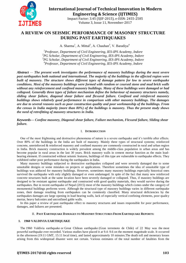
Damage to the engineered constructions was limited to broken doors, windows, and masonry failures. Masonry walls
suffered out of plane failures and were jettisoned in great distance, mainly in buildings constructed near the shoreline.
Almost all of the damaged buildings were designed in accordance with the old building code and damaged due to lack of
seismic strength, short column shear failure due to the source wall or the eccentricity of structural elements. In most
cases masonry walls out of plane punching shear failures and pounding failure were observed as shown in Fig 3.
Buildings with appropriate seismic reinforcement/retrofit were mostly free of damage, indicating that the seismic
reinforcement/retrofit of buildings was effective. Even so, clear structural damage occurred due to the ground motion
amplification. The 8 and 9 story buildings at aobayama campus of Tohoku University were damaged due to ground
motion amplification in the site. Many pile foundation buildings were damaged during the earthquake.
Fig.3 Pounding failure in Tohoku Earthquake
4. 1952 KAMCHATKA EARTHQUAKE
The Kamchatka Tsunami was generated by a magnitude 9.0 earthquake on November 4, 1952, in East Russia. The
local tsunami, which generated waves as high as 50 feet, caused extensive damage to the Kamchatka Peninsula and the
Kuril Islands, and left an estimated 10,000 to 15,000 people dead. Waves traveled as far as Peru, Chili and New Zealand,
but the largest damage to other areas of the Pacific Ocean occurred in the Hawaiian Islands.Masonry structures were also
widely distributed across this region even though their numbers are less than wooden buildings. Buildings built with tuff
stone called nobirustone (shiogama-stone) produced in the Shiogama City region of Miyagi Prefecture were widely
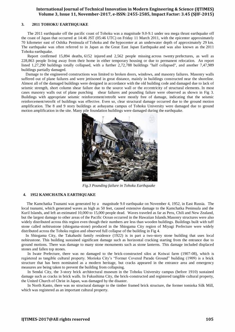
distributed across the Tohoku region and observed full collapse of the building in Fig 4.
In Shiogama City, the Takahashi family residence (1922) is in part a two-story stone building that uses local
nobirustone. This building sustained significant damage such as horizontal cracking starting from the entrance due to
ground motions. There was damage to many stone monuments such as stone lanterns. This damage included displaced
stones and fallen top stones.
In Iwate Prefecture, there was no damaged to the brick-constructed silos at Koiwai farm (1907-08), which is
registered as tangible cultural property. Morioka City’s “Former Covered Parade Ground” building (1909) is a brick
structure that has been nominated as a modern heritage, but cracks appeared in the entrance area and emergency
measures are being taken to prevent the building from collapsing.
In Sendai City, the 3-story brick architectural museum in the Tohoku University campus (before 1910) sustained
damage such as cracks in brick walls. In Fukushima City, the brick-constructed and registered tangible cultural property,
the United Church of Christ in Japan, was damaged by the disaster.
In North Kanto, there was no structural damage to the timber framed brick structure, the former tomioka Silk Mill,
which was registered as an important cultural property.
International Journal of Technical Innovation in Modern Engineering & Science (IJTIMES)
Volume 3, Issue 11, November-2017, e-ISSN: 2455-2585, Impact Factor: 3.45 (SJIF-2015)
IJTIMES-2017@All rights reserved 106
Fig.4 Total collapse of the building in Kamchatka Earthquake.
5. 2010 MAULE EARTHQUAKE
The 2010 Chile earthquake occurred off the coast of central Chile on Saturday, 27 February at 03:34 local
time (06:34 UTC), having a magnitude of 8.8 on the moment magnitude scale, with intense shaking lasting for about
three minutes. It was felt strongly in six Chilean regions that together make up about 80 percent of the country's
population.
In Chile, 370,000 homes were damaged. The final death toll of 525 victims and 25 people missing was announced by
authorities in January 2011. This is down from early reports on 3 March of 802 people dead. Earthquake's losses to the
economy of Chile are estimated at US$15–30 billion.
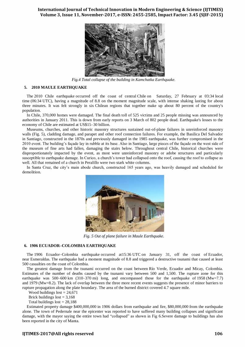
Museums, churches, and other historic masonry structures sustained out-of-plane failures in unreinforced masonry
walls (Fig. 5), cladding damage, and parapet and other roof connection failures. For example, the Basilica Del Salvador
in Santiago, constructed in the 1870s and previously damaged in the 1985 earthquake, was further compromised in the
2010 event. The building’s façade lay in rubble at its base. Also in Santiago, large pieces of the façade on the west side of
the museum of fine arts had fallen, damaging the stairs below. Throughout central Chile, historical churches were
disproportionately impacted by the event, as most were unreinforced masonry or adobe structures and particularly
susceptible to earthquake damage. In Curico, a church’s tower had collapsed onto the roof, causing the roof to collapse as
well. All that remained of a church in Peralillo were two stark white columns.
In Santa Cruz, the city’s main abode church, constructed 165 years ago, was heavily damaged and scheduled for
demolition.
Fig. 5 Out of plane failure in Maule Earthquake.
6. 1906 ECUADOR–COLOMBIA EARTHQUAKE
The 1906 Ecuador–Colombia earthquake occurred at15:36 UTC on January 31, off the coast of Ecuador,
near Esmeraldas. The earthquake had a moment magnitude of 8.8 and triggered a destructive tsunami that caused at least
500 casualties on the coast of Colombia.
The greatest damage from the tsunami occurred on the coast between Río Verde, Ecuador and Micay, Colombia.
Estimates of the number of deaths caused by the tsunami vary between 500 and 1,500. The rupture zone for this
earthquake was 500–600 km (310–370 mi) long, and encompassed those for the earthquake of 1958 (Mw=7.7)
and 1979 (Mw=8.2). The lack of overlap between the three more recent events suggests the presence of minor barriers to
rupture propagation along the plate boundary. The area of the burned district covered 4.7 square mile.
Wood buildings lost = 24,671
Brick buildings lost = 3,168
Total buildings lost = 28,188
Estimated property damage $400,000,000 in 1906 dollars from earthquake and fire, $80,000,000 from the earthquake
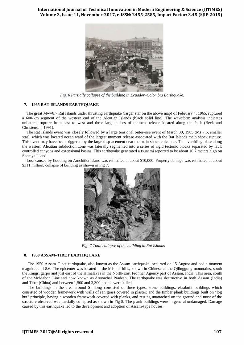
alone. The town of Pedernale near the epicenter was reported to have suffered many building collapses and significant
damage, with the mayor saying the entire town had “collapsed” as shown in Fig 6.Severe damage to buildings has also
been reported in the city of Manta.
International Journal of Technical Innovation in Modern Engineering & Science (IJTIMES)
Volume 3, Issue 11, November-2017, e-ISSN: 2455-2585, Impact Factor: 3.45 (SJIF-2015)
IJTIMES-2017@All rights reserved 107
Fig. 6 Partially collapse of the building in Ecuador–Colombia Earthquake.
7. 1965 RAT ISLANDS EARTHQUAKE
The great Mw=8.7 Rat Islands under thrusting earthquake (larger star on the above map) of February 4, 1965, ruptured
a 600-km segment of the western end of the Aleutian Islands (black solid line). The waveform analysis indicates
unilateral rupture from east to west and three large pulses of moment release located along the fault (Beck and
Christensen, 1991).
The Rat Islands event was closely followed by a large tensional outer-rise event of March 30, 1965 (Ms 7.5, smaller
star), which was located ocean ward of the largest moment release associated with the Rat Islands main shock rupture.
This event may have been triggered by the large displacement near the main shock epicenter. The overriding plate along
the western Aleutian subduction zone was laterally segmented into a series of rigid tectonic blocks separated by fault
controlled canyons and extensional basins. This earthquake generated a tsunami reported to be about 10.7 meters high on
Shemya Island.
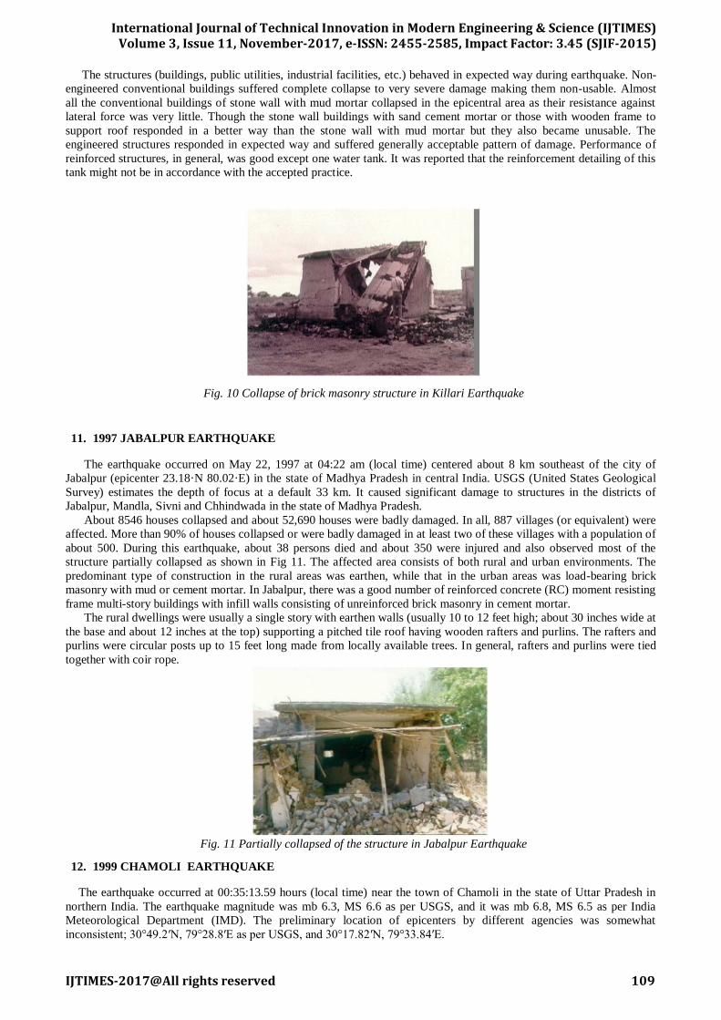
Loss caused by flooding on Amchitka Island was estimated at about $10,000. Property damage was estimated at about
$311 million, collapse of building as shown in Fig 7.
Fig. 7 Total collapse of the building in Rat Islands
8. 1950 ASSAM–TIBET EARTHQUAKE
The 1950 Assam–Tibet earthquake, also known as the Assam earthquake, occurred on 15 August and had a moment
magnitude of 8.6. The epicenter was located in the Mishmi hills, known in Chinese as the Qilinggong mountains, south
the Kangri garpo and just east of the Himalayas in the North-East Frontier Agency part of Assam, India. This area, south
of the McMahon Line and now known as Arunachal Pradesh. The earthquake was destructive in both Assam (India)
and Tibet (China) and between 1,500 and 3,300 people were killed.
The buildings in the area around Shillong consisted of three types: stone buildings; ekrabuilt buildings which
consisted of wooden framework with walls of san grass covered in plaster; and the timber plank buildings built on "log
hut" principle, having a wooden framework covered with planks, and resting unattached on the ground and most of the
structure observed was partially collapsed as shown in Fig 8. The plank buildings were in general undamaged. Damage
caused by this earthquake led to the development and adoption of Assam-type houses.

International Journal of Technical Innovation in Modern Engineering & Science (IJTIMES)
Volume 3, Issue 11, November-2017, e-ISSN: 2455-2585, Impact Factor: 3.45 (SJIF-2015)
IJTIMES-2017@All rights reserved 108
Fig. 8 Partially collapsed of the building in Assam-Tibet Earthquake.
9. 1991 UTTARKASHI EARTHQUAKE
The magnitude of the earthquake was assigned as 6.1 by the Indian Meteorological Department (IMD) based on body
wave data. The USGS assigned a surface wave magnitude of 7.1. There was confusion about epicenter of the earthquake,
with preliminary estimates by IMD indicating its location close to Almora, about 170 km from Uttarkashi.
Uttarkashi has a number of three and four story reinforced concrete (RC) framed buildings which sustained damage.
Shear-cracks developed in the ground floor columns of two stories Post Office Building in Uttarkashi built in 1985-86 by
engineers of the department of post and telegraphs. The strong floor beams in the frame forced the yielding into ground-
story columns. The weaker roof beams sustain flexural hairline cracks while the supporting second story columns were
damaged. Most government buildings, both offices and residences, are one or two story buildings with load bearing walls
and sloping roofs. Older construction was of unreinforced random rubble stone masonry which performed very poorly
and observed full structures were collapse. The newer construction was of unreinforced concrete block masonry and
usually includes a RC band at lintel level. The ITBP Paramilitary Campus at Mahidanda consists a large number of two
story residential buildings with load bearing walls of concrete masonry. All have RC lintel bands, but no roof bands or
gable bands. The construction was about 10 years old. The damage to buildings consisted of (I) diagonal cracks below
window sills, (ii) damage at the connection between masonry walls and RC roof slabs, (iii) in buildings with corrugated
iron sheet roofs, damage at seat of purlins on the gable end walls, and (iv) damage to walls supporting roofs at different
heights at either end (Fig. 9).
Fig. 9 Damage to wall supporting Split Level roof - ITBP campus, Mahidanda, Uttarkashi Earthquake
10. 1993 KILLARI EARTHQUAKE
A very active swarm between August and October 1992 (125 felt events in Killari); the largest event on October 18,
1992 (mb=4.5) caused damage to many stone/mud buildings in Killari. Centred near the village of Killari, Latur district,
Maharashtra State, Central India (18.2N; 76.4E).
The collapse of traditional stone-and-mud buildings in the mesoseismal area was nearly total. The wood-plank roofs
of these single-story dwellings typically are topped with a 30-60 cm thick layer of clay to provide protection from rain
and heat. All such constructions behaved very poorly due to the heavy mass at the roof and the poor strength of the
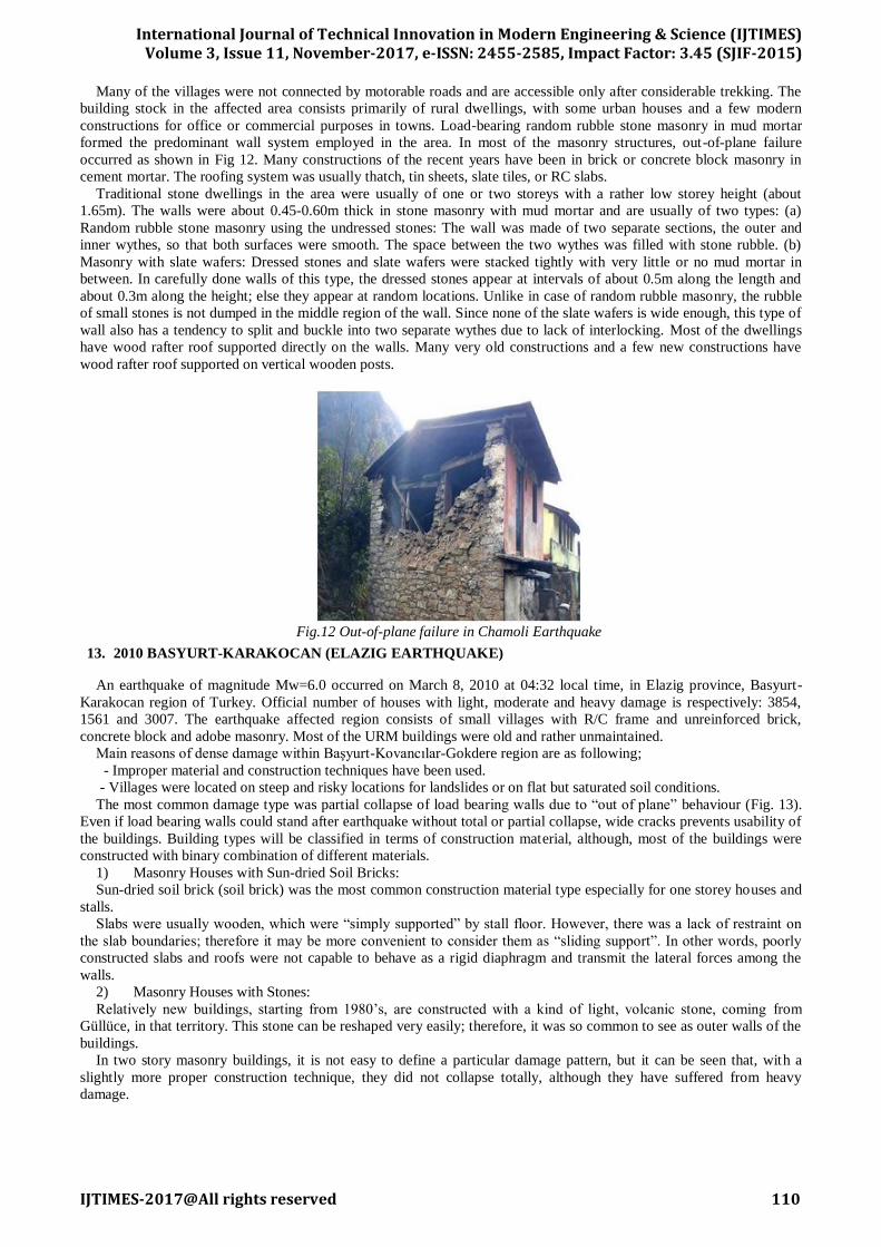
supporting rubble masonry walls; such houses were the main cause for the high number of casualties as shown in Fig 10.
Some houses were made of load-bearing walls of burnt-clay bricks in cement mortar supporting either a reinforced
concrete slab or a corrugated sheet roof. In a residential colony at Killari, a house supporting heavy reinforced concrete
roof sustained severe wall cracks, while the adjoining one supporting a light roof of corrugated asbestos sheets sustained
only hairline cracks in the walls. Surprisingly, a few brick masonry houses in the area were found to have concrete lintel
bands. Such houses performed very well with no damage.
International Journal of Technical Innovation in Modern Engineering & Science (IJTIMES)
Volume 3, Issue 11, November-2017, e-ISSN: 2455-2585, Impact Factor: 3.45 (SJIF-2015)
IJTIMES-2017@All rights reserved 109
The structures (buildings, public utilities, industrial facilities, etc.) behaved in expected way during earthquake. Non-
engineered conventional buildings suffered complete collapse to very severe damage making them non-usable. Almost
all the conventional buildings of stone wall with mud mortar collapsed in the epicentral area as their resistance against
lateral force was very little. Though the stone wall buildings with sand cement mortar or those with wooden frame to
support roof responded in a better way than the stone wall with mud mortar but they also became unusable. The
engineered structures responded in expected way and suffered generally acceptable pattern of damage. Performance of
reinforced structures, in general, was good except one water tank. It was reported that the reinforcement detailing of this
tank might not be in accordance with the accepted practice.
Fig. 10 Collapse of brick masonry structure in Killari Earthquake
11. 1997 JABALPUR EARTHQUAKE
The earthquake occurred on May 22, 1997 at 04:22 am (local time) centered about 8 km southeast of the city of
Jabalpur (epicenter 23.18·N 80.02·E) in the state of Madhya Pradesh in central India. USGS (United States Geological
Survey) estimates the depth of focus at a default 33 km. It caused significant damage to structures in the districts of
Jabalpur, Mandla, Sivni and Chhindwada in the state of Madhya Pradesh.
About 8546 houses collapsed and about 52,690 houses were badly damaged. In all, 887 villages (or equivalent) were
affected. More than 90% of houses collapsed or were badly damaged in at least two of these villages with a population of
about 500. During this earthquake, about 38 persons died and about 350 were injured and also observed most of the
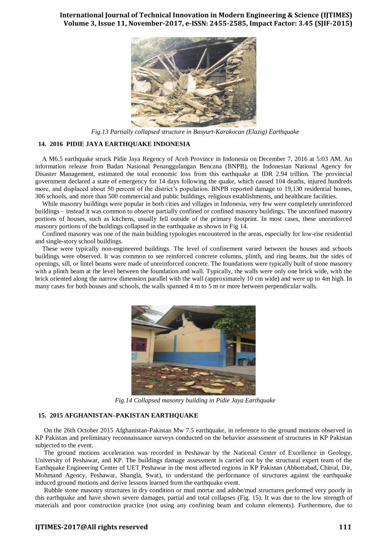
structure partially collapsed as shown in Fig 11. The affected area consists of both rural and urban environments. The
predominant type of construction in the rural areas was earthen, while that in the urban areas was load-bearing brick
masonry with mud or cement mortar. In Jabalpur, there was a good number of reinforced concrete (RC) moment resisting
frame multi-story buildings with infill walls consisting of unreinforced brick masonry in cement mortar.
The rural dwellings were usually a single story with earthen walls (usually 10 to 12 feet high; about 30 inches wide at
the base and about 12 inches at the top) supporting a pitched tile roof having wooden rafters and purlins. The rafters and
purlins were circular posts up to 15 feet long made from locally available trees. In general, rafters and purlins were tied
together with coir rope.
Fig. 11 Partially collapsed of the structure in Jabalpur Earthquake
12. 1999 CHAMOLI EARTHQUAKE
The earthquake occurred at 00:35:13.59 hours (local time) near the town of Chamoli in the state of Uttar Pradesh in
northern India. The earthquake magnitude was mb 6.3, MS 6.6 as per USGS, and it was mb 6.8, MS 6.5 as per India
Meteorological Department (IMD). The preliminary location of epicenters by different agencies was somewhat
inconsistent; 30°49.2′N, 79°28.8′E as per USGS, and 30°17.82′N, 79°33.84′E.
International Journal of Technical Innovation in Modern Engineering & Science (IJTIMES)
Volume 3, Issue 11, November-2017, e-ISSN: 2455-2585, Impact Factor: 3.45 (SJIF-2015)
IJTIMES-2017@All rights reserved 110
Many of the villages were not connected by motorable roads and are accessible only after considerable trekking. The
building stock in the affected area consists primarily of rural dwellings, with some urban houses and a few modern
constructions for office or commercial purposes in towns. Load-bearing random rubble stone masonry in mud mortar
formed the predominant wall system employed in the area. In most of the masonry structures, out-of-plane failure
occurred as shown in Fig 12. Many constructions of the recent years have been in brick or concrete block masonry in
cement mortar. The roofing system was usually thatch, tin sheets, slate tiles, or RC slabs.
Traditional stone dwellings in the area were usually of one or two storeys with a rather low storey height (about
1.65m). The walls were about 0.45-0.60m thick in stone masonry with mud mortar and are usually of two types: (a)
Random rubble stone masonry using the undressed stones: The wall was made of two separate sections, the outer and
inner wythes, so that both surfaces were smooth. The space between the two wythes was filled with stone rubble. (b)
Masonry with slate wafers: Dressed stones and slate wafers were stacked tightly with very little or no mud mortar in
between. In carefully done walls of this type, the dressed stones appear at intervals of about 0.5m along the length and
about 0.3m along the height; else they appear at random locations. Unlike in case of random rubble masonry, the rubble
of small stones is not dumped in the middle region of the wall. Since none of the slate wafers is wide enough, this type of
wall also has a tendency to split and buckle into two separate wythes due to lack of interlocking. Most of the dwellings
have wood rafter roof supported directly on the walls. Many very old constructions and a few new constructions have
wood rafter roof supported on vertical wooden posts.
Fig.12 Out-of-plane failure in Chamoli Earthquake
13. 2010 BASYURT-KARAKOCAN (ELAZIG EARTHQUAKE)
An earthquake of magnitude Mw=6.0 occurred on March 8, 2010 at 04:32 local time, in Elazig province, Basyurt-
Karakocan region of Turkey. Official number of houses with light, moderate and heavy damage is respectively: 3854,
1561 and 3007. The earthquake affected region consists of small villages with R/C frame and unreinforced brick,
concrete block and adobe masonry. Most of the URM buildings were old and rather unmaintained.
Main reasons of dense damage within Başyurt-Kovancılar-Gokdere region are as following;
- Improper material and construction techniques have been used.
- Villages were located on steep and risky locations for landslides or on flat but saturated soil conditions.
The most common damage type was partial collapse of load bearing walls due to “out of plane” behaviour (Fig. 13).
Even if load bearing walls could stand after earthquake without total or partial collapse, wide cracks prevents usability of
the buildings. Building types will be classified in terms of construction material, although, most of the buildings were
constructed with binary combination of different materials.
1) Masonry Houses with Sun-dried Soil Bricks:
Sun-dried soil brick (soil brick) was the most common construction material type especially for one storey houses and
stalls.
Slabs were usually wooden, which were “simply supported” by stall floor. However, there was a lack of restraint on
the slab boundaries; therefore it may be more convenient to consider them as “sliding support”. In other words, poorly
constructed slabs and roofs were not capable to behave as a rigid diaphragm and transmit the lateral forces among the
walls.
2) Masonry Houses with Stones:
Relatively new buildings, starting from 1980’s, are constructed with a kind of light, volcanic stone, coming from
Güllüce, in that territory. This stone can be reshaped very easily; therefore, it was so common to see as outer walls of the
buildings.
In two story masonry buildings, it is not easy to define a particular damage pattern, but it can be seen that, with a
slightly more proper construction technique, they did not collapse totally, although they have suffered from heavy
damage.
International Journal of Technical Innovation in Modern Engineering & Science (IJTIMES)
Volume 3, Issue 11, November-2017, e-ISSN: 2455-2585, Impact Factor: 3.45 (SJIF-2015)
IJTIMES-2017@All rights reserved 111
Fig.13 Partially collapsed structure in Basyurt-Karakocan (Elazig) Earthquake
14. 2016 PIDIE JAYA EARTHQUAKE INDONESIA
A M6.5 earthquake struck Pidie Jaya Regency of Aceh Province in Indonesia on December 7, 2016 at 5:03 AM. An
information release from Badan Nasional Penanggulangan Bencana (BNPB), the Indonesian National Agency for
Disaster Management, estimated the total economic loss from this earthquake at IDR 2.94 trillion. The provincial
government declared a state of emergency for 14 days following the quake, which caused 104 deaths, injured hundreds
more, and displaced about 50 percent of the district’s population. BNPB reported damage to 19,130 residential homes,
306 schools, and more than 500 commercial and public buildings, religious establishments, and healthcare facilities.
While masonry buildings were popular in both cities and villages in Indonesia, very few were completely unreinforced
buildings – instead it was common to observe partially confined or confined masonry buildings. The unconfined masonry
portions of houses, such as kitchens, usually fell outside of the primary footprint. In most cases, these unreinforced
masonry portions of the buildings collapsed in the earthquake as shown in Fig 14.
Confined masonry was one of the main building typologies encountered in the areas, especially for low-rise residential
and single-story school buildings.
These were typically non-engineered buildings. The level of confinement varied between the houses and schools
buildings were observed. It was common to see reinforced concrete columns, plinth, and ring beams, but the sides of
openings, sill, or lintel beams were made of unreinforced concrete. The foundations were typically built of stone masonry
with a plinth beam at the level between the foundation and wall. Typically, the walls were only one brick wide, with the
brick oriented along the narrow dimension parallel with the wall (approximately 10 cm wide) and were up to 4m high. In
many cases for both houses and schools, the walls spanned 4 m to 5 m or more between perpendicular walls.
Fig.14 Collapsed masonry building in Pidie Jaya Earthquake
15. 2015 AFGHANISTAN–PAKISTAN EARTHQUAKE
On the 26th October 2015 Afghanistan-Pakistan Mw 7.5 earthquake, in reference to the ground motions observed in
KP Pakistan and preliminary reconnaissance surveys conducted on the behavior assessment of structures in KP Pakistan
subjected to the event.
The ground motions acceleration was recorded in Peshawar by the National Center of Excellence in Geology,
University of Peshawar, and KP. The buildings damage assessment is carried out by the structural expert team of the
Earthquake Engineering Center of UET Peshawar in the most affected regions in KP Pakistan (Abbottabad, Chitral, Dir,
Mohmand Agency, Peshawar, Shangla, Swat), to understand the performance of structures against the earthquake
induced ground motions and derive lessons learned from the earthquake event.
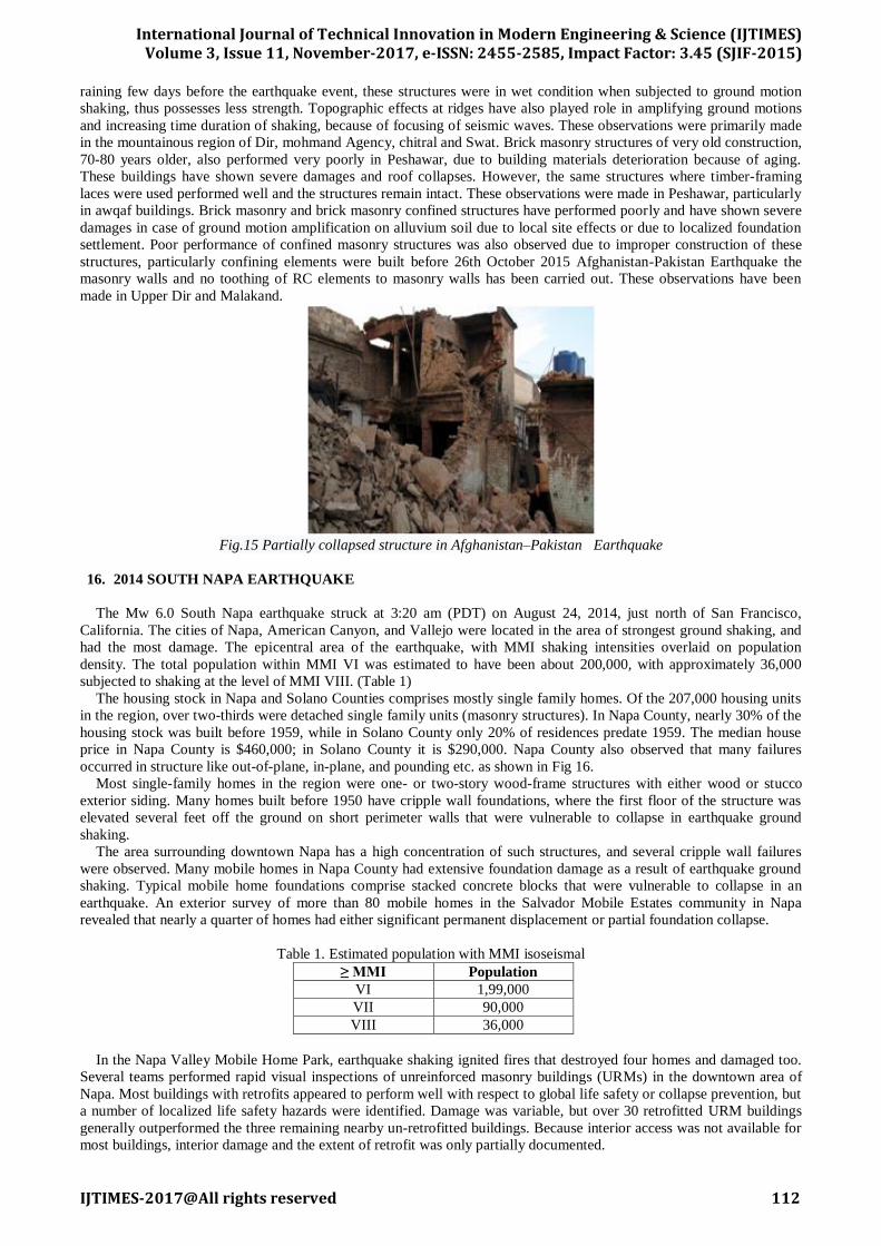
Rubble stone masonry structures in dry condition or mud mortar and adobe/mud structures performed very poorly in
this earthquake and have shown severe damages, partial and total collapses (Fig. 15). It was due to the low strength of
materials and poor construction practice (not using any confining beam and column elements). Furthermore, due to
International Journal of Technical Innovation in Modern Engineering & Science (IJTIMES)
Volume 3, Issue 11, November-2017, e-ISSN: 2455-2585, Impact Factor: 3.45 (SJIF-2015)
IJTIMES-2017@All rights reserved 112
raining few days before the earthquake event, these structures were in wet condition when subjected to ground motion
shaking, thus possesses less strength. Topographic effects at ridges have also played role in amplifying ground motions
and increasing time duration of shaking, because of focusing of seismic waves. These observations were primarily made
in the mountainous region of Dir, mohmand Agency, chitral and Swat. Brick masonry structures of very old construction,
70-80 years older, also performed very poorly in Peshawar, due to building materials deterioration because of aging.
These buildings have shown severe damages and roof collapses. However, the same structures where timber-framing
laces were used performed well and the structures remain intact. These observations were made in Peshawar, particularly
in awqaf buildings. Brick masonry and brick masonry confined structures have performed poorly and have shown severe
damages in case of ground motion amplification on alluvium soil due to local site effects or due to localized foundation
settlement. Poor performance of confined masonry structures was also observed due to improper construction of these
structures, particularly confining elements were built before 26th October 2015 Afghanistan-Pakistan Earthquake the
masonry walls and no toothing of RC elements to masonry walls has been carried out. These observations have been
made in Upper Dir and Malakand.
Fig.15 Partially collapsed structure in Afghanistan–Pakistan Earthquake
16. 2014 SOUTH NAPA EARTHQUAKE
The Mw 6.0 South Napa earthquake struck at 3:20 am (PDT) on August 24, 2014, just north of San Francisco,
California. The cities of Napa, American Canyon, and Vallejo were located in the area of strongest ground shaking, and
had the most damage. The epicentral area of the earthquake, with MMI shaking intensities overlaid on population
density. The total population within MMI VI was estimated to have been about 200,000, with approximately 36,000
subjected to shaking at the level of MMI VIII. (Table 1)
The housing stock in Napa and Solano Counties comprises mostly single family homes. Of the 207,000 housing units
in the region, over two-thirds were detached single family units (masonry structures). In Napa County, nearly 30% of the
housing stock was built before 1959, while in Solano County only 20% of residences predate 1959. The median house
price in Napa County is $460,000; in Solano County it is $290,000. Napa County also observed that many failures
occurred in structure like out-of-plane, in-plane, and pounding etc. as shown in Fig 16.
Most single-family homes in the region were one- or two-story wood-frame structures with either wood or stucco
exterior siding. Many homes built before 1950 have cripple wall foundations, where the first floor of the structure was
elevated several feet off the ground on short perimeter walls that were vulnerable to collapse in earthquake ground
shaking.
The area surrounding downtown Napa has a high concentration of such structures, and several cripple wall failures
were observed. Many mobile homes in Napa County had extensive foundation damage as a result of earthquake ground
shaking. Typical mobile home foundations comprise stacked concrete blocks that were vulnerable to collapse in an
earthquake. An exterior survey of more than 80 mobile homes in the Salvador Mobile Estates community in Napa
revealed that nearly a quarter of homes had either significant permanent displacement or partial foundation collapse.
Table 1. Estimated population with MMI isoseismal
≥ MMI Population
VI 1,99,000
VII 90,000
VIII 36,000
In the Napa Valley Mobile Home Park, earthquake shaking ignited fires that destroyed four homes and damaged too.
Several teams performed rapid visual inspections of unreinforced masonry buildings (URMs) in the downtown area of
Napa. Most buildings with retrofits appeared to perform well with respect to global life safety or collapse prevention, but
a number of localized life safety hazards were identified. Damage was variable, but over 30 retrofitted URM buildings
generally outperformed the three remaining nearby un-retrofitted buildings. Because interior access was not available for
most buildings, interior damage and the extent of retrofit was only partially documented.

International Journal of Technical Innovation in Modern Engineering & Science (IJTIMES)
Volume 3, Issue 11, November-2017, e-ISSN: 2455-2585, Impact Factor: 3.45 (SJIF-2015)
IJTIMES-2017@All rights reserved 113
Fig.16 Out-of-plane failure in South Napa Earthquake
17. 2002 MOLISE, ITALY, EARTHQUAKE
At 11:32 am (local time) on October 31, 2002, a magnitude Mw 5.7 earthquake struck the inland part of Molise, a
small rural region in the southeastern part of the Italian peninsula. The epicenter was located about 220 km southeast of
Rome, but the earthquake was felt as far away as Naples and the Italian capital. This earthquake caused widespread
damage in 50 villages and killed 30 people, 27 of whom were children trapped in the collapse of the elementary school in
San Giuliano di Puglia.
The Molise earthquake sequence damaged towns in the Campobasso Province in Molise and in the Foggia Province in
Puglia. San Giuliano di Puglia, Bonefro, Santa Croce di Magliano, Ripabottoni, Castellino del Biferno, and Casalnuovo
Monterotaro were the most affected towns. As of December 15, 2002, about 15,000 inspections had been made in Molise
and about 2,000 in Puglia. In San Giuliano alone about 300 buildings have already been declared unsafe and will
probably be demolished. The inspection survey considered six tagging conditions: A (usable with no restrictions), B
(usable with conditions); C (partially usable); D (to be inspected again); E (not usable); F (not usable because of damage
to adjacent buildings). The preliminary breakdown of the inspections in the six most affected towns are shown in Table
2.
Table 2. Post earthquake building inspection in the most damaged towns.
Comune Total A B C D E
S. Giuliano 590 160 55 11 21 298
S. Croce 1453 1073 123 48 19 170
Ripabottoni 895 428 75 55 56 232
Castellino 544 2720 29 16 18 166
Bonefro 1203 740 143 20 5 245
Better construction practices and, probably, lower ground shaking made older buildings perform relatively well, with
many fewer collapses than more modern construction. Some significant examples of damage to older buildings include
out-of-plane failures of walls and failure of the roof-supporting structure as shown in Fig 17.
Some interior damage, with partial detachment of the façade from the exterior wall, was also observed in the historical
part of Casalnuovo Monterotaro. Some of the collapses in the older buildings occurred in buildings that were abandoned
and in an acute state of disrepair. All the damage mechanisms typical of stone-wall and brick-wall buildings were
observed in the relatively newer structures located in the developments outside the old town.
Fig.17 Out of plane failure of building in Molise Earthquake
18. 2005 KASHMIR EARTHQUAKE
On October 8, 2005, at 08:50 am local time, a Mw7.6 earthquake struck the Kashmiri region of Pakistan and India,
causing widespread destruction in Pakistan’s Azad Jammu and Kashmir (AJK) and North-west Frontier Provinces
International Journal of Technical Innovation in Modern Engineering & Science (IJTIMES)
Volume 3, Issue 11, November-2017, e-ISSN: 2455-2585, Impact Factor: 3.45 (SJIF-2015)
IJTIMES-2017@All rights reserved 114
(NWFP), & in India’s western and southern Kashmir an area of 30,000 km2. This was the deadliest earthquake in the
recent history of the sub-continent, with more than 80,000 fatalities, 200,000 people injured, and more than 4 million
people left homeless.
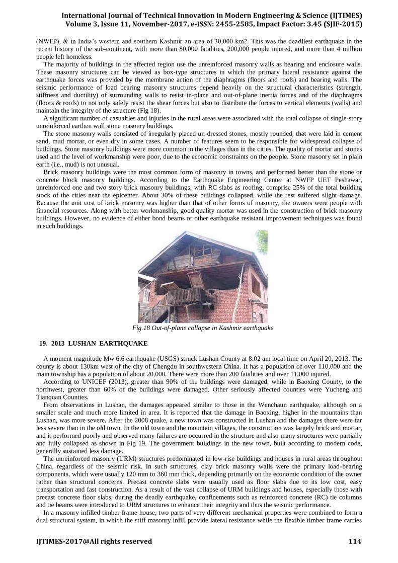
The majority of buildings in the affected region use the unreinforced masonry walls as bearing and enclosure walls.
These masonry structures can be viewed as box-type structures in which the primary lateral resistance against the
earthquake forces was provided by the membrane action of the diaphragms (floors and roofs) and bearing walls. The
seismic performance of load bearing masonry structures depend heavily on the structural characteristics (strength,
stiffness and ductility) of surrounding walls to resist in-plane and out-of-plane inertia forces and of the diaphragms
(floors & roofs) to not only safely resist the shear forces but also to distribute the forces to vertical elements (walls) and
maintain the integrity of the structure (Fig 18).
A significant number of casualties and injuries in the rural areas were associated with the total collapse of single-story
unreinforced earthen wall stone masonry buildings.
The stone masonry walls consisted of irregularly placed un-dressed stones, mostly rounded, that were laid in cement
sand, mud mortar, or even dry in some cases. A number of features seem to be responsible for widespread collapse of
buildings. Stone masonry buildings were more common in the villages than in the cities. The quality of mortar and stones
used and the level of workmanship were poor, due to the economic constraints on the people. Stone masonry set in plain
earth (i.e., mud) is not unusual.
Brick masonry buildings were the most common form of masonry in towns, and performed better than the stone or
concrete block masonry buildings. According to the Earthquake Engineering Center at NWFP UET Peshawar,
unreinforced one and two story brick masonry buildings, with RC slabs as roofing, comprise 25% of the total building
stock of the cities near the epicenter. About 30% of these buildings collapsed, while the rest suffered slight damage.
Because the unit cost of brick masonry was higher than that of other forms of masonry, the owners were people with
financial resources. Along with better workmanship, good quality mortar was used in the construction of brick masonry
buildings. However, no evidence of either bond beams or other earthquake resistant improvement techniques was found
in such buildings.
Fig.18 Out-of-plane collapse in Kashmir earthquake
19. 2013 LUSHAN EARTHQUAKE
A moment magnitude Mw 6.6 earthquake (USGS) struck Lushan County at 8:02 am local time on April 20, 2013. The
county is about 130km west of the city of Chengdu in southwestern China. It has a population of over 110,000 and the
main township has a population of about 20,000. There were more than 200 fatalities and over 11,000 injured.
According to UNICEF (2013), greater than 90% of the buildings were damaged, while in Baoxing County, to the
northwest, greater than 60% of the buildings were damaged. Other seriously affected counties were Yucheng and
Tianquan Counties.
From observations in Lushan, the damages appeared similar to those in the Wenchaun earthquake, although on a
smaller scale and much more limited in area. It is reported that the damage in Baoxing, higher in the mountains than
Lushan, was more severe. After the 2008 quake, a new town was constructed in Lushan and the damages there were far
less severe than in the old town. In the old town and the mountain villages, the construction was largely brick and mortar,
and it performed poorly and observed many failures are occurred in the structure and also many structures were partially
and fully collapsed as shown in Fig 19. The government buildings in the new town, built according to modern code,
generally sustained less damage.
The unreinforced masonry (URM) structures predominated in low-rise buildings and houses in rural areas throughout
China, regardless of the seismic risk. In such structures, clay brick masonry walls were the primary load-bearing
components, which were usually 120 mm to 360 mm thick, depending primarily on the economic condition of the owner
rather than structural concerns. Precast concrete slabs were usually used as floor slabs due to its low cost, easy
transportation and fast construction. As a result of the vast collapse of URM buildings and houses, especially those with
precast concrete floor slabs, during the deadly earthquake, confinements such as reinforced concrete (RC) tie columns
and tie beams were introduced to URM structures to enhance their integrity and thus the seismic performance.
In a masonry infilled timber frame house, two parts of very different mechanical properties were combined to form a
dual structural system, in which the stiff masonry infill provide lateral resistance while the flexible timber frame carries

International Journal of Technical Innovation in Modern Engineering & Science (IJTIMES)
Volume 3, Issue 11, November-2017, e-ISSN: 2455-2585, Impact Factor: 3.45 (SJIF-2015)
IJTIMES-2017@All rights reserved 115
the vertical load. In such a dual system, the seismic damage can also be discussed in two parts, i.e., that of the masonry
infills, and that of the timber frame itself. Cracking and collapse of masonry infills were the most commonly-seen
damage to the masonry infilled timber frame houses. Such behaviour is substantially different from that of URM
structures, in which the masonry walls provide the sole resistance for both the vertical loads and the earthquake lateral
load. Severe shear cracking of the masonry walls due to lateral load would at the same time greatly degrade their vertical
load-bearing capacity and may eventually lead to the collapse of the house.
Fig.19 Fully collapsed of the structure in Lushan Earthquake
20. 2001 NISQUALLY EARTHQUAKE
On Wednesday, 28 February 2001, a moment magnitude 6.8 earthquake occurred beneath the southern Puget Sound
area of Washington State. The preliminary location by the University of Washington Seismological Laboratory places the
earthquake at a depth of 52 km with an epicentral location of 47.149N and 122.727W. This location was near the
Nisqually river delta about 18 km northeast of the city of Olympia and the earthquake has therefore been named the
Nisqually earthquake. The epicenter is 24 km southwest of the city of Tacoma and 58 km southwest of the city of Seattle.
The origin time was 18:54:32 UTC, or 10:54:32 a.m. local time.
Structures damaged included office buildings, residences, schools, hospitals, airport structures and churches. These
structures and the surrounding areas were closed for various lengths of time following the earthquake. Structural damage
was primarily concentrated in older unreinforced masonry buildings, with some damage reported to wood-frame
structures and reinforced concrete structures. In general, new buildings and buildings that had recently been seismically
upgraded typically displayed good structural performance, but many still sustained non-structural damage.
Structural and non-structural damage also resulted from geotechnical failures. In general, areas that sustained the most
significant damage were built on fill or weak soils. Lateral spreading and settlement induced large deformations, which
resulted in nonstructural and some structural damage. Landslides caused damage to houses. Unreinforced masonry
(URM) buildings built before 1950 exhibited the poorest behaviour. The most common damage included shedding of
brick from parapets and chimneys. Other URM buildings exhibited diagonal “stair-step” cracking in walls and piers,
damage to walls in the upper stories, vertical cracking in walls, damage to masonry arches, and damage to walls as a
result of pounding. In many cases, fallen brick resulted in damage to objects, such as cars and canopies, outside the
building as shown in Fig 20.
Fig.20 Brick Parapet and Wall Failure in Nisqually Earthquake
21. NEPAL EARTHQUAKE 2015
The April 2015 Nepal earthquake (also known as the Gorkha earthquake). It occurred at 11:56 Nepal Standard
Time on 25 April, with a magnitude of 7.8. During the earthquake 5, 01,201 building were collapsed and 2, 72,177
numbers of buildings were damaged. Most of the buildings damaged by the earthquake were masonry building.
During an earthquake when a structure is shaking, it gets damaged if it is not sufficiently strong and/or flexible. The
extent and degree of damage depend on how weak and/or rigid it is. The type of damage depends on a number of factors
including the type, direction and duration of the earthquake forces, the frequency of the ground motion, the natural
International Journal of Technical Innovation in Modern Engineering & Science (IJTIMES)
Volume 3, Issue 11, November-2017, e-ISSN: 2455-2585, Impact Factor: 3.45 (SJIF-2015)
IJTIMES-2017@All rights reserved 116
frequency of the building, the nature of the underground geology and soil deposits, the shape of the structure, the type of
building technology, etc.
Several buildings, most of them were old, collapsed in the densely populated Kathmandu valley. Kathmandu’s darbar
square, a UNESCO world heritage site, was totally damaged in the quake. Harsh damage took place to the parts of the
palace complex in Vasanthapura Square. The site of palaces and temples of the city was warren of narrow lanes and
historic structure. Kathmandu residents ran onto the streets and other open spaces, throwing up clouds of dust and wide
creaks opened on paved streets and the building’s wall. At Langtang valley in Rasuwa district, a major tourist destination
in Nepal, also famous for trekking, it is said that over 100 people were killed and 120 people were injured or missing
following the massive avalanche which swept away the entire village in the wake of the powerful quake that hit Rasuwa
district. April 25 quake left 8,699 people dead, 22,220 people injured and flattened thousands of buildings besides
destroying whole villages in affected area. In Nepal, Over 5, 00,000 houses were destroyed and 2, 69,000 were damaged
by the earthquakes and hundreds of thousands of people were still staying in temporary shelters. More than 8, 64,000
affected people, who lived in remote mountainous area, have lost their relatives and houses.
A number of old temples, pagodas and churches in the Kathmandu valley were razed. Several temples including
Manakamana Temple at Gorkha, Janaki Mandir at Janakpur; Kasthamandap, Panchtale temple, Basantapur Durbar, the
Dasa Avtar temple and the Shiva Parvati temple were demolished. The Kumari Temple and the Taleju Bhawani Temple
partially collapsed. Some portion of the Jaya Bageshwari Temple at Gaushala, Pashupatinath Temple, Swyambhunath,
Boudhanath Stupa, Ratna Mandir and Rani Pokhari had been destroyed.
The Char Narayan Mandir, the statue of Yog Narendra Malla, the Taleju Temple, the Hari Shankar, Uma Maheshwar
Temple and the Machhindranath Temple in Bungamati were destroyed. In Tripureshwar, the Kal Mochan Ghat, a temple
inspired by Mughal architecture, was completely destroyed and the nearby Tripura Sundari also suffered significant
damage. In Bhaktapur, several monuments and Temples were totally destroyed.
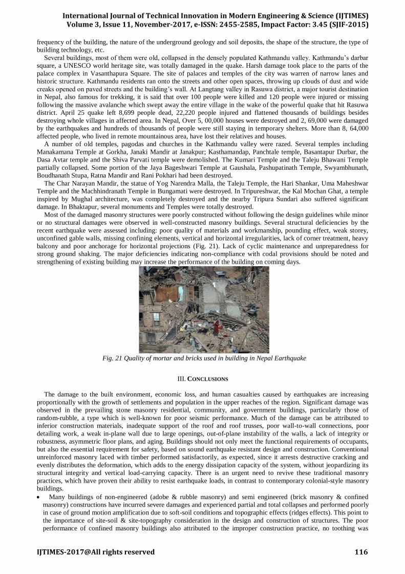
Most of the damaged masonry structures were poorly constructed without following the design guidelines while minor
or no structural damages were observed in well-constructed masonry buildings. Several structural deficiencies by the
recent earthquake were assessed including: poor quality of materials and workmanship, pounding effect, weak storey,
unconfined gable walls, missing confining elements, vertical and horizontal irregularities, lack of corner treatment, heavy
balcony and poor anchorage for horizontal projections (Fig. 21). Lack of cyclic maintenance and unpreparedness for
strong ground shaking. The major deficiencies indicating non-compliance with codal provisions should be noted and
strengthening of existing building may increase the performance of the building on coming days.
Fig. 21 Quality of mortar and bricks used in building in Nepal Earthquake
III. CONCLUSIONS
The damage to the built environment, economic loss, and human casualties caused by earthquakes are increasing
proportionally with the growth of settlements and population in the upper reaches of the region. Significant damage was
observed in the prevailing stone masonry residential, community, and government buildings, particularly those of
random-rubble, a type which is well-known for poor seismic performance. Much of the damage can be attributed to
inferior construction materials, inadequate support of the roof and roof trusses, poor wall-to-wall connections, poor
detailing work, a weak in-plane wall due to large openings, out-of-plane instability of the walls, a lack of integrity or
robustness, asymmetric floor plans, and aging. Buildings should not only meet the functional requirements of occupants,
but also the essential requirement for safety, based on sound earthquake resistant design and construction. Conventional
unreinforced masonry laced with timber performed satisfactorily, as expected, since it arrests destructive cracking and
evenly distributes the deformation, which adds to the energy dissipation capacity of the system, without jeopardizing its
structural integrity and vertical load-carrying capacity. There is an urgent need to revive these traditional masonry
practices, which have proven their ability to resist earthquake loads, in contrast to contemporary colonial-style masonry
buildings.
Many buildings of non-engineered (adobe & rubble masonry) and semi engineered (brick masonry & confined
masonry) constructions have incurred severe damages and experienced partial and total collapses and performed poorly
in case of ground motion amplification due to soft-soil conditions and topographic effects (ridges effects). This point to
the importance of site-soil & site-topography consideration in the design and construction of structures. The poor
performance of confined masonry buildings also attributed to the improper construction practice, no toothing was

International Journal of Technical Innovation in Modern Engineering & Science (IJTIMES)
Volume 3, Issue 11, November-2017, e-ISSN: 2455-2585, Impact Factor: 3.45 (SJIF-2015)
IJTIMES-2017@All rights reserved 117
observed between column and masonry i.e. confining columns was built first and masonry after. However proper
confined masonry construction requires building the masonry wall first, after placing reinforcement skeleton for
confining columns, and then poor concrete for columns later.
Significant amount of medium to good quality constructions (brick masonry buildings) have performed very poorly
in case of local differential settlement due to local soil failure, which was primarily due to improper drainage and
blockage, causing water pounding, that kept the foundation soil wet for years and resulted in the foundation soil to lose
its shear strength capacity for carrying vertical and lateral loads. This calls for attention to improve building drainage
systems.
Damages to infill walls have been observed, which calls for using soft (flexible) infill in the structures. Furthermore,
pounding effects in the structures have been observed which calls for attention in future designs to use soft joint filler
in expansion joints to minimize hammering effects during earthquake.
Structures with timber laces and timber framing have performed better, even in case of using low strength infill
materials. However, in case of large panels, masonry materials detachment and panel out-of-plane failure have been
observed.
From the above discussion it can be understand that there is an urgent need of retrofitting of existing masonry
building in India as it contributes more than 75% of existing building stock and comes under the category of non-
engineered building. Before retrofitting the performance of such building needed to be known.
So a proper guideline for obtaining performance & than retrofitting of masonry building needed to be framed.
REFERENCES
[1] Ahmad, N., (2015). “A Note on the Strong Ground Motions and Behavior of Buildings during 26th Oct. 2015
Afghanistan–Pakistan Earthquake." Earthquake Engineering Center, UET Peshawar.
[2] Chalise, B., and Suwal, R., (2016). "Seismic Performance of Masonry Buildings during Recent Gorkha Earthquake
in Nepal."
<https://www.researchgate.net/publication/290104424>
[3] EERI Special Earthquake Report (2003). "Preliminary Observations on the October 31-November 1, 2002 Molise,
Italy, Earth-quake Sequence."
[4] EERI Special Earthquake Report (2005). "First Report on the Kashmir Earthquake of October 8, 2005."
[5] EERI Special Earthquake Report (2013). “The Mw 6.6 Earthquake of April 20, 2013 in Lushan, China."
[6] EERI Special Earthquake Report (2014). “M 6.0 South Napa Earthquake of August 24, 2014."
[7] Jain, S. K., Singh, R. P., Gupta, V. K., and Nagar, A., (1992) "Garhwal Earthquake of Oct. 20, 1991." EERI Special
Earthquake Report, 26(2).
[8] Jain, S. K., Murty, C. V. R.,, Chandak, N., Seeber, L., and Jain, N. k., (1994). “The September 29, 1993, M6.4
Killari, Maharashtra Earthquake in Central India." EERI Special Earthquake Report, 28(1).
[9] Jain, S. K., Murty, C. V. R., Arlekar, J. N., Sinha, R., Goyal, A., and Jain, C. k., (1997). "Some Observations on
Engineering Aspects of the Jabalpur Earthquake of 22 May 1997." EERI Special Earthquake Report, 32(2).
[10] Jain, S. K., Murty, C. V. R., Arlekar, J. N., Rajendran, K., and Sinha, R., (1999)."Chamoli (Himalaya, India)
Earthquake of 29 March 1999." EERI Special Earthquake Report, 33(7).
[11] Kandilli Observatory and Earthquake Research Institute, (2010). "Basyurt-Karakocan (Elazig) Earthquake March
08, 2010." Bogazici University-Istanbul, Turkey.
[12] Preliminary Reconnaissance Report (2001)." The Nisqually Earthquake Of 28 February 2001." University of
Washington Seattle, WA.
[13] Revolvy. “1906 Ecuador Colombia Earthquake”
<https://www.revolvy.com/main/index.php?s=19 06%20Ecuador%E2%80%93Colombia%20earthquake >
[14] Revolvy. “1950 Assam Tibet Earthquake”
<https://www.revolvy.com/main/index.php?s=1950%20Assam%E2%80%93Tibet%20earthquake >
[15] Rossa, D., and Riyansyah, M., (2017). “M6.5 Pidie Jaya Earthquake, Aceh, Indonesia on December 7, 2016." Build
Change, AARGI, and EERI Earthquake Reconnaissance Report.
[16] Wikipedia “1960 Valdivia Earthquake”
<https://en.wikipedia.org/wiki/1960_Valdivia_earthquake>
[17] Wikipedia “2004 Sumatra Earthquake”
<https://en.wikipedia.org/wiki/2004_Indian_Ocean_earthquake_and_tsunami>
[18] Wikipedia “2011 Tohoku Earthquake”
<https://en.wikipedia.org/wiki/2011_T%C5%8Dhoku_earthquake_and_tsunami>
[19] WSSPC “1952 Kamchatka Earthquake”
<http://www.wsspc.org/resources-reports/tsunami-center/significant-tsunami-events/1952-kamchatka-tsunami/>
[20] Wikipedia “2010 Maule Earthquake”
<https://en.wikipedia.org/wiki/2010_Chile_earthquake >
[21] Wikipedia “1965 Rat Island Earthquake”
<https://en.wikipedia.org/wiki/1965_Rat_Islands_earthquake>
Recommended