LagoViví
LagoCaonillas
LagoAdjuntas
Río Garzas
aqueduct tunnel
Lago deMatrullas
R ío Grande de Manatí
LagoEl Guineo
Río Bauta
ARECIBO
VEGABAJA
VEGAALTA
MANATI DORADO TOA BAJA
BAYAMONTOA ALTA
FLORIDA
MOROVISCIALES COROZAL
UTUADO
NARANJITO
AGUASBUENAS
JAYUYA OROCOVISCOMERIO
BARRANQUITAS CIDRA
AIBONITOCOAMO
50023110
50024950
50025155
50026025
50026140
50026200
5002700050027100
5002760050028400
50031200
50032290
50032590
50034000
50035000
50038100
50038320
5004300050043197
50043800
50044100
50044810
5004500050045010
50046000
50047535
5004755050047560
50047850
50999970
50999975
50999976
50999999
66°10'66°15'66°20'66°25'66°30'66°35'66°40'
18°25'
18°20'
18°15'
18°10'
Base from USGS digital dataLambert conformal conic projection. Puerto Rico DatumMap prepared by the US Geological Survey
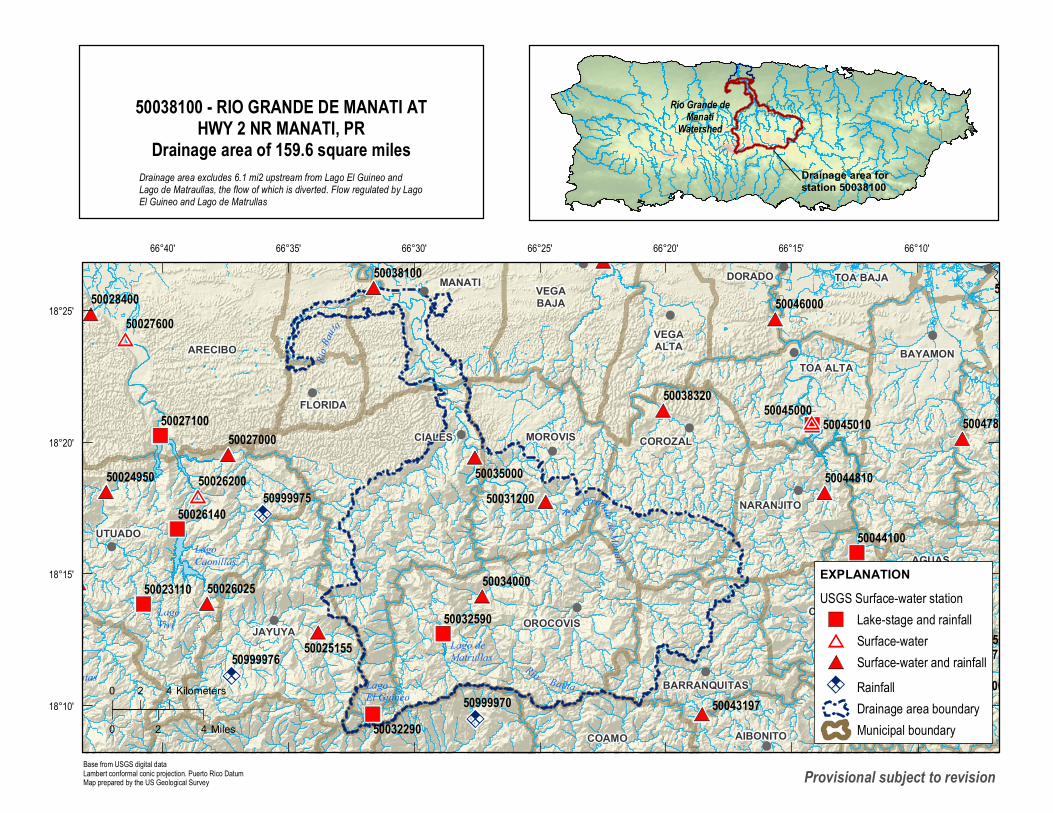
EXPLANATIONUSGS Surface-water station
Lake-stage and rainfallSurface-waterSurface-water and rainfallRainfallDrainage area boundaryMunicipal boundary
0 2 4 Kilometers
0 2 4 Miles
Drainage area forstation 50038100
Río Grande deManatí
Watershed50038100 - RIO GRANDE DE MANATI AT
HWY 2 NR MANATI, PRDrainage area of 159.6 square miles
Río Ba
uta
Drainage area excludes 6.1 mi2 upstream from Lago El Guineo andLago de Matraullas, the flow of which is diverted. Flow regulated by LagoEl Guineo and Lago de Matrullas
Provisional subject to revision
Recommended